Embed Size (px)
Citation preview

11
SOUTHWESTERN CULTURE HISTORY:
COLLECTED PAPERS ·°?
IN uouoa or
ALBERT H. SCHROEDER
Charles H. Lange
Editor
— Contributors: ·
i
Patrick H. Beckett Luke Lyon
Gordon Bronitsky Frances Joan Mathien
l
e .
Hugh Davidson Carroll L. Riley
Herbert W. DickV
Nhdeleine Turrell Rodack
Henry F. Dobyns(
Nhrc Simnons r
Robert C. Euler ‘ Charlie R. Steen
l
Paul H. Ezell William F. Turney
William B. Griffin A. Helene Warren
Myra Ellen Jenkins H John P. Wilson
Marjorie F. Lambert Arnold Withers
_ Richard B. Woodbury .
;.
Papers of the Archaeological Society of New Mexico: 10
Published for the Archaeological Society of New Mexico by
Ancient Ci_ty Press, PO Box 5401, Santa Fe, New Mexico 87502 I
A
A
1985 V
{
” [ ,
‘v "E|€‘ ¢‘
~ |‘|
is
NNO29168

THE LOCATION OF CHICHILTICALEA `
CARROLL L. RILEY
INTRODUCTION discussion of them as needed later in the paper.
_ _ _ _ Serious modern speculation on
Chichilticale known. variously as Chichilticale began with the wave of an Indian ruin, a mountain range and historical and anthropological interest pass, and a "province" was an impor- in the Southwest that followed on the tant way station during the Coronado American occupation of 1846 and the expedition of 1539-42. After the mid- subsequent heavy population movement 1500s the west coast route to Cibola into New Mexico and Arizona. Al- and the Southwest dropped out of use though two early American scholars, _
`
and the location of Chichilticale was E. J. Squier in 1848 and H. C. Morgan eventually lost. In this paper the two in 1869, suggested a Chichilticale
most probable locations, one on the north of the Gila River (Schroeder lower Salt River, the other on the 1955: 294), the commonest early iden- ,. _
upper Gila River, are discussed, and tification of Chichilticale was with
evidence for and against each one is the spectacular site of Casa Grande given. near the Gila River. As late as the
1880s this identification seems to have The site and area of Chichilti- had general acceptance. For example,
cale (variously identified as a moun- according to Hubert H. Bancroft (1886:
tain range, a pass, an Indian ruin, and 84):
. a "province") was important .to the Chichilticale the "red house"
earliest Spanish southwestern expedi- probably is the structure since
p
tions. It stood at the edge of the known as the Casa Grande on last great despoblado separating the the Gila, then as now a roofless populous statelets o Sonora and the ruin.
agricultural populations of the Gila- Drawing on work done in that same Salt Valley from Puebloan Cibola. In decade, however, Adolph F. Bandelier
spite of this importance, the site was made it clear that Casa Grande could never firmly located, and after the not be a serious candidate as the site
mid-16th century it was lost to view. of 16th century Chichilticale. Bande-
Spaniards traveling from Sonora to lier (1892: 408-409) pointed out that
New Mexico in the 18th century made the reasonably explicit descriptions of
no mention of Chichilticale. Since it the country around the ruin of Chichil-
was a kind of mid-point in Coronado’s ticale simply could not be equated with
journey from Sonora to the upper South- the area of the Gila River near Casa
west, a firm location of Chichilticale Grande. Bandelier's own location of is obviously desirable in establishing Chichilticale was in the Fort Grant
the route of the Coronado expeditions area west or south of Fort Graham
and the location of a major pre—Euro— and the Pinaleno Mountains (Bandelier
pean trunk road from Mesoamerica to 1892: 409). In May, 1883, Bandelier
the Southwest. was told of "large-house ruins near
A number of previous attempts Fort Grant" while visiting at Solomon-
have been made to locate Chichilti- ville (Lange and Riley 1970: 99), and
cale. I shall briefly survey some this presumably was the ruin that he
important ones here, returning to a had in mind. 153I NNO29169
in Marcos' footsteps, swung north and no great help to be gained from ar- east, roughly on the route of modern chaeology. Eventually, when the re-
Rf U.S. Highway 80, between the Chiri- gion of Chichilticale is identified with cahua and the Peloncillos, past pres- reasonable certainty, the archaeolog- ent-day Rodeo, New Mexico. The ruin ical evidence will be useful. The cur-
. of Chichilticale was one of the sites rent incomplete description of the ruin in the San Bernardino Valley. From (given only by Castafleda) fits so many Antelope Pass Coronado’s army moved different areas of the Southwest that northwestward to the Duncan area, it gives very little in the way of leads. recrossing the New Mexico-Arizona Indeed, some authors (Schroeder, for line at that point. The party then example) have been skeptical of the went down the Gila to about the town value of Castafleda's "Red House" com- of Guthrie and overland approximately ments. to modern Clifton. At that point The first Old World individuals Coronado moved up the San Francisco to see Chichilticale may have been
_ and then the Blue River, again recross- Esteban and Marcos de Niza in the ,
ing the state line to Luna and Spur spring of 1539. These two men led Lake. The journey continued north- the first of a series of expeditions di- ward, entirely on the New Mexico side rected by Francisco Vasquez de Cor- of the modern state line, crossing onado, from the Spanish-controlled ,_ Carrizo Wash (Coronado's Bermejo areas of central and west Mexico to River) and on to the Zuni River below the Greater Southwest. Unfortunately, Hawikuh. This route differs consider- Esteban was killed at Cibola (Zuni)
ably from the traditional ones which and so never returned to tell his story. have had Coronado traveling by Fort Marcos did not actually mention Chi-
Apache and White River (Bolton 1964: chilticale in his summary accounts to
110) or through the Tonto Basin Viceroy Mendoza but, from later com- (Schroeder 1956: 32). In both of these ments of Coronado, it is generally
proposed routes, Coronado went on assumed that Friar Marcos had indeed
over the Mogollon Rim and his Rio seen or heard of the place (Hammond Bermejo was the Little Colorado. and Rey 1940: 165).
I have discussed Chichilticale in Chichilticale was also visited by a number of papers (Riley 1975, 1980, a second exploratory expedition sent
1982) but I have always been rather by Coronado in the winter of 1539-40
cautious about choosing one route over and led by Melchior Diaz. The latter
the others in the face of conflicting man did not actually use the name in and often scanty evidence. I did sug- extant reports but later testimony by
gest (Riley 1982: 10, Fig. 4; 11, Fig. one of his soldiers did mention that
5; 63) two alternate routes for Coron- Chichilticale was about 60 leaguesI
ado and two locations for Chichilti- from Cibola (ICC, Juan de Zaldivar
cale, one essentially that of Schroeder test.). Diaz' own statements indicatedI
with a Salt River location, and the that it was a very cold area.
other a variant on DiPeso with Chichil- Coronado, leading a vanguard to
ticale located on the upper Gila River. his expeditionary forces in the spring
I also made another stab at linguistic and early summer of 1540 marched
identification of the placename, sug- from San Miguel de Culiacan to Cibola.
gesting that it might be some variation He reached Chichilticale on June 19
on the Piman word for house, Eh or after a trip of indeterminate length
kihki (1982: 67). from the large Indian settlements of
Turning now to the actual evi- Corazones. Coronado found that Chi-
dence for Chichilticale, it might be chilticale was 15 days from the sea
well to say that, at present, there is (Hammond and Rey 1940: 165), and
155
NNO2917O
j, . ·
_A Chichilticale somewhere in the and Sauer identifications and placed · vicinity of the Pinaleno Mountains was Chichilticale on the 76 Ranch at the
accepted rather widely. In his land- foot of Eagle Pass (Bolton 1964: 106) mark publication of accounts of the Bolton also made a stab at identifying Coronado journey, George P. Winship the name Chichilticale. I-le believed (1896: 73) repeated the Bandelier iden- that it might be derived from "Chi- tification with evident approval. In chilte and calli two Yaqui words addition, the location in the Handbook still in use:`HEl they still mean red g_f_ American Indians (Hodge 1907: 259) house." Presumably, Bolton inadvex: "on the Gila, E. of the mouth of the tently substituted the name "Yaqui"
San Pedro, S. Ariz., probably not far for "NahuatI."
from Solomonsville" was essentially A. L. Schroeder, in 1955, pub-
that of Bandelier. lished an analysis of the placement of A detailed study of the Chichilti- Chichilticale. Following, to some
· cale question was published in 1908 degree, the work of Potter, Schroeder by Samuel O. L. Pottgr, an army sur- (1955: 294) suggested that the ruin of
geon who had traveled through south- Chichilticale is on the Salt River near ern Arizona in the late 1860s. Potter the mouth of Salome Creek. He also . .
located Chichilticale opposite the (p. 295) discussed the meaning of the
mouth of Pinal Creek on the north word Chichilticale. Aside from the
side of Salt River north of the present- identification of Chichiltic—calli as
day town of Globe, some 130 km north- ‘ "Red House" in Molina's 1550 Aztec-
west of the Bandelier location (Potter Spanish dictionary, there were other
1908: 273). possibilities for the word. Schroeder
Little additional work was done suggested the Apache Tli—chi-kowa,
on Chichilticale until 1932 when Carl meaning "Red House," or the Apache
O. Sauer published his landmark Road Chi-chil-kain which referred to the
_tg_Cibo1a which investigated anew the Oak People Clan. The Yavapai word
routes of the early explorers to the Chi-chi-itch-kwali with a meaning
Southwest. In general, Sauer agreed "Mother Plants" was one that had to
with Bandelier in the location of Chi- be taken seriously in that SchroedeT·’ I
chilticale. Like Bandelier, Sauer (1956: 33) believed that the Coronado
believed that the Coronado party jour- groups first encountered Yavapai Indi-
neyed up the San Pedro River and then ans in the region of Chichilticale.
up Arivaipa Creek and over Eagle Pass No major new speculation on Chi-
between the Pinaleno and Santa Teresa chilticale occurred until the publica-
mountains. Sauer gave two likely loca- tion of C. C. DiPeso’s monumental
tions for Chichilticale. He believed work on Casas Grandes. DiPeso
it to be either in the Arivaipa Basin, (DiPeso, Rinaldo and Fenner 1974: 98-
at the Haby ranch, or on the bluffs 102) had a variant route for the early
of the Gila about a mile north of Spanish parties. He believed that both
Geronimo and a bit downriver of Fort Marcos and Coronado traveled first up
Thomas. the Bavispe River and then the Bate-
A rather different location was pito and the San Bernardino, crossing
given by George J. Undreiner (1947: the present international border at a
460). Undreiner believed that the site point a few kilometers east of Agua
was first visited by Fr. Marcos de Niza Prieta. _l·Q_s Chichilticale was in the
in 1539 and that it could be identified region of the San Bernardino drainage.
with the cliff dwellings in present-day The Sierra of Chichilticale included
Tonto National Monument. Herbert E. the Sierra de San Luis and the Pelon-
Bolton, however, writing in 1949 es- cillo Mountains (PP. 98-99). According
sentially went back to the Bandelier · to DiPeso, Coronado’s party, following
154
NNO29171

spoke to Indians there who had made They live by hunting, and in
Qr the trip. He also spoke of the "Port rancherias, without permanent
K of Chichilticale" though it is not clear settlements, Most of the region just where this "port' was located. It is uninhabited. There are large can hardly be at 35°N. latitude (that pine forests and pine nuts in
of Zuni) as Coronado claimed to have abundance. The pines that are heard from Marcos. On leaving Chi- found are squatty and have long chilticale after a two-day stay Cor- branches upward of two or onado encountered a 30 league despob- three estados in height. There
lgd_g with mountains and dangerous are oak trees bearing sweet passes (Hammond and Rey 1940: 166). acorns, and fanonas which pro-
One of Coronado’s lieutenants, duce a fruit like that from Juan de Jaramillo, also talked of Chi- which coriander preserves are chilticale. According to Jaramillo the made. When dried the fruit is
party traveled down the arroyo "which very sweet, like sugar. In some — we understood was called Nexpa" for streams watercress was found,
two days. After an additional two and there are also vines, penny- days the party reached "the foot of royal, and wild marjorum. In
the cordillera, where we learned that the rivers of this despoblado it was called Chichilticalle" (Hammond there are barbels and picones
{ (
and Rey 1940: 297). From Chichilti- as in Spain. Gray lions were cale the party went into rugged and seen from the beginning of the high country (p. 298). A despoblado. The land rises
Pedro de Castaileda de Naxera gradually until one reaches
who was with the main Coronado army, Cibola, which is eighty leagues several weeks behind the vanguard, by the northern route.
also saw and described _Chichilticale From Castafieda's account it
"where the despoblado began" (p. 207). would seem that the inhabitants of
The men were disillusioned to find that Chichilticale as of 1540 were not the "the famous Chichilticale turned out builders of the Red House at least in to be a roofless ruined house, although Castaneda's mind. They were barbar-
it appeared that formerly, at the time ous rancheria-builders who lived in
it was inhabited, it must have been a great part by hunting. The relatively fortress" (p. 207). Fifteen days march detailed description of the flora and
from this red mud ruin, the party fauna in Castaneda should give us some
reached the Rio Bermejo (p. 208). clues to the location of Chichilticale
In another part of his narrative - unfortunately, it serves about equal- Castaneda (pp. 251-252) gave our most ly well for the high country south of
detailed description of Chichilticale: the Mogollon Rim and for the upper Chichilticale received its Gila drainage. The pines described by
name because the friars found Castatleda very likely include Ponder-
in this region a house formerly osa (Pinus nderosa and Pgarizonica) inhabited by people who broke and pinon edulis). The oaks men-
away from Cibola. It was built tioned cannot be identified beyond the
of brown or red earth. The genus Quercus but a number of oaks
house was large and showed are represented in the mountainous
clearly that it used to be a for- areas of southern Arizona and south-
» tress. It must have been de- ern New Mexico. The fanona tree
spoiled by the natives of the with its sweet fruit is more difficult.
region, the more barbarous Strout (1971: 16) identified it as the
people thus far encountered. anona or custard apple (Annona sgua-
156
NNO29172

_
mosa). This plant, however, has a seen three or four of these
A more tropical distribution, and as near sheep, and that they were very as I can tell, did not appear aboriginal- fleet (Day 1940: 93). ly in Arizona. One of the native fruit
, trees, or even one of the fruit pro- Surveying the various attempts ducing cactl may have been meant. to route Marcos and Coronado and the The "watercress" mentioned at Chi- scattering of locations for chilticale, Strout (1971: 17) believed Chichilticale, it seems clear that no was Nasturtium officinale. Castaneda single routing and location fits all the also mentioned "poleo" pennyroyal at evidence at hand. Like all students Chichiltical as well as oregano. of this matter, I have made my own Neither of these plants is native, but choices in interpreting the data, and Strout (1971: 23) suggested that mock these choices must determine my own pennyroyal (Hedeoma drummondii) may "judgment call" as to where Chichil-
_ have been meant for the former. Any ticale should be located. First, I agree .
one of a number of grasses or riverine with Undreiner and Schroeder as to
weeds might have been called "oreg- the basically western path of Marcos ano." de Niza. Like Undreiner, I locate
Castai'leda's "barbels" and "pi— Marcos' town of Vacapa somewhere in ,._
cones" were identified by F. W. Hodge teh Altar-Magdalena Valley (Riley
as catfish and Gila trout (Hammond 1971: 290, 311; 1976: 15; 1980: 44;
and Rey 1940: 252). Whatever their 1982: 9, 10, fig. 4). I am, however,
specific identification, they are not uncertain as to whether Marcos actu-
very diagnostic as the alternative Io- ally made the final leg of the journey cations for Chichilticale discussed to Cibola. If he, in fact, turned back,
below are on the same river system. was it before or after he arrived at
Castaneda's "gray lions" are most Chichilticale?
probably mountain lions, but these are There is one point on which I
too widespread to be of any use in am at odds with most people who have
establishing the area of Chichilticale. studied the Coronado documents. That
None of the other extant Coron- is, I do not believe that Marcos and
ado documents mentioned Chichilti- Coronado took the same route, at least
cale. The papers of Pedro de Tovar, for the Mexican portions of their trips.
now lost, were available in the 17th The main reason that people accept a
and 18th centuries and the lawyer- single route for the two men is that
historian Matias de la Mota Padilla, Marcos in 1540 was supposed to have
who wrote about two centuries after "guided" Coronado to Cibola. A care- Coronado, seems to have made some ful reading of the relevant documents,
use of them. According to Mota Pa- however, really does not support this
dilla the Coronado party _
presumption and common-sense consid- eration makes it most unlikely. If
went through a little pass, Undreiner, Schroeder, and I are cor-
which they named Chichilticali rect, Marcos stayed near the Gulf of
(that is to say, 'red house,' California until he reached northwest-
after one that was in it plas- ern Sonora, This would have been a
tered with red earth called most impractical route for Coronado
ochre); here they found pine with numbers of horses (and, with the
trees with large cones of very main Coronado army, stock animals and ,
good pine-nuts. Further on, at carts). Water and grass for such a
the top of some rocks, they large number of animals cannot be
found sheep skulls with large found near the coast at least from
horns, and some said they had northern Sinaloa northward. Of course
157
NNO29173

on the last leg of the journey, Marcos *°an€€• <¤¤¤ti¤¤i¤s °n n°l`th» the
·% and Coronado could have followed the O°l`°¤8d° P¤l`tY might hal"? 8°¤€ "UP
same route, though even here (gore. Salome Creek and over the north and
nado would surely have preferred the 0f the Sl€F!‘8 Anchas and then
Sonoran guides that we know were generally northeast over the Mogollon
with the party. Rim across to Zuni" (Schroeder 1956: At the present state of knowl- 32). At any rate this seems to fit
edge there really seems no way to the chronicle evidence better than the
establish a premiere single location for alternative route proposed by Bolton Corazones. Depending ona given rout- (1964: 109-10) which had the group ing of various Coronado parties it does crossing the Salt River at about the
seem to me that there are two most mouth of Bonita Creek and continuing reasonable possibilities. I shall call northward into the Fort Apache and them Chichilticale west and Chichil- White River areas to the Mogollon
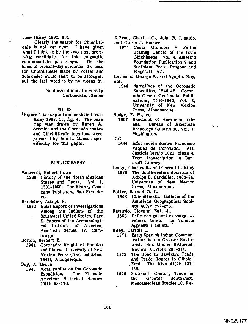
_ ticale gs; (see Fig. 1).1 Rim, in part following the route of
the modern Arizona State Highway 73.
Chichilticale west. .If one traces the If the Pinal-Salt-Salome route is
Marcos and Coronado expeditions correct, the Indians encountered in the
northward from the San Pedro/Gila Chichilticale area were probably, .
junction, they likely entered the Salt Yavapai as Schroeder (1956: 33) has
River Valley along or near a route suggested.
suggested by Potter and Schroeder. . To give Schroeder's (1955: 285) excel- Chichilticale east. In a recent
lent summation of the situation: publication (Riley 1982: 10, fig. 4, 11,
The most simple route from fig. 5) I accepted Schroeder's place-
Globe to the Salt River would ment of Chichilticale and routing of
have been to go down Pinal Coronado as one alternative, but
Creek to Wheatfields, which is mapped a second routing with Chichil-
located just above the point ticale located some 240 km to the east. where the canyon boxes up. If I were to postulate an
From here a traveler only would eastern route, I would have the
have to go over a low pass to Coronado party swing through
the east and then follow a the edge of Mimbres country
northeastern flowing arroyo to -eventua1ly crossing the Gila
the Salt River, opposite the somewhere around Cliff and
mouth of Cherry Creek. At roughly following the route of
this point, except when the modern U.S. Highway 180 to the
river is high during the spring region of Luna—then either
thaws, one can easily ford the northward to Zuni or more
Salt River. likely northwestward into the
Given this route, it would seem Little Colorado drainage
that the gig of Chichilticale would (Riley 1982: 63).
be one or the other large mounds on This route or some variation on
the north side of the Salt, now covered it has a number of things in its favor.
by Roosevelt Dam (Schroeder 1955: For the most part it is an easier route,
285) or perhaps specifically a ruin a taking advantage of wide areas of rel-
small distance downriver and across atively flat land, but with mountains
the Salt from the mouth of Pinal Creek near enough for fodder and water. An (Potter 1908: 273). In such a case, eastern location of Chichilticale and
also, the "Sierra of Chichilticale" an eastern route for Coronado would
would be the Sierra Ancha and the explain the curious lack`of information
"Pass of Chichilticale" in the same that Coronado had concerning native
158
NNO29174

,».
`
FIGURE l—
ALTERNATE LOCATIONS OF CHICHILTICALE
4
COLORADO - 2 Al; ° K A
a *°
S V
*,>
6_ R| LA , ,.
_
ARIZONA OO { °
EE
|5* T n,
I <~· B4
GM zi; rnuvnaass NEW MEXICO
1
·-
/ O
Qt .. %I§A soss (978,06
vp S°"’°"° {| [ Chihuohuo
Tg |e° .°
3'x
F `|
9
¤ 100 200
Kilometers |I `
··--·--• CORONADO RouTE VIA CHICHILTICALE WEST
-·•-•--- CORONADO ROUTE VIA CHICHILTICALE EAST • • • ° ° • ' ALTERNATE ROUTE UP YACQUI VALLEY
° CHICHILTICALE WEST ‘ ' CHICHILTICALE EAST
159
NNO29175
populations in the Gila-Salt area, com- gested by DiPeso) up the San Bernar- pared to Marcos whose i¤f¤¤‘m&fi¤¤ is dino then following the line of modern
I relatively detailed. This would, of route 80 into the Animas Valley seems course, indicate that Coronado and most logical. However, rather than Marcos followed different trails not swinging westward into the tangled only in the Mexican portion of their mountains of the San Francisco and trips but in the American portions as Blue rivers, I think Coronado may have well. In such a case, Marcos presum- followed the relatively easy terrain
ably never saw Chichilticale in 1539, now used by Route 180, perhaps reach- visiting it for the first time as part ing the Gila somewhere in the Cliff of the Coronado party in 1540. This area. Chichilticale may have been one does make Coronado’s statement in his of the Salado or Cliff Phase ruins in letter to the viceroy dated August 3, that region. As he went north, Coron- 1540 (Hammond and Rey 1940: 165), ado would have been in or near stands difficult to explain for Coronado of ponderosa and pinon as described
`
stated that Marcos had given him by Castaiieda. The Sierra of Chichil- specific information on Chichilticale ticale might then be the Mogollon that proved to be false. The informa- Mountains. DiPeso had the party con- tion (that the sea was only five leagues tinuing up the New Mexico side of the ,
distant at Chichilticale and that there present state boundary, but it is hard was a "Port" of Chichilticale) did not to believe that Carrizo Wash could appear, of course, in the Marcos re- have been the Bermejo River of the
. port, and Undreiner (1947: 459) Spaniards. I would rather think that ”
doubted that Marcos ever gave such Coronado, following a well-marked information to Coronado. This may native trail with native guides,
well have been the case especially recrossed the border and came out in since the Coronado letter to Mendoza the upland valleys in the area around that gave these data is known only present-day Alpine. From there the from an Italian text of Ramusio (1556) route ran northward up the headwaters and may well be corrupt. Still and of the Little Colorado and on to the
all, reading such evidence as we do Zuni. The trail across the San Fran-
have, it is hard to believe that Marcos cisco Mountains would admittedly be had not at least heard of Chichilticale rough but there is no way in which in 1539. "Heard," in fact, may be the Coronado can be routed that does not
operative word. If one assumes that offer serious terrain difficulties at one
Marcos did not get all the way to point or another.
Cibola and actually described it ·from If Chichilticale was in the upper
hearsay, the same may be true of Chi- Gila drainage, the barbarous Indians
chilticale. Such a situation does were not likely to have been Yavapai.
suggest that Chichilticale was an In such a case, I suggest that early
important native landmark on the road groups of Apache may have been in- · to Cibola. volved. I realize some scholars hesi-
If the Chichilticale east location tate to believe that the Apache were is correct, the area would have actu- as far south and west as the Arizona-
ally been first seen by the Diaz party New Mexico border area in 1540 but in the winter of 1539. Both the latter based on documentation from the
explorer and the two main Coronado slightly later Espejo expedition, I have
_ parties likely came up the Sonora Val- suggested that Apache and perhaps
ley, and then northeastward to the even Navajo were in western New Mex- '
Agua Prieta area. A route (first sug- ico and eastern Arizona by Coronado’s
160
NNO29176
_ time (Riley 1982: 96). DiPeso, Charles C., John B. Rinaldo,
if Clearly the search for Chichilti- and Gloria J. Fenner cale is not yet over. I have given 1974 Casas Grandes: A Fallen what I think to be the two most prom- Trading Center of the Gran
I ising candidates for this enigmatic Chichimeca. Vol. 4, Amerind ruin-mountain pass-range. On the Foundation Publication 9 and basis of present-day evidence, the case Northland Press, Dragoon and for Chichilticale made by Potter and Flagstaff, AZ. Schroeder would seem to be stronger, Hammond, George P., and Agapito Rey, but the last word is by no means in. eds.
· 1940 Narratives of the Coronado Southern Hlinois University Expedition, 1540-42. Coron-
Carbondale, Illinois ado Cuarto Centennial Publi- cations, 1540-1940, Vol. 2,
. University of New Mexico_
NOTES Press, Albuquerque. 1Figure 1 is adapted and modified from Hodge, F. W., ed.
Riley 1982: 10, fig. 4. The base 1907 Handbook of American Indi-
map was drawn by Karen A. ans. Bureau of American _,_
Schmidt and the Coronado routes Ethnology Bulletin 30, Vol. 1. and Chichilticale locations were Washington. prepared by Joni L. Manson spe- ICC cifically for this paper. 1544 lnformacién contra Francisco
· Vaquez de Coronado. AGI ‘
Justicia legajo 1021, pieza 4. From transcription in Ban-
BIBLIOGRAPHY · croft Library. Lange, Charles H., and Carroll L. Riley
Bancroft, Hubert Howe 1970 The Southwestern Journals of 1886 History of the North Mexican Adolph F. Bandelier, 1883-84.
States and Texas. Vol. 1, University of New Mexico 1531-1800. The History Com- Press, Albuquerque.
pany Publishers, San Francis- Potter, Samuel O. L._
co. 1908 Chichilticalli. Bulletin of the
Bandelier, Adolph F. American Geographical Soci- 1892 Final Report of Investigations ety 40(5): 257-276.
Among the Indians of the Ramusio, Giovanni Battista Southwest United States, Part 1556 Delle navigationi et viaggi
·
II. Papers of the Archaeologi- volume terzo. In Venetia cal Institute of America, appressi i Guinti.
American Series, IV. Cam- Riley, Carroll L.
bridge. 1971 Early Spanish-Indian Commun- Bolton, Herbert E. ication in the Greater South-
1964 Coronado: Knight of Pueblos west. New Mexico Historical and Plains. University of New Review XLVI(4): 285-314. Mexico Press (first published 1975 The Road to Hawikuh: Trade 1949), Albuquerque. and Trade Routes to Cibola-
Day, A, Grove _Zlmi. The KIV8 41(2): 137-
1940 Mota Padilla on the Coronado 159.
Expedition. The Hispanic 1976 Sixteenth Century Trade in
American Historical Review the Greater Southwest.
20(1): 88-110. Mesoamerican Studies 10, Re-
161
NNO29177

L search Records of the Univer- ado and the Yavapai. New
T sity Museum, Southern Illinois Mexico Historical Review University, Carbondale. XXX(4): 265-296.
1980 Mesoamerica and the Hoho— 1956 Fray Marcos de Niza, Coron- kam: A view from the Six- ado and the Yavapai (conclu- teenth Century. In Current sion). New Mexico Historical Issues in Hohokam Prehistory: Review XXXI(1): 24-37. Proceedings of a Symposium. Strout, Clevy L. Edited by D. Doyel and F. 1971 Flora and Fauna ment_ioned in Plog, Arizona State Universi- the Journals of the Coronado ty Anthropological Research Expedition. Great Plains
_
Papers, 23: 41-48, Tempe. Journal 1l(1): 5-40. 1982 The Frontier People: The Undreiner, George J.
Greater Southwest in the 1947 Fray Marcos de Niza and his — Protohistoric Period. Center Journey to Cibola. The
for Archaeological Investiga- Americas 3(4): 415-486. tions, Occasional Papers, No. Winship, George P. 1, Southern Illinois Universi- 1896 The Coronado Expedition.
ty, Carbondale. 1540-1542. Q Fourteenth .. s .
Sauer, Carl O. Annual Report of the Bureau L
1932 The Road to Cibola. Ibero- of Ethnology, 1892-1893, part Americana 3. _ 1, pp. 329-613, Washington. U
Schroeder, Albert H. ‘ "
1955 Fray Marcos de Niza, Coron-
NNO29178