Embed Size (px)
Citation preview

http://upload.wikimedia.org/wikipedia/commons/0/0e/Nasa_earth.jpg
SPACESHIP EARTH

commons.wikimedia.org
SPACESHIP

SOURCE: sciencebehindenvironmentalissues.blogspot.com/2010/01/spheres-of-earth.html
LIFE ON SPACESHIP
EARTH IS MADE POSSIBLE BY A
COMPLEX SYSTEM OF
CONNECTED, INTERACTING
SPHERES
Layer of protective gases: 78% nitrogen, 21% oxygen, 0.93% argon, 0.038% carbon dioxide, trace gases, 1% water vapor
The ANTHROSPHERE is that part of the environment that is made or modified by humans for use in human activities.
or Geosphere about (100 km = 60 miles thick) is the solid part of Earth’s crust
Part of the Hydrosphere consisting of frozen water
Includes all organisms (living & dead) and all other Spheres
Interacts with and is influenced by all other Spheres
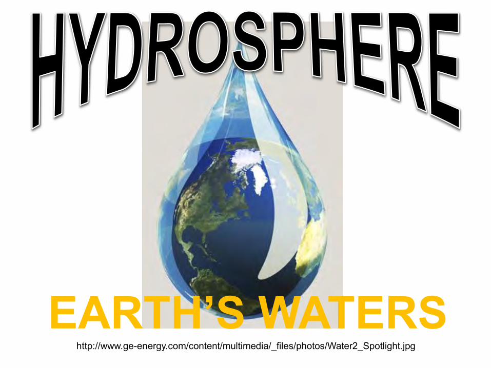
http://www.ge-energy.com/content/multimedia/_files/photos/Water2_Spotlight.jpg
EARTH’S WATERS

http://photojournal.jpl.nasa.gov/jpeg/PIA00728.jpg

Drop-In-A-Bucket
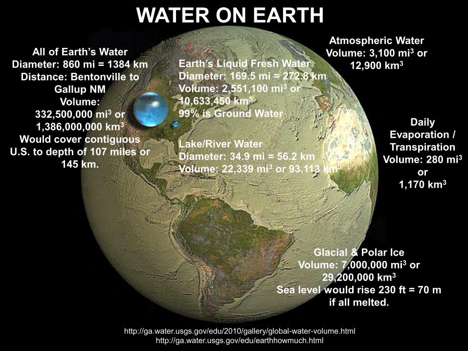
WATER ON EARTH
http://ga.water.usgs.gov/edu/2010/gallery/global-water-volume.html http://ga.water.usgs.gov/edu/earthhowmuch.html
All of Earth’s Water Diameter: 860 mi = 1384 km
Distance: Bentonville to Gallup NM Volume:
332,500,000 mi3 or 1,386,000,000 km3
Would cover contiguous U.S. to depth of 107 miles or
145 km.
Earth’s Liquid Fresh Water Diameter: 169.5 mi = 272.8 km Volume: 2,551,100 mi3 or 10,633,450 km3 99% is Ground Water
Lake/River Water Diameter: 34.9 mi = 56.2 km Volume: 22,339 mi3 or 93,113 km3
Atmospheric Water Volume: 3,100 mi3 or
12,900 km3
Glacial & Polar Ice Volume: 7,000,000 mi3 or
29,200,000 km3 Sea level would rise 230 ft = 70 m
if all melted.
Daily Evaporation / Transpiration
Volume: 280 mi3 or
1,170 km3
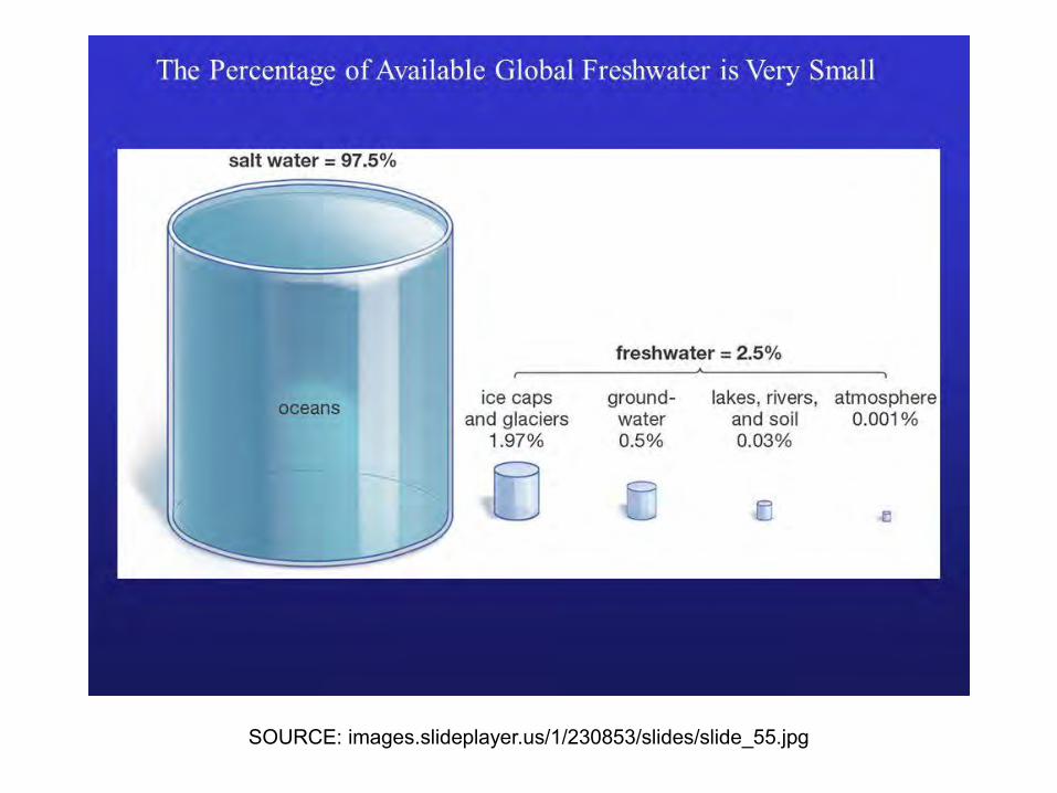
SOURCE: images.slideplayer.us/1/230853/slides/slide_55.jpg

SOURCE: water.usgs.gov/edu/watercycle.html

Water Cycle Misconceptions
http://esd113.org/cms/lib3/WA01001093/Centricity/Domain/46/Page%20Keeley%20Presentation%20May%2022%202012.pdf

Energy, Evaporation, and Condensation
• Evaporation and Energy Activity
– Pay attention to where you hold the thermometer and swipe technique.
• Condensation and Energy Activity
http://www.schools.utah.gov/CURR/science/SSECC/ArthurPresentationEvaporation.aspx
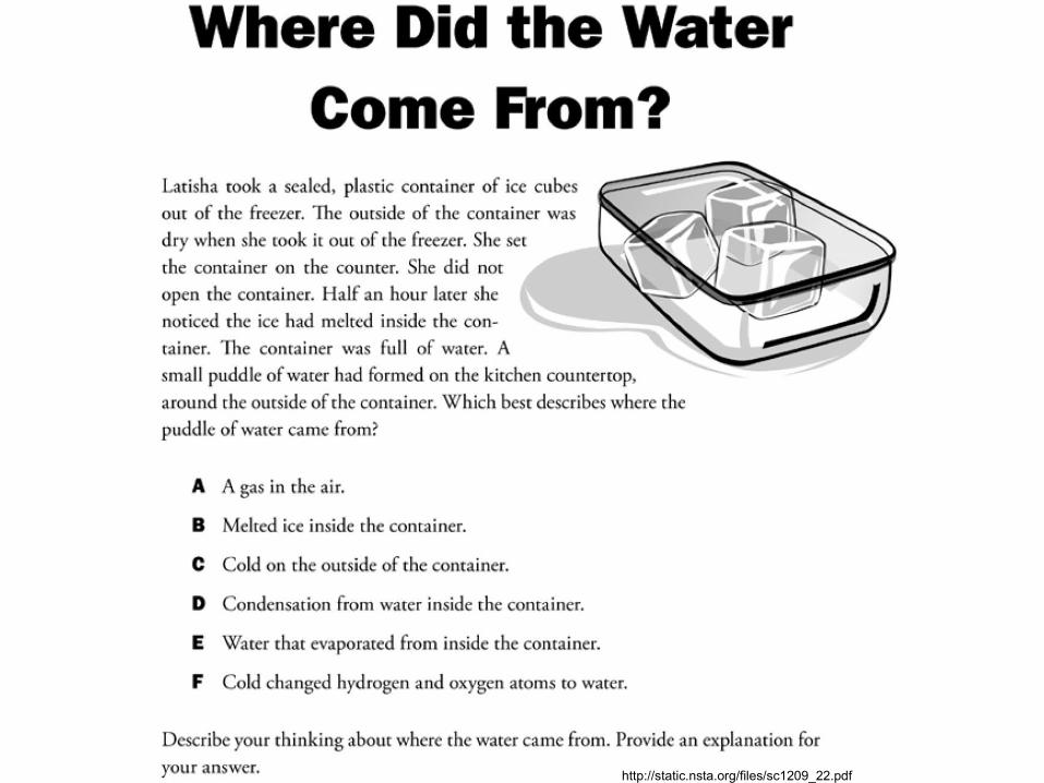
http://static.nsta.org/files/sc1209_22.pdf

• What do we understand at this point about evaporation and condensation and the energy relationships associated with each?
• How do you think the sea surface temperature will change when a hurricane passes over? Will the sea surface have a net gain or loss of energy? How does a hurricane transfer energy?

Source: http://www.sswm.info/category/concept/water-cycle
The WATER CYCLE is made up of processes that continually move water from the sky downward onto, across, into, and below Earth’s surface, and then back up to the sky.

WATERSHED SIZES & SHAPES
Where in the World is BLWS?

Source: http://www.sci.uidaho.edu/scripter/geog100/lect/11-rivers/11-rivers.htm
A watershed is an "area of land that drains water, sediment, and dissolved materials” to the lowest elevation point within it, such as a common water body or “outlet along a stream
channel.” (Paraphrased from Dunne and Leopold 1978). Source: http://www.epa.gov/owow/watershed/wacademy/acad2000/stream/stream11.html
WATERSHED = CATCHMENT = DRAINAGE BASIN

Source: http://www.sci.uidaho.edu/scripter/geog100/lect/11-rivers/11-rivers.htm
MAJOR NORTH AMERICAN DRAINAGE BASINS

Source: http://geophysics.ou.edu/geol1114/notes/running_water/running_water.html
Natural Drainage Patterns Shape of the stream systems draining a particular region

Source: http://www.bwdh2o.org/files/45/2010_FINAL_Beav
er_Lake_Watershed_Report.pdf
THE WHITE RIVER IS A SUB-WATERSHED OF THE MISSISSIPPI RIVER DRAINAGE BASIN THE BEAVER LAKE WATERSHED IS A SUB-WATERSHED OF THE WHITE RIVER.

WATERSHEDS & Sub-Watersheds Like stacking bowls, a WATERSHED may be part of one that is larger and also have other smaller “SUB-WATERSHEDS” inside it.
THE BEAVER LAKE WATERSHED IS AN AREA OF LAND THAT COLLECTS AND DRAINS
PRECIPITATION INTO BEAVER LAKE.
THE WHITE RIVER WATERSHED IS A SUB-WATERSHED OF THE
MISSISSIPPI RIVER DRAINAGE BASIN.
THE BEAVER LAKE WATERSHED IS A SUB-WATERSHED OF THE
WHITE RIVER WATERSHED.
THE BEAVER LAKE WATERSHED INCLUDES SUB-WATERSHEDS OF 7 MAJOR STREAMS:
1) White River Headwaters 2) West Fork of the White River 3) Middle Fork of the White River 4) White River/Lake Sequoyah 5) Richland Creek 6) War Eagle Creek 7) Beaver Lake/White River
SOURCE: hillnholler.files.wordpress.com/2013/07/white-river-watershed.png
SOURCE: www.mississippiriveradventures.com/picts/Mississippi-map.gif SOURCE: www.bwdh2o.org/files/45/2010_FINAL_Beaver_Lake_Watershed_Report.pdf
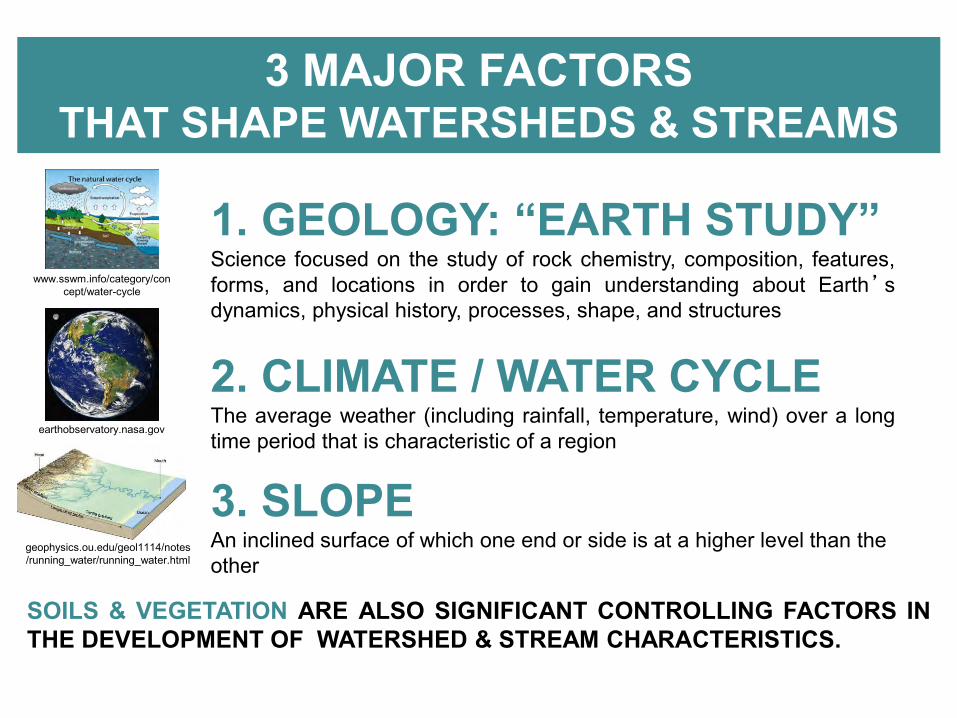
3 MAJOR FACTORS THAT SHAPE WATERSHEDS & STREAMS
1. GEOLOGY: “EARTH STUDY” Science focused on the study of rock chemistry, composition, features, forms, and locations in order to gain understanding about Earth’s dynamics, physical history, processes, shape, and structures
2. CLIMATE / WATER CYCLE The average weather (including rainfall, temperature, wind) over a long time period that is characteristic of a region
3. SLOPE An inclined surface of which one end or side is at a higher level than the other
SOILS & VEGETATION ARE ALSO SIGNIFICANT CONTROLLING FACTORS IN THE DEVELOPMENT OF WATERSHED & STREAM CHARACTERISTICS.
earthobservatory.nasa.gov
www.sswm.info/category/concept/water-cycle
geophysics.ou.edu/geol1114/notes/running_water/running_water.html

GEOLOGY & DRAINAGE PATTERNS Shape of the stream systems draining a particular region
Dendritic: “Tree Trunk & Branches” Most common drainage pattern resulting from flow of water over gently inclined flat-lying rock formations.
Rectangular: “Square-Corners” Forms on rocks with well-developed joint system.
Trellis: “Trained Vine” Streams flowing on “folded” SEDIMENTARY rock units
follow valleys bounded by ridges of erosion resistant rock.
Radial: “Wheel Spokes” Develops on a large single peak, such as a salt dome or volcano.
Example: Hawaiian Islands, Mt. Shasta/CA
SOURCE: www.studyblue.com
Example: Springfield Plateau Ozark Region
SOURCE: www.onegeology.org
Example: Appalachian Mountains Virginia & Pennsylvania Example: Canadian Shield
SEDIMENTARY ROCKS
Limestone Sandstone Limestone
IGNEOUS or METAMORPHIC
ROCKS

Source: http://www.bwdh2o.org/index.php?fuseaction=p0007.&mod=42
WATER FLOW FROM THE SURFACE TO BELOW GROUND IN A WATERSHED WITH LIMESTONE “KARST” TOPOGRAPHY SUCH AS IS FOUND IN THE
BEAVER LAKE WATERSHED

Source: http://www.bwdh2o.org/files/45/2010_FINAL_Beav
er_Lake_Watershed_Report.pdf
The DENDRITIC drainage pattern is characteristic of the Ozark Plateau Province and the Beaver Lake Watershed.

CLIMATE: THE AVERAGE WEATHER (INCLUDING RAINFALL, TEMPERATURE, WIND) OVER
A LONG TIME PERIOD THAT IS CHARACTERISTIC OF A REGION
Source: www.weaselinthebarley.com/scenic_
wallpapers/desert.htm
WOODLANDS: Rainfall Moderate <75-150 centimeters = <30-60 inches per year
Source: www.airphotona.com/image.asp?im
ageid=1742
Source: http://commons.wikimedia.org/wiki/File:ClimateMapWorld.png
Source: http://www.kansasforests.org/n
ewindex.shtml
Source: http://www.geograph.org.uk/phot
o/2427529
RAINFORESTS: Rainfall Maximum <175-200 centimeters = <69-79 inches per year
Source: http://burns1.wikispaces.com/Southeast+Asian+Rainforest
Source: http://photos.igougo.com/picture
s-photos-p211084-rain_forest.html
GRASSLANDS: Rainfall Minimal Temperate: <25-75 centimeters = <10-30 inches per year Tropical: <64-150 centimeters = <25-60 inches per year
DESERTS: Rainfall Negligible Arid: <0-10 centimeters = <0-4 inches per year Semi-Arid: <10-30 centimeters = <4-12 inches
http://www.kidcyber.com.au/topics/biomegrass.htm
http://www.americansouthwest.net/wyoming/yellowstone/pelican-
grasslands.html

SLOPE An inclined surface of which one end or side is at a higher level than the other
Deposition Surface
Source: www.sci.uidaho.edu/scripter/geog100/lect/11-rivers/11-rivers.htm
Source: geophysics.ou.edu/geol1114/notes/running_water/running_water.html
Over many years, streams develop their patterns and characteristics of transporting water and sediment from upland areas, through floodplains, and on to larger streams and rivers, and eventually, oceans.
Source: www.il.nrcs.usda.gov/news/publications/factsheets/FS_StreamDynamics.html
Headwater stream on
steep slope Meandering stream on nearly
level or flat surface
Source: www.sci.uidaho.edu/scripter/geog100/lect/11-rivers/11-rivers.htm
Source: geophysics.ou.edu/geol1114/notes/running_water/running_water.html

http://evidence.environment-agency.gov.uk/FCERM/en/FluvialDesignGuide/Chapter4.aspx
(Rosgen, 1996, reprinted with permission from Wildland Hydrology)
Aa Very steep, deeply entrenched, low width/depth ratio and laterally contained A Steep, entrenched, cascading with step/pool streams B Moderately entrenched, moderate gradient, riffle-dominated channel C Low gradient, meandering, point-bar, riffle/pool with broad floodplains D Braided channel with longitudinal and transverse bars – very wide with eroding banks DA Multiple channels, narrow and deep, with extensive well-vegetated floodplains and wetlands E Low gradient, meandering riffle/pool stream with low width/depth ratio, high meander width ratio F Entrenched meandering riffle/pool channel on low gradients with high width/depth ratio G Entrenched 'gully' step/pool and low width/depth ratio on moderate gradients

This balance is known as a state of DYNAMIC EQUILIBRIUM in which stream channels, in a stable climatological setting, continue to shift and change slowly while maintaining their overall shape and size.
DYNAMIC EQUILIBRIUM For hundreds of years, where climatic conditions stabilized, only minor changes were made to the landscape, and stream systems developed a balance of size and shape capable of carrying the water and sediment generated within each watershed.
http://throughthesandglass.typepad.com/through_the_sandglass/2009/08/index.html
http://forecaster.deltares.nl/index.php?title=Widen_water_courses
http://www.ouraaa.com/traveler/images/mag0105/ST16A.jpg http://littlerock.about.com/od/outdoorrecreation/ig/Cossatot-River-State-Park/Cossatot-River-State-Park.-2qT.htm

BLWS Map

Anticipation Activity Watershed Delineation Exercise
(Topo Map Sets provided on next 4 pages)

Sources: Esri, DeLorme, NAVTEQ, TomTom, Intermap, increment P Corp.,GEBCO, USGS, FAO, NPS, NRCAN, GeoBase, IGN, Kadaster NL, OrdnanceSurvey, Esri Japan, METI, Esri China (Hong Kong), and the GIS User Community

Sources: Esri, DeLorme, NAVTEQ, TomTom, Intermap, increment P Corp.,GEBCO, USGS, FAO, NPS, NRCAN, GeoBase, IGN, Kadaster NL, OrdnanceSurvey, Esri Japan, METI, Esri China (Hong Kong), and the GIS User Community

http://www.il.nrcs.usda.gov/news/publications/factsheets/FS_StreamDynamics.html
The landscape has been altered dramatically by human activity since the beginning of European settlement over 200 years ago. These alterations are causing our stream systems to change dramatically in an attempt to restore equilibrium.
http://fightingfazz.blogspot.com/ http://kids.britannica.com/comptons/art-56029/An-aerial-view-of-
farmland-in-Minnesota-shows-the-unique http://www.visualphotos.com/image/2x3869618/aerial_view_of_cars_parked_in_a_parking_lot
http://paulin8.blogspot.com/2011/06/sprawl-repair-manual.html http://www.portadam.com/cp-projects/channelization/
http://esl-radmila.blogspot.com/2010/10/mountain-top-removals-in-west-virginia.html
HUMAN ACTIVITIES DRAMATICALLY AFFECT THE WATER CYCLE, IMPACT THE LANDSCAPE, and ALTER DRAINAGE PATTERNS
PLOWING CLEAR CUTTING FORESTS PAVING
CHANNELIZATION BUILDING MINING

(Source: http://www.sswm.info/category/concept/water-cycle)

April 25, 2011 Flash Flood (ulocal.4029tv.com) 2012 Isaac Prompts Flash Flood Watch for Arkansas (katv.com)
(ulocal.4029tv.com) April 25, 2011 Fvl/College Ave. (nwaonline.com)

Kansas Water Office Photo (kwo.org) Watershed Conservation Photo (watershedconservation.org)
Austin, TX Photo (crwr.utexas.edu)

http://epg.modot.org/files/thumb/7/7f/127_good_steward_point_source.jpg/590px-127_good_steward_point_source.jpg
POLLUTION: Point Source vs. Non-Point Source
Non-Point Source Pollution originates from diverse, widely
distributed locations

http://www.occupyforanimals.org/uploads/7/7/3/5/7735203/_1332328.jpg?633
http://www.watershedmedia.org/blog/uploaded_images/313_pink_run_off-
763196.jpg
Sediment in Beaver Lake
POINT SOURCE NON-POINT SOURCE
MAYFLOWER, AR http://blog.shaleshockmedia.org/wp-
content/uploads/2013/04/fo2.jpg
FT. SMITH, AR http://www.thecitywire.com/sites/default/fil
es/node_files/05-13/Michael%20Tilley/whrtcwlogo.jpg
http://web.uri.edu/riss/files/DogPoop.jpg
http://science.nasa.gov/media/medialibrary/2010/03/31/Lo
uisiana_delta.jpg
Gulf of Mexico Dead Zone

Beaver Lake Watershed Model
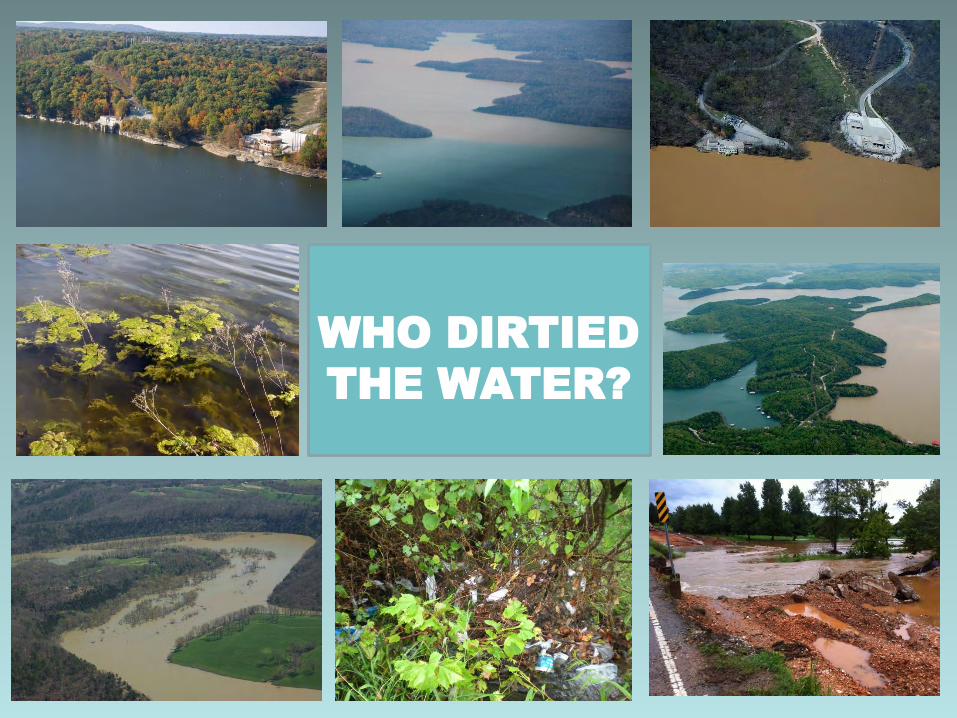
WHO DIRTIED
THE WATER?

SOURCE: littlebuffalodotcom.files.wordpress.com/2012/12/img_5000.jpg
LONG AGO IN THE BOSTON MOUNTAINS

SOURCE: littlebuffalodotcom.files.wordpress.com/2013/03/img_3143.jpg
STREAMS RAN CLEAN & CLEAR

SOURCE: littlebuffalodotcom.files.wordpress.com/2012/0
7/img_3417.jpg
SOURCE: arkarcheology.uark.edu/indiansofarkansas/printerfriendly.html?pageName=Ancient+Foodways
HICKORY NUTS WILD TURKEYS
WILDLIFE FLOURISHED
AMERICAN BLACK BEAR
SOURCE: www.arkansas.com/outdoors/birding/wildlife/bear/
SOURCE: ozarkbill.files.wordpress.com/2014/01/img_9400.jpg?w=619&h=279
AMERICAN BLACK BEAR
WHITE-TAILED DEER
SOURCE: www.agfc.com/species/Pages/SpeciesWildlifeDetails2.aspx?Title=White-tailed Deer

Would you want to swim in the river? Would you drink water from the lake? Would you eat the fish you caught there? How do you think either one would taste?

SOURCE: www.daviduhrin.com/sitebuildercontent/sitebuilderpictures/.pond/Ohio_Wetlands.jpg.w560h420.jpg
STREAMSIDE WETLANDS

SOURCE: www.naturalheritage.com/gallery/rare-animals-invertebrates/#2277
ARKANSAS FATMUCKET MUSSEL
RABBITSFOOT MUSSEL
FRESHWATER
MUSSELS

SOURCE: upload.wikimedia.org/wikipedia/commons/thumb/a/ae/Map_of_Traditional_Osage_Tribal_Lands_by_Late_17th_Century.jpg/30
0px-Map_of_Traditional_Osage_Tribal_Lands_by_Late_17th_Century.jpg
SOURCE: www.ozarkhistory.com/sonyahall.gi
f
SOURCE: arkarcheology.uark.edu/indiansofarkansas/index.html?pageName=The+Osage+Indi
ans
SOURCE: upload.wikimedia.org/wikipedia/commons/0/02/Osage_nation_seal.gi
f
OSAGE PEOPLE LIVED HERE 300 YEARS AGO

SHELL MIDDEN SOURCE:
www.nps.gov/miss/naturescience/images/midden.jpg
SOURCE: www.wvculture.org/shpo/es/lifeways.html
SOURCE: www.wvculture.org/sh
po/es/lifeways.html
OSAGE FOOD SOURCES & MIDDENS

Would you want to swim in the river? Would you drink water from the lake? Would you eat the fish you caught there? How do you think either one would taste?

SOURCE: littlebuffalodotcom.files.wordpress.com/2012/01/img_0
047_tonemapped_tonemapped.jpg SOURCE: thelibrary.org/lochist/periodicals/wrv/v1/n6/0106p12.jpg
SOURCE: www.gocolumbiamo.com/PublicWorks/StormWater/images/FlatBr
anchouthouses.jpg
ARRIVAL OF EUROPEAN SETTLERS IN THE 1800s

The Beaver Lake Watershed
encompasses over 766,026 acres or
1200 square miles. It is a sub-
watershed of the White River
Watershed which is a sub-watershed of
the Mississippi River Watershed.
SOURCE: www.mvd.usace.army.mil/portals/52/siteimages/P1_new.jpg
SOURCE: hillnholler.files.wordpress.com/2013/07/white-river-watershed.png
BEAVER LAKE BEGAN BY
BUILDING BEAVER DAM ON THE
WHITE RIVER IN THE 1960s

SOURCE: knoe.images.worldnow.com/images/
23081577_BG1.jpg
SOURCE: www.americanrivers.org/wp-content/uploads/2013/08/stormwater-
flooding.jpg
SOURCE: www.huntventures.net/ICSC.h4.gif
SOURCE: www.fayettevillenatural.org/userfiles/image/40%20MUD%20CRE
EK-JOYCE-71%20labels.JPG
1800s TO PRESENT
EXPANDING POPULATION,
PAVEMENT, & POLLUTION
PROBLEMS

Would you want to swim in the river? Would you drink water from the lake? Would you eat the fish you caught there? How do you think either one would taste?

Who dirtied the water?

ALL OF US

Who is responsible for cleaning it up?

ALL OF US
What are some ways that we can clean up
the watershed(s)?

• Community Clean-Ups • Pick up trash when we see it • Don’t litter or dump in storm drains
• Reduce-reuse-recycle

What are some ways of preventing pollution?

• Apply fertilizer as needed
• Pick-up pet waste

Why is it important to keep the water clean?

All living things need clean watershed

ACCESSIBLE FRESH WATER: A Limited Resource for a Rapidly Growing Human
Population
PROBLEMS & SOLUTIONS

U.S. & WORLD POPULATION AS OF 6:30 PM U.S. CST MONDAY/MAY 19 www.census.gov/popclock/

WORLD POPULATION GROWTH PER CONTINENT 1950-2100
SOURCE: http://graphics8.nytimes.com/images/2011/05/03/world/20110503_POPULATION_graphic/20110503_POP
ULATION_graphic-popup-v3.jpg

Estimated US per Capita Fresh Water Availability: 15000 cubic meters = 3,962,581 US Gallons Olympic Swimming Pool Dimensions: Length 50 meters or 164.042 feet x Width 25 meters or 82.021 feet x Depth
2 meters or 6.56 feet (minimum) Volume: 2,500,000 Liters = 2,500 cubic meters = 660,253.09 US Gallons
http://www.wrsc.org/attach_image/global-freshwater-availability-capita-2007

http://www.circleofblue.org/waternews/2009/cob/waterviews/waterviews-infographics/

http://www.rainbird.com/corporate/iuow/images/IUOWinfographic_md.jpg

SOURCE: www.owsc.org/Portals/12/images/quality_e.jpg
STORMWATER BEST MANAGEMENT PRACTICES & LOW IMPACT DEVELOPMENT METHODS
ARE 1st STEPS TO TAKE IN PROTECTING DRINKING WATER QUALITY

STORMWATER MANAGEMENT & LOW IMPACT DEVELOPMENT
METHODS:
• ARE 1st STEPS TO TAKE IN PROTECTING DRINKING WATER QUALITY
• TREAT RAIN WATER AS A RESOURCE NOT A WASTE PRODUCT
• WORK WITH NATURAL PROCESSES TO ALLOW RAIN WATER RUNOFF TO:
SLOW DOWN SPREAD OUT SOAK IN

RIPARIAN BUFFER ZONES (aftaweb.org)
http://archive.constantcontact.com/fs075/1102224436468/archive/1110191050621.html
OZARKS WATER WATCH NEWSLETTER June 11, 2012 Vol VI Issue 24
WHITE RIVER BANK STABILIZATION PROJECT SPRING 2012

SOURCE: www.haywood.edu/UserFiles/natural_resources_management/LIDSedimentsResidential.jpg

LID @ BWD

SOURCE: www.aucklandcity.govt.nz/council/services/stormwater/about.asp

LUNCH

Mission: Beaver Water District is a public entity whose mission is to provide our customers in Benton & Washington counties with high quality drinking water that meets or exceeds all federal and state regulatory requirements, in plentiful quantities, at an economical price.

BEAVER LAKE AND BEAVER WATER DISTRICT ORIGINS: Nearly 50 years ago, visionary community leaders got together to discuss the need for a long-term supply of clean, safe water for Northwest Arkansas. With an eye to the future and conventional understanding that a large lake was the best source of water, these citizens worked to establish Beaver Lake Reservoir.

In 1954, Congress passed a flood control act authorizing the construction of Beaver Dam across the White River in Carroll County. A groundbreaking ceremony was held on November 22, 1960, by the Beaver Dam Association. The Army Corps of Engineers began work on Beaver Dam in 1960, impounding a major part of the White River and creating Beaver Lake. Construction was completed in 1966 and the lake filled to the Operational Pool elevation of 1120 in 1968. The lake—technically a reservoir since it was created by a manmade dam in order to store water—is located on the White River in the Ozark Highlands region of northwest Arkansas. Beaver Lake is approximately 50 miles in length and covers approximately 31,700 acres, with about 449 miles of shoreline and an elevation of 1,120 feet. http://www.encyclopediaofarkansas.net/encyclopedia/entry-detail.aspx?entryID=5877
http://www.co.benton.ar.us/history.aspx
Flood Control, Water Supply, Recreation, Hydroelectric Power

http://rogersarkansas.com/museum/photo/beaverdam1.asp
BEAVER DAM CONSTRUCTION 1962-1966
http://www.rogersarkansas.com/museum/MonteNe/today.htm
During Construction
Lake Filled with Water
After Construction

BWD intake construction began on the White River
in 1960
www.bwdh2o.org

Source: http://www.bwdh2o.org/files/45/2010_FINAL_Beaver_Lake_Wate
rshed_Report.pdf Lake Surface Elevation: 1120 ft Lake Flood Surface Elevation: 1130 ft
Source: http://www.city-data.com/picfilesv/picv31371.php
The 2,575-foot-long dam consists of a 1,333-foot-long concrete section keyed into a limestone bluff, 1,242 feet of earth and rock embankment, and three small earth and rock dikes that fill gaps between adjacent hills. The spillway section is 328 feet long. Maximum height of the dam above the streambed is 228 feet. Mean depth is fifty-eight feet, and the maximum depth is 216 feet. The structure contains 780,000 cubic yards of concrete and 1.6 million yards of rock and dirt embankment. Storage capacity is 1.95 million acre-feet, which includes flood control storage. At full conservation pool, or normal managed lake level, the reservoir covers 28,200 acres with a shoreline of 449 miles. The mean hydraulic retention time (the time it takes for water to cycle through the reservoir) is one and a half years.
http://www.encyclopediaofarkansas.net/encyclopedia/entry-detail.aspx?entryID=5877
BEAVER DAM

Dot Neely/BWD Education Program Coordinator [email protected]
HOW BWD CLEANS WATER FOR DRINKING
www.bwdh2o.org

DRINKING WATER TREATMENT PROCESSES
www.bwdh2o.org
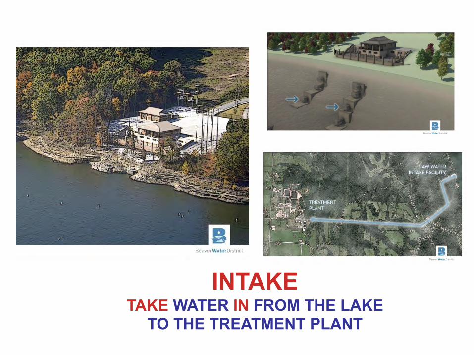
INTAKE TAKE WATER IN FROM THE LAKE
TO THE TREATMENT PLANT

COAGULATION THE COMBINING OF SMALL PARTICLES TO FORM LARGER, HEAVIER PARTICLES.
FLASH MIX & FLOC ALUM & OTHER CHEMICALS ARE ADDED TO LAKE WATER TO FORM TINY STICKY PARTICLES CALLED “FLOC,” WHICH ATTRACT DIRT TO FORM LARGER AND HEAVIER PARTICLES.
FLASH MIX
www.bwdh2o.org

FLASH MIX
SEDIMENTATION THE SINKING AND SETTLING OF
PARTICLES DOWNWARD
FLOC CLOUD
FLOW
SEDIMENT
SEDIMENTATION CHAMBERS
www.bwdh2o.org

FILTRATION PASSING OF WATER THROUGH
MATERIALS WHICH REMOVE THE SMALLEST PARTICLES
FILTER DECK
FILTER CHAMBERS
www.bwdh2o.org

DISINFECTION THE ADDITION OF CHLORINE TO
KILL BACTERIA OR MICRO-ORGANISMS
www.bwdh2o.org

STORAGE CLEARWELLS ARE BASINS FOR HOLDING
WATER BEFORE DISTRIBUTION
CLEARWELLS
CLEARWELLS
www.bwdh2o.org

DISTRIBUTION SENDING WATER TO CITY WATER UTILITIES WHICH THEN SEND IT TO YOUR
HOUSE
www.bwdh2o.org

www.bwdh2o.org


AND NOW YOU KNOW AS MUCH
AS A FROG ABOUT
DRINKING WATER
TREATMENT
www.bwdh2o.org


QUESTIONS?
www.bwdh2o.org