Embed Size (px)
Citation preview
This article was downloaded by: [Simon Fraser University]On: 18 November 2014, At: 20:13Publisher: Taylor & FrancisInforma Ltd Registered in England and Wales Registered Number: 1072954 Registered office: Mortimer House,37-41 Mortimer Street, London W1T 3JH, UK
Physical GeographyPublication details, including instructions for authors and subscription information:http://www.tandfonline.com/loi/tphy20
Spatial and Temporal Variability in FloodplainBackwater Sedimentation Pool Ten, Upper MississippiRiverLindsay J. Theis a & James C. Knox aa University of Wisconsin-MadisonPublished online: 15 May 2013.
To cite this article: Lindsay J. Theis & James C. Knox (2003) Spatial and Temporal Variability in Floodplain BackwaterSedimentation Pool Ten, Upper Mississippi River, Physical Geography, 24:4, 337-353
To link to this article: http://dx.doi.org/10.2747/0272-3646.24.4.337
PLEASE SCROLL DOWN FOR ARTICLE
Taylor & Francis makes every effort to ensure the accuracy of all the information (the “Content”) containedin the publications on our platform. However, Taylor & Francis, our agents, and our licensors make norepresentations or warranties whatsoever as to the accuracy, completeness, or suitability for any purpose of theContent. Any opinions and views expressed in this publication are the opinions and views of the authors, andare not the views of or endorsed by Taylor & Francis. The accuracy of the Content should not be relied upon andshould be independently verified with primary sources of information. Taylor and Francis shall not be liable forany losses, actions, claims, proceedings, demands, costs, expenses, damages, and other liabilities whatsoeveror howsoever caused arising directly or indirectly in connection with, in relation to or arising out of the use ofthe Content.
This article may be used for research, teaching, and private study purposes. Any substantial or systematicreproduction, redistribution, reselling, loan, sub-licensing, systematic supply, or distribution in anyform to anyone is expressly forbidden. Terms & Conditions of access and use can be found at http://www.tandfonline.com/page/terms-and-conditions
337
Physical Geography, 2003, 24, 4, pp. 337–353.Copyright © 2003 by V. H. Winston & Son, Inc. All rights reserved.
SPATIAL AND TEMPORAL VARIABILITY IN FLOODPLAIN BACKWATER SEDIMENTATION, POOL TEN, UPPER MISSISSIPPI RIVER
Lindsay J. Theis and James C. KnoxDepartment of Geography
University of Wisconsin-MadisonMadison, Wisconsin 53706
Abstract: Sedimentation in Upper Mississippi River (UMR) aquatic habitats known as “backwaters” has been an issue of concern since the installation of navigation locks and dams in the late 1930s. The impounded river subjects previously protected aquatic habitat to increased durations of river flow and associated sedimentation. Four cores were extracted from isolated backwaters in Navigation Pool Ten near Bagley, Wisconsin, in summer 2001. Particle size, organic carbon, and carbonate analyses were used to deter-mine sedimentation response to changes in flooding associated with the dams. UMR flooding heavily influences backwaters adjacent to the main channel, while backwaters more distant from the main channel have the potential to be influenced by small tributary streams. High spatial variability in sedimentation patterns of the Bagley Bottoms backwa-ters suggests the importance of relative site location when evaluating these habitats. In addition, recent large magnitude floods on the UMR seem to be a major source of back-water sediments. Therefore, potential changes in recurrence frequencies of large UMR floods and their driving forces should also be considered in evaluating the future of back-waters. [Key words: floodplain, sedimentation, Upper Mississippi River.]
INTRODUCTION
Prior to Euro-American settlement, the Upper Mississippi River floodplain was characterized by secondary channels and shallow backwaters (floodplain habitat beyond main and secondary channel banks) that were connected to main channel flow during typical high stages of spring floods, or completely dry and fragmented during typical low stage flows of late summer. Sand bars and vegetation snags were plentiful, making maintenance of a navigation channel difficult (Anfinson, 1993). Channel structures constructed in the late 19th and early 20th centuries, such as wing dams, small closing dams, and revetments increased depth and water velocity in the main channel (Anfinson, 1993). In an effort to revitalize river navigation, a series of locks and dams were installed in the late 1930s by the Army Corps of Engi-neers on the Upper Mississippi River (UMR), which extended navigable waters from St. Louis, Missouri to St. Paul, Minnesota. The locks and dams raised water levels, converting the river into a series of pools, and increased the navigation channel to a depth of nine feet. The locks and dams were vital for the survival of the barge industry, but there was much concern with the project’s influence on river functions and wildlife (Anfinson, 1993).
As the locks and dams of the UMR raised water levels, the periods in which the main river was connected with aquatic floodplain habitats or “backwater” areas
Dow
nloa
ded
by [
Sim
on F
rase
r U
nive
rsity
] at
20:
13 1
8 N
ovem
ber
2014
338 THEIS AND KNOX
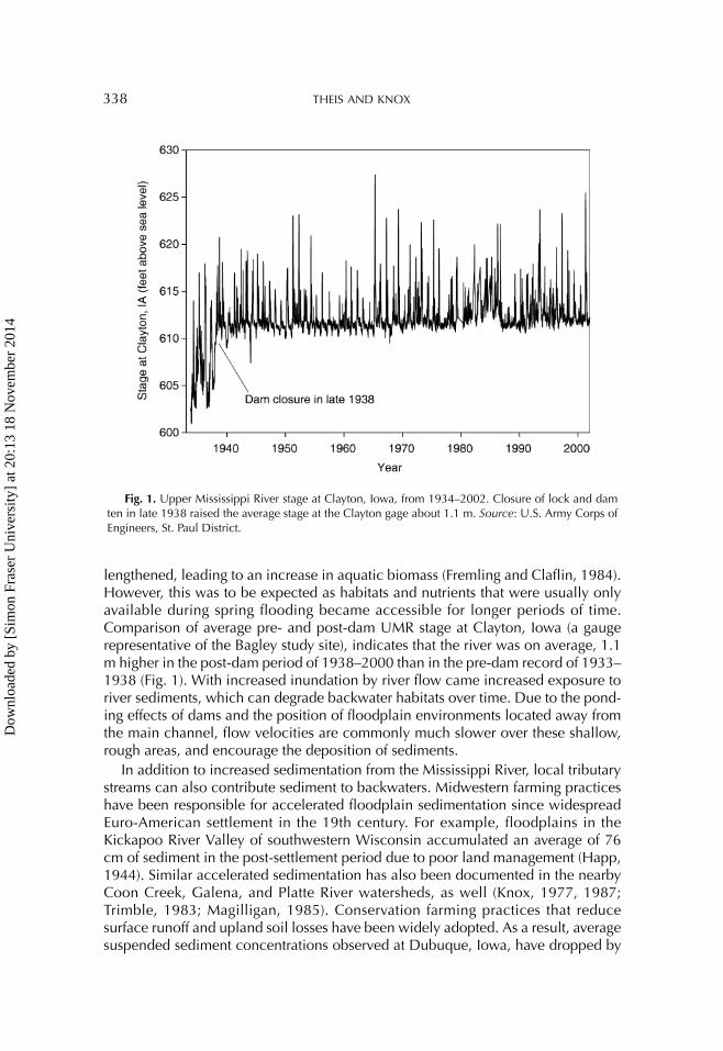
lengthened, leading to an increase in aquatic biomass (Fremling and Claflin, 1984). However, this was to be expected as habitats and nutrients that were usually only available during spring flooding became accessible for longer periods of time. Comparison of average pre- and post-dam UMR stage at Clayton, Iowa (a gauge representative of the Bagley study site), indicates that the river was on average, 1.1 m higher in the post-dam period of 1938–2000 than in the pre-dam record of 1933–1938 (Fig. 1). With increased inundation by river flow came increased exposure to river sediments, which can degrade backwater habitats over time. Due to the pond-ing effects of dams and the position of floodplain environments located away from the main channel, flow velocities are commonly much slower over these shallow, rough areas, and encourage the deposition of sediments.
In addition to increased sedimentation from the Mississippi River, local tributary streams can also contribute sediment to backwaters. Midwestern farming practices have been responsible for accelerated floodplain sedimentation since widespread Euro-American settlement in the 19th century. For example, floodplains in the Kickapoo River Valley of southwestern Wisconsin accumulated an average of 76 cm of sediment in the post-settlement period due to poor land management (Happ, 1944). Similar accelerated sedimentation has also been documented in the nearby Coon Creek, Galena, and Platte River watersheds, as well (Knox, 1977, 1987; Trimble, 1983; Magilligan, 1985). Conservation farming practices that reduce surface runoff and upland soil losses have been widely adopted. As a result, average suspended sediment concentrations observed at Dubuque, Iowa, have dropped by
Fig. 1. Upper Mississippi River stage at Clayton, Iowa, from 1934–2002. Closure of lock and dam ten in late 1938 raised the average stage at the Clayton gage about 1.1 m. Source: U.S. Army Corps of Engineers, St. Paul District.
Dow
nloa
ded
by [
Sim
on F
rase
r U
nive
rsity
] at
20:
13 1
8 N
ovem
ber
2014
BACKWATER SEDIMENTATION 339
50% since the 1940s (Pannell, 1999). Ironically, it is partly due to reduced upland soil losses, following the diffusion of conservation methods, that historically stored sediment in downstream floodplains and alluvial fans is now being remobilized by cleaner upland runoff (Trimble, 1983; Knox and Faulkner, 1994; Faulkner and McIntyre, 1996; Knox, 2001). The remobilized sediment is being transported down-stream to the UMR, maintaining sedimentation problems. Shallow backwaters and floodplain lakes may slowly turn into terrestrial habitat as floodplain areas fill with sediment and are invaded by terrestrial vegetation (Fremling and Claflin, 1984).
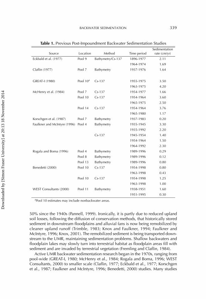
Active UMR backwater sedimentation research began in the 1970s, ranging from pool-wide (GREAT-I, 1980; McHenry et al., 1984; Rogala and Boma, 1996; WEST Consultants, 2000) to smaller scale (Claflin, 1977; Eckbald et al., 1977; Korschgen et al., 1987; Faulkner and McIntyre, 1996; Benedetti, 2000) studies. Many studies
Table 1. Previous Post-Impoundment Backwater Sedimentation Studies
Source Location Method Time periodSedimentation
rate (cm/yr)
Eckbald et al. (1977) Pool 9 Bathymetry/Cs-137 1896-1977 2.11
1964-1974 1.69
Claflin (1977) Pool 7 Bathymetry 1937-1976 1.64
GREAT-I (1980) Pool 10a Cs-137 1955-1975 3.50
1963-1975 4.20
McHenry et al. (1984) Pool 7 Cs-137 1954-1977 1.66
Pool 10 Cs-137 1954-1964 3.60
1965-1975 2.50
Pool 14 Cs-137 1954-1964 3.76
1965-1980 1.17
Korschgen et al. (1987) Pool 7 Bathymetry 1937-1983 0.20
Faulkner and McIntyre (1996) Pool 4 Bathymetry 1935-1945 3.30
1935-1992 2.20
Cs-137 1945-1954 1.40
1954-1964 1.50
1964-1992 2.30
Rogala and Boma (1996) Pool 4 Bathymetry 1989-1996 0.29
Pool 8 Bathymetry 1989-1996 0.12
Pool 13 Bathymetry 1989-1996 0.80
Benedetti (2000) Pool 10 Cs-137 1954-1998 0.80
1963-1998 0.43
Pool 10 Cs-137 1954-1998 1.25
1963-1998 1.00
WEST Consultants (2000) Pool 11 Bathymetry 1938-1951 1.60
1951-1995 0.30aPool 10 estimates may include nonbackwater areas.
Dow
nloa
ded
by [
Sim
on F
rase
r U
nive
rsity
] at
20:
13 1
8 N
ovem
ber
2014
340 THEIS AND KNOX
had the goal of estimating sedimentation rates in order to determine the severity of the sedimentation problem. Methods range from repeated bathymetry surveys to dating backwater sediment cores using the Cs-137 method. The sedimentation rates obtained by these studies ranged from fractions of 1 cm/yr to ~4 cm/yr (Table 1). With the exception of the study by Rogala and Boma (1996), the reasons behind the highly variable rates were not fully addressed. The study presented in this paper focuses on a small backwater area in southwestern Wisconsin and the spatial influ-ences on observed sedimentation, which may aid in explaining the highly variable nature of backwater sedimentation in the UMR.
STUDY AREA
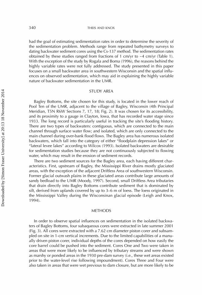
Bagley Bottoms, the site chosen for this study, is located in the lower reach of Pool Ten of the UMR, adjacent to the village of Bagley, Wisconsin (4th Principal Meridian, T5N R6W Sections 7, 17, 18; Fig. 2). It was chosen for its accessibility, and its proximity to a gauge in Clayton, Iowa, that has recorded water stage since 1933. The long record is particularly useful in tracking the site’s flooding history. There are two types of backwaters: contiguous, which are connected to the main channel through surface water flow; and isolated, which are only connected to the main channel during over-bank flood flows. The Bagley area has numerous isolated backwaters, which fall into the category of either “floodplain depression lakes” or “lateral levee lakes” according to Wilcox (1993). Isolated backwaters are desirable for sedimentation studies because they are not continuously subjected to flowing water, which may result in the erosion of sediment records.
There are two sediment sources for the Bagley area, each having different char-acteristics. First, upstream of Bagley, the Mississippi River drains mostly glaciated areas, with the exception of the adjacent Driftless Area of southwestern Wisconsin. Former glacial outwash plains in these glaciated areas contribute large amounts of sandy bedload to the UMR (Moody, 1997). Second, small Driftless Area tributaries that drain directly into Bagley Bottoms contribute sediment that is dominated by silt, derived from uplands covered by up to 3–6 m of loess. The loess originated in the Mississippi Valley during the Wisconsinan glacial episode (Leigh and Knox, 1994).
METHODS
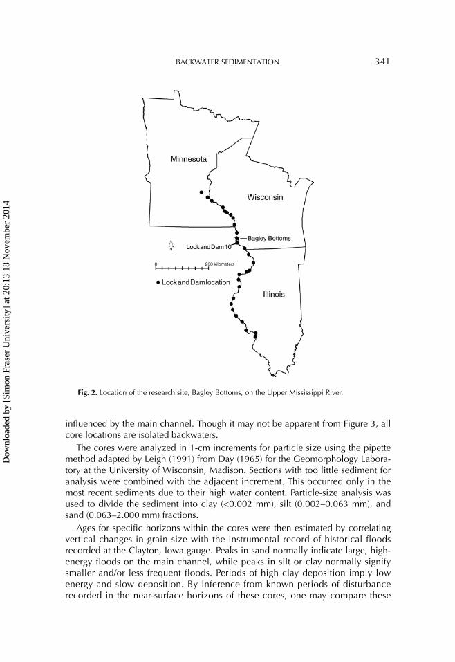
In order to observe spatial influences on sedimentation in the isolated backwa-ters of Bagley Bottoms, four subaqueous cores were extracted in late summer 2001 (Fig. 3). All cores were extracted with a 7.62 cm diameter piston corer and subsam-pled on site in 1-cm vertical increments. Due to the limited capabilities of a manu-ally driven piston corer, individual depths of the cores depended on how easily the core barrel could be pushed into the sediment. Cores One and Two were taken in areas that were more likely to be influenced by tributary streams and were shown as marshy or ponded areas in the 1930 pre-dam survey (i.e., these wet areas existed prior to the water-level rise following impoundment). Cores Three and Four were also taken in areas that were wet previous to dam closure, but are more likely to be
Dow
nloa
ded
by [
Sim
on F
rase
r U
nive
rsity
] at
20:
13 1
8 N
ovem
ber
2014
BACKWATER SEDIMENTATION 341
influenced by the main channel. Though it may not be apparent from Figure 3, all core locations are isolated backwaters.
The cores were analyzed in 1-cm increments for particle size using the pipette method adapted by Leigh (1991) from Day (1965) for the Geomorphology Labora-tory at the University of Wisconsin, Madison. Sections with too little sediment for analysis were combined with the adjacent increment. This occurred only in the most recent sediments due to their high water content. Particle-size analysis was used to divide the sediment into clay (<0.002 mm), silt (0.002–0.063 mm), and sand (0.063–2.000 mm) fractions.
Ages for specific horizons within the cores were then estimated by correlating vertical changes in grain size with the instrumental record of historical floods recorded at the Clayton, Iowa gauge. Peaks in sand normally indicate large, high-energy floods on the main channel, while peaks in silt or clay normally signify smaller and/or less frequent floods. Periods of high clay deposition imply low energy and slow deposition. By inference from known periods of disturbance recorded in the near-surface horizons of these cores, one may compare these
Fig. 2. Location of the research site, Bagley Bottoms, on the Upper Mississippi River.
Dow
nloa
ded
by [
Sim
on F
rase
r U
nive
rsity
] at
20:
13 1
8 N
ovem
ber
2014
342 THEIS AND KNOX
stratigraphic records to the stage records or to historical facts about the region to estimate ages elsewhere within the cores. Knox (1987, 2001) and Knox and Daniels (2002) have used this correlation method in a similar manner for other sites on the UMR system.
After approximate stratigraphic ages were established, organic carbon and car-bonate analyses were used to confirm the validity of these estimates. Organic car-bon content of Cores 1 and 2 was determined by the Walkley-Black method (Janitzky, 1986) and carbonate content of all cores was determined by the Chittick method (Machette, 1986). Samples were tested in 5-cm vertical increments during preliminary analyses. Any transitional sections identified during the first series of tests were then filled in with additional tests at 1-cm increments. Cs-137 counts were also obtained for seven bulk samples from Core 1 to substantiate estimates
Fig. 3. Location of the core sites and other geographic features within the Bagley Bottoms area. Map was created with data from the USGS Upper Midwest Environmental Science Center.
Dow
nloa
ded
by [
Sim
on F
rase
r U
nive
rsity
] at
20:
13 1
8 N
ovem
ber
2014
BACKWATER SEDIMENTATION 343
made from the sedimentology. The gamma spectroscopy analysis was performed at the Wisconsin State Laboratory of Hygiene.
Carbon data were useful to this study because decomposition in saturated wet-land soils is slow, causing organic matter to accumulate. Therefore, organic carbon data were used to help determine the stratigraphic horizon designating closure of Lock and Dam 10, based on the hypothesis that carbon content should increase as areas that were previously drier became more extensive wetlands. The presence of carbonates, specifically calcite and dolomite, can be useful for indicating sediment source and the depositional history of a study site located in the UMR valley as well (Knox, 1987). Sediments from the adjacent tributary streams include a strong com-ponent derived from carbonate bedrock that underlies the extensive local uplands and unleached loess that covers the area, while Upper Mississippi River sediments have a stronger component derived from glacial material with higher quartz and feldspar mineralogies. Therefore, higher carbonate content is expected for the post-dam period when base levels rose for tributary streams, preventing easy drainage of their water and sediments from the Bagley Bottoms area.
Bulk density analysis was performed to account for sediment compaction or dis-persion when calculating sedimentation rates. Duplicate cores from the sites of Cores One and Four were subsampled at four intervals throughout the cores. The subsamples were analyzed using the clod method (Singer, 1986) to obtain wet bulk density values. Bulk density was estimated for the entire lengths of Cores One, Two, and Four by linear interpolation using a linear regression equation based on the val-ues from the replicate cores. Core One bulk density values were applied to Core Two because Core Two did not have a replicate, and the core sites had similar phys-ical settings. Bulk density values were not extrapolated to Core Three, and sedimen-tation rates were not estimated because it was not clear if the core had captured the entire 2001 flood.
Sedimentation rates were calculated in two ways. The first method was simply to divide the length of the core by the time span in which the sediments were depos-ited, resulting in a sedimentation rate in centimeters per year (cm/yr). The second method incorporated the bulk density values by multiplying the interpolated bulk density of each 1-cm increment by the volume of the respective core for a 1-cm slice (45.60 cm3). The result is the mass of sediment (in grams) per 1-cm length of core. The masses for each centimeter were summed, divided by the core area and time span in which the sediments were deposited to produce a mass accumulation rate in grams per centimeter squared per year (g/cm2/yr). This method reduces the influence of compaction on the estimation of sedimentation accumulation rates by accounting for changes in bulk density through the core.
RESULTS AND DISCUSSION
Influence of the Main Channel
The influence of location in relation to the main channel is illustrated when par-ticle size, organic carbon, and carbonate data are combined. The sites of Cores One and Two, which represent environments more distant from the main channel, have
Dow
nloa
ded
by [
Sim
on F
rase
r U
nive
rsity
] at
20:
13 1
8 N
ovem
ber
2014
344 THEIS AND KNOX
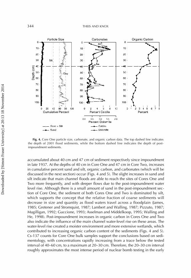
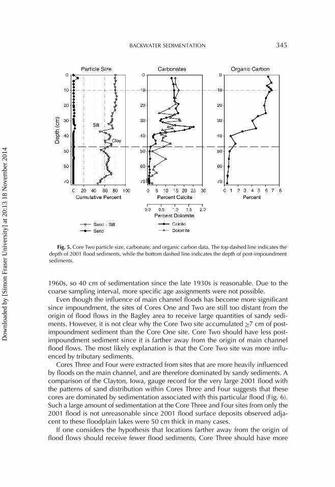
accumulated about 40 cm and 47 cm of sediment respectively since impoundment in late 1937. At the depths of 40 cm in Core One and 47 cm in Core Two, increases in cumulative percent sand and silt, organic carbon, and carbonates (which will be discussed in the next section) occur (Figs. 4 and 5). The slight increases in sand and silt indicate that main channel floods are able to reach the sites of Cores One and Two more frequently, and with deeper flows due to the post-impoundment water level rise. Although there is a small amount of sand in the post-impoundment sec-tion of Core One, the sediment of both Cores One and Two is dominated by silt, which supports the concept that the relative fraction of coarse sediments will decrease in size and quantity as flood waters travel across a floodplain (James, 1985; Gretener and Stromquist, 1987; Lambert and Walling, 1987; Pizzuto, 1987; Magilligan, 1992; Guccione, 1993; Asselman and Middelkoop, 1995; Walling and He, 1998). Post-impoundment increases in organic carbon in Cores One and Two also indicate the influence of the main channel water-level rise on these areas. The water-level rise created a moister environment and more extensive wetlands, which contributed to increasing organic carbon content of the sediments (Figs. 4 and 5). Cs-137 counts for Core One bulk samples support the conclusions based on sedi-mentology, with concentrations rapidly increasing from a trace below the tested interval of 40–60 cm, to a maximum at 20–30 cm. Therefore, the 20–30 cm interval roughly approximates the most intense period of nuclear bomb testing in the early
Fig. 4. Core One particle size, carbonate, and organic carbon data. The top dashed line indicates the depth of 2001 flood sediments, while the bottom dashed line indicates the depth of post-impoundment sediments.
Dow
nloa
ded
by [
Sim
on F
rase
r U
nive
rsity
] at
20:
13 1
8 N
ovem
ber
2014
BACKWATER SEDIMENTATION 345
1960s, so 40 cm of sedimentation since the late 1930s is reasonable. Due to the coarse sampling interval, more specific age assignments were not possible.
Even though the influence of main channel floods has become more significant since impoundment, the sites of Cores One and Two are still too distant from the origin of flood flows in the Bagley area to receive large quantities of sandy sedi-ments. However, it is not clear why the Core Two site accumulated >7 cm of post-impoundment sediment than the Core One site. Core Two should have less post-impoundment sediment since it is farther away from the origin of main channel flood flows. The most likely explanation is that the Core Two site was more influ-enced by tributary sediments.
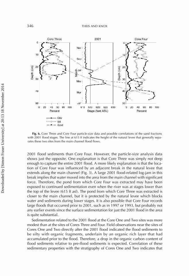
Cores Three and Four were extracted from sites that are more heavily influenced by floods on the main channel, and are therefore dominated by sandy sediments. A comparison of the Clayton, Iowa, gauge record for the very large 2001 flood with the patterns of sand distribution within Cores Three and Four suggests that these cores are dominated by sedimentation associated with this particular flood (Fig. 6). Such a large amount of sedimentation at the Core Three and Four sites from only the 2001 flood is not unreasonable since 2001 flood surface deposits observed adja-cent to these floodplain lakes were 50 cm thick in many cases.
If one considers the hypothesis that locations farther away from the origin of flood flows should receive fewer flood sediments, Core Three should have more
Fig. 5. Core Two particle size, carbonate, and organic carbon data. The top dashed line indicates the depth of 2001 flood sediments, while the bottom dashed line indicates the depth of post-impoundment sediments.
Dow
nloa
ded
by [
Sim
on F
rase
r U
nive
rsity
] at
20:
13 1
8 N
ovem
ber
2014
346 THEIS AND KNOX
2001 flood sediments than Core Four. However, the particle-size analysis data shows just the opposite. One explanation is that Core Three was simply not deep enough to capture the entire 2001 flood. A more likely explanation is that the loca-tion of Core Four was influenced by an adjacent break in the natural levee that extends along the main channel (Fig. 3). A large 2001 flood-related log-jam in this break implies that water moved into the area from the main channel with significant force. Therefore, the pond from which Core Four was extracted may have been exposed to continued sedimentation even when the river was at stages lower than the top of the levee (615 ft asl). The pond from which Core Three was extracted is closer to the main channel, but it is protected by the natural levee which blocks water and sediments during lower stages. It is also possible that Core Four records large floods that occurred prior to 2001, such as in 1997 or 1993, but probably not any earlier events since the surface sedimentation for just the 2001 flood in the area is quite substantial.
Sedimentation related to the 2001 flood at the Core One and Two sites was more modest than at the sites of Cores Three and Four. Field observations near the sites of Cores One and Two directly after the 2001 flood indicated the flood sediments to be silty with organic fragments, underlain by an organic rich layer that had accumulated prior to the flood. Therefore, a drop in the organic carbon content of flood sediments relative to pre-flood sediments is expected. Correlation of these sedimentary properties with the stratigraphy of Cores One and Two indicates that
Fig. 6. Core Three and Core Four particle-size data and possible correlations of the sand fractions with 2001 flood stages. The line at 615 ft indicates the height of the natural levee that generally sepa-rates these two sites from the main channel flood flows.
Dow
nloa
ded
by [
Sim
on F
rase
r U
nive
rsity
] at
20:
13 1
8 N
ovem
ber
2014
BACKWATER SEDIMENTATION 347
Core One accumulated about 12 cm of sediment, and Core Two accumulated about 10 cm of sediment during the 2001 flood. These amounts lie within or close to the range of 6 to 10 cm of deposition observed at six sites on a higher surface of the floodplain adjacent to the site of Core One. Since Core Two is slightly farther away from the primary pathway of flood flows than the Core One site, its modestly lower sedimentation for the 2001 flood is expected.
Combining particle size and organic carbon data proved to be useful in deter-mining the influence of the main channel UMR on the Bagley Bottoms backwaters. As one might expect, backwaters farther away from the main channel are influ-enced to a lesser extent by main channel floods. However, the individual settings of the sampling sites are still important to consider.
Influence of Tributary Streams
Tributary streams that drain into the Bagley floodplain area near the sites of Cores One and Two, such as Gasner Hollow and Ready Hollow, experienced a base level rise after the creation of Pool 10. The streams now drain into what may be standing water for much of the year, causing sediment being carried by the streams to be deposited in the adjacent backwaters instead of being carried out to the main chan-nel. These tributary streams drain uplands that are underlain by dolomite bedrock and capped by loess that contribute sediments higher in carbonates than sediments associated with the main channel UMR. Therefore, it was postulated that an increase in carbonates would indicate greater input of sediments from tributary streams.
Core One and Core Two dolomite content increases slightly in the post-impoundment record, so tributary sediments are probably settling out in this area more frequently than in the pre-impoundment period as hypothesized (Figs. 4 and 5). Calcite content increases in both Cores One and Two after impoundment, but these amounts are not always in-phase with dolomite variations and are probably too high to suggest that the unleached loess component of tributary sediments are the only source of calcite, especially in Core Two (Figs. 4 and 5). The formation of secondary carbonate may explain the discrepancy. As previously mentioned, the post-impoundment water rise created more extensive wetlands in the Bagley area and with the creation of this environment, aquatic vegetation probably became more common. High levels of photosynthesis by abundant aquatic vegetation removes carbon dioxide from water, which increases water pH. Calcium carbonate is less soluble at higher pH levels and over-saturation will cause precipitation (Horne and Goldman, 1994). Although the water chemistry of the Bagley area is not known, macrophytes were abundant and dense at the Core One and Core Two sites, so it is possible that much of the post-impoundment increase in calcite is sec-ondary.
The formation of secondary carbonate also supports the evidence for 2001 flood sedimentation based on organic carbon content. For example, organic carbon and calcite both drop at about 12 cm depth in Core One, indicating that the recently deposited sediments were not in the backwater environment long enough to build up organics or secondary carbonates. The large volume of flood waters may have
Dow
nloa
ded
by [
Sim
on F
rase
r U
nive
rsity
] at
20:
13 1
8 N
ovem
ber
2014
348 THEIS AND KNOX
also discouraged secondary carbonate formation in general. Although the decrease is not as dramatic as in Core One, Core Two calcite content decreases slightly along with organic carbon above 10 cm depth (the previously hypothesized depth of 2001 flood sediments). Lastly, Cores Three and Four contained only traces of calcite and dolomite (the maximum value was 0.4%), which indicates that tributary sedi-ments have little influence at these sites and the cores probably contain only 2001 flood sediments.
Sedimentation Rates
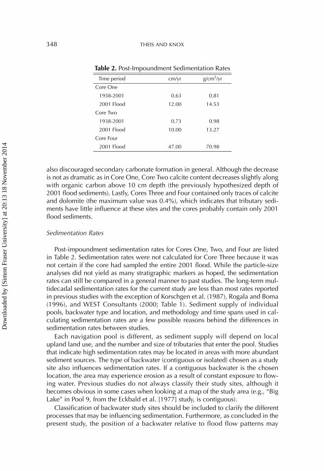
Post-impoundment sedimentation rates for Cores One, Two, and Four are listed in Table 2. Sedimentation rates were not calculated for Core Three because it was not certain if the core had sampled the entire 2001 flood. While the particle-size analyses did not yield as many stratigraphic markers as hoped, the sedimentation rates can still be compared in a general manner to past studies. The long-term mul-tidecadal sedimentation rates for the current study are less than most rates reported in previous studies with the exception of Korschgen et al. (1987), Rogala and Boma (1996), and WEST Consultants (2000; Table 1). Sediment supply of individual pools, backwater type and location, and methodology and time spans used in cal-culating sedimentation rates are a few possible reasons behind the differences in sedimentation rates between studies.
Each navigation pool is different, as sediment supply will depend on local upland land use, and the number and size of tributaries that enter the pool. Studies that indicate high sedimentation rates may be located in areas with more abundant sediment sources. The type of backwater (contiguous or isolated) chosen as a study site also influences sedimentation rates. If a contiguous backwater is the chosen location, the area may experience erosion as a result of constant exposure to flow-ing water. Previous studies do not always classify their study sites, although it becomes obvious in some cases when looking at a map of the study area (e.g., “Big Lake” in Pool 9, from the Eckbald et al. [1977] study, is contiguous).
Classification of backwater study sites should be included to clarify the different processes that may be influencing sedimentation. Furthermore, as concluded in the present study, the position of a backwater relative to flood flow patterns may
Table 2. Post-Impoundment Sedimentation Rates
Time period cm/yr g/cm2/yr
Core One
1938-2001 0.63 0.81
2001 Flood 12.00 14.53
Core Two
1938-2001 0.73 0.98
2001 Flood 10.00 13.27
Core Four
2001 Flood 47.00 70.98
Dow
nloa
ded
by [
Sim
on F
rase
r U
nive
rsity
] at
20:
13 1
8 N
ovem
ber
2014
BACKWATER SEDIMENTATION 349
influence sedimentation: If backwaters are adjacent to the main channel and in a position likely to receive bedload sediments, they will most likely accumulate more sediments during floods. However, if only fine-grained sediments are deposited, net sedimentation may be less due to resuspension that may occur from flow currents during slowly receding flood waters or wind-produced wave action. Rogala and Boma (1996) also acknowledged that location is important with their intensive resurveying of bathymetry transects in Pools 4, 8, and 13.
It is frequently unclear whether methodologies for many previous studies accounted for possible vertical variations in bulk density when determining sedi-mentation rates since the data are reported in centimeters per year. For example, 1 cm of watery organic sediments, or gyttja, does not equal 1 cm of solid mineral matter—the centimeter of solid mineral matter represents more accumulation even though the gyttja occupies the same amount of space. Therefore, reporting sedi-mentation as mass accumulation rates (g/cm2/yr) may be more accurate. If the area of a backwater is known, mass accumulation rates could be extrapolated to the whole backwater with spatially intensive sediment sampling.
Lastly, the time span used in calculating sedimentation rates may influence con-clusions. The large amounts of sediment deposited in Bagley Bottoms during the 2001 flood indicate that large magnitude floods can be a very important source of sediments in backwaters. For example, the 2001 flood sediments make up 30% of post-impoundment sediments in Core One at their present density. If a chosen time period has a high incidence of large floods, the sedimentation rate will be higher in comparison to time periods with lesser magnitude floods. Knox (1999) showed that several large floods dominated long-term floodplain sedimentation rates for the Little Platte River in southwestern Wisconsin, and because of computation method-ology, sedimentation rates tend to decrease as the time interval lengthens. The issues of bulk density and time scale brings into question the validity of using vari-able time-averaged sedimentation rates in evaluating the state of backwater habi-tats. Unless sedimentation rates can be calibrated to reflect sediment compaction and changes in flood magnitude and frequency during the study time period, they may not be presenting an accurate picture.
CONCLUSION
There is still much to be observed and understood regarding backwater sedimen-tation. The UMR is a large system, with many different backwater habitat scenarios that could be investigated. The results from Bagley Bottoms indicate that particle-size analysis, when performed in detailed increments, can provide a high-resolution sedimentation history, including temporal variations in sediment sources. When combined with organic carbon and carbonate analyses, particle-size analysis also provides reliable evidence for documenting sedimentation trends (which can be confirmed with Cs-137 or other isotopes such as Pb-210).
Sedimentological differences between near-channel and remote isolated back-waters at the Bagley site showed that particle-size analysis was successful in affirm-ing the importance of location on the type and amount of sediment that is deposited. By comparing particle-size data from Cores Three and Four to the 2001
Dow
nloa
ded
by [
Sim
on F
rase
r U
nive
rsity
] at
20:
13 1
8 N
ovem
ber
2014
350 THEIS AND KNOX
flood stage record at Clayton, IA, it was determined that these core locations received at least 30 to 47 cm of predominantly sandy sediments from the 2001 flood. Cores One and Two, which were located downstream of the flood flow ori-gin, received 10 to 12 cm of finer grained sediments. Thus the hypothesis from prior research that sediments decrease in size and quantity away from the main channel was supported.
Long-term sedimentation rates in Bagley Bottoms were less than reported in many previous studies for the Upper Mississippi River. Differences in sedimentation rates among backwater studies in general may be a result of numerous factors, such as the sediment supply of individual pools, backwater type and location, and meth-odology and time spans used in calculating sedimentation rates. Therefore, extrap-olation of sedimentation rates to large areas over short time spans should be done with considerable caution. Consistency in selection of sampling sites (isolated vs. contiguous backwaters), and consideration of spatial influences (distance to the main channel and/or tributary streams) should be included in future research where sedimentation surveys of large areas are needed.
The future of individual backwaters in the UMR is highly variable. General solu-tions to sedimentation problems are very difficult to formulate. Many biologists and ecologists have suggested that the naturalization of the UMR flow regime should include a summer draw-down period (Bayley, 1995; Sparks, 1995; Sparks et al., 1998). Summer draw-downs are created by lowering managed navigation pool ele-vations to simulate a natural summer low flow period. Low flow periods reduce sediment input to backwaters and allow many types of aquatic plants to germinate. Manual summer draw-downs have already been successfully attempted in Pool 8 (Anonymous, 2001).
Nevertheless, long-term solutions to alleviate problems related to backwater sed-imentation will require more than regulation of summer low flow periods because backwater sedimentation is strongly linked to the occurrences of large floods. Sed-iment sources and sinks may reach some sort of equilibrium in the future, but the UMR as a whole may not. High magnitude floods on the UMR have become more common since about 1950, and they appear to be related in part to changes in hemispheric scale patterns of atmospheric circulation associated with global warm-ing (Knox, 2000). If this speculation is correct, then relatively frequent large floods might also be anticipated for the coming decades of the 21st century. Although upland soil conservation will always be important, the possibilities for changes in climate, and subsequent changes in magnitude and frequencies of floods, suggest that potential scenarios of environmental change should also be incorporated in planning and policy procedures for the future of Upper Mississippi River floodplain habitats.
Acknowledgments: This research was supported in part by the National Science Foundation Earth System History Program, Award No. ATM-0112614. The UW-Madison Department of Geography also provided support through a Graduate Research Award. Thank you to the McGregor District of the Upper Mississippi River Fish and Wildlife Refuge, especially Clyde Male, for use of their air boat and field work assistance; Faith Fitzpatrick of the USGS for use of coring equipment and field work assistance; Kevin Spigel and Ryan Galt of the University of Wisconsin–Madison Geography Department for field work
Dow
nloa
ded
by [
Sim
on F
rase
r U
nive
rsity
] at
20:
13 1
8 N
ovem
ber
2014
BACKWATER SEDIMENTATION 351
assistance. The constructive advice of M. J. Guccione and an anonymous reviewer was much appreci-ated.
REFERENCES
Anfinson, J. O. (1993) Commerce and conservation on the Upper Mississippi River. The Annals of Iowa, Vol. 52, 385–417.
Anonymous. (2001) Pool 8 drawdown. Big River, November/December, 20–21.Asselman, N. E. M. and Middelkoop, H. (1995) Floodplain sedimentation: Quanti-
ties, patterns, and processes. Earth Surface Processes and Landforms, Vol. 20, 481–499.
Bayley, P. B. (1995) Understanding large river-floodplain ecosystems. Bioscience, Vol. 45, 153–158.
Benedetti, M. M. (2000) Recent Floods and Sediment Transport on the Upper Mississippi River. Unpublished Ph.D. dissertation, Department of Geography, University of Wisconsin, Madison, Wisconsin.
Claflin, T. O. (1977) Lake Onalaska Rehabilitation Feasibility Study Project Report. LaCrosse, WI: UW-Lacrosse River Studies Center.
Day, P. R. (1965) Particle fractionation and particle size analysis. In C. A. Black, ed., Methods of Soil Analysis, Part I. Madison, WI: American Society of Agronomy, Inc., Soil Science Society of America, Inc., 545–567.
Eckbald, J. W., Peterson, N. L., and Ostlie, K. (1977) The morphometry, benthos, and sedimentation rates of a floodplain lake in pool 9 of the Upper Mississippi River. American Midland Naturalist, Vol. 97, 433–443.
Faulkner, D. and McIntyre, S. (1996) Persisting sediment yields and sediment deliv-ery changes. Water Resources Bulletin, Vol. 32, 817–829.
Fremling, C. R. and Claflin, T. O. (1984) Ecological history of the Upper Mississippi River. In J. G. Weinener, R. V. Anderson, and D. R. McConville, eds., Contami-nants in the Upper Mississippi River: Proceedings of the 15th Annual Meeting of the Mississippi River Consortium. Boston, MA: Butterworth, 5–24.
GREAT-I (Great River Environmental Action Team). (1980) GREAT-I Study of the Upper Mississippi River, Vol. 4, Technical Appendix (g) Sediment and Erosion. St. Paul, MN: U.S. Army Corps of Engineers.
Gretener, B. and Stromquist, L. (1987) Overbank sedimentation of fine grained sed-iments: A study of the recent deposition in the Lower River Fryisan. Geografiska Annaler, Vol. 69A, 139–146.
Guccione, M. J. (1993) Grain-size distribution of overbank sediment and its use to locate channel positions. Alluvial Sedimentation: Special Publication of the Inter-national Association of Sedimentologists, Vol. 17, 185–194.
Happ, S. C. (1944) Effect of sedimentation on floods in Wisconsin. Journal of Geol-ogy, Vol. 52, 53–68.
Horne, A. J. and Goldman, C. R. (1994) Limnology. New York, NY: McGraw-Hill.James, C. S. (1985) Sediment transfer to overbank sections. Journal of Hydraulic
Research, Vol. 23, 435–452.
Dow
nloa
ded
by [
Sim
on F
rase
r U
nive
rsity
] at
20:
13 1
8 N
ovem
ber
2014
352 THEIS AND KNOX
Janitzky, P. (1986) Organic carbon (Walkley-Black Method). In M. J. Singer and P. Janitzky, eds., Field and Laboratory Procedures Used in a Soil Chronosequence Study. Denver, CO: United States Geological Survey, USGS Bulletin 1648, 11–16.
Knox, J. C. (1977) Human impacts on Wisconsin stream channels. Annals of the Association of American Geographers, Vol. 67, 323–342.
Knox, J. C. (1987) Valley floor sedimentation in the Upper Mississippi Valley. Annals of the Association of American Geographers, Vol. 77, 224–244.
Knox, J. C. (1999) Episodic changes in magnitudes and frequencies of floods. In A. G. Brown and T. A. Quine, eds., Fluvial Processes and Environmental Change. New York, NY: John Wiley and Sons, 255–282.
Knox, J. C. (2000) Sensitivity of modern and Holocene floods to climate change. Quaternary Science Reviews, Vol. 19, 439–457.
Knox, J. C. (2001) Agricultural influence on landscape sensitivity in the Upper Mississippi River Valley. Catena, Vol. 42, 193–224.
Knox, J. C. and Daniels, M. (2002) Watershed scale and the stratigraphic record of large floods. In P. K. House, D. R. Levish, R. H. Webb, and V. R. Baker, eds., Ancient Floods, Modern Hazards: Principles and Applications of Paleoflood Hydrology. Washington, DC: American Geophysical Union, 237–255.
Knox, J. C. and Faulkner, D. J. (1994) Post-Settlement Erosion and Sedimentation in the Lower Buffalo River Watershed. Unpublished final report to the western dis-trict of the Wisconsin Department of Natural Resources.
Korschgen, C. E., Jackson, G. A., Muessig, L. F., and Southworth, D. C. (1987) Sed-imentation in Lake Onalaska, navigation pool 7, Upper Mississippi River, since impoundment. Water Resources Bulletin, Vol. 23, 221–226.
Lambert, C. P. and Walling, D. E. (1987) Floodplain sedimentation: A preliminary investigation of contemporary deposition within the lower reaches of the River Culm, Devon, UK. Geografiska Annaler, Vol. 69A, 47–59.
Leigh, D. S. (1991) Origin and Paleoenviroment of the Upper Mississippi River Val-ley Roxana Silt. Unpublished Ph.D. dissertation, Department of Geography, Uni-versity of Wisconsin, Madison, Wisconsin.
Leigh, D. S. and Knox, J. C. (1994) Loess of the Upper Mississippi Valley driftless area. Quaternary Research, Vol. 42, 30–40.
McHenry, J. R., Ritchie, J. C., Cooper, C. M., and Verdon, J. (1984) Recent rates of sedimentation in the Mississippi River. In J. G. Weinener, R. V. Anderson, and D. R. McConville, eds., Contaminants in the Upper Mississippi River: Proceedings of the 15th Annual Meeting of the Mississippi River Consortium. Boston, MA: Butterworth, 5–24.
Machette, M. (1986) Calcium and magnesium carbonates. In M. J. Singer and P. Janitzky, eds., Field and Laboratory Procedures Used in a Soil Chronosequence Study. Denver, CO: United States Geological Survey, USGS Bulletin 1648, 30–33.
Magilligan, F. J. (1985) Historical floodplain sedimentation in the Galena River basin, Wisconsin and Illinois. Annals of the Association of American Geogra-phers, Vol. 75, 583–594.
Magilligan, F. J. (1992) Sedimentology of a fine-grained aggrading floodplain. Geo-morphology, Vol. 4, 393–408.
Dow
nloa
ded
by [
Sim
on F
rase
r U
nive
rsity
] at
20:
13 1
8 N
ovem
ber
2014
BACKWATER SEDIMENTATION 353
Moody, J. A. (1997) Hydrologic, Sedimentologic, and Chemical Data Describing Surficial Bed Sediments and Water in the Navigation Pools of the Upper Mississippi River, July 1991–April 1992. Denver, CO: United States Geological Survey, USGS Report 95-708.
Pannell, R. P. R. (1999) Sediment Response to Large Scale Environmental Change: The Upper Mississippi River, 1943–1996. Unpublished master’s thesis, Depart-ment of Geography, University of Wisconsin, Madison, Wisconsin.
Pizzuto, J. E. (1987) Sediment diffusion during overbank flow. Sedimentology, Vol. 34, 301–317.
Rogala, J. T. and Boma, P. J. (1996) Rates of Sedimentation along Selected Backwa-ter Transects in Pools 4, 8, and 13 of the Upper Mississippi River. Onalaska, WI: USGS Environmental Management Technical Center, LTRMP Report No. 96-T005.
Singer, M. J. (1986) Bulk Density Paraffin Clod Method. In M. J. Singer and P. Janitzky, eds., Field and Laboratory Procedures Used in a Soil Chronosequence Study. Denver, CO: United States Geological Survey, USGS Bulletin 1648, 18–19.
Sparks, R. E. (1995) Need for ecosystem management of large rivers and their flood-plains. Bioscience, Vol. 45, 168–182.
Sparks, R. E., Nelson, J. C., and Yin, Y. (1998) Naturalization of the flood regime in regulated rivers. Bioscience, Vol. 48, 706–720.
Trimble, S. W. (1983) A sediment budget for Coon Creek basin in the Driftless Area, Wisconsin, 1853–1977. American Journal of Science, Vol. 283, 454–474.
Walling, D. E. and He, Q. (1998) The spatial variability of overbank sedimentation on river floodplains. Geomorphology, Vol. 24, 209–223.
WEST Consultants. (2000) Final Report: Upper Mississippi River and Illinois Water-way Cumulative Effects Study. Volume 1: Geomorphic Assessment. Rock Island, IL: Army Corps of Engineers, Rock Island District.
Wilcox, D. B. (1993) An Aquatic Habitat Classification System for the Upper Missis-sippi River System. Onalaska, WI: Environmental Management Technical Center, Report No. 93-T003.
Dow
nloa
ded
by [
Sim
on F
rase
r U
nive
rsity
] at
20:
13 1
8 N
ovem
ber
2014