Embed Size (px)
Citation preview
Spatial Data Infrastructures in Finland: State of play 2010
SPATIAL APPLICATIONS DIVISION K.U.LEUVEN RESEARCH & DEVELOPMENT
Celestijnenlaan 200 E, BE-3001 LEUVEN TEL.: 32 16 32 97 32 FAX: 32 16 32 97 24 URL: http://www.sadl.kuleuven.be

Report meta-information
Title Spatial Data Infrastructures in Finland: State of Play 2010
Creator Danny Vandenbroucke & Dimitrios Biliouris (SADL)
Date Issued 2010-09-01
Subject INSPIRE State of Play
Publisher K.U.Leuven (SADL + ICRI)
Description This report is summarizing the review of SDI in Finland
Contributor Danny Vandenbroucke & Dimitrios Biliouris (SADL), Katleen Janssen (ICRI), Joep Crompvoets (OE)
Contributor Margaret Hall (Independent Consultant); Jos Van Orshoven, Catharina Bamps, Danny Vandenbroucke (SADL); Peter Beusen, Katleen Janssen (ICRI); Antti Vertanen, Reino Ruotsalainen, Yrjö Sucksdorff, Riitta Teiniranta (FI)
Format MS Word 97/2000
Audience INSPIRE stakeholders
Identifier rcr09FIv111.doc
Language EN
Coverage Autumn 2009 – Spring 2010
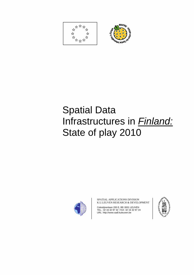
Version number Date Modified by Comments 1.0 2002-10-31 Margaret Hall & Peter
Beusen (ICRI) First version
2.0 2002-12-19 Margaret Hall Second version based on new template
3.0 2002-12-20 Jos Van Orshoven (SADL)
Completion & harmonization with 31 other country reports
4.0 2003-07-25 Margaret Hall Use of improved outline. Integration of completing and correcting remarks from Antti Vertanen (Finnish Ministry of Agriculture and Forestry), Reino Ruotsalainen (National Land Survey of Finland) and Yrjö Sucksdorff and Riitta Teiniranta (Finnish Environment Institute)
5.0 2003-08-25 Jos Van Orshoven (SADL)
Harmonisation with 31 other country reports
6.0 2004-06-18 Catharina Bamps (SADL)
Integration of information from limited review of web sites
General review, correction and update Addition of table pointing to changes with regard to Version 5.
7.0 2004-06-21 Katleen Janssen (ICRI) General review, correction and update of legal framework
8.0 2004-06-30 Jos Van Orshoven (SADL)
Consolidation
9.0 2005-06-21 Antti Vertanen Review of the status of 2005 9.1 2005-08-09 Danny Vandenbroucke Review of the 2005 update and
consolidation 9.2 2005-08-10 Katleen Janssen (ICRI) General review, correction and
update of legal framework 9.3 2005-09-23 Danny Vandenbroucke Final Report based on minor
comments from Commission 10.0 2006-12-22 Katleen Janssen (ICRI) General review, correction and
update of legal framework 10.1 2006-12-28 Danny Vandenbroucke Review of the 2006 update and
consolidation 10.0 2008-03-28 Katleen Janssen (ICRI) Correction and update legal and
organizational framework
10.1 2008-04-08 Danny Vandenbroucke, Ludo Engelen (SADL)
Integration results survey
10.2 2008-06-20 Danny Vandenbroucke (SADL)
Metadata and final changes
11.0 2010-03-25 Dimitrios Biliouris (SADL)
Review of the 2009 update
11.1 2010-06-17 Katleen Janssen (ICRI) Review of the legal framework

EC-INSPIRE: Spatial Data Infrastructures in Europe: State of play Spring 2010 Finland
K.U.Leuven (SADL) 4
Change matrix 2010 versus 2007
A concise graph is added to indicate changes of the various paragraphs compared to the previous report. Two colours are used: Green and Yellow indicating major and minimum changes respectively compared with the 2007 State of Play. This graph does not reflect the country situation. Merely it represents our findings/changes per section on our preparation of the desktop analysis
Them
atic
En
viro
nmen
tal D
ata Coordination
Organization
National
GeoportalUse
&
Efficien
cy of
the N
SDI
Network Sevices
Data of the IN
SPIRE
annexes
Metadata
Standa
rds
EC-INSPIRE: Spatial Data Infrastructures in Europe: State of play Spring 2010 Finland
K.U.Leuven (SADL) 5
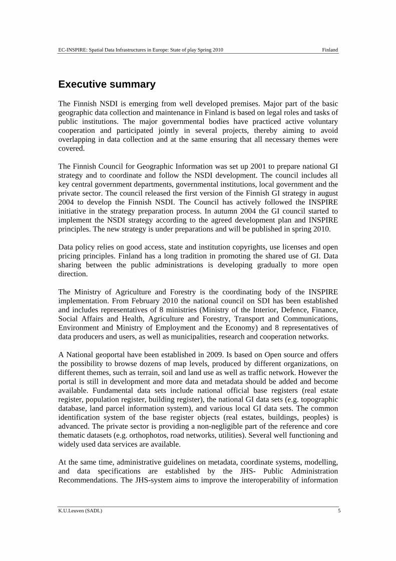
Executive summary
The Finnish NSDI is emerging from well developed premises. Major part of the basic geographic data collection and maintenance in Finland is based on legal roles and tasks of public institutions. The major governmental bodies have practiced active voluntary cooperation and participated jointly in several projects, thereby aiming to avoid overlapping in data collection and at the same ensuring that all necessary themes were covered.
The Finnish Council for Geographic Information was set up 2001 to prepare national GI strategy and to coordinate and follow the NSDI development. The council includes all key central government departments, governmental institutions, local government and the private sector. The council released the first version of the Finnish GI strategy in august 2004 to develop the Finnish NSDI. The Council has actively followed the INSPIRE initiative in the strategy preparation process. In autumn 2004 the GI council started to implement the NSDI strategy according to the agreed development plan and INSPIRE principles. The new strategy is under preparations and will be published in spring 2010.
Data policy relies on good access, state and institution copyrights, use licenses and open pricing principles. Finland has a long tradition in promoting the shared use of GI. Data sharing between the public administrations is developing gradually to more open direction.
The Ministry of Agriculture and Forestry is the coordinating body of the INSPIRE implementation. From February 2010 the national council on SDI has been established and includes representatives of 8 ministries (Ministry of the Interior, Defence, Finance, Social Affairs and Health, Agriculture and Forestry, Transport and Communications, Environment and Ministry of Employment and the Economy) and 8 representatives of data producers and users, as well as municipalities, research and cooperation networks.
A National geoportal have been established in 2009. Is based on Open source and offers the possibility to browse dozens of map levels, produced by different organizations, on different themes, such as terrain, soil and land use as well as traffic network. However the portal is still in development and more data and metadata should be added and become available. Fundamental data sets include national official base registers (real estate register, population register, building register), the national GI data sets (e.g. topographic database, land parcel information system), and various local GI data sets. The common identification system of the base register objects (real estates, buildings, peoples) is advanced. The private sector is providing a non-negligible part of the reference and core thematic datasets (e.g. orthophotos, road networks, utilities). Several well functioning and widely used data services are available.
At the same time, administrative guidelines on metadata, coordinate systems, modelling, and data specifications are established by the JHS- Public Administration Recommendations. The JHS-system aims to improve the interoperability of information
EC-INSPIRE: Spatial Data Infrastructures in Europe: State of play Spring 2010 Finland
K.U.Leuven (SADL) 6
systems and the compatibility of data in them, to facilitate cross-sector process development and to make the use of existing data more efficient.
The INSPIRE transposition final text has been published. A number of Acts and Regulations have been published and came to force the last years. The law and act with the background material actually forms the implementation plan of Finland. Specific guidance documents have been prepared for the organisations responsible for the practical implementation.

EC-INSPIRE: Spatial Data Infrastructures in Europe: State of play Spring 2010 Finland
K.U.Leuven (SADL) 7
Table of Contents CHANGE MATRIX 2010 VERSUS 2007 .................................................................................................. 4 EXECUTIVE SUMMARY .......................................................................................................................... 5 TABLE OF CONTENTS ............................................................................................................................. 7 ABBREVIATIONS AND ACRONYMS..................................................................................................... 8 1 GENERAL INFORMATION...................................................................................................10
1.1 METHOD.......................................................................................................................................10 1.2 KEY PLAYERS ON THE NSDI-SCENE .............................................................................................11
2 DETAILS OF AN EMERGING FINNISH NSDI AS LED BY NLS ....................................19 2.1 GENERAL INFORMATION ..............................................................................................................19 2.2 COMPONENT 1: COORDINATION AND ORGANIZATIONAL ISSUES...................................................20 2.3 COMPONENT 2: LEGAL FRAMEWORK AND FUNDING.....................................................................23 2.4 COMPONENT 3: DATA FOR THEMES OF THE INSPIRE ANNEXES...................................................28 2.5 COMPONENT 4: METADATA .........................................................................................................34 2.6 COMPONENT 4: NETWORK SERVICES ...........................................................................................35 2.7 COMPONENT 6: THEMATIC ENVIRONMENTAL DATA .....................................................................44 2.8 STANDARDS .................................................................................................................................49 2.9 USE AND EFFICIENCY OF SDI........................................................................................................49
3 ANNEXES..................................................................................................................................51 3.1 LIST OF SDI ADDRESSES / CONTACTS FOR FINLAND .....................................................................51 3.2 LIST OF REFERENCES FOR FINLAND ..............................................................................................54
EC-INSPIRE: Spatial Data Infrastructures in Europe: State of play Spring 2010 Finland
K.U.Leuven (SADL) 8
Abbreviations and acronyms BDBP Baltic Drainage Basin Project CT Core Thematic Data EDSO European Datum coordinate system ETR European Terrestrial Reference System EULIS European Land Information Service FCGI Finnish Council for Geographic Information FEI Finnish Environment Institute FGI Finnish Geodetic Institute GDB Geographical Data Base GI Geographical Information GII Geographical Information Infrastructure GiMoDig Geospatial info-mobility service by real-time data-integration and
generalisation GINIE Geographic Information Network in Europe GIS Geographical Information System GIT Geographic Information Technology GPS Global Positioning System GSF Geological Survey of Finland (GTK in Finnish) GTK Geological Survey of Finland INSPIRE INfrastructure for SPatial InfoRmation in Europe ISO International Organization for Standardization JHS Public Administration Recommendations JUHTA Consultative Committee for Data Administration in Public Administration Kkj National Grid coordinate system LIS Land Information System MADAME Methods to Access Data and Metadata in Europe MAF Ministry of Agriculture and Forestry ME Ministry of Environment MGI Municipal Geographical Infrastructure NIA No Information Available NLS National Land Survey NMA National Mapping Agency NONDB Nordic Place Names Database NSDI National Spatial Data Infrastructures OGC Open Geospatial Consortium PPP Public-Private Partnerships PSI Policy and legislation on access to public sector information

EC-INSPIRE: Spatial Data Infrastructures in Europe: State of play Spring 2010 Finland
K.U.Leuven (SADL) 9
REF Reference data SDI Spatial Data Infrastructures SFS Finnish standards association SOAP SYKE Finnish Environment Institute UTF Unicode Transformation Format WFS Web Feature Service WMS WebMapServer YTV Helsinki Metropolitan Area Council

EC-INSPIRE: Spatial Data Infrastructures in Europe: State of play Spring 2010 Finland
K.U.Leuven (SADL) 10
1 GENERAL INFORMATION
1.1 Method
This report is summarizing the review of SDI in Finland, and reflects the degree to which the SDI situation is similar to the ideas set out in the INSPIRE position papers1 and the more recent INSPIRE scoping documents.
The 2002 report was based mainly on the analysis of documents and many web sites readily accessible2, the most important of which were:
http://www.kartta.nls.fi/index_e.html
http://www.maanmittauslaitos.fi/
http://www.environment.fi/
http://www.nls.fi/ptk/aineistot
The report has further been completed by the integration and consolidation of comments received from representatives of the NSDI initiatives and organisations. Those comments were provided either in written form or through interviews organized in May 2003 in the framework of Activity 2 of the State-of-Play project. Comments were received in 2004 on the State of Play report but nor integrated anymore in the version of 2004. The update of 2005 was based on input from the Finnish experts and integrated in the last version of the report. For the 2005 update, following additional sources of information were used:
Finnish Council for Geographic Information: http://www.mmm.fi/patine (in Finnish)
National Mapping Agency: http://www.maanmittauslaitos.fi/default.asp?site=3
Environmental Administration: http://www.ymparisto.fi/default.asp?node=5297&lan=en
Geodetic Institute: http://www.fgi.fi/index_eng.html
Map viewing service: https://www.karttapaikka.fi/karttapaikka/default.asp?id=787
Metadata service: new internet address coming 2004/5
Turku University: http://www.paikkatietolainaamo.fi (in Finnish)
1 INSPIRE position papers, final versions: RDM, ETC, DPLI, ASF, IST, IAS (latest version). 2 Including the analysis of various documents, project references and web sites readily accessible. Most resources were gathered from the Internet. Throughout the report a distinction is made between actual SDI initiatives and GI and GIS based projects. Key elements that should be in place for an SDI to exist are: Status - strategy (or mandate) for SDI to be developed and not a one-off effort; Co-ordination - who will administer and organise the SDI; Scope - broad based interest and stakeholder involvement; Promoting - awareness, documentation, access; Funding - dedicated resources, a clear plan to pay for it; Partnerships - getting players on-board.

EC-INSPIRE: Spatial Data Infrastructures in Europe: State of play Spring 2010 Finland
K.U.Leuven (SADL) 11
For the update of 2006, some modifications were made for the legal aspect based on specific sources. Additional information could be obtained through the presentation of Lasse Nurmi and Tuuli Toivonen during the EC GI&GIS workshop in Innsbruck, June 2006. For the update of 2007, input was received regarding data sets and services, data sharing practices and use of the infrastructure.
For the 2009 update the survey questionnaire was used, along with various web sources, publications and the geoportal. In this version obsolete information was removed, while a conclusion paragraph regarding the status of each indicator was added for each component.
1.2 Key players on the NSDI-scene
Finland has a long tradition in building its national spatial data infrastructure (SDI).
Since August 2004, there exists a strategy for further developing the emerging NSDI called the Finnish GI Strategy. It has been prepared by the Finnish Council for Geographic Information.
The following table presents a non-exhaustive list of key-players for the emerging NSDI. The discussion that follows looks at some of these in greater detail.
Table: Country-wide overview of SDI. Key players NUTS region
name(s) NUTS codes
Status Spatial coverage: National
Spatial coverage: Region
National level FCGI Finland F
I Operational 100% -
NLS Finland FI
Operational 100% 100%
ProGIS Finland FI
Operational*1 100% 100%
FEI (SYKE) Finland FI
Operational*1 100% 100%
FGI Finland FI
Operational 100 % 100%
Geological Survey
Finland FI
Operational 100 % 100 %
Road Administration
Finland FI
Operational 100 % (land)
100 %
Maritime Administration
Finland FI
Operational 100 % (marine)
-
Statistics Finland
Finland FI
Operational 100 % -
Population Finland F Operational 100 % -

EC-INSPIRE: Spatial Data Infrastructures in Europe: State of play Spring 2010 Finland
K.U.Leuven (SADL) 12
Register Centre I Local (SDI concept)
MGI – Municipal Geographic Infrastructure
Various “pilot” municipalities in Finland
- Semi-operational*3
Unknown Unknown
Transnational Barents GIT Northern Artic - Operational*2 Unknown 100% Baltic Sea Maps Baltic Region - Operational*2 Unknown 100%
*1 Organisations that are part of the NSDI (NLS) *2 Projects funded or supported by the NLS and that are examples of large scale GIS projects *3 Waiting for further funding/grants.
1.2.1 Council for Geographic Information
In 2001, the multi-agency Finnish Council for Geographic Information (FCGI) was established to move forward NSDI issues. It is currently coordinating the NSDI development. The FCGI is a high-level permanent co-operation between ministry departments, national institutions and private companies and acts presently as the central part of the Finnish SDI institutional framework. It was instituted at the end of July 2001 and its 18 members are all key stakeholders in the GI world (state departments, governmental organisations, local administration, industry and GI data services companies). The FCGI has a number of tasks:
The tasks of the Council are:
1) to function as an expert, cooperation and negotiating body in matters relating to the joint use of geographic information, especially the national work on the proposed Directive establishing an infrastructure for spatial information in the Community (INSPIRE);
2) to launch and follow the implementation of the National Geographic Information Strategy;
3) to promote the production, maintenance and information service of geographic information to improve the possibilities for diversified use of the information in society and to minimise overlapping activities and information management systems; and
4) to evaluate the state of the research and education in the field of geographic information and the related development needs.
To support the implementation of the tasks and the National Geographic Information Strategy, the Council has appointed sections for metainformation, harmonisation, data services and joint use, and research and education. (http://www.gsdidocs.org/gsdiconf/GSDI-9/slides/TS61.5.pdf).
EC-INSPIRE: Spatial Data Infrastructures in Europe: State of play Spring 2010 Finland
K.U.Leuven (SADL) 13
The FCGI has a mandate to give recommendations and elaborate strategies concerning the implementation of the SDI, but not to make decisions that directly bind single stakeholders. The proposal for the creation of the FCGI (with its role and tasks) was submitted by the Ministry of Agriculture and Forestry (which has a mandate to submit proposals in GIS related issues in Finland) and the appointment decision was made by the Finnish Council of State. The role and tasks of FCGI were defined in the decision document.
Set down in the National Geographic Information Strategy, the National Council for Geographic Information functions as a cooperation body of actors in the field of geographic information in Finland. The Council specifies the outlines for developing the National Geographic Information Infrastructure, follows its development, deals with problems in practical operations, approves the common principles and launches the necessary projects. The Council also follow the international trends and makes sure that international needs are taken into account in developing the national infrastructure.
Educational aspects regarding GI (and we can assume SDI) are felt to be important as a part of the Finnish SDI development. Awareness-raising is clearly recognized as a priority under responsibility of the FCGI. Additionally, Finnish universities are very active in GI research and education and several national seminars are organised in GI technology and applications every year by scientific associations, ProGIS (see section 1.2.3) and various other institutions.
Moreover, the Finnish expert group on GI services and interoperability is part of the FCGI activities. The main focus of the group is on the development of interoperable GI-related network services as part of the Finnish SDI (http://geoinfo.fgi.fi/TIPY/).
The 3 years period of the existing council concluded in the end of 2007 (http://www.maanmittauslaitos.fi/paikkatiedot/default.asp?id=893&docid=0).
1.2.2 National Land Survey
Since the 1980s the NLS (national mapping agency) is the de facto leading and executive agency for SDI-developments at the national level. With the advent of the FCGI, this role is not expected to change. The NLS is described in this report as the main body for the emerging NSDI and is described in Chapter 2.
An example of the presence of NLS on the NSDI-scene is MapSite (https://www.karttapaikka.fi/karttapaikka/default.asp?id=787), a web service offering an access point to certain spatial data produced by the NLS3 and to the spatial data directory which offers information from national level organizations and regional and local level associations. There are however many other players and services in the SDI field, which are not covered by the NLS pages.
3 The NLS is the National Mapping Agency (NMA) for Finland.
EC-INSPIRE: Spatial Data Infrastructures in Europe: State of play Spring 2010 Finland
K.U.Leuven (SADL) 14
Moreover, The National Land Survey of Finland is responsible for Paikkatietoikkuna and its development in co-operation with several other spatial data producers. After a one-year pilot phase, the service is now open. Several data producers offer a varied range of maps for common use (e.g. the Finnish Geodetic Institution, the Geological Survey of Finland, the Finnish Transport Agency, Logica, the National Land Survey of Finland, the Agency for Rural Affairs, the National Board of Antiquities, the Regional Council of Southwest Finland as well as the cities Espoo, Jyväskylä and Turku) (http://www.paikkatietoikkuna.fi/web/117409/12).
1.2.3 ProGIS
The private sector participates at the national level as members in ProGIS, a Finnish association for geographic information, which aims to promote, stimulate and support the development and use of geographic information in the Finnish society. ProGIS is an open forum for users and data producers, system and service providers regarding various national and international GI topics and SDI. Membership includes about 40 organizations, including NLS, and 200 private persons. ProGIS is the Finnish member of Eurogi. In practice, the forum is more focused on GI related seminars and other member activities than national GI policy making (http://www.progis.fi/).
1.2.4 Finnish Geodetic Institute
Finnish Geodetic Institute deals with the basic geodetic measurements for Finland and establishes and maintains the national geodetic reference systems for Finland. In this work FGI maintains the Finnish permanent GPS network and carries out the precise levelling for the national height system. Finnish Geodetic Institute is also a governmental research institute for mapping sciences serving research community and academia, public administration and private industry by carrying out high quality research and work for developing methods and instruments in geodesy, geoinformatics, remote sensing and navigation (http://www.fgi.fi).
1.2.5 Finnish Environment Institute (SYKE)
Additional SDI-related sites covering Finland are provided by the Finnish Environmental Institute (SYKE) http://www.environment.fi.
SYKE is a research and development centre, performing and organizing R&D type work. It is also active in developing GIS applications for use within the organization. In fact SYKE has its own environmental SDI but it is called an “environmental GIS.” The environmental GIS was built to serve the whole environmental administration in the country.
SYKE is functioning under the Ministry of Environment (ME) and to a lesser degree (indirectly) under the Ministry of Agriculture and Forestry (MAF). SYKE was established in 1995 and has some 600+ employees which are situated in the main office
EC-INSPIRE: Spatial Data Infrastructures in Europe: State of play Spring 2010 Finland
K.U.Leuven (SADL) 15
in Helsinki. The Environmental Administration consists of the ME, SYKE and 13 regional environment centres.
The evolution of GIS use within SYKE has moved from creating a database to doing more and more analysis work. For example there is the expected mega work to implement the new water framework directive (refer to discussion on watersheds database). Now already Finland and Sweden are having informal discussions about the next steps for the watersheds databases. The hope is that the INSPIRE proposal for a Directive will have a little more definition than the Watershed Framework legislation regarding the needed databases.
It is SYKE that prepares and maintains tools for the standardization of environmental data in Finland, and follows those set out in the publication “Nordic Concept for Environmental Data” which was prepared by the Nordic Working Group on Environmental Monitoring and Data. SYKE compiles processes and publicises a wide range of environmental data, while meeting Finland’s reporting obligations under European Union environmental legislation and other international agreements. SYKE is also responsible for various aspects of water resource management and use in Finland. No access to the environmental data system was located via the Internet while the standards are available at http://www.environment.fi/default.asp?contentid=348265&lan=EN and include:
CEN/TC 230 Water analysis
CEN/TC 308 Characterization of sludges
CEN/TC 318 Hydrometry
CEN/TC 345 Characterization of soils
ISO/TC 147 Water quality
ISO/TC 190 Soil quality.
The availability of “LUMONET the Finnish Clearing-House Mechanism of the Convention on Biological Diversity” is worth to be mentioned.
1.2.6 Finnish Standards Association (SFS)
The Finnish Standards Association (SFS) deals with SDI´s technical standards. The SFS is an independent, non-profit making organisation that co-operates with trade federations, industry, research institutes, labour market organisations, consumer organisations, government and local authorities. Specific to the GI sector there is a set of technical recommendations for public administrations (JHS) that are co-ordinated by the Consultative Committee for Data Administration in Public Administration (JUHTA).
The technical recommendations concerning the new coordinate reference system and map projection has been published while the development of European standards, specifications and recommendations is also followed actively.
EC-INSPIRE: Spatial Data Infrastructures in Europe: State of play Spring 2010 Finland
K.U.Leuven (SADL) 16
1.2.7 Local and regional initiatives
Via the national geoportal SDI activities specific to the local and regional levels became apparent. Paikkatietoikkuna shows maps of the Regional Council of Southwest Finland as well as the cities Espoo, Jyväskylä and Turku. In Finland a number of the municipalities are key players in developing the national cadastral data and have a central role in developing many operational services. Dozens of state administrative organisations and municipalities introduce so-called service interfaces in their information systems. These interfaces can be used for searching data in order to browse it in applications and to exploit it in maps and spatial data. Moreover, a number of GI or GIS projects that demonstrate a number of local and regional SDI characteristics are mentioned in this report.
1.2.8 Transnational initiatives
In addition to the noted key players on the (N)SDI scene there are a number of interesting inter-regional, international GI based projects that can serve as examples of the traditions of cooperation and joint use of data in Finland:
1.2.8.1 The Nordic Forum for Geo-statistics
The Nordic Forum for Geo-statistics conducts a project that includes data harmonization of Nordic data sets, mapping with grids, delimitation, dissemination, etc. The project would address issues such as: understanding customer needs, partnership agreements, project development over the web, codes and geo-coding, Nordic statistical databases, a system of maps, dissemination products. An operational website was however not located, apart from webpages referring to the workshops organised in 2006 and 2007 (http://www.ssb.no/omssb/kurs_seminar/nordic/ and http://www.stat.fi/geostatistics2007/papers_en.html).
1.2.8.2 The EULIS-project
As part of the eContent Programme of the European Union, national land registries with computerized systems have started a co-operation in a project called European Land Information Service (EULIS). The European housing and real estate credit markets are still almost totally national. A broader competition in this area could give the public benefits in the form of lower housing costs. This reduction in cost could be realized on account of increased competition between international lenders. Though all participants (including the NLS of Finland) have computerized national land information registers in operation, there are still certain barriers that have to be overcome. At present there are for example no common principles for collecting and storing information, no common legal and regulatory framework and no common principles for access to information. The participating agencies have agreed to work together to overcome these difficulties. An important part of such a development is the creation of international access to land and property registers. EULIS provides subscribed land registry customers such as banks,
EC-INSPIRE: Spatial Data Infrastructures in Europe: State of play Spring 2010 Finland
K.U.Leuven (SADL) 17
lenders, estate agents and lawyers, reliable, direct and easy access to land and property information in member European countries. EULIS is owned by a consortium of member countries with expertise in the area of land registration, most of which are government organisations. Although a number of countries are already connected Finland is still pending. However, there is a link indicating the responsible organisation, the available data search as well as available information and products (http://www.eulis.eu/countries/profile/finland/).
1.2.8.3 Examples of other SDI related international projects
Baltic Sea Region GIS, Maps and Statistical Database are results of the Baltic Drainage Basin Project (BDBP), a multi-disciplinary research project under the EU 1991-1994 Environment Research Programme, developed as a joint effort between the Beijer Institute, Stockholm, Department of Systems Ecology, Stockholm University and UNEP/GRID-Arendal.
Although new GI technologies and applications are developing rapidly, future growth of regional co-operation in the Barents Region will be hampered in the current situation by major differences in the way GI is collected, stored and distributed in the different countries and in different sectors of government and commerce.
In the GIT Barents Project, Russia, Finland, Sweden and Norway have since many years cooperated to establish a joint geographic infrastructure in the Barents Region. A harmonised geographic database has been built. INSPIRE principles have been adopted and implemented in a new boundless and Internet-based service for the region.
The BarentsGIT project have resulted in a final solution with many obvious advantages:
It is adapted to the forthcoming EU INSPIRE Directive and thus sustainable.
It allows for data owners to keep and maintain their own thematic and geographic data, thus preserving data quality and cost efficiency in its maintenance and up-dating.
It is a solution for the future, which will benefit from the on-going development and thus successively be supplied with new thematic information following the implementation of the INSPIRE Directive.
The project results include:
A homogenous geographic database covering the entire Barents Region – an area larger than the combined areas of Portugal, Spain, France, Italy and Germany – at the scales of 1:1, 1:3 and 1:12 millions, built from existing national databases.
An Internet-based infrastructure which allows for easy access and use of the information and – at the same time – allows for efficient up-dating and
EC-INSPIRE: Spatial Data Infrastructures in Europe: State of play Spring 2010 Finland
K.U.Leuven (SADL) 18
maintenance of the database close to its “data source”, i.e. from within each of the co-operating countries.
Access to a variety of thematic information from data providers in different parts of the world, among others the Netherlands, USA, Sweden and Norway. The chosen technology allows the user to view a combination of geographic and thematic data, for instance satellite imagery from the USA with added geographic features such as roads, railways, settlements, hydrography etc.
Printed maps at the scales of 1:1 and 1:3 million by the use of what is called “print-on-demand technology”.
The Web Map Service of GIT Barents can be accessed at www.gitbarents.com.
Furthermore, the National Land Survey of Finland cooperates with the mapping and cadastral agency of the Russian Federation in a cooperation project with neighbouring areas. The cooperation organisation consists of the land resource committees, the land resource allocation and real estate registry agencies of the Republic of Carelia and the Leningrad Region as well as NLS. The Federal Real Estate Registry "Zemlja" also participates in project coordination.
EC-INSPIRE: Spatial Data Infrastructures in Europe: State of play Spring 2010 Finland
K.U.Leuven (SADL) 19
2 Details of an emerging Finnish NSDI as led by NLS
2.1 General Information
The National Land Survey is playing an important if not leading role in the emerging NSDI. In Finland, national surveying and mapping is guided by the Ministry of Agriculture and Forestry (MAF), but the Finnish Geodetic Institute as the mapping research institute and the National Land Survey of Finland are responsible for the actual public land survey duties.
The NLS has a role to promote shared use of GI in Finland. Although nowadays the NSDI is a broader issue than the promotion of shared use, the NLS clearly remains one of the key players for SDI. The NLS is a decentralized government agency, but the role of the NLS as the public sector body responsible for Finnish NSDI is handled centrally (Onsrud).
The NLS produces and provides information on and services in real estate, topography and the environment for the needs of citizens, other customers and the community at large. It is also responsible for Finland’s cadastral system and general mapping assignments. It also promotes the shared use of geographic information.
The NLS seeks to promote the shared use of GI on natural resources, the relief, land use and ownership, traffic, municipal infrastructure networks, state of the environment.
The NLS maintains the National Geographic data description directory as a part of the task of promotion of geographic information and products. The NLS consists of 12 District Survey Offices, six national operational units and the small central administration. The NLS has over 2000 persons as staff, of who over 80 % are employed in the District Survey Offices. The NLS is a governmental agency subordinate to the Ministry of Agriculture and Forestry.
District Survey Offices provide expert assistance in matters pertaining to land, real estate and maps. They carry out land surveys and help to prepare deeds of sale, and provide assistance in applications for registration of title to property. They also supply cadastral information such as extracts from the cadastral register. The Offices gather and update data on the maps covering their areas for the topographic database, and this is used for producing printed topographic maps on scales 1:20,000 and 1:50,000, for example. The Offices also supply up-to-date printouts of the topographic database and produce maps to customers' orders. Standard maps are on sale at all District Survey Offices.
The NLS national operational units are responsible for development and research in their own areas, coordination of activities and nationwide services. The NLS central administration is responsible for managing and developing the land survey administration and for NLS operations and unity. Overall development of cadastral and mapping activities, financial planning, result management, general administration, personnel and labour market policy, strategic data management planning, and data security also fall
EC-INSPIRE: Spatial Data Infrastructures in Europe: State of play Spring 2010 Finland
K.U.Leuven (SADL) 20
within the purview of the central administration. It is also responsible for internal auditing, legal services and communications. There are also a number of strategic development projects under the Director General.
The NLS functions actively on international forums in co-operation with other European National Mapping Agencies (NMAs) in both mapping and real estate activities. The NLS participates in the international work in mapping through EuroGeographics. The NLS is also a member of the Working Party on Land Administration dealing with real estate systems which functions under the United Nations Economic Commission for Europe.
The National Land Information System contains all the attribute information entered in the Finnish cadastral register and the Land Register that records titles, mortgages and other encumbrances.
The cadastral map data is provided by the National Land Survey of Finland and 86 municipalities maintaining cadastral map registers on the areas covered by their town plans. Maintaining the Land Register is the responsibility of the district courts
In 1995 a vision paper was written for the National Geographic Information Infrastructure of Finland, there was no further action taken after this document. And it is only relatively recently that concrete steps to discuss and define the NSDI have been realized. The MAF is in the process to create a plan for the Core of Geographic Information and this work is nowadays included in the development of the national GI strategy, done under the federal council for GI.
(http://www.maanmittauslaitos.fi/en/default.asp?id=225)
2.2 Component 1: Coordination and organizational issues
The current building of a Finnish NSDI is largely based on this kind of voluntary participation. Despite a voluntary basis, overall coordination for GI has nevertheless been quite good in Finland.
Recent steps have been taken to improve the situation. In 2001, the multi-agency Finnish Council for Geographic Information (FCGI) was established to move forward NSDI issues and is currently coordinating the NSDI development. The mandate of the FCGI is to give recommendations and make strategies concerning the implementation of the SDI, but not to make decisions that directly bind single stakeholders.
An example of collaboration is the regional/local SDI of Lounaispaikka (South Western Finland). It is a joined effort of 7 partners which was renewed in 2006. Partners are: the University of Turku, the Regional Environmental Centre, the Regional Council, Sydväst Polytechnics, Turku School of Economics, Abo Akademi University and Turku University of Applied Sciences. A coordinating body has been set up, as well as a centre for joint GI services. Regional data are made available according to the following principles: to develop regional collaboration, to develop and offer GI services, to seek for

EC-INSPIRE: Spatial Data Infrastructures in Europe: State of play Spring 2010 Finland
K.U.Leuven (SADL) 21
synergy and to adhere the non-profit principle.http://www.lounaispaikka.fi . The regional level collaborates with the national level. There is an existing national SDI strategy written in 2004. The new strategy is under preparations and will be published in spring 2010.
The Ministry of Agriculture and Forestry is the coordinating body of the INSPIRE implementation. For this implementation to go forward, the National INSPIRE Network was established on voluntary basis on 1.06.2009. It includes more than 80 organisations (national authorities, municipalities, universities, enterprises) and 200 experts. Its main task is to provide the necessary input regarding Network services and geoportal, Data products and harmonisation, Terms of use and agreements, as well as the SDI utilisation.
The Finish SDI model is depicted in the following schema (Jarmo Ratia):
From February 2010 the national council on SDI is established and includes representatives of 8 ministries (Ministry of the Interior, Defence, Finance, Social Affairs and Health, Agriculture and Forestry, Transport and Communications, Environment and Ministry of Employment and the Economy) and 8 representatives of data producers and users, as well as municipalities, research and cooperation networks. The Secretariat will be at the National Land Survey while the technical advisory at the Geodetic Institute.
EC-INSPIRE: Spatial Data Infrastructures in Europe: State of play Spring 2010 Finland
K.U.Leuven (SADL) 22
The list of the involved organisations is available at: https://www.paikkatietoikkuna.fi/c/document_library/get_file?uuid=726a6ade-9c7e-4785-83ad-070798d784e6&groupId=13636
An implementation plan has been established and is based on the new law and act that came in to force in 2009. A Specific guidance document has been prepared for the organisations responsible for the practical implementation.
A Quick Reference guide (in Finnish) was published and is available at: https://www.paikkatietoikkuna.fi/web/guest/inspire-pikaopas. The guide provides information, among others, about the data providers, services and metadata.
2.2.1 Conclusions of Component 1
The Finish SDI approach is truly national. SDI building blocks have reached a significant level of operationality. The Ministry of Agriculture and Forestry is the coordinating body of the INSPIRE implementation. For this implementation to go forward, the National INSPIRE Network was established on voluntary basis on 1.06.2009. It includes more than 80 organisations (national authorities, municipalities, universities, enterprises) and 200 experts. From February 2010 the national council on SDI is established and includes representatives of 8 ministries (Ministry of the Interior, Defence, Finance, Social Affairs and Health, Agriculture and Forestry, Transport and Communications, Environment and Ministry of Employment and the Economy) and 8 representatives of data producers and users, as well as municipalities, research and cooperation networks. The Secretariat will be at the National Land Survey while the technical advisory at the Geodetic Institute.
Based on these conclusions we score the indicators as follows:
• The approach and territorial coverage of the SDI is truly national
• One or more components of the SDI have reached a significant level of operationality (5)
• The officially recognised or de facto coordinating body of the SDI is a NDP, i.e. a
NMA or a comparable organisation (Not so clear)
• The officially recognised or de facto coordinating body for the SDI is an organisation controlled by data users (Not so clear)
• An organisation of the type ‘national GI-association’ is involved in the
coordination of the SDI
• Producers and users of spatial data are participating in the SDI

EC-INSPIRE: Spatial Data Infrastructures in Europe: State of play Spring 2010 Finland
K.U.Leuven (SADL) 23
• Only public sector actors are participating in the SDI (No)
2.3 Component 2: Legal framework and funding
2.3.1 Legal and organisational framework
In the past, data collection was never formally coordinated between the public authorities. Instead of formal coordination, the major governmental bodies have since 1980’s practiced voluntary cooperation, and participated in several projects, thereby aiming to avoid overlapping data collection and at the same ensuring that all necessary themes were covered.
The INSPIRE directive has been transposed by several texts, including
The Spatial Information Act (421/2009), entering into force in June 2009. (http://www.finlex.fi/fi/laki/alkup/2009/20090421).
The Government regulation of Spatial Infrastructure (725/2009), entering into force in October 2009. (http://www.finlex.fi/fi/laki/alkup/2009/20090725).
The Finnish SDI act (1282/2009), entering into force in 22.12.2009 (http://www.finlex.fi/fi/laki/alkup/2009/20091282).
Moreover, the act 725/2009 was updated In order to incorporate changes in the Finnish administration. It should be noted that the Ahvenanmaa (Aland Islands) is an autonomous region and the directive should be transposed there additionally.
Other relevant legislation includes:
The Act of Openness of Government Activities (621/1999), http://www.finlex.fi/en/laki/kaannokset/1999/en19990621
The Act on Criteria for Charges Payable to the State (150/1992), http://www.finlex.fi/en/laki/kaannokset/1992/en19920150.
Currently, the Ministry of Finance is preparing new legislation on data pricing and licensing.
The FCGI prepared a national Geographic Information Strategy 2005-2010, planning the following steps for the implementation of the Finnish SDI. There are four working groups preparing the strategy for the different elements.
2.3.2 Public-private partnerships (PPPs)
The interaction between public sector data providers and private sector service developers functions well in Finland. The public sector is mainly responsible for data
EC-INSPIRE: Spatial Data Infrastructures in Europe: State of play Spring 2010 Finland
K.U.Leuven (SADL) 24
collection while the private sector takes care of value added products and information services.
2.3.3 Policy and legislation on access to and re-use of public sector information (PSI)
The right of access to PSI was implemented by the Publicity of Official Documents Act of 1951 (83/51), replaced by the Act on the Openness of Government Activities (Publicity Act). The new act entered into force on 1 December 1999. It provides for a general right of access to legally defined administrative documents created, sent, or received by a government agency on the condition that the document is in the public domain.
Several laws exist specifically concerning one or more datasets, e.g. the Real Estate Register Act (392/85) and the Real Estate Market Price Register Act (552/801). New legislation concerning the real estate data service entered into force in 2003.
Directive 2003/4 on access to environmental information and Directive 2003/98 on the re-use of PSI have been fully transposed into national law.
2.3.4 Legal protection of GI by intellectual property rights
The Finnish Copyright Act of 1961 (law no. 404 of 8 July 1961) has been amended several times throughout the years. For example, law no. 250/1998 implemented the EC database directive 96/9/EC into Finnish legislation. The 2001 directive on copyright in the information society has been transposed into national law in 2006.
According to article 9 of the Copyright Act, copyright does not subsist in laws and decrees, or in decrees and declarations of public authorities and other public organizations.
Collections of data are protected under article 49. These collections might be catalogues, programs, tables or similar products that contain a large amount of items of information. The protection lasts for fifteen years after completion. Non-original photographs are protected by section 49a of the copyright act, which provides for an exclusive right of the photographer to reproduce and distribute photographs taken. The term of protection is fifty years after the photograph was made.
2.3.5 Restricted access to GI further to the legal protection of privacy
The Personal Data Act (523/1999) of 22 April 1999 -which entered into force on 1 June 1999- brought the Finnish national legislation in line with the EC Directive 95/46/EC on the protection of individuals with regard to the processing of personal data and on the free movement of such data. This Act restates many of the principles in the previous Data Protection Act of 1987. Finland is fully compliant with Directive 2002/58 on privacy and electronic communications.

EC-INSPIRE: Spatial Data Infrastructures in Europe: State of play Spring 2010 Finland
K.U.Leuven (SADL) 25
Unregulated use of the basic registers may violate the right of privacy of an individual. Data protection is addressed in the legislation concerning the basic registers. Data sets can be delivered only for authorized use.
The Personal Data Act was superficially amended by Act on the amendment of the Personal Data Act (986/2000).
2.3.6 Licensing framework
There is no general or common licensing framework for GI in Finland. However he Finnish GI markets are quite limited and the licensing principles are to some extent similar in different organisations. The license fee is normally dependent on data usage and use period.
Spatial data of the NLS are inter alia available through MapSite (https://www.karttapaikka.fi/karttapaikka/default.asp?id=787), a service provided by the NLS. This site provides access to browsable topographic maps at various scales from all over Finland. Two versions exist. On the "Citizen's MapSite" brows-able topographic maps are accessible to all users free of charge. Nevertheless these free brows-able maps are copyright protected. A user may print only one copy for personal use as defined by the copyright law. Other kinds of use are chargeable. The "Professional's MapSite" offers a more varied range of maps and additional on-line ordering services which are subject to charges.
For private use, a permit to copy, print or scan NLS products or material, and to use them as such or integrated into products (maps, books, brochures, newspapers and periodicals, advertising material and multimedia, etc.) is usually granted without any problem, but the customer must pay the NLS a fee for using the material. The fee depends on a number of factors: the intended purpose of the product, the number of copies created the type of material and the way it is incorporated into the end product. The fees charged for using NLS material and products are on a case-by-case basis.
For most datasets, NLS grants ten-year licences. One-year licences are also available with an annual fee, and one-off licences can be requested. Licences are based on the number of users, including 1-5 users, 6-20 users, and more than 20 users (institutional licences). If the users want to publish material on the Internet, a separate permission is needed.
(see http://www.maanmittauslaitos.fi/en/default.asp?id=517).
On the national geoportal maintained by the National Land Survey (http://www.paikkatietoikkuna.fi) the public can view map images. Registration is required for users who want to write comments and want to use the spatial data browser (map window).

EC-INSPIRE: Spatial Data Infrastructures in Europe: State of play Spring 2010 Finland
K.U.Leuven (SADL) 26
2.3.7 Funding model and pricing policy
Funding
Funding of the national basic registries is mainly provided by the government. However the funding of the maintenance of the national topographic database and cadastral system is based on partial cost recovery. For example, the costs of the general mapping performed by the NLS is partly (20-30%) covered by income from the market. The funding of the maintenance of the national topographic database and cadastral system is also based on partial cost recovery.
Most of the activities of the Finnish Geodetic Institute - which is a national mapping research institute - are funded through the national budget.
Regarding funding of specific NSDI activities, the national budget refers to the responsibility of the NLS to promote the shared use of GI, but it does not specify the details of how the NLS budget should be apportioned.
The FCGI receives limited funding from the Finnish government to cover meeting and secretary expenses. All real development measures must be funded through the acting organizations through their normal funding mechanisms which are often state grants. Of course the FCGI may promote projects, which may apply for funding from research funds or technical development funds.
No specific funds are allocated for the implementation of INSPIRE. The budget of the National Land Survey will be partially used to support the implementation.
Pricing
There is a great variety in the pricing policies applied even between different departments.
The prices for many of the registers are set according to the amount of data purchased, per views of the data, on annual fees or are charged according to units of time. For vector datasets the most common methods used for pricing are according to map sheets, area covered, or by the number of entities purchased. For raster datasets the area covered or a standardised map sheet are used as criteria. Many times prices are set according to the number of users that are allowed to use the data. Also the use of the data and the rights the customer gets affects the price.
The State Cost Assessment Act (150/92) establishes the basic rules for pricing for the provision of datasets owned by governmental bodies. It distinguishes datasets governed by public law from products subject to market conditions. Generally cost recovery is expected for services that are not related to law-based demand. The cost recovery policy of the data production depends on the funding structures of the responsible organization. For example, the cost recovery of the national mapping tasks is agreed annually between
EC-INSPIRE: Spatial Data Infrastructures in Europe: State of play Spring 2010 Finland
K.U.Leuven (SADL) 27
the NLS and the Ministry of Agriculture and Forestry. The charging principles are public information.
Another law that might have certain implications is the Publicity Act of 1999. Any charges for access to PSI are defined by this Act, which permits charging for some forms of access, while others are free of charge.
Since January 2008, the National Land Survey lowered its prices for access of educational institutions and authorities. They only have to pay extraction costs, and no longer any usage rights fees. The new prices apply to all digital geographic information provided by the National Land Survey, unless their user right fees are determined by legislation elsewhere. Such information includes digital map data provided by the National Land Survey, Official Purchase Price Register data and digital aerial photographs which are not made to order. Cancellation of user licences is intended to encourage the use of geographic information. Environment services, police forces, rescue services, armed force, municipalities and institutions of higher education, among others, benefit from the reduced prices.
The new pricing applies neither to data from the cadastre nor cadastral maps, nor to data produced in cooperation with European land survey agencies.
Charging extraction costs only does not apply to commercial activities. Data may not be annexed to and results derived from such data may not be used in any commercial applications created by the educational institution, not even for teaching purposes.
Authorities must demonstrate their official tasks in writing to the National Land Survey for pricing by extraction costs. The Sales and Marketing department of the National Land Survey grants official permissions and settles any cases requiring interpretation (http://www.maanmittauslaitos.fi/en/default.asp?docid=4989&action=publish_show). A price list can be found at http://www.maanmittauslaitos.fi/Tuotteet_ja_palvelut/Hinnasto/.
2.3.8 Conclusions of Component 2
The INSPIRE directive has been transposed by several texts. Several laws exist specifically concerning one or more datasets, e.g. the Real Estate Register Act (392/85) and the Real Estate Market Price Register Act (552/801). New legislation concerning the real estate data service entered into force in 2003. Directive 2003/4 on access to environmental information and Directive 2003/98 on the re-use of PSI have been fully transposed into national law. Spatial data of the NLS are inter alia available through MapSite. A user may print only one copy for personal use as defined by the copyright law. Regarding funding of specific NSDI activities, the national budget refers to the responsibility of the NLS to promote the shared use of GI, but it does not specify the details of how the NLS budget should be apportioned. There is a great variety in the pricing policies applied even between different departments.
EC-INSPIRE: Spatial Data Infrastructures in Europe: State of play Spring 2010 Finland
K.U.Leuven (SADL) 28
Based on these conclusions we score the indicators as follows:
• There is a legal instrument or framework determining the SDI-strategy or –development
• There are true PPP’s or other co-financing mechanisms between public and
private sector bodies with respect to the development and operation of the SDI-related projects
• There is a freedom of information (FOI) act which contains specific FOI
legislation for the GI-sector (No Information found)
• GI can specifically be protected by copyright
• Privacy laws are actively being taken into account by the holders of GI
• There is a framework or policy for sharing GI between public institutions (In Preparation)
• There are simplified and standardised licences for personal use (In Preparation)
• The long-term financial security of the SDI-initiative is secured (No)
• There is a pricing framework for trading, using and/or commercialising GI (No)
2.4 Component 3: Data for themes of the INSPIRE annexes
2.4.1 Scale and resolution: European, National, Regional, Local, Other
Much of the basic GI available in Finland and covering all or most all of the country is held by the public sector, particularly by the NLS. In a number of cases there are interesting spatial datasets created and owned by actors in the private sector and covering, or are planned to cover, the whole of the country4.
The NLS offers much of its digital data products at medium scale: 1:10.000 to 1:25.000 and also at the following smaller scales: 1:100.000, 1:250.000, 1:500.000, 1:1 million,
4 e.g. FM-Kartta Oy which aims to cover 100% of Finnish territory with digital orthophoto data; ffectoGenimap Oy which has elaborated a roads data set for all of Finland, and other base data; Soil and Water which is part of Jaakko Pöyry Group and has also considerable work in GI consulting. These are detailed in the Dedicated Country Report of Finland.

EC-INSPIRE: Spatial Data Infrastructures in Europe: State of play Spring 2010 Finland
K.U.Leuven (SADL) 29
1:2 million, 1:4,5 million. The Topographic Database and Digital Cadastre include a general reference data for several thematic GIS realisations, such as Digital Road Database (Digiroad, Road Administration) and Water GIS (SYKE). The database incorporates the most accurate positional data about Finnish topography, and in this respect is comparable to maps on scale 1:5,000 - 1:10,000. Its data categories are in accordance with the data models, and the following features can be shown separately: administrative boundaries, transmission networks, rock exposures, mineral soil, relative elevations, transport networks, nomenclature, cultivated areas, man-made structures, boglands, roads and waters.
Basic registers are the national information systems that identify the basic units of society (basic units of society: i.e. natural persons, corporations, buildings including dwellings, real estate units). The basic registers are: the person register, real estate register, building register and enterprise register (the registers are also referred to in the literature as Information Systems).
The use of registers and addresses (co-ordinate locations) supports detailed mapping at large scales and also at small scales. Thus much of the basic data derived from registers will fit in the INSPIRE scale / resolutions.
The 1:20 000 and 1:50 000 Map Database covers the whole of Finland. In some mainly urban areas digital orthophoto maps are produced at scale 1:5.000. Some of the municipalities are managing the urban data sets (large scales of 1:500 – 1:2.000) locally.
2.4.2 Data by resolution or scale range for the INSPIRE themes
There are numerous datasets described in the directory kept by NLS (http://www.maanmittauslaitos.fi/Tietoa_maasta/).
Topographic maps are available from scales of 1:20.000 to 1:4,5 million. The 1:5.000 orthophoto maps are only offering partial coverage in Finland. Printed maps normally have scales 1:20.000, 1:50.000, 1:200.000 and 1:250.000 (private road maps) and 1:500.000.
In addition to the INSPIRE list, core data in Finland also includes:
Geophysical measurements Geodetic benchmarks Hindrances for flight traffic Land use Air quality Statistical grid information Companies and agencies Safety devices
EC-INSPIRE: Spatial Data Infrastructures in Europe: State of play Spring 2010 Finland
K.U.Leuven (SADL) 30
Regarding the three INSPIRE annexes addressing the 34 spatial data themes, Finland is providing discovery and view services for all of them while a number of them can be also downloaded. A complete list will be presented in the updated report including the information provided by the country in 2010.
2.4.3 Geodetic reference systems and projections
Spatial referencing is done by coordinates. ISO 19111 defines how the coordinate systems have to be described. Also the national grid coordinate system (kkj) can be (and is) explained along ISO 19111. Besides, two national recommendations JHS153 and JHS154 define in details the new coordinate system EURREF-FIN and the new map projection ETRS-TM35.
The National Grid coordinate system (kkj) has been in use since 1967. The European Datum 1950 (ED50) was introduced by solving the Helmert transformation in plane between kkj coordinate system and ED50.
For mapping, the Transverse Mercator projection with Gauss-Kruger grid is used in most cases.
The Finnish Geodetic Institute (FGI) maintains the Finnish permanent GPS network (FinnRef®). The network is a part of the Fennoscandian regional permanent GPS network, which was established by the initiative of the directors of the Nordic mapping agencies. FinnRef® creates a backbone for the EUREF-FIN coordinates and provides a connection between the international and the national coordinate systems. FinnRef® is also used together with other Scandinavian GPS stations to study the Fennoscandian postglacial rebound (see FGI web pages).
The National Land Survey of Finland will be adopting the European Terrestrial Reference System (ETRS89) for use in all of its map products from February 2010.
Finland’s armed forces, the Finnish Maritime Administration and Finavia have already gone over to the ETRS89 system, and many municipal authorities are getting ready to switch (http://60north.mmm.fi/news?&article=15862510§ion=05).
Furthermore, GEOFINLAND provides a Coordinate Transformation Service (http://coordtrans.fgi.fi/index.jsp) which enables to transform coordinates from a coordinate reference system to another. The service supports coordinate reference systems used nationally in Finland. In addition, the service offers the possibility to download material concerning coordinate transformations, like geoid models, etc.
2.4.4 Quality of the data
The quality management and the awareness of importance of the quality management as an integral part of the data production have improved significantly during the recent years.
EC-INSPIRE: Spatial Data Infrastructures in Europe: State of play Spring 2010 Finland
K.U.Leuven (SADL) 31
According to the strategy for public mapping (MAF 2001):
The gathering and updating of topographic data, and map production, should be based on approved quality, data and product models. At the same time, electronic services should be based on a service model that describes the applicable interfaces, for example. All models and instructions should be properly documented, accessible by the public and in keeping with international compatibility requirements.
The most important parts of the basic topographic data should be updated at least every five (5) years. However, the features changing most frequently, such as roads and buildings, should be updated every year. Aerial photographs, should be updated at least every five (5) years.
The positional accuracy of basic topographic data should be sufficient to enable versatile shared use of the material at national level. Topographic data should be updated and their quality monitored to ensure that any positional errors are within the approved limits and the attribute data are correct in at least 97 per cent of cases, and that not more than 5 per cent of the features in each category are missing or incorrect.
Systematic monitoring of the quality of topographic data and material should be carried out separately from their production, and the quality data should be integrated into the generally used attribute and description data. A quality description should be included in all material deliveries.
According to the quality monitoring of the Topographic Database production, these quality standards are generally met.
The Finnish Geodetic Institute developed a quality management procedure for the orthophoto production. This procedure is used e.g. in producing the orthophotos for the agricultural Land Parcel Identification System. This procedure has significantly improved the orthophoto acquisition process.
The actual positional accuracy depends on the dataset. For example, the positional accuracy of clearly identifiable features (buildings, roads) in the national Topographic Database is 1-3 meters.
In some datasets there are specific physical criteria that will specify if a feature is included. For example, in the waters dataset (topographical database) there is a minimum size limit for the surface area of a body of water (i.e. a bog site must be at least 1.000m2).
Update schedules vary with the datasets. They range from each year (road information) to once each 3-10 years.
The Data quality and standardization working group of the FCGI is developing a national program for GI quality and standardization as part of the national SDI strategy.
EC-INSPIRE: Spatial Data Infrastructures in Europe: State of play Spring 2010 Finland
K.U.Leuven (SADL) 32
2.4.5 Interoperability
Work to promote interoperability of the main GI data sets has been done in Finland since 1980’s. Systematic work has been done to improve the spatial and logical compatibility of the basic data sets. The identification coding system of the basic registers is well developed. The basic topographic data, cadastral data and many thematic data sets are in practice quite interoperable.
An XML/GML-based data transfer of basic topographic and cadastral data is available through the NLS data services. The XML/GML is recommended to be a standard interface for all electronic data services in public administration. The national recommendation is under development in FGI.
Various datasets described can be converted into the following formats: ESRI (shapes), Mapinfo (Mif), MaagisXL, Maagis, Maagis2, Fingis5.
2.4.6 Language and culture
Metadata (data dictionary) is provided but in varying structures and detail depending on the dataset. For the topographic database the original language is Finnish, and is translated into English and/or Swedish. For the other datasets the metadata is mostly available in Finnish only.
A glossary of main terms exists in Finnish, Swedish and/or English.
2.4.7 Data Content
Data content is distributed among the different data providers (e.g. SYKE, NLS, and FGI).
For data held by the NLS there is text explanation for attributes.
2.4.8 Geographical names
The richest database of geographical names is a part of the National Topographic Database. There are also several other partial and less documented name registers used in various data services.
In the “Nordic Place Names Database” NONDB the place names are managed via an application. The NONDB has a function that converts the codes (names) into the language of the user interface. The languages supported by NONDB are: Finnish, Swedish, Danish and Norwegian. This database has not developed as expected.
5 The last 4 formats are soon out-of-date.
EC-INSPIRE: Spatial Data Infrastructures in Europe: State of play Spring 2010 Finland
K.U.Leuven (SADL) 33
2.4.9 Character sets
Character sets being used appear to be in line with the UNICODE standard and UTF-8 encoding. Those can vary in different places (most sensitive are the Lappish place names). Very often ISO 8859-1 (Latin alphabet No 1) is used. This is a subset of ISO 10646, Unicode.
2.4.10 Conclusions of Component 3
Already from the previous FI’s SoP report Geodatasets existed which provide a basis for contributing to the coverage of pan-Europe for the INSPIRE-selected data themes and components while the geodetic reference system and projection systems are standardised, documented and interconvertable. The INSPIRE 2010 MR confirms the statement. 122 data sets have been reported covering almost all the 34 themes of Annexes I-III. The data quality and standardization working group of the FCGI is developing a national program for GI quality and standardization as part of the national SDI strategy. Work to promote interoperability of the main GI data sets has been done in Finland since 1980’s. Systematic work has been done to improve the spatial and logical compatibility of the basic data sets. The main language is Finnish, English and/or Swedish are used.
Based on these conclusions we score the indicators as follows:
• Geodatasets exist which provide a basis for contributing to the coverage of pan-Europe for the INSPIRE-selected data themes and components
• The geodetic reference system and projection systems are standardised,
documented and interconvertable
• There is a documented data quality control procedure applied at the level of the SDI (Partially)
• Concern for interoperability goes beyond conversion between different data
formats
• The national language is the operational language of the SDI
• English is used as secondary language

EC-INSPIRE: Spatial Data Infrastructures in Europe: State of play Spring 2010 Finland
K.U.Leuven (SADL) 34
2.5 Component 4: Metadata
2.5.1 Availability
Descriptive metadata are available for a significant part of the reference and core thematic data. They are either of the exploration or exploitation type and allow assessment of fitness for use.
2.5.2 Metadata catalogues availability + standard
The Geographic Dataset Directory operates on a voluntary basis. Paikkatietohakemisto is the Finnish national metadata catalogue (http://geonetwork.nls.fi/geonetwork/srv/fi/main.home).
Its aim is to have metadata descriptions of all domestic GI datasets that are offered for use outside of the data producer organization. Paikkatietohakemisto is a part of fulfilling the demands of the national GI strategy as well as those of the INSPIRE directive. It's also one of the services within the future national GI portal of Finland. Geographic information is described following the national public administration recommendation JHS158 - Metadata of Geographic Information. The recommendation is based on ISO19115 metadata standard. Paikkatietohakemisto is maintained by the GI team of the National Land Survey of Finland. Metadata of GI datasets are provided by the data producers, who thus are responsible for the content of their metadata. The usage of the portal is free. However the English translation does not support metadata search options.
Data producers send their corrections and updates for metadata to the NLS which updates the contents of the directory. Searching the Geographic Dataset Directory is possible according to data supplier name or by browsing the alphabetical or thematic lists of datasets. Searching by keywords or aerial extent is not possible.
The National recommendation for Metadata of Geographic Information has replaced the old JHS 137 Data Product Description (for generic data) and JHS 137A (for geographic data) with the JHS 158. GIS metadata, which is compliant with ISO 19115 and ISO/TS 19139 specifications
(http://www.jhs-suositukset.fi/web/guest/jhs/recommendations/158/full).
2.5.3 Dublin core metadata standards for GI-discovery
The national recommendation JHS137 was partly based on Dublin Core. It remains to be seen as to what role Dublin Core will have when renewing the directory services (of the NLS).

EC-INSPIRE: Spatial Data Infrastructures in Europe: State of play Spring 2010 Finland
K.U.Leuven (SADL) 35
2.5.4 Metadata implementation
The NLS remains responsible to coordinate and implement the metadata. There are formalized update procedures for the metadata. This means that when a contributing organization or agency updates their dataset and/or metadata, the NLS is notified as to the changes. NLS staff makes the actual update entries. With the launch of the national geoportal NLS contributes metadata to it, together with other producers such as: the Finnish Geodetic Institution, the Geological Survey of Finland, the Finnish Transport Agency, Logica, the Agency for Rural Affairs, the National Board of Antiquities, the Regional Council of Southwest Finland as well as the cities Espoo, Jyväskylä and Turku.
2.5.5 Conclusions of Component 4 Metadata are produced for a significant fraction of geodatasets of the themes of the INSPIRE annexes. Although the INSPIRE MR mentions metadata for most of the data sets of A.I and A.II (86% and 56% respectively), this is only true for a minority of the data sets of A.III (44%). Paikkatietohakemisto is the Finnish national metadata catalogue. The NLS remains responsible to coordinate and implement the metadata although there is a more distributed responsibility for other agencies. Based on these conclusions we score the indicators as follows:
• Metadata are produced for a significant fraction of geodatasets of the themes of the INSPIRE annexes (Partially)
• One or more standardised metadata catalogues are available covering more than
one data producing agency
• There is a coordinating authority for metadata implementation at the level of the SDI
2.6 Component 4: Network Services
2.6.1 On-line access service for metadata: discovery services
The present National Metadata service for Geographic Information, also known as the Geographic Dataset Directory was presented in detail in the MADAME report “Comparative evaluation of on-line metadata services and user feedback – Deliverable D2”. The clearing house situation was described as being good, with an extensive content and providing access directly to data. The Geographic Dataset Directory had been in public use since 1991 and accessible via the Internet since 1994, (MADAME, JC). The system has been modernized and now metadata can be found from Paikkatietohakemisto
EC-INSPIRE: Spatial Data Infrastructures in Europe: State of play Spring 2010 Finland
K.U.Leuven (SADL) 36
the Finnish Metadata Catalogue Service (http://geonetwork.nls.fi/geonetwork/srv/fi/main.home).
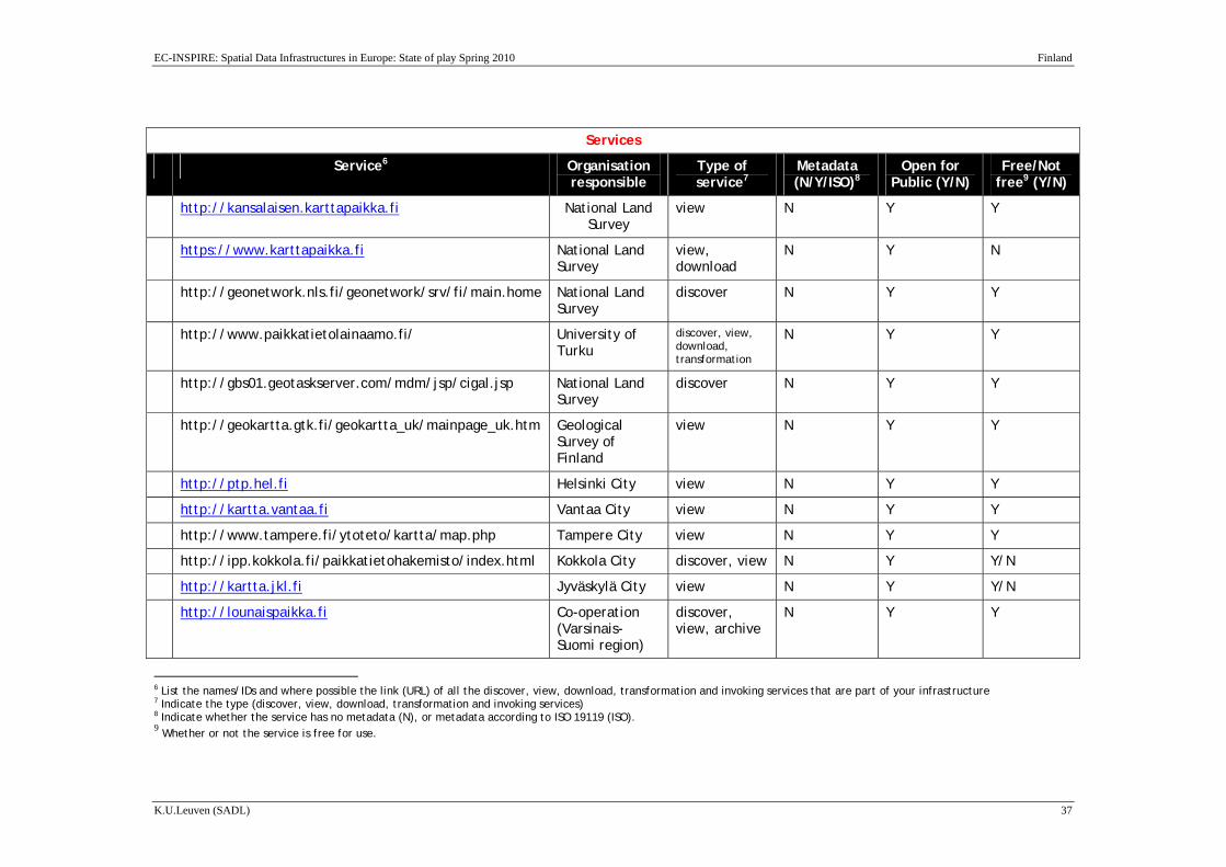
Users can access a spatial index in a search engine either by using wildcards in the metadata element or search by geographical location.
The table on the next page provides information on the services which are considered to be part of the INSPIRE infrastructure.
EC-INSPIRE: Spatial Data Infrastructures in Europe: State of play Spring 2010 Finland
K.U.Leuven (SADL) 37
Services
Service6 Organisation responsible
Type of service7
Metadata (N/Y/ISO)8
Open for Public (Y/N)
Free/Not free9 (Y/N)
http://kansalaisen.karttapaikka.fi National Land Survey
view N Y Y
https://www.karttapaikka.fi National Land Survey
view, download
N Y N
http://geonetwork.nls.fi/geonetwork/srv/fi/main.home National Land Survey
discover N Y Y
http://www.paikkatietolainaamo.fi/ University of Turku
discover, view, download, transformation
N Y Y
http://gbs01.geotaskserver.com/mdm/jsp/cigal.jsp National Land Survey
discover N Y Y
http://geokartta.gtk.fi/geokartta_uk/mainpage_uk.htm Geological Survey of Finland
view N Y Y
http://ptp.hel.fi Helsinki City view N Y Y
http://kartta.vantaa.fi Vantaa City view N Y Y
http://www.tampere.fi/ytoteto/kartta/map.php Tampere City view N Y Y
http://ipp.kokkola.fi/paikkatietohakemisto/index.html Kokkola City discover, view N Y Y/N
http://kartta.jkl.fi Jyväskylä City view N Y Y/N
http://lounaispaikka.fi Co-operation (Varsinais-Suomi region)
discover, view, archive
N Y Y
6 List the names/IDs and where possible the link (URL) of all the discover, view, download, transformation and invoking services that are part of your infrastructure 7 Indicate the type (discover, view, download, transformation and invoking services) 8 Indicate whether the service has no metadata (N), or metadata according to ISO 19119 (ISO). 9 Whether or not the service is free for use.
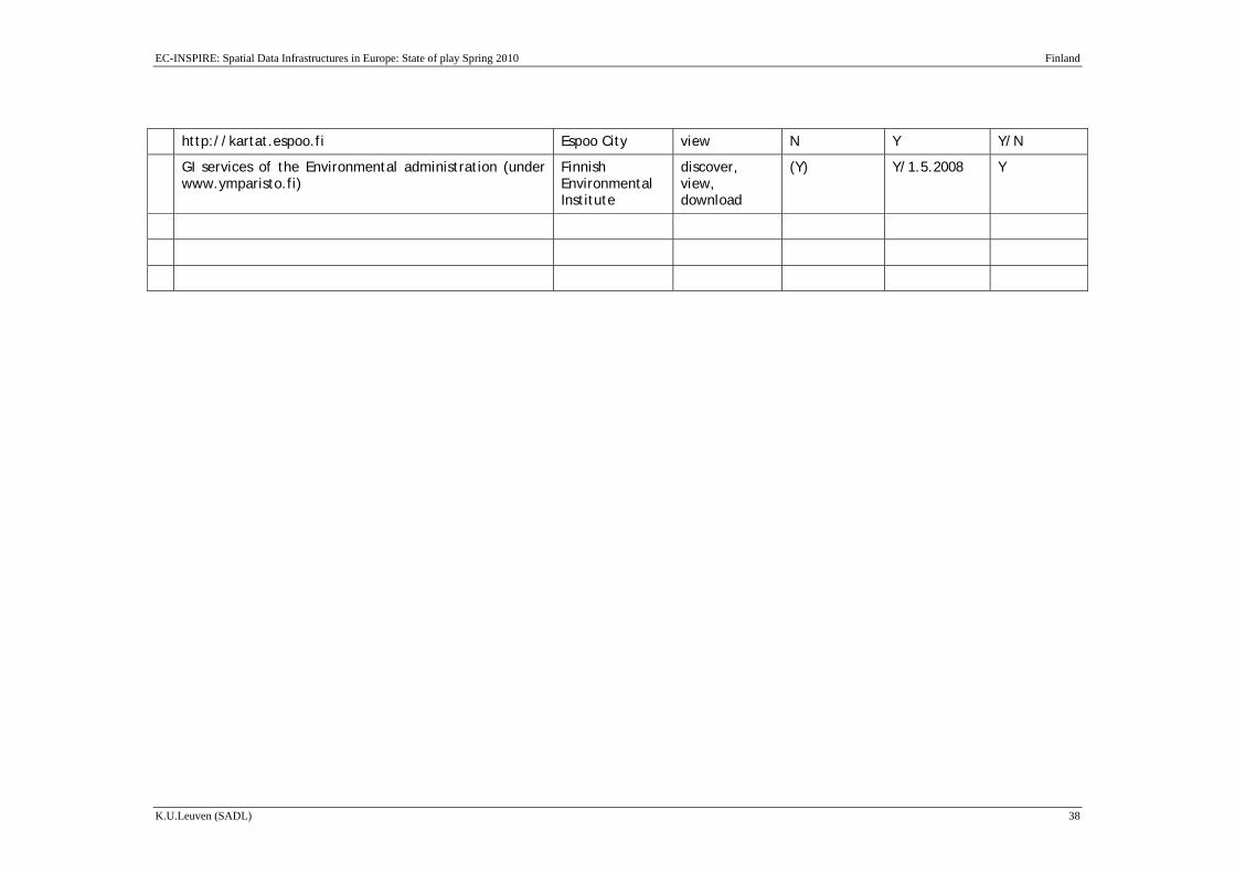
EC-INSPIRE: Spatial Data Infrastructures in Europe: State of play Spring 2010 Finland
K.U.Leuven (SADL) 38
http://kartat.espoo.fi Espoo City view N Y Y/N
GI services of the Environmental administration (under www.ymparisto.fi)
Finnish Environmental Institute
discover, view, download
(Y) Y/1.5.2008
Y

EC-INSPIRE: Spatial Data Infrastructures in Europe: State of play Spring 2010 Finland
K.U.Leuven (SADL) 39
2.6.2 On-line access service data: download services
Paikkatietoikkuna (www.paikkatietoikkuna.fi) is the national geoportal in Finland launched in 7.7.2009. The service is not limited to INSPIRE data themes but includes a variety of geodata. The Website is updated weekly/monthly while the portal is still under development.
The Discovery service (www.paikkatietohakemisto.fi) is a separate service which will be integrated into the geoportal during 2010.
Paikkatietoikkuna offers the user a possibility to browse dozens of map levels, produced by different organizations, on different themes, such as terrain, soil and land use as well as traffic network. In the service, map levels and aerial photos can be viewed simultaneously one on the other, thanks to their adjustable transparency. Antiquities and topographic map or aerial photos and soil map or even nautical chart and topographic map are examples of overlapping functions.
Initially, map data is offered in the service by the Finnish Geodetic Institution, the Geological Survey of Finland, the Finnish Transport Agency, Logica, the National Land Survey of Finland, the Agency for Rural Affairs, the National Board of Antiquities, the Regional Council of Southwest Finland as well as the cities Espoo, Jyväskylä and Turku.
Various kind of map data is sought for the service directly from the data producers’ own systems, in which case the available data is as real time as possible. Download service, in INSPIRE context, will be available at the geoportal late 2010. The numbers of data that can be discovered are around 100 while 30 of them can be viewed.
The NLS started the MapSite service with the aim to create an easy and effective way to distribute maps over the Internet. Users browse through the topographic maps in a seamless way by scrolling through a map, searching by location, place name, address coordinates. The MapSite has two components and detailed usage instructions are provided:
Citizen's MapSite :NLS topographic maps covering all Finnish regions are available at Citizen's MapSite. This service is universally accessible and free of charge.
Professional's MapSite: Professional's MapSite shows NLS topographic maps, cadastral data and sale price information. The service is subject to charge and requires a user contract. This service is only available in Finnish and Swedish.
The data sets cover a geographically predefined “test region” of 40 000km2, allowing overlays, combinations and comparisons of the data sets. The secretariat of the service accepts data from all data providers and an agreement is made to deliver the data sets to registered users (Figure). The registration to the service is open and free of charge, but
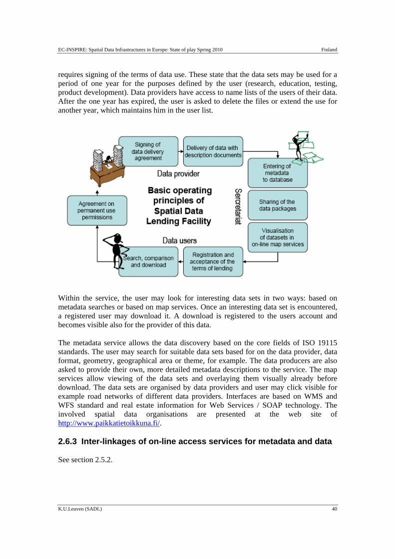
EC-INSPIRE: Spatial Data Infrastructures in Europe: State of play Spring 2010 Finland
K.U.Leuven (SADL) 40
requires signing of the terms of data use. These state that the data sets may be used for a period of one year for the purposes defined by the user (research, education, testing, product development). Data providers have access to name lists of the users of their data. After the one year has expired, the user is asked to delete the files or extend the use for another year, which maintains him in the user list.
Within the service, the user may look for interesting data sets in two ways: based on metadata searches or based on map services. Once an interesting data set is encountered, a registered user may download it. A download is registered to the users account and becomes visible also for the provider of this data.
The metadata service allows the data discovery based on the core fields of ISO 19115 standards. The user may search for suitable data sets based for on the data provider, data format, geometry, geographical area or theme, for example. The data producers are also asked to provide their own, more detailed metadata descriptions to the service. The map services allow viewing of the data sets and overlaying them visually already before download. The data sets are organised by data providers and user may click visible for example road networks of different data providers. Interfaces are based on WMS and WFS standard and real estate information for Web Services / SOAP technology. The involved spatial data organisations are presented at the web site of http://www.paikkatietoikkuna.fi/.
2.6.3 Inter-linkages of on-line access services for metadata and data
See section 2.5.2.

EC-INSPIRE: Spatial Data Infrastructures in Europe: State of play Spring 2010 Finland
K.U.Leuven (SADL) 41
2.6.4 OpenSource software and access services
Recently the Finnish environmental administration has published a new open data access policy. The Geoportal Paikkatietoikkuna is based on open source software. The source code can be downloaded at: (http://demo.paikkatietoikkuna.fi/viewvc).
2.6.5 Availability of viewing services
The finish Geoportal, offers the possibility to browse dozens of map levels, produced by different organizations, on different themes. At the same time it provides the Digitraffic service (http://www.infotripla.fi/digitraffic/english/index.html). Digitraffic is a service offering various information and data about the traffic on the Finnish main roads.
Similarly, NLS provides the MapSite service. MapSite is providing web mapping services that lets the user access to browse-able topographic maps at various scales for all of Finland. A new version was launched in October 2003 (similar to WMS/WFS). The current version offers:
Citizen’s MapSite
Professional MapSite
Ordering Services
Nordic Nomenclature Database
Restrictions to access: the above services are restricted to users with an e-mail address registered with “ .fi” with the exception of Citizen’s MapSite where these restrictions are now removed.
The Citizen’s MapSite service is free of charge but requires registration. Presently there are more than 120.000 registered users, more than a total of 9.5 million hits and on average 85.000 hits per week.
The Professional MapSite service is a paid service providing access to maps at larger scales than the Citizen’s service. There are about 1.000 registered users for this service. Each search of the map data base costs some 0.25€ cents.
Queried data using the on-line ordering service of MapSite are automatically extracted from the database and saved to a personal directory (on the NLS system) or they can be directly downloaded onto the user’s computer. All query results are paid. The on-line service has some 600 customers.
There are already several other web based map services in agriculture, forestry, real estate business etc.
GeoFinland provides a number of viewing services:

EC-INSPIRE: Spatial Data Infrastructures in Europe: State of play Spring 2010 Finland
K.U.Leuven (SADL) 42
Lounaispaikka (GI cooperation in Southwest Finland) at: http://www.lounaispaikka.fi/index.php?lang=en
Guide maps of municipalities available at: http://ptp.hel.fi/opaskartat_en.html
Maps and aerial photos from all of Finland address and route searches, service searches:
Fonecta 020202.fi (in Finnish) available at: http://www.fonecta.fi/
Public transportation and light traffic routes: YTV Journey Plannerat the metropolitan Helsinki area (http://aikataulut.ytv.fi/reittiopas/en/).and Journey.fi nationwide (http://www.matka.fi/haku/fi/).
2.6.6 Availability of catalogue services to regulate access
For those services to identify the user there are some solutions available. One example is the electronic identification card provided by the Population Register Centre. The electronic identification card provided by the Population Register Centre is a secure network key for all on-line services which require the identification of a person, such as all government and many private sector services. The card enables the service provider to reliably identify the user. The card is also an official travel document for Finnish citizens in 19 European countries. However, the card has not been as successful as expected. In many e-business applications the personal security codes offered by banks for internet services have achieved significant role.
2.6.7 Availability of catalogue services that perform payment operations
See Section 2.5.5.
2.6.8 Availability of catalogue services to extract and send data to a user application
It is possible to have various services send data to the user, for example notices sent by e-mail. Also for services providing on line query access to GI data bases, some specific solutions exists e.g. from private sector.
2.6.9 SDI user applications
A number of projects and applications can be pointed to that offer good examples for SDI components. These include but are not limited to the following:
Map and route optimizing services: e.g. http://www.ytv.fi/journeyplanner , etc.
EC-INSPIRE: Spatial Data Infrastructures in Europe: State of play Spring 2010 Finland
K.U.Leuven (SADL) 43
Map viewing services: e.g. https://www.karttapaikka.fi/karttapaikka/default.asp?id=787 (MapSite)
Real estate marketing services: e.g. http://www.etuovi.com
Metadata services: http://www.nls.fi/ptk/aineistot/index and http://www.lounaispaikka.fi
GI data library : http://paikkatietolainaamo.fi/
2.6.10 Availability of geo-processing services
Several private companies and other organizations offer geo-processing and production services. However the markets in Finland are still quite limited.
2.6.11 Conclusions of Component 5
Metadata can be found from Paikkatietohakemisto the Finnish Metadata Catalogue Service. Paikkatietoikkuna (www.paikkatietoikkuna.fi) is the national geoportal in Finland. The service is not limited to INSPIRE data themes but includes a variety of geodata. The Discovery service (www.paikkatietohakemisto.fi) is a separate service which will be integrated into the geoportal during 2010. Moreover the MR confirms that there are 12 view and 5 download services.
Based on these conclusions we score the indicators as follows:
• There are one or more discovery services making it possible to search for data and services through metadata
• There are one or more view services available for to visualise data from the
themes of the INSPIRE annexes
• There are one ore more on-line download services enabling (parts of) copies of datasets
• There are one or more transformation services enabling spatial datasets to be
transformed to achieve interoperability (Not so clear)
• There are middleware services allowing data services to be invoked (No information found)

EC-INSPIRE: Spatial Data Infrastructures in Europe: State of play Spring 2010 Finland
K.U.Leuven (SADL) 44
2.7 Component 6: Thematic environmental data
The Finnish Environment Institute (SYKE) is developing a number of SDI-related components and services together with other GI stakeholders.
2.7.1 Application of the legal framework and funding principles (for reference & core thematic data) to thematic environmental data
No information has been found.
2.7.2 Application of reference data & core thematic data characteristics to thematic environmental data
SYKE has available for staff some 100+ spatial data sets covering the whole of Finland, at a scale of 1:20 000 until 1:1 million or raster pixel sizes from 2 metres until 200 metres. Some of this data is “own” data and some is purchased from other organizations
Own data production by the Finnish Environment Institute includes:
Groundwater areas (cooperation with GTK). The groundwater areas required 3 – 4 calendar years to develop in the regional environmental centres and about 10 man-years of effort to create a data set with 7000 ground water areas.
Protected sites
Protection plans
General plans
NATURA 2000 sites
etc
All GIS data are maintained centrally on the SYKE GIS server. Regional centres make copies of the data base for storing on their own computing networks simply because the network is too slow to work across the Inter/Intranet. In total there are some 250+ ArcView licences (about 6-10 per region, 40 in the SYKE main office). The data bases are available to the whole of the environmental administration via ArcView and also WMS.
SYKE includes several datasets listed in the annexes of INSPIRE such as:
Annex 1:
Protected sites (Natura2000 sites, Nationally designated sites)
Hydrography( River network, Lake database, River basins and catchments)
Annex 2:
EC-INSPIRE: Spatial Data Infrastructures in Europe: State of play Spring 2010 Finland
K.U.Leuven (SADL) 45
Geology ( Groundwater)
Elevation (Bathymetry)
Land Cover ( Corine2000 LU/LC)
Annex 3:
Land Use ( Land Use plans, Land Use Regulations plans)
Environmental monitoring facilities
Area management/restriction/regulation zones and reporting units, Natural risk zones, Sea regions, Bio-geographical regions, Habitats and biotopes, Species distribution
Metadata are available for all datasets (http://www.paikkatietolainaamo.fi/)
A number of theme pages are available in the www.environment.fi web service such as Carbon neutral municipalities (CANEMU), Finnish Water Forum - FWF, etc .
A detailed description is available at: http://www.ymparisto.fi/default.asp?node=4267&lan=en
2.7.3 Application of metadata issues identified for reference data and core thematic data to thematic environmental data
Within SYKE the policy is to provide metadata for its own data sets (data where SYKE is the owner) and own metadata is also made for datasets which are bought and for which metadata are lacking or below standard. Only metadata for SYKE’s own datasets is made available on the Internet. In general the users are giving good feedback to SYKE regarding the metadata provided with the data sets. Presently SYKE metadata is simply created as html files; it is not yet in an actual data base setting.
2.7.4 Application of access services issues identified for reference data and core thematic data to thematic environmental data
WebMapServer (WMS) is available but mainly for Intranet users. To a lesser extent some extranet users can request access for a small fee. The site is still small with only about 30-40 organizations registered as extranet users, for example the regional councils and some municipalities. Plans are already being made to update the site which is too slow. Plans are made to open the WebMapServer for the public and discussion to make SYKE's datasets free to everyone has started.

EC-INSPIRE: Spatial Data Infrastructures in Europe: State of play Spring 2010 Finland
K.U.Leuven (SADL) 46
2.7.5 Application of standards issues identified for reference data and core thematic data to thematic environmental data
Regarding interoperability issues, many of the data users and providers work with ESRI or MapInfo products.
2.7.6 Application of update procedures issues identified for reference data and core thematic data to thematic environmental data
A GIS users’ network has been put in place as early as 1992. There is one general contact person in every unit and regional centre and also one contact person in each place to provide “in-house” GIS expertise. There is a general GIS information exchange via e-mail, intranet discussion group and an annual meeting.
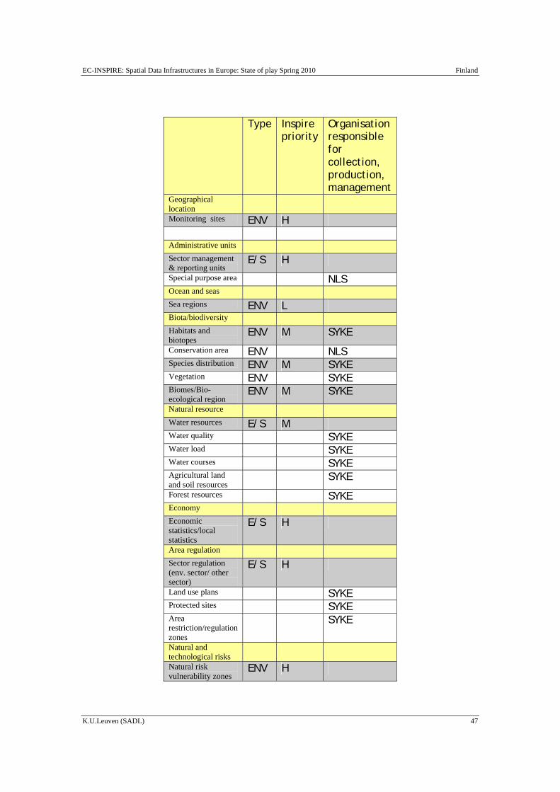
EC-INSPIRE: Spatial Data Infrastructures in Europe: State of play Spring 2010 Finland
K.U.Leuven (SADL) 47
Type Inspire
priority Organisation responsible for collection, production, management
Geographical location
Monitoring sites ENV H Administrative units Sector management & reporting units
E/S H
Special purpose area NLS Ocean and seas Sea regions ENV L Biota/biodiversity Habitats and biotopes
ENV M SYKE
Conservation area ENV NLS Species distribution ENV M SYKE Vegetation ENV SYKE Biomes/Bio-ecological region
ENV M SYKE
Natural resource Water resources E/S M Water quality SYKE Water load SYKE Water courses SYKE Agricultural land and soil resources
SYKE
Forest resources SYKE Economy Economic statistics/local statistics
E/S H
Area regulation Sector regulation (env. sector/ other sector)
E/S H
Land use plans SYKE Protected sites SYKE Area restriction/regulation zones
SYKE
Natural and technological risks
Natural risk vulnerability zones
ENV H
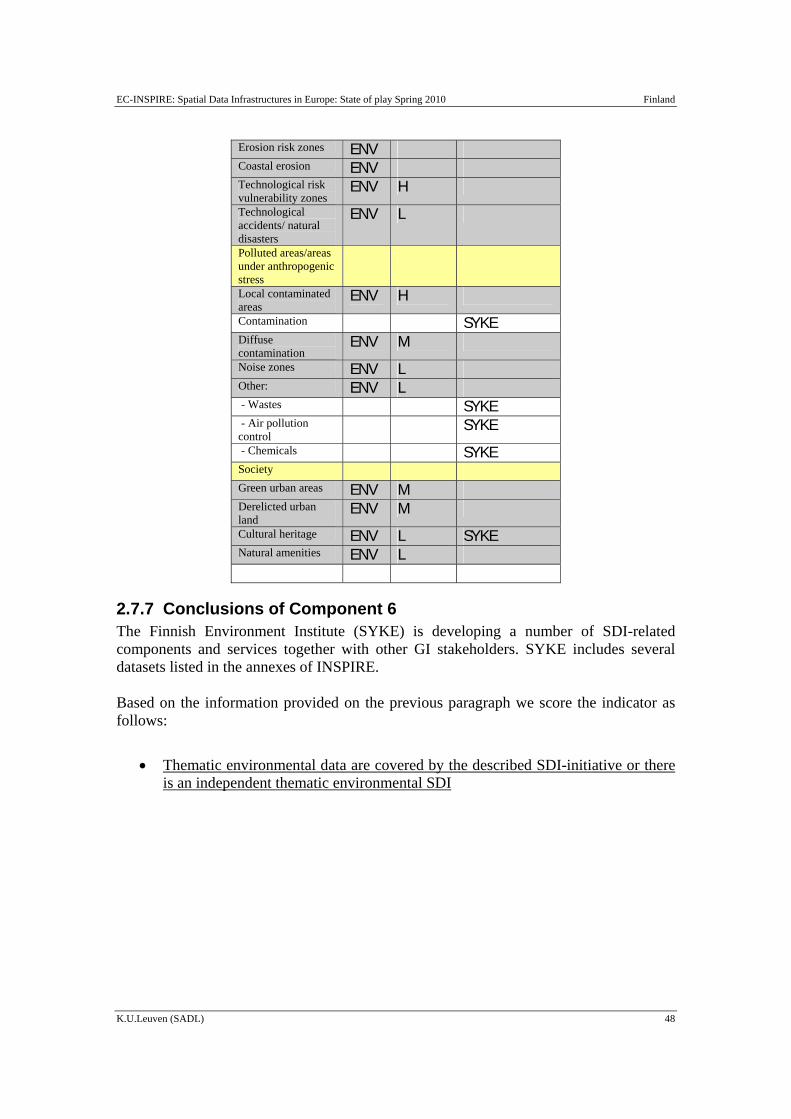
EC-INSPIRE: Spatial Data Infrastructures in Europe: State of play Spring 2010 Finland
K.U.Leuven (SADL) 48
Erosion risk zones ENV Coastal erosion ENV Technological risk vulnerability zones
ENV H
Technological accidents/ natural disasters
ENV L
Polluted areas/areas under anthropogenic stress
Local contaminated areas
ENV H
Contamination SYKE Diffuse contamination
ENV M
Noise zones ENV L Other: ENV L - Wastes SYKE - Air pollution control
SYKE
- Chemicals SYKE Society Green urban areas ENV M Derelicted urban land
ENV M
Cultural heritage ENV L SYKE Natural amenities ENV L
2.7.7 Conclusions of Component 6 The Finnish Environment Institute (SYKE) is developing a number of SDI-related components and services together with other GI stakeholders. SYKE includes several datasets listed in the annexes of INSPIRE. Based on the information provided on the previous paragraph we score the indicator as follows:
• Thematic environmental data are covered by the described SDI-initiative or there is an independent thematic environmental SDI
EC-INSPIRE: Spatial Data Infrastructures in Europe: State of play Spring 2010 Finland
K.U.Leuven (SADL) 49
2.8 Standards
The Finnish Standards Association SFS is an independent, non-profit making organization co-operating with trade federations and industry, research institutes, labour market organizations, consumer organizations, and governmental and local authorities. Members of SFS include professional, commercial and industrial organizations, and the state of Finland represented by the ministries. SFS has been established in 1924.
Moreover, on the webpage of Paikkatietoikkuna a detailed description of INSPIRE, International standards (ISO and OGC) is available (only in Finish). Together with the Public Administration Recommendations (JHS) they provide the core of standards used in the NSDI.
More information can be found at: http://www.paikkatietoikkuna.fi/web/guest/inspire-pikaopas and
http://www.vm.fi/vm/fi/04_julkaisut_ja_asiakirjat/03_muut_asiakirjat/PaikkatietoalanJHStyontulevaisuus.pdf.
2.8.1 Conclusions of Component 7 On the webpage of Paikkatietoikkuna a detailed description of INSPIRE, International standards (ISO and OGC) is available. Together with the Public Administration Recommendations (JHS) they provide the core of standards used in the NSDI. Based on these conclusions we score the indicator as follows:
• The SDI-initiative is devoting significant attention to standardisation issues
2.9 Use and efficiency of SDI
There are several services which are in active use as key components of the Finnish SDI.
The Citizen’s MapSite service is free of charge internet map viewing service. Presently there are more than 120 000 registered users, more than a total of 9.5 million hits and on average 85 000 hits per week.
The electronic Real Estate Data Service is used more than 1 000 000 times a year to produce official printouts. The customers are mainly banks and real estate brokers. This service links data sources from municipalities, NLS and Ministry of Justice.
EC-INSPIRE: Spatial Data Infrastructures in Europe: State of play Spring 2010 Finland
K.U.Leuven (SADL) 50
YTV door-to-door Journey Planner gives advice on the best public transport connection to your destination within the Helsinki region. Also this service is used very actively.

EC-INSPIRE: Spatial Data Infrastructures in Europe: State of play Spring 2010 Finland
K.U.Leuven (SADL) 51
3 Annexes
3.1 List of SDI addresses / contacts for Finland Table: SDI contact list Web address Organisational
mailing address Over-all contact person: tel./fax/e-mail
National Finnish Council for GI, C/O Ministry of Agriculture and Forestry
http://www.mmm.fi
PL 30, 00023 Government
Jarmo Vaittinen, MAF Secretary General, Chairman of FCGI Antti Vertanen, secretary of FCGI [email protected]
National Land Survey of Finland (NLS)
http://www.nls.fi/
P.O. Box 84 FIN-00521 HELSINKI
Jarmo Ratia, General Director [email protected] general e-mail: [email protected] Heli Ursin e-mail: [email protected] Tel: +358 205 41 121 Info +358 205 4111 Fax +358 205 41 5454
NLS - The Development Centre is responsible for developing and supporting cadastral, topographic and geographic information activities. It is also involved in the development of administrative information systems.
http://www.nls.fi/
Timo Tuhkanen, Director e-mail: [email protected]
NLS - The Aerial Image Centre produces
http://www.nls.fi/
Juha Vilhomaa, Director
EC-INSPIRE: Spatial Data Infrastructures in Europe: State of play Spring 2010 Finland
K.U.Leuven (SADL) 52
and sells aerial photographs.
e-mail: [email protected]
NLS - Administrative Services provide the NLS with support and development services in the field of personnel, materials and financial administration.
http://www.nls.fi/ Martti Havila, Director e-mail: [email protected]
NLS - The Computer Centre is responsible for providing the NLS with IT production and support services and for the proper functioning of NLS’s communication networks.
http://www.nls.fi/ Mikko Lipponen, Director e-mail: [email protected]
ProGIS http://www.progis.fi/
National Land Survey of Finland Development Centre P.O.Box 84 FIN-00521 Helsinki
For information: Petri Takala email: [email protected]
Soil and Water Ltd http://soilandwater.poyry.com/
Jaakko Pöyry Group Jaakonkatu 3, 01620 Vantaa Tel. +358 9 89471
Jukka Mäkelä, Vice President, Soil and Water Ltd, Geoinformation Services, P.O.Box 50, Jaakonkatu 3, FIN-01620 VANTAA Tel: +358-9-682661 Fax: +358-9-6826600 jukka.makela at poyry.fi
SYKE http://www.ymparisto.fi/default.asp?node=5297&lan=en
Finnish Environment Institute, Mechelininkatu 34a, P.O. Box 140, FIN-00251
Mr. Yrjö Sucksdorff, (FL, yksikönpäällikkö) E-mail: Yrjo.Sucksdorff at ymparisto.fi

EC-INSPIRE: Spatial Data Infrastructures in Europe: State of play Spring 2010 Finland
K.U.Leuven (SADL) 53
Helsinki, Finland, Phone: + 358 9 403 000, Fax: +358 9 4030 0190
Phone: +358 9 4030 0677 Fax: +358 9 4030 0690
FGI www.fgi.fi Finnish Geodetic Institute, Geodeetirinne 2 P.O. Box 15 FIN- 02431 Masala, Finland/, Risto Kuittinen Director General.
Geodetic reference systems / Prof Markku Poutanen

EC-INSPIRE: Spatial Data Infrastructures in Europe: State of play Spring 2010 Finland
K.U.Leuven (SADL) 54
3.2 List of references for Finland
Table: list of references used to compile the Country Report
Web sites:
PSI policies and their economic impacts
http://205.156.54.206/sp/Borders_report.pdf
Municipal Geographical Database Project
http://akseli.tekes.fi/Resource.phx/rapu/infra/paikkatiedot.htx.liite.liitteet.1.pdf
Customer satisfaction (NLS – Finland)
http://www.cerco.org/OUR_WORKINGGROUPS/WGQ/Ahonen.html
When de Montalvo, Uta http://codazzi4.igac.gov.co/gsdi5/documentos/Uta_Wehn_paper.pdf
EULIS Project http://www.eulis.org/
Legal protection of GI http://www.eurogi.org/geoinfo/publications/legal_report_%20february1996.doc
Data protection: Directive 95/46 http://europa.eu.int/comm/internal_market/en/dataprot/law/impl.htm
Nordic place names database http://nondb.nls.fi/
Free geo-data for Finland http://www.gisdatadepot.com/catalog/FI/datalist.html
The Baltic Sea Region GIS, Maps and Statistical Database
http://www.grida.no/baltic/
BALANS Land Cover project http://www.grida.no/baltic/htmls/related.htm
Masser, Ian http://www.gsdi.org/docs/canberra/masser.html
Geologic survey of Finland http://www.gsf.fi/
MapSite (NLS) http://www.kartta.nls.fi/index_e.html
Swedish NMA – cooperation projects
http://www.lantmateriet.se/cms/level2index.asp?produktgrupp=3004
National Land Survey (NLS) http://www.maanmittauslaitos.fi/default.asp?site=3
NGII Strategy document Finland (1995)
http://www.nls.fi/ptk/infrastructure/index.html
Barents GIT http://www.nls.fi/org/inter/barents_git/
ProGIS (NLS information) http://www.nls.fi/progis/index_e.html
ProGIS http://www.progis.fi/
EC-INSPIRE: Spatial Data Infrastructures in Europe: State of play Spring 2010 Finland
K.U.Leuven (SADL) 55
Statistics Finland – Regional & GIS
http://www.stat.fi/tk/he/paikkatiedot/paikkatieto_en.html
Public-Private Cooperation in Finland
http://www.vugtk.cz/~nemoforum/adr03/ratia1.html
GISEDI Europe Project http://www.uudenmaanliitto.fi/gisedi/english.htm
GISEDI Europe Project – Metadata
http://www.uudenmaanliitto.fi/gisedi/metaframe.htm
Environmental Administration http://www.environment.fi
LUMONET - Clearing-House Mechanism
http://www.vyh.fi/eng/environ/bdclearh/welcome.htm
Environmental data system http://www.vyh.fi/eng/orginfo/database/eds.html
Finish Information Society R & D
http://194.100.30.11/tietoyhteiskunta/
NSDI Clearinghouse: Paikkatietohakemisto
http://www.nls.fi/ptk/aineistot/
http://www.sogi.ch/Profiles.pdf
http://www.vm.fi/vm/fi/04_julkaisut_ja_asiakirjat/03_muut_asiakirjat/PaikkatietoalanJHStyontulevaisuus.pdf
http://geoinfo.fgi.fi/TIPY/TIPY1/strategia_toimenpiteet.php#P2
https://www.karttapaikka.fi/karttapaikka/default.asp?id=787
http://www.maanmittauslaitos.fi/paikkatiedot/default.asp?id=866&refresh=1
http://www.paikkatietoikkuna.fi/web/guest
Publications:
Craglia, M. (2000). Geographic Information Policies in Europe: Naional and Regional Perspectives – Report of the EUROGI-EC Data Policy Workshop, Amersfoort, 15 November 1999.
Clark, Mike (2002). Briefing notes to the INSPIRE DPLI Working Group, Appendix A – EU Member States (brief1.doc).
GINIE: Geographic Information Network in Europe. Spatial data infrastructures: Country Reports FINAL D 5.3.2(b). September 2002.
Masser, Ian (1999) “All shapes and sizes: the first generation of national spatial data infrastructures”, International Journal of Geographic Information
EC-INSPIRE: Spatial Data Infrastructures in Europe: State of play Spring 2010 Finland
K.U.Leuven (SADL) 56
Science, vol. 13(1), pp. 67-84
Onrud, H., Department of Spatial Information Science and Engineering, University of Maine, Orono, Maine. GSDI - Survey of National and Regional Spatial Data Infrastructure Activities Around the Globe, Part I – National Spatial Data Infrastructure Initiatives. http://www.spatial.maine.edu/~onsrud/GSDI.htm
Rainio, Antti (1996). The Consultative Committee for Data Administration in Public Administration, Publication 2/1996. “National Geographic Information Infrastructure of Finland - starting point and future objectives for the information society”
Statistics Finland, Statistics Sweden, and Statistics Norway (2000). UN/ECE Work Session on Methodological Issues Involving the Integration of Statistics and Geography (10-12 April 2000). Working Paper No. 24, “GRID data and area delimitation by definition – towards a better European territorial statistical system”
Statistics Finland (2000). UN/ECE Work Session on Methodological Issues Involving the Integration of Statistics and Geography (10-12 April 2000). Working Paper No. 22, “Internet application of election results on maps”
Tiainen, Esa, National Land Survey of Finland Development Centre (2000). “National Plan Data System in Finland”
When de Montalvo, Uta (2001). “Strategies for SDI implementation: A survey of national experiences. Paper presented at the 5th Global Spatial Data Infrastructure Conference, 21-25 May 2001
Other sources:
Crompvoets, Joep (2002). E-mail of 08-11-2002. Subject: Notes regarding the SDI situation in Luxembourg and Finland.
Written comments as received from the Ministry of Agriculture and Forestry and the National Land Survey of Finland.
GINIE - GI in the Wider Europe Complete Book, October 2003 http://wwwlmu.jrc.it/ginie/doc/ginie_book.pdf
Riitta Teiniranta; Yrjö, Sucksdorff; Mikko, Hynninen and Riikka, Repo (2007). Renewing the National Environmental SDI in Finland Taking into Account Modern Possibilities and the Inspire Directive. 6th of July 2007, 13th EC GI & GIS Workshop
Jaana Mäkelä, Riitta Vaniala and Paula Ahonen-Rainio. The role of user organizations in the implementation of National Spatial Data InfrastructureGSDI-11Rotterdam,The Netherlands 15-19 June 2009.

EC-INSPIRE: Spatial Data Infrastructures in Europe: State of play Spring 2010 Finland
K.U.Leuven (SADL) 57
Pekka Tätilä, Heli Laaksonen and Veikko, Jantunen (2009). National Report – Finland. Eighteenth United Nations Regional Cartographic Conference for Asia and the Pacific Bangkok, 26-29 October 2009. Item 7(a) of the provisional agenda Country Reports
Aune, Rummukainen (2009). Contents of Finnish Cadastral System. GIG Workign Week, EILAT 2009 Israel.
Juha Tuomaala (2008).Practical experience to renew all GISbased production applications successfully in National Land Survey of Finland. GSDI 10/28.02.2008.
Jarmo Ratia. The National Geographic Information Strategy of Finland. Available at: www.gsdidocs.org/gsdiconf/GSDI-9


![MIT OpenCourseWare 6.189 Multicore …...Running Processes Under GDB ppu-gdb ./hello-world (gdb) run [args] … (gdb) quit export SPU_INFO=1 for extra information about threads Phil](https://img.pdfslide.net/doc/110x75/5f19ba63a6b0b957e67c7a59/mit-opencourseware-6189-multicore-running-processes-under-gdb-ppu-gdb-hello-world.jpg)

![GDB telux ver090906 - cs.tau.ac.il · (gdb) watch expr –stops whenever the value of the expression changes (gdb ) i b (gdb) clear [arg ] (gdb) delete [bnum ] Without arguments deletes](https://img.pdfslide.net/doc/110x75/5ae0abbc7f8b9ab4688daeeb/gdb-telux-ver090906-cstauacil-gdb-watch-expr-stops-whenever-the-value-of.jpg)