Embed Size (px)
Citation preview
SpatialHadoop: Towards Flexible and ScalableSpatial Processing using MapReduce
Ahmed EldawyExpected Graduation: December 2015
Supervised by: Mohamed F. MokbelComputer Science and Engineering DepartmentUniversity of Minnesota Minneapolis, MN, USA
{eldawy,mokbel}@cs.umn.edu
ABSTRACTWith the huge volumes of spatial data coming from differentsources, there is an increasing demand to exploit the efficiency ofHadoop MapReduce framework in spatial data processing. How-ever, Hadoop falls short in supporting spatial data efficiently as thecore is unaware of spatial data properties. This paper describesSpatialHadoop; a full-fledged MapReduce framework with nativesupport for spatial data. SpatialHadoop is a comprehensiveexten-sion to Hadoop that injects spatial data awareness in the main layersof Hadoop. It ships with a simple high level language with spatialdatatypes and operations. The core contains traditional spatial in-dexes, Grid, R-tree and R+-tree, which are adapted to the MapRe-duce environment. SpatialHadoop is already equipped with adozenof operations, including standard operations, computational geom-etry and data mining operations. SpatialHadoop is already usedas a main component in three live systems MNTG, TAREEG andSHAHED. For efficient processing of spatio-temporal data, Spatio-temporal Hadoop is proposed as an extension to SpatialHadoop.
Categories and Subject DescriptorsH.2.8 [Database Management]: Database ApplicationsSpatialDatabases and GIS
KeywordsHadoop; MapReduce; Spatial; Indexing
1. INTRODUCTIONThe recent explosion in the amounts of spatial data urged re-
searchers and practitioners worldwide to take advantage oftheMapReduce environment in supporting large-scale spatial data.Most notably, in industry, ESRI has released a suite of GIS toolson Hadoop [1] that work with their flagship ArcGIS product.
This work is supported in part by the National Science Foundation, USA,under Grants IIS-0952977 and IIS-1218168.
Permission to make digital or hard copies of all or part of this work for personal orclassroom use is granted without fee provided that copies are not made or distributedfor profit or commercial advantage and that copies bear this notice and the full cita-tion on the first page. Copyrights for components of this workowned by others thanACM must be honored. Abstracting with credit is permitted. To copy otherwise, or re-publish, to post on servers or to redistribute to lists, requires prior specific permissionand/or a fee. Request permissions from [email protected]’14 PhD Symposium,June 22, 2014, Snowbird, UT, USACopyright 2014 ACM 978-1-4503-2924-8/14/06 ...$15.00.http://dx.doi.org/10.1145/2602622.2602625.
Meanwhile, in academia, three system prototypes were proposed:(1) Parallel-Secondo [12] as a parallel spatial DBMS that usesHadoop as a distributed task scheduler, (2)MD-HBase [14] ex-tends HBase [2], a non-relational database runs on top of Hadoop,to support multidimensional indexes, and (3) Hadoop-GIS [6] ex-tends Hive [16], a data warehouse infrastructure built on top ofHadoop with a uniform grid index for range queries and self-join.
A main drawback in the systems discussed above is the lack ofintegration with the core of Hadoop. For example, HadoopGISisbuilt on Hive, a data warehousing system for Hadoop, renderingit unuseful for traditional MapReduce programs running directlyin Hadoop. On the other hand, SpatialHadoop isbuilt-in Hadoopwhich pushes spatial constructs inside the core of Hadoop makingit more efficient with query processing. More importantly, Spatial-Hadoop introduces standard spatial indexes and MapReduce com-ponents that allow researchers and developers to implementnewspatial operations efficiently in the system. This is in contrast toHadoop-GIS and other systems that cannot support such kind offlexibility, and hence they are limited to the functions theyshipwith. Finally, indexing options in previous systems are limited,e.g., uniform grid index in HadoopGIS, while SpatialHadooppro-vides more options including Grid File, R-tree and R+-tree,whichmakes it more useful with skewed data.
SpatialHadoop is available as open source [3] and has been al-ready downloaded more than 75,000 times. SpatialHadoop is ac-cessible through a high level language, named Pigeon [11], whichextends Pig Latin with OGC-standard [4] data types and operations.In the core of SpatialHadoop, Grid File, R-tree and R+-tree indexesare adapted to the Hadoop file system (HDFS) by building them asa global index which partition data across nodes and multiple localindexes to organize records inside each node. The new indexes aremade accessible to MapReduce programs by introducing two newcomponents, SpatialFileSplitter and SpatialRecordReader whichare used to access the global and local indexes, respectively. Thenew design of spatial indexes allows a myriad spatial operationsto be implemented efficiently in SpatialHadoop. We show how toimplement three basic operations, range query, kNN and spatialjoin [10]. In addition, we build CG_Hadoop [9], a suite of compu-tational geometry operations, in SpatialHadoop which makes useof spatial indexes to provide orders of magnitude speedup. Spa-tialHadoop is also used in three live systems, MNTG [13] a webservice for generating traffic data, TAREEG [7], a web-basedex-traction tool for OpenStreetMap data, and SHAHED, a system foranalyzing satellite data from NASA. In order to support spatio-temporal data processing, we propose Spatio-temporal Hadoop asan extension that takes the time dimension into account.
Storage
MapReduce
MasterSlaves
Map/Reduce
Tasks
Configured
MapReduce Job
Index
Information
Storage/Processing
Nodes
Language Pigeon
Spatial
Operations
System
Admin
Casual User
Developer
Config
Files
Grid File, R-tree
R+-tree Indexes
SpatialRecordReader
SpatialFileSplitter
File Data
System
Parameters
Operations Basic Operations CG_Hadoop Spatial Data Mining
SHAHEDTAREEGMNTG
Applications
Spatio
-tem
pora
l Hado
op
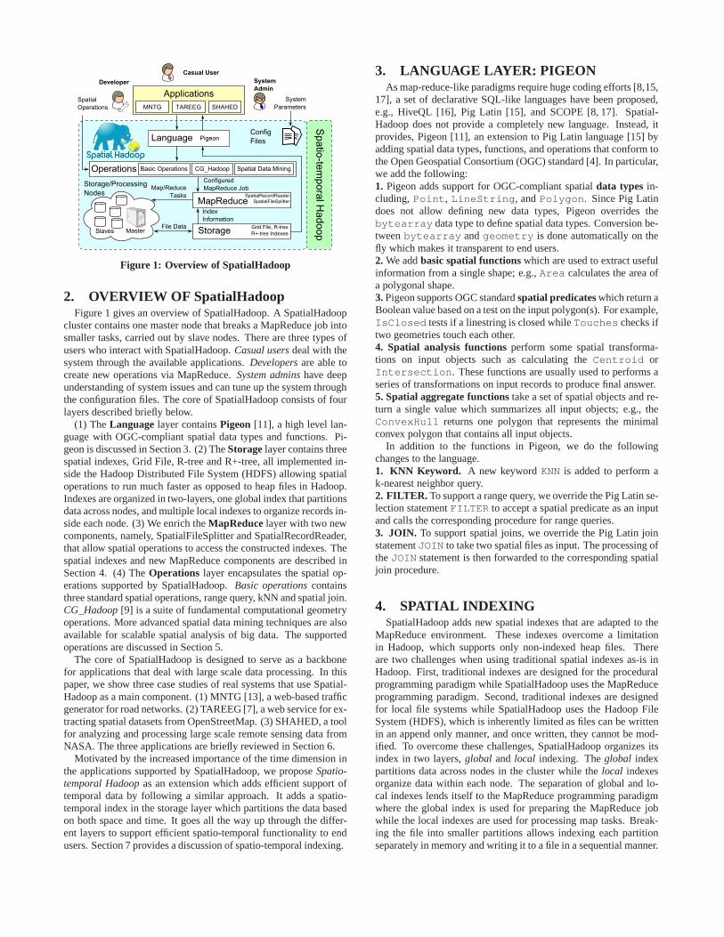
Figure 1: Overview of SpatialHadoop
2. OVERVIEW OF SpatialHadoopFigure 1 gives an overview of SpatialHadoop. A SpatialHadoop
cluster contains one master node that breaks a MapReduce jobintosmaller tasks, carried out by slave nodes. There are three types ofusers who interact with SpatialHadoop.Casual usersdeal with thesystem through the available applications.Developersare able tocreate new operations via MapReduce.System adminshave deepunderstanding of system issues and can tune up the system throughthe configuration files. The core of SpatialHadoop consists of fourlayers described briefly below.
(1) TheLanguage layer containsPigeon [11], a high level lan-guage with OGC-compliant spatial data types and functions.Pi-geon is discussed in Section 3. (2) TheStorage layer contains threespatial indexes, Grid File, R-tree and R+-tree, all implemented in-side the Hadoop Distributed File System (HDFS) allowing spatialoperations to run much faster as opposed to heap files in Hadoop.Indexes are organized in two-layers, one global index that partitionsdata across nodes, and multiple local indexes to organize records in-side each node. (3) We enrich theMapReduce layer with two newcomponents, namely, SpatialFileSplitter and SpatialRecordReader,that allow spatial operations to access the constructed indexes. Thespatial indexes and new MapReduce components are describedinSection 4. (4) TheOperations layer encapsulates the spatial op-erations supported by SpatialHadoop.Basic operationscontainsthree standard spatial operations, range query, kNN and spatial join.CG_Hadoop[9] is a suite of fundamental computational geometryoperations. More advanced spatial data mining techniques are alsoavailable for scalable spatial analysis of big data. The supportedoperations are discussed in Section 5.
The core of SpatialHadoop is designed to serve as a backbonefor applications that deal with large scale data processing. In thispaper, we show three case studies of real systems that use Spatial-Hadoop as a main component. (1) MNTG [13], a web-based trafficgenerator for road networks. (2) TAREEG [7], a web service for ex-tracting spatial datasets from OpenStreetMap. (3) SHAHED,a toolfor analyzing and processing large scale remote sensing data fromNASA. The three applications are briefly reviewed in Section6.
Motivated by the increased importance of the time dimensioninthe applications supported by SpatialHadoop, we proposeSpatio-temporal Hadoopas an extension which adds efficient support oftemporal data by following a similar approach. It adds a spatio-temporal index in the storage layer which partitions the data basedon both space and time. It goes all the way up through the differ-ent layers to support efficient spatio-temporal functionality to endusers. Section 7 provides a discussion of spatio-temporal indexing.
3. LANGUAGE LAYER: PIGEONAs map-reduce-like paradigms require huge coding efforts [8,15,
17], a set of declarative SQL-like languages have been proposed,e.g., HiveQL [16], Pig Latin [15], and SCOPE [8, 17]. Spatial-Hadoop does not provide a completely new language. Instead,itprovides, Pigeon [11], an extension to Pig Latin language [15] byadding spatial data types, functions, and operations that conform tothe Open Geospatial Consortium (OGC) standard [4]. In particular,we add the following:1. Pigeon adds support for OGC-compliant spatialdata types in-cluding,Point, LineString, andPolygon. Since Pig Latindoes not allow defining new data types, Pigeon overrides thebytearray data type to define spatial data types. Conversion be-tweenbytearray andgeometry is done automatically on thefly which makes it transparent to end users.2. We addbasic spatial functions which are used to extract usefulinformation from a single shape; e.g.,Area calculates the area ofa polygonal shape.3. Pigeon supports OGC standardspatial predicates which return aBoolean value based on a test on the input polygon(s). For example,IsClosed tests if a linestring is closed whileTouches checks iftwo geometries touch each other.4. Spatial analysis functions perform some spatial transforma-tions on input objects such as calculating theCentroid orIntersection. These functions are usually used to performs aseries of transformations on input records to produce final answer.5. Spatial aggregate functions take a set of spatial objects and re-turn a single value which summarizes all input objects; e.g., theConvexHull returns one polygon that represents the minimalconvex polygon that contains all input objects.
In addition to the functions in Pigeon, we do the followingchanges to the language.1. KNN Keyword. A new keywordKNN is added to perform ak-nearest neighbor query.2. FILTER. To support a range query, we override the Pig Latin se-lection statementFILTER to accept a spatial predicate as an inputand calls the corresponding procedure for range queries.3. JOIN. To support spatial joins, we override the Pig Latin joinstatementJOIN to take two spatial files as input. The processing oftheJOIN statement is then forwarded to the corresponding spatialjoin procedure.
4. SPATIAL INDEXINGSpatialHadoop adds new spatial indexes that are adapted to the
MapReduce environment. These indexes overcome a limitationin Hadoop, which supports only non-indexed heap files. Thereare two challenges when using traditional spatial indexes as-is inHadoop. First, traditional indexes are designed for the proceduralprogramming paradigm while SpatialHadoop uses the MapReduceprogramming paradigm. Second, traditional indexes are designedfor local file systems while SpatialHadoop uses the Hadoop FileSystem (HDFS), which is inherently limited as files can be writtenin an append only manner, and once written, they cannot be mod-ified. To overcome these challenges, SpatialHadoop organizes itsindex in two layers,global and local indexing. Theglobal indexpartitions data across nodes in the cluster while thelocal indexesorganize data within each node. The separation of global andlo-cal indexes lends itself to the MapReduce programming paradigmwhere the global index is used for preparing the MapReduce jobwhile the local indexes are used for processing map tasks. Break-ing the file into smaller partitions allows indexing each partitionseparately in memory and writing it to a file in a sequential manner.
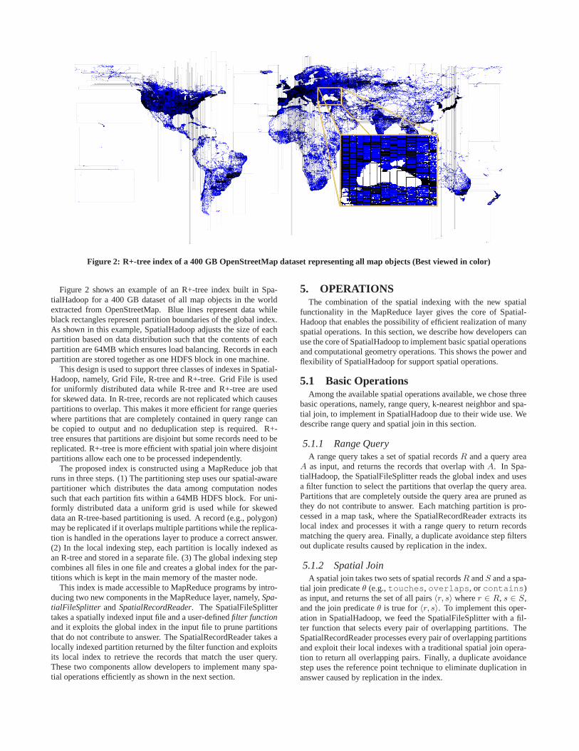
Figure 2: R+-tree index of a 400 GB OpenStreetMap dataset representing all map objects (Best viewed in color)
Figure 2 shows an example of an R+-tree index built in Spa-tialHadoop for a 400 GB dataset of all map objects in the worldextracted from OpenStreetMap. Blue lines represent data whileblack rectangles represent partition boundaries of the global index.As shown in this example, SpatialHadoop adjusts the size of eachpartition based on data distribution such that the contentsof eachpartition are 64MB which ensures load balancing. Records ineachpartition are stored together as one HDFS block in one machine.
This design is used to support three classes of indexes in Spatial-Hadoop, namely, Grid File, R-tree and R+-tree. Grid File is usedfor uniformly distributed data while R-tree and R+-tree areusedfor skewed data. In R-tree, records are not replicated whichcausespartitions to overlap. This makes it more efficient for rangequerieswhere partitions that are completely contained in query range canbe copied to output and no deduplication step is required. R+-tree ensures that partitions are disjoint but some records need to bereplicated. R+-tree is more efficient with spatial join where disjointpartitions allow each one to be processed independently.
The proposed index is constructed using a MapReduce job thatruns in three steps. (1) The partitioning step uses our spatial-awarepartitioner which distributes the data among computation nodessuch that each partition fits within a 64MB HDFS block. For uni-formly distributed data a uniform grid is used while for skeweddata an R-tree-based partitioning is used. A record (e.g., polygon)may be replicated if it overlaps multiple partitions while the replica-tion is handled in the operations layer to produce a correct answer.(2) In the local indexing step, each partition is locally indexed asan R-tree and stored in a separate file. (3) The global indexing stepcombines all files in one file and creates a global index for thepar-titions which is kept in the main memory of the master node.
This index is made accessible to MapReduce programs by intro-ducing two new components in the MapReduce layer, namely,Spa-tialFileSplitter and SpatialRecordReader. The SpatialFileSplittertakes a spatially indexed input file and a user-definedfilter functionand it exploits the global index in the input file to prune partitionsthat do not contribute to answer. The SpatialRecordReader takes alocally indexed partition returned by the filter function and exploitsits local index to retrieve the records that match the user query.These two components allow developers to implement many spa-tial operations efficiently as shown in the next section.
5. OPERATIONSThe combination of the spatial indexing with the new spatial
functionality in the MapReduce layer gives the core of Spatial-Hadoop that enables the possibility of efficient realization of manyspatial operations. In this section, we describe how developers canuse the core of SpatialHadoop to implement basic spatial operationsand computational geometry operations. This shows the power andflexibility of SpatialHadoop for support spatial operations.
5.1 Basic OperationsAmong the available spatial operations available, we chosethree
basic operations, namely, range query, k-nearest neighborand spa-tial join, to implement in SpatialHadoop due to their wide use. Wedescribe range query and spatial join in this section.
5.1.1 Range QueryA range query takes a set of spatial recordsR and a query area
A as input, and returns the records that overlap withA. In Spa-tialHadoop, the SpatialFileSplitter reads the global index and usesa filter function to select the partitions that overlap the query area.Partitions that are completely outside the query area are pruned asthey do not contribute to answer. Each matching partition ispro-cessed in a map task, where the SpatialRecordReader extracts itslocal index and processes it with a range query to return recordsmatching the query area. Finally, a duplicate avoidance step filtersout duplicate results caused by replication in the index.
5.1.2 Spatial JoinA spatial join takes two sets of spatial recordsR andS and a spa-
tial join predicateθ (e.g.,touches, overlaps, or contains)as input, and returns the set of all pairs〈r, s〉 wherer ∈ R, s ∈ S,and the join predicateθ is true for〈r, s〉. To implement this oper-ation in SpatialHadoop, we feed the SpatialFileSplitter with a fil-ter function that selects every pair of overlapping partitions. TheSpatialRecordReader processes every pair of overlapping partitionsand exploit their local indexes with a traditional spatial join opera-tion to return all overlapping pairs. Finally, a duplicate avoidancestep uses the reference point technique to eliminate duplication inanswer caused by replication in the index.
(a) Input Polygons (b) Union (c) Input Points (d) SkylineConvex Hull
Closest Pair
Farthest Pair
(e) Other Operations
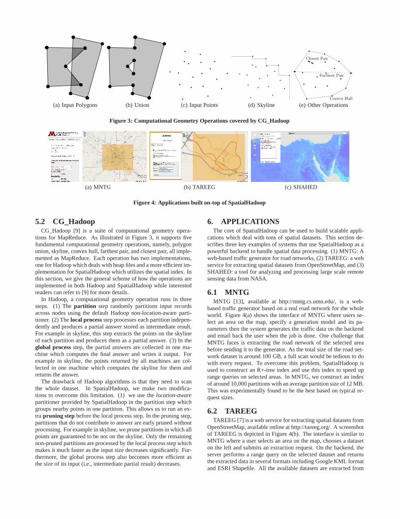
Figure 3: Computational Geometry Operations covered by CG_Hadoop
(a) MNTG (b) TAREEG (c) SHAHED
Figure 4: Applications built on-top of SpatialHadoop
5.2 CG_HadoopCG_Hadoop [9] is a suite of computational geometry opera-
tions for MapReduce. As illustrated in Figure 3, it supportsfivefundamental computational geometry operations, namely, polygonunion, skyline, convex hull, farthest pair, and closest pair, all imple-mented as MapReduce. Each operation has two implementations,one for Hadoop which deals with heap files and a more efficient im-plementation for SpatialHadoop which utilizes the spatialindex. Inthis section, we give the general scheme of how the operations areimplemented in both Hadoop and SpatialHadoop while interestedreaders can refer to [9] for more details.
In Hadoop, a computational geometry operation runs in threesteps. (1) Thepartition step randomly partitions input recordsacross nodes using the default Hadoop non-location-aware parti-tioner. (2) Thelocal process step processes each partition indepen-dently and produces a partial answer stored as intermediateresult.For example in skyline, this step extracts the points on the skylineof each partition and produces them as a partial answer. (3) In theglobal process step, the partial answers are collected in one ma-chine which computes the final answer and writes it output. Forexample in skyline, the points returned by all machines are col-lected in one machine which computes the skyline for them andreturns the answer.
The drawback of Hadoop algorithms is that they need to scanthe whole dataset. In SpatialHadoop, we make two modifica-tions to overcome this limitation. (1) we use thelocation-awarepartitioner provided by SpatialHadoop in the partition step whichgroups nearby points in one partition. This allows us to run an ex-tra pruning step before the local process step. In the pruning step,partitions that do not contribute to answer are early prunedwithoutprocessing. For example in skyline, we prune partitions in which allpoints are guaranteed to be not on the skyline. Only the remainingnon-pruned partitions are processed by the local process step whichmakes it much faster as the input size decreases significantly. Fur-thermore, the global process step also becomes more efficient asthe size of its input (i.e., intermediate partial result) decreases.
6. APPLICATIONSThe core of SpatialHadoop can be used to build scalable appli-
cations which deal with tons of spatial datasets. This section de-scribes three key examples of systems that use SpatialHadoop as apowerful backend to handle spatial data processing. (1) MNTG: Aweb-based traffic generator for road networks, (2) TAREEG: awebservice for extracting spatial datasets from OpenStreetMap, and (3)SHAHED: a tool for analyzing and processing large scale remotesensing data from NASA.
6.1 MNTGMNTG [13], available at http://mntg.cs.umn.edu/, is a web-
based traffic generator based on a real road network for the wholeworld. Figure 4(a) shows the interface of MNTG where users se-lect an area on the map, specify a generation model and its pa-rameters then the system generates the traffic data on the backendand email back the user when the job is done. One challenge thatMNTG faces is extracting the road network of the selected areabefore sending it to the generator. As the total size of the road net-work dataset is around 100 GB, a full scan would be tedious to dowith every request. To overcome this problem, SpatialHadoop isused to construct an R+-tree index and use this index to speeduprange queries on selected areas. In MNTG, we construct an indexof around 10,000 partitions with an average partition size of 12 MB.This was experimentally found to be the best based on typicalre-quest sizes.
6.2 TAREEGTAREEG [7] is a web service for extracting spatial datasets from
OpenStreetMap, available online at http://tareeg.org/. Ascreenshotof TAREEG is depicted in Figure 4(b). The interface is similar toMNTG where a user selects an area on the map, chooses a dataseton the left and submits an extraction request. On the backend, theserver performs a range query on the selected dataset and returnsthe extracted data in several formats including Google KML formatand ESRI Shapefile. All the available datasets are extractedfrom
Jan Feb 1 2 320132012
Figure 5: Spatio-temporal index
OpenStreetMap using a MapReduce extractor that runs in Spatial-Hadoop. A Pigeon script is used to create points and connect themto form lines which form the shapes of the data (e.g., lakes androads). After generating the datasets, SpatialHadoop is used tobuild R+-tree indexes, one per dataset, in order to speed up rangequeries. Total size of all datasets is around 400 GB.
6.3 SHAHEDSHAHED is a tool for analyzing and exploring remote sensing
data publicly available by NASA in a 500 TB archive [5]. SHA-HED provides a web interface where users navigate through themap and the system displays satellite data for the selected area. Forexample, Figure 4(c) displays the heat map of temperature onthenight of the selected date. In addition, users can select an area andask the system to display the change of temperature over a selectedtime period as a video2. A user can also select an area and per-form an analysis task on that area. For example, find anomalouspatterns of vegetation in the selected area. This system uses Spa-tialHadoop to pre-compute the heat maps for available datasets andmakes them available to the web browser for map navigation. Thedata mining module in the operations layer is also used to performdata analysis tasks issued by user.
7. SPATIO-TEMPORAL HADOOPAs we are working on the applications and datasets discussed
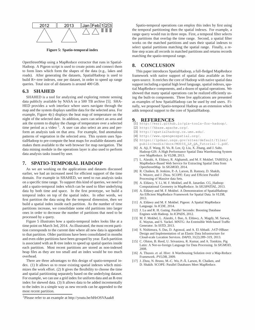
earlier, we had an increased need for efficient support of thetimedomain. For example in SHAHED, we need to run analysis taskson a specific time range. To support this kind of queries, we need toadd a spatio-temporal index which can be used to filter underlyingdata by both time and space. In the first prototype, we build atemporal index on top of the spatial index. In other words, wefirst partition the data using the the temporal dimension, then webuild a spatial index inside each partition. As the number oftimepartitions increase, we consolidate some old partitions into largerones in order to decrease the number of partitions that need to beprocessed by a query.
Figure 5 illustrates how a spatio-temporal index looks likeat atime point on March 3rd, 2014. As illustrated, the most recent parti-tion corresponds to the current date where all new data is appendedto that partition. Older partitions have been consolidatedin monthsand even older partitions have been grouped by year. Each partitionis associated with an R-tree index to speed up spatial queries insideeach partition. Most recent partitions are stored as non-indexedheap files as they are too small and an index would be too muchoverhead.
There are three advantages to this design of spatio-temporal in-dex. (1) It allows us to reuse existing spatial indexes whichmini-mizes the work effort. (2) It gives the flexibility to choose the timeand spatial partitioning separately based on the underlying dataset.For example, we can use a grid index for uniform data and an R-treeindex for skewed data. (3) It allows data to be added incrementallyto the index in a simple way as new records can be appended to themost recent partition.2Please refer to an example at http://youtu.be/hHrOSVAaak8
Spatio-temporal operations can employ this index by first usingthe temporal partitioning then the spatial indexes. For example, arange query would run in three steps. First, a temporal filterselectsthe partitions that overlap the time range. Second, a spatial filterworks on the matched partitions and uses their spatial indexes toselect spatial partitions matching the spatial range. Finally, a re-fine step scans all records in matched partitions and returnsrecordsmatching the spatio-temporal range.
8. CONCLUSIONThis paper introduces SpatialHadoop, a full-fledged MapReduce
framework with native support of spatial data available as freeopen-source. It enriches the core of Hadoop with native spatial datasupport including a spatial high level language, spatial indexes, spa-tial MapReduce components, and a dozen of spatial operations. Weshowed that many spatial operations can be realized efficiently us-ing the built-in components. Three live applications are presentedas examples of how SpatialHadoop can be used by end users. Fi-nally, we proposed Spatio-temporal Hadoop as an extension whichadds temporal support to the core of SpatialHadoop.
9. REFERENCES[1] http://esri.github.io/gis-tools-for-hadoop/.[2] http://hbase.apache.org/.[3] http://spatialhadoop.cs.umn.edu/.[4] http://www.opengeospatial.org/.[5] https://lpdaac.usgs.gov/sites/default/files/
public/modis/docs/MODIS_LP_QA_Tutorial-1.pdf.[6] A. Aji, F. Wang, H. Vo, R. Lee, Q. Liu, X. Zhang, and J. Saltz.
Hadoop-GIS: A High Performance Spatial Data Warehousing Systemover MapReduce. InVLDB, 2013.
[7] L. Alarabi, A. Eldawy, R. Alghamdi, and M. F. Mokbel. TAREEQ: AMapReduce-Based Web Service for Extracting Spatial Data fromOpenStreetMap. InSIGMOD, 2014.
[8] R. Chaiken, B. Jenkins, P.-A. Larson, B. Ramsey, D. Shakib,S. Weaver, and J. Zhou. SCOPE: Easy and Efficient ParallelProcessing of Massive data Sets.
[9] A. Eldawy, Y. Li, M. F. Mokbel, and R. Janardan. CG_Hadoop:Computational Geometry in MapReduce. InSIGSPATIAL, 2013.
[10] A. Eldawy and M. F. Mokbel. A Demonstration of SpatialHadoop:An Efficient MapReduce Framework for Spatial Data. InVLDB,2013.
[11] A. Eldawy and M. F. Mokbel. Pigeon: A Spatial MapReduceLanguage. InICDE, 2014.
[12] J. Lu and R. H. Guting. Parallel Secondo: Boosting DatabaseEngines with Hadoop. InICPADS, 2012.
[13] M. F. Mokbel, L. Alarabi, J. Bao, A. Eldawy, A. Magdy, M. Sarwat,E. Waytas, and S. Yackel. MNTG: An Extensible Web-based TrafficGenerator. InSSTD, 2013.
[14] S. Nishimura, S. Das, D. Agrawal, and A. El Abbadi.MD-HBase:Design and Implementation of an Elastic Data Infrastructure forCloud-scale Location Services.DAPD, 31(2):289–319, 2013.
[15] C. Olston, B. Reed, U. Srivastava, R. Kumar, and A. Tomkins. PigLatin: A Not-so-foreign Language for Data Processing. InSIGMOD,2008.
[16] A. Thusoo.et. al.Hive: A Warehousing Solution over a Map-ReduceFramework.PVLDB, 2009.
[17] J. Zhou, N. Bruno, M.-C. Wu, P.-Å. Larson, R. Chaiken, andD. Shakib. SCOPE: Parallel Databases Meet MapReduce.


![Enhancing SpatialHadoop with Closest Pair Queries · Keywords: Closest Pair Queries, Spatial Data Processing, SpatialHadoop, MapReduce. ... databases [4], etc. Since both the spatial](https://img.pdfslide.net/doc/110x75/5f5795d19b3bc30a020a4710/enhancing-spatialhadoop-with-closest-pair-queries-keywords-closest-pair-queries.jpg)