Embed Size (px)
Citation preview
5
Volume 5, Issue 2 June 2020
Special Contribution Paradigm shift of disaster prevention and mitigation by city scale simulation
Atsushi Iizuka
Research Center for Urban Safety and Security, Professor Kobe University
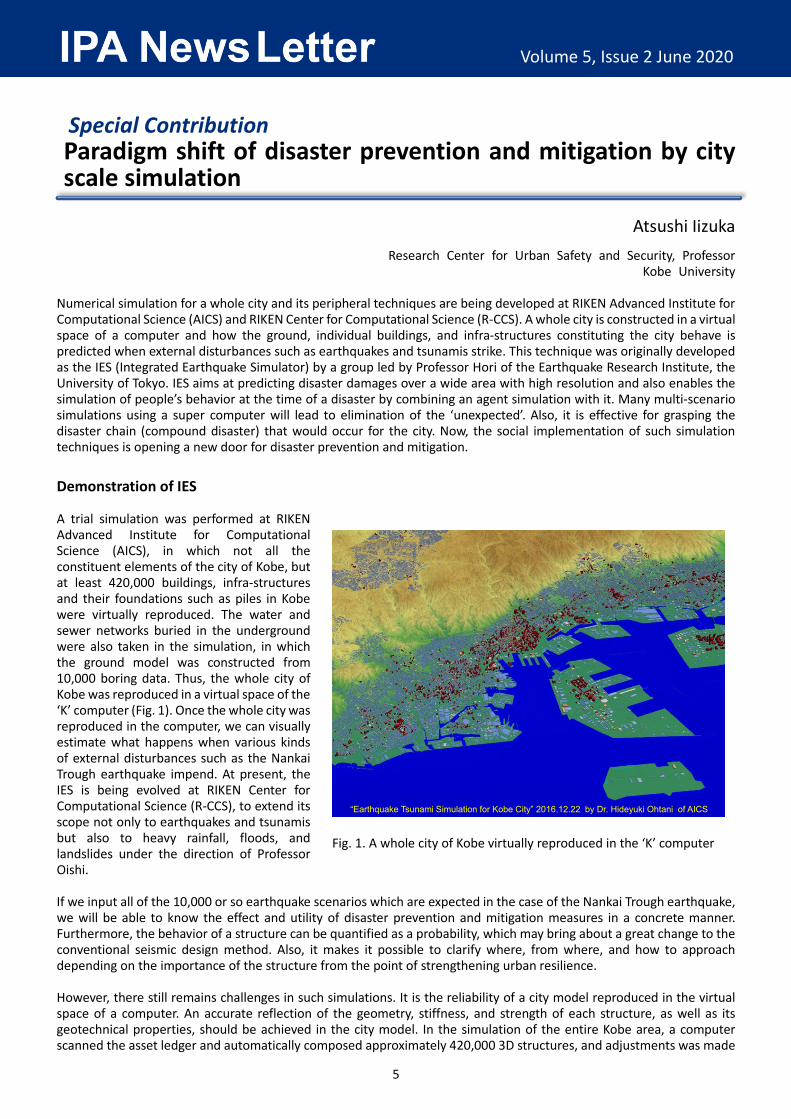
Numerical simulation for a whole city and its peripheral techniques are being developed at RIKEN Advanced Institute for Computational Science (AICS) and RIKEN Center for Computational Science (R-CCS). A whole city is constructed in a virtual space of a computer and how the ground, individual buildings, and infra-structures constituting the city behave is predicted when external disturbances such as earthquakes and tsunamis strike. This technique was originally developed as the IES (Integrated Earthquake Simulator) by a group led by Professor Hori of the Earthquake Research Institute, the University of Tokyo. IES aims at predicting disaster damages over a wide area with high resolution and also enables the simulation of people’s behavior at the time of a disaster by combining an agent simulation with it. Many multi-scenario simulations using a super computer will lead to elimination of the ‘unexpected’. Also, it is effective for grasping the disaster chain (compound disaster) that would occur for the city. Now, the social implementation of such simulation techniques is opening a new door for disaster prevention and mitigation. Demonstration of IES A trial simulation was performed at RIKEN Advanced Institute for Computational Science (AICS), in which not all the constituent elements of the city of Kobe, but at least 420,000 buildings, infra-structures and their foundations such as piles in Kobe were virtually reproduced. The water and sewer networks buried in the underground were also taken in the simulation, in which the ground model was constructed from 10,000 boring data. Thus, the whole city of Kobe was reproduced in a virtual space of the ‘K’ computer (Fig. 1). Once the whole city was reproduced in the computer, we can visually estimate what happens when various kinds of external disturbances such as the Nankai Trough earthquake impend. At present, the IES is being evolved at RIKEN Center for Computational Science (R-CCS), to extend its scope not only to earthquakes and tsunamis but also to heavy rainfall, floods, and landslides under the direction of Professor Oishi. If we input all of the 10,000 or so earthquake scenarios which are expected in the case of the Nankai Trough earthquake, we will be able to know the effect and utility of disaster prevention and mitigation measures in a concrete manner. Furthermore, the behavior of a structure can be quantified as a probability, which may bring about a great change to the conventional seismic design method. Also, it makes it possible to clarify where, from where, and how to approach depending on the importance of the structure from the point of strengthening urban resilience. However, there still remains challenges in such simulations. It is the reliability of a city model reproduced in the virtual space of a computer. An accurate reflection of the geometry, stiffness, and strength of each structure, as well as its geotechnical properties, should be achieved in the city model. In the simulation of the entire Kobe area, a computer scanned the asset ledger and automatically composed approximately 420,000 3D structures, and adjustments was made
Fig. 1. A whole city of Kobe virtually reproduced in the ‘K’ computer
“Earthquake Tsunami Simulation for Kobe City” 2016.12.22 by Dr. Hideyuki Ohtani of AICS
6
Volume 5, Issue 2 June 2020
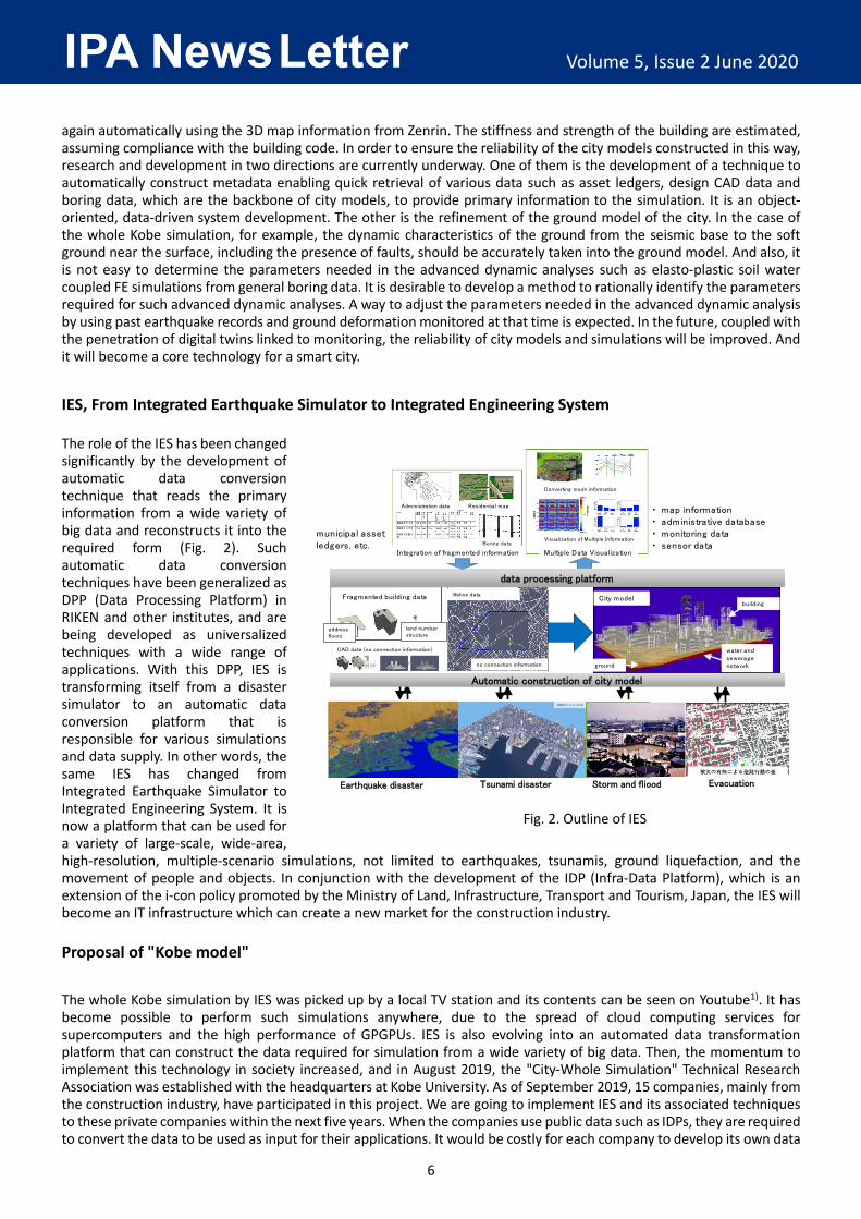
again automatically using the 3D map information from Zenrin. The stiffness and strength of the building are estimated, assuming compliance with the building code. In order to ensure the reliability of the city models constructed in this way, research and development in two directions are currently underway. One of them is the development of a technique to automatically construct metadata enabling quick retrieval of various data such as asset ledgers, design CAD data and boring data, which are the backbone of city models, to provide primary information to the simulation. It is an object-oriented, data-driven system development. The other is the refinement of the ground model of the city. In the case of the whole Kobe simulation, for example, the dynamic characteristics of the ground from the seismic base to the soft ground near the surface, including the presence of faults, should be accurately taken into the ground model. And also, it is not easy to determine the parameters needed in the advanced dynamic analyses such as elasto-plastic soil water coupled FE simulations from general boring data. It is desirable to develop a method to rationally identify the parameters required for such advanced dynamic analyses. A way to adjust the parameters needed in the advanced dynamic analysis by using past earthquake records and ground deformation monitored at that time is expected. In the future, coupled with the penetration of digital twins linked to monitoring, the reliability of city models and simulations will be improved. And it will become a core technology for a smart city. IES, From Integrated Earthquake Simulator to Integrated Engineering System The role of the IES has been changed significantly by the development of automatic data conversion technique that reads the primary information from a wide variety of big data and reconstructs it into the required form (Fig. 2). Such automatic data conversion techniques have been generalized as DPP (Data Processing Platform) in RIKEN and other institutes, and are being developed as universalized techniques with a wide range of applications. With this DPP, IES is transforming itself from a disaster simulator to an automatic data conversion platform that is responsible for various simulations and data supply. In other words, the same IES has changed from Integrated Earthquake Simulator to Integrated Engineering System. It is now a platform that can be used for a variety of large-scale, wide-area, high-resolution, multiple-scenario simulations, not limited to earthquakes, tsunamis, ground liquefaction, and the movement of people and objects. In conjunction with the development of the IDP (Infra-Data Platform), which is an extension of the i-con policy promoted by the Ministry of Land, Infrastructure, Transport and Tourism, Japan, the IES will become an IT infrastructure which can create a new market for the construction industry. Proposal of "Kobe model" The whole Kobe simulation by IES was picked up by a local TV station and its contents can be seen on Youtube1). It has become possible to perform such simulations anywhere, due to the spread of cloud computing services for supercomputers and the high performance of GPGPUs. IES is also evolving into an automated data transformation platform that can construct the data required for simulation from a wide variety of big data. Then, the momentum to implement this technology in society increased, and in August 2019, the "City-Whole Simulation" Technical Research Association was established with the headquarters at Kobe University. As of September 2019, 15 companies, mainly from the construction industry, have participated in this project. We are going to implement IES and its associated techniques to these private companies within the next five years. When the companies use public data such as IDPs, they are required to convert the data to be used as input for their applications. It would be costly for each company to develop its own data
Fig. 2. Outline of IES
Administration data Residential map
Boring data
Integration of fragmented information
Converting mesh information
Visualization of Multiple Information
Multiple Data Visualization
Earthquake disaster Tsunami disaster Storm and fliood
municipal asset ledgers, etc.
都市モデル建物
地盤 上水道管路
Evacuation
Automatic construction of city model
data processing platform
・ map information・ administrative database・ monitoring data・ sensor data
Fragmented building data
addressfloors
land numberstructure
CAD data (no connection information)
lifeline data
no connection information
City modelbuilding
water and sewerage networkground
7
Volume 5, Issue 2 June 2020
conversion technique. Therefore, we aim to generalize the required data conversion techniques as much as possible and construct a data conversion system that can be used widely.
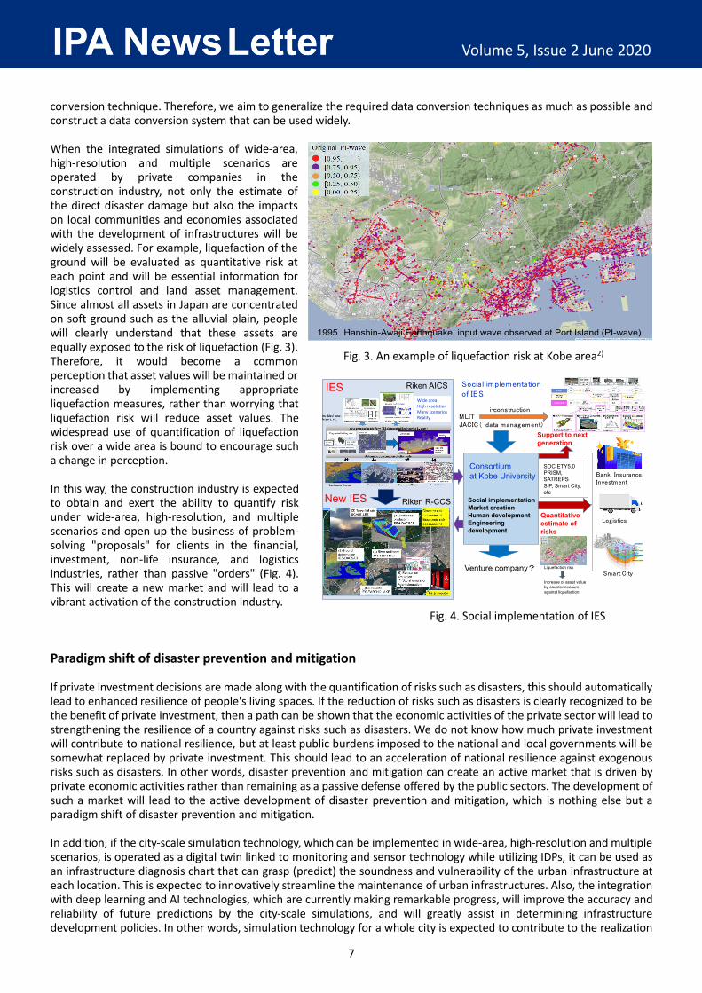
When the integrated simulations of wide-area, high-resolution and multiple scenarios are operated by private companies in the construction industry, not only the estimate of the direct disaster damage but also the impacts on local communities and economies associated with the development of infrastructures will be widely assessed. For example, liquefaction of the ground will be evaluated as quantitative risk at each point and will be essential information for logistics control and land asset management. Since almost all assets in Japan are concentrated on soft ground such as the alluvial plain, people will clearly understand that these assets are equally exposed to the risk of liquefaction (Fig. 3). Therefore, it would become a common perception that asset values will be maintained or increased by implementing appropriate liquefaction measures, rather than worrying that liquefaction risk will reduce asset values. The widespread use of quantification of liquefaction risk over a wide area is bound to encourage such a change in perception.
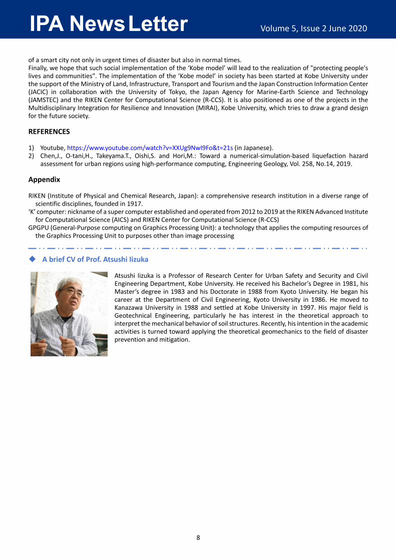
In this way, the construction industry is expected to obtain and exert the ability to quantify risk under wide-area, high-resolution, and multiple scenarios and open up the business of problem-solving "proposals" for clients in the financial, investment, non-life insurance, and logistics industries, rather than passive "orders" (Fig. 4). This will create a new market and will lead to a vibrant activation of the construction industry. Paradigm shift of disaster prevention and mitigation If private investment decisions are made along with the quantification of risks such as disasters, this should automatically lead to enhanced resilience of people's living spaces. If the reduction of risks such as disasters is clearly recognized to be the benefit of private investment, then a path can be shown that the economic activities of the private sector will lead to strengthening the resilience of a country against risks such as disasters. We do not know how much private investment will contribute to national resilience, but at least public burdens imposed to the national and local governments will be somewhat replaced by private investment. This should lead to an acceleration of national resilience against exogenous risks such as disasters. In other words, disaster prevention and mitigation can create an active market that is driven by private economic activities rather than remaining as a passive defense offered by the public sectors. The development of such a market will lead to the active development of disaster prevention and mitigation, which is nothing else but a paradigm shift of disaster prevention and mitigation.
In addition, if the city-scale simulation technology, which can be implemented in wide-area, high-resolution and multiple scenarios, is operated as a digital twin linked to monitoring and sensor technology while utilizing IDPs, it can be used as an infrastructure diagnosis chart that can grasp (predict) the soundness and vulnerability of the urban infrastructure at each location. This is expected to innovatively streamline the maintenance of urban infrastructures. Also, the integration with deep learning and AI technologies, which are currently making remarkable progress, will improve the accuracy and reliability of future predictions by the city-scale simulations, and will greatly assist in determining infrastructure development policies. In other words, simulation technology for a whole city is expected to contribute to the realization
Fig. 4. Social implementation of IES
IES
New IES Social implementationMarket creationHuman developmentEngineering development
Consortiumat Kobe University
Riken R-CCS
Venture company?
MLITJACIC( data management)
SOCIETY5.0PRISM, SATREPSSIP, Smart City, etc
Support to next generation
Bank, Insurance, Investment
Quantitative estimate of risks
Liquefaction risk
Increase of asset value by countermeasure against liquefaction
i-construction
Smart City
Social implementation of IES
Riken AICSWide areaHigh resolutionMany scenariosReality
Logistics
1995 Hanshin-Awaji Earthquake, input wave observed at Port Island (PI-wave)
Fig. 3. An example of liquefaction risk at Kobe area2)
8
Volume 5, Issue 2 June 2020
of a smart city not only in urgent times of disaster but also in normal times. Finally, we hope that such social implementation of the ‘Kobe model’ will lead to the realization of "protecting people's lives and communities". The implementation of the ‘Kobe model’ in society has been started at Kobe University under the support of the Ministry of Land, Infrastructure, Transport and Tourism and the Japan Construction Information Center (JACIC) in collaboration with the University of Tokyo, the Japan Agency for Marine-Earth Science and Technology (JAMSTEC) and the RIKEN Center for Computational Science (R-CCS). It is also positioned as one of the projects in the Multidisciplinary Integration for Resilience and Innovation (MIRAI), Kobe University, which tries to draw a grand design for the future society. REFERENCES 1) Youtube, https://www.youtube.com/watch?v=XXUg9NwI9Fo&t=21s (in Japanese). 2) Chen,J., O-tani,H., Takeyama.T., Oishi,S. and Hori,M.: Toward a numerical-simulation-based liquefaction hazard
assessment for urban regions using high-performance computing, Engineering Geology, Vol. 258, No.14, 2019. Appendix RIKEN (Institute of Physical and Chemical Research, Japan): a comprehensive research institution in a diverse range of
scientific disciplines, founded in 1917. ‘K’ computer: nickname of a super computer established and operated from 2012 to 2019 at the RIKEN Advanced Institute
for Computational Science (AICS) and RIKEN Center for Computational Science (R-CCS) GPGPU (General-Purpose computing on Graphics Processing Unit): a technology that applies the computing resources of
the Graphics Processing Unit to purposes other than image processing A brief CV of Prof. Atsushi Iizuka
Atsushi Iizuka is a Professor of Research Center for Urban Safety and Security and Civil Engineering Department, Kobe University. He received his Bachelor’s Degree in 1981, his Master’s degree in 1983 and his Doctorate in 1988 from Kyoto University. He began his career at the Department of Civil Engineering, Kyoto University in 1986. He moved to Kanazawa University in 1988 and settled at Kobe University in 1997. His major field is Geotechnical Engineering, particularly he has interest in the theoretical approach to interpret the mechanical behavior of soil structures. Recently, his intention in the academic activities is turned toward applying the theoretical geomechanics to the field of disaster prevention and mitigation.