Embed Size (px)
Citation preview
1
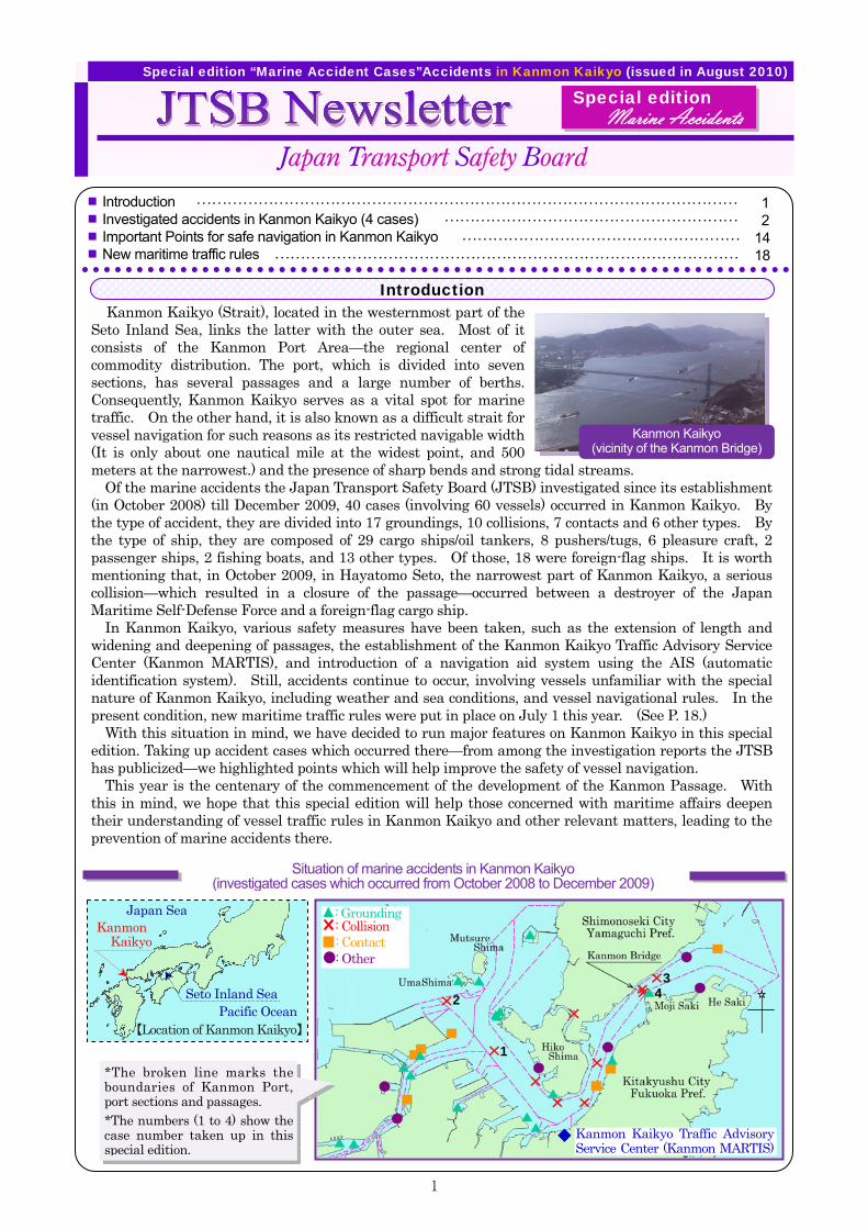
Kanmon Kaikyo (Strait), located in the westernmost part of the Seto Inland Sea, links the latter with the outer sea. Most of it consists of the Kanmon Port Area—the regional center of commodity distribution. The port, which is divided into seven sections, has several passages and a large number of berths. Consequently, Kanmon Kaikyo serves as a vital spot for marine traffic. On the other hand, it is also known as a difficult strait for vessel navigation for such reasons as its restricted navigable width (It is only about one nautical mile at the widest point, and 500 meters at the narrowest.) and the presence of sharp bends and strong tidal streams.
Of the marine accidents the Japan Transport Safety Board (JTSB) investigated since its establishment (in October 2008) till December 2009, 40 cases (involving 60 vessels) occurred in Kanmon Kaikyo. By the type of accident, they are divided into 17 groundings, 10 collisions, 7 contacts and 6 other types. By the type of ship, they are composed of 29 cargo ships/oil tankers, 8 pushers/tugs, 6 pleasure craft, 2 passenger ships, 2 fishing boats, and 13 other types. Of those, 18 were foreign-flag ships. It is worth mentioning that, in October 2009, in Hayatomo Seto, the narrowest part of Kanmon Kaikyo, a serious collision—which resulted in a closure of the passage—occurred between a destroyer of the Japan Maritime Self-Defense Force and a foreign-flag cargo ship.
In Kanmon Kaikyo, various safety measures have been taken, such as the extension of length and widening and deepening of passages, the establishment of the Kanmon Kaikyo Traffic Advisory Service Center (Kanmon MARTIS), and introduction of a navigation aid system using the AIS (automatic identification system). Still, accidents continue to occur, involving vessels unfamiliar with the special nature of Kanmon Kaikyo, including weather and sea conditions, and vessel navigational rules. In the present condition, new maritime traffic rules were put in place on July 1 this year. (See P. 18.)
With this situation in mind, we have decided to run major features on Kanmon Kaikyo in this special edition. Taking up accident cases which occurred there—from among the investigation reports the JTSB has publicized—we highlighted points which will help improve the safety of vessel navigation.
This year is the centenary of the commencement of the development of the Kanmon Passage. With this in mind, we hope that this special edition will help those concerned with maritime affairs deepen their understanding of vessel traffic rules in Kanmon Kaikyo and other relevant matters, leading to the prevention of marine accidents there.
Introduction Investigated accidents in Kanmon Kaikyo (4 cases) Important Points for safe navigation in Kanmon Kaikyo New maritime traffic rules
Japan Transport Safety Board
Special edition “Marine Accident Cases”Accidents in Kanmon Kaikyo (issued in August 2010)
Introduction
Situation of marine accidents in Kanmon Kaikyo (investigated cases which occurred from October 2008 to December 2009)
*The broken line marks the boundaries of Kanmon Port, port sections and passages. *The numbers (1 to 4) show the case number taken up in this special edition.
1
23
4
◆ Kanmon Kaikyo Traffic Advisory Service Center (Kanmon MARTIS)
■■ ■■ ■■ ■■
…………………………………………………………………………………………… …………………………………………………
……………………………………………… ………………………………………………………………………………
Special edition
1 2
14 18
: Grounding: Collision: Contact: Other
Kanmon Kaikyo (vicinity of the Kanmon Bridge)
Marine Accidents
Kanmon Kaikyo
Pacific Ocean
Japan Sea
Seto Inland Sea
【Location of Kanmon Kaikyo】
2
Gross tonnage : 1,312 tonsL × B × D : 73.00 m × 11.50 m × 7.00 m Flag state : The Kingdom of Cambodia Crew members, etc : Master B (of the People’s Republic of China) and 9 crew members Load condition : Graphite
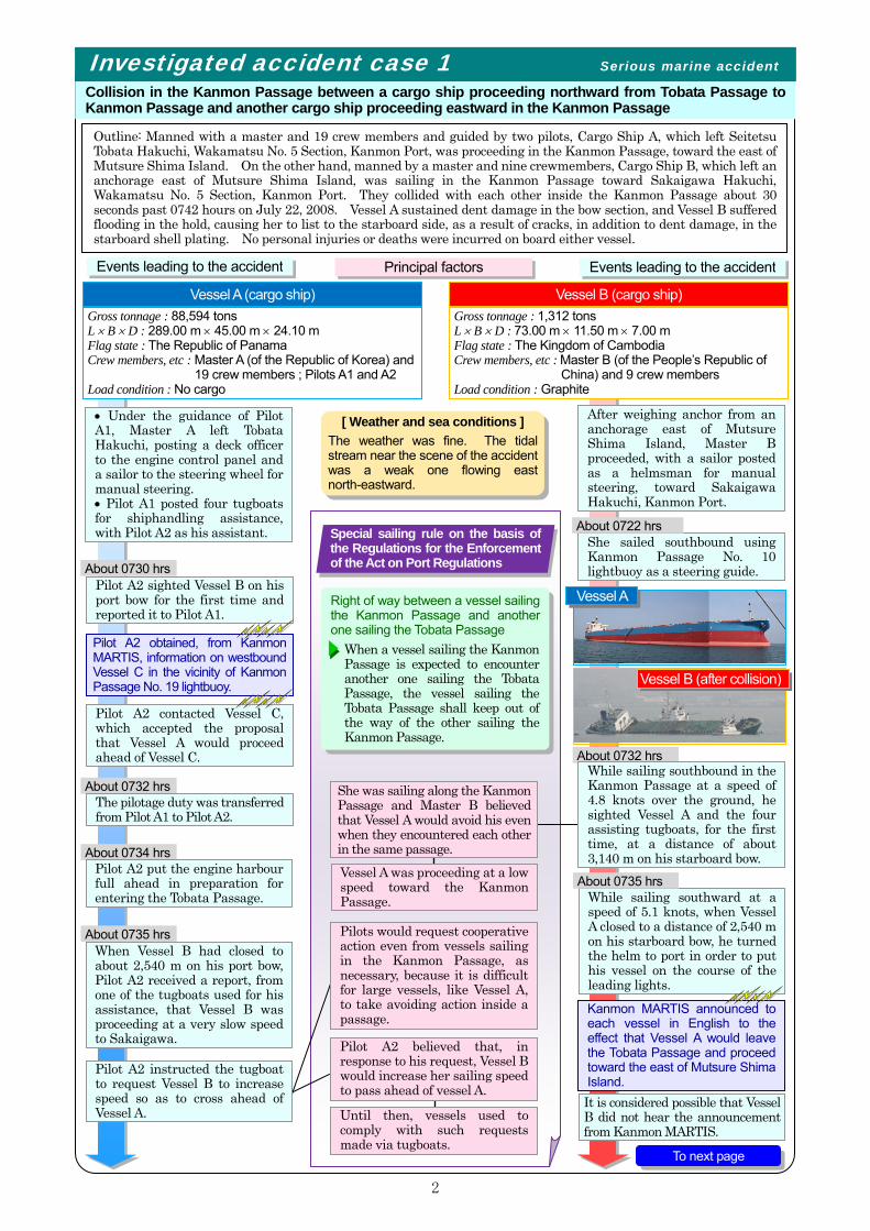
Outline: Manned with a master and 19 crew members and guided by two pilots, Cargo Ship A, which left Seitetsu Tobata Hakuchi, Wakamatsu No. 5 Section, Kanmon Port, was proceeding in the Kanmon Passage, toward the east of Mutsure Shima Island. On the other hand, manned by a master and nine crewmembers, Cargo Ship B, which left an anchorage east of Mutsure Shima Island, was sailing in the Kanmon Passage toward Sakaigawa Hakuchi, Wakamatsu No. 5 Section, Kanmon Port. They collided with each other inside the Kanmon Passage about 30 seconds past 0742 hours on July 22, 2008. Vessel A sustained dent damage in the bow section, and Vessel B suffered flooding in the hold, causing her to list to the starboard side, as a result of cracks, in addition to dent damage, in the starboard shell plating. No personal injuries or deaths were incurred on board either vessel.
Investigated accident case 1 Serious marine accident Collision in the Kanmon Passage between a cargo ship proceeding northward from Tobata Passage to Kanmon Passage and another cargo ship proceeding eastward in the Kanmon Passage
About 0730 hrs Pilot A2 sighted Vessel B on his port bow for the first time and reported it to Pilot A1.
• Under the guidance of Pilot A1, Master A left Tobata Hakuchi, posting a deck officer to the engine control panel and a sailor to the steering wheel for manual steering. • Pilot A1 posted four tugboats for shiphandling assistance, with Pilot A2 as his assistant.
Events leading to the accident Principal factors
Vessel B (cargo ship) Gross tonnage : 88,594 tons L × B × D : 289.00 m × 45.00 m × 24.10 m Flag state : The Republic of Panama Crew members, etc : Master A (of the Republic of Korea) and
19 crew members ; Pilots A1 and A2 Load condition : No cargo
Pilot A2 contacted Vessel C, which accepted the proposal that Vessel A would proceed ahead of Vessel C.
About 0732 hrs The pilotage duty was transferred from Pilot A1 to Pilot A2.
About 0734 hrs Pilot A2 put the engine harbour full ahead in preparation for entering the Tobata Passage.
About 0735 hrs When Vessel B had closed to about 2,540 m on his port bow, Pilot A2 received a report, from one of the tugboats used for his assistance, that Vessel B was proceeding at a very slow speed to Sakaigawa.
Vessel A (cargo ship)
She sailed southbound using Kanmon Passage No. 10 lightbuoy as a steering guide.
About 0722 hrs
While sailing southward at a speed of 5.1 knots, when Vessel A closed to a distance of 2,540 m on his starboard bow, he turned the helm to port in order to put his vessel on the course of the leading lights.
About 0735 hrs
Right of way between a vessel sailing the Kanmon Passage and another one sailing the Tobata Passage
When a vessel sailing the Kanmon Passage is expected to encounter another one sailing the Tobata Passage, the vessel sailing the Tobata Passage shall keep out of the way of the other sailing the Kanmon Passage.
Vessel A
Vessel A was proceeding at a low speed toward the Kanmon Passage.
Until then, vessels used to comply with such requests made via tugboats.
Pilot A2 believed that, in response to his request, Vessel B would increase her sailing speed to pass ahead of vessel A.
She was sailing along the Kanmon Passage and Master B believed that Vessel A would avoid his even when they encountered each other in the same passage.
Pilot A2 instructed the tugboat to request Vessel B to increase speed so as to cross ahead of Vessel A.
Pilots would request cooperative action even from vessels sailing in the Kanmon Passage, as necessary, because it is difficult for large vessels, like Vessel A, to take avoiding action inside a passage.
Kanmon MARTIS announced to each vessel in English to the effect that Vessel A would leave the Tobata Passage and proceed toward the east of Mutsure Shima Island. It is considered possible that Vessel B did not hear the announcement from Kanmon MARTIS.
Vessel B (after collision)
Events leading to the accident
[ Weather and sea conditions ] The weather was fine. The tidal stream near the scene of the accident was a weak one flowing east north-eastward.
Pilot A2 obtained, from Kanmon MARTIS, information on westbound Vessel C in the vicinity of Kanmon Passage No. 19 lightbuoy.
Special sailing rule on the basis of the Regulations for the Enforcement of the Act on Port Regulations
After weighing anchor from an anchorage east of Mutsure Shima Island, Master B proceeded, with a sailor posted as a helmsman for manual steering, toward Sakaigawa Hakuchi, Kanmon Port.
About 0732 hrs While sailing southbound in the Kanmon Passage at a speed of 4.8 knots over the ground, he sighted Vessel A and the four assisting tugboats, for the first time, at a distance of about 3,140 m on his starboard bow.
To next page
3
From previous page
About 0736 hrs
Pilot A2 took notice of a risk of collision with Vessel B and gave a warning signal on the whistle.
About 0741 hrs She entered the Kanmon Passage.
About 0739 hrs
Pilot A1 instructed one of the tugboats to request Vessel B to take all her way off by working the engine full astern and putting the rudder hard over to starboard.
About 0740 hrs - 0740.30hrs After putting the rudder hard over to port, Pilot A2 gave instructions to stop the engine.
About 0742.30 hrs On a heading of 019º and at an approximate speed of 7.2 knots, the bow of Vessel A collided with the starboard amidships section of Vessel B.
About 0736 hrs
About 0740 hrs
While sailing at an approximate speed of 5.2 knots, he increased the pitch from 16º to 20º for acceleration.
Vessel A entered the Tobata Passage.
With the presence of tidal streams from his port side, Pilot A2 made allowance for her drift to starboard. Pilot A2 took into account the fact that it was arranged for Vessel A to proceed ahead of westbound Vessel C.
Although he received a report from one of his tugboats that Vessel B was not increasing her speed, Pilot A2 still increased his own vessel speed.
Despite the increase of the pitch, she continued sailing at almost the same speed of 5.4 knots.
She was almost fully laden.Master A gave instructions to work the engine full astern, almost at the same time as Pilot A2 did so.
As a result of collision, she sustained a flooding in the cargo hold, forcing her to list to starboard.
Pilots A1 and A2 were not aware, at a stage before entering the Tobata Passage, of Vessel B approaching them while involving risk of encounter.
Vessel B, which was in sight under good visibility, accepted the request to increase her speed.
They did not attempt to get such information as Vessel B’s course, speed and name, by using the automatic radar plotting aid (ARPA) and the automatic identification system (AIS), nor communicate directly with her by VHF.
Master B did not slacken hisspeed or take all way off since he was increasing it in response to a request from one of the tugboats assisting Vessel A. Bearing in mind the presence of a lightbuoy on his starboard side and shallow waters outside the passage, Master B did not turn to starboard.
Although he received a request, from one of the tugboats, to work the engine full astern and put the rudder hard over to starboard, he put the rudder 30º to port when Vessel A had closed to a distance of about 670 m on his starboard bow.
Upon receiving a request —conveyed in English with a loudspeaker by an approaching tugboat for Vessel A — to immediately put the engine full ahead, he agreed to it.
Estimated Navigation Route
Location
About 0742.30 hrs On a heading of 084º and at an approximate speed of 4.2 knots, she collided with Vessel A.
About 0741 hrs

4
Ana l ys i s on th e a cc i d en t oc c ur r enc e
Master B
◆ Vessel A, which was sailing the Tobata Passage, was proceeding almost on a constant course while increasing her speed. Vessel B, which was following the Kanmon Passage, received a request to increase her speed, but could not comply with the request and sailed, in fact, maintaining the same speed and course, thus, resulting in both vessels approaching each other in such a manner as to involve risk of encounter inside the Kanmon Passage.
As Vessel B was sailing along the Kanmon Passage, Master B believed that, even in the case of an encounter with Vessel A in the same passage, Vessel A would keep out of his way.
Master A
Master A, who had entrusted the pilots with the con of his vessel, did not take a command appropriately.
→ Vessel A, which was sailing the Tobata Passage, was required, in accordance with the provisions of the Regulations for the Enforcement of the Act on Port Regulations, to keep out of the way of Vessel B, which was sailing the Kanmon Passage. In addition, as the ‘give-way vessel’, as specified in the Act on Preventing Collision at Sea, she was obliged to take, so far as possible, early and substantial action.
→ Vessel B, as the ‘stand-on vessel’, as specified in the Act on Preventing Collision at Sea, was obliged to keep her course and speed, and, in addition, she should have taken such action as would best aid to avoid collision if she had found herself so close that collision could not be avoided by the action of Vessel A alone.
Master B did not slow down nor take such action—e.g., taking all way off—as would best aid to avoid collision.
Pilot A2 continued accelerating his speed on the same course—without, e.g., substantially slackening his speed or taking way off, in ample time—not keeping out of the way of Vessel B, which involved a risk of a close encounter with her inside the Kanmon Passage.
Master B was not aware that Vessel A had developed a close-quarters situation and that collision could not be avoided by avoiding action on the Part of Vessel A alone.
Master B was in the process of speed increase in response to a request from Vessel A.
Pilot A2 continued increasing his speed, with the arrangement in mind that Vessel A was to proceed ahead of Vessel C, which was sailing westbound.
A2 A1
Pilot A2 believed that Vessel B would increase her speed, in response to his request, so as to pass ahead of his vessel.
《Pilotage and master’s authority to take command of the vessel in navigation》 ◆ In the Pilotage Act, if a pilot has reported to a vessel, the master of the vessel is required to have the pilot
guide her unless he has a justifiable reason to reject him. While his vessel is under the guidance of a pilot, the master is not supposed to construe that such act releases him, the master, from his responsibility to pursue safe navigation nor such act infringes upon his authority.
◆ In the Kanmon Straits & Harbour Pilot Association’s service provision contract, the pilot is defined as a person who is supposed to provide pilotage services in good faith in the capacity of an advisor to the master, and, his presence on board does not change the master’s authority or responsibility for safe navigation.
Pilots
In this accident, which occurred in Kanmon Port, it is considered probable that Vessel A—which was sailing northeastward from Tobata Passage to Kanmon Passage—did not keep out of the way of Vessel B—which was proceeding southeastward through the Kanmon Passage—when there was a risk of their encounter inside the Kanmon Passage, and continued increasing her speed while maintaining her course; and that Vessel B continued sailing almost at the same speed on a course almost along the general direction of the passage because she was not aware of the situation which required that she take action to avert collision since it could not be avoided by the action of Vessel A alone, which had already developed a close-quarters situation.
The report analyzes as follows about factors which contributed to the occurrence of the accident.
5
Analysis for the prevention of a recurrence of a similar accident
◆ The operation of a vessel is under the master’s authority and he is required to monitor, as the commander of his vessel, whether the pilot is maneuvering his vessel appropriately without jeopardizing the safety of navigation.
◆ In order for Master A to take the con for appropriate maneuvers, he was required to understand information provided by Kanmon MARTIS, communications with tugboats and Vessel C, and mutual conversation between the pilots. For that purpose, the pilots should have given such information to Master A, as necessary. ◆ It is effective for pilots to communicate with other vessels via assisting tugboats. However, it is sometimes desirable for both vessels to communicate directly via VHF, as necessary so that pilots fully understand a foreign vessel’s intention and avoid any misunderstanding, which can be caused by transferring messages.
The investigation report of this accident is publicized on the website of the JTSB(issued on May.28, 2010)
http://www.mlit.go.jp/jtsb/ship/report/MA2010-5-1_2008tk0003.pdf (Japanese version only)
W ith a v iew to p r even t in g r ec u r r enc e The JTSB has conducted the following analysis with a view to preventing a recurrence of a similar accident.
◆Important points for safe navigation in the western section of Kanmon Kaikyo are shown on Page 14.
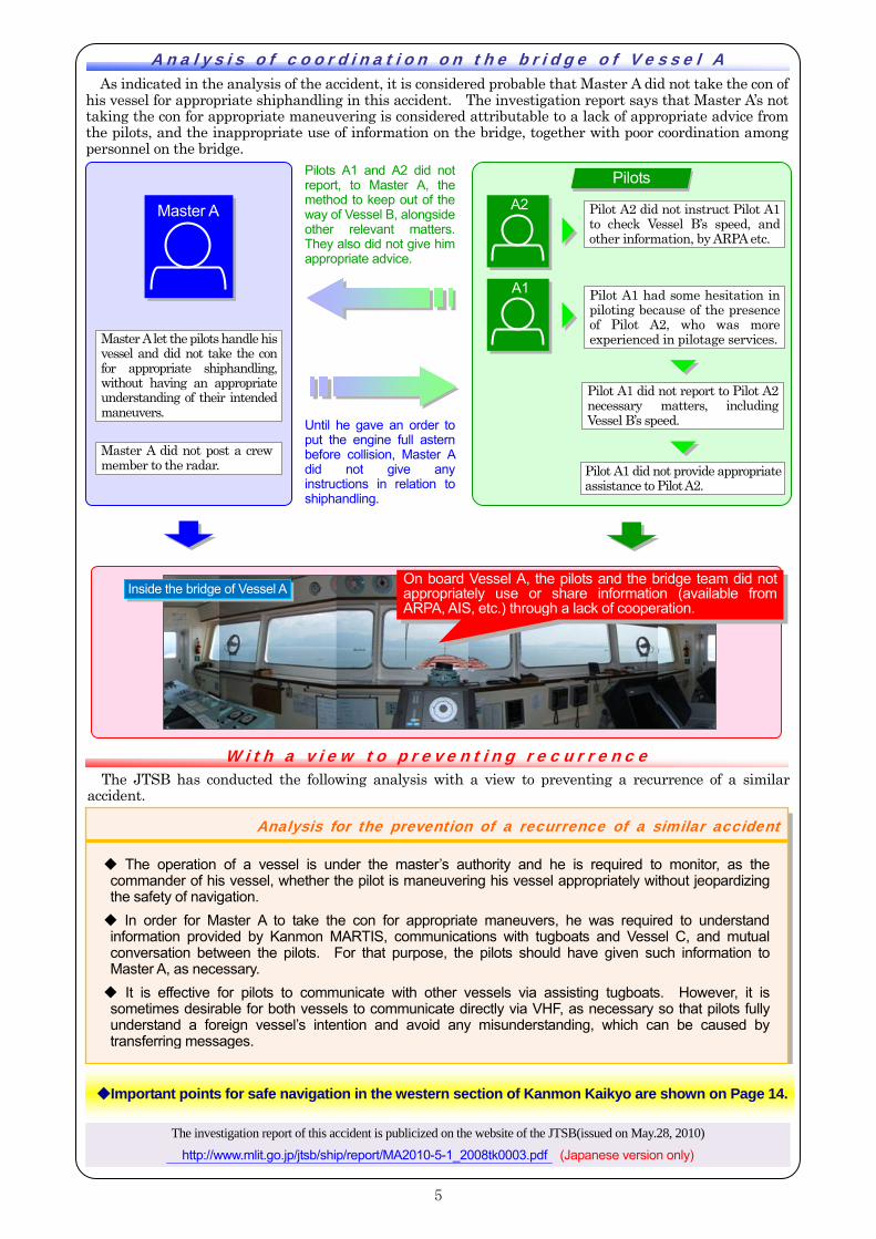
Pilot A1 did not provide appropriate assistance to Pilot A2.
Until he gave an order to put the engine full astern before collision, Master A did not give any instructions in relation to shiphandling.
Master A let the pilots handle his vessel and did not take the con for appropriate shiphandling, without having an appropriate understanding of their intended maneuvers.
Pilots A1 and A2 did notreport, to Master A, the method to keep out of the way of Vessel B, alongside other relevant matters. They also did not give him appropriate advice.
An a l ys i s o f co o r d i nat i on on the b r i d ge o f Vesse l A As indicated in the analysis of the accident, it is considered probable that Master A did not take the con of
his vessel for appropriate shiphandling in this accident. The investigation report says that Master A’s not taking the con for appropriate maneuvering is considered attributable to a lack of appropriate advice from the pilots, and the inappropriate use of information on the bridge, together with poor coordination among personnel on the bridge.
Master A A2
A1
Pilot A2 did not instruct Pilot A1 to check Vessel B’s speed, and other information, by ARPA etc.
Pilot A1 did not report to Pilot A2 necessary matters, including Vessel B’s speed.
Pilots
Master A did not post a crew member to the radar.
Inside the bridge of Vessel A On board Vessel A, the pilots and the bridge team did not appropriately use or share information (available from ARPA, AIS, etc.) through a lack of cooperation.
Pilot A1 had some hesitation in piloting because of the presence of Pilot A2, who was more experienced in pilotage services.
6
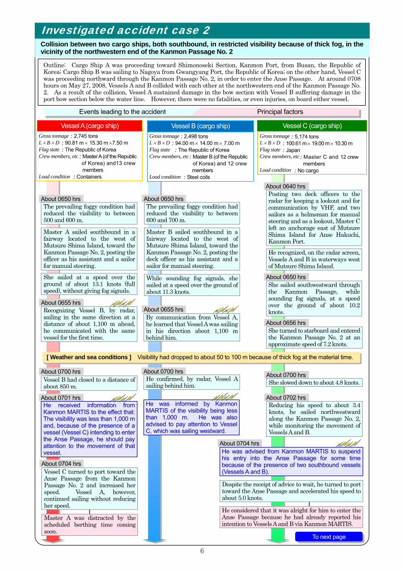
Outline: Cargo Ship A was proceeding toward Shimonoseki Section, Kanmon Port, from Busan, the Republic of Korea; Cargo Ship B was sailing to Nagoya from Gwangyang Port, the Republic of Korea; on the other hand, Vessel C was proceeding northward through the Kanmon Passage No. 2, in order to enter the Anse Passage. At around 0708 hours on May 27, 2008, Vessels A and B collided with each other at the northwestern end of the Kanmon Passage No. 2. As a result of the collision, Vessel A sustained damage in the bow section with Vessel B suffering damage in the port bow section below the water line. However, there were no fatalities, or even injuries, on board either vessel.
Investigated accident case 2 Collision between two cargo ships, both southbound, in restricted visibility because of thick fog, in the vicinity of the northwestern end of the Kanmon Passage No. 2
About 0650 hrs The prevailing foggy condition had reduced the visibility to between 500 and 600 m.
Posting two deck officers to the radar for keeping a lookout and for communication by VHF, and two sailors as a helmsman for manual steering and as a lookout, Master C left an anchorage east of Mutsure Shima Island for Anse Hakuchi, Kanmon Port.
Master A sailed southbound in a fairway located to the west of Mutsure Shima Island, toward the Kanmon Passage No. 2, posting the officer as his assistant and a sailor for manual steering.
She sailed at a speed over the ground of about 13.1 knots (full speed), without giving fog signals.
About 0650 hrsThe prevailing foggy condition had reduced the visibility to between 600 and 700 m.
Master B sailed southbound in a fairway located to the west of Mutsure Shima Island, toward the Kanmon Passage No. 2, posting the deck officer as his assistant and a sailor for manual steering.
While sounding fog signals, she sailed at a speed over the ground of about 11.3 knots.
She sailed southwestward through the Kanmon Passage, while sounding fog signals, at a speed over the ground of about 10.2 knots.
About 0640 hrs
He recognized, on the radar screen, Vessels A and B in waterways west of Mutsure Shima Island.
About 0650 hrs
About 0655 hrs Recognizing Vessel B, by radar, sailing in the same direction at a distance of about 1,100 m ahead, he communicated with the same vessel for the first time.
About 0700 hrs Vessel B had closed to a distance of about 850 m.
About 0701 hrs He received information from Kanmon MARTIS to the effect that: The visibility was less than 1,000 m and, because of the presence of a vessel (Vessel C) intending to enter the Anse Passage, he should pay attention to the movement of that vessel.
About 0655 hrsBy communication from Vessel A, he learned that Vessel A was sailing in his direction about 1,100 m behind him.
About 0700 hrsHe confirmed, by radar, Vessel A sailing behind him.
He was informed by Kanmon MARTIS of the visibility being less than 1,000 m. He was also advised to pay attention to Vessel C, which was sailing westward.
About 0656 hrs She turned to starboard and entered the Kanmon Passage No. 2 at an approximate speed of 7.2 knots.
About 0700 hrs She slowed down to about 4.8 knots.
About 0702 hrs Reducing his speed to about 3.4 knots, he sailed northwestward along the Kanmon Passage No. 2, while monitoring the movement of Vessels A and B.
About 0704 hrsHe was advised from Kanmon MARTIS to suspend his entry into the Anse Passage for some time because of the presence of two southbound vessels (Vessels A and B).
[ Weather and sea conditions ] Visibility had dropped to about 50 to 100 m because of thick fog at the material time.
Master A was distracted by the scheduled berthing time coming soon.
Despite the receipt of advice to wait, he turned to port toward the Anse Passage and accelerated his speed to about 5.0 knots.
He considered that it was alright for him to enter the Anse Passage because he had already reported his intention to Vessels A and B via Kanmon MARTIS.
About 0704 hrs Vessel C turned to port toward the Anse Passage from the Kanmon Passage No. 2 and increased her speed. Vessel A, however, continued sailing without reducing her speed.
Events leading to the accident Principal factors
To next page
Gross tonnage L × B × D Flag state Crew members, etc Load condition
Vessel B (cargo ship) : 2,498 tons
: 94.00 m × 14.00 m × 7.00 m : The Republic of Korea
: Master B (of the Republic of Korea) and 12 crew members
: Steel coils
Vessel A (cargo ship) Gross tonnage L × B × D Flag state Crew members, etc Load condition
: 2,745 tons : 90.81 m × 15.30 m ×7.50 m : The Republic of Korea
: Master A (of the Republic of Korea) and13 crew members
: Containers
Gross tonnage L × B × D Flag state Crew members, etc Load condition
Vessel C (cargo ship) : 5,174 tons
: 100.61 m × 19.00 m × 10.30 m : Japan
: Master C and 12 crew members
: No cargo
7
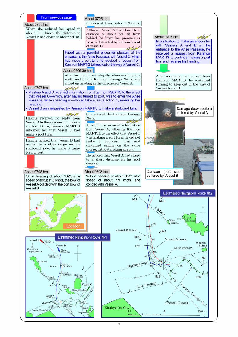
About 0705 hrs
About 0708 hrs On a heading of about 132º, at a speed of about 11.8 knots, the bow of Vessel A collided with the port bow of Vessel B.
Having noticed that Vessel B had neared to a close range on his starboard side, he made a large turn to port.
About 0705 hrs
About 0707 hrs
Having received no reply from Vessel B to their request to make a starboard turn, Kanmon MARTIS informed her that Vessel C had made a port turn.
Although he received information from Vessel A, following Kanmon MARTIS, to the effect that Vessel C was making a port turn, he did not make a starboard turn and continued sailing on the same course, without making a reply. He noticed that Vessel A had closed to a short distance on his port quarter.
About 0708 hrsWith a heading of about 081º, at a speed of about 7.9 knots, she collided with Vessel A.
Damage (bow section) suffered by Vessel A
Damage (port side) suffered by Vessel B
About 0706.30 hrs
About 0706 hrs In a situation to make an encounter with Vessels A and B at the entrance to the Anse Passage, he received a request from Kanmon MARTIS to continue making a port turn and reverse his heading.
She entered the Kanmon Passage No. 2.
After accepting the request from Kanmon MARTIS, he continued turning to keep out of the way of Vessels A and B.
When she reduced her speed to about 12.1 knots, the distance to Vessel B had closed to about 550 m.
After turning to port, slightly before reaching the north end of the Kanmon Passage No. 2, she ended up heading in the direction of Vessel A.
Although Vessel A had closed to a distance of about 550 m from behind, he forgot her presence as he was distracted by the movement of Vessel C.
She slowed down to about 9.9 knots.
• Masters A and B received information from Kanmon MARTIS to the effect that Vessel C—which, after having turned to port, was to enter the Anse Passage, while speeding up—would take evasive action by reversing her heading.
• Vessel B was requested by Kanmon MARTIS to make a starboard turn.
Faced with a potential encounter situation, at the entrance to the Anse Passage, with Vessel C, which had made a port turn, he received a request from Kanmon MARTIS to keep out of the way of Vessel C.
From previous page
Location
Estimated Navigation Route №1
Estimated Navigation Route №2
8
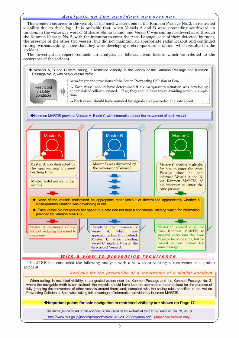
This accident occurred in the vicinity of the northwestern end of the Kanmon Passage No. 2, in restricted visibility due to thick fog. It is probable that, when Vessels A and B were proceeding southward, in tandem, in the waterway west of Mutsure Shima Island, and Vessel C was sailing northwestward through the Kanmon Passage No. 2, with the intention to enter the Anse Passage, each of them detected, by radar, the presence of the other two vessels, but did not maintain an appropriate radar lookout and continued sailing, without taking notice that they were developing a close-quarters situation, which resulted in the accident.
The investigation report conducts an analysis, as follows, about factors which contributed to the occurrence of the accident.
Ana l ys i s on th e a cc i d en t oc c ur r enc e
Analysis for the prevention of a recurrence of a similar accident
When sailing, in restricted visibility, in congested waters near the Kanmon Passage and the Kanmon Passage No. 2, where the navigable width is constrained, the vessels should have kept an appropriate radar lookout for the purpose of fully grasping the movement of other vessels around them, and, complied with the sailing rules specified in the Act on Preventing Collision at Sea, while taking full advantage of information provided by Kanmon MARTIS.
The investigation report of this accident is publicized on the website of the JTSB (issued on Jan. 29, 2010). http://www.mlit.go.jp/jtsb/ship/report/MA2010-1-29_2008mj0006.pdf (Japanese version only)
Master C Master B
◆ Vessels A, B and C were sailing, in restricted visibility, in the vicinity of the Kanmon Passage and KanmonPassage No. 2, with heavy vessel traffic.
Master B was distracted by the movement of Vessel C.
Master C decided it alright for him to enter the Anse Passage since he had informed Vessels A and B, via Kanmon MARTIS, of his intention to enter the Anse passage.
W ith a v iew to p r even t in g r ec u r r enc e
◆Kanmon MARTIS provided Vessels A, B and C with information about the movement of each vessel.
Master A
Master A was distracted by the approaching planned berthing time.
◆ None of the vessels maintained an appropriate radar lookout or determined approoriately whether a close-quarters situation was developing or not.
◆ Each vessel did not reduce her speed to a safe one nor kept a continuous listening watch for information
provided by Kanmon MARTIS.
Forgetting the presence of Vessel A, which was approaching him from behind, Master B, when avoiding Vessel C, made a turn in the direction of Vessel A.
Master C received a request from Kanmon MARTIS to suspend entry into the Anse Passage for some time, but he turned to port toward the same passage.
Master A continued sailing, without reducing his speed to a safe one.
According to the provisions of the Act on Preventing Collision at Sea: → Each vessel should have determined if a close-quarters situation was developing and/or risk of collision existed. If so, they should have taken avoiding action in ample time. → Each vessel should have sounded fog signals and proceeded at a safe speed.
Master A did not sound fog signals.
◆Important points for safe navigation in restricted visibility are shown on Page 17.
The JTSB has conducted the following analysis with a view to preventing a recurrence of a similar accident.
Restricted visibility
condition
9
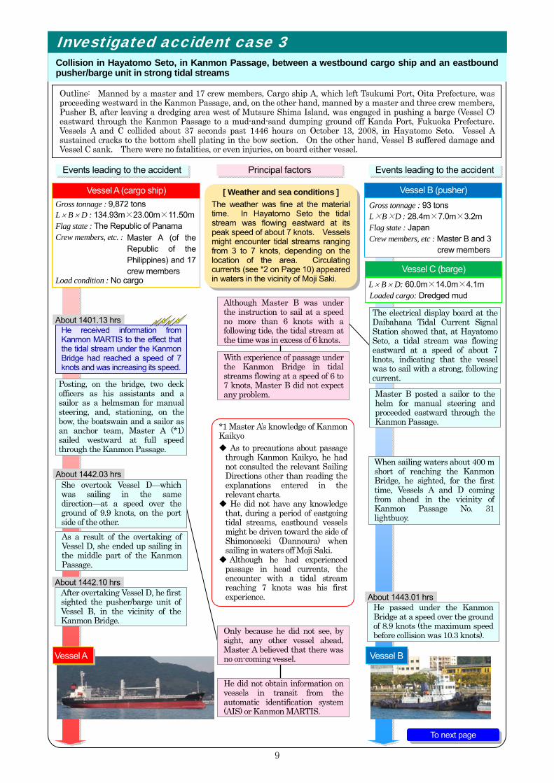
Outline: Manned by a master and 17 crew members, Cargo ship A, which left Tsukumi Port, Oita Prefecture, was proceeding westward in the Kanmon Passage, and, on the other hand, manned by a master and three crew members, Pusher B, after leaving a dredging area west of Mutsure Shima Island, was engaged in pushing a barge (Vessel C) eastward through the Kanmon Passage to a mud-and-sand dumping ground off Kanda Port, Fukuoka Prefecture. Vessels A and C collided about 37 seconds past 1446 hours on October 13, 2008, in Hayatomo Seto. Vessel A sustained cracks to the bottom shell plating in the bow section. On the other hand, Vessel B suffered damage and Vessel C sank. There were no fatalities, or even injuries, on board either vessel.
Investigated accident case 3
Collision in Hayatomo Seto, in Kanmon Passage, between a westbound cargo ship and an eastbound pusher/barge unit in strong tidal streams
Posting, on the bridge, two deck officers as his assistants and a sailor as a helmsman for manual steering, and, stationing, on the bow, the boatswain and a sailor as an anchor team, Master A (*1) sailed westward at full speed through the Kanmon Passage.
Master B posted a sailor to the helm for manual steering and proceeded eastward through the Kanmon Passage.
Events leading to the accident Principal factors Events leading to the accident
About 1442.03 hrs
About 1442.10 hrs After overtaking Vessel D, he first sighted the pusher/barge unit of Vessel B, in the vicinity of the Kanmon Bridge.
About 1443.01 hrs
When sailing waters about 400 m short of reaching the Kanmon Bridge, he sighted, for the first time, Vessels A and D coming from ahead in the vicinity of Kanmon Passage No. 31 lightbuoy.
[ Weather and sea conditions ] The weather was fine at the material time. In Hayatomo Seto the tidal stream was flowing eastward at its peak speed of about 7 knots. Vessels might encounter tidal streams ranging from 3 to 7 knots, depending on the location of the area. Circulating currents (see *2 on Page 10) appeared in waters in the vicinity of Moji Saki.
She overtook Vessel D—which was sailing in the same direction—at a speed over the ground of 9.9 knots, on the port side of the other.
He did not obtain information on vessels in transit from the automatic identification system (AIS) or Kanmon MARTIS.
Only because he did not see, by sight, any other vessel ahead, Master A believed that there was no on-coming vessel.
He passed under the Kanmon Bridge at a speed over the ground of 8.9 knots (the maximum speed before collision was 10.3 knots).
*1 Master A’s knowledge of Kanmon Kaikyo ◆ As to precautions about passage
through Kanmon Kaikyo, he had not consulted the relevant Sailing Directions other than reading the explanations entered in the relevant charts.
◆ He did not have any knowledge that, during a period of eastgoing tidal streams, eastbound vessels might be driven toward the side of Shimonoseki (Dannoura) when sailing in waters off Moji Saki.
◆ Although he had experienced passage in head currents, the encounter with a tidal stream reaching 7 knots was his first experience.
He received information from Kanmon MARTIS to the effect that the tidal stream under the Kanmon Bridge had reached a speed of 7 knots and was increasing its speed.
About 1401.13 hrs
Vessel A Vessel B
As a result of the overtaking of Vessel D, she ended up sailing in the middle part of the Kanmon Passage.
Although Master B was under the instruction to sail at a speed no more than 6 knots with a following tide, the tidal stream at the time was in excess of 6 knots.
With experience of passage under the Kanmon Bridge in tidal streams flowing at a speed of 6 to 7 knots, Master B did not expect any problem.
The electrical display board at the Daibahana Tidal Current Signal Station showed that, at Hayatomo Seto, a tidal stream was flowing eastward at a speed of about 7 knots, indicating that the vessel was to sail with a strong, following current.
Vessel A (cargo ship) Gross tonnage : 93 tons L×B×D : 28.4m×7.0m×3.2m Flag state : Japan Crew members, etc : Master B and 3
crew members
Vessel B (pusher)
L × B × D: 60.0m×14.0m×4.1m Loaded cargo: Dredged mud
Vessel C (barge)
To next page
Gross tonnage : 9,872 tons L × B × D : 134.93m×23.00m×11.50m Flag state : The Republic of Panama Crew members, etc. : Load condition : No cargo
Master A (of the Republic of the Philippines) and 17 crew members
10
About 1446.15 hrs When Vessel A closed to a distance of about 300 m, she worked the engine full astern while giving sound signals on the whistle.
About 1446.37 hrs On a heading of 106º and a course over the ground of 53.4º, at a speed of 7.5 knots, Vessel C collided with Vessel A.
About 1446.02 hrs She stopped the engine.
About 1446.03 hrs - 1446.11 hrs
About 1446.37 hrs On a heading in a range from 232º to 236º at a speed of 8 to 9 knots, the bow of Vessel A collided with the port side of Vessel C.
With Vessel D close to his starboard quarter, he did not have the freedom to put the rudder to starboard.
With a strong, head current, he did not keep a sufficient distance away from Vessel D.
Despite his effort to put the rudder hard over to starboard, his vessel did not respond to it and the pusher/barge unit of Vessel B was drawing closer and closer from dead ahead.
Master A intended to pass Vessel B (integrated pusher/barge unit) starboard to starboard.
Sensing a danger of collision with Vessel A, Master B put the rudder hard over to starboard.
Her starboard turn off Moji Saki was too late.
He paid attention not to enter an area of circulating currents (*2) which would make course-keeping difficult.
Vessel B was sailing near the center line of the Kanmon Passage.
*3 Provision of information by Kanmon MARTIS ◆ When the velocity of the tidal stream in Kanmon Kaikyo is equal to or more than 7
knots, Kanmon MARTIS broadcasts, by VHF, at intervals of 30 minutes, general information about tidal streams which may affect vessels to sheer.
About 12 seconds past 1446 hours, Kanmon MARTIS requested vessels in transit to change the VHF channel in order to announce, in English, information on the strong tidal stream in Hayatomo Seto.( *3)
She was driven by the strong, following tidal stream.
With the pusher/barge unit of Vessel B closing to a distance of about 400 m, he stopped starboarding and reversed the helm hard over to port.
About 3 seconds past 1442 hours, Vessel A overtook Vessel D on the port side of the latter.
*2 The Sailing Directions for Seto Naikai (issued in March 2009 by Japan Coast Guard) says: A circular flowing current is formed south of a line connecting Moji Saki and Kanmon Passage No. 32 lightbuoy and, during the period of an eastgoing tidal stream, east-bound vessels with the intention to approach Tanoura Wharf may find it difficult to maintain their course since they may take a sheer to starboard when the bow section is exposed to this circular flowing current.
Thinking that there was a danger of collision with the pusher/barge unit of Vessel B, Master A put the rudder hard over to starboard.
About 1445.55 hrs
《Tidal stream at Hayatomo Seto》
Eastgoing current of about 7 knots
Sinking Vessel C
Location
Estimated Navigation Route
From previous page
11
This accident occurred between westbound Vessel A and the eastbound pusher/barge unit of Vessel B in Hayatomo Seto, Kanmon Passage, when an eastgoing tidal stream was flowing at a speed of about 7 knots.
It is considered probable that Vessel A, which overtook Vessel D, and the pusher/barge unit of Vessel B, which was driven away from her course by strong tidal streams, were forced to sail in the middle part of the passage, resulting in their inability to keep out of the way of the other.
The JTSB has conducted the following analysis with a view to preventing a recurrence of a similar accident.
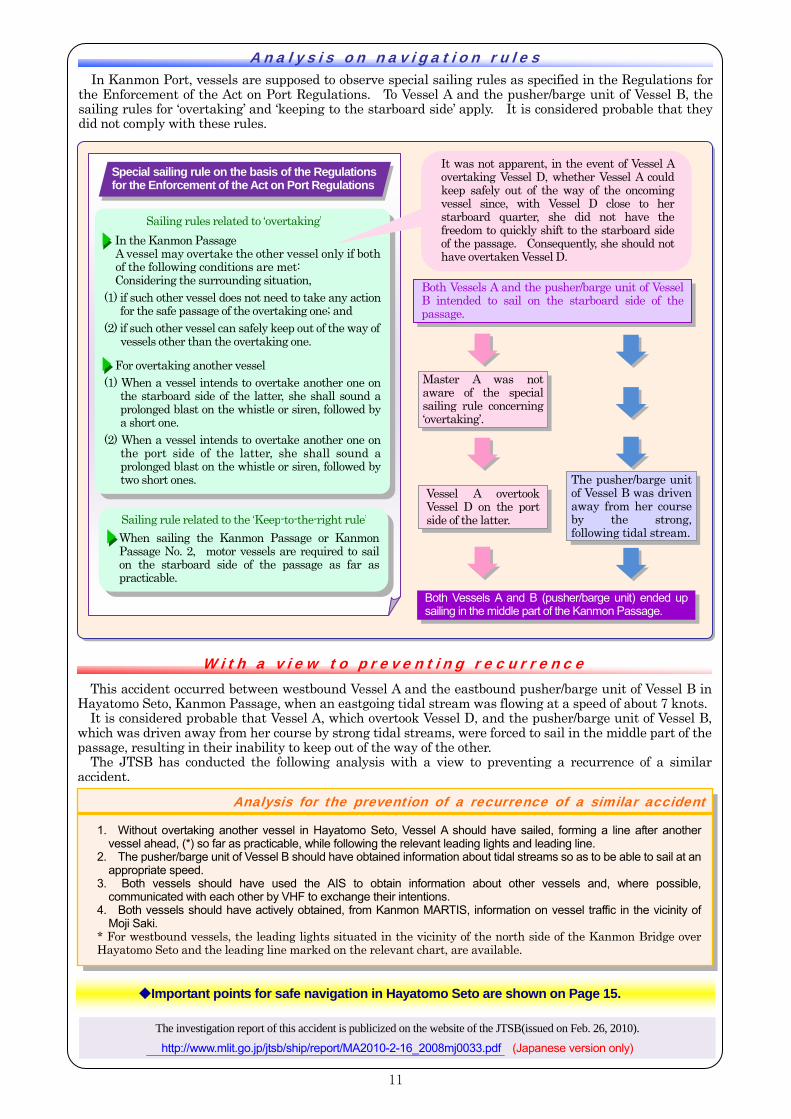
Ana l ys i s on nav igat io n r u les In Kanmon Port, vessels are supposed to observe special sailing rules as specified in the Regulations for
the Enforcement of the Act on Port Regulations. To Vessel A and the pusher/barge unit of Vessel B, the sailing rules for ‘overtaking’ and ‘keeping to the starboard side’ apply. It is considered probable that they did not comply with these rules.
W ith a v iew to p r even t in g r ec u r r enc e
Analysis for the prevention of a recurrence of a similar accident
1. Without overtaking another vessel in Hayatomo Seto, Vessel A should have sailed, forming a line after another vessel ahead, (*) so far as practicable, while following the relevant leading lights and leading line.
2. The pusher/barge unit of Vessel B should have obtained information about tidal streams so as to be able to sail at an appropriate speed.
3. Both vessels should have used the AIS to obtain information about other vessels and, where possible, communicated with each other by VHF to exchange their intentions.
4. Both vessels should have actively obtained, from Kanmon MARTIS, information on vessel traffic in the vicinity of Moji Saki.
* For westbound vessels, the leading lights situated in the vicinity of the north side of the Kanmon Bridge over Hayatomo Seto and the leading line marked on the relevant chart, are available.
The investigation report of this accident is publicized on the website of the JTSB(issued on Feb. 26, 2010). http://www.mlit.go.jp/jtsb/ship/report/MA2010-2-16_2008mj0033.pdf (Japanese version only)
◆Important points for safe navigation in Hayatomo Seto are shown on Page 15.
Sailing rules related to ‘overtaking’ In the Kanmon PassageA vessel may overtake the other vessel only if bothof the following conditions are met: Considering the surrounding situation,
(1) if such other vessel does not need to take any action for the safe passage of the overtaking one; and
(2) if such other vessel can safely keep out of the way of vessels other than the overtaking one.
For overtaking another vessel
(1) When a vessel intends to overtake another one on the starboard side of the latter, she shall sound a prolonged blast on the whistle or siren, followed by a short one.
(2) When a vessel intends to overtake another one on the port side of the latter, she shall sound aprolonged blast on the whistle or siren, followed bytwo short ones.
Sailing rule related to the ‘Keep-to-the-right rule’ When sailing the Kanmon Passage or Kanmon Passage No. 2, motor vessels are required to sail on the starboard side of the passage as far as practicable.
Master A was not aware of the special sailing rule concerning ‘overtaking’.
Vessel A overtook Vessel D on the port side of the latter.
The pusher/barge unit of Vessel B was driven away from her course by the strong, following tidal stream.
Both Vessels A and the pusher/barge unit of Vessel B intended to sail on the starboard side of the passage.
Both Vessels A and B (pusher/barge unit) ended up sailing in the middle part of the Kanmon Passage.
It was not apparent, in the event of Vessel A overtaking Vessel D, whether Vessel A could keep safely out of the way of the oncoming vessel since, with Vessel D close to her starboard quarter, she did not have the freedom to quickly shift to the starboard side of the passage. Consequently, she should not have overtaken Vessel D.
Special sailing rule on the basis of the Regulations for the Enforcement of the Act on Port Regulations
12
In the event of a visibility reduced to 1,000 m or less, the master shall: ◆ reduce his vessel speed to a safe one appropriate to the situation; and ◆ take measures, as necessary, such as taking all way off, anchoring outside
buoyed channels, or changing the sailing route.
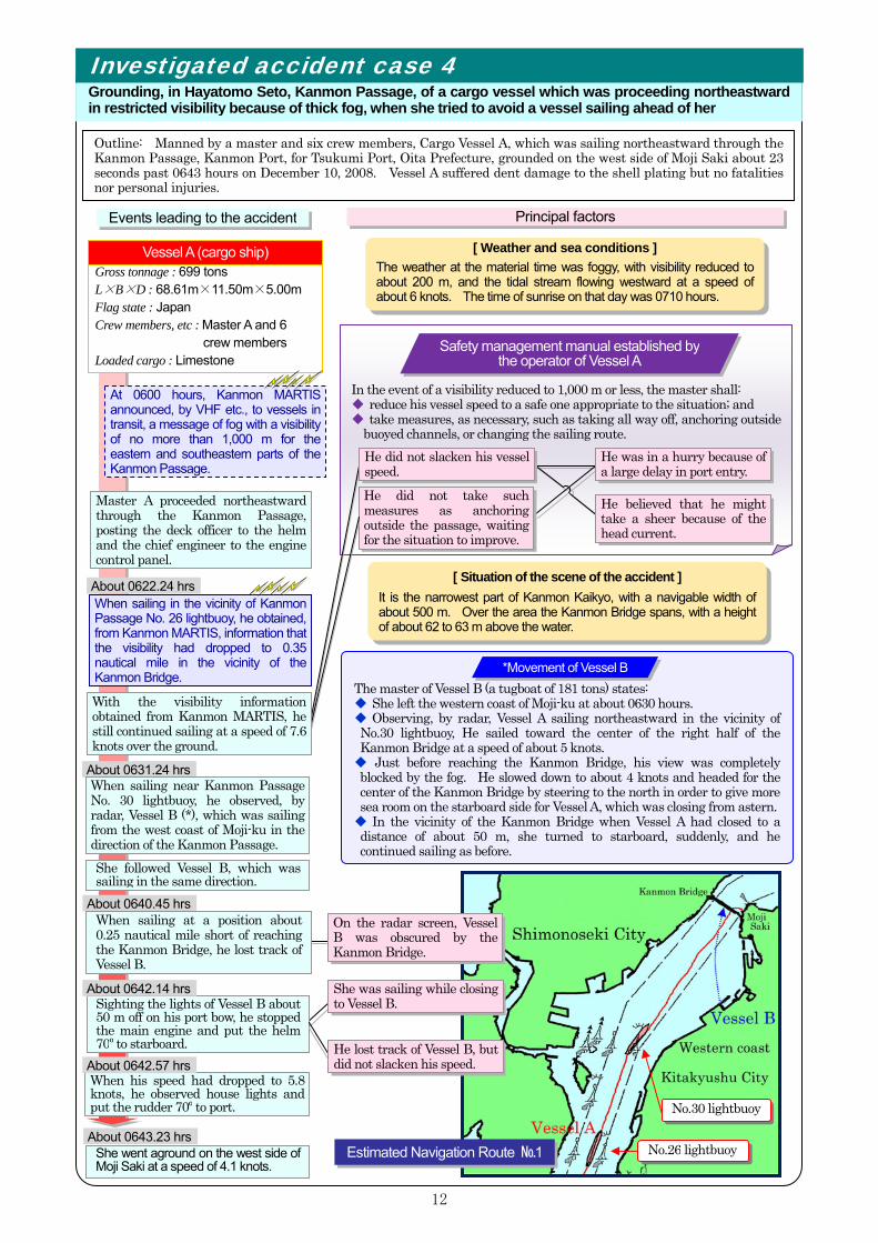
Outline: Manned by a master and six crew members, Cargo Vessel A, which was sailing northeastward through the Kanmon Passage, Kanmon Port, for Tsukumi Port, Oita Prefecture, grounded on the west side of Moji Saki about 23 seconds past 0643 hours on December 10, 2008. Vessel A suffered dent damage to the shell plating but no fatalities nor personal injuries.
Investigated accident case 4
Grounding, in Hayatomo Seto, Kanmon Passage, of a cargo vessel which was proceeding northeastward in restricted visibility because of thick fog, when she tried to avoid a vessel sailing ahead of her
About 0622.24 hrs When sailing in the vicinity of Kanmon Passage No. 26 lightbuoy, he obtained, from Kanmon MARTIS, information that the visibility had dropped to 0.35 nautical mile in the vicinity of the Kanmon Bridge.
About 0631.24 hrs When sailing near Kanmon Passage No. 30 lightbuoy, he observed, by radar, Vessel B (*), which was sailing from the west coast of Moji-ku in the direction of the Kanmon Passage.
About 0640.45 hrs When sailing at a position about 0.25 nautical mile short of reaching the Kanmon Bridge, he lost track of Vessel B.
Master A proceeded northeastward through the Kanmon Passage, posting the deck officer to the helm and the chief engineer to the engine control panel.
Sighting the lights of Vessel B about 50 m off on his port bow, he stopped the main engine and put the helm 70º to starboard.
About 0642.14 hrs
Events leading to the accident Principal factors
[ Weather and sea conditions ] The weather at the material time was foggy, with visibility reduced to about 200 m, and the tidal stream flowing westward at a speed of about 6 knots. The time of sunrise on that day was 0710 hours.
When his speed had dropped to 5.8 knots, he observed house lights and put the rudder 70º to port.
About 0642.57 hrs
She went aground on the west side of Moji Saki at a speed of 4.1 knots.
About 0643.23 hrs
She followed Vessel B, which was sailing in the same direction.
She was sailing while closing to Vessel B.
Safety management manual established bythe operator of Vessel A
On the radar screen, Vessel B was obscured by the Kanmon Bridge.
[ Situation of the scene of the accident ] It is the narrowest part of Kanmon Kaikyo, with a navigable width of about 500 m. Over the area the Kanmon Bridge spans, with a height of about 62 to 63 m above the water.
At 0600 hours, Kanmon MARTIS announced, by VHF etc., to vessels in transit, a message of fog with a visibility of no more than 1,000 m for the eastern and southeastern parts of the Kanmon Passage.
He did not slacken his vessel speed.
No.26 lightbuoy
No.30 lightbuoy
The master of Vessel B (a tugboat of 181 tons) states: ◆ She left the western coast of Moji-ku at about 0630 hours. ◆ Observing, by radar, Vessel A sailing northeastward in the vicinity of No.30 lightbuoy, He sailed toward the center of the right half of the Kanmon Bridge at a speed of about 5 knots. ◆ Just before reaching the Kanmon Bridge, his view was completely blocked by the fog. He slowed down to about 4 knots and headed for the center of the Kanmon Bridge by steering to the north in order to give more sea room on the starboard side for Vessel A, which was closing from astern. ◆ In the vicinity of the Kanmon Bridge when Vessel A had closed to a distance of about 50 m, she turned to starboard, suddenly, and he continued sailing as before.
He lost track of Vessel B, but did not slacken his speed.
*Movement of Vessel B
He was in a hurry because of a large delay in port entry.
He did not take such measures as anchoring outside the passage, waiting for the situation to improve.
Gross tonnage Gross tonnage : 699 tons L×B×D : 68.61m×11.50m×5.00m Flag state : Japan Crew members, etc : Master A and 6
crew members Loaded cargo : Limestone
Vessel A (cargo ship)
With the visibility information obtained from Kanmon MARTIS, he still continued sailing at a speed of 7.6 knots over the ground.
Estimated Navigation Route №1
He believed that he might take a sheer because of the head current.

13
It is considered probable that: As visibility had dropped to below 1,000 m, Vessel A should have taken shelter at an
anchorage in a safe area or other means, by complying with the relevant safety management manual; although, after having observed Vessel B on the radar screen, she continued sailing at such a speed as would bring her closer to the other, she should have slackened her speed to a safe one.
The investigation report of this accident is publicized on the website of the JTSB(issued on Feb. 26, 2010). http://www.mlit.go.jp/jtsb/ship/report/MA2010-2-17_2008mj0081.pdf (Japanese version only)
(Reference) Example of fog near the Kanmon Bridge
Kitakyushu City sideShimonoseki City side
Hinoyama
◆Important points for safe navigation in Hayatomo Seto are shown on Page 15. ◆Important points for safe navigation in restricted visibility are shown on Page 17.
《Tidal stream at Hayatomo Seto.》
Westgoing current of about 6 knots
Location
Estimated Navigation Route №2
It is considered probable that this accident occurred, in the Kanmon Passage in a restricted visibility condition because of thick fog, as follows: While sailing northeastward and, at the same time, closing to Vessel B from behind, Vessel A lost track of Vessel B on the radar screen when her radar image was covered by that of the Kanmon Bridge; whereupon Vessel A did not slacken her speed; as a result, she drew closer and at the moment when lights of Vessel B were sighted, the latter was at a distance of about 50 m off on the port bow of Vessel A; and, in order to avoid collision, Vessel A turned to starboard.
The JTSB has conducted the following analysis with a view to preventing a recurrence of a similar accident.
W ith a v iew to p r even t in g r ec u r r enc e
Analysis for the prevention of a recurrence of a similar accident
14
Important points for safe navigation《relationship of priority between various passages》
In Kanmon Kaikyo several passages have been established and the relationship of priority of one passage over another has been specified by the Regulations for the Enforcement of the Act on Port Regulations. Vessels sailing a passage shall keep out of the way of other vessels sailing another passage which has priority over the former.
①
②
④
①①
Relationship of priority between passages in the western part of Kanmon Kaikyo In the western part of Kanmon Kaikyo, the Kanmon Passage is connected with the Kanmon Passage No. 2 and other
passages, making the relationship of priority complicated. This water area is congested with numerous vessels, ones transiting the strait and others entering/leaving various passages. In such a situation, vessels sometimes find themselves on a collision course.
The junction between the Kanmon Passage and the Kanmon Passage No. 2 requires special caution for navigation because vessels converge here from various directions: southbound vessels sailing through the Kanmon Passage, westbound ones heading for the Kanmon Passage No. 2 after crossing the Kanmon Passage, and eastbound ones from the Kanmon Passage No. 2 to the Kanmon Passage.
◆When sailing this area, it is important to pay attention to the movement of other vessels—with the relationship of priority between passages in mind—and, communicating with each other by VHF, etc., as necessary, take avoiding action in sufficiently ample time so as to avoid a situation involving risk of collision.
◆ Kanmon MARTIS may sometimes provide information concerning on-coming vessels, etc. by VHF. Accordingly,vessels are requested to make sure to keep a listening watch on VHF (16 Ch).
⑤
⑥
⑦
③
Shimonoseki City Yamaguchi Pref.
Stand-on Vessel
④Tobata Passage⑤Wakamatsu Passage
①Kanmon Passage②Kanmon Passage No. 2
⑥Anse Passage
④Tobata Passage
①Kanmon Passage②Kanmon Passage No.2
Kitakyushu City Fukuoka Pref.
Give-wayVessel
Special sailing rule on the basis of the Regulations for the Enforcement of the Act on Port Regulations
①
②
③
④
Kanmon Passage
Kanmon Passage No.2【a vessel shall keep out of the way of another sailing in ①.】
Sunatsu Passage【a vessel shall keep out of the way of another sailing in ①.】
Tobata Passage【a vessel shall keep out of the way of another sailing in ①.】
⑤
⑥
Wakamatsu Passage【a vessel shall keep out of the way of another sailing in ①,②and④.】Anse Passage【a vessel shall keep out of the way of another sailing in ②.】
⑦Okudokai Passage【a vessel shall keep out of the way of another sailing in ⑤.】
15
Important points for safe navigation《in the vicinity of Hayatomo Seto》
Hayatomo Seto, located in the eastern section of Kanmon Kaikyo, forms the narrowest part of the strait, where numerous vessels converge and strong tidal streams occur. The passage bends near Moji Saki and, therefore, mariners are requested to con their ships with caution, taking into account the effects of tidal streams. Of Hayatomo Seto, the Sailing Directions for Seto Naikai(*) gives descriptions as follows and special sailing rules are specified on the basis of the Regulations for the Enforcement of the Act on Port Regulations.
◆ This Seto, where many vessels of various sizes are encountered, is the most difficult part of Kanmon Kaikyo.◆ The strait bends at the narrowest part and the tidal stream is strong. The boundaries of strong river-like streams
can be distinguished from on board vessels. ◆ At the spring in summer and winter seasons, the strongest tidal stream may exceed 9 knots. ◆ Concentrations of fishing vessels and pleasure fishing boats are encountered when the stream is weak, and
numerous large vessels are also observed concentrated close to the time of slack water. ◆ Slack water lasts only a few minutes in the middle part of the strait.
Navigation rule in Hayatomo SetoMotor vessels sailing against tidal streams shall maintain a sailing speed in excess of 3 knots over the tidal stream.
The Sailing Directions for Seto Naikai show the following ranges of area which experience the strongest tidal streams in Hayatomo Seto:
Area which extends northeastward about 1200 m long and 200 to 300 m wide, from the vicinity of Moji Saki, along the Kanmon Passage, but slightly closer to the side of Shimonoseki from its center
During the period of eastgoing current:
During the period of westgoing current: Area which extends southwestward about 2,000 meters long and 150 to 300 meters wide, from the vicinity of
Moji Saki, along the Kanmon Passage, but slightly closer to the side of Shimonoseki from its center In both easterly and westerly currents, the strongest stream area extends from the vicinity of Moji Saki
along the Kanmon Passage but slightly closer to Shimonoseki. When sailing during a period of strong tidal streams, both eastbound and westbound vessels are required to bear in mind that, regardless of the direction of the tidal stream, they may take a sheer toward the side of Shimonoseki.
(Reference)Tidal current chart at Hayatomo Seto at the peak of eastgoing currents
* The Kanmon Straits & Harbour Pilot Association requires as a criterion for accepting a vessel that she is capable of maintaining a speed over the ground of 5 knots or more, in the period of adverse tidal currents.
Source data: Tidal Current Chart in Kanmon Kaikyo (issued by Japan Coast Guard in February 2006)
* Issued by the Japan Coast Guard in March 2009; an English version is also available.
Special sailing rule on the basis of the Regulations for the Enforcement of the Act on Port Regulations
6.5Legend ← Observed value
← Estimated value
16
Eastbound vessels may sometimes unintentionally take a sheer toward the center line of the passage because of tidal currents, resulting in developing a close-quarters situation with westbound vessels. In such a circumstance, as indicated in Investigated Accident Case No. 3, vessels tend to end up colliding with each other because they cannot understand the intention of the other and, as a result, they fail to take appropriate avoiding action. It is important for east- and westbound vessels, when encountering each other, to check in ample time, where possible, the intention of maneuvers of the other vessel by communicating by VHF etc.
Currents affecting the navigation of eastbound vessels Reduction in distance between ships
◆Eastbound vessels are required to pay special attention to tidal currents which may drive them toward the center line of the passage.
◆Attention to the distance from another vessel sailing ahead in the same direction.
◆Attention to the distance from another vessel sailing ahead in the same direction.
◆Caution is required, in the vicinity of Hayatomo Seto, not to end up overtaking another vessel without sufficient space.
(Reference)Tidal current chart at Hayatomo Seto at the peak of westgoing currents
◆ During strong tidal streams, east- and westbound vessels are required to bear in mind that, regardless of the direction of the tidal stream, they may take a sheer toward the side of Shimonoseki.
Source data: Tidal Current Chart in Kanmon Kaikyo (issued by Japan Coast Guard in February 2006)
6.5Legend ← Observed value
← Estimated value
When sailing against adverse tidal streams, vessels may experience a drastic speed reduction in the vicinity of Hayatomo Seto. Therefore, mariners are required to pay special attention to keep a sufficient distance from another vessel sailing ahead in the same direction. In waters close to Moji Saki, the influence of tidal streams is rather small as compared with other areas. For this reason, during westgoing tidal streams, vessels sailing in waters closer to Moji Saki may find themselves, unintentionally, developing a close-quarters situation with, or overtaking without sufficient space, another vessel sailing closer to the center line of the passage. They are requested to take due precautions against such a tendency.
17
Important points for safe navigation《 in restricted visibility 》
Provision of information in the event of restricted visibility
VHF (16ch), automatic identification system (AIS) , Radio broadcasts (in Japanese; frequency 1,651kHz/in English; frequency 2,019kHz), Kanmon MARTIS website (in Japanese; http://www6.kaiho.mlit.go.jp/kanmon/),etc.
The Japan Coast Guard provides information by VHF etc., when it issues or cancels a recommendation for the suspension of entry into the passage, or when the visibility has dropped down to 2,000 m or less. In the event of a drop in visibility, mariners are requested to attempt to obtain such information and get their vessel ready for navigation in restricted visibility by raising the level of vigilance by posting additional lookouts and reducing the sailing speed to a safe one.
Vessels intending to enter the Kanmon Passage
Vessels sailing through the Kanmon Passage
They shall suspend entry into the passage and take shelter in a safe area, as promptly as practicable, and wait for the improvement of the situation. They shall either continue sailing through the passage with sufficient caution or take shelter in a safe area outside the passage and report, to Kanmon MARTIS, the name of the vessel, the location of the shelter, and other relevant information.
In Kanmon Kaikyo tidal current information in Hayatomo Seto is provided by the Japan Coast Guard. In addition to the three tidal current signal stations which show tidal current information on electrical display boards, tidal current information can be obtained by radio broadcasts and the website of Kanmon MARTIS.
When a vessel intends to sail through Hayatomo Seto, it is vital to acquire tidal information in ample time by using these methods and adopt appropriate operational measures (waiting for tide, selection of appropriate course and speed) depending on the situation.
How to get information on tidal currents in Hayatomo Seto
Example of a tide signal on the electricaldisplay board of a tidal current signal station
Other means for providing information
Radio broadcasts (in Japanese; frequency 1,625 .5kHz), telephone (in Japanese; tel. No. 083-222-8810), VHF (in the event of a tidal stream of 7 knots or more), Kanmon MARTIS website (in Japanese; http://www6.kaiho.mlit.go.jp/kanmon/),etc.
Location of tidal current signal stations Hinoyamashita Tidal Current
Signal Station
Every year, in Kanmon Kaikyo, fog starts to occur in February and becomes frequent in the period from April to July. When a visibility of 500 m or less is expected to last for some time, the harbourmaster of Kanmon Port issues a recommendation for the suspension of entry into the passage, in which event navigation will be restricted as follows:
【Reference】Number of days by the month when fog messages were provided for the Kanmon Passage (in 2008)
Kanmon MARTIS issues fog messages by classifying visibility into such divisions of 2000 m or less, 1000 m or less, and 500 m or less.
Source data: Kanmon MARTIS website
Hesaki Tidal CurrentSignal Station
Daibahana Tidal CurrentSignal Station
E 3 ↑Eastgoing 3 knots Further speed increase
is forecast
Signal
Meaning
W 6 ↓Westgoing 6 knots Further speed reduction
is forecast
Signal
Meaning
18
e
As a result of amendments to the Act on Port Regulations, new vessel traffic rules have been introduced in Kanmon Kaikyo since July 1, 2010. We will give you here an outline of the rules only. We recommend you to check the details on the website of the Japan Coast Guard.
For your information, the Maritime Traffic Safety Act, which prescribes traffic rules in Tokyo Bay, Ise Bay and the Seto Inland Sea, was also amended at the same time and new maritime traffic rules have been introduced in these waters, as well, since July 1. Japan Coast Guard website (Japanese) : Japan Coast Guard website (English) : Kanmon MARTIS website (English) :
New maritime traffic rules
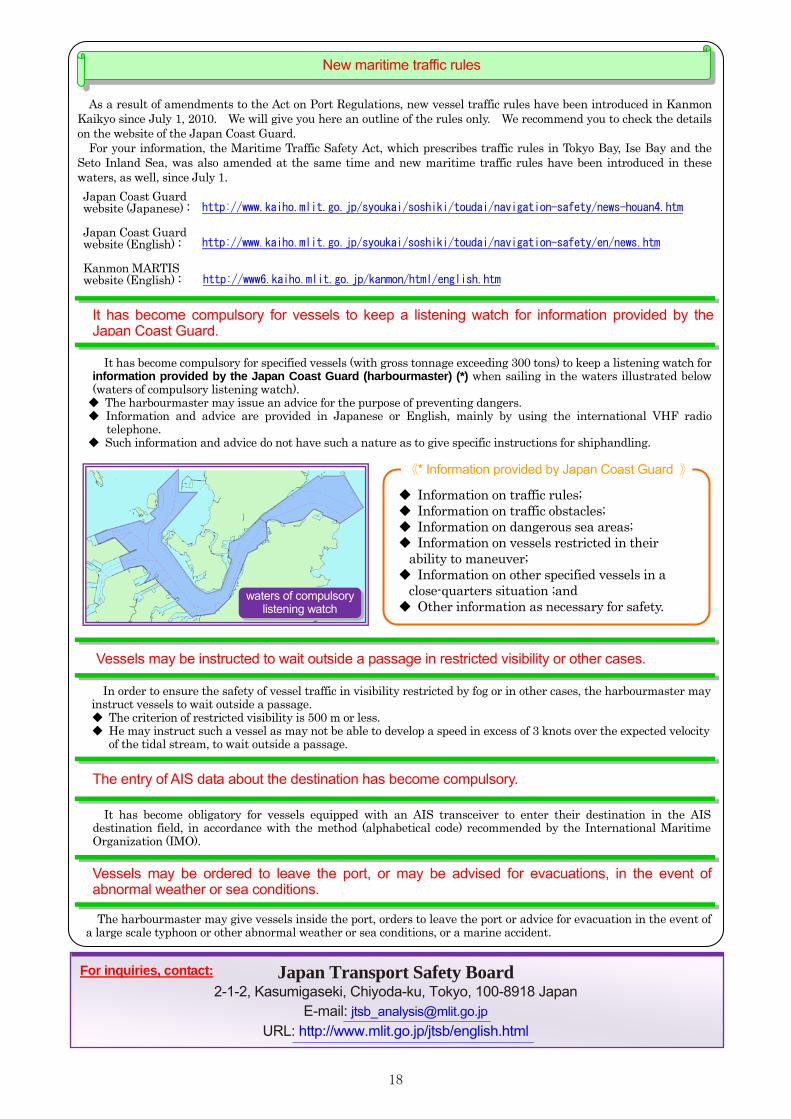
It has become compulsory for vessels to keep a listening watch for information provided by the Japan Coast Guard.
It has become compulsory for specified vessels (with gross tonnage exceeding 300 tons) to keep a listening watch for information provided by the Japan Coast Guard (harbourmaster) (*) when sailing in the waters illustrated below (waters of compulsory listening watch). ◆ The harbourmaster may issue an advice for the purpose of preventing dangers. ◆ Information and advice are provided in Japanese or English, mainly by using the international VHF radio
telephone. ◆ Such information and advice do not have such a nature as to give specific instructions for shiphandling.
waters of compulsory listening watch
Vessels may be instructed to wait outside a passage in restricted visibility or other cases.
In order to ensure the safety of vessel traffic in visibility restricted by fog or in other cases, the harbourmaster may instruct vessels to wait outside a passage. ◆ The criterion of restricted visibility is 500 m or less. ◆ He may instruct such a vessel as may not be able to develop a speed in excess of 3 knots over the expected velocity
of the tidal stream, to wait outside a passage.
The entry of AIS data about the destination has become compulsory.
It has become obligatory for vessels equipped with an AIS transceiver to enter their destination in the AIS destination field, in accordance with the method (alphabetical code) recommended by the International Maritime Organization (IMO).
Vessels may be ordered to leave the port, or may be advised for evacuations, in the event of abnormal weather or sea conditions.
The harbourmaster may give vessels inside the port, orders to leave the port or advice for evacuation in the event of a large scale typhoon or other abnormal weather or sea conditions, or a marine accident.
Japan Transport Safety Board 2-1-2, Kasumigaseki, Chiyoda-ku, Tokyo, 100-8918 Japan
E-mail: [email protected] URL: http://www.mlit.go.jp/jtsb/english.html
◆ Information on traffic rules; ◆ Information on traffic obstacles; ◆ Information on dangerous sea areas; ◆ Information on vessels restricted in their
ability to maneuver; ◆ Information on other specified vessels in a
close-quarters situation ;and ◆ Other information as necessary for safety.
《* Information provided by Japan Coast Guard 》
For inquiries, contact:
http://www.kaiho.mlit.go.jp/syoukai/soshiki/toudai/navigation-safety/news-houan4.htm
http://www6.kaiho.mlit.go.jp/kanmon/html/english.htm
http://www.kaiho.mlit.go.jp/syoukai/soshiki/toudai/navigation-safety/en/news.htm