Embed Size (px)
Citation preview
Split Rock Formation (Miocene)
and Moonstone Formation (Pliocene)
in Central Wyoming
GEOLOGICAL SURVEY BULLETIN 1121-1

Split Rock Formation (Miocene)
and Moonstone Formation (Pliocene)
in Central Wyoming
By J. D. LOVE
CONTRIBUTIONS TO GENERAL GEOLOGY
GEOLOGICAL SURVEY BULLETIN 1121-1
The new names, Split Rock formation and Moonstone formation, are intro duced for strata that partly bury Pre- cambrian knobs and peaks of the Granite Mountains
UNITED STATES GOVERNMENT PRINTING OFFICE, WASHINGTON : 1961
UNITED STATES DEPARTMENT OF THE INTERIOR
STEW ART L. UDALL, Secretary
GEOLOGICAL SURVEY
Thomas B. Nolan, Director
For sale by the Superintendent of Documents, U.S. Government Printing Office Washington 25, D.C.
CONTENTS
PageAbstract_ _____-__________-_______________-___--_--------_------- I 1Introduction._ __-________________-_______-_-_-------------_------- 2Acknowledgments, __________________________________-_--_--_-----_ 3Split Rock formation_______________________________________________ 5
Name and definition___________________________________________ 5Distribution and thickness.___________________-_____-_-___-----_ 3Lithology..__-_____-_-_____-_-.____-___--_---___-_---_-_------ 9
Lower porous sandstone sequence___________-_------__------- 9Clayey sandstone sequence. ________________________________ 13Silty sandstone sequence.__________________________________ 13Upper porous sandstone sequence_________-_-__--_-____-_--_- 14
Analytical data_________-____-________________-___----_-------- 22Stratigraphic and structural relations____________________________ 22Age and correlation,___________________________________________ 24
Moonstone formation______________________________________________ 25Name and definition____ ___________________-_____________-----_ 25Distribution and thickness,-_______________________----_-_------ 29Lithology. ____________________________________________________ 30Analytical data________________________________________________ 32Stratigraphic and structural relations_______-___-___----_-_-__--_ 33Age and correlation.____________________________________________ 34
References. _______________________________________________________ 35Index-______-____-____--_-______-____-_______-_-______-___.---___ 39
ILLUSTRATIONS
Page FIGURE 1. Index map showing location of areas discussed in text___ _______ 1-2
2. Geologic map showing major areas of outcrop of the Split Rockand Moonstone formations in central Wyoming_______----_ 4
3. Map showing localities discussed in text. ___________________ 64. Electric-log characteristics of Split Rockformation_________. __ 105. Type localities of the Split Rock and Moonstone formations. _ _ _ 166. Significant lithologies in type section of the Moonstone for
mation ______________________________________________ 31
TABLES
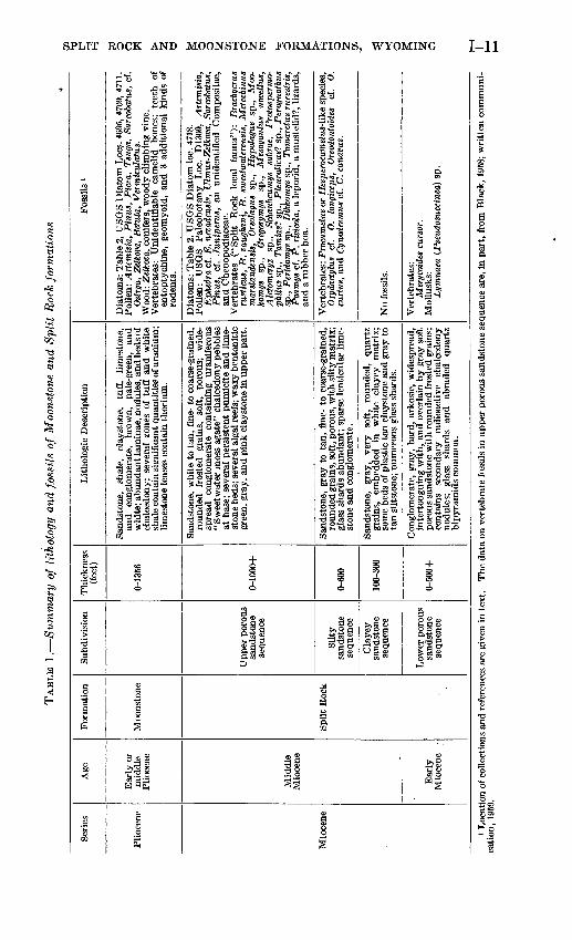
Page TABLE 1. Summary of lithology and fossils of the Moonstone and Split
Rock formations. _______________________________________ I 112. Diatoms in the Split Rock and Moonstone formations ___.____._ 203. Rock analyses of pumicite and other tuffaceous strata of Miocene
and Pliocene ages________________________________________ 23in

CONTRIBUTIONS TO GENERAL GEOLOGY
SPLIT ROCK FORMATION (MIOCENE) AND MOONSTONE FORMATION (PLIOCENE) IN CENTRAL WYOMING
By J. D. LOVE
ABSTRACT
The Split Rock formation of Miocene age has an outcrop area of more than 1,500 square miles in central Wyoming and a maximum thickness of nearly 3,000 feet. It consists chiefly of gray poorly consolidated quartz sand stone with lesser amounts of tuff, pumicite, limestone, and claystone. Nodules of uraniferous chalcedony are present in several zones. The formation un- conformably overlies Oligocene and older rocks and has partly buried the granite core of the Granite Mountains. The volume of that part of the Split Rock formation still preserved in the area is estimated as 250 cubic miles, of which approximately 200 cubic miles is sandstone. Fossil vertebrates in the lower part are of early Miocene age and those in the middle and upper parts are of middle Miocene age.
Probably during Pliocene time the Split Rock formation and younger rocks were folded into the Split Rock syncline, which is more than 70 miles long and 30 miles wide and has a structural relief of about 3,000 feet. Both sides of the syncline are downdropped along normal faults, several of which are more than 20 miles long, that have a few hundred to more than 1,000 feet of displacement.
Several "soda lakes" occupying wind-scooped depressions in the upper part of the Split Rock formation contain deposits of Na2 SO4, Na2CO3, NaHCOa, and NaCl that are believed to have been leached from the upper part of the Split Rock formation and possibly from the Moonstone formation.
The Moonstone formation of Pliocene age has a known outcrop area of about 50 square miles. It overlies the Split Rock formation with an angular unconformity of about 2° and has a maximum known thickness of 1,356 feet. It consists of highly tuffaceous thin-bedded soft pale-green, brown, and white fine-grained quartz sandstone, claystone, and shale, much of which is appar ently of lacustrine origin; the upper 125 feet of the formation is conglomeratic. Several lenses of thorium-bearing limestone are present. Beds and nodules of uraniferous chalcedony are abundant. Some shale, claystone, and tuffaceous sandstone beds contain syngenetic uranium. The Moonstone formation has been tilted gently south-southwestward, probably by downwarping of the Split Rock syncline during Pliocene time. Diatoms indicate an early to middle Pliocene age. Sparse fragmentary nondiagnostic vertebrate fossils are present.
The abnormally high uranium content of the rocks and water of the Moon stone formation suggests that a considerable amount of the uranium in the Gas Hills area 10 miles to the north and in the Crooks Gap area 15 miles to the southwest may have been leached from the Moonstone formation before it was removed by erosion from these places.
1-1
1-2 CONTRIBUTIONS TO GENERAL GEOLOGY
INTRODUCTION
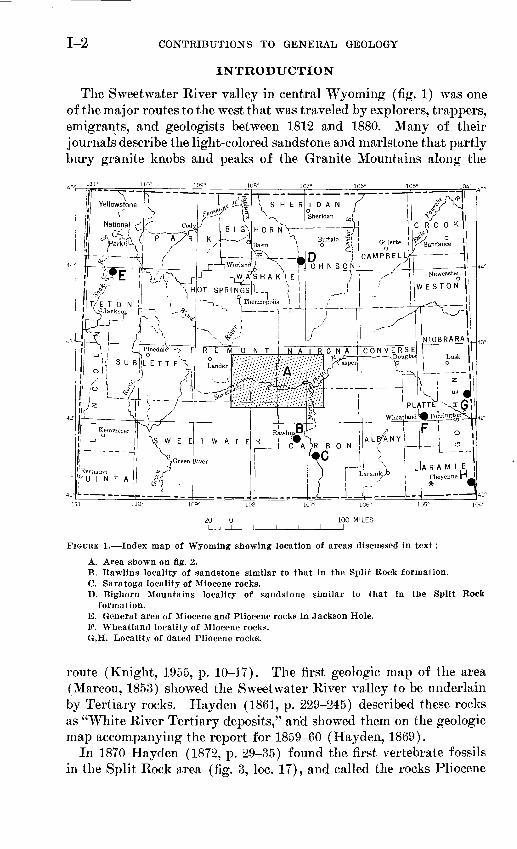
The Sweetwater River valley in central Wyoming (fig. 1) was one of the major routes to the west that was traveled by explorers, trappers, emigrants, and geologists between 1812 and 1880. Many of their journals describe the light-colored sandstone and marlstone that partly bury granite knobs and peaks of the Granite Mountains along the
FIGURE 1. Index map of Wyoming showing location of areas discussed in text:
A. Area shown on fig. 2.B. Rawlins locality of sandstone similar to that in the Split Rock formation.C. Saratoga locality of Miocene rocks.D. Bighorn Mountains locality of sandstone similar to that in the Split Rock
formation.E. General area of Miocene and Pliocene rocks in Jackson Hole. F. Wheatland locality of Miocene rocks. G,H. Locality of dated Pliocene rocks.
route (Knight, 1955, p. 10-17). The first geologic map of the area (Marcou, 1853) showed the Sweetwater River valley to be underlain by Tertiary rocks. Hayden (1861, p. 229-245) described these rocks as "White River Tertiary deposits," and showed them on the geologic map accompanying the report for 1859-60 (Hayden, 1869).
In 1870 Hayden (1872, p. 29-35) found the first vertebrate fossils in the Split Rock area (fig. 3, loc. 17), and called the rocks Pliocene
SPLIT ROCK AND MOONSTONE FORMATIONS, WYOMING 1-3
(Leidy, 1870, p. 109-110; 1873, p. 98). Endlicli (1879, p. 110-113) likewise called this sequence Pliocene, and commented:Although interesting to the paleontologist, and in some of its features to the geologist, this series nevertheless is a great aggravation. Its great horizontal extent obscures many regions of the utmost interest as regards stratigraphy, consequently a large portion of the structure of the country adjoining the Sweet- water can be established merely by insufficient data.
These sentiments have been repeated many times by geologists in subsequent years, particularly between 1945 and 1959, when oil com panies spent several million dollars on geophysical surveys along the Sweetwater Eiver valley and on 135 dry holes drilled through or into Tertiary rocks of this area.
W. C. Knight (1900, p. 229-230) described the Tertiary rocks of the Sweetwater River valley as Miocene and discussed their relation to the Granite Mountains. Granger (1910, p. 237-241) described the basal beds of Miocene age along the northwest margin of outcrop (fig. 2) and called them part of the White Eiver formation of Oligocene age. This usage was followed by Bauer (1934). Campbell and others (1925) likewise designated all the rocks along the Sweet- water River valley as White River^ialthough some Pliocene and Miocene rocks, undivided, were shown at the south end of the Wind River Mountains. The strata in the vicinity of Split Rock were called Miocene by Thorpe (1937), Love (1939, p. 112), Schultz and Falken- bach (1940), Van Houten (1950, 1954, and 1955), and Van Houten and Weitz (1956). They have been called Browns Park formation by McGrew (1951, p. 56) and Pipiringos (1955, p. 103). Both Mio cene and younger rocks were recognized by the writer in 1952, and on that basis the geologic map of Wyoming by Love and others (1955) shows Pliocene and Miocene rocks in part of the Split Rock area and Miocene rocks elsewhere along the Sweetwater River valley.
The present study is based on field and laboratory work carried on for a few days to a few weeks each year for 14 years. The work included surface mapping, measuring and sampling of many surface sections, microscope study of about 65,000 feet of drill cuttings, and examination of electric logs from 135 wells. Heavy-mineral sepa- ates, thin sections, size analyses, specific-gravity determinations, and spectrographic, rapid rock, uranium, and other analyses were made of surface and subsurface samples. Water from 24 springs and wells in this region was analyzed for uranium by the Geological Survey.
ACKNOWLEDGMENTS
This study has been made possible by the cooperation, encourage ment, assistance, criticism, and contribution of data by many people during a period of 14 years. The writer acknowledges with thanks
1-4 CONTRIBUTIONS TO GENERAL GEOLOGY
SPLIT ROCK AND MOONSTONE FORMATIONS, WYOMING
and appreciation the help of the following: D. E. Beardsley, W. G. Bell, D. L. Blackstone, Jr., Frank Byrne, N. M. Denson, C. K. Fisher, L. P. House, Mr. and Mrs. Walter Irvin, P. T. Jenkins, A. L. Lyth, P. 0. McGrew, A. Paap, E. I. Rich, P. E. Soister, A. G. Speight, J. G. Stephens, H. A. Tourtelot, F. B. Van Houten, D. W. Wiger, and H. D. Zeller.
The following Geological Survey paleontologists studied the fos sils: K. E. Lohman identified the diatoms; E. B. Leopold the pollen; E. A. Scott, the wood; G. E. Lewis, E. W. Wilson, and M. J. Hough the vertebrate fossils; and Eichard Eezak the algae. C. C. Black made available the list of fossil vertebrates he had identified from the Split Eock formation.
E. S. Houston studied the thin sections and heavy mineral separates. E. F. Gantnier made mechanical analyses, specific-gravity determina tions, and prepared heavy-mineral separates. Analytical data were obtained through cooperation of L. B. Eiley, L. F. Eader, and W. W. Niles. J. N. Eosholt made extensive studies of thorium and asso ciated elements in the Moonstone formation.
The cooperation of Dr. S. H. Knight, chairman of the Geology De partment, University of Wyoming, and Dr. H. D. Thomas, State geologist, through the years of this study has been of inestimable value. The writer is indebted to D. L. Healey for opportunity to see an unpublished geophysical study of the Crooks Gap area and to J. G. Stephens, E. I. Eich, and F. B. Van Houten for permission to see manuscripts in preparation for publication.
Between 1951 and 1955 the portion of the investigation that was related to uranium was done on behalf of the Division of Eaw Mate rials of the U.S. Atomic Energy Commission.
SPLIT ROCK FORMATION
NAME AND DEFINITION
A new name, Split Eock formation, is here used for a thick and wide spread succession of light-gray to tan poorly cemented quartz sand stone with lesser amounts of conglomerate, claystone, limestone, tuff, and pumicite of Miocene age that unconformably overlies Oligocene and older rocks and is unconformably overlain by Pliocene rocks. The formation derives its name from Split Eock (fig. 2; sec. 18, T. 29 N., E. 89 W., Natrona County, Wyo.), a cloven granite peak in the Gran ite Mountains. This peak is in the central part of the outcrop area and has been a well-known landmark from the time the first explorers entered the region.
The new name is assigned to these rocks after consideration of the applicability of existing names used in adjacent regions. Difficulty
594240 O 61 2
1-6 CONTRIBUTIONS TO GENERAL GEOLOGY
\l
\in
r/
I
SPLIT ROCK AND MOONSTONE FORMATIONS, WYOMING 1-7
1-8 CONTRIBUTIONS TO GENERAL GEOLOGY
has been found in correlating fossiliferous Miocene rocks in eastern Wyoming (fig. 1, loc. F) with named formations and groups in Nebraska (L. W. McGrew, oral communication, 1960). Therefore, it is inadvisable to extend the Nebraska terminology 75 to 100 miles still farther west into central Wyoming.
The name Browns Park has been applied to strata of Miocene age in the Split Eock area by McGrew (1951, p. 56) and Pipiringos (1955, p. 103). McGrew (1951, p. 56) and Carey (1955, p. 47-49) reviewed the problem of the age of the type Browns Park formation in north eastern Utah and northwestern Colorado, 130 miles southwest of Split Eock. McGrew concluded that the vertebrate fossils presum ably from the Browns Park formation at Maybell, Colo., 50 miles southeast of the type area, are of middle Miocene age and similar to those in the upper part of the Split Eock formation. However, it is not known how much, if any, of the several thousand feet of strata comprising the type Browns Park formation is of middle Miocene age. Detailed descriptions of the stratigraphy and lithologic characteris tics of the Browns Park formation have not been published, and with out these data no close comparison can be made with the Split Eock formation. No rocks have been dated as Miocene in the area between Browns Park and central Wyoming.
Approximately 85 miles south-southeast of Split Eock, in the Sara toga area (fig. 1, loc. C), both middle and upper Miocene rocks are known (McGrew, 1951, p. 54-57; 1953, p. 61-64; Montagne, 1954, p. 1384). These rocks correlate with part of the Browns Park forma tion of the Maybell area, of northwestern Colorado, with part of the North Park formation of central-northern Colorado (Montagne and Barnes, 1957, p. 55-60), and with at least the upper part of the Split Eock formation in central Wyoming.
No single complete section typical of the Split Eock formation as a whole is exposed. This is because the formation has gentle dips and the strata readily weather to a rolling surface of low relief. The de scription that follows is based on more than 20 surface sections sup plemented by studies of electric logs, radioactivity logs, and cuttings from drill holes. Two surface sections, both at well-known fossil localities, are presented. The most abundant fossils and greatest den sity of subsurface information are in the area southeast, south, and southwest of Split Eock (fig. 2; fig. 3, Iocs. 14-17 and 20).
DISTRIBUTION AND THICKNESS
The Split Eock formation crops out in an area of more than 1,500 square miles in central Wyoming (fig. 2). Erosion remnants are present for an additional 50 miles to the east, as far as the northern

SPLIT ROCK AND MOONSTONE FORMATIONS, WYOMING 1-9
part of Albany County, Wyo. (fig. 1). A remnant is also present in a syncline south of the Continental fault system (fig. 2). Similar rocks are known within and adjacent to the town of Rawlins, 40 miles south of Split Eock (fig. 1, loc. B); on the crest of the Bighorn Mountains, 120 miles north of Split Rock (fig. 1, loc. D); and in part of the Colter formation in Jackson Hole, 180 miles northwest of Split Rock (fig. 1, loc. E).
The thickest known subsurface section of the Split Rock forma tion is 2,732 feet, in the Sinclair Oil and Gas Co., Arkansas Creek No. 1 dry hole in the NW^NW^NE^ sec. 4, T. 27 N., R. 86 W., Car bon County, Wyo. (fig. 3, loc. 10). Eleven other wells have penetrated more than 1,500 feet of the formation. It is probable that in the southeastern part of the area shown on figure 2 the thickness exceeds 3,000 feet. Inasmuch as Pliocene rocks overlie the Split Rock forma tion in a relatively small area (50 square miles), and elsewhere the upper part of the formation has been eroded away, there is no way of determining the original maximum thickness and volume of Miocene sedimentary rocks. A rough computation, based on surface, subsur face, and geophysical studies, indicates that the volume of Miocene rocks still present within the area of figure 2 is more than 250 cubic miles, of which perhaps 200 cubic miles is sandstone.
LITHOLOGY
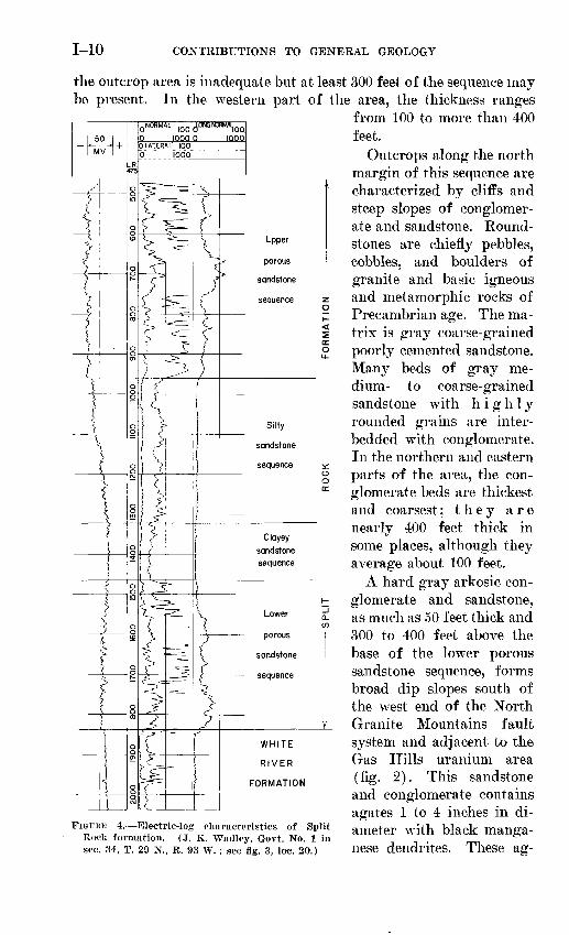
The Split Rock formation can be subdivided into four lithologic sequences (fig. 4) in the central and western parts of the area shown on figure 2, where drill cuttings, electric logs, and radioactivity logs are relatively numerous. These sequences are, from oldest to youngest, a lower porous sandstone, a clayey sandstone, a silty sandstone, and an upper porous sandstone as summarized in table 1. Figure 4 shows their electric-log characteristics. More detailed study will be neces sary to determine the areal extent of these sequences.
LOWER POROUS SANDSTONE SKQTJENCE
The lower porous sandstone sequence is the coarsest grained and most widespread of the four subdivisions. Rocks described by Van Houten (1954) as Miocene (?) and by Van Houten and Weitz (1956) as Miocene, are part of this sequence, as are the Miocene rocks described by E. I. Rich (written communication, 1959) along the southeast margin of the Wind River Basin (fig. 2; fig. 3, loc. 3).
The lower porous sandstone sequence ranges in thickness from about 500 feet near the north margin of outcrop (fig. 2) to a featheredge in the south-central part, Much of the change in thickness is the result of deposition on a surface of high relief cut in Precambrian rocks of the Granite Mountains. Subsurface control in the southeast part of
1-10 CONTRIBUTIONS TO GENERAL GEOLOGY
the outcrop area is inadequate but at least 300 feet of the sequence may be present. In the western part of the area, the thickness ranges
from 100 to more than 400 feet.
Outcrops along the north margin of this sequence are characterized by cliffs and steep slopes of conglomer ate and sandstone. Round- stones are chiefly pebbles, cobbles, and boulders of granite and basic igneous and metamorphic rocks of Precambrian age. The ma trix is gray coarse-grained poorly cemented sandstone. Many beds of gray me dium- to coarse-grained sandstone with highly rounded grains are inter- bedded with conglomerate. In the northern and eastern parts of the area, the con glomerate beds are thickest and coarsest; they are nearly 400 feet thick in some places, although they average about 100 feet.
A hard gray arkosic con glomerate and sandstone, as much as 50 feet thick and 300 to 400 feet above the base of the lower porous sandstone sequence, forms broad dip slopes south of the west end of the North Granite Mountains fault system and adjacent to the Gas Hills uranium area (fig. 2). This sandstone and conglomerate contains agates 1 to 4 inches in di ameter with black manga nese dendrites. These ag-
FORMATION
FIGURE 4. Electric-log characteristics of Split Rock formation. (J. K. Waclley, Govt. No. 1 in sec. 34, T. 29 N., R. 93 W. ; see fig. 3, loc. 20.)
SPLIT ROCK AND MOONSTONE FORMATIONS, WYOMING 1-11
. a, s.1*f K, w.a 13 s^'g'S'S
^111-a .s u B_ li'^ 8l ^|l"
Si-srfllco £ ^ & § a^|l| ^.Ss-S-g 6"5-s I N-t5 » §S5| £E^^SIS-S
II1!! 11
go
ille g e|°l
g.w%;11^
fe'l« I3 1l°'l
|:fS~ d S »>a Sti .!- e S
111£_ CV 3 S^ «
Vertebrates: Merycoides
Mollusks:
Lymnaea (
ogi
sfg'ssa g S.g3|f * !* S
rt -a « S S-rt'O S
in 05 5 C^^ fee * o
siOi iif-Ull1 nis,X5.SNg*
« firt o'S^aisss lllili*lls!!Hill!
S.S.2
yst
i Kis ° "®^^*l ss1||- C rfl -4^ C9 OifiH-t-aS^llgt sHe-gil s s"!1 ^ > ^. -^'*-' S "c§ ^" ^ £?
S K Mrt ^
-grained, y matrix; lar lime-
oj~ aOC 4>3'1«
ia§e o a <a £ m .Sir*
I||| B8||^ sl6b|3 8
ill SljSg t- 6X1 to
S M S
SSg?P CQ C9*§& d^l .
PllI"!l sisf-S-s-a ^33fe 51l >rgia.'OS 3
>>ro art08 S,~.-a!ll
II111!g.S a§ rt* O
§ pS S
11111
1-12 CONTRIBUTIONS TO GENERAL GEOLOGY
ates are radioactive, fluoresce brilliant yellow, and many contain an unidentified yellow uranium mineral. They were formed in cavities after the conglomerate was deposited but apparently before deposition of the youngest sequence in the Split Rock formation. The origin of these agates and their contained uranium are discussed further in connection with the youngest sequence.
Intertonguing with, and overlying, the conglomeratic part, of the lower porous sandstone sequence, is massive to thick-bedded or cross- bedded gray medium- to coarse-grained sandstone. This sandstone is characterized by abundant colorless frosted rounded coarse quartz grains, some with a red hematite coating, and abundant tiny (about 0.1 mm) round black magnetite grains similar to those described by Skolnick (1959) as "Miocene meteoric dust." Rounded well-sorted red hematite-coated quartz grains (0.25 to 0.5 mm) are so abundant in some wells in the western part of the area shown on figure 2 that the sandstone is dull pink. In these localities the sandstone has little fine-grained matrix or cementing material and resembles dune sand.
Glass shards, rounded grains of several varieties of pyroxene, angu lar grains of unaltered plagioclase, and slightly abraded quartz bi- pyramids are common and in places abundant in both the sandstone and conglomerate. Pumicite beds are present but not common in this sequence (Stokes and Varnes, 1955, p. 116, defined pumicite as a pum ice that "has been blown to bits by the force of volcanic explosion so that the cells are broken"). Thin limestone beds are fairly common near the northern margin of the area of outcrop and are comparatively rare elsewhere. Van Houten (1954) reports that the sandstone con tains abundant grains of magnetite and augite and moderate amounts of hypersthene and green-brown hornblende. Sandstone in the under lying White River formation of Oligocene age contains abundant green-brown hornblende and lesser amounts of magnetite, augite, and hypersthene.
The lower porous sandstone sequence has yielded one vertebrate fossil, a complete skull of Merycoides cursor (table 1), which was found by E. I. Rich in the SW^4 sec. 12, T. 31 N., R. 85 W. (fig. 3, loc. 3), approximately 400 feet above the base of the Split Rock for mation. G. E. Lewis, who identified the fossil, considers it to be of early Miocene age, representing rocks equivalent in age to the Gering sandstone of the Arikaree group of Nebraska.
Van Houten (written communication, 1959) found fossil gastro pods (identified by D. W. Taylor) of the genus Lymnaea (Pseudosuc- cinea) sp. (table 1) in a silicified sandstone and limestone zone between 100 and 150 feet above the base of the Split Rock formation near the northwest margin of the area.
SPLIT ROCK AND MOONSTONE FORMATIONS, WYOMING 1-13
CLAYEY SANDSTONE SEQUENCE
The clayey sandstone sequence is 100 to 300 feet thick, very soft, consists almost entirely of clayey gray sandstone, and is readily rec ognizable in most electric logs (fig. 4). It is not as easy to distinguish from overlying and underlying sandstone units in drill cuttings be cause the clay washes out and only sandstone remains. The sand stone is fine to medium grained and contains many frosted rounded quartz grains, hematite-coated quartz, and some slightly abraded quartz bipyramids. Gray to tan siltstone is common, and glass shards are numerous in all rock types.
The eastern extent of the clayey sandstone sequence has not been determined. Bentonitic gray and pink claystone beds are present near the northeast margin of the area of outcrop about 300 feet above the base of the Split Eock formation (fig. 3, loc. 2). They overlie the conglomerate and sandstone of the lower porous sandstone sequence. These claystone beds apparently occupy the stratigraphic position of the clayey sandstone sequence and may be a lateral equivalent.
The.contact between the clayey sandstone and underlying lower porous sandstone sequence is at the lithologic change from coarse grained conglomeratic sandstone below to silty and clayey fine-grained sandstone above. In the south-central part of the area, where the underlying lower porous sandstone sequence wedges out against Pre- cambrian granite knobs or against topographic highs in pre-Miocene formations, the clayey sandstone sequence is the basal unit of the Split Rock formation.
No fossils have been found in the clayey sandstone sequence. The sequence is underlain by lower Miocene rocks and overlain by middle Miocene rocks.
SILTY SANDSTONE SEQUENCE
The silty sandstone sequence consists of fine- to coarse-grained light-gray sandstone which is sparsely pebbly in some areas. Tuffa- ceous beds are present, and glass shards are abundant in all rock types. Tiny (0.1 mm) rounded black magnetite grains, frosted rounded colorless quartz grains, and red hematite-coated quartz grains (0.25 to 0.5 mm) are abundant. Limestone is sparse.
This sequence is present in all the thicker subsurface sections in the southern and southwestern parts of the area shown in figure 2, but its extent in the northern and eastern parts of the area is not known. It is commonly 300 to 600 feet thick in the southern and western parts where it has not been truncated by post-Miocene erosion.
The base of the sequence is rather indefinite and probably grada- tional. There is a gross lithologic change, however, from clayey sandstone below to silty, and in many places pebbly, sandstone above.
594240 O 61 3
1-14 CONTRIBUTIONS TO GENERAL GEOLOGY
J. G. Stephens (written communication, 1959) found in the sec. 10, T. 29 N., R. 93 W. (fig. 3, loc. 21; table 1), in the silty sand stone sequence, the snout of a camel identified by G. E. Lewis as P-ro- camelus or a Hesperocam^his-like species of middle Miocene or younger age. Rachou 1 found Oxydactylus cf. 0. longiceps in the SW14NE14 sec. 4, T. 31 N., R. 87 W. (fig. 3, loc. 5; table 1), and Oreodontoides cf. 0. curtus and Cynodesmus cf. C. canavus in the SE14NE1/4 sec. 10, T. 31 N., R. 87 W. (fig. 3, loc. 6; table 1). These fossils were collected from buff to white fine-grained sandstone inter- bedded with tuff and pumicite that may be part of the silty sandstone sequence. The fossils are considered to be of early middle Miocene age.
UPPER POROUS SANDSTONE SEQUENCE
The upper porous sandstone sequence (table 1) is the thickest of the subdivisions, being as much as 1,000 feet thick in the western part of the area shown on figure 2 and, if tentative correlations are correct, 1,700 feet thick.in the southeastern part. This sequence forms most of the outcrops in the deepest part of the post-Miocene Split Rock syncline between the Sweetwater River and the South Granite Mountains fault system (fig. 2).
A conglomerate and sandstone unit less than 100 feet thick, which is considered to be the basal bed of the upper porous sandstone se quence, forms broad dip slopes in the north-central part of the out crop area of the Split Rock formation. No subsurface sections are available here, but data from isopach maps suggest that the conglom erate is about 900 feet above the base of the formation. This con glomerate contains the "SwTeetwater moss agates" that were described by Endlich (1879, p. 113). These agates are subrounded, frosted, and commonly less than 1 inch in diameter. They were apparently shaped by streams and wind before deposition as pebbles in the con glomerate. Most are translucent gray with black manganese den- drites, but some are red or brown. They are moderately radioactive (those analyzed contain about 0.01 percent uranium) and many fluoresce a brilliant yellow. In spite of having been collected by lapidaries for the last 100 years, they are still abundant.
These agates, aside from being extensively abraded, are identical to those previously described in the lower porous sandstone sequence. If the older sequence was the source of the agates, the lower part of the Split Rock formation was eroded somewhere to the north or northwest of the area shown on figure 2. Further, the uranium and silica were probably emplaced in the lowTer porous sandstone sequence during some part of early or middle Miocene time; sub-
1 Rachou, J. F., 1951, Tertiary stratigraphy of the Rattlesnake Hills, central Wyoming: Wyoming Univ. M.A. thesis, on open file.
SPLIT ROCK AND MOONSTONE FORMATIONS, WYOMING 1-15
sequently, the agates were exposed, transported, abraded, and then redeposited in the upper porous sandstone sequence. The abundance of agates requires a prolific source, and no other is known.
Medium- to coarse-grained, gray to buff, massive to coarsely cross- bedded sandtone is the dominant lithology in the upper porous sand stone sequence (fig. 5A). The sandstone beds resemble most of those in the underlying part of the Split Rock formation in that they contain abundant rounded frosted gray quartz grains, red hematite- stained quartzt grains, and abundant tiny (0.1 mm) black round mag netite grains. Limestone beds, some of which persist for several miles, are common. Algal reefs, in places 10 to 20 feet thick, are present at several localities. Green to white soft waxy claystone is common in the upper part of the sequence. In the southeastern part of the area one bentonitic white tuffaceous claystone sequence is nearly 300 feet thick. More detailed study may indicate that this is a separate sequence younger than the upper porous sandstone.
Remarkably pure bluish-white pumicite beds are present in the upper porous sandstone sequence (see unit 20 of section at "Devils Gate fossil locality" and table 3). The glass shards, which are the major constituent, are curved or rectangular; some are pink and others are colorless. Sandstone beds in this sequence contain plagi- oclase (predominantly calcic andesine and sodic labradorite), san- idine, red-brown hornblende, red-brown biotite, and monoclinic pyroxenes.
Sieve analyses of 17 random sandstone samples show that 75 per cent of the sandstone is in the size range 0.050 to 0.35 mm and is distributed as shown below. Specific gravity of the sandstone averages 1.90.
Size range, in mm Percent0.050-0. 062 ______________________________ 6.20. 062-0. 088 ______________________________ 10. 70. 088-0.125 ______________________________ 20. 70.125-0.175 ______________________________ 18.30.175-0. 25 ______________________________ 9.30.25 -0.35 ______________________________ 9.9
The base of the upper porous sandstone sequence is moderately well defined at most places in drill cuttings, electric logs (fig. 4), and outcrops. The contact is marked by a change from gray silty sandstone below to coarser grained, more porous, conglomeratic, and more limy sandstone above. This change may mark an erosional un conformity if the interpretation regarding the source of uraniferous agates is correct. The top of the upper porous sandstone sequence is the present erosion surface except where the sequence is over lapped by Pliocene rocks in the central part of the area and, perhaps, by a clayey sequence of uncertain correlation in the southeastern part.

1-16 CONTRIBUTIONS TO GENERAL GEOLOGY
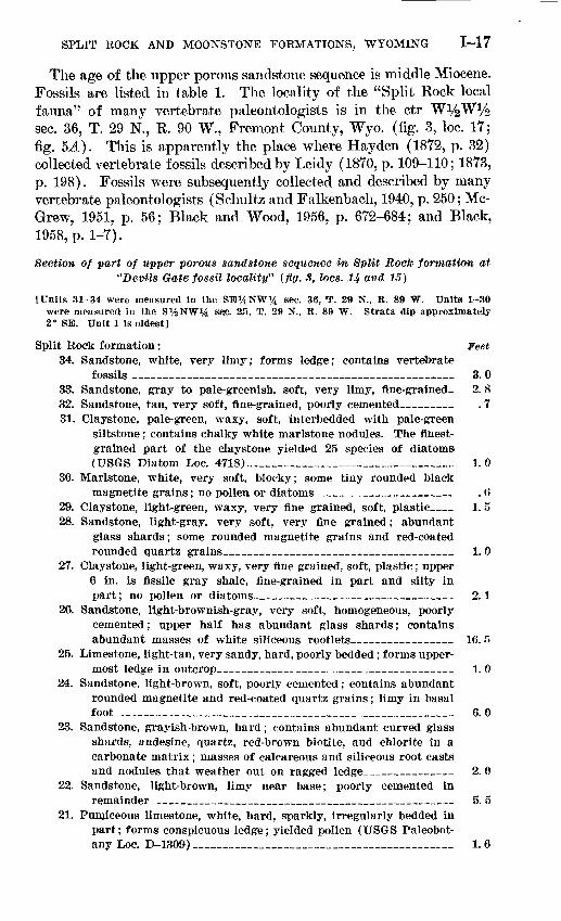
FIGURE 5. Type localities of Split Rock and Moonstone formations. A. Section of part of upper porous sandstone sequence in Split Rock formation at site of "Split Rock local fauna" (fig. 3, loc. 17, SW%SW%NW% sec. 36, T. 29 N., R. 9O W.). Arrow indicates man for scale. B. Air oblique photo looking west along White Ridge (fig. 3, loc. 12, S% sec. 17, T. 30 N., R. 89 W.), where type section of Moonstone formation through unit 31 is exposed as light-colored outcrops. Precambrian granite knobs of partly exhumed Granite Mountains are in distance and at lower right.
SPLIT ROCK AND MOONSTONE FORMATIONS, WYOMING 1-17
The age of the upper porous sandstone sequence is middle Miocene. Fossils are listed in table 1. The locality of the "Split Rock local fauna" of many vertebrate paleontologists is in the ctr W^W^ sec. 36, T. 29 N., R. 90 W., Fremont County, Wyo. (fig. 3, loc. 17; fig. 5JL). This is apparently the place where Hay den (1872, p. 32) collected vertebrate fossils described by Leidy (1870, p. 109-110; 1873, p. 198). Fossils were subsequently collected and described by many vertebrate paleontologists (Schultz and Falkenbach, 1940, p. 250; Mc- Grew, 1951, p. 56; Black and Wood, 1956, p. 672-684; and Black, 1958, p. 1-7).
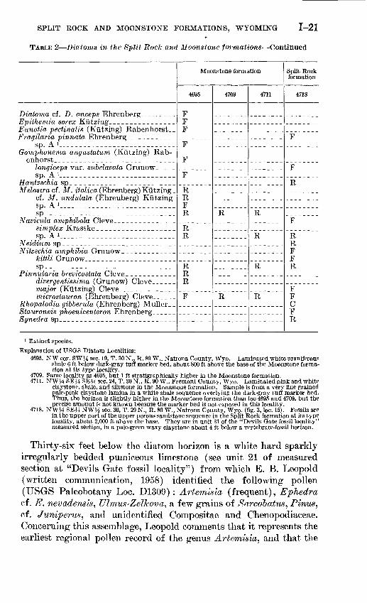
Section of part of upper porous sandstone sequence in Split Rock formation at "Devils Gate fossil locality" (fig. 3, Iocs. 14 and 15)
[Units 31-34 were measured In the SB%NW% sec. 36, T. 29 N., R. 89 W. Units 1-30 were measured in the S%NW*4 &e;c. 2.5, T. 29 N., R. 89 W. Strata dip approximately 2° SE. Unit 1, Is oldest]
Split Rock formation: Feet34. Sandstone, white, very limy; forms ledge; contains vertebrate
fossils ________________________________ _- 3. 033. Sandstone, gray to pale-greenish, soft, very limy, fine-grained. 2.832. Sandstone, tan, very soft, fine-grained, poorly cemented_ _ . 731. Claystone, pale-green, waxy, soft, interbedded with pale-green
siltstone; contains chalky white marlstone nodules. The finest- grained part of the claystone yielded 25 species of diatoms (USGS Diatom Loc. 4718)_______________________ 1.0
30. Marlstone, white, very soft, blocky; some tiny rounded blackmagnetite grains ; no pollen or diatoms___________ _ . 6
29. Claystone, light-green, waxy, very fine grained, soft, plastic__ 1. 528. Sandstone, light-gray, very soft, very fine grained; abundant
glass shards; some rounded magnetite grains and red-coated rounded quartz grains________________________ 1. 0
27. Claystone, light-green, waxy, very fine grained, soft, plastic ; upper 6 in. is fissile gray shale, fine-grained in part and silty in part; no pollen or diatoms______________________ 2.1
26. Sandstone, light-brownish-gray, very soft, homogeneous, poorly cemented; upper half has abundant glass shards; contains abundant masses of white siliceous rootlets___________ 16. 5
25. Limestone, light-tan, very sandy, hard, poorly bedded; forms upper most ledge in outcrop__________________________ 1. 0
24. Sandstone, light-brown, soft, poorly cemented; contains abundant rounded magnetite and red-coated quartz grains; limy in basal foot _____________________________________ 6. 0
23. Sandstone, grayish-brown, hard; contains abundant curved glass shards, andesine, quartz, red-brown biotite, and chlorite in a carbonate matrix; masses of calcareous and siliceous root casts and nodules that weather out on ragged ledge__________ 2. 0
22. Sandstone, light-brown, limy near base; poorly cemented inremainder _________________________________ 5. 5
21. Pumiceous limestone, white, hard, sparkly, irregularly bedded in part; forms conspicuous ledge; yielded pollen (USGS Paleobot- any Loc. D-1309) _____________________________ 1.6

1-18 CONTRIBUTIONS TO GENERAL GEOLOGY
Section of part of upper porous sandstone sequence in Split Rook formation at "Devils Gate fossil locality" (fig. 3, Iocs. 14 and 15) Continued
Split Rock formation Continued Feet20. Pumicite, white, pure, homogeneous, bedded ; rock analysis is given
in tableS (lab. No. 143218)______________________ 10.019. Sandstone, light-brown, soft, poorly cemented except near base
where it is limy, homogeneous____________________ 4. 518. Limestone, white, nodular; forms weak ledge above a conspicuous
one; contains abundant coarse and fine sand grains________ 1. 017. Sandstone and limestone, light-gray, soft, nodular; forms slope
above conspicuous ledge_______________________ 2. 016. Limestone, gray, hard; weathers to ragged conspicuous ledge, the
middle one of three on slope; masses of siliceous rootlets in lower part; very sandy in part; no pollen or diatoms. __ 4. 0
15. Sandstone, light-gray to tan, soft, poorly cemented in part, very limy in part; abundant tiny rounded black magnetite and larger rounded red-coated quartz grains_________________ 11. 0
14. Limestone, white, sandy in part, moderately pure in middle, soft,nodular _________________________________ 4. 0
13. Sandstone, brown, very limy near base and top, poorly cementedin middle__________________________________ 2. 0
12. Limestone, white, hard, nodular; forms lowest conspicuous raggedledge in exposure; no pollen or diatoms________ _ 3. 5
11. Limestone, white, nodular, sandy; contains glass shards; forms ledge in westernmost spurs and disappears into slope in main outcrop _________________________________ 3.0
10. Sandstone, light-brown, very soft, homogeneous; abundant tinyrounded magnetite and larger rounded red-coated quartz grains. 13. 0
9. Variable sequence; lower half is soft blocky white sandy limy tuff(?), becoming more sandy upward, and grading up to fine grained soft sandstone at top________________ 6. 0
8. Sandstone, white, siliceous, impregnated with green silica; formsconspicuous ledge that caps westernmost spur of outcrop 2. 0
7. Sandstone, white, nodular, with rounded nodules; some vertical root( ?) fillings as much as 2 ft long and 3 in. wide; more evenly bedded in upper part; forms lowest cliff in westernmost exposure______________________________-__- 14. 0
6. Pumiceous sandstone, white, moderately thin-bedded_ 4. 05. Sandstone, brown, soft; abundant tiny black rounded magnetite
grains and larger rounded red-coated quartz grains 7. 04. Siltstone, light-gray, soft, clayey in lower part, sandy in upper;
contains glass shards; gradational with underlying unit 3. 03. Claystone, pale-green, waxy, fine-grained, plastic, finely blocky;
slightly sandy in part; no pollen or diatoms_ 2.02. Tuff, chalky-white, fine-grained, calcareous, blocky, sandy; abund
ant glass shards___________________ ___ 2. 51. Sandstone, grayish-brown, soft, massive, except for sparse weak
ledges in middle; slightly calcareous; forms slope at base of good exposures____________________ - 23. 0
Total thickness__________________________ 166. 8

SPLIT ROCK AND MOONSTONE FORMATIONS, WYOMING 1-19
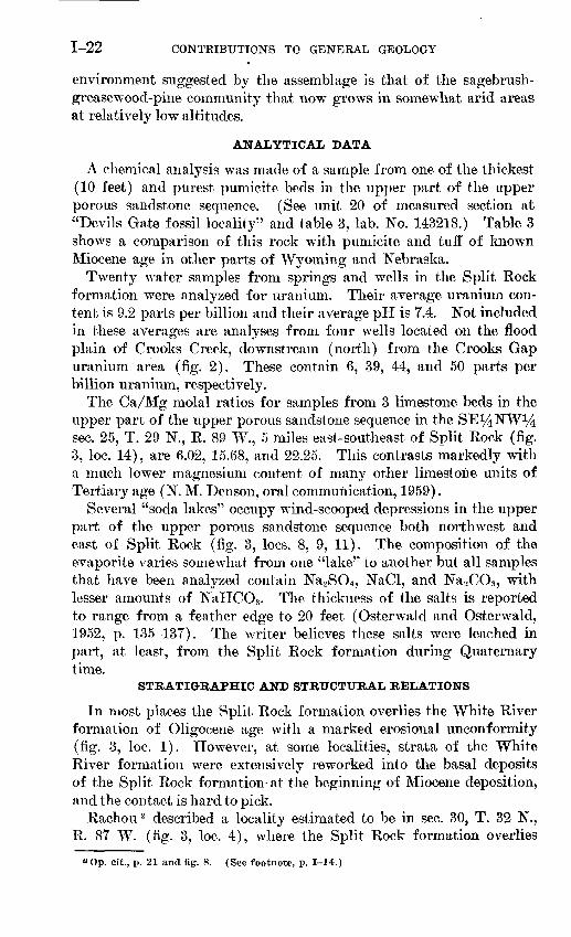
Section of part of upper porous sandstone sequence in Split Rook formation at site of "Split Rock local fauna" (flg. 3, loc. 11; fig. 5A)
[Section wag measured on west face of conspicuous bare sandstone .outcrop in the' SW%SW%NW% sec. 36, T. 29 N., R. 90 W., Fremont County. Strata strike N. 80° E., dip 4° S. Unit 1 is oldest]
Split Rock formation: Feet5. Sandstone, tan, soft, fine-grained, porous; abundant tiny rounded
black magnetite grains and larger rounded red-coated quartz grains; forms upper massive cliff; basal 5 ft weathers to honey combed ragged ledge because of introduction of irregular masses of secondary calcite; contains plagioclase, red-brown biotite, zir con, sanidine, augite, amphibole, and rectangular pink glass shards; upper zone of "Split Rock local fauna" of vertebrate paleontologists ____________-_ -___ 49
4. Sandstone, tan, fine-grained, porous; abundant tiny rounded black magnetite grains and larger rounded red-coated quartz grains; so soft that it forms a slope between cliffs; not lithologically dis tinct from overlying and underlying units except for degree of cementation ________________________ _ 22
3. Sandstone, tan, soft, fine-grained, porous, massive; abundant tiny rounded magnetite grains and larger rounded red-coated quartz grains; forms lower cliff; middle zone of "Split Rock local fauna" of vertebrate paleontologists_______-___ '65
2. Tuff, snowy-white, light-weight, moderately hard, noncalcareous, massive; cut by vertical smooth-sided tubes about 1 in. in dia meter filled with tan sandstone; forms conspicuous marker bed in lower part of exposure; thin section shows rock to be a vitric and crystal tuff in which are a variety of colorless glass shards of many shapes such as crescents, stars, wishbones, and bubbles; minerals include plagioclase, green-brown biotite, sanidine(?), microcline, and quartz __________________________ 1
1. Sandstone, tan, soft, fine-grained, porous, massive; abundant tiny rounded black magnetite grains; thin section shows pink sub- rounded glass shards, plagioclase, green amphibole, pyroxene, quartz, sanidine, red-brown biotite, magnetite, and microcline. Rock fragments include vitrophyre, porphyry, quartzite, and possibly basalt ____________ _____ 17
Total thickness __________________________ 154
The writer collected teeth identified by M. J. Hough (written com munication, 1953) as Poamys cf. P. rivicola from an anthill at the base of exposures in the SW%NW^4NE^4 sec. 31, T. 29 N., R. 89 W., about 2 miles due south of Split Rock (fig. 3, loc. 16).
Schultz and Falkenbach (1940, p. 250) described another verte brate-fossil locality "about 11 miles west of Devil's Gate, Natrona County, Wyoming." The fossils occur in a limy sandstone in the SE14NW14 sec. 36, T. 29 N., R. 89 W. (See unit 34 of measured sec tion at "Devils Gate fossil locality".) This bed is believed to be at least 200 feet stratigraphically higher than beds containing the "Split
1-20 CONTRIBUTIONS TO GENERAL GEOLOGY
Rock local fauna." Sclmltz and Falkenbach (1940, p. 250) obtained Brachycrus vaughani and B. sioeetwaterensis from the Devils Gate locality.
A pale-green waxy claystoiie 3.5 feet below the vertebrate-bearing sandstone just described (measured section, unit 31) yielded 25 species of diatoms (USGS Diatom Loc. 4718, table 2). Concerning this diatom assemblage, K. E. Lohman states (written communication, 1959) :
The Split Rock diatom assemblage contains only one extinct species, Navicula sp. A which has a known geologic range of late middle Miocene to middle Plio cene. All of the others are still represented in living assemblages elsewhere; however, nearly half have known geologic ranges from middle Miocene to Re cent. Finding them in these middle Miocene rocks means that the geologic ranges of all of them should be extended to middle Miocene time, but gives no independent check on the age of this formation.
The diatoms are dominantly fresh-water forms with a few that also live in saline lakes and marshes. No pelagic species are present, suggesting shallow lacustrine or flood-plain conditions during deposition. The most abundant spe cies present, Rhopalodia gibberula, frequently, but not always, now lives in hot springs which at least hints at the possibility of hot spring activity somewhere in the basin of deposition or in streams contributing water to it. The case for hot spring activity would have been strengthened by finding species more definitely preferring such habitat.
TABLE 2. Diatoms in the Split I^ock and Moonstone formations
[Identified by K. E. Lohman. Explanation: R, rare; P, frequent; C, common. All the listed diatoms are rare when compared with samples of average diatomaceous rocks; therefore, the classification is relative only to abundance of diatoms in these 4 samples.]
Achnanthes lanceolata (Brebisson) Grunow_ Amphora cf. A. ovalis Kiitzing
salina Wm. Smith. ___Anomoeoneis cf. A. polygramma (Ehren-
berg) Cleve _ _ __cf. A. sculpta Ehrenberg _ _sphaerophora (Kiitzing) Pfitzersphaerophora var. biceps Ehrenbergsphareophora var. guntheri Mullersp. A !spp ______________________________
Caloneis bacillum (Grunow) Mereschkow- sky
formosa (Gregory) Clevecf. C. schumanniana (Grunow) Cleve. sp
Cymatopleura elliptica (Brebisson) Wm. Smith _
Cymbella cf. C. austriaca Grunowhauckii Van Heurckmexicana (Ehrenberg) Cleve.._
Moonstone formation
4695
R
C
F
F F
R
4709
F
R
R
4711
F
R R
R
F
See footnotes at end of table.
Split Rock formation
4718
R R
R
R
F
R F R
F
FF
SPLIT HOCK AND MOONSTONE FORMATIONS, WYOMING 1-21
TABLE 2 Diatoms in the Split Rock and Moonstone formations Continued
Diatoma cf. D. anceps Ehrenberg . _.Epithemia sorex KiitzingEunotia pectinalis (Kiitzing) Rabenhorst._
sp. A *Gomphonerna angustatum (Kiitzing) Rab-
longiceps var. subclavata Grunow
Hantzschia spMelosiracL M. z'£a/zca (Ehrenberg) Kiitzing _
cf. M. undulata (Ehrenberg) Kiitzing_sp. A l _ _CT-|
Navicula amphibola Clevesimplex Krasskesp. A !
Neidium spNitzschia amphibia Grunow
kittli Grunowsp
Pinnularia brevicostata Clevedivergentissima (Grunow) Cleve
microstauron (Ehrenberg) Cleve .Rhopalodia gibberula (Ehrenberg) MullerStauroneis phoenicenteron EhrenbergSynedra sp _
Moonstone formation
4695
FF F
F
F
F
R R F R
R R
R R R
F
4709
R
R
4711
R
R
R
R
Split Rock formation
4718
F
F
R
F
R R F F R
F F C F R
1 Extinct species.
Explanation of USQS Diatom Localities:4695. NW cor. SWJ4 sec. 19, T. 30 N., R. 89 W., Natrona County, Wyo. Laminated white uraniferous
shale 6 ft below dark-gray tuff marker bed, about 800 ft above the base of the Moonstone forma tion at its type locality.
4709. Same locality as 4695, but 1 ft stratigraphically higher in the Moonstone formation.4711. NWH SEJ4 SEM sec. 24, T. 30 N., R. 90 W., Fremont County, Wyo. Laminated pink and white
claystone, shale, and siltstone in the Moonstone formation. Sample is from a very fine grained pale-pink claystone lamina in a white shale sequence overlying the dark-gray tuff marker bed. Thus, the horizon is slightly higher in the Moonstone formation than loc 4695 and 4709, but the precise amount is not known because the marker bed is not exposed in this locality.
4718. NWJ4 SEH NWJ4 sec. 36, T. 29 N., R. 89 W., Natrona County, Wyo. (fig. 3, loc. 15). Fossils are in the upper part of the upper porous sandstone sequence in the Split Rock formation at its type locality, about 2,000 ft above the base. They are in unit 31 of the "Devils Gate fossil locality" measured section, in a pale-green waxy claystone about 4 ft below a vertebrate-fossil horizon.
Thirty-six feet below the diatom, horizon is a white hard sparkly irregularly bedded pumiceous limestone (see unit 21 of measured section at "Devils Gate fossil locality") from which E. B. Leopold (written communication, 1958) identified the following pollen (USGS Paleobotany Loc. D1309) : Artemisia, (frequent), Ephedra cf. E. nevadensis, Ulmus-Zelkova, a few grains of Sarcobatus, Pinus, cf. Juniperus, and unidentified Compositae and Chenopodiaceae. Concerning this assemblage, Leopold comments that it represents the earliest regional pollen record of the genus Artemisia^ and that the
1-22 CONTRIBUTIONS TO GENERAL GEOLOGY
environment suggested by the assemblage is that of the sagebrush- grease wood-pine community that now grows in somewhat arid areas at relatively low altitudes.
ANALYTICAL DATA
A chemical analysis was made of a sample from one of the thickest (10 feet) and purest pumicite beds in the upper part of the upper porous sandstone sequence. (See unit 20 of measured section at "Devils Gate fossil locality" and table 3, lab. No. 143218.) Table 3 shows a comparison of this rock with pumicite and tuff of known Miocene age in other parts of Wyoming and Nebraska.
Twenty water samples from springs and wells in the Split Rock formation were analyzed for uranium. Their average uranium con tent is 9.2 parts per billion and their average pH is 7.4. Not included in these averages are analyses from four wells located on the flood plain of Crooks Creek, downstream (north) from the Crooks Gap uranium area (fig. 2). These contain 6, 39, 44, and 50 parts per billion uranium, respectively.
The Ca/Mg molal ratios for samples from 3 limestone beds in the upper part of the upper porous sandstone sequence in the SEi^NW1̂ sec. 25, T. 29 N., R. 89 W., 5 miles east-southeast of Split Rock (fig. 3, loc. 14), are 6.02, 15.68, and 22.25. This contrasts markedly with a much lower magnesium content of many other limestone units of Tertiary age (N. M. Denson, oral communication, 1959).
Several "soda lakes" occupy wind-scooped depressions in the upper part of the upper porous sandstone sequence both northwest and east of Split Rock (fig. 3, Iocs. 8, 9, 11). The composition of the evaporite varies somewhat from one "lake" to another but all samples that have been analyzed contain Na2SO4 , NaCl, and Na2CO3, with lesser amounts of NaHCO3 . The thickness of the salts is reported to range from a feather edge to 20 feet (Osterwald and Osterwald, 1952, p. 135-137). The writer believes these salts were leached in part, at least, from the Split Rock formation during Quaternary time.
STRATIGRAPHIC AND STRUCTURAL RELATIONS
In most places the Split Rock formation overlies the White River formation of Oligocene age with a marked erosional unconformity (fig. 3, loc. 1). However, at some localities, strata of the White River formation were extensively reworked into the basal deposits of the Split Rock formation- at the beginning of Miocene deposition, and the contact is hard to pick.
Rachou 2 described a locality estimated to be in sec. 30, T. 32 N., R. 87 W. (fig. 3, loc. 4), where the Split Rock formation overlies
a Op. cit., p. 21 and fig. 8. (See footnote, p. 1-14.)
SPLIT ROCK AND MOONSTONE FORMATIONS, WYOMING 1-23
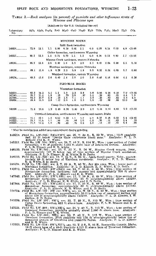
TABLE 3. Rock analyses (in percent) of pumicite and other tuffaceous strata of Miocene and Pliocene ages
[Analyses by the U.S. Geological Survey]
Laboratory Si0 2 A1203 Fe2 03 FeO MgO CaO Na2 O K20 TiO 2 P2 O 5 MnO H2 O CO2 No.
143218..
143217-.
148135..
148133..
148134..
72.0
69 ?,
68.3
68 1
69.3
12.1
12.5
12.8
11.8
13.0
MIOCENE ROCKS
Split Rock formation 1.1 0.90 0.19 0.81 2.1 6.0 0.22
Colter formation, northwestern Wyoming 1.5 0.74 0.70 1.1 1.2 6.0 0.24
Monroe Creek sandstone, western Nebraska 2.6 0.40 1.6 3.5 2.0 2.4 0.41
Harrison sandstone, western Nebraska 1.9 0.28 2.2 3.9 1.9 3.0 0.32
Marsland formation, eastern Wyoming 2.6 0.40 1.4 2.5 2.0 3.9 0.46
0.14
0.13
0.08
O.S4
0.16
0.02
0.02
0.06
0.03
0.04
4.9
7.7
5.5
5.7
4.5
<0.05
<-0 05
0.50
0 88
0.26
PLIOCENE ROCKS
Moonstone formation... 62.3... 70.7... 64.2... 58.8
14.211.410.714.5
3.51.81.92.8
1.2.15.10
1.12
1.0.79
1.52.0
2.22.87.11.8
2.6.97
1.13.3
3.65.43.93.5
0.86.29.26.42
0.36.05.02.06
0.10.03.03.08
7.9 <0.054.4 1.35. 2 4. 3
12. 0 .60
143219..147343..147344..154034.
143220........ 71.8 12.6
Camp Davis formation, northwestern Wyoming
1.2 0.40 0.30 0.80 2.0 5.8 0.24 0.14 0.02 5.9 <0.05
Teewinot formation, northwestern Wyoming and eastern Idaho143221........143222........143223........
71.172.171.3
12.111.812.4
1.51.11.0
0.82.86.50
0.32.18.40
1.1 1.7.84 1.6.76 2. 6
6.06.25.1
0.37.26.14
0.16.14.12
0.02.02.03
5.4 <0.055. 4 .106. 4 .06
Field No. LW-505 ; SE^NW^t sec. 25, T. 29 N., R. 89 W., Wyo.; 10-ft pumicitebed,, 32 ft below "Devils Gate vertebrate fossil zone." Analysts: P. L. D.Blmore and K. B. White.
Field No. LW-504 ; NB% sec. 29, T. 46 N., R. 114 W., Wyo.; type section of Colterformation, 1 ft of pumicite 4,335 ft above base of measured section. Analysts:P. L. D. Elmore and K. E. White.
Field No. LW-702 ; sec. 25, T. 32 N., R. 56 W., Monroe Creek canyon, Nebr.,approximately 110 ft below top of type section of Monroe Creek sandstone.Analysts : P. L. D. Elmore, K. E. White, 8. D. Botts.
Field No. LW-700 ; sec. 10, T. 28 N., R. 55 W., Agate fossil quarry, Nebr., approx imately 60 ft below top of Harrison sandstone. Analysts : P. L. D. Elmore,K. B. White, S. D. Botts.
Field No. LW-701; sec. 2, T. 29 N., R. 63 W., Jay Em area, Wyo. ; lower part ofMarsland formation. Analysts: P. L. D. Elmore, K. B. White, S. D. Botts.
Field No. LW-506 ; NW^SE^ sec. 19, T. 30 N., R. 89 W., Wyo.; type section ofMoonstone formation, dark-gray tuff marker bed approximately 800 ft abovebase. Analysts : P. L. D. Elmore and K. E. White.
Field No. LW-670 ; NW^SB^ sec. 17, T. 30 N., R. 89 W., Wyo. ; type section ofMoonstone formation, approximately 35 ft stratigraphically above 143219.Analysts : P. L. D. Blmore, K. B. White, and S. D. Botts.
Field No. LW-671 ; NW>iSEj4 sec. 17, T. 30 N., R. 89 W., Wyo.; type section ofMoonstone formation, approximately 60 ft stratigraphically above 147343.Analysts : P. L. D. Elmore, K. E. White, and S. D. Botts.
Field No. LW-787 ; SW cor. NW% sec. 34, T. 30 N., R. 89 W., Wyo. ; type sectionof Moonstone formation, approximately 90 ft below top of measured section andaboiit 450 ft strati^raphically above 143219. Analysts : P. L. D. Blmore, I. H.Barlow, S. D. Botts.
Field No. LW-507 ; SW% sec. 33, T. 39 N., R. 115 W., Wyo.; type section ofCamp Davis formation, 413 ft above base. Analysts: P. L. D. Elmore and K. B.White.
Field No. LW-508 ; SW^NE^d sec. 26, T. 42 N., R. 115 W. ( Wyo.; type section ofTeewinot formation, pumicite probably about 1,000 ft above base. Analysts :P. L. D. Elmore and K. E. White.
Field No. LW-509 ; NE}4 sec. 29, T. 42 N., R. 115 W., Wyo. ; type section ofTeewinot formation, 20-ft pumicite bed 195 ft stratigraphically below top ofmeasured section of limestone and pumicite facies. Analysts : P. L. D. Blmoreand K. B. White.
Field No. LWr-510 : SW^NB 1̂ sec. 10, T. 3 S., R. 46 E., Bonneville County, Idaho,10 ft above base of a 40-ft pumicite 4,315 ft above base of Teewinot formation.Analysts: P. L. D. Elmore and K. E. White.
1-24 CONTRIBUTIONS TO GENERAL GEOLOGY
upper and middle Eocene rocks. Along the west margin of the out crop area of Miocene strata the Split Eock formation overlaps upper and middle Eocene rocks.3 In the syncline south of the Continental fault system (fig. 2) the White River formation (Oligocene) and Bridger and Green River formations (both middle Eocene) underlie the Split Rock formation (Pipiringos, 1955; 1956; Love and others, 1955).
The Split Rock formation is preserved on and adjacent to the Granite Mountains (fig. 2) because it was folded into a broad asym metric syncline, here named the Split Rock syncline. This down- fold is more than 70 miles long, 30 miles wide, and has a maximum structural relief of about 3,000 feet. The south flank is the steeper. Both sides of the syncline are downdropped along normal faults, several of which are more than 20 miles long and have a few hundred to more than 1,000 feet of displacement.
AGE AND CORRELATION
The lower porous sandstone sequence is of early Miocene age and is equivalent to the Gering sandstone in the lower part of the Arikaree group of Nebraska. Rocks of this age have been found in the Wheatland area (fig. 1, loc. F) of eastern Wyoming (L. W. McGrew, oral communication, 1960).
The vertebrate fossils from the upper porous sandstone sequence are of middle Miocene age and correlate with part of the Hemingford group (Lugn, 1938) of Nebraska. This part of the Split Rock for mation correlates with strata containing a similar fauna in the Sara toga area (fig. 1, loc. C) 85 miles south-southeast of Split Rock and with at least part of the Browns Park formation, in the Maybell, Colo. area, 130 miles to the south-southwest (McGrew, 1951, p. 54- 57; 1953, p. 61-64; Montague, 1954, p. 1384). The Maybell area is 50 miles southeast of the type locality of the Browns Park formation.
It is possible that rocks of late Miocene age may be present in the southeastern part of the Split Rock area where the formation is nearly 3,000 feet thick. In the syncline south of the Continental fault system, Bell * reports Blastomeryx sp. and several teeth of an artiodactyl from the lower 150 feet of the Split Rock formation. P. O. McGrew (oral communication, 1959) says the artiodactyl is a camel similar to one he has collected from the Marsland formation of middle Miocene age in eastern Wyoming.
The Colter formation in Jackson Hole (fig. 1, loc. E), 180 miles northwest of Split Rock, is 7,000 feet thick, coarse grained, and con sists chiefly of locally derived basaltic and andesitic volcanic debris (Love, 1956, p. 1904-1907). Middle Miocene vertebrate fossils were
3 Bell, W. G., 1955, The geology of the southeastern flank of the Wind River Mountains, Fremont County, Wyoming: Wyoming Univ. Ph. D. thesis,, on open file.
* Op. cit., p. 127.
SPLIT ROCK AND MOONSTONE FORMATIONS, WYOMING 1-25
found 4,150 feet below the top of this formation. Volcanic vents in Jackson Hole may have furnished a large amount of the volcanic material in middle Miocene rocks farther east in Wyoming, inasmuch as the composition is very similar to that in the Split Rock formation (Houston, 1956, p. 136-137).
MOONSTONE FORMATION
NAME AND DEFINITION
A new name, Moonstone formation, is here used for a thick sequence of very soft white to brown claystone, shale, and tuffaceous sand stone and lesser amounts of limestone, conglomerate, and pumicite of Pliocene age. The Moonstone formation overlies the Split Rock formation with a slight angular unconformity. No rocks younger than the Moonstone are present in the type area. The formation derives its name from the Moonstone, a smooth monolith of Precambrian granite, against the steep face of which strata of the Moonstone formation were deposited. The Moonstone is located in sec. 32, T. 30 K, R. 89 W., Natrona County, Wyo., about 4 miles north of Split Rock, and is shown on the topographic sheet of the Lankin Dome quadrangle (fig. 2). The type section of the Moon stone formation extends from the SW^4 sec. 4, T. 30 N., R. 89 W. (fig. 3, loc. 12; fig. 5.5), southward to the stratigraphically highest bed in Vice Pocket, NE^NEi^SE^ sec. 33, T. 30 N., R. 89 W. (fig. 3, loc. 13).
Strata comprising the Moonstone and Split Rock formations were described as Pliocene by Endlich (1879, p. 112-113). His descrip tion, although generalized, is remarkably accurate. Subsequent to 1879, except for one publication (Love and others, 1955) in which the strata were identified as Pliocene and Miocene rocks, beds as signed to the Moonstone formation were considered part of the White River formation, or called Miocene rocks, undifferentiated.
The description that follows is based entirely on surface observa tions. The deepest well to penetrate the Moonstone formation is a water well 300 feet deep, from which no drill cuttings were collected.
Type section of Moonstone formation (fig. 3, Iocs. 12 and 13; fig. 5B)
[Base of section is in the center of sec. 4, T. 30 N., R. 89 W. Top of section is on pass at south end of Vice Pocket, NB%NE%SE% sec. 33, T. 30 N., R. 89 W., Natrona County, Wyo. Strata have average strike of N. 70° W., dip 2° SSW. Unit 1 is oldest]
Feet Moonstone formation:
47. Conglomerate, brownish-gray, with boulders commonly less than 1 ft in diameter; boulders in upper half are chiefly of black Precambrian igneous and metamorphic rocks in an arkose matrix; in lower half deeply weathered granite boulders are more abundant___________________________ 50
1-26 CONTRIBUTIONS TO GENERAL GEOLOGY
Type section of Moonstone formation (fig. 3, Iocs. 12 and 13; fig. 5B) Continued
Feet Moonstone formation Continued
46. Tuff, white, sandy, very limy, interbedded with soft buff sand stone similar to that in Split Rock formation, but more silty; interbedded with granitic conglomerate that is finer grained than that in overlying unit- __ _ SO
45. Conglomerate, brownish-gray, very coarse grained, with some granite boulders 5 ft in diameter and abundant black Pre- cambrian rock fragments as much as 1 ft in diameter 5
44. Sandstone and tuff, white to light-tan, very soft, interbedded with pumicite and claystone; rock analysis of pumicite is given in table 3 (lab. No. 154034) ; no pollen or diatoms-_ 10
43. Conglomeratic arkose, gray, tuffaceous; bouldery near granite knobs; finer grained in valley between knobs; forms weak gray ledges________________ _ 30
42. Sandstone, olive-drab, soft, tuffaceous, nodular, with manyconcentric-shelled nodules; slabby in part 25
41. Arkosic sandstone, gray, with limy matrix in lower 10 ft; grades up to greenish-drab tuffaceous sandstone; grain size averages about %o in., but some fragments of granite and black Precambrian rocks are 6 in. in diameter_________ 27
40. Limestone, brownish-gray, hard, sandy, lenticular; lenses out northward; grades up into overlying unit; contains abundant small irregular masses resembling algal growths 1. 5
39. Sandstone; lower half is brown and gray, fine grained, non- calcareous and forms cliff; upper half is pale greenish-gray with thin siliceous layers; thin bedded to crossbedded; abundant small (1-in. or smaller) nodules with concentric layers; some coarse-grained arkosic sandstone lenses; about middle is a 10-ft lens of greenish-white tuff that has been licked and gnawed by horses and rodents; upper 16 ft has brown-weathering heavy concretions as much as 1 ft in diameter_____________________ _ 98
38. Tuff, white to light-gray, very soft, light-weight, silty, sandy; numerous layers and nodules of chalcedony that are chalky white on outside and green on inside___ _ _ 12
37. Tuff, rusty-brown to olive-drab, soft, light-weight, sandy, abun dant glass shards, subangular quartz and plagioclase grains. 6
36. Sandstone, white to light-gray in lower 8 ft, grading up to light rusty brown; forms ragged ledges; conspicuous white zone at base; fine grained ; angular grains; some glass shards; brown limy concretions 1 to 3 ft in diameter; abundant small nod ules; very tuffaceous near top___________________ 24
35. Sandstone, buff, evenly bedded to crossbedded, fine-grained ex cept for some arkosic conglomerate at base; abundant chal- cedonic nodules at top; large brown limy concretions 1 to 3 ft in diameter in middle; some layers composed almost en tirely of sandstone nodules % in. in diameter__________ 50
SPLIT ROCK AND MOONSTONE FORMATIONS, WYOMING 1-27
Type section of Moonstone formation (fig. 3, Iocs. 12 and 13; fig. 5B) Continued
Feet Moonstone formation Continued
34. Tuff, white, soft; numerous brown chalcedony nodules; forms conspicuous white stripe on both, sides of spur at northeast margin of Vice Pocket; some gnarled stumps of silicified wood as much as 3 ft long and 1 ft thick; abundant bulbous masses with radial internal structures of unknown origin; also tabu lar masses with rows of angular pits of unknown origin 13
33. Tuff, buff, with some gray beds in middle, soft except for brown slabby layer 1 ft thick at top, which contains spectacular bulbous masses with radial internal structure of undeter mined origin _________________________ _ 7
32. Sandstone, rusty-brown, fine- to medium-grained, crossbedded, light-weight; abundant glass shards in upper part; lenticular arkosic conglomerate at top; forms lowest ragged ledge on spur at northeast margin of Vice Pocket _____ 1H
31. Sandstone and tuff, brown; breaks up into small irregular porous nodules; entire unit contains bulbous masses with radial internal structure_________ _ _ 10
30. Tuff, gray, soft, finely nodular, with brown tuff nodules and abundant gray to brown smooth flattened small chalcedony nodules______________________________ 6
29. Tuff, greenish-gray, brown-weathering, siliceous, very hard, very fine grained, with ropy appearance like a lava flow; numerous euhedral crystal cavities; many pink and white soft tuff inclu sions ; litters surface with irregular fragments__ _ 3
28. Tuff, gray, soft, with numerous small brown nodules- ___ 627. Tuff, light-gray, nodular, soft, with some thin gray laminated
silty limestone partings and dense hard pinkish-gray lime stone concretions as much as 3 ft in diameter; at top is a zone of bulbous masses as much as 3 ft in diameter with internal radial structure___________________ _ 15
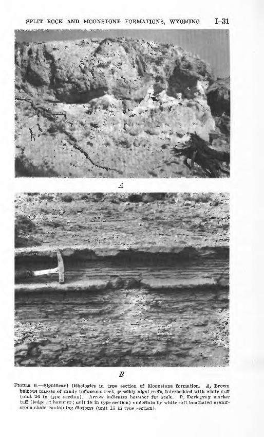
26. Tuff or tuffaceous sandstone; forms only a weak ledge on north side of White Ridge (ctr S% sec. 17, T. 30 N., R. 89 W.) but makes the most conspicuous ledge on the south side; unit is a contorted mass of large and small bulbous structures 5 to 10 ft in diameter (fig. QA), consisting of porous soft light weight rock with radial structure; abundant glass shards and fine sand grains; rock analysis given in table 3 (lab. No. 147344) __________________________________ 8
25. Tuff, white to rusty-tan, very soft; forms slope littered with small irregular tan limy and chalcedonic nodules; some gray limestone concretions weathering brown, as much as 1 ft in diameter; some bulbous masses 10 ft long and 3 ft thick with radial structure; some lenses of chalky-white tuff _ _ 23
24. Limestone, gray, brown-weathering, hard, in rounded nodules 1 to 3 ft in diameter; tuffaceous, with numerous glass shards and small sand grains _'. _________________________________ 2
23. Tuff, light-gray to white, very limy, very soft; forms slope above cliff; contains abundant small irregular brown chalced ony nodules that are gray on fresh fractures__________ 28

1-28 CONTRIBUTIONS TO GENERAL GEOLOGY
Type section of Moonstone formation (flff. 3, Iocs. 12 and 13; flff. 5B) Continued
Feet Moonstone formation Continued
22. Tuff, tan, laminated in part, massive in part, tuffaceous, soft, but forms top of cliff; porous, very light weight; abundant glass shards near top; rock analysis given in table 3 (lab. No. 147343) _______________________________ 9
21. Shale, white soft except in upper 6 ft. fissile, flaky, silty; dark brown to black chalcedony laminae and laminated lenses are so abundant in top 6 ft that this part of unit forms lower half of cliff; some frondlike structures on chalcedony bedding planes; some beds slightly radioactive; unit (but not local ity) of USGS Diatom Loc. 4711 (table 2) ____________ 21
20. Tuff, light-tan, coarsely bedded, soft, light-weight, porous; abundant glass shards; traces of bulbous masses with inter nal radial structure ___ ___ 5. 5
19. Shale, white, soft, laminated, silty, tuffaceous, light-weight, weathering into slightly curled cakes; at top are white egg- shaped nodules as much as 6 in. in diameter with black con centrically layered chalcedony centers ; no pollen or diatoms 5
18. Tuff, dark-gray, thin-bedded, ripple-marked, soft, porous, light weight, composed of needle-shaped glass shards, sodic ande- sine, quartz(?), and brown glass in clayey matrix; is a con spicuous marker bed recognizable throughout several square miles (fig. 6B) _____________________ _ 1
17. Shale, white, soft laminated, silty, tuffaceous, light-weight, weathering into slightly curled cakes; moderately radioac tive, with one persistent radioactive zone 6 in. to 1 ft thick 5 ft below top; unit (but not locality) containing USGS Diatom Locs. 4695 and 4709 (table 2)______________ 30
16. Tuff, tan to white, sandy and silty in part; abundant glass shards; some beds massive, others at base and top are finely laminated; some crinkled layers and bulbous masses resem bling algal reefs; forms conspicuous tan ledge; no diatoms 19
15. Sandstone, gray, with limonite stains on bedding planes, very tuffaceous; abundant glass shards; fine grained, light weight, spongy, porous, slightly calcareous, thin bedded; forms weak ledge; no diatoms; approximate unit (but not locality) con taining vertebrate fossils and silicifled wood__________ 7
14. Tuff, gray, very soft; forms persistent reentrant between twocliffs ___________________________________ 2
13. Sandstone, rusty-tan, hard, fine-grained, tuffaceous; forms cliff showing thin irregular bedding planes; lowest conspicuous tan cliff in exposure__________________________ 17.5
12. Tuff and shale, light-gray, very soft; tuff is silty and sandy, bedded, contains abundant glass shards; shale is in thin partings, very fine grained, flaky; appears bentonitic; nu merous dark-brown chalcedony nodules_____________ 14
11. Tuff and tuffaceous siltstone, greenish-gray to rusty-tan, finely nodular throughout; forms soft slope; moderately radioac tive zone 15 ft above base______________________ 40

SPLIT ROCK AND MOONSTONE FORMATIONS, WYOMING 1-29
Type section of Moonstone formation (fig. 3, Iocs. 12 and 13; fiff. SB) Continued
Feet Moonstone formation Continued
10. Pumicite, light-gray, soft, porous, impure, massive, sandy; abundant needle-shaped pink glass shards; some small cylin drical concretions; forms lowest conspicuous ledge in out crop ____________________________________ 11.5
9. Tuff and pumicite, dull-gray massive near base and in middle,porous, nodular ; abundant glass shards____________ 22
8. Tuff, gray and finely nodular in lower part; rusty-tan in upper;very soft and porous_______ _ ___ _ _ 25
7. Tuff and pumicite, dull-gray, massive, porous; abundant glassshards _________________________________ 18
6. Tuff, white to light-gray dense except for small tubes, hard_ 15. Tuff and pumicite, dull-gray massive, porous; composed chiefly
of colorless lath-shaped glass shards_______________ 22
4. Sandstone and tuff, pale-green, brown, and greenish-gray, soft, poorly bedded, porous, with abundant green balls and cylin drical concretions about 1 in. thick and more than 6 in. long; a green fine-grained siliceous bed 1 ft thick at top_______ 18
3. Partly covered interval. Sporadic outcrops of nodular green ish-white sandy tuff and tuffaceous sandstone with numerous concentric-shelled concretions; near base contains granite boulders 1 ft or more in diameter, embedded in a greenish- white quartz grit___________________________ 400±
2. Partly covered interval. Poor exposures of granite boulders asmuch as 3 ft in diameter in a greenish-white quartz grit___ 160±
Total thickness of Moonstone formation____________ 1, 356±
Contact between Moonstone and Split Rock formations: only approximate because of poor exposures'in this locality.
Split Rock formation:1. Sandstone, white, massive, soft, porous; contains abundant
tiny rounded magnetite grains and larger red-coated rounded quartz grains. Thin section shows rock to be about 75 per cent crystals of plagioclase, quartz, sanidine, brown pyroxene, green amphibole, and opaque minerals. Glass shards are in form of stars, wishbones, and rectangles, and are highly altered__________________________________ 50
DISTRIBUTION AND THICKNESS
The Moonstone formation has a known outcrop area of about 60 square miles. It was deposited around high steep-sided granite knobs comprising the partly buried crest of the Granite Mountains. These granite knobs have somewhat protected the less resistant sedimentary rocks from Recent erosion in the area of the type section (fig. 55). Additional small remnants not shown on figure 2 are similarly pre served in other localities farther east in the Granite Mountains. Possibly some claystone along the trough line of the Split Kock syn-
1-30 CONTRIBUTIONS TO GENERAL GEOLOGY
cline 20 miles southeast of Split Rock may be part of the Moonstone formation. The type section, 1,356 feet thick, is the thickest remnant of the formation.
LITHOLOGY
The lithology of the Moonstone formation is given in the description of the type section. Along the southwest margin of outcrop, where the basal arkosic beds are better exposed than in the measured section, distinctive brown and gray translucent waterworn agates are abun dant. These agate pebbles were apparently derived from the under lying Split Rock formation and are associated with silicified wood and unidentifiable fragments of mammal leg bones.
About a mile west of the type section the lower 500 feet of the formation contains some remarkable agate-pebble "reefs" that crop out in low ledges extending for a mile or more. Most of the agates are brown and translucent without manganese dendrites, but some "moss agates" are present. Only a few agates are radioactive. The agates range from y± inch to 1% inches in diameter; many are rounded but some 'are angular. Most seem to have been formed in place in a tuffaceous sandstone matrix. Some bedded chalcedony occurs with the agates.
Conspicuous brown cliff-forming beds are present in the middle part of the Moonstone formation. These contain bulbous masses of sandy tuffaceous rocks as large as 10 feet (fig. 6A) , with spongy texture and radial internal structures. Richard Rezak (written communication, 1957) says these contain poorly preserved vegetative structures of chara. Table 3 shows two analyses of this rock (lab. Nos. 147343 and 147344). Euhedral crystal molds, from which some soluble mineral, possibly an evaporite salt, was leached, are abundant at several horizons within these beds.
The sandstone beds are characterized by angular grains of quartz and feldspar, some of wrhich were derived from adjacent granites of Precambrian age. However, many of the grains are fresh-appearing oligoclase or sodic andesine similar to the feldspars in Tertiary vol canic rocks in northwestern Wyoming. Many of the quartz grains do not have the strain shadows characteristic of Precambrian quartz in this area. Red-brown biotite and green biotite are common. Ortho- pyroxene, augite, and oxyhornblende are present in some thin sections but are rarely abundant. Glass shards may be pink or colorless, needle shaped, rectangular, or sickle shaped, and are common to abun dant in every thin section studied. A few sandstone beds contain rounded frosted quartz grains similar to those in the Split Rock for mation. Tiny rounded magnetite grains so common in the Split Rock formation are sparse in the Moonstone.
SPLIT ROCK AND MOONSTONE FORMATIONS, WYOMING 1-31
FIGURE 6. Significant llthologles in type section of Moonstone formation. At Brown bulbous masses of sandy tuffaceous rock, possibly algal reefs, interbedded with white tuff (unit 26 In type section). Arrow indicates hammer for scale. B, Dark-gray marker tuff (ledge at hammer ; unit 18 In type section) underlain by white soft laminated uranif- erous shale containing diatoms (unit 17 in type section).
1-32 CONTRIBUTIONS TO GENERAL GEOLOGY
Within one of the sandstone units (unit 39 of the type section) is a 10-foot thick lens of greenish-white tuff that has been exten sively licked and gnawed by horses, game animals, and rodents. An analysis of this rock shows 0.54 percent sodium and 0.94 percent chlorine.
Most of the strata in the middle third of the formation appar ently were deposited in and along the margins of a lake which, at times, was shallow and alkaline. The size and shape of this lake, here called Moonstone Lake, are not known, but it certainly covered more than 50 square miles and probably extended throughout a much larger area. It persisted during the deposition of at least 500 feet of strata, thus suggesting that the Granite Mountains continued to sink along the trough line of the Split Rock syncline. If this interpretation is correct, the lake probably had an areal extent of several hundred square miles along the present site of the syncline.
A distinctive sequence of white shale (units 17-21, type section), about 60 feet thick, was deposited in Moonstone Lake, about 800 feet above the base of the formation. The shale is laminated, light weight, and extremely fissile (fig. 6B). Glass shards are abundant in the coarser-grained laminae. Individual beds 3 to 6 inches thick within the shale can be recognized throughout an area of 3 or more square miles, so conditions at the time of deposition of these beds must have been quiescent. Thicker white shale beds can be recog nized throughout the White Eidge area (fig. 5Z?). Some contain significant quantities of uranium.
Contemporaneous with deposition of the white shale was the growth of 5 or more "reefs" of algal limestone. Eroded remnants of these range in size from 1,000 feet in diameter and 20 feet in thickness to 60 feet in diameter and 3 feet in thickness. The lime stone is coarsely crystalline, gray, spongy, and soft. Some of it is structureless; other parts show crinkled bedding and outlines of bar rel-shaped masses several feet in diameter. Four of these "reefs" contain uranium and (or) thorium.
ANALYTICAL DATA
Sieve analyses of 7 random samples of tuffaceous sandstone show that 85 percent of the sandstone is in the size range 0.050 mm to 0.25 mm, distributed as shown below. Specific gravity of these sandstone samples averages 1.98.
Sine range, in mm Percent 0. 050-0. 062 _______________________________ 9. 5 .062- .088 _______________________________ 12.5 .088- .125 _______________________________ 29.4 . 125- . 175 _________________________________ 28. 4 . 175- . 25 _________________________________ 5. 0
SPLIT ROCK AND MOONSTONE FORMATIONS, WYOMING 1-33
Rock analyses were made of four samples of tuffaceous rocks in the Moonstone formation (table 3). The silica content is consider ably lower than that in most of the other samples of Miocene and Pliocene rocks listed for comparison. So few analyses are available, however, that this difference may be the result of chance.
Two water wells have been drilled in the Moonstone formation. Water from these wells and from two springs adjacent to granite knobs were analyzed for uranium. The water contains an average of 28 parts per billion uranium, more than 3 times as much as the average for water in the underlying Split Rock formation.
Seven layers in the middle part of the Moonstone formation con tain uranium that is considered by the writer to be syngenetic. Se lected specimens of the most radioactive parts of these layers have a uranium content that ranges from 0.003 percent to 0.025 percent. The uranium is present in a variety of rock types such as white shale, (fig. QB) white clay stone, relatively pure algal limestone, and brown and greenish-white tuff. The uranium-bearing layers range in thick ness from 1 inch to several feet. None of the samples contains as much as 1 percent P2O5 .
The abnormally high uranium content of the rocks and water of the Moonstone formation suggests that a considerable amount of the uranium in the Gas Hills area 10 miles to the north and in the Crooks Gap area 15 miles to the southwest (fig. 2) may have been leached from the Moonstone formation before it was removed by erosion from these places.
Five samples of radioactive algal limestone from the middle part of the formation (fig. 3, loc. 19) contain 0.11, 0.088, 0.14, 0.16, and 0.054 percent Th.232 J. N. Rosholt (written communication, 1958) states that one sample of the limestone contains about 3 percent in soluble material which, when separated, contains 4.75 percent thori um. An unnamed thorium mineral has been isolated (J. R. Dooley, Jr., oral communication, 1960) from samples of this limestone.
Salt licks and crystal molds of an unknown soluble mineral are present in several parts of the Moonstone formation. Some of the sodium salts in the "soda lakes" adjacent to outcrops of the Moon stone formation (fig. 3, Iocs. 8, 9, and 11) may have been leached from this formation.
STRATIGRAPHIC AND STRUCTURAL RELATIONS
The Moonstone formation is in contact with Precambrian rocks and with the Split Rock formation. The Precambrian surface on which the Moonstone formation was deposited was mountainous. In the type area of the formation, many granite peaks have a relief of 1,000 feet or more in a horizontal distance of 14 to */& mile (fig.
1-34 CONTRIBUTIONS TO GENERAL GEOLOGY
The present topography on the grainte in the Granite Moun tains is about the same as it was at the time the Moonstone formation was being deposited.
In areas where both the Split Rock and Moonstone formations are present, the basal beds of the Moonstone were deposited in shallow channels cut in the underlying Split Rock. Contact relief is rarely more than 50 feet in a horizontal distance of 300 feet. The Moonstone formation dips about 1° to 2° SSW., whereas the underlying Split Rock formation dips about 2° to 4° SSE. The slight divergence of average strike and the lesser dip in the Moonstone formation suggest that downwarping of the Split Rock syncline was in progress before deposition of the Moonstone formation began.
AGE AND CORRELATION
The Pliocene age of the Moonstone formation is based on diatom assemblages collected about 800 feet above the base of the formation at several localities (table 2). Concerning these assemblages, K. E. Lohman (written communication, 1959) says:
Five extinct species * * * have been named and described in my manuscript of the Cenozoic nonmarine diatoms from the Great Basin. Anomoeoneis sp. A has been found previously only in the Esmeralda formation of early Pliocene age in Nevada. The remaining four extinct species have known geologic ranges of late middle Miocene to middle Pliocene. _
With the exception of the 5 extinct species, all others are still represented in living assemblages elsewhere, although nearly all have known geologic ranges from various parts of the Late Tertiary to Recent. Ten of these species have known geologic ranges of late Middle Miocene to Recent, 4 have ranges of middle Pliocene to Recent. Based upon this somewhat conflicting evidence, the best age assignment that can be made is approximately early to middle Pliocene. When present studies of the diatoms from the middle Pliocene Teewinot for mation are completed, a comparison of the two assemblages may sharpen this assignment.
All of the diatoms in this assemblage are fresh-water lacustrine temperate species, although a few of them can also live in saline nonmarine waters. Both bottom-dwelling and pelagic species are present and this, coupled with the presence of large amounts of clastic material and volcanic glass, suggests that the lake was shallow and turbid.
The basal conglomerate contains unidentifiable fragments of large mammal leg bones. At about the middle of the Moonstone formation (approximate stratigraphic equivalent of unit 15, type section) in the NWi4NW% sec. 30, T. 30 N., R. 89 W. (fig. 3, loc. 18), is a zone of white to light-gray tuffaceous sandstone 10 to 30 feet thick that contains sparse mammal bones and teeth. One distal end of a camel id cannon bone was found. G. E. Lewis (written communication, 1958) says: "Morphologically, it can be duplicated in the corresponding part of several late Miocene and Pliocene genera of camels."

SPLIT ROCK AND MOONSTONE FORMATIONS, WYOMING 1-35
Several small teeth were collected from anthills in this same locality and zone. They were examined by R. W. Wilson (written commu nication, 1959), who identified the following items: a fourth upper premolar of an entoptychine rodent, fragment of a tooth of a geomoid rodent, incisors of at least 3 kinds of rodents, and tooth enamel of a small unidentifiable ungulate (?). These were not sufficiently diag nostic to be used in age determination.
Pollen from the middle of the formation were identified by E. B. Leopold (written communication, 1958) as belonging to various Com- positae, Artemisia, Pinus, Tsuga cf. T. heterophyUa, Picea, Sarco- l>atus, Vermiculatus, cf. Ostrya, Zelkova, and Betula. These indicate only a Miocene or Pliocene, age.
Fossil wood is abundant in several layers near the middle, and also a few hundred feet above the middle of the formation, but most of it is so completely silicified that identification is difficult. R. A. Scott (written communication, 1958) identified conifers, Zelkova, and a woody climbing vine.
No specific correlations with Pliocene rocks in eastern (fig. 1, Iocs. Gr and H) or northwestern (fig. 1, loc. E) Wyoming can be made with assurance on the basis of the known fossils, but inasmuch as many fossil types are present, it is likely that additional search will yield diagnostic material.
REFERENCES
Bauer, C. M., 1934, Wind River Basin: Geol. Soc. America Bull., v. 45, p. 665-696.Black, C. C., 1958, A new sicistine rodent from the Miocene of Wyoming: Cam
bridge, Mass., Mus. Comp. Zoology, Breviora, no. 86.Black, C. C., and Wood, A. E., 1956, Variation and tooth replacement in a Mio
cene Mylagaulid rodent: Jour. Paleontology, v. 30, no. 3, p. 672-684.Campbell, M. R., Emery, W. B., Heald, K. C., Stose, G. W., Stanton, T. W., Sears,
J. D., and others, 1925, Geologic map of Wyoming: U.S. Geol. Survey.Carey, B. D., Jr., 1955, A review of the Browns Park formation, in Rocky Mtn.
Assoc. Petroleum Geologists Guidebook, 1955: p. 47-49.Endlich, F. M., 1879, Report on the geology of the Sweetwater district, in
Hayden, F. V., Eleventh annual report of the United States Geological and Geographical Survey of the Territories, embracing Idaho and Wyoming, being a report of exploration for the year 1877: Washington, U.S. Govt. Printing Office.
Granger, Walter, 1910, Tertiary faunal horizons in the Wind River Basin, Wyoming, with descriptions of new Eocene mammals: Am. Mus. Nat. History Bull., v. 28, art. 21.
Hayden, F. V., 1861, Sketch of the geology of the country about the headwaters of the Missouri and Yellowstone Rivers: Am. Jour. Sci., v. 31, p. 229-245.
1869, Geological report of the exploration of the Yellowstone and Missouri Rivers, 1859-60: Washington, U.S. Govt. Printing Office.
1872, Preliminary report of the United States geological survey of Wy oming and portions of contiguous Territories, being a second annual report of progress for 1870: Washington, U.S. Govt. Printing Office.

1-36 CONTRIBUTIONS TO GENERAL GEOLOGY
Houston, R. S., 1956, Preliminary report on the petrography of Tertiary volcanic rocks of the Jackson Hole area, Teton County, Wyoming, in Wyoming Geol. Assoc. Guidebook llth Ann. Field Conf., 1956: p. 133-139.
Knight, S. H., 1955, Review of the early geological explorations of the Green River Basin area, 1812-1879, in Wyoming Geol. Assoc. Guidebook : 10th Ann. Field Conf. 1955: p. 10-17.
Knight, W. C., 1900, A preliminary report on the artesian basins of Wyoming: Wyoming Univ. Exp. Sta. Bull. 45, p. 107-251.
Leidy, Joseph, 1870, Remarks on a collection of fossils from the Western Terri tories: Philadelphia Acad. Nat. Bci. Proc., v. 22, p. 109-110.
1873, Contributions to the extinct vertebrate fauna of the Western Terri tories, in Hayden, F. V., United States Geological and Geographical Survey of the Territories, Pt. 1: Washington, U.S. Govt. Printing Office.
Love, J. D., 1939, Geology along the southern margin of the Absaroka Range, Wyoming: Geol. Soc. America Spec. Paper 20.
1956, New geologic formation names in Jackson Hole, Teton County,northwestern Wyoming: Am. Assoc. Petroleum Geologists Bull., v. 40, no. 8,p. 1899-1914.
Love, J. D., Weitz, J. L., and Hose, R. K., 1955, Geologic map of Wyoming: U.S.Geological Survey.
Lugn, A. L., 1938, The Nebraska State Geological Survey and the "Valentineproblem": Am. Jour. Sci., 5th ser., v. 36, no. 213, p. 220-227.
McGrew, P. O., 1951, Tertiary stratigraphy and paleontology of south-fentralWyoming, in, Wyoming Geol. Assoc. Guidebook 6th Ann. Field Conf., 1951:p. 54-57.
1953, Tertiary deposits of southeastern Wyoming, in Wyoming Geol.Assoc. Guidebook 8th Ann. Field Conf., 1953 : p. 61-64.
Marcou, Jules, 1853, Geologic map of the United States and the British Provincesof North America : Boston, Gould and Lincoln.
Montagne, John de la, 1954, Tertiary structure, fauna, and lithology in the UpperSaratoga Valley-Big Creek Park area, Wyoming and Colorado [abs.] : Geol.Soc. America Bull., v. 65, no. 12, p. 1384.
Montagne, John de la, and Barnes, W. C., 1957, Stratigraphy of the North Parkformation in the North Park area, Colorado, in Rocky Mtn. Assoc. PetroleumGeologists Guidebook, 1957: p. 55-60.
Osterwald, F. W., and Osterwald, D. B., 1952, Wyoming mineral resources:Wyoming Geol. Survey Bull. 45.
Pipiringos, G. N., 1955, Tertiary rocks in the central part of the Great DivideBasin, Sweetwater County, Wyoming, in Wyoming Geol. Assoc. Guidebook10th Ann. Field Conf., 1955: p. 100-104.
1956, Uranium-bearing coal in the central part of the Great Divide Basin, Sweetwater County, Wyoming: U.S. Geol. Survey, open-file report and map.
Schultz, C. B., and Falkenbach, C. H., 1940, Merycochoerinae, a new subfamily of oreodonts: Am. Mus. Nat. History Bull., v. 77, art. 5, p. 213-306.
Skolnick, Herbert, 1959, Miocene meteoric dust [abs.] : Geol. Soc. America Bull., v. 70, no. 12, p. 1787.
Stokes, W. L., and Varnes, D. J., 1955, Glossary of selected geologic terms: Colorado Sci. Soc. Proc., v. 16.
Thorpe, M. R., 1937, The Merycoidodontidae An extinct group of ruminant mam mals : Peabody Mus. Nat. History Mem., v. 3, pt. 4.
SPLIT ROCK AND MOONSTONE FORMATIONS, WYOMING 1-37
Van Houten, F. B., 1950, Geology of the western part of the Beaver Divide area, Fremont County, Wyoming: U.S. Geol. Survey Oil and Gas Inv. Map OM-113.
1954, Geology of the Long Creek-Beaver Divide area, Fremont County, Wyoming: U.S. Geol. Survey Oil and Gas Inv. Map OM-140.
1955, Volcanic-rich middle and upper Eocene sedimentary rocks northwest of Rattlesnake Hills, central Wyoming: U.S. Geol. Survey Prof. Paper 274-A.
Van Houten, F. B., and Weitz, J. L., 1956, Geologic map of the eastern Beaver Divide, Gas Hills area, Fremont and Natrona Counties, Wyoming: U.S. Geol. Survey Oil and Gas Inv. Map OM-180.

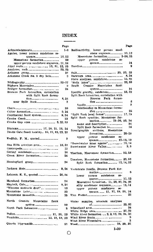
INDEX
PageAcknowledgments__ __ _ 1 3 Agates, lower porous sandstone se
quence_____-_ __ 10,12 Moonstone formation____ 30 upper porous sandstone sequence- 11,14
Algal reefs___________ 15, 31, 32, 33 Analyses, rock_____ 23, 33 Arikaree group 24 Arkansas Creek No. 1 dry hole __ 9
Bibliography________________ 35-37 Bighorn Mountains___________ 9 Bridger formation___________ 24 Browns Park formation, correlation
with Split Rock forma tion_______ __ 8, 24
near Split Rock__________ 3
Chara____________________ 30 Colter formation 9, 24 Continental fault system________ 9, 24 Crooks Creek _ __ 22 Crooks Gap area___________ 5, 22, 33
Diatoms___________ 17, 20, 21, 28, 34 Devils Gate fossil locality. 15, 17,19, 22, 23
Endlich, F. M., quoted________ 3
Gas Hills uranium area________ 10, 33Gastropods__________ ___ 12Gering sandstone_____ __ 24Green River formation__ __ 24
Hemingford group.
PageRadioactivity, lower porous sand
stone sequence-- _ 10,12 Moonstone formation 1-30, 33 upper porous sandstone- se
quence- 14 Rawlins____________________ 9
Salt___________________ 30, 32, 33Saratoga area _ 8, 24 Sieve analyses, sandstone 15, 32 "Soda lakes"_________ _ 22,33South Granite Mountains fault
system. _ _ 14 Specific gravity, sandstone 15, 32 Split Rock formation, correlation with
Browns Park forma tion _______ ____ 8
fossils __________________ 3 relationship to Moonstone forma
tion ________ ____ 25"Split Rock local fauna"________ 17, 19 Split Rock syncline, Moonstone for
mation______ 29-30, 32, 34 name and description- 24 Split Rock formation in_ ___ 14
Stratigraphic sections, Moonstoneformation___________ 25-29
upper porous sandstone se quence________ 17-18, 19
"Sweetwater moss agates" 11,14 Sweetwater River Valley _ 2, 3
Thorium, Moonstone formation _ 32, 33
Uranium, Moonstone formation-. 32, 33 Split Rock formation____ 12,14, 22
Jackson Hole____________ 9, 24 Vertebrate fossils, Browns Park for-
Lohman, K. E., quoted_________ 20, 34
Marsland formation ___ 24Maybell, Colo_____________ 8,24"Miocene meteoric dust"_______ 12Moonstone Lake_____________ 32
mation__ _ __ 8 lower porous sandstone se
quence- 11,12 Moonstone formation. 11, 28, 30, 34, 35 silty sandstone sequence- __ 11,14 upper porous sandstone se
quence__ 11, 17, 19, 20, 24Moonstone monolith. 25 Vice Pocket- 25
North Granite Mountainssystem______
North Park formation___
fault10
8
Pollen________________ 17, 21, 35 Pumicite_____________ 12, 15, 18, 22
Quartz bipyramids. 13
Water samples, uranium analysesof _____________ 22, 33
Wheatland area_____ _ _ _^_ 24 White Ridge area______________ 27,32White River formation__ 2, 3,12, 22, 24, 25 Wind River Basin______ 9 Wind River Mountains 3 Wood_________________ 28, 30, 35
o1-39