Embed Size (px)
Citation preview
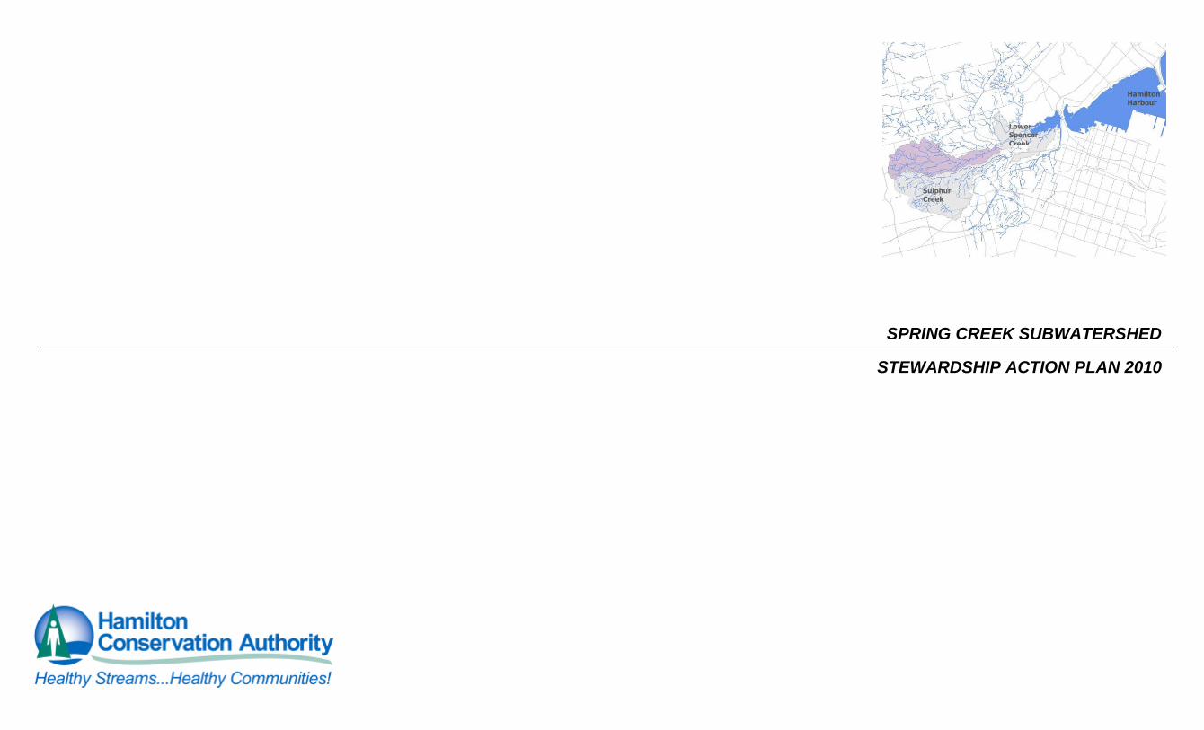
SPRING CREEK SUBWATERSHED
STEWARDSHIP ACTION PLAN 2010
Hamilton Harbour
Lower Spencer
Creek
Sulphur Creek

TABLE OF CONTENTS
SPRING CREEK SUBWATERSHED CHARACTERIZATION……………………………………………………………………………………………………………..SP-1
GEOGRAPHIC LOCATION……………………………………………………………………………………………………………………………………………………………………………………………………… SP-1
HYDROLOGY……………………………………………………………………………………………………………………………………………………………………………………………………………………… SP-3
SOILS AND PHYSIOGRAPHY…………………………………………………………………………………………………………………………………………………………………………………………………… SP-5
NATURAL HISTORY AND SIGNIFICANT SPECIES……………………………………………………………………………………………………………………………………………………………………… SP-7
CULTURAL HISTORY…………………………………………………………………………………………………………………………………………………………………………………………………………… SP-11
STEWARDSHIP HISTORY……………………………………………………………………………………………………………………………………………………………………………………………………… SP-13
STRESSES AND STEWARDSHIP ACTIONS…………………………………………………………………………………………………………………………………..SP-14
CATCHMENT SUMMARIES………………………………………………………………………………………………………………………………………………….....SP-37
COPETOWN EAST DATA SHEETS…………………………………………………………………………………………………………………………………………………………………………...SP-37
LOWER SPRING CREEK DATA SHEET………………………………………………………………………………………………………………………………………………………………….......SP-40
MIDDLE SPRING CREEK DATA SHEETS…………………………………………………………………………………………………………………………………………………………………...SP-43
SOUTHERN HEADWATERS DATA SHEETS…………………………………………………………………………………………………………………………………………………………………SP-46
WEIR’S LANE DATA SHEETS………………………………………………………………………………………………………………………………………………………………………………...SP-49
LIST OF MAPS MAP SP-1: SPRING CREEK SUBWATERSHED AND CATCHMENTS…………………………………………………………………………………………………………………………………………….SP-2
MAP SP-2: SOIL TYPE (1965) …………………………………………………………………………………………………………………………………………………………………………………………SP-4
MAP SP-3: NATURAL HISTORY…………………...…………………………………………………………………………………………………………………………………………………………………SP-6
MAP SP-4: CURRENT LANDUSE……………………………………………………………………………………………………………………………………………………………………………………SP-10
MAP SP-5: STEWARDSHIP HISTORY………………………………………………………………………………………………………………………………………………………………………………SP-12
MAP SP-6: COPETOWN EAST CATCHMENT……………………………………………………………………………………………………………………………………………………………………...SP-37
MAP SP-7: LOWER SPRING CREEK CATCHMENT……………………………………………………………………………………………………………………………………………………………….SP-40
MAP SP-8: MIDDLE SPRING CREEK CATCHMENT………………………………………………………………………………………………………………………………………………………………SP-43
MAP SP-9: SOUTHERN HEADWATERS CATCHMENT…………………………………………………………………………………………………………………………………………………………..SP -46
MAP SP-10: WEIR’S LANE CATCHMENT………………………………………………….……………………………………………………………………………………………………………………....SP-49
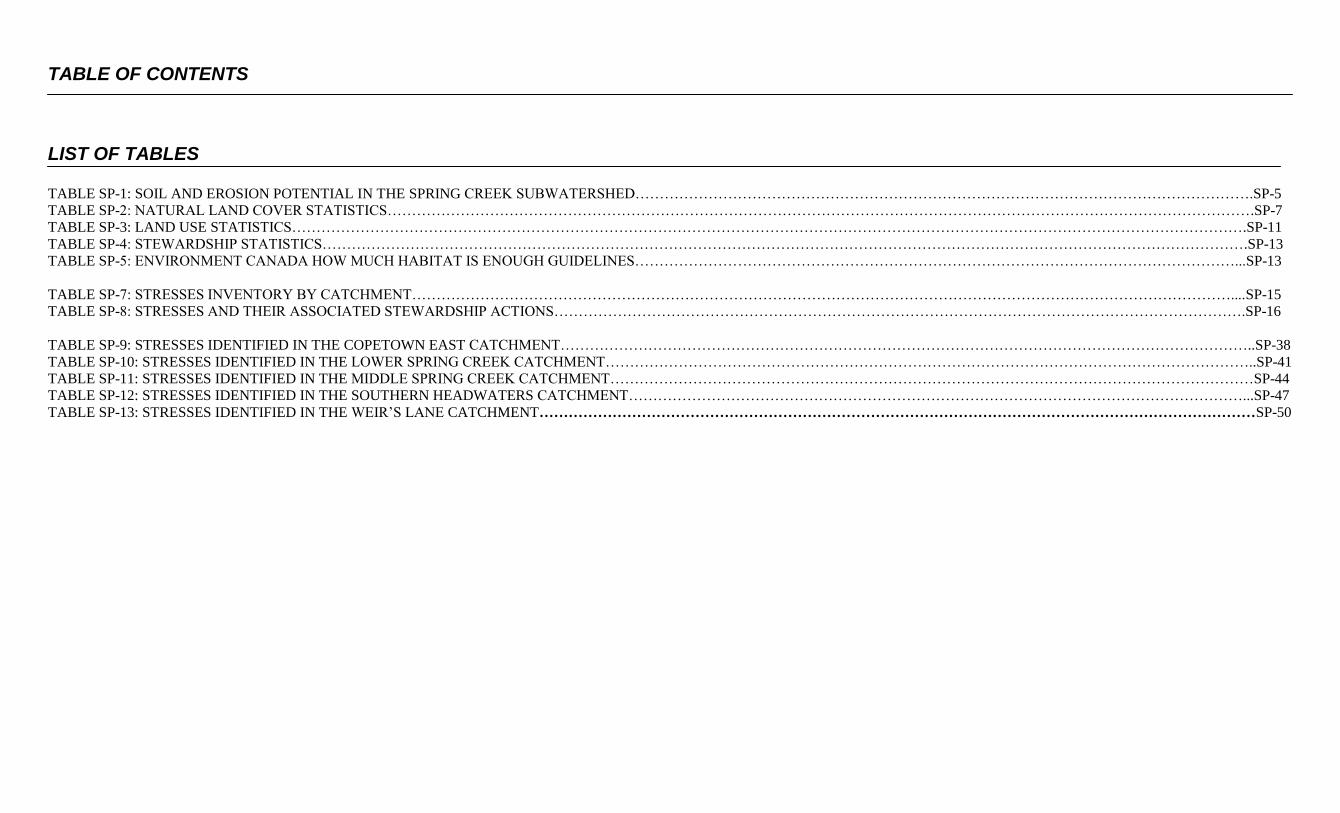
TABLE OF CONTENTS
LIST OF TABLES
TABLE SP-1: SOIL AND EROSION POTENTIAL IN THE SPRING CREEK SUBWATERSHED……………………………………………………………………………………………………………….SP-5
TABLE SP-2: NATURAL LAND COVER STATISTICS…………………………………………………………………………………………………………………………………………………………….SP-7
TABLE SP-3: LAND USE STATISTICS…………………………………………………………………………………………………………………………………………………………………………….SP-11
TABLE SP-4: STEWARDSHIP STATISTICS……………………………………………………………………………………………………………………………………………………………………….SP-13
TABLE SP-5: ENVIRONMENT CANADA HOW MUCH HABITAT IS ENOUGH GUIDELINES……………………………………………………………………………………………………………...SP-13
TABLE SP-7: STRESSES INVENTORY BY CATCHMENT……………………………………………………………………………………………………………………………………………………....SP-15
TABLE SP-8: STRESSES AND THEIR ASSOCIATED STEWARDSHIP ACTIONS…………………………………………………………………………………………………………………………….SP-16
TABLE SP-9: STRESSES IDENTIFIED IN THE COPETOWN EAST CATCHMENT……………………………………………………………………………………………………………………………..SP-38
TABLE SP-10: STRESSES IDENTIFIED IN THE LOWER SPRING CREEK CATCHMENT……………………………………………………………………………………………………………………..SP-41
TABLE SP-11: STRESSES IDENTIFIED IN THE MIDDLE SPRING CREEK CATCHMENT……………………………………………………………………………………………………………………SP-44
TABLE SP-12: STRESSES IDENTIFIED IN THE SOUTHERN HEADWATERS CATCHMENT………………………………………………………………………………………………………………...SP-47
TABLE SP-13: STRESSES IDENTIFIED IN THE WEIR’S LANE CATCHMENT…………………………………………………………………………………………………………………………………SP-50
SPRING CREEK SUBWATERSHED CHARACTERIZATION
SPRING CREEK STEWARDSHIP ACTION PLAN SP-1
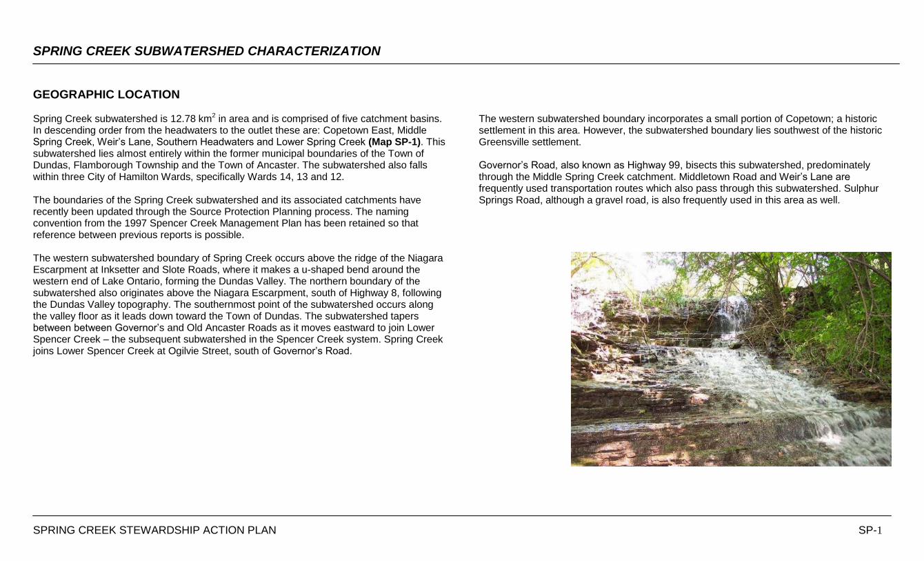
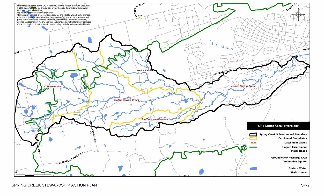
GEOGRAPHIC LOCATION Spring Creek subwatershed is 12.78 km2 in area and is comprised of five catchment basins. In descending order from the headwaters to the outlet these are: Copetown East, Middle Spring Creek, Weir‟s Lane, Southern Headwaters and Lower Spring Creek (Map SP-1). This subwatershed lies almost entirely within the former municipal boundaries of the Town of Dundas, Flamborough Township and the Town of Ancaster. The subwatershed also falls within three City of Hamilton Wards, specifically Wards 14, 13 and 12. The boundaries of the Spring Creek subwatershed and its associated catchments have recently been updated through the Source Protection Planning process. The naming convention from the 1997 Spencer Creek Management Plan has been retained so that reference between previous reports is possible. The western subwatershed boundary of Spring Creek occurs above the ridge of the Niagara Escarpment at Inksetter and Slote Roads, where it makes a u-shaped bend around the western end of Lake Ontario, forming the Dundas Valley. The northern boundary of the subwatershed also originates above the Niagara Escarpment, south of Highway 8, following the Dundas Valley topography. The southernmost point of the subwatershed occurs along the valley floor as it leads down toward the Town of Dundas. The subwatershed tapers between between Governor‟s and Old Ancaster Roads as it moves eastward to join Lower Spencer Creek – the subsequent subwatershed in the Spencer Creek system. Spring Creek joins Lower Spencer Creek at Ogilvie Street, south of Governor‟s Road.
The western subwatershed boundary incorporates a small portion of Copetown; a historic settlement in this area. However, the subwatershed boundary lies southwest of the historic Greensville settlement. Governor‟s Road, also known as Highway 99, bisects this subwatershed, predominately through the Middle Spring Creek catchment. Middletown Road and Weir‟s Lane are frequently used transportation routes which also pass through this subwatershed. Sulphur Springs Road, although a gravel road, is also frequently used in this area as well.
SPRING CREEK STEWARDSHIP ACTION PLAN SP-2
Base Mapping supplied by the City of Hamilton, and the Ministry of Natural Resources.
© 2010 Queen’s Printer for Ontario, City of Hamilton and Teranet Land Information Services Inc. and its licensors. May not be reproduced without permission.
All information provided is believed to be accurate and reliable. We will make changes, updates and deletions as required and make every effort to ensure the accuracy and quality of the information provided. However, the Hamilton Conservation Authority
assumes no responsibility for any errors or omissions and is not liable for any damages of any kind resulting from the use of, or reliance on, the information contained herein.
SPRING CREEK SUBWATERSHED CHARACTERIZATION
SPRING CREEK STEWARDSHIP ACTION PLAN SP-3
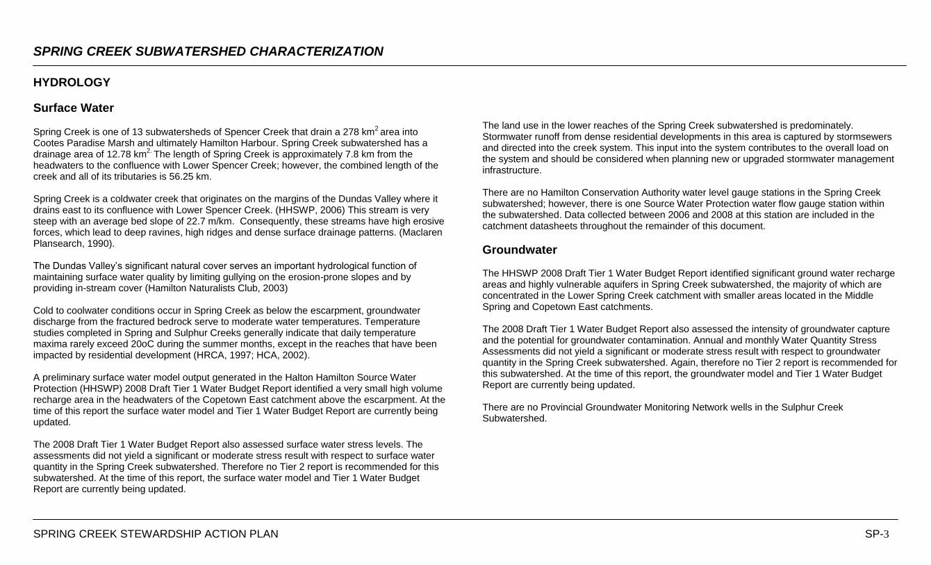
HYDROLOGY
Surface Water Spring Creek is one of 13 subwatersheds of Spencer Creek that drain a 278 km
2 area into
Cootes Paradise Marsh and ultimately Hamilton Harbour. Spring Creek subwatershed has a drainage area of 12.78 km
2. The length of Spring Creek is approximately 7.8 km from the
headwaters to the confluence with Lower Spencer Creek; however, the combined length of the creek and all of its tributaries is 56.25 km. Spring Creek is a coldwater creek that originates on the margins of the Dundas Valley where it drains east to its confluence with Lower Spencer Creek. (HHSWP, 2006) This stream is very steep with an average bed slope of 22.7 m/km. Consequently, these streams have high erosive forces, which lead to deep ravines, high ridges and dense surface drainage patterns. (Maclaren Plansearch, 1990). The Dundas Valley‟s significant natural cover serves an important hydrological function of maintaining surface water quality by limiting gullying on the erosion-prone slopes and by providing in-stream cover (Hamilton Naturalists Club, 2003) Cold to coolwater conditions occur in Spring Creek as below the escarpment, groundwater discharge from the fractured bedrock serve to moderate water temperatures. Temperature studies completed in Spring and Sulphur Creeks generally indicate that daily temperature maxima rarely exceed 20oC during the summer months, except in the reaches that have been impacted by residential development (HRCA, 1997; HCA, 2002). A preliminary surface water model output generated in the Halton Hamilton Source Water Protection (HHSWP) 2008 Draft Tier 1 Water Budget Report identified a very small high volume recharge area in the headwaters of the Copetown East catchment above the escarpment. At the time of this report the surface water model and Tier 1 Water Budget Report are currently being updated. The 2008 Draft Tier 1 Water Budget Report also assessed surface water stress levels. The assessments did not yield a significant or moderate stress result with respect to surface water quantity in the Spring Creek subwatershed. Therefore no Tier 2 report is recommended for this subwatershed. At the time of this report, the surface water model and Tier 1 Water Budget Report are currently being updated.
The land use in the lower reaches of the Spring Creek subwatershed is predominately. Stormwater runoff from dense residential developments in this area is captured by stormsewers and directed into the creek system. This input into the system contributes to the overall load on the system and should be considered when planning new or upgraded stormwater management infrastructure. There are no Hamilton Conservation Authority water level gauge stations in the Spring Creek subwatershed; however, there is one Source Water Protection water flow gauge station within the subwatershed. Data collected between 2006 and 2008 at this station are included in the catchment datasheets throughout the remainder of this document.
Groundwater The HHSWP 2008 Draft Tier 1 Water Budget Report identified significant ground water recharge areas and highly vulnerable aquifers in Spring Creek subwatershed, the majority of which are concentrated in the Lower Spring Creek catchment with smaller areas located in the Middle Spring and Copetown East catchments. The 2008 Draft Tier 1 Water Budget Report also assessed the intensity of groundwater capture and the potential for groundwater contamination. Annual and monthly Water Quantity Stress Assessments did not yield a significant or moderate stress result with respect to groundwater quantity in the Spring Creek subwatershed. Again, therefore no Tier 2 report is recommended for this subwatershed. At the time of this report, the groundwater model and Tier 1 Water Budget Report are currently being updated. There are no Provincial Groundwater Monitoring Network wells in the Sulphur Creek Subwatershed.
SPRING CREEK STEWARDSHIP ACTION PLAN SP-4
Base Mapping supplied by the City of Hamilton, and the Ministry of Natural Resources. © 2010 Queen’s Printer for Ontario, City of Hamilton and Teranet Land Information Services Inc. and its licensors.
May not be reproduced without permission. All information provided is believed to be accurate and reliable. We will make changes,
updates and deletions as required and make every effort to ensure the accuracy and quality of the information provided. However, the Hamilton Conservation Authority assumes no responsibility for any errors or omissions and is not liable for any damages
of any kind resulting from the use of, or reliance on, the information contained herein.
SPRING CREEK SUBWATERSHED CHARACTERIZATION
SPRING CREEK STEWARDSHIP ACTION PLAN SP-5
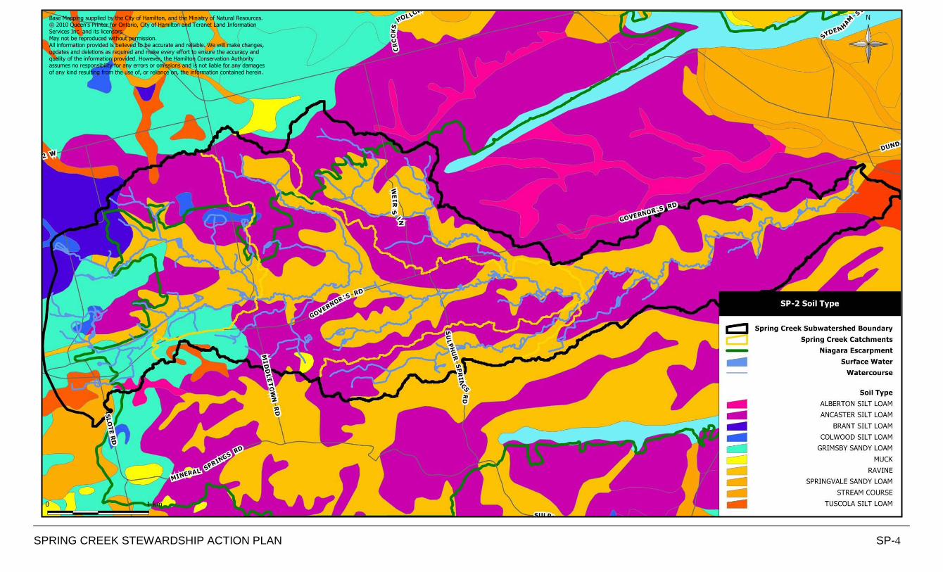
SOILS AND PHYSIOGRAPHY The soil parent materials in the Spencer Creek subwatershed are thought to have predominately been deposited during the Wisconsian glaciation and are frequently related to underlying or adjacent bedrock formations (HHSWP, 2006).
The Niagara Escarpment is a prominent feature in the Spencer Creek Watershed. It extends in a westerly direction from Stoney Creek at the southeast end of Hamilton to a point west of Dundas from where it then runs east-northeast to Waterdown. The configuration of the Escarpment is greatly influenced by the Dundas Valley. The Dundas Valley is a major re-entrant bedrock valley in the Niagara Escarpment that extends inland for approximately 12km from the western end of Lake Ontario (SNC Lavalin et al., 2004). It is believed that the Dundas Valley was formed through erosion of the escarpment by an ancient pre-glacial river that flowed into the area from the northwest. The east-west trending Dundas Valley is approximately 12km long, 4km wide and over 200m deep. The Dundas bedrock valley is a deep narrow central bedrock gorge within the re-entrant valley that runs west to east from Brantford through Dundas and to Lake Ontario. It is largely filled with glacial and post glacial deposits. The bedrock valley narrows west of the Lower Spencer Creek subwatershed but widens in Dundas following the trend of the escarpment (Hamilton Naturalists Club, 2003). Along the flanks of the valley, the ground surface elevation decreases from approximately 190 masl on the north slope and 120 masl on the south slope toward the centre of the valley to the shoreline (SNC Lavalin et al., 2004). Lacustrine deposits of the Iroquois Plain are found along the Lake Ontario Shoreline. As the Ontario Lobe of the glacier receded from the Lake Ontario Basin, Lake Iroquois was formed. Along the axis of the Dundas Valley, the ground surface slopes easterly from approximately 260 masl through Dundas to about 75 masl at the Lake Ontario Shoreline. A small number of creeks are incised into the slope of the valley. Lake Iroquois occupied an area significantly larger than the current shores of Lake Ontario. In Hamilton the Iroquois Plain is a relatively narrow plain located between the shore of Lake Ontario and the Niagara Escarpment. Sand and gravel bars such as the one that separates Hamilton Harbour from Lake Ontario are also present. Alluvial fan gravels are observed at the outlet of the Dundas Valley (Chapman and Putnam, 1984).
In the Dundas Valley, soil development in the extensive active ravines is limited. Other than the active ravines area of the valley, the dominant soil is well drained Ancaster silt loam (Hamilton Naturalists Club, 2003). The soil characteristics of the Spring Creek subwatershed are shown on Map SP-2. Seven soils complexes have been identified within this subwatershed, as summarized in Table SP-1. Soil characteristics vary throughout the subwatershed. The natural drainage of the soil ranges from poorly drained to well drained and the erosion potential ranges from low to moderate. Table SP-1: Soil and Erosion Potential in the Spring Creek Subwatershed
* Based on the Region of Hamilton-Wentworth Soil Summary Sheet ** Based on the Ontario Environmental Farm Plan Workbook, Ontario Farm Environmental Coalition
Soil Type Natural Drainage
Erosion Factor*
Topography (slope)
Erosion Potential
Gi – Grimsby Sandy Loam Well drained 4 6-9% Moderate
Sp – Springvale Sandy Loam Well drained 4 6-9% Moderate
Al – Alberton Silt Loam Variable N/A 1% Low
An – Ancaster Silt Loam Well drained 2 38% Moderate
Bt – Brant Silt Loam Well drained 1 7.5% Low
Co – Colwood Silt Loam Poor 2 1% Low
Tu – Tuscola Silt Loam Imperfect 2 3-5% Low
SPRING CREEK STEWARDSHIP ACTION PLAN SP-6
Base Mapping supplied by the City of Hamilton, and the Ministry of Natural Resources.
© 2010 Queen’s Printer for Ontario, City of Hamilton and Teranet Land Information Services Inc. and its licensors. May not be reproduced without permission.
All information provided is believed to be accurate and reliable. We will make changes, updates and deletions as required and make every effort to ensure the accuracy and
quality of the information provided. However, the Hamilton Conservation Authority assumes no responsibility for any errors or omissions and is not liable for any damages of any kind resulting from the use of, or reliance on, the information contained herein.

SPRING CREEK SUBWATERSHED CHARACTERIZATION
SPRING CREEK STEWARDSHIP ACTION PLAN SP-7
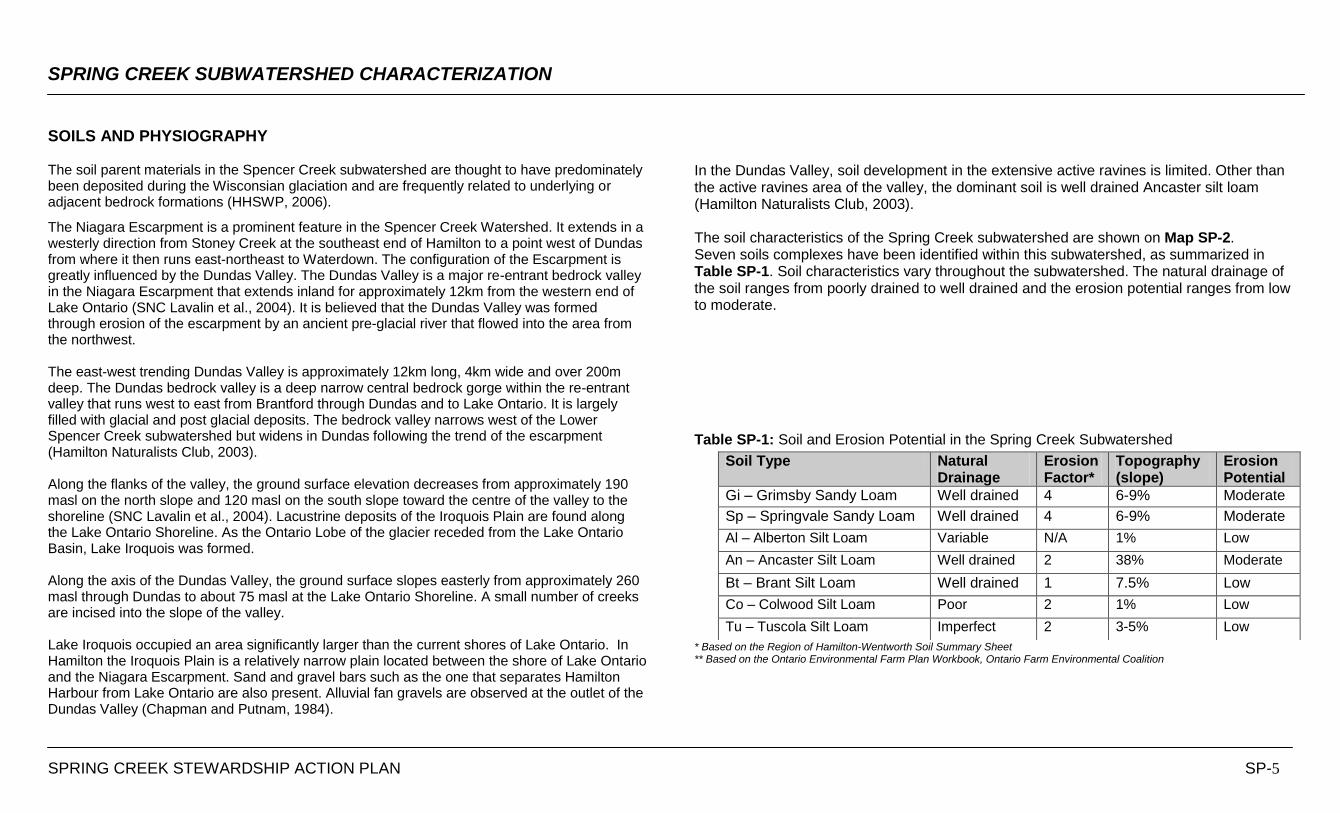
NATURAL HISTORY & SIGNIFICANT SPECIES The Niagara Escarpment, a UNESCO World Biosphere Reserve, is a prominent feature of this subwatershed; it allows for the unique natural history of the Dundas Valley ESA. Additionally, this subwatershed reaches into the Copetown Ball Park Woodlot, another municipally designated environmentally significant area (ESA). These natural areas are critical habitat and migratory corridors for terrestrial and aquatic species. Biophysical attributes of these areas were assessed in the Hamilton Natural Areas Inventory Nature Counts Project, Dwyer et at., 2003). Natural vegetation covers 5.78 km
2 or 45% of the Spring Creek subwatershed. The Hamilton
Conservation Authority owns many of these natural areas as they own 3.2 km2 or 38% of the
lands within the subwatershed. The current natural land cover statistics for the area are noted
within Table SP-2. Based on the digital data provided for this analysis, forest cover accounts for 41% of this subwatershed, while meadow cover is 4% of the land base. Stream length of Spring Creek and all its tributaries is 56.25 km. MapSP-3 illustrates that natural heritage of the Spring Creek subwatershed.
Less than 1% of the current landscape is wetland. Historically, this subwatershed had very little wetland cover. Historical wetlands mapping identifies that prior to 1967 only a 0.04 km
2 area of
wetland had been lost from this subwatershed in the Copetown East catchment. Historical information was not recorded for forest or meadow cover. It is known that land use throughout the 20
th century altered the natural heritage systems within this southern Ontario and that 90% of
the original upland woodlands were converted to non-forest land uses by 1920 (Larsen et al., 1999). However over the past eighty years many natural areas have regenerated. The Dundas Valley and Niagara Escarpment corridor are the predominant regenerated natural upland habitats.
Spring Creek occurs in a unique region where the Great Lakes - St. Lawrence and Deciduous forest regions interface. As a result the flora and fauna communities are very diverse and include many species that are at or near the northern or southern extent of their geographic range. (Rowe, 1972) The Dundas Valley ESA is located in the western end of the re-entrant valley extending into the former Town of Ancaster and the Spring Creek subwatershed. The core of this area consists of varied, relatively undisturbed, broadleaf and mixed upland woods consisting mainly of beech, maple, oak and hickory. The periphery consists of a patchwork of natural, successional and disturbed habitats that occur within the valley and along the outer valley slopes. This large natural area serves an important hydrological function of maintaining surface water quality in valley streams by limiting gullying on the erosion prone slopes and by providing in-stream cover (Dwyer, 2003).
Table SP- 2: Natural Land Cover Statistics
Forest Cover (km2)
Wetland Cover (km2)
Meadow Cover (km2)
Stream Length (km)
5.23 0.05 0.50 56.25
SPRING CREEK SUBWATERSHED CHARACTERIZATION
SPRING CREEK STEWARDSHIP ACTION PLAN SP-8
NATURAL HISTORY & SIGNIFICANT SPECIES Numerous fisheries and benthic macroinvertbrates monitoring stations have been sampled in Spring Creek between 1970 and 2009. Prior to the introduction of the HCA Aquatic Resources Monitoring Program (ARMP) in 2004, the data collected was sporadic. The ARMP now provides for routine monitoring of fish, fish habitat and benthic macroinvertebrates throughout the HCA watersheds. The parameters monitored allow for an assessment of ecological health. The ARMP now provides that two ecological monitoring stations in the Spring Creek subwatershed will be monitored in Year 2 of a three year cycle. The monitoring stations are in the Middle Spring and Lower Spring Creek catchments. The first year of fisheries data from the three year cycle are listed in the catchment datasheets in the remainder of this document. The first year of benthic data is not currently available due to the incomplete status of the Ontario Benthos Biomonitoring Network on-line database. However, all other available data for these and other historic monitoring stations are included in Appendix B. Although the ARMP includes a number of annual monitoring stations throughout HCA‟s watersheds, there are no annual stations in the Spring Creek subwatershed. The 2009 ARMP Report recommends the inclusion of an annual monitoring station in each subwatershed of Spencer Creek to build a more comprehensive dataset. Cold to coolwater conditions occur in Spring Creek as below the escarpment, groundwater discharge from the fractured bedrock serve to moderate water temperatures. Temperature studies completed in Spring and Sulphur Creeks generally indicate that daily temperature maxima rarely exceed 20oC during the summer months, except in the reaches that have been impacted by residential development (HRCA, 1997; HCA, 2002). Extensive forest cover through the Dundas Valley likely accounts for the maintenance of coldwater conditions in these reaches (Griffiths: 2000, 2002, 2003).
The main channel of Spring Creek was historically considered to provide coldwater habitat able to support trout populations (Department of Commerce and Development, 1960), and relatively unimpaired water quality conditions prevail throughout. Although some residential development has occurred throughout the subwatershed, this activity has not compromised water quality conditions in the creek (HHSWP, 2006). Along the main channel of this watercourse, high abundances of pollution-sensitive mayflies, caddisflies, stoneflies, and true flies within the benthic collections are indicative of coldwater conditions throughout the year (Griffiths; 2001, 2003). In the vicinity of Sulphur Springs Road, however, some impairment has been detected, as indicated by the presence of tubificid worm species tolerant of silt and organic matter accumulations (Griffiths, 2003). These impairments may be attributed to adjacent land uses including a nearby water taking and parking lot, as well as an upstream pond located adjacent to the watercourse. Given the coldwater characteristics of portions of this subwatershed, sensitive fish species that have been documented, both recently and historically, include rainbow darter, fantail darter, brassy minnow, finescale dace, pearl dace and northern redbelly dace (C. Portt and Associates, 1002: HRCA; 1997, 2000; HCA: 2002, 2005).
SPRING CREEK SUBWATERSHED CHARACTERIZATION
SPRING CREEK STEWARDSHIP ACTION PLAN SP-9
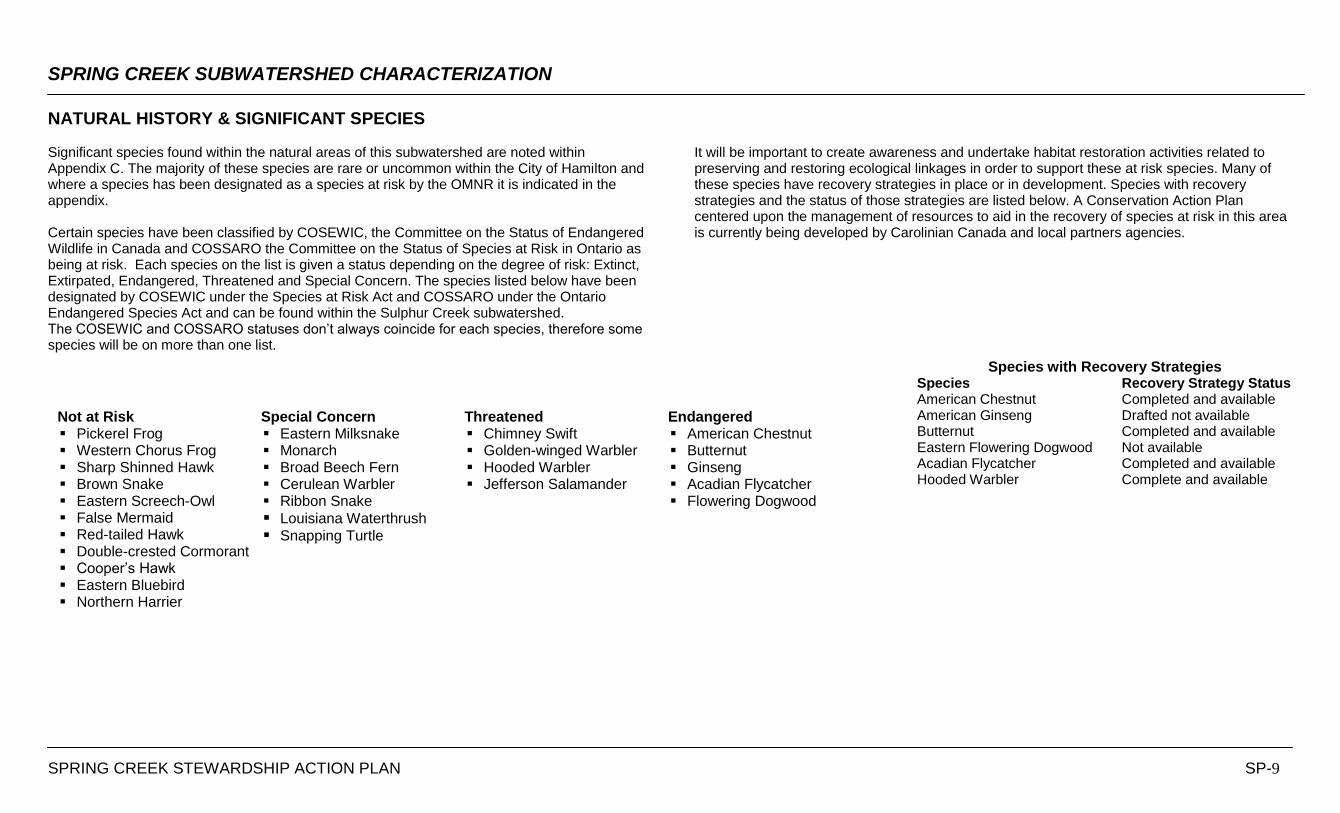
NATURAL HISTORY & SIGNIFICANT SPECIES Significant species found within the natural areas of this subwatershed are noted within Appendix C. The majority of these species are rare or uncommon within the City of Hamilton and where a species has been designated as a species at risk by the OMNR it is indicated in the appendix. Certain species have been classified by COSEWIC, the Committee on the Status of Endangered Wildlife in Canada and COSSARO the Committee on the Status of Species at Risk in Ontario as being at risk. Each species on the list is given a status depending on the degree of risk: Extinct, Extirpated, Endangered, Threatened and Special Concern. The species listed below have been designated by COSEWIC under the Species at Risk Act and COSSARO under the Ontario Endangered Species Act and can be found within the Sulphur Creek subwatershed. The COSEWIC and COSSARO statuses don‟t always coincide for each species, therefore some species will be on more than one list.
It will be important to create awareness and undertake habitat restoration activities related to preserving and restoring ecological linkages in order to support these at risk species. Many of these species have recovery strategies in place or in development. Species with recovery strategies and the status of those strategies are listed below. A Conservation Action Plan centered upon the management of resources to aid in the recovery of species at risk in this area is currently being developed by Carolinian Canada and local partners agencies.
Species with Recovery Strategies Species Recovery Strategy Status American Chestnut Completed and available American Ginseng Drafted not available Butternut Completed and available Eastern Flowering Dogwood Not available Acadian Flycatcher Completed and available Hooded Warbler Complete and available
Not at Risk Pickerel Frog Western Chorus Frog Sharp Shinned Hawk Brown Snake Eastern Screech-Owl False Mermaid Red-tailed Hawk Double-crested Cormorant Cooper‟s Hawk Eastern Bluebird Northern Harrier
Special Concern Eastern Milksnake Monarch Broad Beech Fern Cerulean Warbler Ribbon Snake
Louisiana Waterthrush Snapping Turtle
Threatened Chimney Swift Golden-winged Warbler Hooded Warbler Jefferson Salamander
Endangered American Chestnut Butternut Ginseng Acadian Flycatcher Flowering Dogwood
SPRING CREEK STEWARDSHIP ACTION PLAN SP-10
Base Mapping supplied by the City of Hamilton, and the Ministry of Natural Resources. © 2010 Queen’s Printer for Ontario, City of Hamilton and Teranet Land Information
Services Inc. and its licensors. May not be reproduced without permission. All information provided is believed to be accurate and reliable. We will make changes,
updates and deletions as required and make every effort to ensure the accuracy and quality of the information provided. However, the Hamilton Conservation Authority assumes no responsibility for any errors or omissions and is not liable for any damages
of any kind resulting from the use of, or reliance on, the information contained herein.
SPRING CREEK SUBWATERSHED CHARACTERIZATION
SPRING CREEK STEWARDSHIP ACTION PLAN SP-11
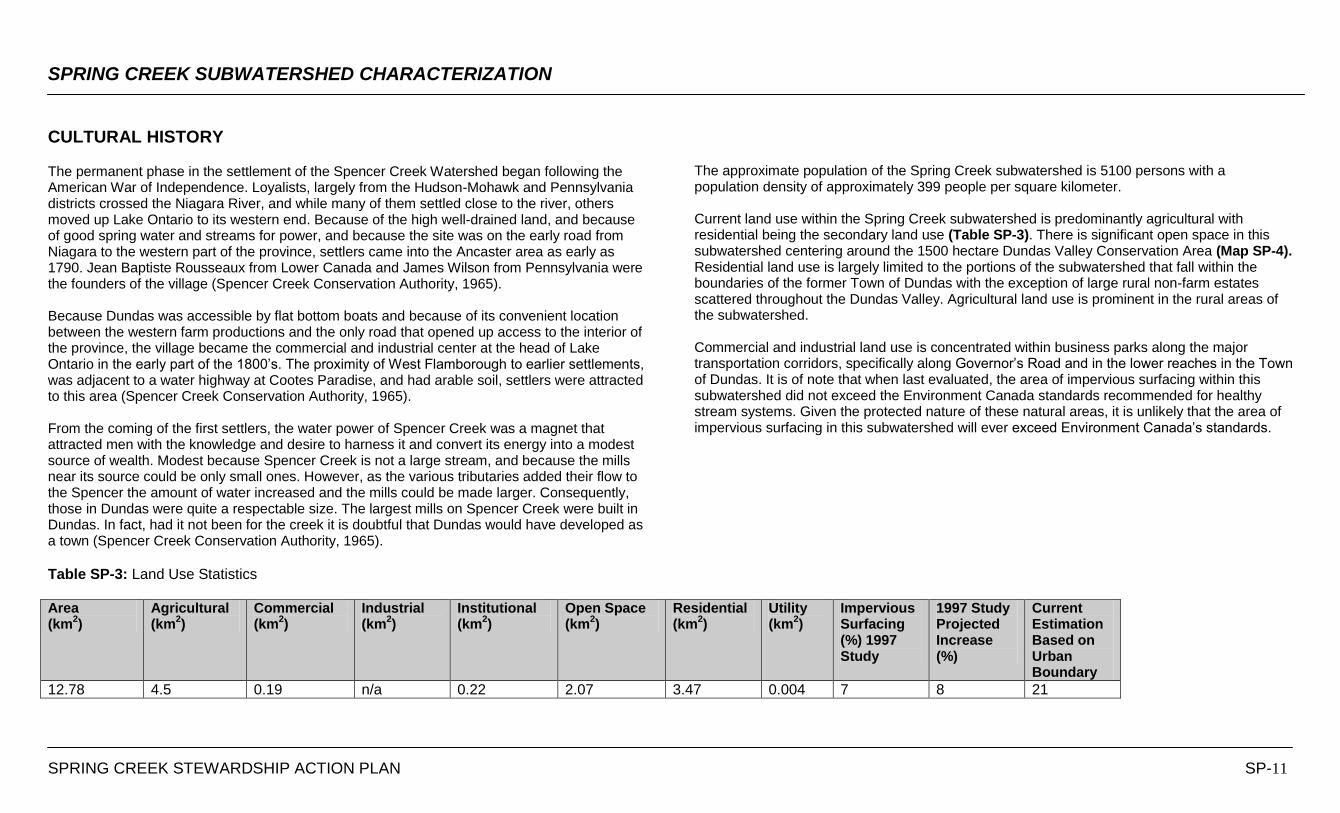
CULTURAL HISTORY The permanent phase in the settlement of the Spencer Creek Watershed began following the American War of Independence. Loyalists, largely from the Hudson-Mohawk and Pennsylvania districts crossed the Niagara River, and while many of them settled close to the river, others moved up Lake Ontario to its western end. Because of the high well-drained land, and because of good spring water and streams for power, and because the site was on the early road from Niagara to the western part of the province, settlers came into the Ancaster area as early as 1790. Jean Baptiste Rousseaux from Lower Canada and James Wilson from Pennsylvania were the founders of the village (Spencer Creek Conservation Authority, 1965). Because Dundas was accessible by flat bottom boats and because of its convenient location between the western farm productions and the only road that opened up access to the interior of the province, the village became the commercial and industrial center at the head of Lake Ontario in the early part of the 1800‟s. The proximity of West Flamborough to earlier settlements, was adjacent to a water highway at Cootes Paradise, and had arable soil, settlers were attracted to this area (Spencer Creek Conservation Authority, 1965). From the coming of the first settlers, the water power of Spencer Creek was a magnet that attracted men with the knowledge and desire to harness it and convert its energy into a modest source of wealth. Modest because Spencer Creek is not a large stream, and because the mills near its source could be only small ones. However, as the various tributaries added their flow to the Spencer the amount of water increased and the mills could be made larger. Consequently, those in Dundas were quite a respectable size. The largest mills on Spencer Creek were built in Dundas. In fact, had it not been for the creek it is doubtful that Dundas would have developed as a town (Spencer Creek Conservation Authority, 1965).
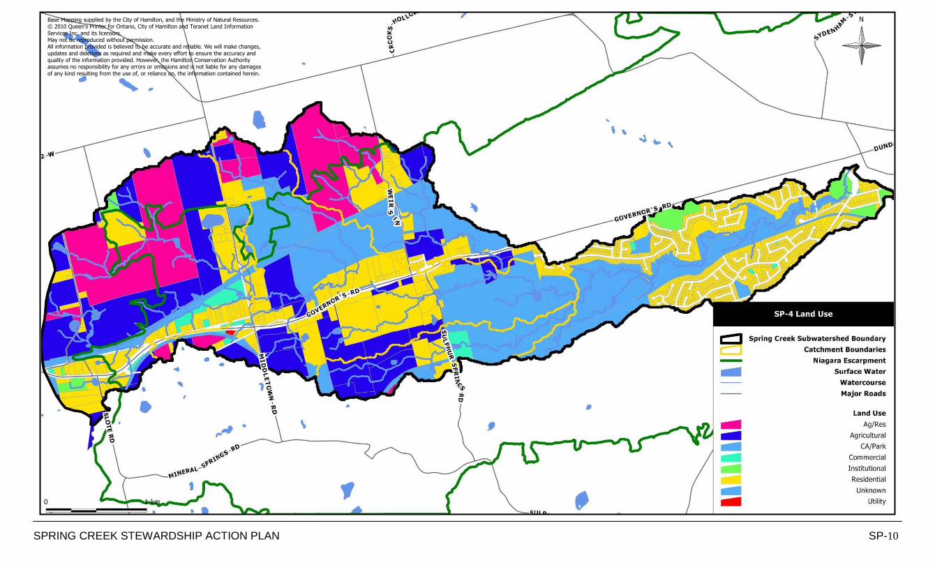
The approximate population of the Spring Creek subwatershed is 5100 persons with a population density of approximately 399 people per square kilometer. Current land use within the Spring Creek subwatershed is predominantly agricultural with residential being the secondary land use (Table SP-3). There is significant open space in this subwatershed centering around the 1500 hectare Dundas Valley Conservation Area (Map SP-4). Residential land use is largely limited to the portions of the subwatershed that fall within the boundaries of the former Town of Dundas with the exception of large rural non-farm estates scattered throughout the Dundas Valley. Agricultural land use is prominent in the rural areas of the subwatershed. Commercial and industrial land use is concentrated within business parks along the major transportation corridors, specifically along Governor‟s Road and in the lower reaches in the Town of Dundas. It is of note that when last evaluated, the area of impervious surfacing within this subwatershed did not exceed the Environment Canada standards recommended for healthy stream systems. Given the protected nature of these natural areas, it is unlikely that the area of impervious surfacing in this subwatershed will ever exceed Environment Canada‟s standards.
Table SP-3: Land Use Statistics Area (km
2)
Agricultural (km
2)
Commercial (km
2)
Industrial (km
2)
Institutional (km
2)
Open Space (km
2)
Residential (km
2)
Utility (km
2)
Impervious Surfacing (%) 1997 Study
1997 Study Projected Increase (%)
Current Estimation Based on Urban Boundary
12.78 4.5 0.19 n/a 0.22 2.07 3.47 0.004 7 8 21
SPRING CREEK STEWARDSHIP ACTION PLAN SP-12
Base Mapping supplied by the City of Hamilton, and the Ministry of Natural Resources.
© 2010 Queen’s Printer for Ontario, City of Hamilton and Teranet Land Information Services Inc. and its licensors. May not be reproduced without permission.
All information provided is believed to be accurate and reliable. We will make changes, updates and deletions as required and make every effort to ensure the accuracy and
quality of the information provided. However, the Hamilton Conservation Authority assumes no responsibility for any errors or omissions and is not liable for any damages of any kind resulting from the use of, or reliance on, the information contained herein.
SPRING CREEK SUBWATERSHED CHARACTERIZATION
SPRING CREEK STEWARDSHIP ACTION PLAN SP-13
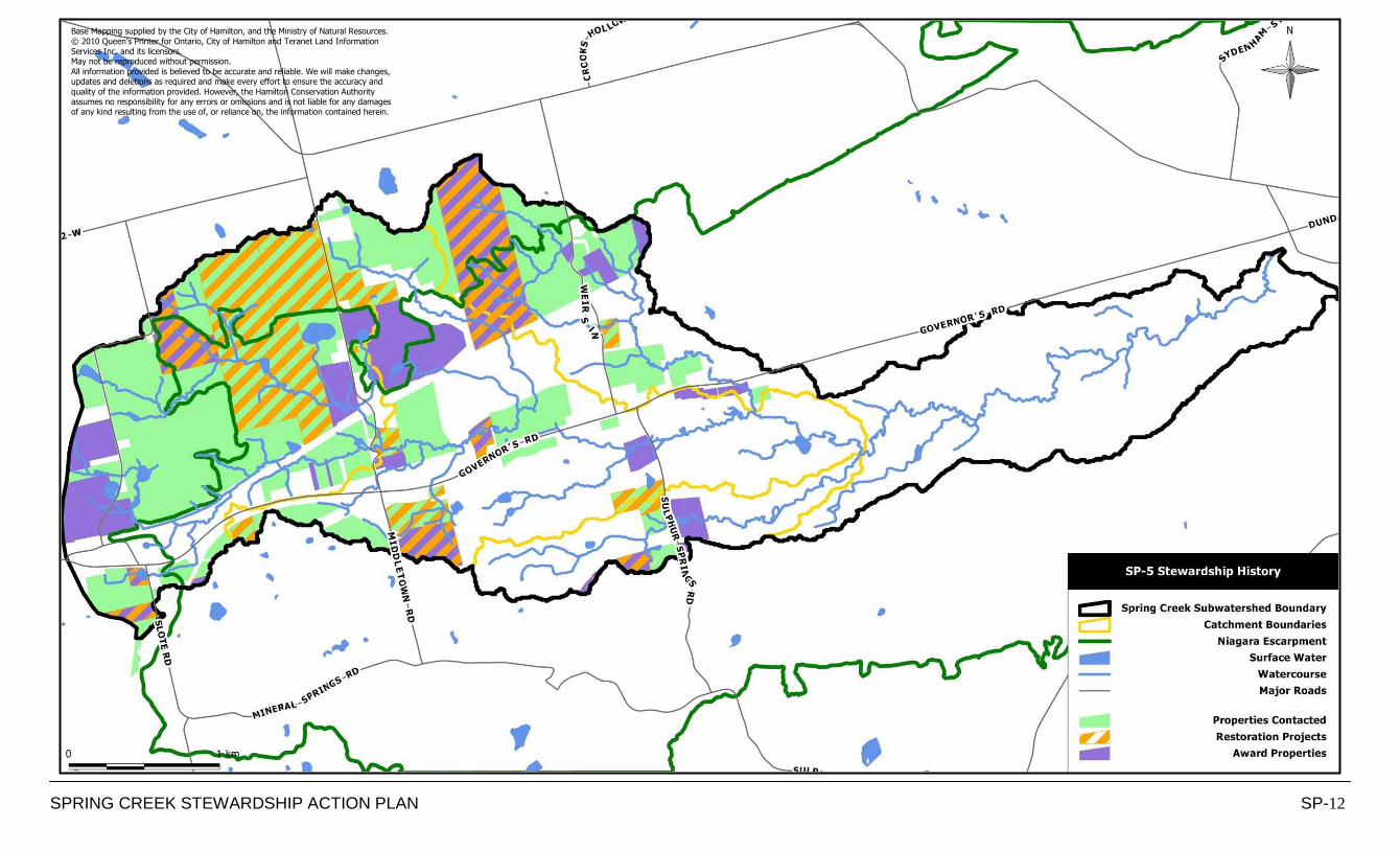
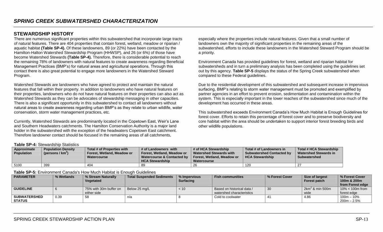
STEWARDSHIP HISTORYThere are numerous significant properties within this subwatershed that incorporate large tracts of natural features. There are 404 properties that contain forest, wetland, meadow or riparian / aquatic habitat (Table SP-4). Of these landowners, 89 (or 22%) have been contacted by the Hamilton-Halton Watershed Stewardship Program (HHWSP), and 26 (or 6%) of those have become Watershed Stewards (Table SP-4). Therefore, there is considerable potential to reach the remaining 78% of landowners with natural features to create awareness regarding Beneficial Management Practices (BMP‟s) for natural areas and agricultural operations. Through this contact there is also great potential to engage more landowners in the Watershed Steward Program. Watershed Stewards are landowners who have agreed to protect and maintain the natural features that fall within their property. In addition to landowners who have natural features on their properties, landowners who do not have natural features on their properties can also act as Watershed Stewards as they can be advocates of stewardship messaging in other capacities. There is also a significant opportunity in this subwatershed to contact all landowners without natural areas to create awareness regarding urban BMP‟s as they relate to urban wildlife, water conservation, storm water management practices, etc. Currently, Watershed Stewards are predominantly located in the Copetown East, Weir‟s Lane and Southern Headwaters catchments. The Hamilton Conservation Authority is a major land holder in the subwatershed with the exception of the headwaters Copetown East catchment. Therefore landowner contact should be focused in the remaining areas of all catchments,
especially where the properties include natural features. Given that a small number of landowners own the majority of significant properties in the remaining areas of the subwatershed, efforts to include these landowners in the Watershed Steward Program should be a priority. Environment Canada has provided guidelines for forest, wetland and riparian habitat for subwatersheds and in turn a preliminary analysis has been completed using the guidelines set out by this agency. Table SP-5 displays the status of the Spring Creek subwatershed when compared to these Federal guidelines. Due to the residential development of this subwatershed and subsequent increase in impervious surfacing, BMP‟s relating to storm water management must be promoted and exemplified by partner agencies in an effort to prevent erosion, sedimentation and contamination within the system. This is especially important in the lower reaches of the subwatershed since much of the development has occurred in these areas. This subwatershed exceeds Environment Canada‟s How Much Habitat is Enough Guidelines for forest cover. Efforts to retain this percentage of forest cover and to preserve biodiversity and core habitat within the area should be undertaken to support interior forest breeding birds and
other wildlife populations.
Table SP-4: Stewardship Statistics Approximate Population
Population Density (persons / km
2)
Total # of Properties with Forest, Wetland, Meadow or Watercourse
# of Landowners with Forest, Wetland, Meadow or Watercourse & Contacted by HCA Stewardship
# of HCA Stewardship Watershed Stewards with Forest, Wetland, Meadow or Watercourse
Total # of Landowners in Subwatershed Contacted by HCA Stewardship
Total # HCA Stewardship Watershed Stewards in Subwatershed
5100 399 404 89 26 120 27
Table SP-5: Environment Canada's How Much Habitat is Enough Guidelines PARAMETER % Wetlands % Stream Naturally
Vegetated Total Suspended Sediments % Impervious
Surfacing Fish communities % Forest Cover Size of largest
Forest patch % Forest Cover 100m & 200m from Forest edge
GUIDELINE 6 75% with 30m buffer on either side
Below 25 mg/L < 10 Based on historical data / watershed characteristics
30 2km2 & min 500m
wide 10% < 100m from forest edge
SUBWATERSHED STATUS
0.39 58 n/a 8 Cold to coolwater 41 4.86 100m – 10% 200m – 2.5%
STRESSES & STEWARDSHIP ACTIONS
SPRING CREEK STEWARDSHIP ACTION PLAN SP-14
There are thirty six types of stresses identified as negatively impacting the Spring Creek subwatershed. An inventory count of the number of each type of stress observed in each catchment basin of the subwatershed is listed in Table SP- 7. The most prevalent stresses identified in the Spring Creek Subwatershed are Stormsewer Outfalls, Abandoned Groundwater Wells, On-line Ponds and Increased Impervious Surfaciing. Table SP-8 outlines Stewardship Actions that have been developed to mitigate the impacts of these and the remaining stresses listed in Table SP-7. Specific locations where these stresses are occurring are mapped and inventoried in the subsequent catchment datasheets. Within the Spring Creek subwatershed, 60 specific locations where stresses are occurring have been identified; however, this inventory is not exhaustive and therefore implementation of Stewardship Actions should be undertaken on a subwatershed scale to ensure that all occurrences of stresses are mitigated. In summary, stormwater management in the urbanized catchments of this subwatershed is of primary concern. Stormwater management relates directly to the health of the local fishery as it increases the potential for erosion and contamination in the creek system. The Bay Area Restoration Council offers the Yellow Fish Road program in an effort to raise awareness about stormsewer systems and the potential for stormwater runoff contamination. An effort to implement the recommendations in the City of Hamilton Stormwater Master Plan should be made to mitigate the impacts of stormwater on the creek system. Abandoned groundwater wells are direct conduits to groundwater aquifers and have the potential to introduce contaminates into the groundwater supply. Derelict well caps and casing are also safety hazards to people and wildlife. Efforts to promote the City of Hamilton Well Decommissioning Program should be taken. Anecdotal reports and ecological monitoring have identified sediment loading and subsequent nutrient loading as a concern in this subwatershed. The Hamilton-Harbour Remedial Action Plan 2009 draft document, Identifying Non Point Sediment Sources, identifies two sites of active erosion; one on the east side of Weir‟s Lane and the other on the north side of Governor‟s Road; for priority remediation; both are on private property. It is believed that the former is caused by alterations that have been made to the creek channel to accommodate an adjacent pond. The latter is believed to be the result of a massive failure of the creek back, intense scouring and sedimentation upstream. Assessments of stormwater impacts on these sites and remediation plans for these sites should be developed by the Spencer Creek Stewardship Action Plans Implementation Team.
Habitat Fragmentation has been identified in two locations within this subwatershed. Strategic acquisitions and management of lands in these area can enhance core habitat and ecological function in this the Spring Creek system. The Cootes to Escarpment Park System and Dundas Valley 50 Year Vision documents both recommend actions to preserve and enhance ecological connectivity in this area. The Spencer Creek Stewardship Action Plans Implementation Team should support and assist with the implementation of recommendations in these documents. There are numerous on-line ponds and dams in this subwatershed which fragment aquatic habitat by creating physical and thermal barriers to migration. Aquatic wildlife are unable to negotiate these barriers and therefore restoration is necessary to open up additional habitat upstream. Removal or retrofit of pond retention structures or the installation of by-pass channels and fish ladders are recommended mitigation concepts. According to the City of Hamilton Draft Stages of Development Plan for 2010-2012, Dundas, there is only one significant pending development application in this subwatershed; the first phase of the Grandview Estates development at Governor‟s Road and Pirie Drive. This subwatershed is experiencing an ecosystem imbalance. A survey conducted by the Hamilton Conservation Authority and the Ministry of Natural Resources in 2007 has identified an overpopulation of white-tailed deer in this area. Evidence of excessive browsing inhibiting regeneration of woodland flora triggered the conservation authority to undertake a deer exclosure pilot project in 2008; the results of the exclosure experiment further supports the survey findings by demonstrating that the area is beyond its carrying capacity for this species. The Hamilton Conservation Authority is currently working with the Ministry of Natural Resources to develop regionally specific management strategies for this situation, guided by the MNR Strategy for Preventing and Managing Human-Deer Conflicts in Southern Ontario document which was developed through a multi stakeholder facilitated process to ensure that all sector groups interests were considered.
Local residents have voiced concerns regarding wildlife disturbances and water quality degradation resulting from pet waste in the Warren Park area of this subwatershed. Warren Park is a municipally owned park located between two Hamilton Conservation Authority properties and is currently a leash-free area for dogs. A petition has been put forward requesting that the City re-designate the park as a leash-required area citing the fact that the park is within an Environmentally Significant Area which is contrary to City policy regarding the designation of leash-free areas. Staff from the City and Hamilton Conservation Authority are working together to develop and put forward recommendations regarding this petition in an effort to remediate the current degradation and to prevent further stresses from impacting the significant natural features within the park.
CATCHMENT SUMMARIES
SPRING CREEK STEWARDSHIP ACTION PLAN SP-15
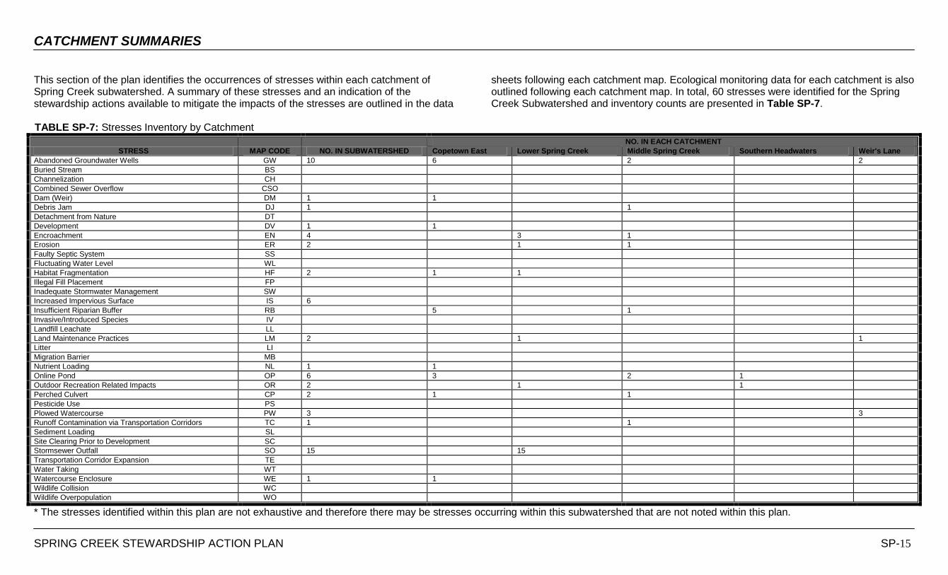
This section of the plan identifies the occurrences of stresses within each catchment of Spring Creek subwatershed. A summary of these stresses and an indication of the stewardship actions available to mitigate the impacts of the stresses are outlined in the data
sheets following each catchment map. Ecological monitoring data for each catchment is also outlined following each catchment map. In total, 60 stresses were identified for the Spring Creek Subwatershed and inventory counts are presented in Table SP-7.
TABLE SP-7: Stresses Inventory by Catchment
STRESS MAP CODE NO. IN SUBWATERSHED
NO. IN EACH CATCHMENT
Copetown East Lower Spring Creek Middle Spring Creek Southern Headwaters Weir's Lane
Abandoned Groundwater Wells GW 10 6 2 2
Buried Stream BS
Channelization CH
Combined Sewer Overflow CSO
Dam (Weir) DM 1 1
Debris Jam DJ 1 1
Detachment from Nature DT
Development DV 1 1
Encroachment EN 4 3 1
Erosion ER 2 1 1
Faulty Septic System SS
Fluctuating Water Level WL
Habitat Fragmentation HF 2 1 1
Illegal Fill Placement FP
Inadequate Stormwater Management SW
Increased Impervious Surface IS 6
Insufficient Riparian Buffer RB 5 1
Invasive/Introduced Species IV
Landfill Leachate LL
Land Maintenance Practices LM 2 1 1
Litter LI
Migration Barrier MB
Nutrient Loading NL 1 1
Online Pond OP 6 3 2 1
Outdoor Recreation Related Impacts OR 2 1 1
Perched Culvert CP 2 1 1
Pesticide Use PS
Plowed Watercourse PW 3 3
Runoff Contamination via Transportation Corridors TC 1 1
Sediment Loading SL
Site Clearing Prior to Development SC
Stormsewer Outfall SO 15 15
Transportation Corridor Expansion TE
Water Taking WT
Watercourse Enclosure WE 1 1
Wildlife Collision WC
Wildlife Overpopulation WO
* The stresses identified within this plan are not exhaustive and therefore there may be stresses occurring within this subwatershed that are not noted within this plan.
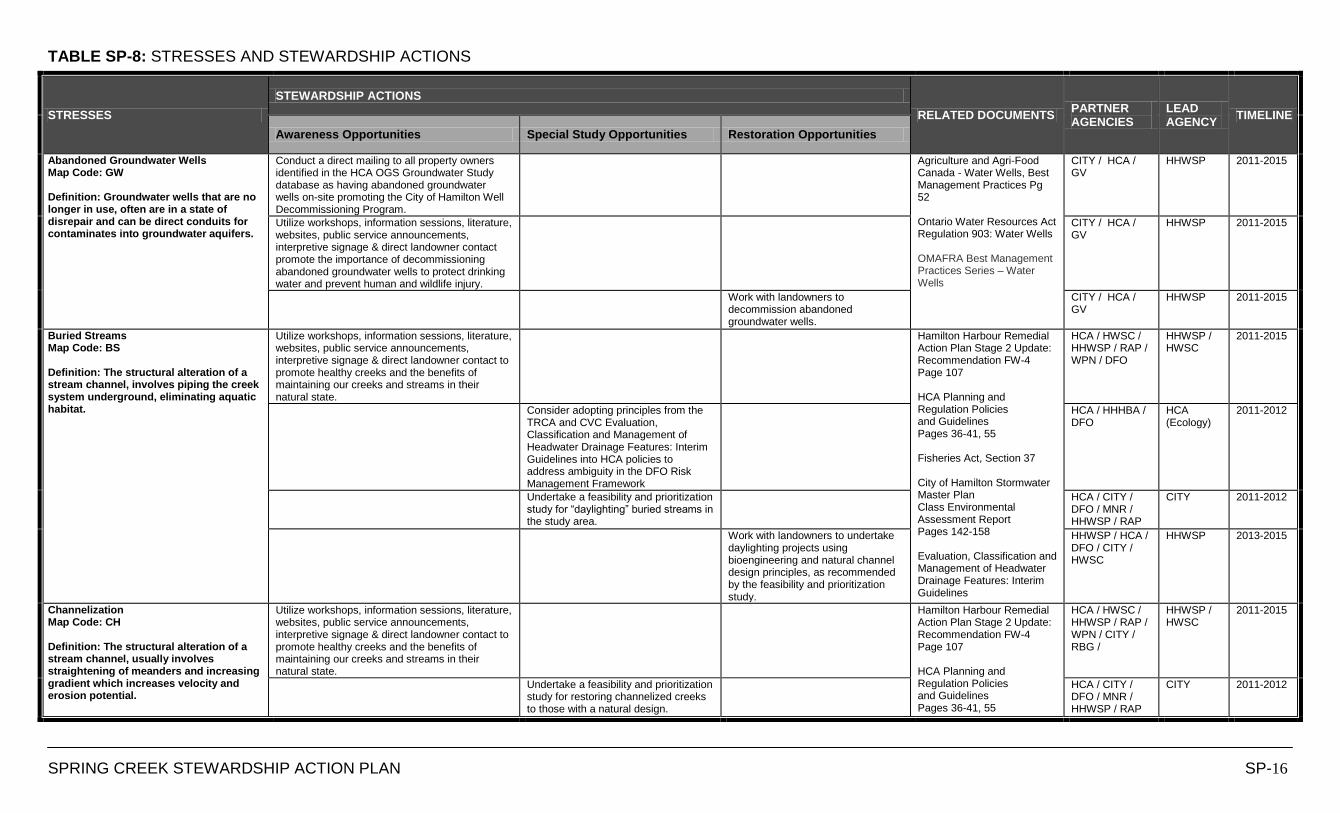
TABLE SP-8: STRESSES AND STEWARDSHIP ACTIONS
SPRING CREEK STEWARDSHIP ACTION PLAN SP-16
STRESSES
STEWARDSHIP ACTIONS
RELATED DOCUMENTS PARTNER AGENCIES
LEAD AGENCY
TIMELINE
Awareness Opportunities Special Study Opportunities Restoration Opportunities
Abandoned Groundwater Wells Map Code: GW Definition: Groundwater wells that are no longer in use, often are in a state of disrepair and can be direct conduits for contaminates into groundwater aquifers.
Conduct a direct mailing to all property owners identified in the HCA OGS Groundwater Study database as having abandoned groundwater wells on-site promoting the City of Hamilton Well Decommissioning Program.
Agriculture and Agri-Food Canada - Water Wells, Best Management Practices Pg 52 Ontario Water Resources Act Regulation 903: Water Wells OMAFRA Best Management Practices Series – Water Wells
CITY / HCA / GV
HHWSP 2011-2015
Utilize workshops, information sessions, literature, websites, public service announcements, interpretive signage & direct landowner contact promote the importance of decommissioning abandoned groundwater wells to protect drinking water and prevent human and wildlife injury.
CITY / HCA / GV
HHWSP 2011-2015
Work with landowners to decommission abandoned groundwater wells.
CITY / HCA / GV
HHWSP 2011-2015
Buried Streams Map Code: BS Definition: The structural alteration of a stream channel, involves piping the creek system underground, eliminating aquatic habitat.
Utilize workshops, information sessions, literature, websites, public service announcements, interpretive signage & direct landowner contact to promote healthy creeks and the benefits of maintaining our creeks and streams in their natural state.
Hamilton Harbour Remedial Action Plan Stage 2 Update: Recommendation FW-4 Page 107 HCA Planning and Regulation Policies and Guidelines Pages 36-41, 55 Fisheries Act, Section 37 City of Hamilton Stormwater Master Plan Class Environmental Assessment Report Pages 142-158 Evaluation, Classification and Management of Headwater Drainage Features: Interim Guidelines
HCA / HWSC / HHWSP / RAP / WPN / DFO
HHWSP / HWSC
2011-2015
Consider adopting principles from the TRCA and CVC Evaluation, Classification and Management of Headwater Drainage Features: Interim Guidelines into HCA policies to address ambiguity in the DFO Risk Management Framework
HCA / HHHBA / DFO
HCA (Ecology)
2011-2012
Undertake a feasibility and prioritization study for “daylighting” buried streams in the study area.
HCA / CITY / DFO / MNR / HHWSP / RAP
CITY 2011-2012
Work with landowners to undertake daylighting projects using bioengineering and natural channel design principles, as recommended by the feasibility and prioritization study.
HHWSP / HCA / DFO / CITY / HWSC
HHWSP 2013-2015
Channelization Map Code: CH Definition: The structural alteration of a stream channel, usually involves straightening of meanders and increasing gradient which increases velocity and erosion potential.
Utilize workshops, information sessions, literature, websites, public service announcements, interpretive signage & direct landowner contact to promote healthy creeks and the benefits of maintaining our creeks and streams in their natural state.
Hamilton Harbour Remedial Action Plan Stage 2 Update: Recommendation FW-4 Page 107 HCA Planning and Regulation Policies and Guidelines Pages 36-41, 55
HCA / HWSC / HHWSP / RAP / WPN / CITY / RBG /
HHWSP / HWSC
2011-2015
Undertake a feasibility and prioritization study for restoring channelized creeks to those with a natural design.
HCA / CITY / DFO / MNR / HHWSP / RAP
CITY 2011-2012
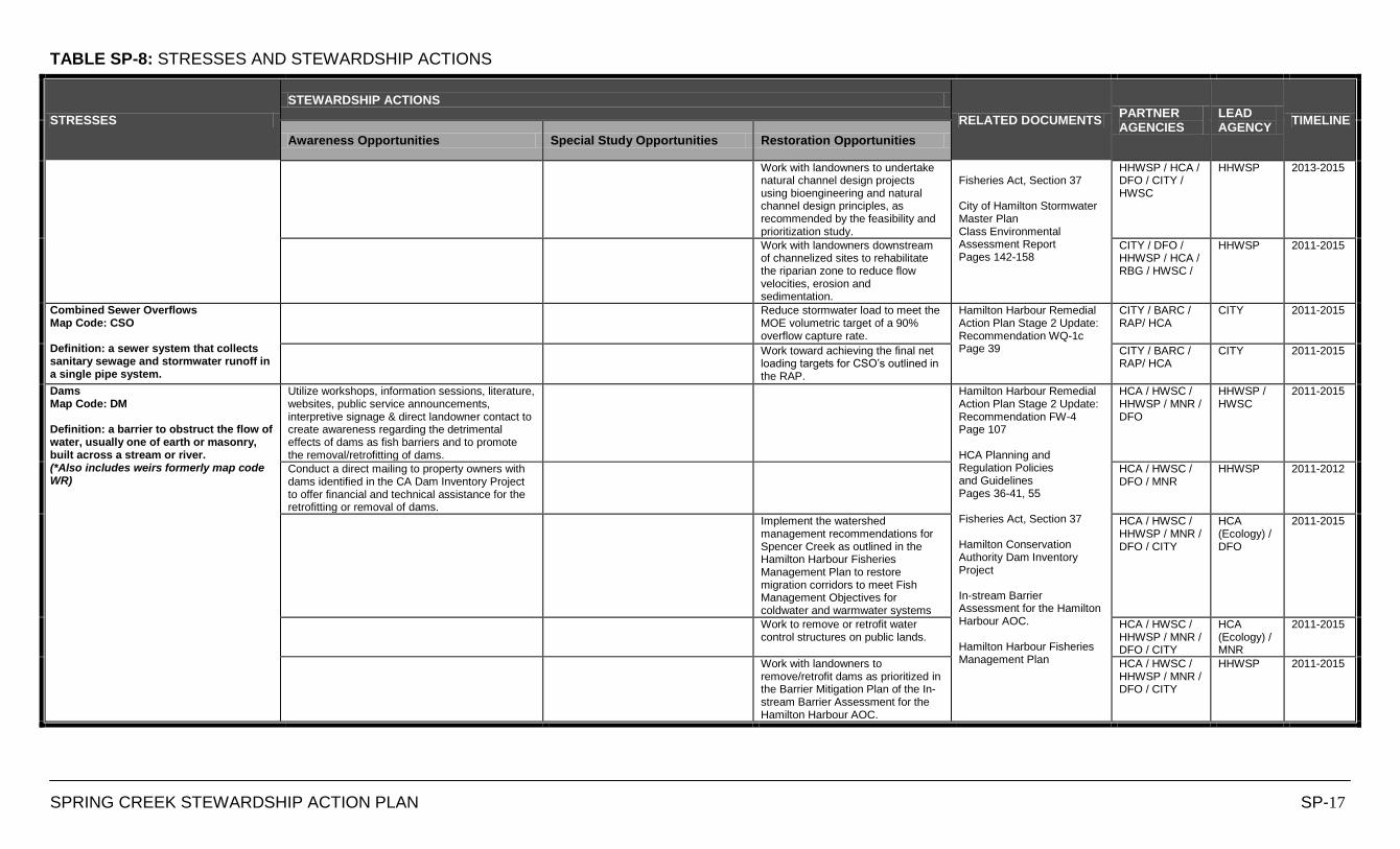
TABLE SP-8: STRESSES AND STEWARDSHIP ACTIONS
SPRING CREEK STEWARDSHIP ACTION PLAN SP-17
STRESSES
STEWARDSHIP ACTIONS
RELATED DOCUMENTS PARTNER AGENCIES
LEAD AGENCY
TIMELINE
Awareness Opportunities Special Study Opportunities Restoration Opportunities
Work with landowners to undertake natural channel design projects using bioengineering and natural channel design principles, as recommended by the feasibility and prioritization study.
Fisheries Act, Section 37 City of Hamilton Stormwater Master Plan Class Environmental Assessment Report Pages 142-158
HHWSP / HCA / DFO / CITY / HWSC
HHWSP 2013-2015
Work with landowners downstream of channelized sites to rehabilitate the riparian zone to reduce flow velocities, erosion and sedimentation.
CITY / DFO / HHWSP / HCA / RBG / HWSC /
HHWSP 2011-2015
Combined Sewer Overflows Map Code: CSO Definition: a sewer system that collects sanitary sewage and stormwater runoff in a single pipe system.
Reduce stormwater load to meet the MOE volumetric target of a 90% overflow capture rate.
Hamilton Harbour Remedial Action Plan Stage 2 Update: Recommendation WQ-1c Page 39
CITY / BARC / RAP/ HCA
CITY 2011-2015
Work toward achieving the final net loading targets for CSO‟s outlined in the RAP.
CITY / BARC / RAP/ HCA
CITY 2011-2015
Dams Map Code: DM Definition: a barrier to obstruct the flow of water, usually one of earth or masonry, built across a stream or river. (*Also includes weirs formerly map code WR)
Utilize workshops, information sessions, literature, websites, public service announcements, interpretive signage & direct landowner contact to create awareness regarding the detrimental effects of dams as fish barriers and to promote the removal/retrofitting of dams.
Hamilton Harbour Remedial Action Plan Stage 2 Update: Recommendation FW-4 Page 107 HCA Planning and Regulation Policies and Guidelines Pages 36-41, 55 Fisheries Act, Section 37 Hamilton Conservation Authority Dam Inventory Project In-stream Barrier Assessment for the Hamilton Harbour AOC. Hamilton Harbour Fisheries Management Plan
HCA / HWSC / HHWSP / MNR / DFO
HHWSP / HWSC
2011-2015
Conduct a direct mailing to property owners with dams identified in the CA Dam Inventory Project to offer financial and technical assistance for the retrofitting or removal of dams.
HCA / HWSC / DFO / MNR
HHWSP 2011-2012
Implement the watershed management recommendations for Spencer Creek as outlined in the Hamilton Harbour Fisheries Management Plan to restore migration corridors to meet Fish Management Objectives for coldwater and warmwater systems
HCA / HWSC / HHWSP / MNR / DFO / CITY
HCA (Ecology) / DFO
2011-2015
Work to remove or retrofit water control structures on public lands.
HCA / HWSC / HHWSP / MNR / DFO / CITY
HCA (Ecology) / MNR
2011-2015
Work with landowners to remove/retrofit dams as prioritized in the Barrier Mitigation Plan of the In-stream Barrier Assessment for the Hamilton Harbour AOC.
HCA / HWSC / HHWSP / MNR / DFO / CITY
HHWSP 2011-2015
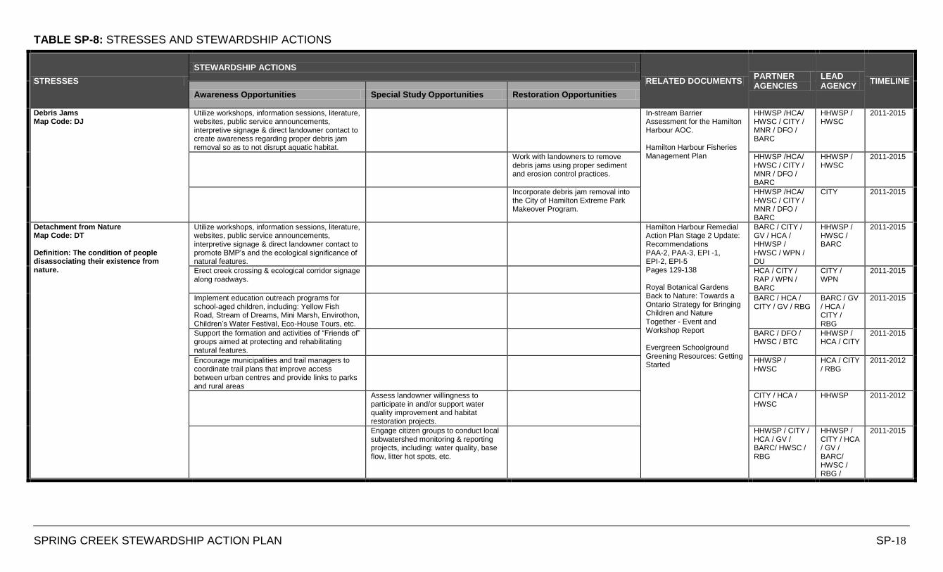
TABLE SP-8: STRESSES AND STEWARDSHIP ACTIONS
SPRING CREEK STEWARDSHIP ACTION PLAN SP-18
STRESSES
STEWARDSHIP ACTIONS
RELATED DOCUMENTS PARTNER AGENCIES
LEAD AGENCY
TIMELINE
Awareness Opportunities Special Study Opportunities Restoration Opportunities
Debris Jams Map Code: DJ
Utilize workshops, information sessions, literature, websites, public service announcements, interpretive signage & direct landowner contact to create awareness regarding proper debris jam removal so as to not disrupt aquatic habitat.
In-stream Barrier Assessment for the Hamilton Harbour AOC. Hamilton Harbour Fisheries Management Plan
HHWSP /HCA/ HWSC / CITY / MNR / DFO / BARC
HHWSP / HWSC
2011-2015
Work with landowners to remove debris jams using proper sediment and erosion control practices.
HHWSP /HCA/ HWSC / CITY / MNR / DFO / BARC
HHWSP / HWSC
2011-2015
Incorporate debris jam removal into the City of Hamilton Extreme Park Makeover Program.
HHWSP /HCA/ HWSC / CITY / MNR / DFO / BARC
CITY 2011-2015
Detachment from Nature Map Code: DT Definition: The condition of people disassociating their existence from nature.
Utilize workshops, information sessions, literature, websites, public service announcements, interpretive signage & direct landowner contact to promote BMP‟s and the ecological significance of natural features.
Hamilton Harbour Remedial Action Plan Stage 2 Update: Recommendations PAA-2, PAA-3, EPI -1, EPI-2, EPI-5 Pages 129-138 Royal Botanical Gardens Back to Nature: Towards a Ontario Strategy for Bringing Children and Nature Together - Event and Workshop Report Evergreen Schoolground Greening Resources: Getting Started
BARC / CITY / GV / HCA / HHWSP / HWSC / WPN / DU
HHWSP / HWSC / BARC
2011-2015
Erect creek crossing & ecological corridor signage along roadways.
HCA / CITY / RAP / WPN / BARC
CITY / WPN
2011-2015
Implement education outreach programs for school-aged children, including: Yellow Fish Road, Stream of Dreams, Mini Marsh, Envirothon, Children‟s Water Festival, Eco-House Tours, etc.
BARC / HCA / CITY / GV / RBG
BARC / GV / HCA / CITY / RBG
2011-2015
Support the formation and activities of “Friends of” groups aimed at protecting and rehabilitating natural features.
BARC / DFO / HWSC / BTC
HHWSP / HCA / CITY
2011-2015
Encourage municipalities and trail managers to coordinate trail plans that improve access between urban centres and provide links to parks and rural areas
HHWSP / HWSC
HCA / CITY / RBG
2011-2012
Assess landowner willingness to participate in and/or support water quality improvement and habitat restoration projects.
CITY / HCA / HWSC
HHWSP 2011-2012
Engage citizen groups to conduct local subwatershed monitoring & reporting projects, including: water quality, base flow, litter hot spots, etc.
HHWSP / CITY / HCA / GV / BARC/ HWSC / RBG
HHWSP / CITY / HCA / GV / BARC/ HWSC / RBG /
2011-2015
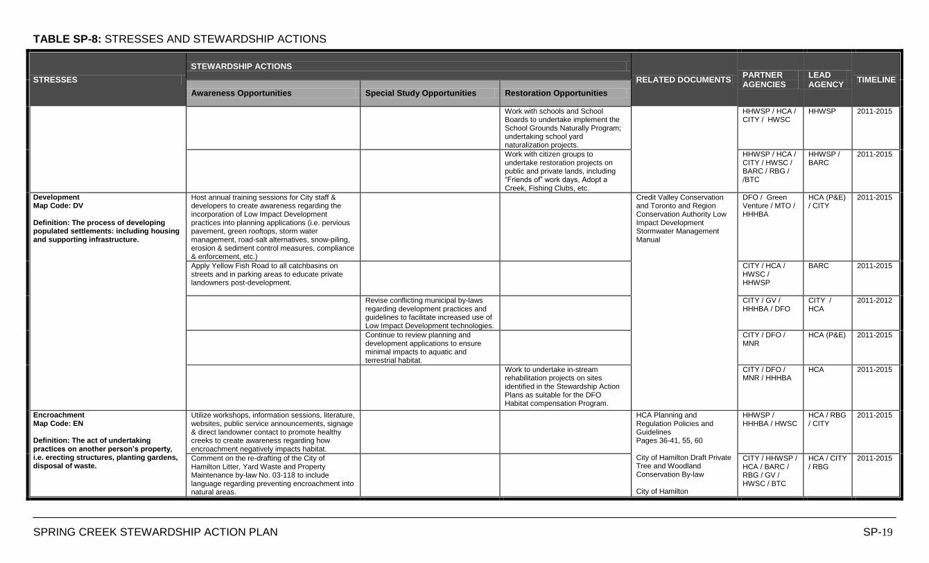
TABLE SP-8: STRESSES AND STEWARDSHIP ACTIONS
SPRING CREEK STEWARDSHIP ACTION PLAN SP-19
STRESSES
STEWARDSHIP ACTIONS
RELATED DOCUMENTS PARTNER AGENCIES
LEAD AGENCY
TIMELINE
Awareness Opportunities Special Study Opportunities Restoration Opportunities
Work with schools and School Boards to undertake implement the School Grounds Naturally Program; undertaking school yard naturalization projects.
HHWSP / HCA / CITY / HWSC
HHWSP 2011-2015
Work with citizen groups to undertake restoration projects on public and private lands, including “Friends of” work days, Adopt a Creek, Fishing Clubs, etc.
HHWSP / HCA / CITY / HWSC / BARC / RBG / /BTC
HHWSP / BARC
2011-2015
Development Map Code: DV Definition: The process of developing populated settlements: including housing and supporting infrastructure.
Host annual training sessions for City staff & developers to create awareness regarding the incorporation of Low Impact Development practices into planning applications (i.e. pervious pavement, green rooftops, storm water management, road-salt alternatives, snow-piling, erosion & sediment control measures, compliance & enforcement, etc.)
Credit Valley Conservation and Toronto and Region Conservation Authority Low Impact Development Stormwater Management Manual
DFO / Green Venture / MTO / HHHBA
HCA (P&E) / CITY
2011-2015
Apply Yellow Fish Road to all catchbasins on streets and in parking areas to educate private landowners post-development.
CITY / HCA / HWSC / HHWSP
BARC 2011-2015
Revise conflicting municipal by-laws regarding development practices and guidelines to facilitate increased use of Low Impact Development technologies.
CITY / GV / HHHBA / DFO
CITY / HCA
2011-2012
Continue to review planning and development applications to ensure minimal impacts to aquatic and terrestrial habitat.
CITY / DFO / MNR
HCA (P&E) 2011-2015
Work to undertake in-stream rehabilitation projects on sites identified in the Stewardship Action Plans as suitable for the DFO Habitat compensation Program.
CITY / DFO / MNR / HHHBA
HCA 2011-2015
Encroachment Map Code: EN Definition: The act of undertaking practices on another person’s property, i.e. erecting structures, planting gardens, disposal of waste.
Utilize workshops, information sessions, literature, websites, public service announcements, signage & direct landowner contact to promote healthy creeks to create awareness regarding how encroachment negatively impacts habitat.
HCA Planning and Regulation Policies and Guidelines Pages 36-41, 55, 60 City of Hamilton Draft Private Tree and Woodland Conservation By-law City of Hamilton
HHWSP / HHHBA / HWSC
HCA / RBG / CITY
2011-2015
Comment on the re-drafting of the City of Hamilton Litter, Yard Waste and Property Maintenance by-law No. 03-118 to include language regarding preventing encroachment into natural areas.
CITY / HHWSP / HCA / BARC / RBG / GV / HWSC / BTC
HCA / CITY / RBG
2011-2015
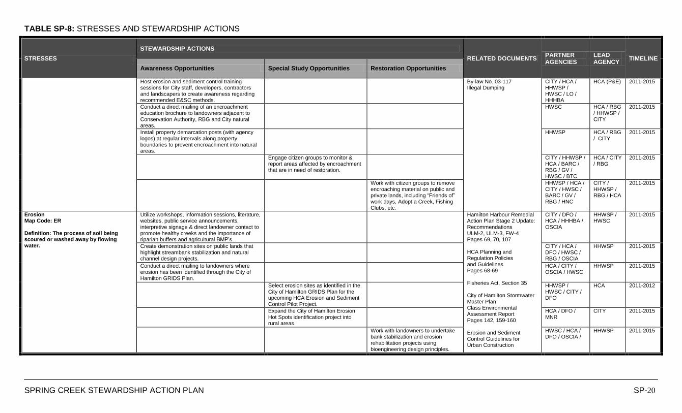
TABLE SP-8: STRESSES AND STEWARDSHIP ACTIONS
SPRING CREEK STEWARDSHIP ACTION PLAN SP-20
STRESSES
STEWARDSHIP ACTIONS
RELATED DOCUMENTS PARTNER AGENCIES
LEAD AGENCY
TIMELINE
Awareness Opportunities Special Study Opportunities Restoration Opportunities
Host erosion and sediment control training sessions for City staff, developers, contractors and landscapers to create awareness regarding recommended E&SC methods.
By-law No. 03-117 Illegal Dumping
CITY / HCA / HHWSP / HWSC / LO / HHHBA
HCA (P&E) 2011-2015
Conduct a direct mailing of an encroachment education brochure to landowners adjacent to Conservation Authority, RBG and City natural areas.
HWSC HCA / RBG / HHWSP / CITY
2011-2015
Install property demarcation posts (with agency logos) at regular intervals along property boundaries to prevent encroachment into natural areas.
HHWSP HCA / RBG / CITY
2011-2015
Engage citizen groups to monitor & report areas affected by encroachment that are in need of restoration.
CITY / HHWSP / HCA / BARC / RBG / GV / HWSC / BTC
HCA / CITY / RBG
2011-2015
Work with citizen groups to remove encroaching material on public and private lands, including “Friends of” work days, Adopt a Creek, Fishing Clubs, etc.
HHWSP / HCA / CITY / HWSC / BARC / GV / RBG / HNC
CITY / HHWSP / RBG / HCA
2011-2015
Erosion Map Code: ER Definition: The process of soil being scoured or washed away by flowing water.
Utilize workshops, information sessions, literature, websites, public service announcements, interpretive signage & direct landowner contact to promote healthy creeks and the importance of riparian buffers and agricultural BMP‟s.
Hamilton Harbour Remedial Action Plan Stage 2 Update: Recommendations ULM-2, ULM-3, FW-4 Pages 69, 70, 107 HCA Planning and Regulation Policies and Guidelines Pages 68-69 Fisheries Act, Section 35 City of Hamilton Stormwater Master Plan Class Environmental Assessment Report Pages 142, 159-160 Erosion and Sediment Control Guidelines for Urban Construction
CITY / DFO / HCA / HHHBA / OSCIA
HHWSP / HWSC
2011-2015
Create demonstration sites on public lands that highlight streambank stabilization and natural channel design projects.
CITY / HCA / DFO / HWSC / RBG / OSCIA
HHWSP 2011-2015
Conduct a direct mailing to landowners where erosion has been identified through the City of Hamilton GRIDS Plan.
HCA / CITY / OSCIA / HWSC
HHWSP 2011-2015
Select erosion sites as identified in the City of Hamilton GRIDS Plan for the upcoming HCA Erosion and Sediment Control Pilot Project.
HHWSP / HWSC / CITY / DFO
HCA 2011-2012
Expand the City of Hamilton Erosion Hot Spots identification project into rural areas
HCA / DFO / MNR
CITY 2011-2015
Work with landowners to undertake bank stabilization and erosion rehabilitation projects using bioengineering design principles.
HWSC / HCA / DFO / OSCIA /
HHWSP 2011-2015
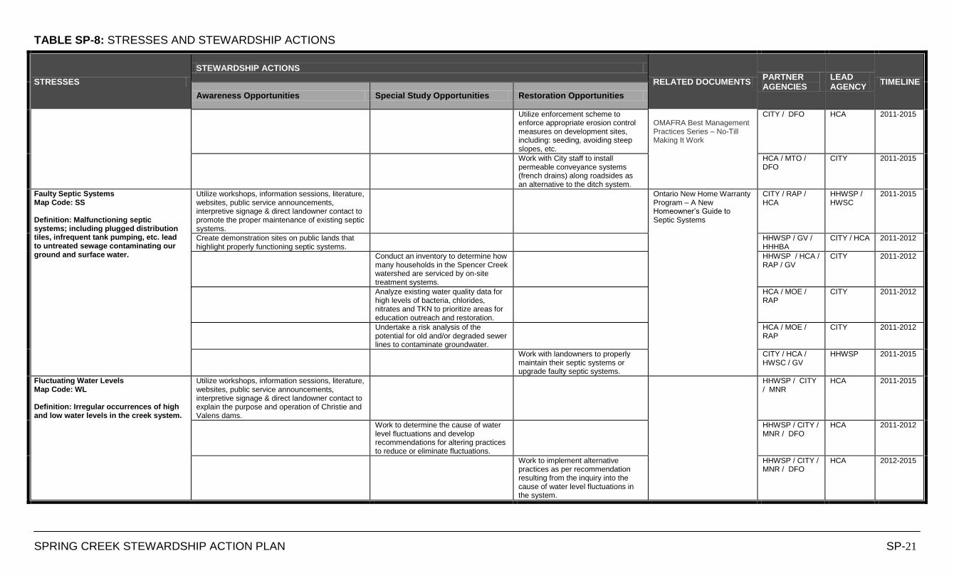
TABLE SP-8: STRESSES AND STEWARDSHIP ACTIONS
SPRING CREEK STEWARDSHIP ACTION PLAN SP-21
STRESSES
STEWARDSHIP ACTIONS
RELATED DOCUMENTS PARTNER AGENCIES
LEAD AGENCY
TIMELINE
Awareness Opportunities Special Study Opportunities Restoration Opportunities
Utilize enforcement scheme to enforce appropriate erosion control measures on development sites, including: seeding, avoiding steep slopes, etc.
OMAFRA Best Management Practices Series – No-Till Making It Work
CITY / DFO HCA 2011-2015
Work with City staff to install permeable conveyance systems (french drains) along roadsides as an alternative to the ditch system.
HCA / MTO / DFO
CITY 2011-2015
Faulty Septic Systems Map Code: SS Definition: Malfunctioning septic systems; including plugged distribution tiles, infrequent tank pumping, etc. lead to untreated sewage contaminating our ground and surface water.
Utilize workshops, information sessions, literature, websites, public service announcements, interpretive signage & direct landowner contact to promote the proper maintenance of existing septic systems.
Ontario New Home Warranty Program – A New Homeowner‟s Guide to Septic Systems
CITY / RAP / HCA
HHWSP / HWSC
2011-2015
Create demonstration sites on public lands that highlight properly functioning septic systems.
HHWSP / GV / HHHBA
CITY / HCA 2011-2012
Conduct an inventory to determine how many households in the Spencer Creek watershed are serviced by on-site treatment systems.
HHWSP / HCA / RAP / GV
CITY 2011-2012
Analyze existing water quality data for high levels of bacteria, chlorides, nitrates and TKN to prioritize areas for education outreach and restoration.
HCA / MOE / RAP
CITY 2011-2012
Undertake a risk analysis of the potential for old and/or degraded sewer lines to contaminate groundwater.
HCA / MOE / RAP
CITY 2011-2012
Work with landowners to properly maintain their septic systems or upgrade faulty septic systems.
CITY / HCA / HWSC / GV
HHWSP 2011-2015
Fluctuating Water Levels Map Code: WL Definition: Irregular occurrences of high and low water levels in the creek system.
Utilize workshops, information sessions, literature, websites, public service announcements, interpretive signage & direct landowner contact to explain the purpose and operation of Christie and Valens dams.
HHWSP / CITY / MNR
HCA 2011-2015
Work to determine the cause of water level fluctuations and develop recommendations for altering practices to reduce or eliminate fluctuations.
HHWSP / CITY / MNR / DFO
HCA 2011-2012
Work to implement alternative practices as per recommendation resulting from the inquiry into the cause of water level fluctuations in the system.
HHWSP / CITY / MNR / DFO
HCA 2012-2015
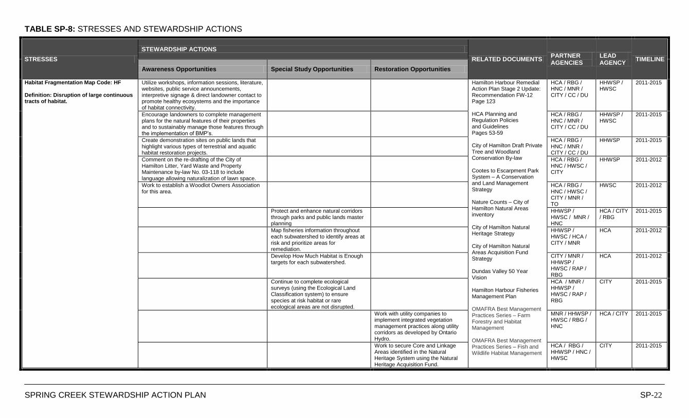
TABLE SP-8: STRESSES AND STEWARDSHIP ACTIONS
SPRING CREEK STEWARDSHIP ACTION PLAN SP-22
STRESSES
STEWARDSHIP ACTIONS
RELATED DOCUMENTS PARTNER AGENCIES
LEAD AGENCY
TIMELINE
Awareness Opportunities Special Study Opportunities Restoration Opportunities
Habitat Fragmentation Map Code: HF Definition: Disruption of large continuous tracts of habitat.
Utilize workshops, information sessions, literature, websites, public service announcements, interpretive signage & direct landowner contact to promote healthy ecosystems and the importance of habitat connectivity.
Hamilton Harbour Remedial Action Plan Stage 2 Update: Recommendation FW-12 Page 123 HCA Planning and Regulation Policies and Guidelines Pages 53-59 City of Hamilton Draft Private Tree and Woodland Conservation By-law Cootes to Escarpment Park System – A Conservation and Land Management Strategy Nature Counts – City of Hamilton Natural Areas inventory City of Hamilton Natural Heritage Strategy City of Hamilton Natural Areas Acquisition Fund Strategy Dundas Valley 50 Year Vision Hamilton Harbour Fisheries Management Plan OMAFRA Best Management Practices Series – Farm Forestry and Habitat Management OMAFRA Best Management Practices Series – Fish and Wildlife Habitat Management
HCA / RBG / HNC / MNR / CITY / CC / DU
HHWSP / HWSC
2011-2015
Encourage landowners to complete management plans for the natural features of their properties and to sustainably manage those features through the implementation of BMP‟s.
HCA / RBG / HNC / MNR / CITY / CC / DU
HHWSP / HWSC
2011-2015
Create demonstration sites on public lands that highlight various types of terrestrial and aquatic habitat restoration projects.
HCA / RBG / HNC / MNR / CITY / CC / DU
HHWSP 2011-2015
Comment on the re-drafting of the City of Hamilton Litter, Yard Waste and Property Maintenance by-law No. 03-118 to include language allowing naturalization of lawn space.
HCA / RBG / HNC / HWSC / CITY
HHWSP 2011-2012
Work to establish a Woodlot Owners Association for this area.
HCA / RBG / HNC / HWSC / CITY / MNR / TO
HWSC 2011-2012
Protect and enhance natural corridors through parks and public lands master planning
HHWSP / HWSC / MNR / HNC
HCA / CITY / RBG
2011-2015
Map fisheries information throughout each subwatershed to identify areas at risk and prioritize areas for remediation.
HHWSP / HWSC / HCA / CITY / MNR
HCA 2011-2012
Develop How Much Habitat is Enough targets for each subwatershed.
CITY / MNR / HHWSP / HWSC / RAP / RBG
HCA 2011-2012
Continue to complete ecological surveys (using the Ecological Land Classification system) to ensure species at risk habitat or rare ecological areas are not disrupted.
HCA / MNR / HHWSP / HWSC / RAP / RBG
CITY 2011-2015
Work with utility companies to implement integrated vegetation management practices along utility corridors as developed by Ontario Hydro.
MNR / HHWSP / HWSC / RBG / HNC
HCA / CITY 2011-2015
Work to secure Core and Linkage Areas identified in the Natural Heritage System using the Natural Heritage Acquisition Fund.
HCA / RBG / HHWSP / HNC / HWSC
CITY 2011-2015
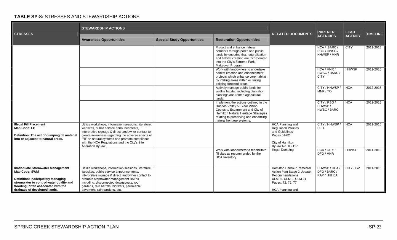
TABLE SP-8: STRESSES AND STEWARDSHIP ACTIONS
SPRING CREEK STEWARDSHIP ACTION PLAN SP-23
STRESSES
STEWARDSHIP ACTIONS
RELATED DOCUMENTS PARTNER AGENCIES
LEAD AGENCY
TIMELINE
Awareness Opportunities Special Study Opportunities Restoration Opportunities
Protect and enhance natural corridors through parks and public lands by ensuring that naturalization and habitat creation are incorporated into the City‟s Extreme Park Makeover Program
HCA / BARC / RBG / HWSC / HHWSP / MNR
CITY 2011-2015
Work with landowners to undertake habitat creation and enhancement projects which enhance core habitat by infilling areas within or linking existing forested areas
HCA / MNR / HWSC / BARC / CITY
HHWSP 2011-2015
Actively manage public lands for wildlife habitat, including plantation plantings and rented agricultural lands.
CITY / HHWSP / MNR / TO
HCA 2012-2015
Implement the actions outlined in the Dundas Valley 50 Year Vision, Cootes to Escarpment and City of Hamilton Natural Heritage Strategies relating to preserving and enhancing natural heritage systems.
CITY / RBG / HHWSP / HWSC / BARC
HCA 2011-2015
Illegal Fill Placement Map Code: FP Definition: The act of dumping fill material into or adjacent to natural areas.
Utilize workshops, information sessions, literature, websites, public service announcements, interpretive signage & direct landowner contact to create awareness regarding the adverse effects of “fill” on natural systems and promote compliance with the HCA Regulations and the City‟s Site Alteration By-law.
HCA Planning and Regulation Policies and Guidelines Pages 61-62 City of Hamilton By-law No. 03-117 Illegal Dumping
CITY / HHWSP / DFO
HCA 2011-2015
Work with landowners to rehabilitate fill sites as recommended by the HCA Inventory.
HCA / CITY / DFO / MNR
HHWSP 2011-2015
Inadequate Stormwater Management Map Code: SWM Definition: Inadequately managing stormwater to control water quality and flooding; often associated with the drainage of developed lands.
Utilize workshops, information sessions, literature, websites, public service announcements, interpretive signage & direct landowner contact to promote stormwater management BMP‟s including: disconnected downspouts, roof gardens, rain barrels, biofilters, permeable pavement, rain gardens, etc.
Hamilton Harbour Remedial Action Plan Stage 2 Update: Recommendations ULM -6, ULM-9, ULM-11 Pages, 72, 75, 77 HCA Planning and
HHWSP / HCA / DFO / BARC / RAP / HHHBA
CITY / GV 2011-2015
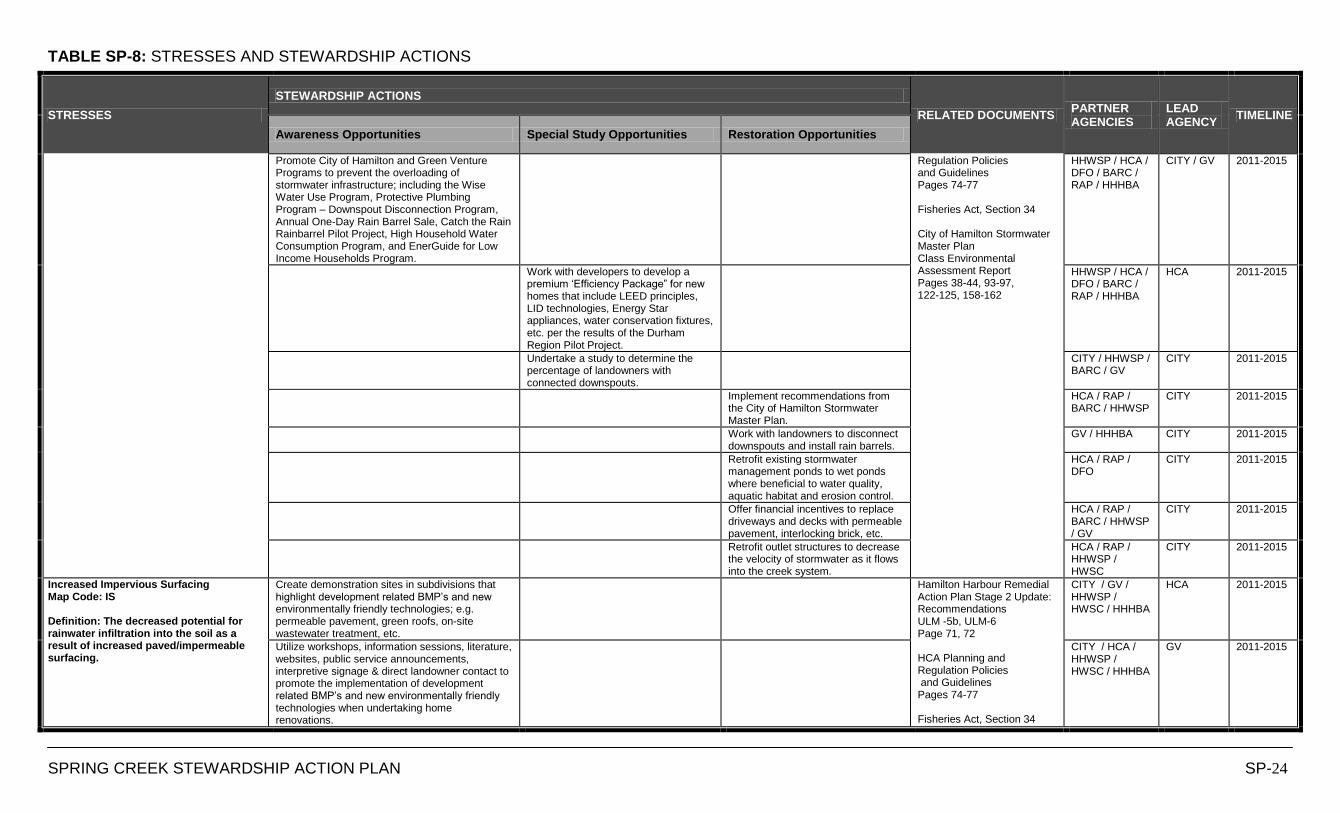
TABLE SP-8: STRESSES AND STEWARDSHIP ACTIONS
SPRING CREEK STEWARDSHIP ACTION PLAN SP-24
STRESSES
STEWARDSHIP ACTIONS
RELATED DOCUMENTS PARTNER AGENCIES
LEAD AGENCY
TIMELINE
Awareness Opportunities Special Study Opportunities Restoration Opportunities
Promote City of Hamilton and Green Venture Programs to prevent the overloading of stormwater infrastructure; including the Wise Water Use Program, Protective Plumbing Program – Downspout Disconnection Program, Annual One-Day Rain Barrel Sale, Catch the Rain Rainbarrel Pilot Project, High Household Water Consumption Program, and EnerGuide for Low Income Households Program.
Regulation Policies and Guidelines Pages 74-77 Fisheries Act, Section 34 City of Hamilton Stormwater Master Plan Class Environmental Assessment Report Pages 38-44, 93-97, 122-125, 158-162
HHWSP / HCA / DFO / BARC / RAP / HHHBA
CITY / GV 2011-2015
Work with developers to develop a premium „Efficiency Package” for new homes that include LEED principles, LID technologies, Energy Star appliances, water conservation fixtures, etc. per the results of the Durham Region Pilot Project.
HHWSP / HCA / DFO / BARC / RAP / HHHBA
HCA 2011-2015
Undertake a study to determine the percentage of landowners with connected downspouts.
CITY / HHWSP / BARC / GV
CITY 2011-2015
Implement recommendations from the City of Hamilton Stormwater Master Plan.
HCA / RAP / BARC / HHWSP
CITY 2011-2015
Work with landowners to disconnect downspouts and install rain barrels.
GV / HHHBA CITY 2011-2015
Retrofit existing stormwater management ponds to wet ponds where beneficial to water quality, aquatic habitat and erosion control.
HCA / RAP / DFO
CITY 2011-2015
Offer financial incentives to replace driveways and decks with permeable pavement, interlocking brick, etc.
HCA / RAP / BARC / HHWSP / GV
CITY 2011-2015
Retrofit outlet structures to decrease the velocity of stormwater as it flows into the creek system.
HCA / RAP / HHWSP / HWSC
CITY 2011-2015
Increased Impervious Surfacing Map Code: IS Definition: The decreased potential for rainwater infiltration into the soil as a result of increased paved/impermeable surfacing.
Create demonstration sites in subdivisions that highlight development related BMP‟s and new environmentally friendly technologies; e.g. permeable pavement, green roofs, on-site wastewater treatment, etc.
Hamilton Harbour Remedial Action Plan Stage 2 Update: Recommendations ULM -5b, ULM-6 Page 71, 72 HCA Planning and Regulation Policies and Guidelines Pages 74-77 Fisheries Act, Section 34
CITY / GV / HHWSP / HWSC / HHHBA
HCA 2011-2015
Utilize workshops, information sessions, literature, websites, public service announcements, interpretive signage & direct landowner contact to promote the implementation of development related BMP‟s and new environmentally friendly technologies when undertaking home renovations.
CITY / HCA / HHWSP / HWSC / HHHBA
GV 2011-2015
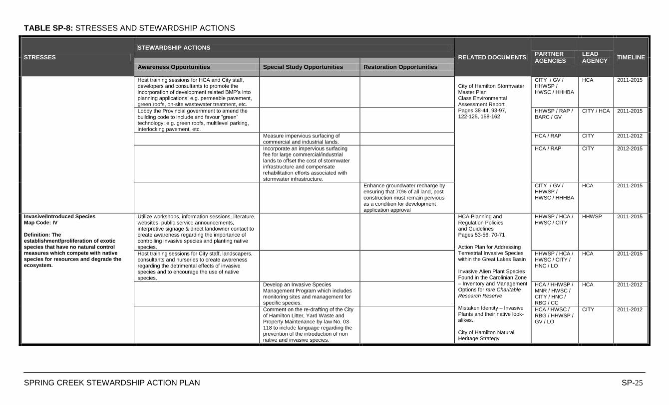
TABLE SP-8: STRESSES AND STEWARDSHIP ACTIONS
SPRING CREEK STEWARDSHIP ACTION PLAN SP-25
STRESSES
STEWARDSHIP ACTIONS
RELATED DOCUMENTS PARTNER AGENCIES
LEAD AGENCY
TIMELINE
Awareness Opportunities Special Study Opportunities Restoration Opportunities
Host training sessions for HCA and City staff, developers and consultants to promote the incorporation of development related BMP‟s into planning applications; e.g. permeable pavement, green roofs, on-site wastewater treatment, etc.
City of Hamilton Stormwater Master Plan Class Environmental Assessment Report Pages 38-44, 93-97, 122-125, 158-162
CITY / GV / HHWSP / HWSC / HHHBA
HCA 2011-2015
Lobby the Provincial government to amend the building code to include and favour “green” technology; e.g. green roofs, multilevel parking, interlocking pavement, etc.
HHWSP / RAP / BARC / GV
CITY / HCA 2011-2015
Measure impervious surfacing of commercial and industrial lands.
HCA / RAP CITY 2011-2012
Incorporate an impervious surfacing fee for large commercial/industrial lands to offset the cost of stormwater infrastructure and compensate rehabilitation efforts associated with stormwater infrastructure.
HCA / RAP CITY 2012-2015
Enhance groundwater recharge by ensuring that 70% of all land, post construction must remain pervious as a condition for development application approval
CITY / GV / HHWSP / HWSC / HHHBA
HCA 2011-2015
Invasive/Introduced Species Map Code: IV Definition: The establishment/proliferation of exotic species that have no natural control measures which compete with native species for resources and degrade the ecosystem.
Utilize workshops, information sessions, literature, websites, public service announcements, interpretive signage & direct landowner contact to create awareness regarding the importance of controlling invasive species and planting native species.
HCA Planning and Regulation Policies and Guidelines Pages 53-56, 70-71 Action Plan for Addressing Terrestrial Invasive Species within the Great Lakes Basin Invasive Alien Plant Species Found in the Carolinian Zone – Inventory and Management Options for rare Charitable Research Reserve Mistaken Identity – Invasive Plants and their native look-alikes. City of Hamilton Natural Heritage Strategy
HHWSP / HCA / HWSC / CITY
HHWSP 2011-2015
Host training sessions for City staff, landscapers, consultants and nurseries to create awareness regarding the detrimental effects of invasive species and to encourage the use of native species.
HHWSP / HCA / HWSC / CITY / HNC / LO
HCA 2011-2015
Develop an Invasive Species Management Program which includes monitoring sites and management for specific species.
HCA / HHWSP / MNR / HWSC / CITY / HNC / RBG / CC
HCA 2011-2012
Comment on the re-drafting of the City of Hamilton Litter, Yard Waste and Property Maintenance by-law No. 03-118 to include language regarding the prevention of the introduction of non native and invasive species.
HCA / HWSC / RBG / HHWSP / GV / LO
CITY 2011-2012
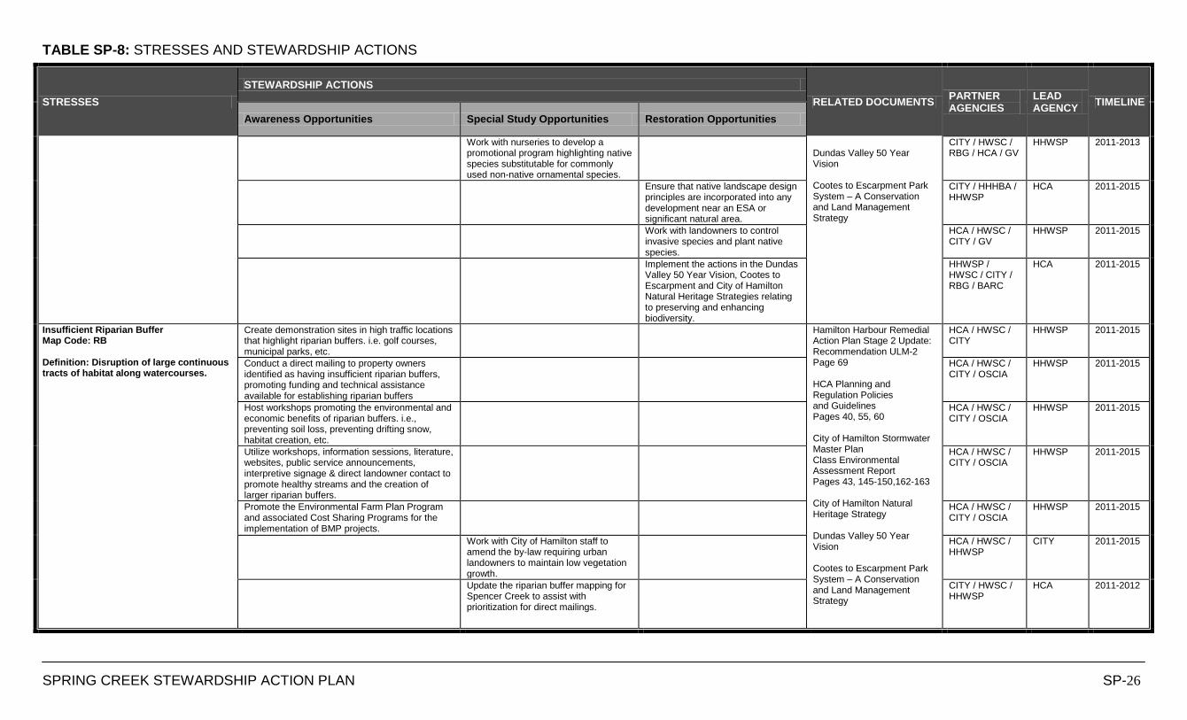
TABLE SP-8: STRESSES AND STEWARDSHIP ACTIONS
SPRING CREEK STEWARDSHIP ACTION PLAN SP-26
STRESSES
STEWARDSHIP ACTIONS
RELATED DOCUMENTS PARTNER AGENCIES
LEAD AGENCY
TIMELINE
Awareness Opportunities Special Study Opportunities Restoration Opportunities
Work with nurseries to develop a promotional program highlighting native species substitutable for commonly used non-native ornamental species.
Dundas Valley 50 Year Vision Cootes to Escarpment Park System – A Conservation and Land Management Strategy
CITY / HWSC / RBG / HCA / GV
HHWSP 2011-2013
Ensure that native landscape design principles are incorporated into any development near an ESA or significant natural area.
CITY / HHHBA / HHWSP
HCA 2011-2015
Work with landowners to control invasive species and plant native species.
HCA / HWSC / CITY / GV
HHWSP 2011-2015
Implement the actions in the Dundas Valley 50 Year Vision, Cootes to Escarpment and City of Hamilton Natural Heritage Strategies relating to preserving and enhancing biodiversity.
HHWSP / HWSC / CITY / RBG / BARC
HCA 2011-2015
Insufficient Riparian Buffer Map Code: RB Definition: Disruption of large continuous tracts of habitat along watercourses.
Create demonstration sites in high traffic locations that highlight riparian buffers. i.e. golf courses, municipal parks, etc.
Hamilton Harbour Remedial Action Plan Stage 2 Update: Recommendation ULM-2 Page 69 HCA Planning and Regulation Policies and Guidelines Pages 40, 55, 60 City of Hamilton Stormwater Master Plan Class Environmental Assessment Report Pages 43, 145-150,162-163 City of Hamilton Natural Heritage Strategy Dundas Valley 50 Year Vision Cootes to Escarpment Park System – A Conservation and Land Management Strategy
HCA / HWSC / CITY
HHWSP 2011-2015
Conduct a direct mailing to property owners identified as having insufficient riparian buffers, promoting funding and technical assistance available for establishing riparian buffers
HCA / HWSC / CITY / OSCIA
HHWSP 2011-2015
Host workshops promoting the environmental and economic benefits of riparian buffers. i.e., preventing soil loss, preventing drifting snow, habitat creation, etc.
HCA / HWSC / CITY / OSCIA
HHWSP 2011-2015
Utilize workshops, information sessions, literature, websites, public service announcements, interpretive signage & direct landowner contact to promote healthy streams and the creation of larger riparian buffers.
HCA / HWSC / CITY / OSCIA
HHWSP 2011-2015
Promote the Environmental Farm Plan Program and associated Cost Sharing Programs for the implementation of BMP projects.
HCA / HWSC / CITY / OSCIA
HHWSP 2011-2015
Work with City of Hamilton staff to amend the by-law requiring urban landowners to maintain low vegetation growth.
HCA / HWSC / HHWSP
CITY 2011-2015
Update the riparian buffer mapping for Spencer Creek to assist with prioritization for direct mailings.
CITY / HWSC / HHWSP
HCA 2011-2012
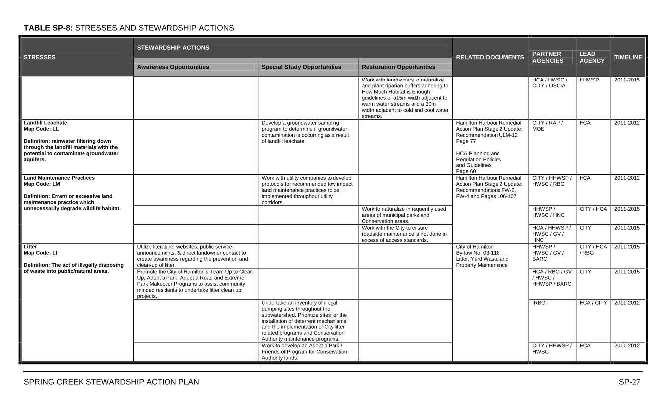
TABLE SP-8: STRESSES AND STEWARDSHIP ACTIONS
SPRING CREEK STEWARDSHIP ACTION PLAN SP-27
STRESSES
STEWARDSHIP ACTIONS
RELATED DOCUMENTS PARTNER AGENCIES
LEAD AGENCY
TIMELINE
Awareness Opportunities Special Study Opportunities Restoration Opportunities
Work with landowners to naturalize and plant riparian buffers adhering to How Much Habitat is Enough guidelines of a15m width adjacent to warm water streams and a 30m width adjacent to cold and cool water streams.
HCA / HWSC / CITY / OSCIA
HHWSP 2011-2015
Landfill Leachate Map Code: LL Definition: rainwater filtering down through the landfill materials with the potential to contaminate groundwater aquifers.
Develop a groundwater sampling program to determine if groundwater contamination is occurring as a result of landfill leachate.
Hamilton Harbour Remedial Action Plan Stage 2 Update: Recommendation ULM-12 Page 77 HCA Planning and Regulation Policies and Guidelines Page 60
CITY / RAP / MOE
HCA 2011-2012
Land Maintenance Practices Map Code: LM Definition: Errant or excessive land maintenance practice which unnecessarily degrade wildlife habitat.
Work with utility companies to develop protocols for recommended low impact land maintenance practices to be implemented throughout utility corridors.
Hamilton Harbour Remedial Action Plan Stage 2 Update: Recommendations FW-2, FW-4 and Pages 106-107
CITY / HHWSP / HWSC / RBG
HCA 2011-2012
Work to naturalize infrequently used areas of municipal parks and Conservation areas.
HHWSP / HWSC / HNC
CITY / HCA 2011-2015
Work with the City to ensure roadside maintenance is not done in excess of access standards.
HCA / HHWSP / HWSC / GV / HNC
CITY 2011-2015
Litter Map Code: LI Definition: The act of illegally disposing of waste into public/natural areas.
Utilize literature, websites, public service announcements, & direct landowner contact to create awareness regarding the prevention and clean-up of litter.
City of Hamilton By-law No. 03-118 Litter, Yard Waste and Property Maintenance
HHWSP / HWSC / GV / BARC
CITY / HCA / RBG
2011-2015
Promote the City of Hamilton‟s Team Up to Clean Up, Adopt a Park. Adopt a Road and Extreme Park Makeover Programs to assist community minded residents to undertake litter clean up projects.
HCA / RBG / GV / HWSC / HHWSP / BARC
CITY 2011-2015
Undertake an inventory of illegal dumping sites throughout the subwatershed. Prioritize sites for the installation of deterrent mechanisms and the implementation of City litter related programs and Conservation Authority maintenance programs.
RBG HCA / CITY 2011-2012
Work to develop an Adopt a Park / Friends of Program for Conservation Authority lands.
CITY / HHWSP / HWSC
HCA 2011-2012
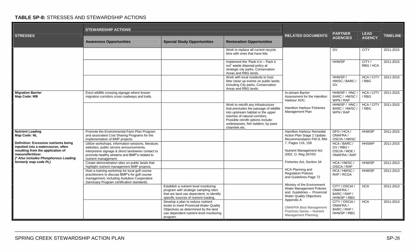
TABLE SP-8: STRESSES AND STEWARDSHIP ACTIONS
SPRING CREEK STEWARDSHIP ACTION PLAN SP-28
STRESSES
STEWARDSHIP ACTIONS
RELATED DOCUMENTS PARTNER AGENCIES
LEAD AGENCY
TIMELINE
Awareness Opportunities Special Study Opportunities Restoration Opportunities
Work to replace all current recycle bins with ones that have lids.
GV CITY 2011-2015
Implement the „Pack it in – Pack it out” waste disposal policy at strategic city parks, Conservation Areas and RBG lands.
HHWSP CITY / RBG / HCA
2011-2015
Work with local residents to host litter clean up events on public lands; including City parks, Conservation Areas and RBG lands.
HHWSP / HWSC / BARC / GV
HCA / CITY / RBG
2011-2015
Migration Barrier Map Code: MB
Erect wildlife crossing signage where known migration corridors cross roadways and trails.
In-stream Barrier Assessment for the Hamilton Harbour AOC. Hamilton Harbour Fisheries Management Plan
HHWSP / HNC / BARC / HWSC / WPN / RAP
HCA / CITY / RBG
2011-2015
Work to retrofit any infrastructure that precludes the passage of wildlife into upstream habitat or the upper reaches of natural corridors. Possible retrofit options include: underpasses, fish ladders, by-pass channels etc.
HHWSP / HNC / BARC / HWSC / WPN / RAP
HCA / CITY / RBG
2011-2015
Nutrient Loading Map Code: NL Definition: Excessive nutrients being inputted into a watercourse; often resulting from the application of manure/fertilizer. (* Also includes Phosphorous Loading formerly map code PL)
Promote the Environmental Farm Plan Program and associated Cost Sharing Programs for the implementation of BMP projects.
Hamilton Harbour Remedial Action Plan Stage 2 Update: Recommendation FW-9, RM-7. Pages 116, 158 Nutrient Management Act 2002, O. Reg 267/03 Fisheries Act, Section 34 HCA Planning and Regulation Policies and Guidelines Page 72 Ministry of the Environment Water Management Policies and Guidelines – Provincial Water Quality Objectives Appendix A OMAFRA Best Management Practices Series – Nutrient Management Planning
DFO / HCA / OMAFRA / OSCIA / HWSC
HHWSP 2011-2015
Utilize workshops, information sessions, literature, websites, public service announcements, interpretive signage & direct landowner contact to promote healthy streams and BMP‟s related to nutrient management.
HCA / BARC / GV / RBG / OSCIA / MOE / OMAFRA / RAP
HHSWP 2011-2015
Create demonstration sites on public lands that highlight nutrient management BMP projects.
HCA / HWSC / OSICA / RAP
HHWSP 2011-2013
Host a training workshop for local golf course practitioners to discuss BMP‟s for golf course management, including Audubon Cooperative Sanctuary Program certification standards.
HCA / HWSC / RAP / RCGA
HHWSP 2011-2013
Establish a nutrient level monitoring program with strategic sampling sites that are land use dependent, to identify specific sources of nutrient loading.
CITY / OSCIA / OMAFRA / BARC / RAP / HHWSP / RBG
HCA 2011-2013
Develop a plan to reduce nutrient levels to meet Provincial Water Quality Objectives as determined by the land use dependent nutrient level monitoring program.
CITY / OSCIA / OMAFRA / BARC / RAP / HHWSP / RBG
HCA 2011-2013
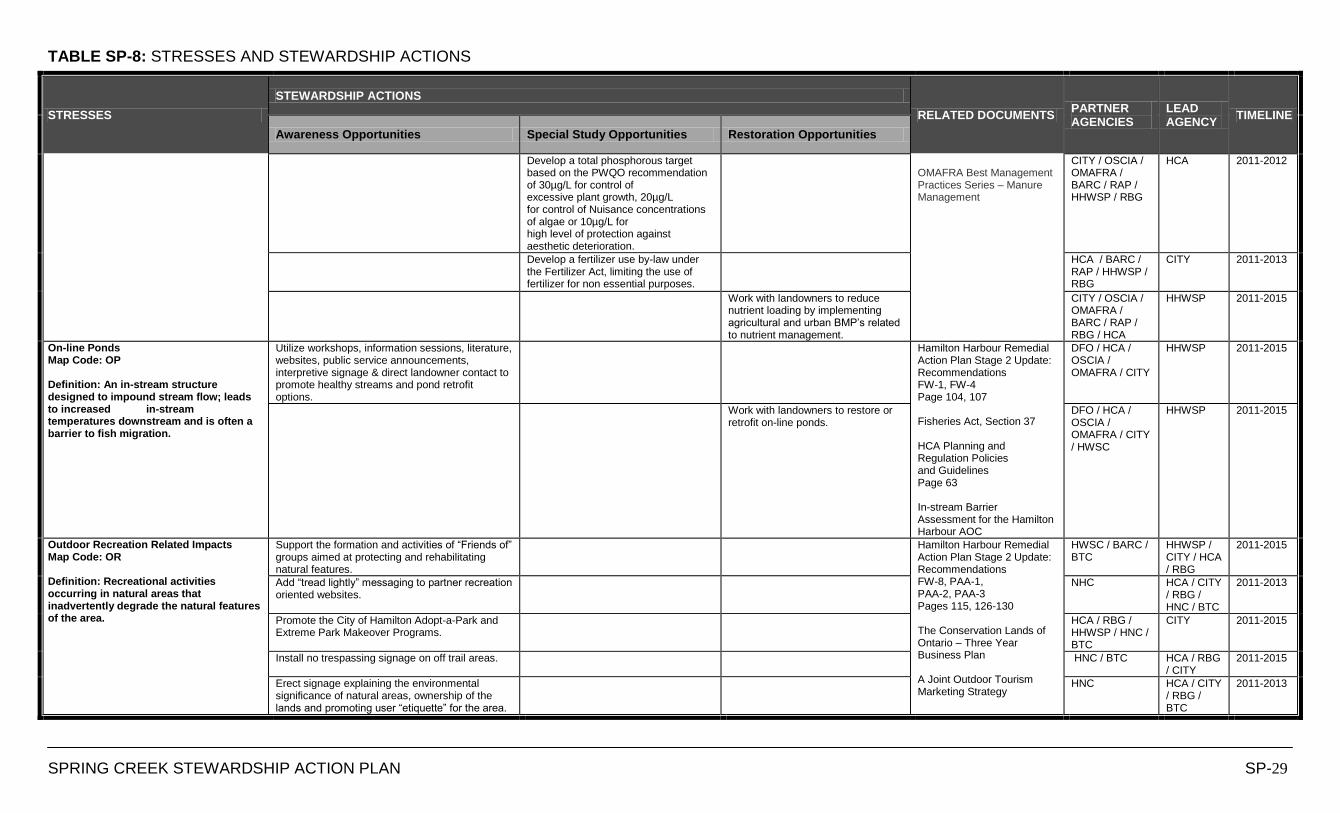
TABLE SP-8: STRESSES AND STEWARDSHIP ACTIONS
SPRING CREEK STEWARDSHIP ACTION PLAN SP-29
STRESSES
STEWARDSHIP ACTIONS
RELATED DOCUMENTS PARTNER AGENCIES
LEAD AGENCY
TIMELINE
Awareness Opportunities Special Study Opportunities Restoration Opportunities
Develop a total phosphorous target based on the PWQO recommendation of 30µg/L for control of excessive plant growth, 20µg/L for control of Nuisance concentrations of algae or 10µg/L for high level of protection against aesthetic deterioration.
OMAFRA Best Management Practices Series – Manure Management
CITY / OSCIA / OMAFRA / BARC / RAP / HHWSP / RBG
HCA 2011-2012
Develop a fertilizer use by-law under the Fertilizer Act, limiting the use of fertilizer for non essential purposes.
HCA / BARC / RAP / HHWSP / RBG
CITY 2011-2013
Work with landowners to reduce nutrient loading by implementing agricultural and urban BMP‟s related to nutrient management.
CITY / OSCIA / OMAFRA / BARC / RAP / RBG / HCA
HHWSP 2011-2015
On-line Ponds Map Code: OP Definition: An in-stream structure designed to impound stream flow; leads to increased in-stream temperatures downstream and is often a barrier to fish migration.
Utilize workshops, information sessions, literature, websites, public service announcements, interpretive signage & direct landowner contact to promote healthy streams and pond retrofit options.
Hamilton Harbour Remedial Action Plan Stage 2 Update: Recommendations FW-1, FW-4 Page 104, 107 Fisheries Act, Section 37 HCA Planning and Regulation Policies and Guidelines Page 63 In-stream Barrier Assessment for the Hamilton Harbour AOC
DFO / HCA / OSCIA / OMAFRA / CITY
HHWSP 2011-2015
Work with landowners to restore or retrofit on-line ponds.
DFO / HCA / OSCIA / OMAFRA / CITY / HWSC
HHWSP 2011-2015
Outdoor Recreation Related Impacts Map Code: OR Definition: Recreational activities occurring in natural areas that inadvertently degrade the natural features of the area.
Support the formation and activities of “Friends of” groups aimed at protecting and rehabilitating natural features.
Hamilton Harbour Remedial Action Plan Stage 2 Update: Recommendations FW-8, PAA-1, PAA-2, PAA-3 Pages 115, 126-130 The Conservation Lands of Ontario – Three Year Business Plan A Joint Outdoor Tourism Marketing Strategy
HWSC / BARC / BTC
HHWSP / CITY / HCA / RBG
2011-2015
Add “tread lightly” messaging to partner recreation oriented websites.
NHC HCA / CITY / RBG / HNC / BTC
2011-2013
Promote the City of Hamilton Adopt-a-Park and Extreme Park Makeover Programs.
HCA / RBG / HHWSP / HNC / BTC
CITY 2011-2015
Install no trespassing signage on off trail areas. HNC / BTC HCA / RBG / CITY
2011-2015
Erect signage explaining the environmental significance of natural areas, ownership of the lands and promoting user “etiquette” for the area.
HNC HCA / CITY / RBG / BTC
2011-2013
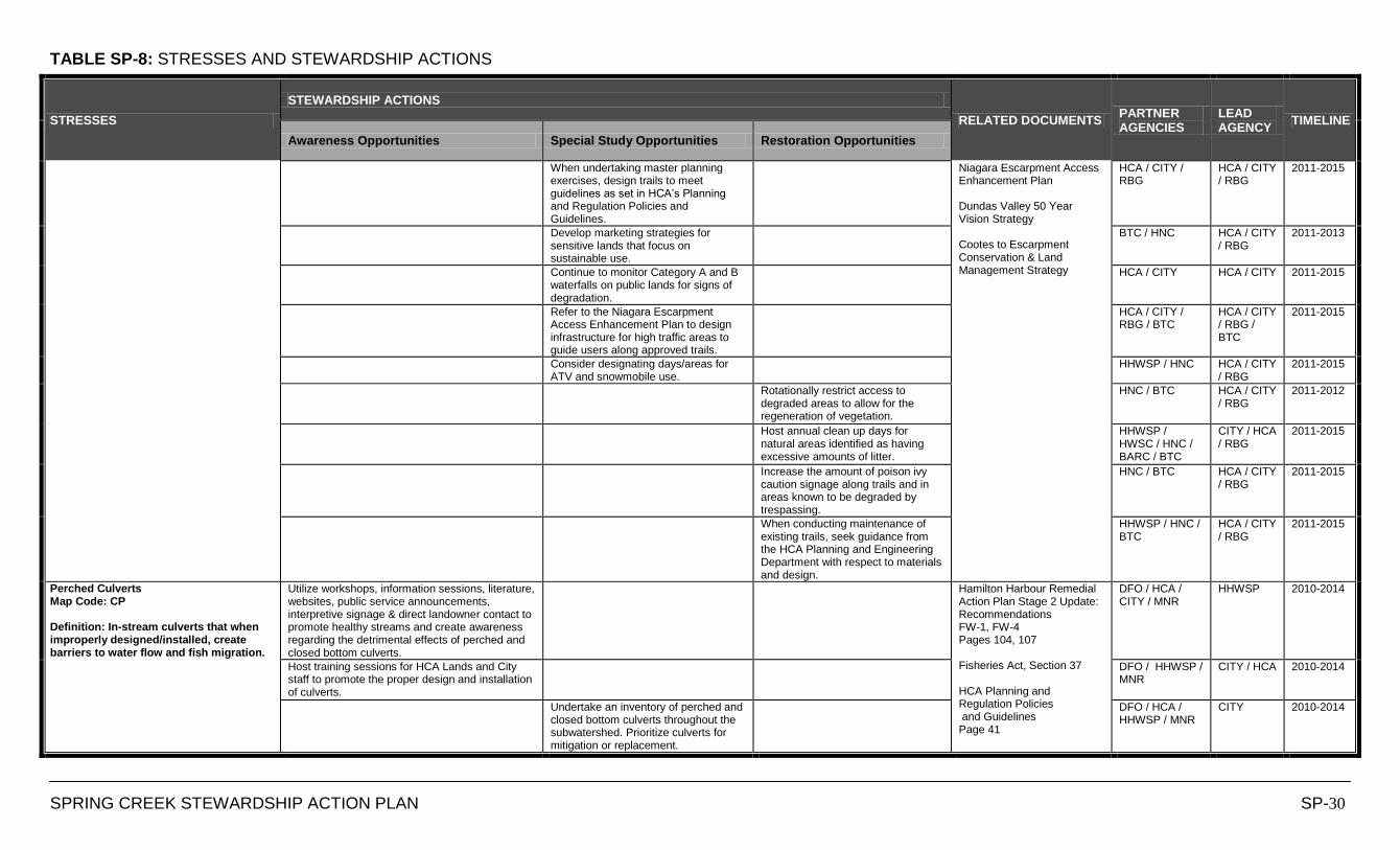
TABLE SP-8: STRESSES AND STEWARDSHIP ACTIONS
SPRING CREEK STEWARDSHIP ACTION PLAN SP-30
STRESSES
STEWARDSHIP ACTIONS
RELATED DOCUMENTS PARTNER AGENCIES
LEAD AGENCY
TIMELINE
Awareness Opportunities Special Study Opportunities Restoration Opportunities
When undertaking master planning exercises, design trails to meet guidelines as set in HCA‟s Planning and Regulation Policies and Guidelines.
Niagara Escarpment Access Enhancement Plan Dundas Valley 50 Year Vision Strategy Cootes to Escarpment Conservation & Land Management Strategy
HCA / CITY / RBG
HCA / CITY / RBG
2011-2015
Develop marketing strategies for sensitive lands that focus on sustainable use.
BTC / HNC HCA / CITY / RBG
2011-2013
Continue to monitor Category A and B waterfalls on public lands for signs of degradation.
HCA / CITY HCA / CITY 2011-2015
Refer to the Niagara Escarpment Access Enhancement Plan to design infrastructure for high traffic areas to guide users along approved trails.
HCA / CITY / RBG / BTC
HCA / CITY / RBG / BTC
2011-2015
Consider designating days/areas for ATV and snowmobile use.
HHWSP / HNC HCA / CITY / RBG
2011-2015
Rotationally restrict access to degraded areas to allow for the regeneration of vegetation.
HNC / BTC HCA / CITY / RBG
2011-2012
Host annual clean up days for natural areas identified as having excessive amounts of litter.
HHWSP / HWSC / HNC / BARC / BTC
CITY / HCA / RBG
2011-2015
Increase the amount of poison ivy caution signage along trails and in areas known to be degraded by trespassing.
HNC / BTC HCA / CITY / RBG
2011-2015
When conducting maintenance of existing trails, seek guidance from the HCA Planning and Engineering Department with respect to materials and design.
HHWSP / HNC / BTC
HCA / CITY / RBG
2011-2015
Perched Culverts Map Code: CP Definition: In-stream culverts that when improperly designed/installed, create barriers to water flow and fish migration.
Utilize workshops, information sessions, literature, websites, public service announcements, interpretive signage & direct landowner contact to promote healthy streams and create awareness regarding the detrimental effects of perched and closed bottom culverts.
Hamilton Harbour Remedial Action Plan Stage 2 Update: Recommendations FW-1, FW-4 Pages 104, 107 Fisheries Act, Section 37 HCA Planning and Regulation Policies and Guidelines Page 41
DFO / HCA / CITY / MNR
HHWSP 2010-2014
Host training sessions for HCA Lands and City staff to promote the proper design and installation of culverts.
DFO / HHWSP / MNR
CITY / HCA 2010-2014
Undertake an inventory of perched and closed bottom culverts throughout the subwatershed. Prioritize culverts for mitigation or replacement.
DFO / HCA / HHWSP / MNR
CITY 2010-2014
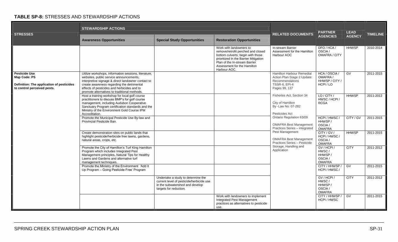
TABLE SP-8: STRESSES AND STEWARDSHIP ACTIONS
SPRING CREEK STEWARDSHIP ACTION PLAN SP-31
STRESSES
STEWARDSHIP ACTIONS
RELATED DOCUMENTS PARTNER AGENCIES
LEAD AGENCY
TIMELINE
Awareness Opportunities Special Study Opportunities Restoration Opportunities
Work with landowners to remove/retrofit perched and closed bottom culverts; begin with those prioritized in the Barrier Mitigation Plan of the In-stream Barrier Assessment for the Hamilton Harbour AOC.
In-stream Barrier Assessment for the Hamilton Harbour AOC
DFO / HCA / OSCIA / OMAFRA / CITY
HHWSP 2010-2014
Pesticide Use Map Code: PS Definition: The application of pesticides to control perceived pests.
Utilize workshops, information sessions, literature, websites, public service announcements, interpretive signage & direct landowner contact to create awareness regarding the detrimental effects of pesticides and herbicides and to promote alternatives to traditional methods.
Hamilton Harbour Remedial Action Plan Stage 2 Update: Recommendations TSSR-6, EPI-4 Pages 99, 137 Fisheries Act, Section 34 City of Hamilton By -Law No. 07-282 Pesticides Act Ontario Regulation 63/09 OMAFRA Best Management Practices Series – integrated Pest Management OMAFRA Best Management Practices Series – Pesticide Storage, Handling and Application
HCA / OSCIA / OMAFRA / HHWSP / CITY / HCPI / LO
GV 2011-2015
Host a training workshop for local golf course practitioners to discuss BMP‟s for golf course management, including Audubon Cooperative Sanctuary Program certification standards and the Ministry of the Environment Gold Course IPM Accreditation.
LO / CITY / HWSC / HCPI / RCGA
HHWSP 2011-2012
Promote the Municipal Pesticide Use By-law and Provincial Pesticide Ban.
HCPI / HWSC / HHWSP / OSCIA / OMAFRA
CITY / GV 2011-2015
Create demonstration sites on public lands that highlight pesticide/herbicide free lawns, gardens, natural areas, crops, etc.
CITY / GV / HCPI / HWSC / OSCIA / OMAFRA
HHWSP 2011-2015
Promote the City of Hamilton‟s Turf King Hamilton Program which includes Integrated Pest Management principles, Natural Tips for Healthy Lawns and Gardens and alternative turf management techniques.
GV / HCPI / HWSC / HHWSP / OSCIA / OMAFRA
CITY 2011-2012
Promote the Ministry of the Environment „Add It Up Program – Going Pesticide Free‟ Program
CITY / HHWSP / HCPI / HWSC /
GV 2011-2015
Undertake a study to determine the current level of pesticide/herbicide use in the subwatershed and develop targets for reduction.
GV / HCPI / HWSC / HHWSP / OSCIA / OMAFRA
CITY 2011-2012
Work with landowners to implement Integrated Pest Management practices as alternatives to pesticide use.
CITY / HHWSP / HCPI / HWSC
GV 2011-2015
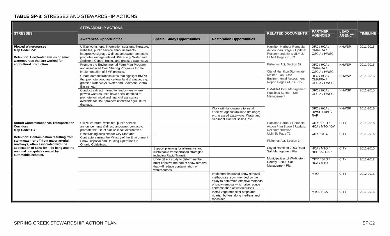
TABLE SP-8: STRESSES AND STEWARDSHIP ACTIONS
SPRING CREEK STEWARDSHIP ACTION PLAN SP-32
STRESSES
STEWARDSHIP ACTIONS
RELATED DOCUMENTS PARTNER AGENCIES
LEAD AGENCY
TIMELINE
Awareness Opportunities Special Study Opportunities Restoration Opportunities
Plowed Watercourses Map Code: PW Definition: Headwater swales or small watercourses that are worked for agricultural production.
Utilize workshops, information sessions, literature, websites, public service announcements, interpretive signage & direct landowner contact to promote drainage related BMP‟s; e.g. Water and Sediment Control Basins and grassed waterways.
Hamilton Harbour Remedial Action Plan Stage 2 Update: Recommendations ULM-3, ULM-4 Pages 70, 71 Fisheries Act, Section 37 City of Hamilton Stormwater Master Plan Class Environmental Assessment Report Pages 44, 145-150 OMAFRA Best Management Practices Series – Soil Management
DFO / HCA / OMAFRA / OSCIA / HWSC
HHWSP 2011-2015
Promote the Environmental Farm Plan Program and associated Cost Sharing Programs for the implementation of BMP projects.
DFO / HCA / OMAFRA / OSCIA / HWSC
HHWSP 2011-2015
Create demonstrations sites that highlight BMP‟s that promote good agricultural land drainage; e.g. grassed waterways, Water and Sediment Control Basins, etc.
DFO / HCA / OMAFRA / OSCIA / HWSC
HHWSP 2011-2013
Conduct a direct mailing to landowners where plowed watercourses have been identified to promote technical and financial assistance available for BMP projects related to agricultural drainage.
DFO / HCA / OSCIA / HWSC
HHWSP 2011-2015
Work with landowners to install effective agricultural land drainage; e.g. grassed waterways, Water and Sediment Control Basins, etc.
DFO / HCA / HWSC / RBG / RAP
HHWSP 2011-2015
Runoff Contamination via Transportation Corridors Map Code: TC Definition: Contamination resulting from stormwater runoff from major arterial roadways; often associated with the application of salts for de-icing and the residual precipitate created by automobile exhaust.
Utilize literature, websites, public service announcements & direct landowner contact to promote the use of sidewalk salt alternatives.
Hamilton Harbour Remedial Action Plan Stage 2 Update: Recommendation ULM-5b Page 71 Fisheries Act, Section 34 City of Hamilton 2003 Road Salt Management Plan Municipalities of Wellington County – 2005 Salt Management Plan
CITY / DFO / HCA / MTO / GV
CITY 2011-2015
Host training sessions for City Staff and Contractors using the Ministry of the Environment Snow Disposal and De-icing Operations in Ontario Guidelines.
. CITY / MTO CITY 2011-2015
Support planning for alternative and sustainable transportation strategies including Rapid Transit.
HCA / MTO / HHHBA / RAP
CITY 2011-2015
Undertake a study to determine the most effective method of snow removal that will reduce contamination of watercourses.
CITY / DFO / HCA / MTO
CITY 2011-2012
Implement improved snow removal methods as recommended by the study to determine effective methods of snow removal which also reduce contamination of watercourses.
MTO CITY 2012-2015
Install vegetated filter strips and riparian buffers along medians and roadsides.
MTO / HCA CITY 2011-2015

TABLE SP-8: STRESSES AND STEWARDSHIP ACTIONS
SPRING CREEK STEWARDSHIP ACTION PLAN SP-33
STRESSES
STEWARDSHIP ACTIONS
RELATED DOCUMENTS PARTNER AGENCIES
LEAD AGENCY
TIMELINE
Awareness Opportunities Special Study Opportunities Restoration Opportunities
Sediment Loading Map Code: SL Definition: Organic and inorganic material that is entrained by the flow of water and is deposited in a creek system.
Utilize workshops, information sessions, literature, websites, public service announcements, interpretive signage & direct landowner contact to promote healthy streams and BMP‟s related to preventing sedimentation.
Hamilton Harbour Remedial Action Plan Stage 2 Update: Recommendations ULM-3, ULM-5, FW9 Pages 70, 71, 116 Fisheries Act, Sections 34 and 36 Erosion and Sediment Control Guidelines for Urban Construction City of Hamilton By-law for Prohibiting and Regulating the Alteration of Property Grades, the Placing or Dumping of Fill, and the Removal of Topsoil OMAFRA Best Management Practices Series – No-Till Making it Work Ministry of the Environment Stormwater Management Design Guidelines
DFO / HWSC / HCA / MNR / OSCIA / OMAFRA / RAP
HHWSP 2011-2015
Develop a total suspended solids target based on the PWQO turbidity recommendation of between 5-50 FTU (Formazin Turbidity Units)
DFO / HWSC / HHWSP / MNR / OSCIA / OMAFRA / RAP
HCA 2011-2012
Work to achieve and maintain the total suspended solids target developed based on the PWQO turbidity recommendation of between 5-50 FTU (Formazin Turbidity Units)
DFO / HWSC / HHWSP / MNR / OSCIA / OMAFRA / RAP
HCA 2012-2015
Monitor and enforce the proper installation and maintenance of sediment and erosion control measure on construction sites.
DFO / HWSC / HHWSP / MNR / OSCIA / OMAFRA / RAP
HCA 2011-2015
Work with landowners to reduce sediment loading by implementing BMP projects; e.g. streambank stabilization, riparian buffers, natural channel design.
DFO / HWSC / HCA / MNR / OSCIA / OMAFRA
HHWSP 2011-2015
Work with contractors to ensure that site clearing prior to development is phased out as the project phases unfold to reduce the area and length of time bare soil is exposed.
DFO / HWSC / MNR / OSCIA / OMAFRA / RAP / HHHBA
HCA 2011-2015
Site Clearing Prior to Development Map Code: SC Definition: The act of stripping or excavating the vegetation and topsoil from a site prior to construction works.
Host training sessions for City staff, developers and consultants to promote City standards and guidelines related to site preparation prior to development.
Hamilton Harbour Remedial Action Plan Stage 2 Update: Recommendation ULM-4 Page 71 HCA Planning and Regulation Policies and Guidelines Pages 50-62, 68-69 City of Hamilton Draft Private Tree and Woodland Conservation By-Law
DFO / MNR / RAP / HHHBA / CITY / HWSC/ HHWSP
HCA 2011-2013
Promote the City of Hamilton By-law for Prohibiting and Regulating the Alteration of Property Grades, the Placing or Dumping of Fill, and the Removal of Topsoil
DFO / MNR / RAP / HHHBA / CITY / HWSC/ HHWSP
CITY 2011-2015
Work with contractors to ensure that only necessary areas of development sites are cleared prior to development to eliminate the unnecessary destruction of habitat.
DFO / MNR / HHHBA / CITY
HCA 2011-2015
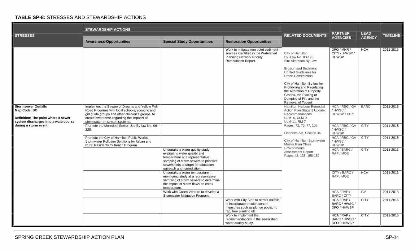
TABLE SP-8: STRESSES AND STEWARDSHIP ACTIONS
SPRING CREEK STEWARDSHIP ACTION PLAN SP-34
STRESSES
STEWARDSHIP ACTIONS
RELATED DOCUMENTS PARTNER AGENCIES
LEAD AGENCY
TIMELINE
Awareness Opportunities Special Study Opportunities Restoration Opportunities
Work to mitigate non point sediment sources identified in the Watershed Planning Network Priority Remediation Report.
City of Hamilton By -Law No. 03-126 Site Alteration By-Law Erosion and Sediment Control Guidelines for Urban Construction City of Hamilton By-law for Prohibiting and Regulating the Alteration of Property Grades, the Placing or Dumping of Fill, and the Removal of Topsoil
DFO / MNR / CITY / HWSP / HHWSP
HCA 2011-2015
Stormsewer Outfalls Map Code: SO Definition: The point where a sewer system discharges into a watercourse during a storm event.
Implement the Stream of Dreams and Yellow Fish Road Programs with local schools, scouting and girl guide groups and other children‟s groups, to create awareness regarding the impacts of stormwater on stream systems.
Hamilton Harbour Remedial Action Plan Stage 2 Update: Recommendations ULM -6, ULM-9, ULM-11, RM-7 Pages, 72, 75, 77, 158 Fisheries Act, Section 34 City of Hamilton Stormwater Master Plan Class Environmental Assessment Report Pages 43, 138, 158-159
HCA / RBG / GV / HWSC / HHWSP / CITY
BARC 2011-2015
Promote the Municipal Sewer-Use By-law No. 06-228.
HCA / RBG / GV / HWSC / HHWSP
CITY 2011-2015
Promote the City of Hamilton Public Works Stormwater Pollution Solutions for Urban and Rural Residents Outreach Program
HCA / RBG / GV / HWSC / HHWSP
CITY 2011-2015
Undertake a water quality study evaluating water quality and temperature at a representative sampling of storm sewers to prioritize sewersheds to target for education outreach and remediation.
HCA / BARC / RAP / MOE
CITY 2011-2013
Undertake a water temperature monitoring study at a representative sampling of storm sewers to determine the impact of storm flows on creek temperature.
CITY / BARC / RAP / MOE
HCA 2011-2013
Work with Green Venture to develop a Stormwater Mitigation Program.
HCA / RAP / BARC / CITY
GV 2011-2013
Work with City Staff to retrofit outfalls to incorporate erosion control measures such as plunge pools, rip rap, tree planting etc.
HCA / RAP / BARC / HWSC / DFO / HHWSP
CITY 2011-2015
Work to implement the recommendations in the sewershed water quality study.
HCA / RAP / BARC / HWSC / DFO / HHWSP
CITY 2011-2015
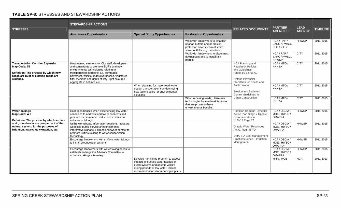
TABLE SP-8: STRESSES AND STEWARDSHIP ACTIONS
SPRING CREEK STEWARDSHIP ACTION PLAN SP-35
STRESSES
STEWARDSHIP ACTIONS
RELATED DOCUMENTS PARTNER AGENCIES
LEAD AGENCY
TIMELINE
Awareness Opportunities Special Study Opportunities Restoration Opportunities
Work with landowners to establish riparian buffers and/or erosion protection downstream of storm sewer outfalls; e.g. riverstone.
HCA / RAP / BARC / HWSC / DFO / CITY
HHWSP 2011-2015
Work with landowners to disconnect downspouts and to install rain barrels.
HCA / RAP / BARC / HWSC / HHWSP
CITY 2011-2015
Transportation Corridor Expansion Map Code: TE Definition: The process by which new roads are built or existing roads are widened.
Host training sessions for City staff, developers and consultants to promote BMP‟s and new environmental technologies relating to transportation corridors; e.g. permeable pavement, wildlife under/overpasses, vegetated filter medians and rights of way, light coloured aggregate in hot mix, etc.
. HCA Planning and Regulation Policies and Guidelines Pages 50-62, 68-69 Ontario Provincial Standards for Roads and Public Works Erosion and Sediment Control Guidelines for Urban Construction
HCA / MTO / HHHBA
CITY 2011-2015
When planning for major road works, design transportation corridors using new technologies for environmental solutions.
HCA / MTO / HHHBA
CITY 2011-2015
When repairing roads, utilize new technologies for road maintenance that are proven to have environmental benefits.
HCA / MTO / HHHBA
CITY 2011-2015
Water Takings Map Code: WT Definition: The process by which surface and groundwater are pumped out of the natural system; for the purposes of irrigation, aggregate extraction, etc.
Host open houses when experiencing low water conditions to address landowner concerns and promote recommended reductions in rates and volumes of takings.
Hamilton Harbour Remedial Action Plan Stage 2 Update: Recommendation ULM-12 Page 77 Ontario Water Resources Act O. Reg. 387/04 OMAFRA Best Management Practices Series – Irrigation Management
HCA / OSCIA / MOE / HWSC / OMAFRA
HHWSP 2011-2015
Utilize workshops, information sessions, literature, websites, public service announcements, interpretive signage & direct landowner contact to promote BMP‟s relating to water conservation technology.
HCA / OSCIA / MOE / HWSC / OMAFRA
HHWSP 2011-2015
Encourage landowners with surface water takings to install groundwater systems.
HCA / OSCIA / MOE / HWSC / OMAFRA
HHWSP 2011-2015
Encourage landowners with water taking needs to establish an Irrigation Advisory Committee to schedule takings alternately.
HCA / OSCIA / MOE / HWSC / OMAFRA
HHWSP 2011-2015
Develop monitoring program to assess impacts of surface water takings on creek systems and aquatic wildlife during periods of low water, include recommendations for reducing impacts.
MNR / MOE HCA 2011-2013
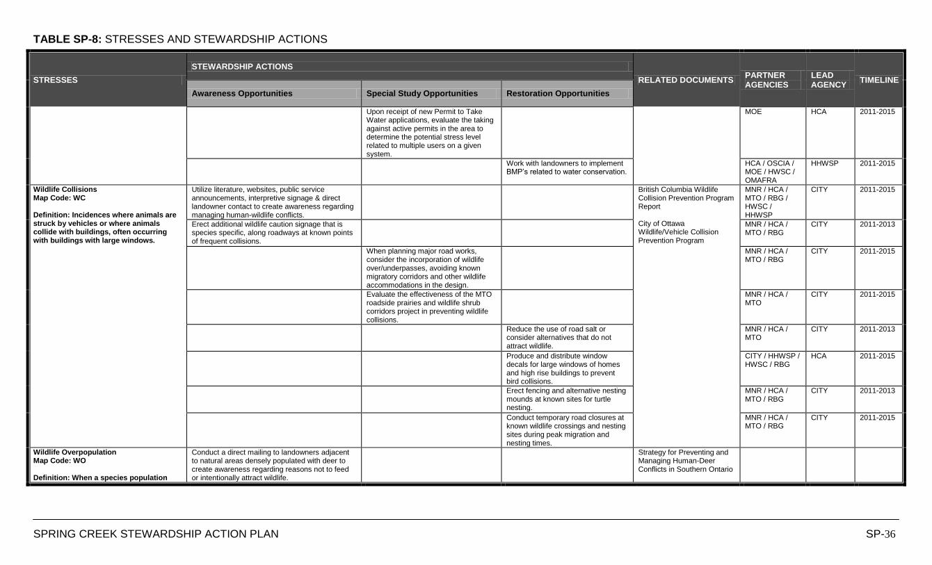
TABLE SP-8: STRESSES AND STEWARDSHIP ACTIONS
SPRING CREEK STEWARDSHIP ACTION PLAN SP-36
STRESSES
STEWARDSHIP ACTIONS
RELATED DOCUMENTS PARTNER AGENCIES
LEAD AGENCY
TIMELINE
Awareness Opportunities Special Study Opportunities Restoration Opportunities
Upon receipt of new Permit to Take Water applications, evaluate the taking against active permits in the area to determine the potential stress level related to multiple users on a given system.
MOE HCA 2011-2015
Work with landowners to implement BMP‟s related to water conservation.
HCA / OSCIA / MOE / HWSC / OMAFRA
HHWSP 2011-2015
Wildlife Collisions Map Code: WC Definition: Incidences where animals are struck by vehicles or where animals collide with buildings, often occurring with buildings with large windows.
Utilize literature, websites, public service announcements, interpretive signage & direct landowner contact to create awareness regarding managing human-wildlife conflicts.
British Columbia Wildlife Collision Prevention Program Report City of Ottawa Wildlife/Vehicle Collision Prevention Program
MNR / HCA / MTO / RBG / HWSC / HHWSP
CITY 2011-2015
Erect additional wildlife caution signage that is species specific, along roadways at known points of frequent collisions.
MNR / HCA / MTO / RBG
CITY 2011-2013
When planning major road works, consider the incorporation of wildlife over/underpasses, avoiding known migratory corridors and other wildlife accommodations in the design.
MNR / HCA / MTO / RBG
CITY 2011-2015
Evaluate the effectiveness of the MTO roadside prairies and wildlife shrub corridors project in preventing wildlife collisions.
MNR / HCA / MTO
CITY 2011-2015
Reduce the use of road salt or consider alternatives that do not attract wildlife.
MNR / HCA / MTO
CITY 2011-2013
Produce and distribute window decals for large windows of homes and high rise buildings to prevent bird collisions.
CITY / HHWSP / HWSC / RBG
HCA 2011-2015
Erect fencing and alternative nesting mounds at known sites for turtle nesting.
MNR / HCA / MTO / RBG
CITY 2011-2013
Conduct temporary road closures at known wildlife crossings and nesting sites during peak migration and nesting times.
MNR / HCA / MTO / RBG
CITY 2011-2015
Wildlife Overpopulation Map Code: WO Definition: When a species population
Conduct a direct mailing to landowners adjacent to natural areas densely populated with deer to create awareness regarding reasons not to feed or intentionally attract wildlife.
Strategy for Preventing and Managing Human-Deer Conflicts in Southern Ontario
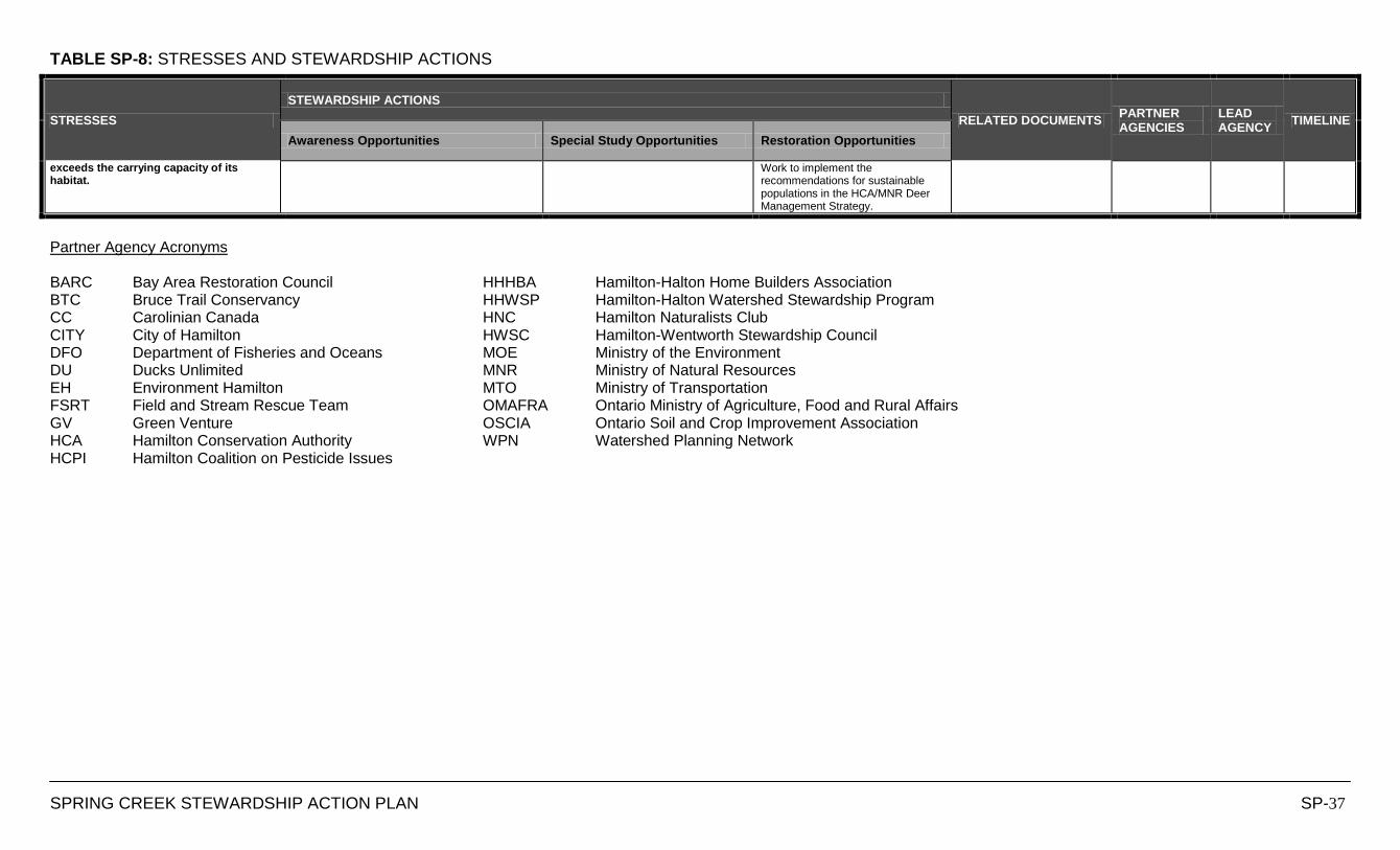
TABLE SP-8: STRESSES AND STEWARDSHIP ACTIONS
SPRING CREEK STEWARDSHIP ACTION PLAN SP-37
STRESSES
STEWARDSHIP ACTIONS
RELATED DOCUMENTS PARTNER AGENCIES
LEAD AGENCY
TIMELINE
Awareness Opportunities Special Study Opportunities Restoration Opportunities
exceeds the carrying capacity of its habitat.
Work to implement the recommendations for sustainable populations in the HCA/MNR Deer Management Strategy.
Partner Agency Acronyms BARC Bay Area Restoration Council HHHBA Hamilton-Halton Home Builders Association BTC Bruce Trail Conservancy HHWSP Hamilton-Halton Watershed Stewardship Program CC Carolinian Canada HNC Hamilton Naturalists Club CITY City of Hamilton HWSC Hamilton-Wentworth Stewardship Council DFO Department of Fisheries and Oceans MOE Ministry of the Environment DU Ducks Unlimited MNR Ministry of Natural Resources EH Environment Hamilton MTO Ministry of Transportation FSRT Field and Stream Rescue Team OMAFRA Ontario Ministry of Agriculture, Food and Rural Affairs GV Green Venture OSCIA Ontario Soil and Crop Improvement Association HCA Hamilton Conservation Authority WPN Watershed Planning Network HCPI Hamilton Coalition on Pesticide Issues


COPETOWN EAST CATCHMENT
DATA SHEETS
Hamilton Harbour
Lower Spencer
Creek
Sulphur Creek
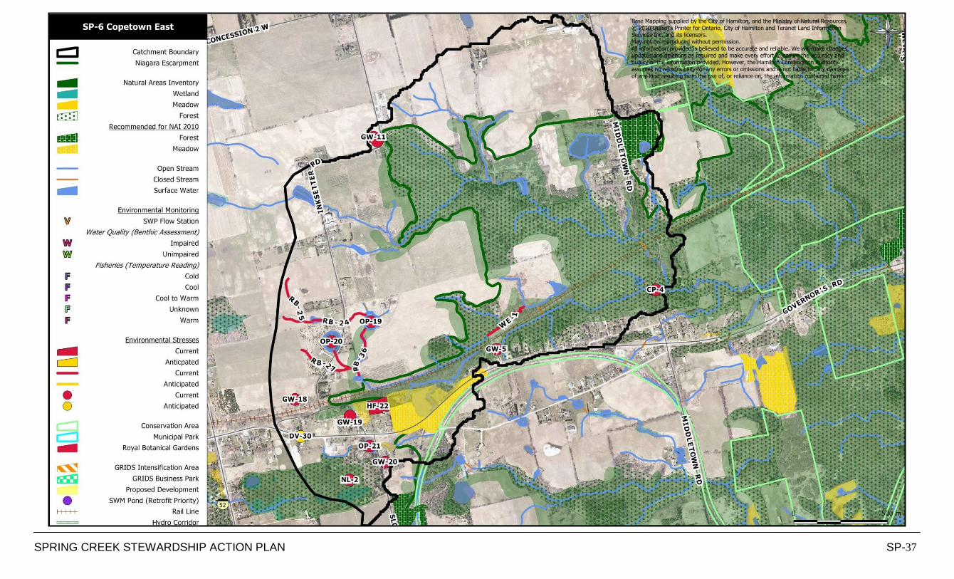
SPRING CREEK STEWARDSHIP ACTION PLAN SP-37
Base Mapping supplied by the City of Hamilton, and the Ministry of Natural Resources.
© 2010 Queen’s Printer for Ontario, City of Hamilton and Teranet Land Information Services Inc. and its licensors. May not be reproduced without permission.
All information provided is believed to be accurate and reliable. We will make changes, updates and deletions as required and make every effort to ensure the accuracy and quality of the information provided. However, the Hamilton Conservation Authority
assumes no responsibility for any errors or omissions and is not liable for any damages of any kind resulting from the use of, or reliance on, the information contained herein.
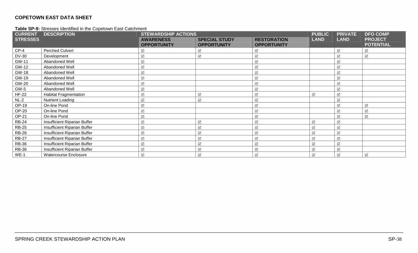
COPETOWN EAST DATA SHEET
SPRING CREEK STEWARDSHIP ACTION PLAN SP-38
Table SP-9: Stresses Identified in the Copetown East Catchment
CURRENT STRESSES
DESCRIPTION STEWARDSHIP ACTIONS PUBLIC LAND
PRIVATE LAND
DFO COMP PROJECT POTENTIAL
AWARENESS OPPORTUNITY
SPECIAL STUDY OPPORTUNITY
RESTORATION OPPORTUNITY
CP-4 Perched Culvert
DV-30 Development
GW-11 Abandoned Well
GW-12 Abandoned Well
GW-18 Abandoned Well
GW-19 Abandoned Well
GW-20 Abandoned Well
GW-5 Abandoned Well
HF-22 Habitat Fragmentation
NL-2 Nutrient Loading
OP-19 On-line Pond
OP-20 On-line Pond
OP-21 On-line Pond
RB-24 Insufficient Riparian Buffer
RB-25 Insufficient Riparian Buffer
RB-26 Insufficient Riparian Buffer
RB-27 Insufficient Riparian Buffer
RB-36 Insufficient Riparian Buffer
RB-36 Insufficient Riparian Buffer
WE-1 Watercourse Enclosure
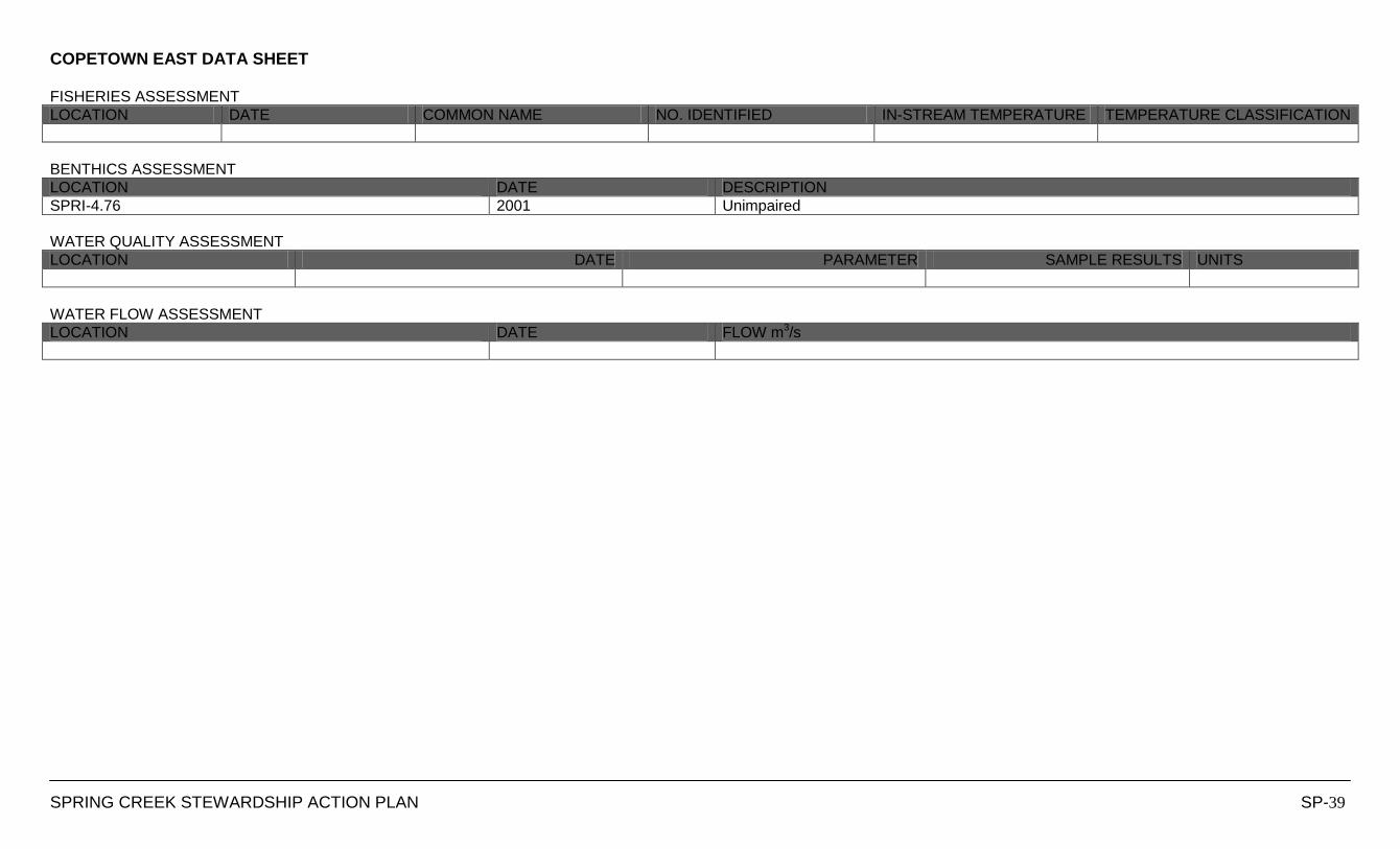
COPETOWN EAST DATA SHEET
SPRING CREEK STEWARDSHIP ACTION PLAN SP-39
FISHERIES ASSESSMENT
LOCATION DATE COMMON NAME NO. IDENTIFIED IN-STREAM TEMPERATURE TEMPERATURE CLASSIFICATION
BENTHICS ASSESSMENT
LOCATION DATE DESCRIPTION
SPRI-4.76 2001 Unimpaired
WATER QUALITY ASSESSMENT
LOCATION DATE PARAMETER SAMPLE RESULTS UNITS
WATER FLOW ASSESSMENT
LOCATION DATE FLOW m3/s
LOWER SPRING CREEK CATCHMENT
DATA SHEETS
Hamilton Harbour
Lower Spencer Creek
Sulphur Creek
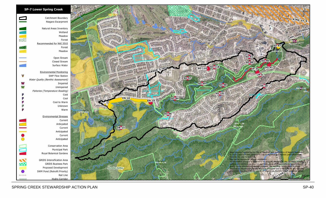
SPRING CREEK STEWARDSHIP ACTION PLAN SP-40
Base Mapping supplied by the City of Hamilton, and the Ministry of Natural Resources. © 2010 Queen’s Printer for Ontario, City of Hamilton and Teranet Land Information Services Inc. and its licensors.
May not be reproduced without permission. All information provided is believed to be accurate and reliable. We will make changes, updates and deletions as required and make every effort to ensure the accuracy and
quality of the information provided. However, the Hamilton Conservation Authority assumes no responsibility for any errors or omissions and is not liable for any damages of any kind resulting from the use of, or reliance on, the information contained herein.

LOWER SPRING CREEK DATA SHEET
SPRING CREEK STEWARDSHIP ACTION PLAN SP-41
Table SP-10: Stresses Identified in the Lower Spring Creek Catchment
CURRENT STRESSES
DESCRIPTION STEWARDSHIP ACTIONS PUBLIC LAND
PRIVATE LAND
DFO COMP PROJECT POTENTIAL
AWARENESS OPPORTUNITY
SPECIAL STUDY OPPORTUNITY
RESTORATION OPPORTUNITY
EN-10 Encroachment
EN-10 Encroachment
EN-13 Encroachment
ER-30 Erosion
HF-28 Habitat Fragmentation
LM-6 Land Maintenance Practices
OR-15 Outdoor Recreation Related Impacts
SO-101 Stormsewer Outfall
SO-102 Stormsewer Outfall
SO-118 Stormsewer Outfall
SO-119 Stormsewer Outfall
SO-84 Stormsewer Outfall
SO-85 Stormsewer Outfall
SO-87 Stormsewer Outfall
SO-89 Stormsewer Outfall
SO-90 Stormsewer Outfall
SO-91 Stormsewer Outfall
SO-92 Stormsewer Outfall
SO-96 Stormsewer Outfall
SO-97 Stormsewer Outfall
SO-98 Stormsewer Outfall
SO-99 Stormsewer Outfall
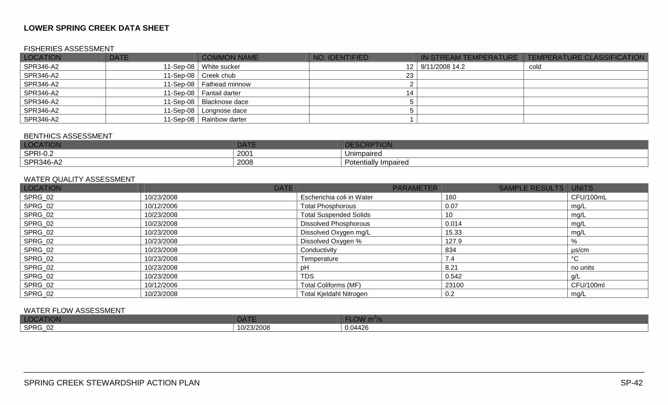
LOWER SPRING CREEK DATA SHEET
SPRING CREEK STEWARDSHIP ACTION PLAN SP-42
FISHERIES ASSESSMENT
LOCATION DATE COMMON NAME NO. IDENTIFIED IN-STREAM TEMPERATURE TEMPERATURE CLASSIFICATION
SPR346-A2 11-Sep-08 White sucker 12 9/11/2008 14.2 cold
SPR346-A2 11-Sep-08 Creek chub 23
SPR346-A2 11-Sep-08 Fathead minnow 2
SPR346-A2 11-Sep-08 Fantail darter 14
SPR346-A2 11-Sep-08 Blacknose dace 5
SPR346-A2 11-Sep-08 Longnose dace 5
SPR346-A2 11-Sep-08 Rainbow darter 1
BENTHICS ASSESSMENT
LOCATION DATE DESCRPTION
SPRI-0.2 2001 Unimpaired
SPR346-A2 2008 Potentially Impaired
WATER QUALITY ASSESSMENT
LOCATION DATE PARAMETER SAMPLE RESULTS UNITS
SPRG_02 10/23/2008 Escherichia coli in Water 160 CFU/100mL
SPRG_02 10/12/2006 Total Phosphorous 0.07 mg/L
SPRG_02 10/23/2008 Total Suspended Solids 10 mg/L
SPRG_02 10/23/2008 Dissolved Phosphorous 0.014 mg/L
SPRG_02 10/23/2008 Dissolved Oxygen mg/L 15.33 mg/L
SPRG_02 10/23/2008 Dissolved Oxygen % 127.9 %
SPRG_02 10/23/2008 Conductivity 834 µs/cm
SPRG_02 10/23/2008 Temperature 7.4 °C
SPRG_02 10/23/2008 pH 8.21 no units
SPRG_02 10/23/2008 TDS 0.542 g/L
SPRG_02 10/12/2006 Total Coliforms (MF) 23100 CFU/100ml
SPRG_02 10/23/2008 Total Kjeldahl Nitrogen 0.2 mg/L
WATER FLOW ASSESSMENT
LOCATION DATE FLOW m3/s SPRG_02 10/23/2008 0.04426
MIDDLE SPRING CREEK CATCHMENT
DATA SHEETS
Hamilton Harbour
Lower Spencer Creek
Sulphur Creek
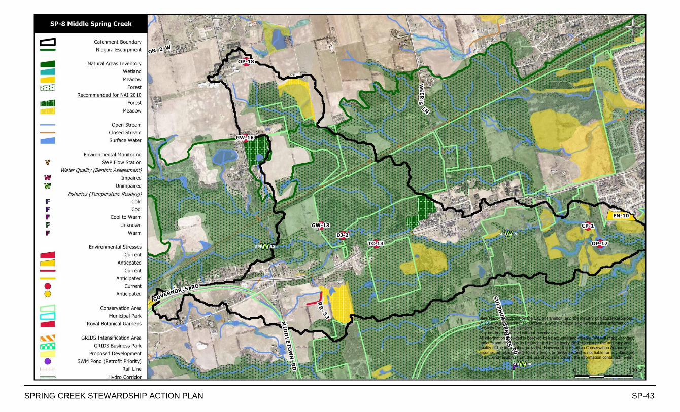
SPRING CREEK STEWARDSHIP ACTION PLAN SP-43
Base Mapping supplied by the City of Hamilton, and the Ministry of Natural Resources.
© 2010 Queen’s Printer for Ontario, City of Hamilton and Teranet Land Information Services Inc. and its licensors. May not be reproduced without permission.
All information provided is believed to be accurate and reliable. We will make changes, updates and deletions as required and make every effort to ensure the accuracy and quality of the information provided. However, the Hamilton Conservation Authority
assumes no responsibility for any errors or omissions and is not liable for any damages of any kind resulting from the use of, or reliance on, the information contained herein.
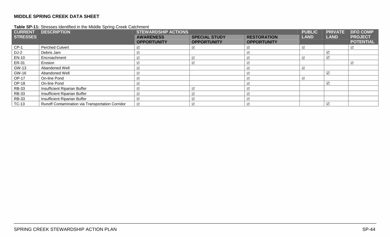
MIDDLE SPRING CREEK DATA SHEET
SPRING CREEK STEWARDSHIP ACTION PLAN SP-44
Table SP-11: Stresses Identified in the Middle Spring Creek Catchment
CURRENT STRESSES
DESCRIPTION STEWARDSHIP ACTIONS PUBLIC LAND
PRIVATE LAND
DFO COMP PROJECT POTENTIAL
AWARENESS OPPORTUNITY
SPECIAL STUDY OPPORTUNITY
RESTORATION OPPORTUNITY
CP-1 Perched Culvert
DJ-2 Debris Jam
EN-10 Encroachment
ER-31 Erosion
GW-13 Abandoned Well
GW-16 Abandoned Well
OP-17 On-line Pond
OP-18 On-line Pond
RB-33 Insufficient Riparian Buffer
RB-33 Insufficient Riparian Buffer
RB-33 Insufficient Riparian Buffer
TC-13 Runoff Contamination via Transportation Corridor
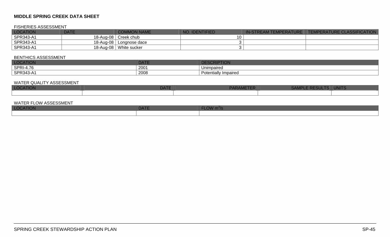
MIDDLE SPRING CREEK DATA SHEET
SPRING CREEK STEWARDSHIP ACTION PLAN SP-45
FISHERIES ASSESSMENT
LOCATION DATE COMMON NAME NO. IDENTIFIED IN-STREAM TEMPERATURE TEMPERATURE CLASSIFICATION
SPR343-A1 18-Aug-08 Creek chub 10
SPR343-A1 18-Aug-08 Longnose dace 3
SPR343-A1 18-Aug-08 White sucker 3
BENTHICS ASSESSMENT
LOCATION DATE DESCRIPTION
SPRI-4.76 2001 Unimpaired
SPR343-A1 2008 Potentially Impaired
WATER QUALITY ASSESSMENT
LOCATION DATE PARAMETER SAMPLE RESULTS UNITS
WATER FLOW ASSESSMENT
LOCATION DATE FLOW m3/s
SOUTHERN HEADWATERS CATCHMENT
DATA SHEETS
Hamilton Harbour
Lower Spencer Creek
Sulphur Creek
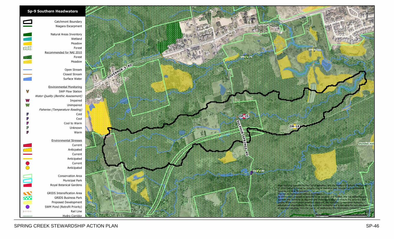
SPRING CREEK STEWARDSHIP ACTION PLAN SP-46
Base Mapping supplied by the City of Hamilton, and the Ministry of Natural Resources.
© 2010 Queen’s Printer for Ontario, City of Hamilton and Teranet Land Information Services Inc. and its licensors. May not be reproduced without permission.
All information provided is believed to be accurate and reliable. We will make changes, updates and deletions as required and make every effort to ensure the accuracy and
quality of the information provided. However, the Hamilton Conservation Authority assumes no responsibility for any errors or omissions and is not liable for any damages of any kind resulting from the use of, or reliance on, the information contained herein.
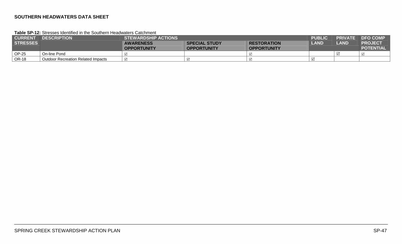
SOUTHERN HEADWATERS DATA SHEET
SPRING CREEK STEWARDSHIP ACTION PLAN SP-47
Table SP-12: Stresses Identified in the Southern Headwaters Catchment
CURRENT STRESSES
DESCRIPTION STEWARDSHIP ACTIONS PUBLIC LAND
PRIVATE LAND
DFO COMP PROJECT POTENTIAL
AWARENESS OPPORTUNITY
SPECIAL STUDY OPPORTUNITY
RESTORATION OPPORTUNITY
OP-25 On-line Pond
OR-18 Outdoor Recreation Related Impacts
SOUTHERN HEADWATERS DATA SHEET
SPRING CREEK STEWARDSHIP ACTION PLAN SP-48
FISHERIES ASSESSMENT
LOCATION DATE COMMON NAME NO. IDENTIFIED IN-STREAM TEMPERATURE TEMPERATURE CLASSIFICATION
BENTHICS ASSESSMENT
LOCATION DATE DESCRIPTION
WATER QUALITY ASSESSMENT
LOCATION DATE PARAMETER SAMPLE RESULTS UNITS
WATER FLOW ASSESSMENT
LOCATION DATE FLOW m3/s
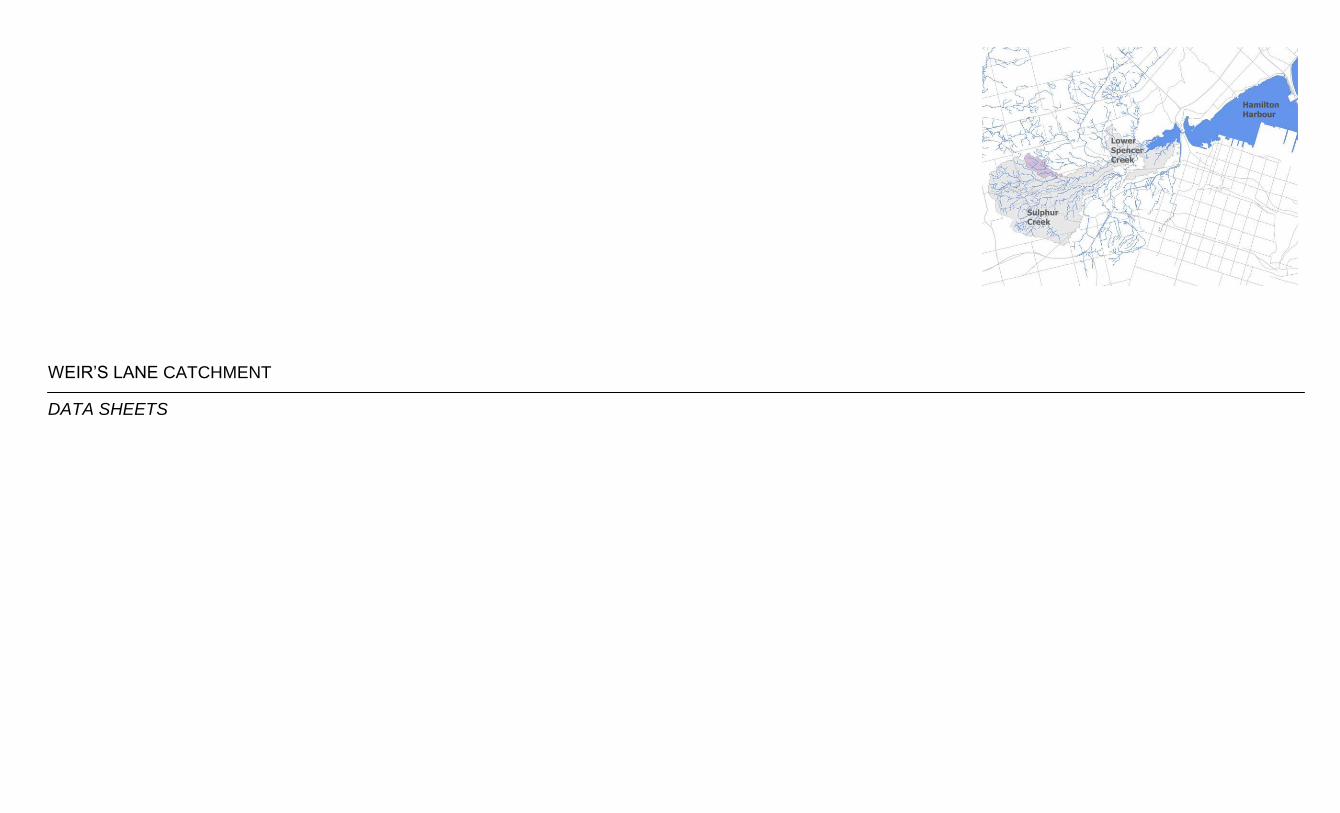
WEIR‟S LANE CATCHMENT
DATA SHEETS
Hamilton Harbour
Lower Spencer Creek
Sulphur Creek
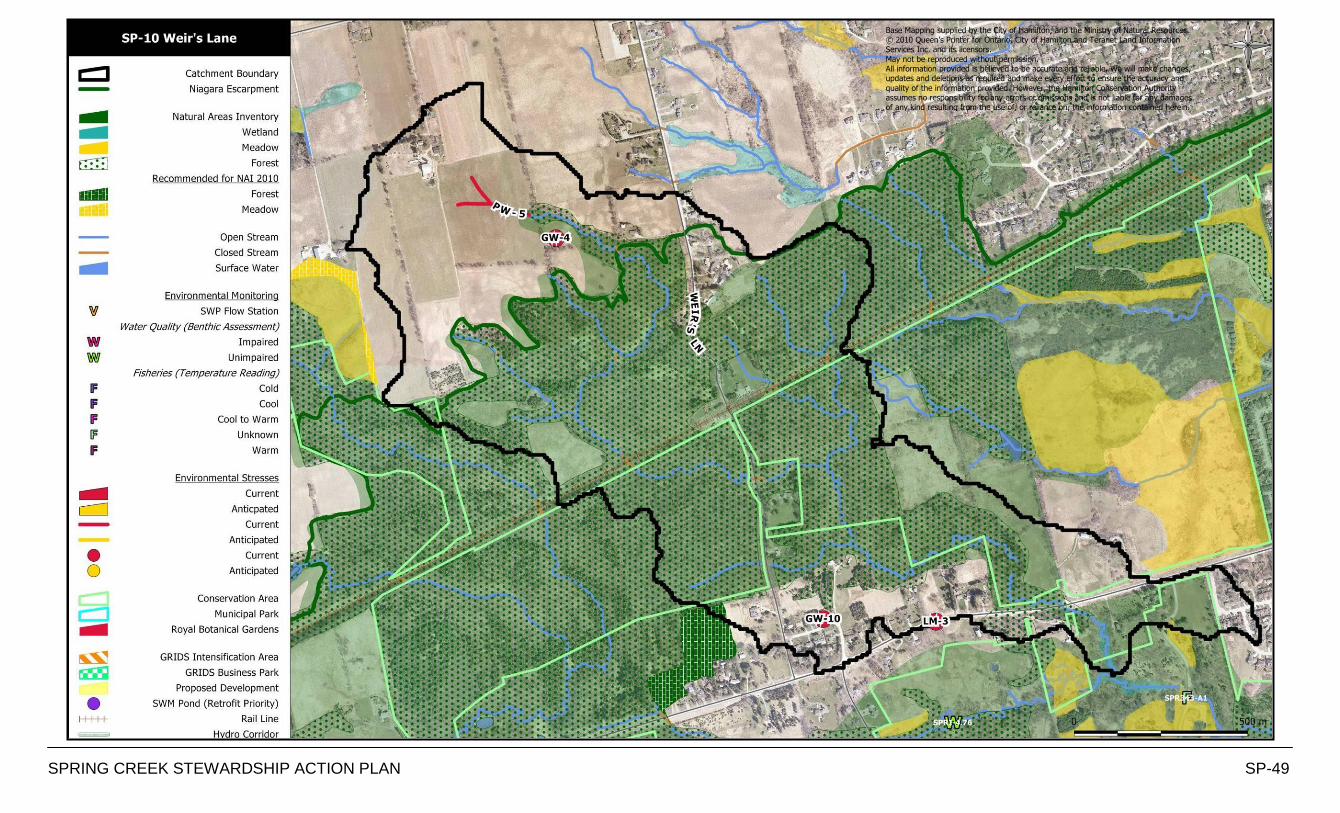
SPRING CREEK STEWARDSHIP ACTION PLAN SP-49
Base Mapping supplied by the City of Hamilton, and the Ministry of Natural Resources. © 2010 Queen’s Printer for Ontario, City of Hamilton and Teranet Land Information Services Inc. and its licensors.
May not be reproduced without permission. All information provided is believed to be accurate and reliable. We will make changes, updates and deletions as required and make every effort to ensure the accuracy and
quality of the information provided. However, the Hamilton Conservation Authority assumes no responsibility for any errors or omissions and is not liable for any damages of any kind resulting from the use of, or reliance on, the information contained herein.
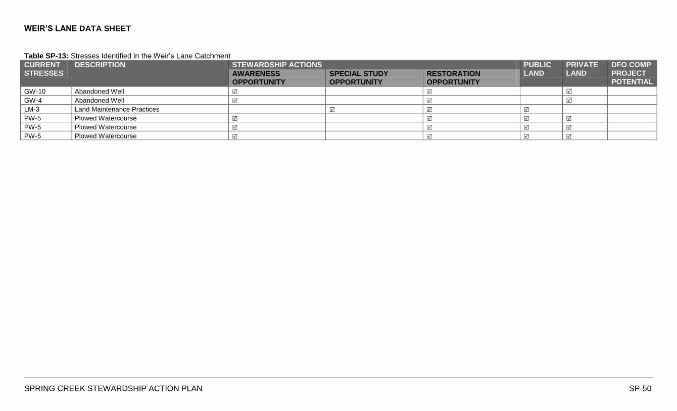
WEIR’S LANE DATA SHEET
SPRING CREEK STEWARDSHIP ACTION PLAN SP-50
Table SP-13: Stresses Identified in the Weir‟s Lane Catchment
CURRENT STRESSES
DESCRIPTION STEWARDSHIP ACTIONS PUBLIC LAND
PRIVATE LAND
DFO COMP PROJECT POTENTIAL
AWARENESS OPPORTUNITY
SPECIAL STUDY OPPORTUNITY
RESTORATION OPPORTUNITY
GW-10 Abandoned Well
GW-4 Abandoned Well
LM-3 Land Maintenance Practices
PW-5 Plowed Watercourse
PW-5 Plowed Watercourse
PW-5 Plowed Watercourse
WEIR’S LANE DATA SHEET
SPRING CREEK STEWARDSHIP ACTION PLAN SP-51
FISHERIES ASSESSMENT
LOCATION DATE COMMON NAME NO. IDENTIFIED IN-STREAM TEMPERATURE TEMPERATURE CLASSIFICATION
BENTHICS ASSESSMENT
LOCATION DATE DESCRPTION
WATER QUALITY ASSESSMENT
LOCATION DATE PARAMETER SAMPLE RESULTS UNITS
WATER FLOW ASSESSMENT
LOCATION DATE FLOW m3/s