Embed Size (px)
Citation preview

Geological, Geophysical, and Physical ASSESSMENT REPORT
on the
SPRING PROPERTY
Spring Creek (220706), Epi (705995), Thermal (705996), Trout Creek (705997) Claims
Similkameen Mining Division
NTS 092 H 16 E 1:20,000 Trim Map / Claim Map Designation
MO92 H 080
Initial Claim Posts of all claims by GPS in UTM Zone 10, NAD 83 706253 East
5517451 North
49” 46’ North Latitude 120” 08’ West Longitude
\ for Owner and Operator N-SYNC INDUSTRIES INC.
511 - 475 Howe Street Vancouver, B. C.
V6B 2B3 Tel (604) 687-7828
Alex Burton, P. Eng., P. Geo. Consulting Geologist
BURTON CONSULTING INC. 1408 - 7th Avenue
New Westminster, B. C. V3M 2K3
Tel / Fax: (604) 5258403
And
David fl@r~~&i$I~AI, $I!Dv.%-[ RRAkbTiCH Consulting Geophysicist .. -:., ,..*
GEOTRONICS SURVEYS LTD. 6204 - 1251h Street, V3X 2El

TABLE OF CONTENTS
TABLE OF CONTENTS ....................................................................................................... 2
LIST OF ILLUSTRATIONS ................................................................................................. 3 I, INTRODUCTION ........................................................................................................ 1 2 SUMMARY OF WORK DONE .................................................................................. 3
Geophvsical Survey.. ........................................................................................................ 3 Geological Survey.. ........................................................................................................... 3 Topographic Survey.. ........................................................................................................ 3 Linecutting.. ...................................................................................................................... 3 Claims Actuallv Worked On.. ........................................................................................... 3
& PROPERTY DESCRIPTION AND LOCATION.. ........................................................ 4 . ACCESSIBILITY, CLIMATE. LOCAL RESOURCES. INFRASTRUCTURE AND PHYSIOGRAPHY.. .............................................................................................................. 5 5 GEOLOGICAL SETTING ........................................................................................... 5 . MINERALIZATION .................................................................................................... 7 2, EXPLORATION ......................................................................................................... 10 8, GEOPHYSICS.. .......................................................................................................... 11
Golden Pick Resources Work - 1987 ............................................................................. 1 1 Placer Dome Work - 1988 and 1989.. ............................................................................ 11 In-Sync Industries Work - 2002.. ................................................................................... 12
K DISCUSSION OF RESULTS.. ................................................................................... 13 Main Zone.. ..................................................................................................................... 13 Breccia Zone.. ................................................................................................................. 13 Pat Zone .......................................................................................................................... 14 30-Meter Alteration Zone ............................................................................................... 14 Placer Dome Geophvsics ................................................................................................ 14
INTERPRETATION AND CONCLUSIONS.. ...................................................... 15
RECOMMENDATIONS.. ..................................................... . .............................................. 16
BUDGET ................................................................................................................................ 16
COST STATEMENT ........................................................................................................... 17
REFERENCES ...................................................................................................................... 18
GEOPHYSICIST’S CERTIFICATE.. ................................................................................ 19
CERTIFICATE OF AUTHOR.. .......................................................................................... 20
LIST OF ILLUSTRATIONS
m - Within report After Page #
Location Map 1 Property Location Map 2 Claim Map 3 Location of Alteration Zones I Site Plan DDH’s 8 Section Looking West 9
M - In Pocket Detail Map with Resistivity/IP Lines and Anomalies IP and Resistivitv Pseudosections - 2002 Work
Line OO+OOE Line 00+30E Line 8 1 +OON Line 86+80N
IP and Resistivitv Pseudosections - 1987 Work Line 01+5OW Line 00+5OW Line O+OOE Line 00+50E Line 00+40E Line 01 +OOE Line 00+8OW Line IPL-8
SCALE FIGURE #
1:5,000,000 1 1:260,000 2 1:20,000 3 I :20,000 4
1:500 5 I:500 6
SCALE FIGURE #
1:2,000 I
1:1,250 GP- 1 1:1,250 GP-2 1:1,250 GP-3 1:1,250 GP-4
1:1,250 GP-5 I:],250 GP-6 1:1,250 GP-7 1:1,250 GP-8 1: 1,250 GP-9 1:1,250 GP-10 1:2,500 GP-11 1:2,500 GP-12

1
1. INTRODUCTION
The Spring property is in the Similkameen Mining Division of British Columbia in the western Okanagan region in North Trout Creek. This area is in the Interior Plateau between the Monashee Mountains to the east and the Coast Mountains to the west. The claims are on the edge of fluvial - glacial sediments and till lying on a dissected pre glacial bedrock plateau at an elevation of 1220 to 1240 metres. Outcrops occur where North Trout Creek has cut canyons through the glacial material.
The claims are almost equidistant between the towns of Princeton, Summerland and Peachland. Access is excellent with roads (paved for part of the distance) suitable for automobiles right to the claims. On the claims are a series of old logging and placer mining roads that give access to the higher parts of the property and also to the floor within the steep canyons of North Trout Creek. Some of these roads can be used by a car, but a 4x4 pick-up truck is more suitable. From any of the local towns the property is no more than one-hour drive. The junction for the Princeton, Peachland and Summerland roads occurs at a point less than 5 kilometres east of Bankier and Osprey Lakes. The property is about eight kilometres north from this junction where the road crosses from the west side of Trout Creek to the east side over the new bridge to the “New Trout Creek Road” that leads past Headwaters to Peachland. Figure 1 is a general Location Map, Figure 2 is a more detailed Property Location Map, and Figure 3 shows the claims and LCP on the detailed topographic map.
There is a long, but incomplete, history of mining exploration between the Okanagan and Princeton. Siwash Creek is the next major creek west of North Trout Creek and has several well-known areas of mineralization. North Trout Creek itself has several very old bulldozer trenches in bedrock that don’t have any known history. Most of the surrounding area was heavily prospected and much of it staked during Brenda Mines exploration and production era from 1956 to the late 1970’s. One of the regional exploration programs of the general area was in 1972 by Pan Ocean Oil Ltd. It is believed they examined the Spring Property for porphyry copper - molybdenum mineralization. Brenda Mines Ltd. explored the area in 1979. An undated Brenda map titled Trout Creek Project showing grid lines and geological features covers the Spring Property. It was on this map where the two “Diatreme Zones” were first identified. In 1981 Brenda Mines Ltd. may have conducted a geochemical soil survey over the property. During the 1970’s and 1980’s, prospector Don Agur held numerous claims on lode showings in Siwash and North Trout Creeks. He also held placer claims on Siwash and North Trout Creeks, actively working the placer claims on North Trout Creek.
In 1986 Golden Pick Resources Ltd. acquired the property. The presence of little travelled placer gold and the identification of epithermal alteration clays in the “Main Zone” led to the conclusion that the property should be drilled for the bedrock source of the placer gold. It was diamond drilled with a fence of three holes in 1986 and a geophysical survey conducted in 1987. Golden Pick Resources Ltd. spent about $50,000 to the end of 1987. Golden Pick

I
YUKON N
A
3 QWSnel
LA-- \ Williams
3ke
Kilometres
0 50
UNITED STATES
IN-SYNC INDUSTRIES INC. SPRING PROPERTY SIMILKAMEEN MINING DIVISION, B.C.
Location Map
DATE: SEPT., 2002 I FIGURE NO.: 1
2
was successful in drilling and outlining an epithermal alteration zone with low-grade mineralization in the form of silver and zinc values. Placer Dome optioned the property from Golden Pick and in the course of their exploration in 1988 and 1989 spent $500,000. Placer Dome restricted their exploration to the search for large tonnage open pit precious metal or porphyry type targets, and did not spend much time looking for small or medium tonnage epithermal deposits.
The president of Golden Pick Resources Ltd., Mr. Pat Whittall, started to have health problems and the company went into decline. Recently the ground was staked by prospector David Javorsky who subsequently optioned the property to In-Sync Industries Inc. The company did some excavator trenching, followed by resistivity/induced polarization geophysics, and then some more excavator trenching. The property is now ready for further exploration with the goal of finding the source of the placer gold within lode deposits.
There are no known mineral resources or reserves on the property, although there are several known zones with mineralization. Production on the property has been limited to four gold placer workings along North Trout Creek. In 1986 prospector Mr. Don Agur stated to the author that he found most of the placer gravel to run about $7.00 Canadian per cubic yard. The Upper placer area is about 150 metres of linear length along the creek, the Pat zone placer workings is about 50 metres long, the Camp area is about 80 metres long and the Main area is about 100 metres in length. The total 380 metre of creek length that was placer mined is assumed to be an average 20 metres wide. For each metre of depth mined the total mined is 7,600 cubic metres of gravel.
At $7.00 per cubic yard converted to metric is l/0.7646=1.30 X $7.00 = $9.15 per cubic metre. That brings the estimated production to 7,600 X $9.15 = $69,540.00. Using an arbitrary figure of US $300 for an ounce of gold and 1.33 for the US - Canadian exchange rate during the time period when most of the placer gold was mined results in an approximate grade of 0.04 ounces of gold per cubic metre or a total production of 304 ounces of gold. If the actual thickness of gravel mined was greater than one metre, then production increases by the depth of metres mined. The length of creek mined is fairly accurate, however the width and thickness used in this example are the minimum, and both the width and thickness could easily be doubled.
In-Sync Industries Inc. has an option to purchase all the above claims. The initial down payment of $5,000.00 has been paid. Future payments are $lO,OOO.OO on the second and third anniversary dates, and thereafter $25,000.00 each year on the account of the net smelter royalty. The net smelter return royalty of 2% may be purchased for $1,000,000.00. Work commitments are $50,000.00 during the first year of the agreement, $75,000.00 during the second year, and $lOO,OOO.OO during the third year. There is no surface title as it is Crown Land. The Spring Property is being explored by In-Sync Industries Inc. for lode gold deposits of the epithermal type.

3
2. SUMMARY OF WORK DONE
Recently the property was staked for lode minerals and optioned by In-Sync Industries Inc. In-Sync funded an initial exploration program consisting of a review of previous work, base map preparation, as well as grid lines installed and surveyed. Then a detailed Resistivity/Induced Polarization survey (with Self Potential readings) was carried out across known zones, in addition to a two-phase set of excavator trenching to define zones of interest and prepare for diamond drilling.
Geophvsical Survey
Four very detailed lines of induced polarization surveys reading both resistivity and conductivity were made. Readings were taken at 10 metre dipole spacings and read to 10 separations. A total of 3,790 metres of lines were read and incorporated with the newly digitized and computer plotted 1987 data for a total line length of 5,590 meters.
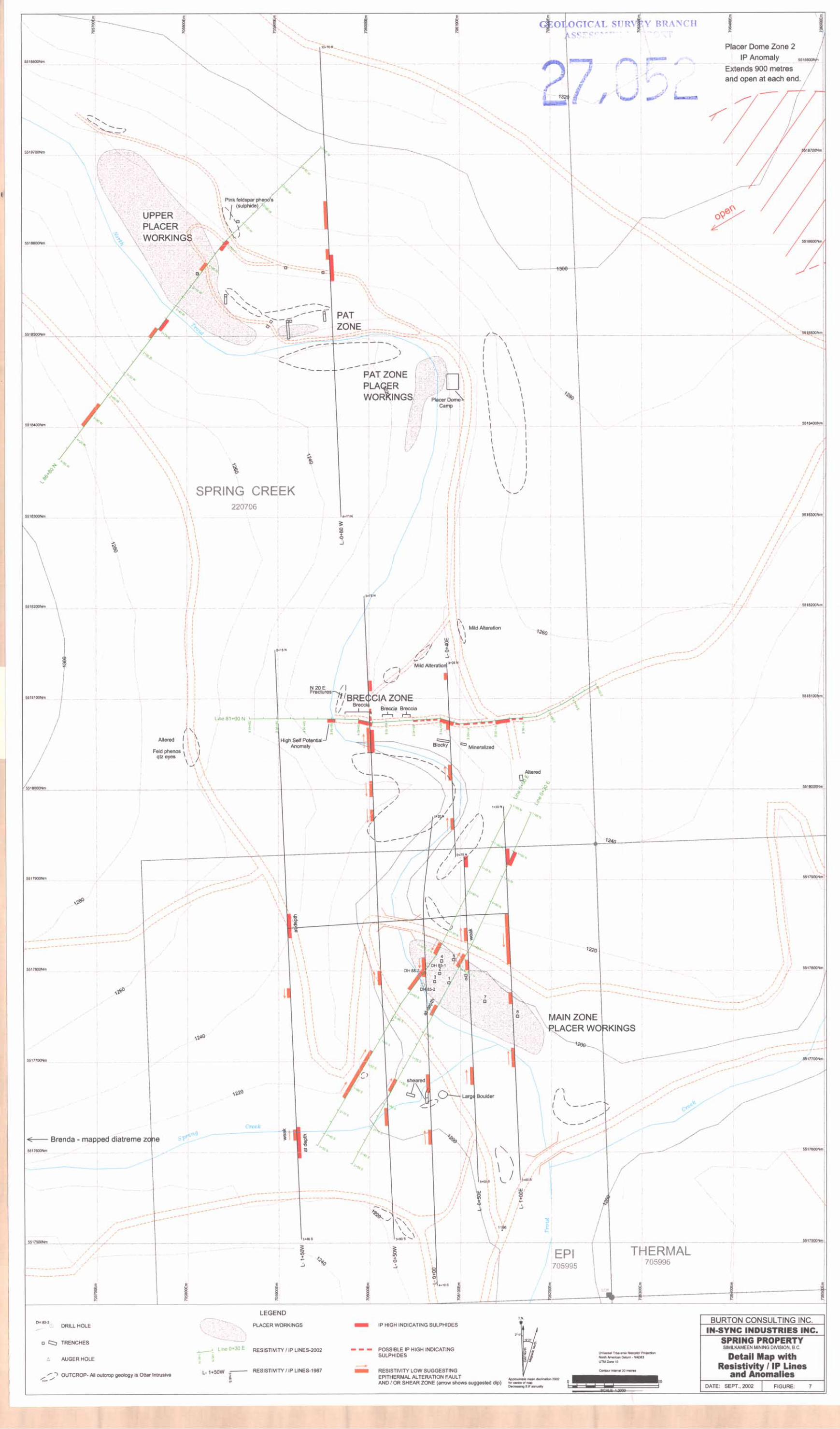
Geology was incorporated onto the property maps at various scales as follows: Figure 4 Location of Alteration Zones at a scale of 1:20,000 Figure 5 Site plan Drill Holes Figure 6 Section Looking West Figure 7 Detail map with Geophysical Lines
Few outcrops were found away from the canyons so the actual area mapped is less than the area surveyed.
Topographic Survey
A large area taken from the 1:20,000 scale topographic map was scanned into a computer and maps at various scales and areas prepared for field use. Figures 3, 4, and 7 were made from the computer scanned data. Total area scanned was 6000 by 5000 metres with the final map 800 by 1300metres. Many points were established with a Trimble Geo - Explorer GPS capable of sub metre accuracy. Poor sky angle of satellites and degree of tree canopy cover denigrated accuracy when stations were in canyons and under heavy tree cover.
Linecutting
Three lines were cut, flagged and surveyed by GPS to great accuracy. Total length exceeded 3,790 metres.
Claims Actuallv Worked On
Work was performed on the Spring Creek (220706), Epi (705995) and Thermal (705996) mineral claims.


4
3. PROPERTY DESCRIPTION and LOCATION
The Spring Property is in the west Okanagan Region of British Columbia, Canada and consists of 225 hectares in area. It is in the Similkameen Mining Division within map NTS 092 H 16 E. Using the new “Trim” claim maps based on North American Datum 1983 on a scale of 1:20,000, it is on map M092H080 within UTM Zone 10.
Co-ordinates are 706253 East and 551745 1 North for the location of the Trout Creek, Epi, Thermal, and Spring Creek Initial Claim Posts as determined by GPS. Several other GPS readings taken on different days were never more than 18 metres difference in position. Elevation taken from GPS readings and NAD 83 topography at the initial posts is 1,197 metres.
The northern corner post for the Epi and Thermal claims, plus the side post (OW, 1N) for the Spring claim are all at 706188E and 55 18003N.
There are three two-post metric claims and one four-post claim of six units for a total of nine units, all contiguous and described as follows:
The work program application for 2002 was approved with the issuance of Annual Work Approval Number RAM 2002 - 1500385 - 052. A reclamation security bond of $2,500.00 in a Safekeeping Agreement has been placed. There are no pre-existing environmental liabilities on the claims.
There are no known mineral resources, mineral reserves or lode mine workings on the claims. There are four areas in the valley floor of North Trout Creek drainage that have been worked for placer gold. These and the known epithermal alteration and mineralized zones are shown on Map Figure 4 entitled “Location of Alteration Zones. Grid lines, trenches, outcrops, claim positions and geophysics are shown on more detailed maps. The Main Zone is on the east side of North Trout Creek slightly upstream from where the Spring Creek joins in. The Pat Zone is just upstream from the Placer Dome campsite. The Diatreme Zone is between the Main and Pat Zones. The Brenda Mines map shows another diatreme zone that starts about 750 metres upstream on Spring Creek from its junction with North Trout Creek. This area has not yet been prospected. The Upper Zone is postulated to be upstream from the Upper placer workings.

5
4. ACCESSIBILITY, CLIMATE. LOCAL RESOURCES, INFRASTRUCTURE and PHYSIOGRAPHY
Accommodation, restaurants and service centres in the Okanagan Valley are handy. A high- tension power line is situated to the north of the property. There are no existing surface establishments in this area. No serious problems are anticipated in the form of water, power, personnel, tailings storage areas, heap leach pads, waste disposal areas or plant sites if a mine were to be developed. Brenda Mines open pit deposit a few kilometres to the northeast was viewed by mine personnel as an attractive place to work.
The summers are pleasant, but the winter snow may be up to two metres deep. Generally the “New” North Trout Creek logging road is kept ploughed for logging trucks during the winter.
The property ranges from 1,100 to 1,500 metres in elevation. It is near the edge of a lobe of glacial till that overlies what is suspected to be a pre glacial plateau at an elevation of roughly 1,220 to 1,240 metres. This plateau is on solid rock. Above this elevation lie lobes of glacial till and fluvial glacial sediments up to an elevation of 1,320 metres, making the thickness of the glacial sediments 80 to 100 metres. Most of the glacial materials are finer silts with few large boulders, except on the top or upper layers of the glacial material where often a layer or horizon of boulders can be seen. The pattern of deposition of the boulders does not appear to be a boulder lag-weathering horizon. Many of these boulders have been dropped to the floor of North Trout Creek and must have been a major problem during placer mining.
Modern North Trout Creek has cut down deeper than the glacial sediments and carved a rock canyon. The present elevation of North Trout Creek is above 1,200 metres in the upper sections and just below 1,200-metre elevation in the lower sections on the property. Where exposed, there are roughly 20 to 40 vertical metres of rock walls in North Trout Creek canyon. Generally North Trout Creek flows south with sharp, almost ninety degree bends mostly to the east, and then the creek returns to its southerly trend. This pattern is repeated at least seven times along the length of the property. At times the canyon of North Trout Creek is narrow with close to vertical rock walls. Talus slopes have developed in places. However, the creek often has a wide flat floor, which can be likened to the start of meanders or ox bows. It is suspected that these wider flat floors to the creek are the result of the creek passing over sheared and also epithermal altered zones. The placer operations were located along these flat portions of the creek. It is logical to think that North Trout Creek had its zig - zag pattern prior to glaciation. Excavator trenching in the upper placer area shows the depth of fill to be six metres above bedrock on this portion of North Trout Creek.
5. GEOLOGICAL SETTING
The Geological Survey of Canada Map 888A, PRINCETON remains the fundamental work on the area. This map sheet was first published in 1947. In the general area of the Spring Property the Okanagan batholith of the Coast intrusions of Jurassic (or Later age) is the primary rock type, but is not found on this property. On the property the main rock type is the Upper Cretaceous or later, Otter Intrusions. Only near the north end of the property in

6
North Trout Creek there is a patch or inclusion of Nicola Group Upper Triassic volcanic% Mapping by Placer Dome in 1987 and 1988 identified a few dykes cutting Otter intrusives. The Otter intrusives have been described by H.M.A. Rice in the Princeton Map 888A as:
“The Otter Intrusions (I 4) appear very different from the Coast intrusions. For the most part they resemble syenites, with a pink to liver colour, and with quartz, if visible, restricted to well formed phenocrysts. Actually they have the composition of granodiorite or granite, but the quartz of the groundmass is in microscopic intergrowths with feldspar and is rarely visible to the naked eye. Everywhere they, or feldspar porphyries abundantly associated with them, cut the Lower Cretaceous formations, but not the Princeton Group, so that their age is either Upper Cretaceous or early Tertiary.”
On the property the Otter intrusions show a wide variety of compositions and grain sizes. Not enough mapping has been done to map contacts between the varieties with large quartz phenocrysts, minor visible quartz and visible quartz free syenites. Some outcrop areas show a regular rectangular fracture set forming talus blocks in what appears to be fresh unaltered Otter while other outcrops do not have the fracture blocks and may be somewhat altered. In some places alteration clays are present which are similar to porphyry or epithermal alteration features.
There is a well-displayed N70”E fracture set in the stream drainage pattern of the general area. It is well displayed in portions of Trout, Spring, Sinem and other smaller creeks. These faults offset the main north - south, or N20”W, fault or fracture sets that most of the creeks occupy. North Trout and Siwash creeks as well as several smaller creeks follow this drainage pattern. The net effect of this is that North Trout Creek flows generally south with left hand offsets at the N70”E faults. This feature is repeated at least eight times on the property. The relationship to the offset faulting and geomorphology in consideration to the glaciation is considered in the Physiography of the property section.
Trenching on the Main Zone, Pat Zone, and on Spring Creek exposed altered and sheared intrusives in the Main Zone and the Pat Zone, and sheared unaltered intrusives in Spring Creek. All three confirm the existence of the N70”E faulting system. On the Main and Pat Zones there is significant epithermal alteration. This alteration is strongest on the south side of the fault on the hangingwall side and gradually decreases in intensity further out into the hangingwall consistent with an epithermal alteration gold system. The footwall rocks are essentially unaltered.
Epithermal gold deposits are known in the Okanagan. One of the most spectacular deposits was the Brett Claims of Huntington Resources Inc. where a reverse circulation hole drilled down dip encountered an average of 2.03 o&on gold over 235 feet. Later diamond drill holes across the structure encountered 0.737 oz/t Au across 17.2 feet, 0.98 oz/t Au across 3 feet, and 0.144 oz/t Au across 10 feet.

Northwest of the Spring Property Almaden Minerals is working on the Elk Property. When it was under the ownership of Fairfield Minerals Ltd. they open pit mined 15,000 tons at 100.6 gr Atme plus another 3,860 ounces of gold from underground workings. According to an article in the August S- 11, 2002 Northern Miner there is a probable underground reserve of 29,838 tonnes grading 28.6 grams gold. There are also indicated and inferred resources. A total of eight veins are known, all hosted in granitic rocks.
Siwash Creek, which is just west of North Trout Creek, contains the closest known mineralization to North Trout Creek. A private report by the author for Golden Pick Resources Ltd., (then called Boomer Resources Inc.) dated October 18, 1985 summarizes the best-known zones of mineralization in the Siwash drainage. The Western Trenches has mineralization in granites cut by two sets of dykes which have veining in the two sets of fractures and also the cross faults consisting of pyrite, sphalerite, galena, chalcopyrite and hematite. This is across a northwest trending zone that could be more than 200 m wide. The Camp Show is in granite, chloritized, carbonated, and brecciated running N70”E with hematite, pyrite, chalcopyrite, galena, and sphalerite. The Three Adit Gap is in a canyon of Otter intrusives and is a wide rusty zone with siliceous veins with good continuity and widths containing pyrite, some chalcopyrite, sphalerite and galena and running in gold and silver. The Spring and Southern Zones are similar to each other. The Southern zone is also similar to the Camp, and the Spring zone is similar to the Western. They have chlorite, dark brown siliceous veining and mineralization of pyrite, chalcopyrite, galena, hematite and possibly mercury. The Spring includes hydrothermally altered rocks and fault gouge. The Agar is a series of discontinuous veins in granite carrying lead and silver plus zinc and copper. The Fisher Maiden was explored by Cominco with an adit on a narrow fault vein of limited extent and width with assays in the 40 - 50 oz Ag/t range. It is not worth further exploration. The Gavin or Elusive Creek has diatremes, epithermal style alteration, and changes in creek direction in the canyon and gold placer gravels. These are all features similar to North Trout Creek where known epithermal systems occur.
The glacial deposits are much less continuous at Siwash Creek so more rock is exposed than around North Trout Creek. It has been suggested that is why more mineralization is known along Siwash Creek
6. MINERALIZATION
The first mineralization discovered on the Spring Property was related to the search for porphyry type deposits. The mining explorationists during the porphyry copper exploration period looked for alteration and quartz veins of the porphyry type and for pyrite, chalcopyrite, plus any molybdenite, as well as hematite, magnetite, and base metals such as galena, and sphalerite. These have all been documented on the Brenda geological map.
No gold bearing veins were known from the earlier phases of exploration. However, considerable gold was produced from placer mining. Agur produced gold that was fresh, clean, shiny and crystalline, without any travel features such as hammering, rounding,
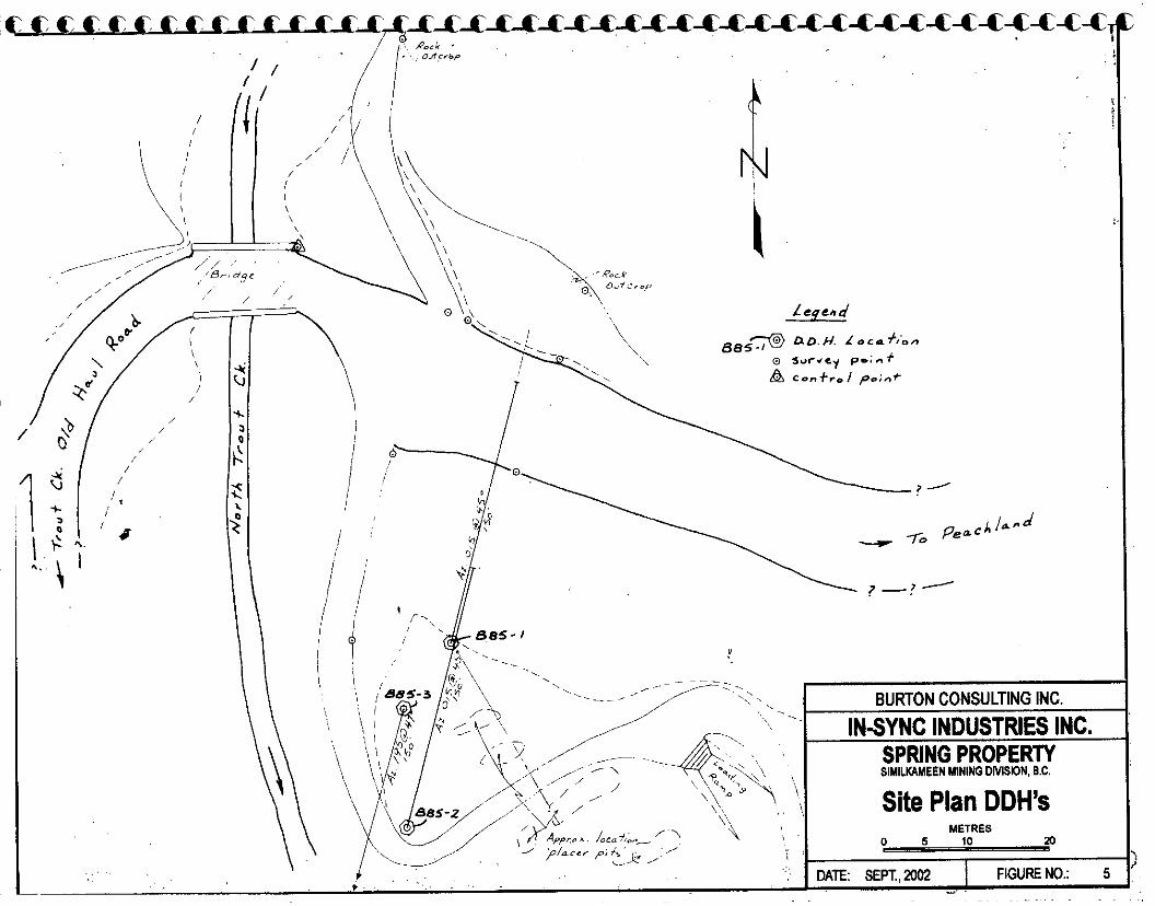
DATE: SEPT.,2302 FIGURE NO.: 5 -.

8
folding, or leached rims. This gold was seen by the author and the only conclusion that one could come to was that the gold had barely been freed from the bedrock within the drainage system. Agur’s opinion was that each section of the creek had its own gold source separate from the other gold sources from each placer area on which he worked along the length of North Trout Creek.
Epithermal alteration zones are known at four places on the property with each zone occurring along the N70”E trend cutting North Trout Creek. The Main Zone is the eastern extension of the Spring Creek Zone with its faulting and diatremes. The next zone north is the Diatreme Zone. The third zone north is the Pat Zone, and the fourth zone north is the Upper Zone.
Other N70”E zones of alteration are evident further upstream along North Trout Creek, but they are less well known and are poorly exposed. The diatreme zone along Spring Creek, which is the western extension of the main zone, has not yet had any exploration. Mapping by Placer Dome shows them to be along the same fault. The Main Zone was drilled with a fence of three diamond drill holes.
During the Golden Pick and Placer Dome exploration periods the target was gold. Two zones of epithermal alteration were discovered by Golden Pick and several more zones with modest gold values were discovered by Placer Dome. The “Diatreme” zones discovered by Brenda Mines are now considered to be breccias developed at the point of strike and dip changes along the faults controlling the epithermal mineralization. The breccias are locally termed rock breccias because they consist of clasts of the country rock embedded in finer ground up fragments of the same rock. They do not have exotic fragments, and usually are healed. The breccias are thought to occur at “knuckle” points where strike changes take place. It is beyond the breccias on the “zig” or the “zag” of the strike where the epithermal alteration extends a significant distance to allow the formation of an oreshoot.
Typical epithermal alteration clays grade out from the hangingwall side of the controlling fault. Usually the strongest alteration is closest to the fault and goes from kaolinite to illite or chlorite to a quartz sericite pyrite hangingwall sequence. When these alteration zones are in andesitic composition volcanics, as many are in Arizona and Nevada, the alteration sequence is well developed and the colour - textural change is easily seen. When the epithermal alteration cuts a typical Otter Intrusive there are fewer reactive minerals so the alteration is more muted, but still recognizable. The topography is not conducive to finding any rock outcrop of these softer alteration zones.
On the Spring property the footwall intrusive rocks on the Main and Pat Zones are well exposed, but the alteration zone has been removed by erosion leaving a lower elevation overburden covered area. It was on the Main Zone area in 1985, when the placer operation was underway, that the excavator bucket at the bottom of its reach to depth brought up white kaolinitic material. That was when the first epithermal zone was identified by F. Marshall Smith, Consulting Geologist. Mr. Agur had dug a pit about 8 meters deep with the upper 5

- ZONE OF EPITHERMAL ALTERATION -
BURTON CONSULTING INC. SILVER MINERALIZATION GREATER THAN 0.1 w/Ton
\
IN-SYNC INDUSTRIES INC. ZINC r0.1 % SPRING PROPERTY
SIMILKAMEEN MINING DMWN, B.C.
NOTE. Section Looking West DIAMOND DRILL HOLES IN TRUE SECTION METRES
0, 5 10 20
DATE: SEPT.,MM FIGURE ND.: 6

9
meters consisting of creek gravels. These overlay a very white clay layer, which Mr. Smith had recognized as kaolinite.
Recent excavator trenches in this zone show intense alteration where the quartz eyes are untouched in a matrix of feldspar phenocrysts and intergrown masses of finer grained feldspars. White clay occurs as blobs and interstitial spots in a matrix of altered feldspars turned largely to green sericite masses. There are patches of pyrite, and occasional blebs of grey copper (tetrahedrite - tennantite?) and sphalerite.
In the diamond drilling done in 1986 by Golden Pick Resources Ltd. on the main Zone, the alteration sequence was strongest next to the fault, which is assumed to strike N70”E and shown to dip close to 70” to the south. In the senior authors experience it is more common to have oreshoots developed on an epithermal fault system either where the dip flattens rather than on the steep portion, or on a short section of strike change. The 1986 drill results are now thought to represent altered ride11 fractures in the hangingwall above the main zone. The recent geophysics and earlier trenching by Agur tend to confirm that the main zone is further south and lower than the earlier diamond drilling. This zone has yet to be drilled and is an attractive exploration target for an epithermal gold system.
The diatreme area to the west of the Main zone along Spring Creek signifies a change of strike of the controlling fault. Good areas for prospecting are on either end of the diatreme zone. The previous term for these fault - breccia zones was diatremes.
The excavator trench on the Pat Zone encountered kaolinitic alteration close to the fault, which gradually changed to more chloritic alteration further out on the hangingwall. Only a small portion of the actual, as opposed to the weathered, fault plane was exposed in the base of the trench, but here also the dip appeared to be steep to the south and the amount of mineralization modest. Along strike to the east from the Pat Zone, Placer Dome discovered argillic alteration on their line 8+00 East, or about 550 metres east of their camp. At this point they also have a widespread I.P. anomaly correlating with some gold soil values.
Along the Diatreme Zone there are apparently disconnected patches of altered intrusive, one zone of moderate mineralization, and three zones of breccia or “Diatreme” material. The Diatreme zone mineralization is at the level of North Trout Creek, although in outcrop is poorly displayed. It is outlined due to a greater precipitation of secondary manganese oxides. Sulphide minerals identified in this showing are pyrite, chalcopyrite plus traces of galena and sphalerite, which occur with magnetite. Prospector Don Agur showed the author a site near the showing where some kind of hole was reported to have been drilled. He did not know who had drilled it or it if it was a diamond drill hole. There is no reported record of this hole.
Regionally on a map the N70”E fault trend seems correct, but in detail fractures in outcrop can vary by up to 30 degrees from this direction. The north - south and N20”W fault system that the creeks follow is regionally correct, but no fault planes have been exposed. The closest to exposed faulting or mineralization occurs in a drainage ditch in the upper placer

10
workings, which are 3 or 4 metres below the valley fill. An excavator trench was dug another 3 metres deep in the bottom of the drainage ditch below water level and encountered fractured bedrock with considerable white clay alteration of the epithermal type. This is the first indication that the north - south faulting may also host epithermal mineralization. Another excavator trench to the west of this one along the west bank of North Trout Creek below the outcrop cliff exposed only fresh, unaltered intrusive from the cliff to the end of the trench close to the creek edge. The main part of the creek bed remains untested. North of this area Placer Dome noted a north - south fault system with some alteration and modest mineralization along a northerly striking dyke.
Within the southwest corner of the property, Placer Dome identified an area called Zone 4 which has soil anomalies for silver, lead, and zinc over an area about 1000 m easterly by 400 m northerly. To the south of this area, another area called Zone M has trench 1010 west in an argillic altered Otter intrusive that ran 300 ppb gold across a 1.5 m sheer zone. Other zones of interest plotted on their general map run from A to S.
More geophysics should outline where the vein faults flatten or where there are strike changes and thus show the best places to do further drilling.
7. EXPLORATION
Exploration work by In-Sync Industries Inc. consisted of collecting and reviewing all the available previous records of work on the property. A map from Brenda Mines, the two volume reports by Placer Dome and the work by Golden Pick was available.
A program of exploration for the lode gold deposits presumed to be the source of the placer gold was prepared for In-Sync Industries Inc. The review, the recommended exploration program, and the fieldwork were carried out and supervised by Burton Consulting Inc. The geophysics was done by Geotronics Surveys Ltd. working with Burton Consulting Inc. The 1987 geophysics, which was also done by Geotronics Surveys Ltd., was digitized in the office to fit with the modern computer program and included in the geophysical data. A local contractor, Frank’s Contracting, did the excavating. A GPS was used to obtain the UTM position of the geophysical stations except those under heavy tree umbrella or below a steep canyon where satisfactory readings on the satellites could not be obtained. GPS readings were also collected for the position of the excavator and auger holes, as well as collecting locations for claim posts, outcrops and features such as roads.
Information was plotted on a 1: 1,000 scale topographic map scanned into the computer from the I :20,000 Trim map. Magnetic north is 18” 44’ east of true north. UTM grid north is 2” 13’ east of true north or 16” 31’ west of magnetic north. Tables of property locations have been prepared and are contained in the appendix. Only short fragments of the previous grid systems can be recognized on the property. In most places there are not enough stations or cut lines identifiable to properly plot each generation of grid lines.

11
Drilling has only been done by Golden Pick Resources Ltd. in 1986 and was done under the supervision of the author. Core recovery was excellent and the logging and sampling was done by the author. The plan and cross section of the three diamond drill holes were prepared by the author at that time and are considered to be accurate and close to true thickness of the zones encountered in the holes.
8. GEOPHYSICS
This section discusses the various types of geophysics that have been carried out over the Spring Property since 1987.
Golden Pick Resources Work - 1987
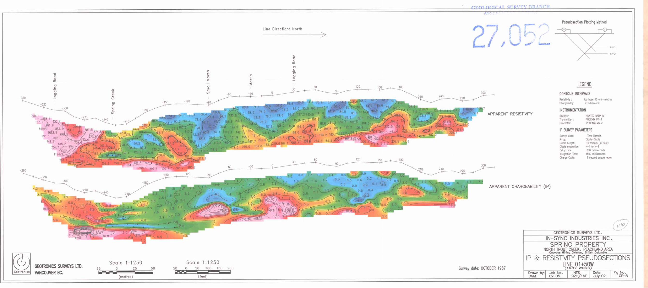
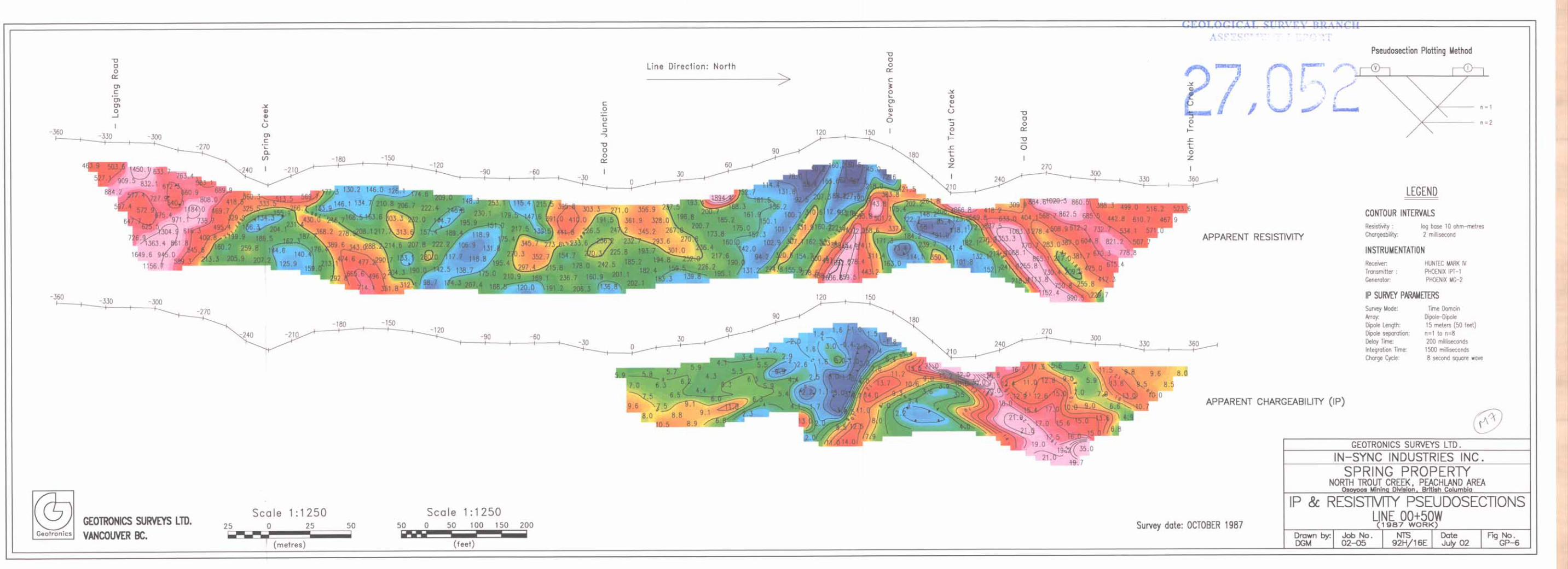
This work consisted of resistivity and induced polarization surveying and was done largely over the Main Zone with some surveying done as well over the Breccia Zone, the Pat Zone and a 30.meter wide alteration zone located over 1500 meters north of the Pat Zone. The work consisted of 3,790 meters and all lines were done in a north-south direction.
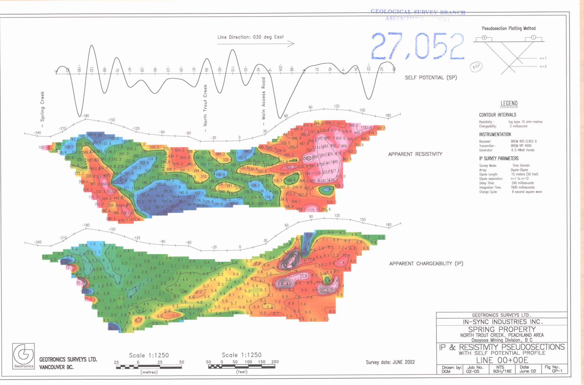
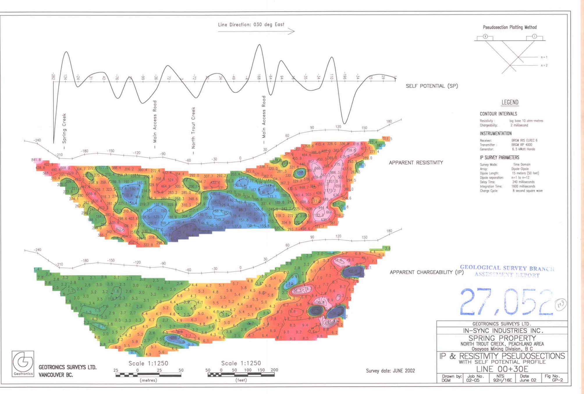
The main purpose was to map, through mainly the resistivity survey, epithermal alteration zones occurring along North Trout Creek. It was intended not only to map the area1 extent, but also the shape and depth extent of the epithermal alteration and, as a result, locate, for optimum drilling purposes, the epithermal veins. It was anticipated that the resistivity survey would reflect the alteration zones as resistivity lows, and, if the epithermal quartz veins were large enough, or showed sufficient contrast, it would also reflect the veins as resistivity highs within the resistivity lows.
Lines O+OOE and 00+30E were carried out using the dipole-dipole array using a dipole length of 10 meters read to 10 separations. The remaining 6 lines were carried out also using the dipole-dipole array but with a dipole length of 15 meters read to 8 separations.
Placer Dome Work - 1988 and 1989
Placer Dome carried out their work over a much wider area since they were looking for a much larger deposit, i.e., large tonnage low-grade gold mineralization. They carried out magnetic and VLF-EM surveying as well as soil sampling over most of the property. The magnetic and VLF-EM surveying totaled 179 km with the magnetic readings taken every 12.5 meters and the VLF-EM readings taken every 25 meters on lines 200 meters apart and fill-in lines 100 meters apart. There were 6,794 soil samples taken every 25 meters on lines 200 meters apart with fill-in soil sampling done on lines 50 or 100 meters apart. The samples were tested for gold, copper, lead, zinc, and silver.
Placer Dome also carried out 15 km of IP and resistivity surveying over selected areas. These were done with a pole-dipole array using a 25-meter dipole read to 4 separations.

12
In-Sync Industries Work - 2002
The geophysics that Geotronics carried out for In-Sync earlier this year consisted of 1,800 meters of resistivity/IP surveying and essentially was a continuation of Golden Pick’s 1987 work. The purpose, through the resistivity surveying, was to determine whether the strike and dip of the epithermal alteration zones were different than that suggested by the 1987 survey, as well as to explore to a greater depth.
All surveying was done using the dipole-dipole array with dipole lengths of 15 meters read to 12 separations. This gives a theoretical depth penetration of about 100 meters. Two lines were done across the Main Zone in a direction of N30”E. one across the Breccia Zone in a direction of approximately due west, and one across the Pat Zone in a direction of S5O”W.
In the exploration for epithermal veins, IP surveying can be useful but not nearly to the degree that resistivity surveying is. It will reflect sulphides, usually pyrite, that occurs within the outer ring of the alteration zone, that is, on the hanging wall side of a resistivity low. When the resistivity/IP surveying was done in 1987, the IP receiver used was single channel and non-memory. As well, all data reduction and map work was done by hand without the benefit of computers. As a result, most of the IP readings were not plotted or contoured because of the minimal benefit to the exploration of epithermal mineralization. In fact, for two of the lines, O+OOE and 00+30E, the IP readings were not even taken.
Therefore, in order to plot the IP readings, as well as to bring the 1987 survey up to date to make it more useable, its data was digitized so that it could be computer plotted and contoured. This also enabled the 2002 work to be interpreted more accurately.
The 1987 and 2002 surveying was done on the following lines and to the following lengths.
IPI -R 1987 Examine 30-meter alteration zone
37n m GP-19

13
The total amount of IP and resistivity surveying carried out for 2002 was 1,800 m. The total amount of 1987 data that was digitized and computer-plotted and contoured was 3,790 m. This gives a total of 5,590 m.
9. DISCUSSION OF RESULTS
Main Zone
The resistivity survey has revealed a number of resistivity lows across this zone that for the most part are very likely reflecting the kaolinitic alteration that is known to exist within the Main Zone. It has been seen in the trenching, pits, and diamond drilling carried out in this area. The resistivity lows trend westerly and occur in two sets, one within the northern part of this zone and one within the southern part.
The southern one occurs along Spring Creek and is the strongest and largest resistivity low within the property. It indicates that the causative source dips northerly in a stepped fashion and increases in intensity with depth. This suggests that the alteration increases with depth. Epithermal veins always occur along the footwall of the alteration zone, which is caused by hydrothermal gases rising and altering the rock within the hangingwall above the vein. Therefore, this is considered to be a prime exploration target.
The JP readings are somewhat stronger within the hangingwall, which, in the author’s experience, is typical of epithermal systems. The somewhat higher IP readings reflect an increase in pyritization.
The northern resistivity low within the Main Zone shows both northerly and southerly dips and is not nearly so strong and wide as is the southern one. This zone may simply be a ride11 off of the main mineral zone or perhaps a parallel but weaker zone.
An IP anomaly is shown to occur to the north of the Main Zone and to the south of the Breccia Zone. It is likely a reflection of sulphides, which are known to occur throughout the property. Sulphides that have been noted and mapped by Placer Dome geologists as well as the senior author are pyrite, chalcopyrite, galena, and sphalerite.
Breccia Zone
The resistivity survey has revealed several anomalous lows in this area mainly on lines 00+5OW and 00+4OE. These appear to more likely be reflecting faulting because of the shape.
What is interesting, however, is the number of IP highs, which, as mentioned above, are strongly indicative of sulphides. In addition, on the 2002 cross line, 81+OON, there is a very strong SP anomaly that occurs on North Trout Creek. This is probably reflecting a sulphide vein. The Breccia Zone therefore may be of exploration interest especially if enough

14
economic sulphides can be located. It is of minimal interest, however, for epithermal gold veins.
Pat Zone
The resistivity lows in the area of the placer workings indicate any possible epithermal alteration is weak and/or shallow. It seems unlikely therefore that the source of the gold is in this area. Perhaps it occurs just upstream from the placer workings.
The IP survey has revealed highs on both the 00+8OW and 86+80N lines that indicate sulphides occur on the creek bottom and on the north slope.
30-Meter Alteration Zone
This zone occurs about 500 meters to the north of the Pat Zone. A short line was done across this zone in 1987. which at that time was labeled IPL-8.
The resistivity pseudosection shows this zone located at about 00+3OS, to be weak and
narrow, certainly narrower than 30 meters, which simply may be an apparent width. It probably dips to the north. Correlating with the footwall of this zone is an IF’ high that is indicative of sulphides.
The low within the southern part of the pseudosection located at l+ 0% is reflecting a fault with an apparent dip to the north.
Placer Dome GeoDhvsics
For the purposes of this report, the results of the Placer Dome geophysics is of limited exploration interest since their focus was on a larger tonnage, lower grade deposit. However, they did come up with targets, and further work, including drilling, was recommended. A summary is given as follows.
The magnetometer survey aided in the mapping of biotite hornblende quartz diorite, granite pegmatite, and quartz-biotite gneiss. It also mapped regional lineaments trending in both 070”E and 150”E.
The VLF-EM survey showed a number of strong conductors with a predominant direction of 060”E and several offsets trending 010”E. There was little correlation with the soil geochemistry results but there was correlation with some of the known fault systems suggesting this to be the main causative source. There was also correlation with some of the IP anomalies.
Soil geochemistry anomalies in all five metals occur throughout the property and are too numerous to discuss here. Zone 4, as mentioned above, is the largest of these anomalies. A number of these are gold anomalies and eventually need to be followed up on.
15
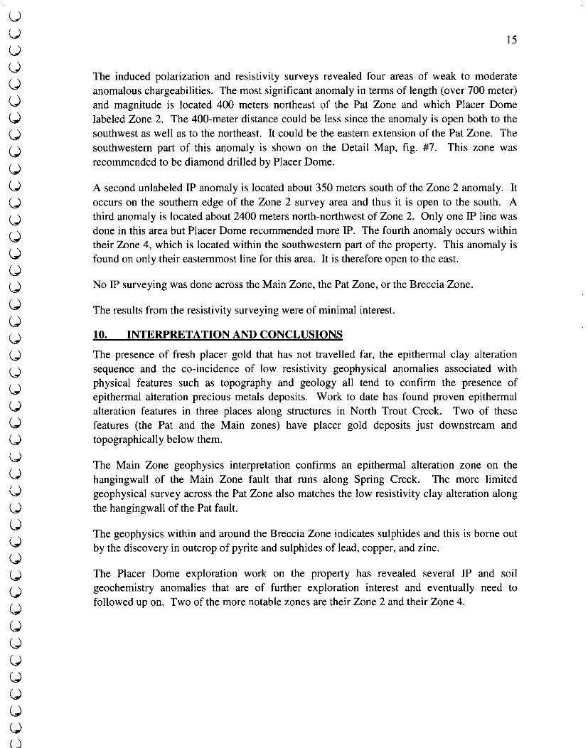
The induced polarization and resistivity surveys revealed four areas of weak to moderate anomalous chargeabilities. The most significant anomaly in terms of length (over 700 meter) and magnitude is located 400 meters northeast of the Pat Zone and which Placer Dome labeled Zone 2. The 400-meter distance could be less since the anomaly is open both to the southwest as well as to the northeast. It could be the eastern extension of the Pat Zone. The southwestern part of this anomaly is shown on the Detail Map, fig. #7. This zone was recommended to be diamond drilled by Placer Dome.
A second unlabeled IP anomaly is located about 350 meters south of the Zone 2 anomaly. It occurs on the southern edge of the Zone 2 survey area and thus it is open to the south. A third anomaly is located about 2400 meters north-northwest of Zone 2. Only one IP line was done in this area but Placer Dome recommended more IP. The fourth anomaly occurs within their Zone 4, which is located within the southwestern part of the property. This anomaly is found on only their easternmost line for this area. It is therefore open to the east.
No IP surveying was done across the Main Zone, the Pat Zone, or the Breccia Zone
The results from the resistivity surveying were of minimal interest.
10. INTERPRETATION AND CONCLUSIONS
The presence of fresh placer gold that has not travelled far, the epithermal clay alteration sequence and the co-incidence of low resistivity geophysical anomalies associated with physical features such as topography and geology all tend to confirm the presence of epithermal alteration precious metals deposits. Work to date has found proven epithet-ma1 alteration features in three places along structures in North Trout Creek. Two of these features (the Pat and the Main zones) have placer gold deposits just downstream and topographically below them.
The Main Zone geophysics interpretation confirms an epithermal alteration zone on the hangingwall of the Main Zone fault that runs along Spring Creek. The more limited geophysical survey across the Pat Zone also matches the low resistivity clay alteration along the hangingwall of the Pat fault.
The geophysics within and around the Breccia Zone indicates sulphides and this is borne out by the discovery in outcrop of pyrite and sulphides of lead, copper, and zinc.
The Placer Dome exploration work on the property has revealed several IP and soil geochemistry anomalies that are of further exploration interest and eventually need to followed up on. Two of the more notable zones are their Zone 2 and their Zone 4.
16
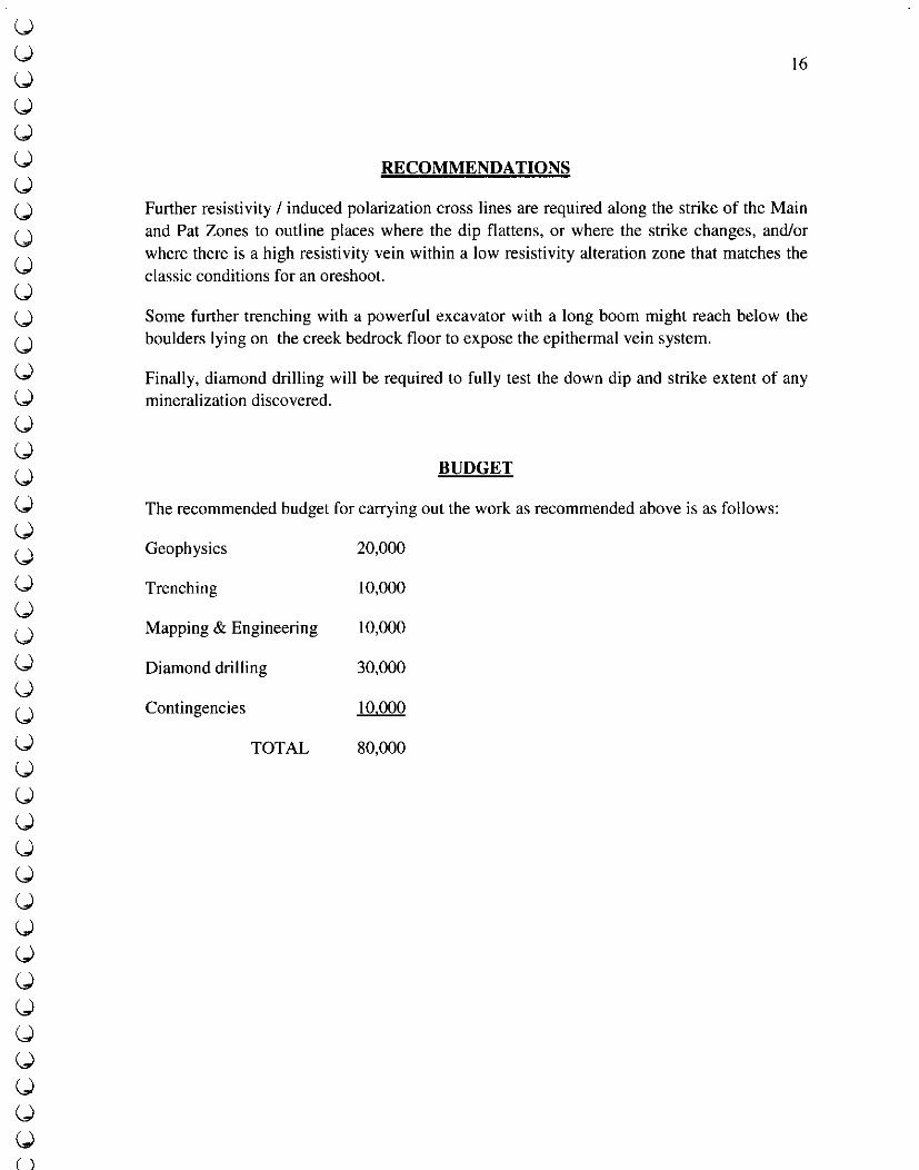
RECOMMENDATIONS
Further resistivity I induced polarization cross lines are required along the strike of the Main and Pat Zones to outline places where the dip flattens, or where the strike changes, and/or where there is a high resistivity vein within a low resistivity alteration zone that matches the classic conditions for an oreshoot.
Some further trenching with a powerful excavator with a long boom might reach below the boulders lying on the creek bedrock floor to expose the epithermal vein system.
Finally, diamond drilling will be required to fully test the down dip and strike extent of any mineralization discovered.
BUDGET
The recommended budget for carrying out the work as recommended above is as follows:
Geophysics 20,000
Trenching 10,000
Mapping & Engineering 10,000
Diamond drilling 30,000
Contingencies 10.000
TOTAL 80,000

COST STATEMENT
Initial Trenching program
Fees to A Burton, P. Eng. May 03,28, June 14 to 19,2002 6 days @ $450 Fees to helper D Javorsky June 14 - 19,6 days @ $250 Vehicle June 14 to 19,6 days Saw, 2 radios, sample bags, expendibles G.S.T. on items* Franks excavating, June 17,‘18,2002 Meals, gas, expenses Motel June 14 to 19 Trim maps, drafting, base map preparation Auger drill rental June 14 to 19
2,700.00* 1500.00 608.40* 140.00* 241.38
1,658.50 583.23 28 1.75 863.15 130.55
Induced Polarization and Resistivitv Survey (June 26 to July 2,2002)
Meals and gas 4X4 rental, June 26 to July 2 GPS rental, 2 days @ $30 A Burton, P. Eng., fees June 26 to July 2, 2002 GST on items * Geotronics Surveys Ltd. 5 man crew, 5 days, with vehicle, room & board
243.04 624.40*
60.00* 3,150.00*
268.41 14,109.02
Second Trenchiw Program, August 5 to 9.2002
Gas, Groceries, Meal 205.03 Helper, (D Howland) Aug 6,7 270.00 Franks Contracting (excavater Aug. 7, 8, 2002) 1,369.60 Differential GPS, two days 1 oo.oo* 4X4 rental Aug 5 to 9,2002 382.80* Fees, A Burton, P. Eng. 4 days + 2 hours 1,950.00* GST on * items 172.05
Data reduction and report preparation. August 15 to Sept. 2002
Geodrafting 1,478.34 Geotronics Surveys Ltd, 2,963.OO Burton Consulting Inc. 2,963.OO TOTAL $39,015.65
17

18
REFERENCES
Brownlee, D. J. Private Report, for Golden Pick Resources Ltd., Feb. 12, 1988 Burton, Alex, Summarv Report, Sorinn Prooertv, for Boomer Resources Inc., Sept.1985 Burton, Alex, Summarv Report, Trout and Siwash Properties. for Boomer Resources Inc., Oct.1985 Burton, Alex, Drilling Assessment Report, Sprint ProoertL for Boomer Resources Inc., July I, 1986 Burton, Alex, Private Report. Trout Creek Prooertv. for Boomer Resources Inc., Sept. 1985 Burton, Alex, Private Report, Trout Creek Prooertv, for Boomer Resources Inc., Aug 21, 1986 Burton, Alex, Private Reoort, for Boomer Resources Inc., Sept.9, 1986 Burton Alex, Mark David, Report on the Spring Property, for In Sync Industries Inc.
Sept. 2002 Deschenes; Marc, Cannon, Richard; Letient, Henri; Pease, Robert; Propertv and Assessment Report for the 1989 Work Program on the Sorine Proaertv (Venture 2321, Placer Dome Mines Ltd., December 1989 Mark, David, Geophvsical Report over a Portion of the Spring Property, 1987 Pease, Robert; Deschenes; Marc, Cannon, Richard; 1988 Work Program Report, Spring Property, Placer Dome Mines Ltd., August 1989 Smith, F Marshall, Private Report for Boomer Resources Inc. May 10, 1985 Unknown, Field map of Trout Creek, Brenda Mines Ltd. date unknown
19
GEOPHYSICIST’S CERTIFICATE
I, DAVID G. MARK, of the City of Surrey, in the Province of British Columbia, do hereby certify that:
I am registered as a Professional Geoscientist with the Association of Professional Engineers and Geoscientists of the Province of British Columbia.
I am a Consulting Geophysicist of Geotronics Surveys Ltd., with offices at 6204 - 125’h Street, Surrey, British Columbia.
I further certify that:
I am a graduate of the University of British Columbia (1968) and hold a B.Sc. degree in Geophysics.
I have been practicing my profession for the past 34 years, and have been active in the mining industry for the past 37 years.
This geophysics part of this report is compiled from data obtained from resistivity and IP surveys carried out over a portion of the Spring Property during October, 1987, and during June, 2002. The surveys from both dates were under my supervision. Not under my supervision but discussed with this report was all work done by Placer Dome during 1988 and 1989
I do not hold any interest in the Spring Property, nor in any other property held by In-Sync Industries Inc. of Vancouver, British Columbia, nor do I expect to receive any as a result of
David G. Mark, P.Geo. Geophysicist January 2003
20
CERTIFICATE OF AUTHOR
I, Alex Burton, P. Eng., P. Geo. Consulting Geologist, hereby certify that:
I have a consulting office at 1408 Seventh Avenue, New Westminster, B. C., Tel/Pax: (604) 525-8403, e-mail: [email protected]
I am a graduate geologist from the University of British Columbia in 1953. I am registered as both an Engineer and Geologist with the Association of Professional Engineers and Geoscientists of B.C., #6262. I am a Life Member of both the Canadian Institute of Mining and Metallurgy and the Association of Geoscientists for International Development. I am also a founding member of the Association of Exploration Geoscientists and am a qualified geochemist for the purposes of this instrument. I have practiced my profession for over fifty years, both as an exploration manager for major international mining companies and as an independent consultant. As a result of my experience and qualification I am a Qualified Person as defined in N. P. 43 - 10 1.
I was personally present during the trenching, and geophysical surveying on the Thermal, Epi, Trout Creek, and Spring Creek Claims during the summer of 2002. I am responsible for this report except for the parts on the geophysics provided by Mr. David Mark.