Embed Size (px)
Citation preview
Tier II FEIS Transportation Page 3-349
SR 167 – Puyallup to SR 509 22- 3.14 Transportation 061031.doc
3.14 Transportation
3.14.1 Studies Performed and Coordination
The Tier I FEIS analyzed the transportation element of SR 167. Year 1990
traffic volumes were used for the existing condition. The Tier II EIS has been
updated with year 2000 existing traffic volumes.
Studies documenting the transportation-related impacts of the proposed corridor
included: traffic forecasts, analyses of traffic operations on the freeway, truck
transportation analysis, arterial and local street systems, and evaluation of
transportation safety. Bicycle and pedestrian facilities are discussed in Section
3.15. The project has a limited effect on other modes of transportation, including
transit and rail so specific studies of these elements were not required.
Traffic Data
Existing transportation conditions were analyzed using several methods and data
sources. Traffic volume counts and intersection turning movement data for the
area south of I-5 were obtained from the Washington State Department of
Transportation (WSDOT) and the City of Fife. Traffic counts were obtained
from WSDOT, the City of Tacoma and City of Fife for the area north of I-5,
including counts for the existing SR 509. WSDOT provided mainline and ramp
traffic counts for I-5. Local traffic data for the existing roadway system,
including truck routes, was obtained from WSDOT, City of Tacoma, City of Fife,
City of Milton, and City of Puyallup.
Traffic Forecasts
Traffic forecasting for transportation projects is usually done for two time
periods, the year the project will be opened and fully operational (year of opening
2015) and twenty years after construction is scheduled (the Design Year 2030).
For the Tier II EIS, the year of construction was established to be 2010 and the
design year established to be 2030 due to the magnitude of the project.
Two forecasting tools, the Puget Sound Regional Council (PSRC) and Pierce
County EMME/2 Travel Demand Forecast Models (2001), were used in
developing the 2030 traffic forecasts. Both models utilize the traditional four step
modeling process: trip generation, trip distribution, mode split, and traffic
assignment. The models use the 2030 land use, social economic, and
transportation networks as input.
The PSRC model was developed to forecast Average Daily Traffic (ADT), AM
and PM peak three hours, transit, high occupancy vehicle (HOV) and commuter
rail passenger volumes. Since it has a regional focus, its traffic analysis zones
(TAZ) are relatively large and the model networks include only major regional
facilities. As a result, the model is able to generate more reasonable forecasts for
major regional freeways, but the local surface street output for the network is
fairly crude. The Pierce County model has a finer TAZ structure and includes
more local roads, thus it is able to provide more reasonable forecasts for the local

Page 3-350 Transportation Tier II FEIS
22- 3.14 Transportation 061031.doc SR 167 – Puyallup to SR 509
transportation networks. The drawback of this model is that it does not have a
calibrated AM peak hour model.
Since FHWA and WSDOT’s standard practice is to analyze both AM and PM
peak hour traffic, both models were used to generate more confident traffic
forecasts for both peak periods. Most mainline volumes did not vary between
AM and PM peak hour volumes, but some of the on-off ramps showed
substantial differences between the two.
2030 Land Use Data
The initial 2030 land use data were developed by PSRC as a working draft for
updating the PSRC’s 2030 Metropolitan Transportation Plan. For the PSRC
model, this set of data was used without modifications. For the Pierce County
model, the regional land use forecast was reviewed and refined by Pierce County
staff. The refinements, with PSRC’s control total remaining fixed, were made to
more accurately reflect the most recent housing growth trend and the potential
developable lands available.
2030 Network Data
In order to represent the future transportation systems, both the PSRC and Pierce
County models assumed completion of HOV lanes on I-5, existing SR 167, and
SR 512. The PSRC model also reflected the completion of Canyon Road and the
commuter rail from Seattle, via Puyallup, to Tacoma.
The traffic forecasts include AM and PM peak hour general purpose as well as
HOV trips for the roads, freeway ramps, and intersections in the study area.
According to the WSDOT long-range HOV policy and consistent with the PSRC
Metropolitan Transportation Plan (PSRC 2001), HOV occupancy is defined as
three people and above per vehicle in the year 2030.
Traffic Operations Analysis
Year 2000 and 2030 volumes were used for analysis of existing and design year
traffic operations, respectively. Capacity and level of service (LOS) calculations
for intersections and freeways were based on the 2000 Highway Capacity
Manual (HCM) (WSDOT 2000). The SR 167 Tier II EIS Traffic Report covers
the analysis in more detail (WSDOT 2001a).
The LOS concept uses qualitative measurements that characterize operational
condition (speed, travel time, freedom to maneuver, traffic interruptions, comfort,
and convenience) within the traffic stream. There are six levels of service: LOS
A represents free-flowing traffic, LOS B represents reasonably free-flow
conditions, LOS C provides for stable operations (but flows approach the range
in which small increases in flow will cause substantial deterioration in service),
LOS D borders on unstable flow, LOS E describes operation at capacity, and
LOS F describes unstable flow or stop and go conditions.
Both isolated and closely spaced or coordinated signal systems were analyzed
using Synchro traffic software. The traffic forecast models described above were
used to generate volumes (total vehicles per hour for each movement) required
for analysis. LOS calculations for unsignalized intersections are based on the

Tier II FEIS Transportation Page 3-351
SR 167 – Puyallup to SR 509 22- 3.14 Transportation 061031.doc
delay for each stop-controlled movement not for the overall intersection. LOS
was computed using Highway Capacity Software. For urban or suburban areas,
the reserve capacity at LOS D is considered to be acceptable. Lower levels of
service (LOS E or LOS F) indicate that the traffic on side streets will experience
unacceptable delays.
3.14.2 Affected Environment
The project’s study area is bounded by the proposed SR 167/SR 509 interchange
to the west, the I-5/SR 18 interchange to the north, the SR 167/SR 410
interchange to the southeast, and the I-5/ Port of Tacoma Road Interchange to the
southwest. The transportation network within the study area is illustrated in
Figure 3.14-1.
Existing Freeway Network
The study area is served by I-5, the primary north-south freeway route on the
West Coast, and a number of principal, minor and collector streets as shown in
Figure 3.14-2. I-5 serves as the principal north-south arterial in the Puget Sound
region. North of the study area, SR 18 provides the link to I-90 and destinations
east.
Within the project area, I-5 consists of four travel lanes in each direction.
Interchanges are provided at Portland Avenue/Bay Street (the connection to the
existing SR 167 via River Road), Port of Tacoma Road and 54th Avenue East.
70th Avenue East and Porter Way bridges cross over I-5.
I-705 provides a freeway connection between I-5 and downtown Tacoma. It
branches off of I-5 west of the Puyallup River, on the western edge of the project
area, and extends north with interchanges at South 21st Street, South 15th Street,
and South 11th Street.
SR 509 provides east-west access to the Port of Tacoma as well as northeastern
Tacoma. Currently, a four-lane facility is in operation from I-705 to Port of
Tacoma Road.

Page 3-352 Transportation Tier II FEIS
22- 3.14 Transportation 061031.doc SR 167 – Puyallup to SR 509
Figure 3.14-1: Regional Highway System

Tier II FEIS Transportation Page 3-353
SR 167 – Puyallup to SR 509 22- 3.14 Transportation 061031.doc
Figure 3.14-2: Local Roadway System

Page 3-354 Transportation Tier II FEIS
22- 3.14 Transportation 061031.doc SR 167 – Puyallup to SR 509
The southeastern portion of the project study area is served by the SR 512/SR 161
and SR 167 freeways. Both these facilities currently terminate in the vicinity of
North Meridian, immediately north of the Puyallup River. SR 167 provides the
following connections:
• SR 410 freeway to Bonney Lake
• SR 410 to Yakima via Cayuse/Chinook Pass and/or White Pass
• SR 18 in Auburn connecting to I-90 west of North Bend
• I-405 in Renton
The Auburn to Renton section of the SR 167 freeway serves a major regional
distribution and employment center. The SR 512 freeway provides access from
Puyallup to I-5 in Lakewood. WSDOT is responsible for the operation and
maintenance of all freeways within the project area.
Existing Surface Streets
North of I-5, the arterial network has not been fully developed. Port of Tacoma
Road and 54th Avenue East provide direct routes between I-5 and the Port of
Tacoma. North of Port of Tacoma Road, SR 509 (East 11th Street) has not been
developed into a limited access freeway.
In general, the arterial network is not well developed south of I-5. Through traffic
between the SR 167 and SR 512 freeways and I-5 or the Port of Tacoma and
Tacoma central business district areas is routed onto either Valley Avenue or
existing SR 167 on River Road between these points. A high percentage of truck
traffic from the east is forced to use these routes to access the Port. This traffic, in
combination with locally generated traffic, results in high traffic demands on the
existing local system.
Non-freeway arterial routes operated by WSDOT include East 11th Street (SR 509),
Pacific Highway (SR 99), River Road (SR 167), and North Meridian (SR 161).
Phase 1 of the SR 509 East-West corridor project built a four-lane freeway from
Pacific Avenue to Milwaukee Way. The second phase of this project is not yet
funded for completion. It will extend the four-lane freeway in the parkway median
from Milwaukee Way to north of Taylor Way, with grade separations at Alexander
Avenue and Taylor Way. Since the Tier II DEIS was published, the City of
Tacoma, Pierce County, and Port of Tacoma staff have coordinated the closure of
Alexander Avenue north of SR 509.
River Road (SR 167) is a five-lane principal arterial, functioning as the link between
I-5 in Tacoma and the existing SR 167 freeway near Puyallup. Pacific Highway is a
four-lane principal arterial east of 54th Avenue East managed by WSDOT. West of
54th Avenue East, it is a city street owned by the City of Tacoma. North of Valley
Avenue East, North Meridian (SR 161) is a two lane minor arterial that serves as a
route to I-5 in Federal Way north from Puyallup.

Tier II FEIS Transportation Page 3-355
SR 167 – Puyallup to SR 509 22- 3.14 Transportation 061031.doc
Principal arterials that are operated by Pierce County or other local jurisdictions
include 54th Avenue East, Pacific Highway East, 70th Avenue East, Valley Avenue
East and Port of Tacoma Road. Valley Avenue East is an existing two-lane road
(with four lanes between Freeman Road East and North Meridian) connecting the
cities of Fife and Puyallup. North of 24th Street East, this route continues as 54th
Avenue East, which has been widened to three lanes south of I-5 and five lanes
north of I-5, where it provides access to the Port of Tacoma. The principal existing
access route to the Port from I-5 is Port of Tacoma Road, a five-lane surface street.
The City of Fife is currently making capacity improvements to the Port of Tacoma
Road/Pacific Highway intersection.
Other locally maintained minor arterial streets within the project area include 20th
Street East, 54th Avenue East (south of Valley Avenue), North Levee Road East,
and Freeman Road East. These streets are generally two lanes wide. As adjacent
land is developed, continuous center two-way left turn lanes have been constructed
on these streets. At present numerous gaps remain.
Existing (2000) Traffic Volumes
Selected average daily traffic volumes on the freeways and streets within the project
area are displayed on Figure 3.14-3. These volumes are based on traffic counts
conducted by the jurisdiction operating the various facilities. Where year 2000 data
is not available, the traffic volumes were estimated by applying growth factors to
earlier counts. The project traffic data will be reviewed and updated as necessary in
the design phase of the project development.
Roadway Capacity
Most existing capacity restrictions are in the vicinity of principal arterial
intersections or freeway interchanges. Freeway mainline and interchange
operations as well as key intersections on the surface street system are explained
below.
Freeways
In the year 2000, traffic studies undertaken by WSDOT provided data used to
analyze existing freeway operations.
I-5 operates at 65 mph during the AM and PM peak hours, with the exception of
southbound (SB) PM, which operates at 60 mph. Traffic flow on I-5 through the
study area is within acceptable levels during the AM/PM peak hours, except
southbound PM peak hour.
The SB I-5 exit ramps serving traffic to Fife at Port of Tacoma Road and 54th
Avenue East interchanges operate at LOS C and LOS F respectively.

Page 3-356 Transportation Tier II FEIS
22- 3.14 Transportation 061031.doc SR 167 – Puyallup to SR 509
Figure 3.14-3: Existing (2000) Average Daily Traffic Volumes (ADT)

Tier II FEIS Transportation Page 3-357
SR 167 – Puyallup to SR 509 22- 3.14 Transportation 061031.doc
Surface Streets
The capacity of the local roadway system is generally controlled by both signalized
and unsignalized intersections. Those intersections nearest existing interchanges on
I-5 and at the terminus of the freeway section of SR 167 experience the highest
levels of peak-period traffic demands near or over their capacity. Figure 3.14-4 and
Table 3.14-1 show existing (year 2000) PM peak hour operations at key
intersections.
The existing SR 167 route between SR 161 and I-5 is on surface streets through the
City of Puyallup via North Meridian and River Road. Several intersections operate
at over-capacity conditions during peak periods resulting in traffic backups and
delays. High traffic volumes on River Road result in poor levels of service for
traffic turning out of side streets, particularly at higher-volume locations such as the
intersection of River Road and Pioneer Way. WSDOT continues to make
operational improvements to decrease traffic delay.
An alternate route from SR 161 to I-5 winds through Fife via Valley Avenue and
54th Avenue East. The proximity of intersections on 54th Avenue East near I-5
combined with high truck volumes, high turning volumes, and inadequate lane
configurations; result in delays for traffic passing through these intersections.
The intersections at 54th Avenue East and I-5 northbound (NB) and I-5 SB
ramps operate at LOS F. The intersection of 54th Avenue East and 20th Street
East operates at a LOS E. WSDOT completed some signalization and
channelization modifications in the 1990s, which improved intersection
operations temporarily, until traffic volumes increased.
The City of Fife has made capacity improvements to Valley Avenue and 54th
Avenue East. The City of Puyallup has widened Valley Avenue to four lanes
between SR 161 and Freeman Road. The City of Fife is currently designing the
widening of Valley Avenue to four lanes between Freeman Road and 70th
Avenue East.
Intersections in the vicinity of the Port of Tacoma Road interchange on I-5 are
similarly experiencing traffic demands near or greater than their capacity. The
intersections with SR 99 and with 20th Street East operate at LOS E and LOS F
respectively. WSDOT has made several attempts to improve operations with
signal timing adjustments, but traffic volumes are continuing to increase. The
high volume of trucks (30 to 40 percent daily on Port of Tacoma Road) that use
the interchange further add to this problem (WS LTC 1996).

Page 3-358 Transportation Tier II FEIS
22- 3.14 Transportation 061031.doc SR 167 – Puyallup to SR 509
Figure 3.14-4: Existing (2000) P.M. Peak Hour Level-of-Service

Tier II FEIS Transportation Page 3-359
SR 167 – Puyallup to SR 509 22- 3.14 Transportation 061031.doc
Table 3.14-1: Study Area Intersections - Level of Service
INSERT TABLE FROM EXCEL
Intersection Locations 2000 No-Build Build
Port of Tacoma Road and 20th Avenue F F F
Port of Tacoma Road and NB 5 on/off ramp B F E
Port of Tacoma Road and SB 5 on/off ramp C F F
Port of Tacoma Road and SR 99 Signal E F F
Port of Tacoma Road and NB SR 509 Signal B N/A B
Port of Tacoma Road and SB SR 509 Signal B N/A D
Alexander Avenue and SR 99 Signal C C C
Alexander Avenue and NB SR 509 Signal C F N/A
Alexander Avenue and SB SR 509 Signal C F N/A
54th Avenue and Valley Avenue B F B
54th Avenue and 20th Avenue Signal F F C
54th Avenue and NB 5 on ramp (SB left and NB right from 54th) F F F
54th Avenue and NB 5 off ramp (to SB 54
th Avenue) D F F
54th Avenue and SB 5 on/off ramp Signal F F B
54th Avenue and SR 99 Signal D F F
54th Avenue and 12th Street Signal A D C
54th Avenue and SR 509 Signal B F F
54th Avenue and SR 167 on ramp Future Signal N/A N/A A
54th Avenue and SR 167 off ramp Future Signal N/A N/A B
SR 99 and Porter Way Signal D F C
SR 99 and 70th Avenue Signal B F F
70th Avenue and 20
th Avenue Signal D F B
70th Avenue and Valley Avenue Signal C F F
70th Avenue and North Levee Road B C B
Pioneer Way and SR 512 WB ramps Signal B C B
Pioneer Way and SR 512 EB ramps Signal B B B
66th Street and existing SR 167 Signal F F F
66th Street and North Levee Road F No Data No Data
Freeman Road and 20th Avenue Signal No Data No Data No Data
Freeman Road and Valley Avenue F F F
82nd and North Levee Road A E B
Meridian Avenue and River Road (existing SR 167) Signal C F F
Meridian Avenue/ NB at city street B F F
Meridian Avenue and SR 167 Signal F F D
Meridian Avenue and Valley Avenue Signal C F F
Meridian Avenue and SB at North Levee Road Signal C F F
Valley Avenue and SR 167 NB ramps Future Signal N/A N/A A
Valley Avenue and SR 167 SB ramps Future Signal N/A N/A A
Year 2030
Alternatives

Page 3-360 Transportation Tier II FEIS
22- 3.14 Transportation 061031.doc SR 167 – Puyallup to SR 509
Transportation Safety
The Tier I FEIS accident data analysis sufficiently reflects the safety conditions
on the existing freeway and local street system. As identified in the Tier I EIS,
severe congestion and inadequate intersection geometry on both networks
continues to attribute to areas with high accident rates.
Existing SR 167(River Road) Collision Data
The following is a summary of the collisions on the River Road segment of SR
167. This data is for the time period January 1, 2003 through July 31, 2006:
SR 167, I-5 to Puyallup City Limits (MP 0 to MP 5.23)
Year # Collisions Collision Rate Statewide Rate
2003 102 2.06 2.41
2004 86 1.67 2.36
2005 147 2.75 2.56
(2006 Thru July 31, 2006 there have already been 82 collisions)
Further analysis on I-5 has been completed in preparation of the Access Point
Decision Report required by Federal Highway Administration. Several locations
on I-5 Ramps within the project study limits have been identified as High
Accident Locations (HAL) in 2002:
• NB On Ramp at existing SR 167
• SB Off Ramp at Port of Tacoma Road
• NB Off Ramp at 54th Avenue East
• NB Loop Off Ramp at 54th Avenue East
• SB Off Ramp at 54th Avenue East
Heavy volumes of traffic, geometrics that do not meet current standards, and
interchange-related congestion are the primary contributing factors to the
accidents. This project and other Core HOV projects will correct some of the
geometric deficiencies. As for the congestion related accidents, the proposed
SR 167 project will provide relief with the addition of the SR 167/54th Avenue
East Interchange.
The HAL safety locations listed herein were addressed in some manner during
the 2003-2005 biennium. WSDOT is required to study those locations,
identifying how best to reduce the number and severity of accidents. WSDOT
often uses the application of appropriate Transportation System Management
Strategies described in Section 3.14.5 to relieve congestion, thus lowering
accidents.

Tier II FEIS Transportation Page 3-361
SR 167 – Puyallup to SR 509 22- 3.14 Transportation 061031.doc
The statewide accident rate (number of accidents per million vehicle miles) for
urban interstate is 1.60 based on the 1996 Washington State Highway Accident
Report (WSDOT 1996). The 1999-2000 accident rate for I-5 south of 54th
Avenue East (including ramps) is 1.02 and north of 54th Avenue East is 0.76,
both well below the statewide averages.
Port, Rail, and Transit Facilities
Major regional non-highway transportation facilities and services exist within the
project area and are described below. These facilities include the Port of
Tacoma, numerous railroad operations, and transit service providers. Both Pierce
Transit and Sound Transit provide express regional commuter services.
Port of Tacoma
The Port of Tacoma generates large volumes of traffic and the facility will
benefit from the improved connections to I-5 and completion of SR 167
extension to the Port. In recent years the Port of Tacoma has become one of the
major container ports on the West Coast, serving as a transfer point from rail to
ship for cargo destined for Pacific Rim ports from Midwest, East Coast, and
European origins (and vice-versa). Containerized cargo with origins or
destinations in the Northwest is trucked from the Port, resulting in high numbers
of container hauling trucks in and out of the Port on the regional highway system.
Other activities that also generate large volumes of truck traffic include: auto
handling, log handling, break-bulk, and dry-bulk facilities. Land use in Fife will
also complement the Port area with warehousing and industrial complexes
nearby.
The Port is participating in the Freight Action Strategy Corridor program which
is a regional effort to increase the efficiency of moving freight and people in and
around Puget Sound. A result of that effort is the recently completed Port of
Tacoma Road overpass of SR 509 and new railroad tracks that run parallel to
SR 509.
The 1997 removal of the 11th Street Bridge has created opportunities for growth
in the Blair Waterway area. The Port has recently completed the Blair Waterway
dredging and has plans to further widen the Waterway. The dredging and
widening are both elements of the Port of Tacoma 2020 Master Plan. The
Puyallup Tribe of Indians also owns property on the Waterway and is jointly
working with the Port to develop the Waterway property. The plan will allow the
development of a world-class container terminal facility.
Rail Operations
The project area is served by two intercontinental railroads and a local short line
railroad. Existing rail lines provide passenger and freight service between the
Seattle-Tacoma and the Portland metropolitan areas. The Port of Tacoma
generates a large volume of rail traffic. Goods transported by rail, destined for
other Pacific Rim ports from Midwest, East Coast and European origins (and
vice-versa), are transferred between rail and ship at the Port of Tacoma.
Tacoma Rail, an operating division of Tacoma Public Utilities, switches freight
between the two intercontinental railroads and Tacoma industries. Its customers

Page 3-362 Transportation Tier II FEIS
22- 3.14 Transportation 061031.doc SR 167 – Puyallup to SR 509
include the Port of Tacoma. Tacoma Rail also has a maintenance-servicing track
for CEECO. Tacoma Rail provides service 24 hours a day, seven days a week.
The Tidelands Division has 38 miles of track located north of SR 509.
The Burlington Northern Santa Fe (BNSF) Railroad operates between Seattle and
Tacoma on a double track mainline, which continues south to Vancouver,
Washington. Between Seattle and Tacoma, it passes through the cities of
Tukwila, Renton, Kent, Auburn, Pacific, Sumner and Puyallup. Approximately
60 freight trains operate daily on the line. The Amtrak Coast Starlight and
Cascade runs also uses the mainline eight times daily for passenger service
through Seattle and Tacoma. The BNSF mainline is located on the south side of
the Puyallup River. The BNSF track serving the Port of Tacoma is located west
of Port of Tacoma Road. Neither track is directly affected by the project.
The Central Puget Sound Regional Transit Authority Sound Transit commuter
rail commuter service established in September of 2000 operates four daily
commuter runs on the BNSF mainline. This service currently averages more
than 3,000 passengers daily between Seattle and Tacoma, passing through the
Port area.
The Union Pacific Railroad (UPRR) mainline operates a single track through the
southern portion of the project area. The mainline tracks are part of the UPRR
Seattle to Tacoma mainline. Railroad yard facilities are located south of I-5, in
the vicinity of Frank Albert Road. South of Tacoma to Portland, Oregon, UPRR
trains operate on BNSF tracks. Approximately 16 trains each day use the Seattle
to Tacoma mainline. With the exception of Valley Avenue and Frank Albert
Road, local arterial streets cross the railroad at grade. Railroad officials continue
to stress that all additional crossings within the project area will require grade
separation designs. (WSDOT Rail Division Office 2001b)
Transit
The project lies within the Pierce County Public Benefit Area and Sound Transit
(ST) service boundary. Pierce Transit provides bus service within this area.
Local routes connect Tacoma and Fife with Federal Way, Puyallup, and Milton
areas. Pierce Transit and ST also operate express bus service on I-5, connecting
Tacoma with Lakewood and Seattle. The Tacoma Dome Station, a 2400 stall
facility, serves as a transportation hub for local transit service and regional
express service connections for ST express bus service. The Station also serves
as destination for ST commuter rail Seattle/Tacoma connection. Greyhound and
Northwestern Trailways Bus terminal with services to Seattle and Portland via
I-5 are also located in the vicinity. The following local transit routes operate in
the study area:
• Route 65 between downtown Tacoma to points south of Valley Avenue i.e.,
45th Court East via Milwaukee Way, 20th Street East, 70th Avenue East and
Valley Avenue
• Route 402 between Federal Way, Puyallup, and Graham via SR 161 and
North Meridian

Tier II FEIS Transportation Page 3-363
SR 167 – Puyallup to SR 509 22- 3.14 Transportation 061031.doc
• Route 490 South Hill to Tacoma express via Pioneer Way East
• Route 500 between downtown Tacoma to Federal Way via Pacific Avenue
and 20th Street East
• Route 501 between downtown Tacoma to Federal Way, via 20th Street East
Express bus service is provided in the I-5 corridor to SeaTac airport and
downtown Seattle, downtown Tacoma, and Olympia. The following routes pass
through the study area:
• Express Route 574 between the Lakewood Transit Center, Tacoma Dome
Station to SeaTac Airport via I-5
• Express Route 582 between Bonney Lake to downtown Tacoma express via
River Road
• 590 between downtown Tacoma, Tacoma Dome Station to Seattle via I-5
• 591 between Lakewood, Tacoma Dome Station to Seattle via I-5
• 592 between DuPont, Lakewood to Seattle via I-5
• 594 midday and weekends between Lakewood, downtown Tacoma, Tacoma
Dome Station to Seattle via I-5
• 595 between Purdy, Gig Harbor, Narrows Park and Ride, Tacoma
Community College to Seattle via I-5
Pierce Transit began direct Pierce County to Seattle express transit service in
1990. Sound Transit commenced service between Seattle and Tacoma in 1999.
ST service is currently operating from the Lakewood park and ride lot in the
vicinity of SR 512/I-5 interchange, Tacoma Community College, Kimball Drive
via SR 16, downtown Tacoma and the Tacoma Dome Station. Extended
Regional service connections are also operating from the Intercity Transit
Olympia downtown station via I-5. ST opened a new transit station in DuPont in
February 2003. The ST long-range vision for electric light-rail includes the
possibility of a future high-capacity transit corridor running south along I-5
through SR 167.
Park and Ride Lots
Alternative 2 of the Tier I FEIS suggested the possibility of locating a park and
ride lot within the project’s acquired right-of-way in the area of I-5/SR 167.
Preliminary park and ride lot site findings have determined that the area lacks
adequate property and direct freeway access and will not be further considered.
In 1989, Pierce Transit began studies to locate a park and ride lot in north Pierce
County between downtown Tacoma and King County. A 1990 effort indicated a
need for roughly 2,800 stalls along the I-5 corridor from Federal Way south.

Page 3-364 Transportation Tier II FEIS
22- 3.14 Transportation 061031.doc SR 167 – Puyallup to SR 509
A January 2001 WSDOT Puget Sound Park and Ride System Update report
indicated a corridor level demand for year 2020 as follows:
• I-5 Central park and ride lots (I-5 Tacoma North) 960 to 1,060 stalls
• Valley park and ride lots (SR 167/Sumner Station and Puyallup Station) 730
to 930 stalls combined.
The SR 167 Tier I FEIS proposed upwards of 1,500 stalls be established within
the project corridor. The report recommended a 500-stall site in the vicinity of
SR 167/SR 161 interchange and a 1,000 stall lot along the I-5 corridor.
Pierce Transit has recommended the addition of two park and ride lots in the
project corridor: one in the vicinity of the southwest quadrant of the Valley
Avenue Interchange and one southwest of the Valley Avenue and SR 161
Intersection (Pierce Transit 2002). These two recommended park and ride lot
locations have been included in this FEIS.
Pedestrian and Bicycle Facilities
Pedestrian and bicycle facilities are covered in more detail in Section 3.15. The
discussion herein summarizes some details relating to transportation.
Pedestrian facilities within the project area are limited. With exceptions of the
local street system in the city of Fife, sidewalk facilities are relatively nonexistent
or discontinuous. Gaps in existing facilities are being filled in as adjacent land is
being redeveloped from agricultural to commercial, or industrial uses. Pedestrian
use of the existing facilities is light, due to the relatively low density of existing
land uses and the lack of adequate pedestrian facilities.
Bicycle facilities are also relatively undeveloped within the project area. The
completion of SR 509 affords the experienced bicyclist a substantial east-west
corridor in lieu of the permanent bicycle prohibition on I-5. The cities of Fife,
Milton, Edgewood, and Puyallup transportation plans do identify a multitude of
facility improvements for bicycle travel. Existing bicycle activity in the project
area is light, again due to relatively low land use densities and a lack of safe and
desirable facilities along existing roads. Complete bicycle route information is
contained in the Pedestrian and Bicycle Discipline Report. The project will
accommodate the Interurban Trail and re-establish the public access connection
to the trail in the vicinity of 70th Avenue East and I-5. The relocated portion of
the trail will be ADA accessible, a separated Class I or II non-motorized path
linking to the City of Fife pedestrian and bicycle facilities. The Interurban Trail
is a recreational 4(f) facility and additional information is included in subsection
5.4.2 of this FEIS.
Nearly all of the project’s mainline shoulders would serve to create a new travel
corridor for experienced bicycle riders. A separate multiuse path is planned
north of SR 167 approximately from 54th Avenue East Interchange to SR 99.
Traffic volumes, ramp movements and vehicle speeds create unsafe conditions
on the I-5 Interchange facility and on southbound SR 167 between 54th Avenue
East and SR 509 and warrant a bicycle prohibition through these segments of the
project.

Tier II FEIS Transportation Page 3-365
SR 167 – Puyallup to SR 509 22- 3.14 Transportation 061031.doc
Long-range local transportation plans identify pedestrian and bicycle facility
route improvements. The improvements are essentially beyond the constrained
funding levels of local municipalities that would serve to increase pedestrian and
bicycle mobility opportunities. Local roadways intersecting the project will
accommodate pedestrian travel based on WSDOT design practices and local
jurisdiction roadway design.
3.14.3 Impacts of Operation
Year 2030 traffic forecasts have been developed for the No Build and Build
Alternatives to determine the effects of the project on traffic circulation. These
forecasts help determine congestion and level of service impacts, capacity and
circulation changes, and potential safety impacts associated with each alternative.
Impacts on Port of Tacoma, railroad, transit, pedestrian and bicycle facilities
have also been studied.
No Build Alternative
Completion of SR 509 and the regional HOV lane projects represent the only
major changes to the regional highway system with the No Action Alternative.
Several changes to the surface street system are planned by local jurisdictions:
widening Pacific Highway, 54th Avenue East, and Valley Avenue within the city
of Fife; widening Valley Avenue between North Meridian and Freeman Road
East; and the completion of Canyon Road which has yet to be funded.
Traffic Projections
Within the project study area, large traffic volume increases are expected to
occur between year 2000 and 2030. Rezoning by the city of Fife has led to a
rapid land use shift from agriculture to light industrial and manufacturing. Figure
3.14-5 displays projected year 2030 average daily traffic volumes on the local
roadway system. (Included in the projections are the planned surface street
improvements listed above.) With the No Build Alternative, the largest traffic
increases would occur on the surface street system as more development in the
Puyallup Valley leads to more vehicles on the local system.
Total traffic generated within the Tacoma Tideflats area (between
Commencement Bay and I-5) is forecast to increase from a 1996 daily total of
63,300 auto and truck trips to 105,400 daily trips in 2020. This represents a
growth rate of about 2.1 percent per year (WS LTC 1996). Substantial increases
in traffic will occur on Pacific Highway (SR 99), where daily traffic volumes are
forecast to increase from 24,200 to 43,000 (nearly 77 percent) from year 2000 to
2030. Daily traffic volumes on I-5 through the project area are forecast to
increase 32 percent over existing year 2000 levels, from 163,000 to 214,500 in
year 2030.
On the local street network, traffic volumes on River Road and Valley Avenue,
both of which function as connectors between the end of the SR 167 freeway and
I-5, would be expected to nearly double between the year 2000 and 2030. Near
70th Avenue East, River Road volumes are anticipated to increase from 30,000 to
44,000 and Valley Road from 11,780 to 22,000. Substantial traffic increases

Page 3-366 Transportation Tier II FEIS
22- 3.14 Transportation 061031.doc SR 167 – Puyallup to SR 509
I-5 Section 2000 Existing 2030 No Build 2030 Build
Northbound AM PM AM PM AM PM
Puyallup River to Port of Tacoma Road
D D F F F F
Port of Tacoma Road to 54th Avenue East
D C E D D D
54th Avenue East to SR 167 (proposed)
D C F D C C
SR 167 (proposed) to SR 18 F E
Southbound
SR 18 to SR 167 (proposed) D F
SR 167 (proposed) to 54th Avenue East
C E C F C C
54th Avenue East to Port of Tacoma Road
D D C E C D
Port of Tacoma Road to Puyallup River
D F C F D F
would also occur on North Levee Road as well as SR 161 (North Meridian)
(Figures 3.14-3 and 3.14-5). Directional Design Hourly Volumes predicted for
the No Build Alternative in 2030 are presented in Figure 3.14-6.
Congestion and Traffic Operations Impacts
With the projected growth in traffic and a relatively small number of capacity
improvements, congestion of freeway and surface street facilities would be
expected to increase with the No Build Alternative. On I-5, the mainline level of
service during peak periods is expected to drop to LOS E or LOS F in some
sections in the year 2030. I-5 in the study area will be particularly congested
northbound in the morning and southbound in the evening peak periods. Some
improved LOS would be realized during the No Build SB AM peak hour; this is
due to the planned HOV lane addition included in the modeling (Table 3.14-2).
Under the No Build Alternative, many surface street intersections within the
project area would experience traffic demands greater than their capacity,
operating at LOS E or LOS F (Table 3.14-1).
Table 3.14-2: I-5 Peak Hour Level of Service
Tier II FEIS Transportation Page 3-367
SR 167 – Puyallup to SR 509 22- 3.14 Transportation 061031.doc
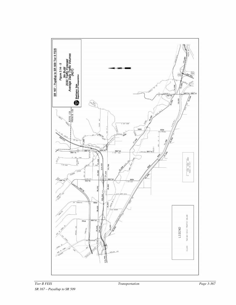
Figure 3.14-5: No Build 2030 Traffic Forecast – Average Daily Traffic Volumes (ADT)
Page 3-368 Transportation Tier II FEIS
22- 3.14 Transportation 061031.doc SR 167 – Puyallup to SR 509
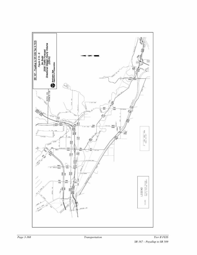
Figure 3.14-6: No Build 2030 Traffic Forecast – Directional Design Hourly Volume (DDHV)

Tier II FEIS Transportation Page 3-369
SR 167 – Puyallup to SR 509 22- 3.14 Transportation 061031.doc
Circulation Changes
North of I-5, the principal traffic circulation changes are associated with SR 509.
Trucks exiting the Port of Tacoma have access to southbound I-5 via SR 509 and
I-705. Those trucks traveling east or north can access I-5 northbound via the
recent improvements on the Port of Tacoma Road. However, those improvements
moved the existing congestion problems from the railroad tracks to the I-5 ramp
intersections at Port of Tacoma Road. As quoted previously, truck traffic
accounts for 30 to 40 percent of the traffic on Port of Tacoma Road (WS LTC
1996). Drivers are now seeking alternative routes via SR 99 and 54th Avenue
East Interchange to avoid the congestion.
South of I-5, increased congestion levels on the existing highway and street
system would likely lead to increased volumes on secondary routes. To avoid
congestion on River Road and Valley Avenue, drivers would seek out alternative
routes on North Levee Road, 54th Avenue East and 70th Avenue East.
Safety Impacts
As traffic volumes increase on the I-5 and local street system, the number of
accidents would also increase. The influx of the number of trucks using the
surface street system could increase the severity of the accidents occurring due to
increased congestion. The accident rates at current problem areas, such as on I-5
ramps or along River Road would likely increase.
Impacts on Port, Railroad and Transit Facilities
The No Build Alternative would not provide any additional access to the Port of
Tacoma from the regional freeway system, particularly to the north via I-5 or east
via SR 167, which in turn connect to SR 18 and I-90. Substantial growth in Port-
generated truck traffic could be expected to increase congestion on routes leading
to and from the Port facilities. The additional time required to access the Port
could increase shipping times.
The No Build Alternative would not seriously affect railroad facilities. However,
more rail traffic and more truck traffic at crossings would result in longer delays
and decreased safety at at-grade crossings.
Without the extension of SR 167 freeway between North Puyallup and I-5, there
would not be an opportunity to connect the planned I-5 HOV facilities with SR
512 and SR 167. Transit routes would experience congestion without designated
lanes for travel.
Impacts on Bicycle Travel
The No Build Alternative, as it relates to the existing local roadway system and
the non-motorized user, would continue the degradation of non-motorized travel
options, alternatives and mobility opportunities. The increased traffic volumes
associated with the no build alternative would further lessen safety and livable
community aspects for non-motorized users. Under the No Build scenario, no
major improvements would be made to the existing local roadway facility
network within the project area other than those that would be made by the local
jurisdictions.

Page 3-370 Transportation Tier II FEIS
22- 3.14 Transportation 061031.doc SR 167 – Puyallup to SR 509
Build Alternative (Preferred)
The SR 167 freeway will be extended from its current terminus at North
Meridian (SR 161) to I-5 and tie into SR 509. Interchanges will be provided at
54th Avenue East, I-5, Valley Avenue and SR 167. The proposed alignment and
interchanges are described in more detail in Chapter 2 of this document. The
other improvements discussed in the No Build Alternative will also be
constructed: SR 509, widening SR 99, the widening of several surface streets,
and the completion of Canyon Road when funding occurs.
Traffic Projections
Projected average daily traffic volumes for the freeways and local surface
network are displayed in Figure 3.14-7. Between I-5 and SR 509, the new
freeway segment will carry approximately 42,000 vehicles per day (vpd); from I-
5 to SR 161, about 100,000 vpd. The predominant traffic movements at the SR
167 and I-5 Interchange will be to and from the north, followed by traffic to and
from the south. Predicted Directional Design Hourly Volumes for the Build
Alternative are shown in Figure 3.14-8.
On I-5, traffic volumes will decrease compared to the No Build conditions
between Port of Tacoma Road and the new I-5 interchange (Figure 3.14-5 and
Figure 3.14-7). The decrease is due to several changes in regional traffic
patterns: the proposed SR 167 provides more direct access to the Port of Tacoma
and SR 509; southbound SR 167 traffic that previously diverted to SR 512 will
remain on the freeway to directly tie in to southbound I-5; local Puyallup Valley
commuter traffic will be able to access the freeway system via SR 167, forgoing
circuitous routes through Milton and Edgewood.
The existing alternate routes on River Road and Valley Avenue will also
experience volume reductions.
Capacity Changes
Chapter 2 describes the SR 167 Build Alternative in detail. To summarize: The
build alternative will provide a six-lane freeway (two general purpose lanes and
one HOV lane in each direction) between the existing freeway terminus and I-5.
Four lanes will continue northwest to tie into SR 509. At the I-5 interchange,
direct freeway connections are planned for the SR 167 general-purpose lanes as
well as the HOV lanes. The Preferred Loop Option interchange will be provided
north of I-5 at 54th Avenue East. Two full interchanges are planned at both
Valley Avenue and North Meridian.
Locally, the City of Fife is planning to widen Valley Avenue to four lanes. 70th
Avenue East will be reconstructed from the existing two lanes to five lanes.
Additional capacity improvements are occurring on 20th Street East, and Milton
Way due to tremendous growth in the Puyallup Valley. The City of Puyallup
plans to tie the proposed North Canyon Road into 70th Avenue East in the
vicinity of Valley Avenue, but currently there is no funding.
Tier II FEIS Transportation Page 3-371
SR 167 – Puyallup to SR 509 22- 3.14 Transportation 061031.doc
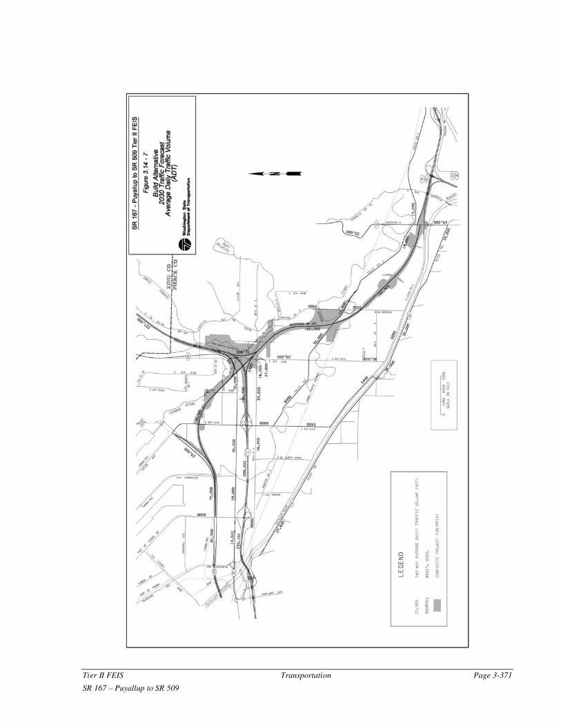
Figure 3.14-7: Preferred Build Alternative 2030 P.M. Peak Traffic Forecast - Average Daily Traffic Volume (ADT)

Page 3-372 Transportation Tier II FEIS
22- 3.14 Transportation 061031.doc SR 167 – Puyallup to SR 509
Figure 3.14-8: Preferred Build Alternative 2030 P.M. Peak Traffic Forecast - Directional Design Hourly Volume (DDHV)

Tier II FEIS Transportation Page 3-373
SR 167 – Puyallup to SR 509 22- 3.14 Transportation 061031.doc
Congestion and Traffic Operations Impacts
Peak-period congestion levels on I-5 will be somewhat better than those that will
occur with the No Build Alternative. I-5 will operate at LOS F south of the
existing SR 167 Interchange and north of the proposed interchange during the
PM peak period. There will be improved level of service on the I-5 segments
between the existing SR 167 Interchange and proposed SR 167 interchange
(Table 3.14-2).
The proposed SR 167 freeway will operate at LOS D or better between I-5 and
SR 161 (North Meridian) interchanges (Table 3.14-3). Approximately 100,000
vehicles per day will be able to travel through the proposed route unencumbered.
Some congestion (LOS D) was identified to occur between North Meridian and
SR 512, but an auxiliary lane is planned to relieve the congestion.
Table 3.14-3: SR 167 Peak Hour Level of Service
Circulation Changes
Freeway Network
Major circulation changes will occur with the completion of the SR 167
extension project. The regional freeway network will gain a valuable connection
for truck traffic traveling from the Port of Tacoma to the north via I-5 or east via
SR 167 to I-90. SR 167 traffic previously diverting to SR 512 to access I-5 south
will have a more direct route to I-5. Substantial traffic reductions are expected on
I-5 between the SR 167, 54th Avenue East, and Port of Tacoma Road
interchanges as Port of Tacoma traffic is diverted to SR 509 and SR 167.
Drivers may opt to use SR 167 as an alternate north-east option, decreasing
congestion on the north I-5 to SR 18 route to I-90 east.
Local Roadway Network
Drivers on the local roadway system will be provided access to SR 167 at Valley
Avenue with the preferred option. Truck volumes in existing residential areas
near 54th Avenue East will be reduced. In addition to 2030 reduced traffic
2030 AM 2030 PM
SR 167 Northbound
SR 509 to 54th Avenue East B C
54th Avenue East to I-5 C C
I-5 to Valley B C
Valley to Meridian C D
Meridian to SR 512 C D
SR 167 Southbound
SR 512 to Meridian D C
Meridian to Valley D C
Valley to I-5 C C
I-5 to 54th Avenue East C C
54th Avenue East to SR 509 B C

Page 3-374 Transportation Tier II FEIS
22- 3.14 Transportation 061031.doc SR 167 – Puyallup to SR 509
volumes, the improvements planned by the City of Fife and the City of Puyallup
will improve capacity and operations of the local system.
The complexities of the SR 167/I-5 interchange design led to the realignment of
20th Street East. The current alignment of 20th Street East could not be
accommodated with a bridge over proposed SR 167. Instead, vehicles will take a
more circuitous route with two roundabouts to the intersection with 70th Avenue
East, which accesses the area north of I-5 (Figure 3.14-9).
Safety Impacts
Construction of the Build Alternative is expected to reduce the number of
accidents within the corridor by providing a safer facility with full-access control.
Year 2030 congestion levels at many key intersections will be lower than the No
Build Alternative, which should result in a reduced number of accidents
occurring at these intersections.
Impacts on Port, Railroad, and Transit Facilities
The Build Alternative will greatly improve traffic traveling to and from the Port
of Tacoma. The northbound I-5 access will be more direct via SR 167 with free-
flowing conditions. Port traffic to Eastern Washington can remain on SR 167 to
access I-90 via I-405 or SR 18 in Kent, avoiding the steep grade portion of SR 18
near I-5.
One railroad crossing is planned over the UPRR line just south of the planned
Valley Avenue Interchange. Minimal delays may occur during construction.
Construction activities will be coordinated with UPRR officials to minimize
disruptions through SR 167 construction areas.
Transit facilities will be improved in the Build Alternative. Pierce Transit has
recommended two park and ride lot locations in the project area. The build
alternative includes construction of freeway HOV lanes to connect from I-5 to
SR 161 (North Meridian).
The project will improve travel times for transit using the proposed HOV lanes
and direct connect ramps between I-5 and proposed SR 167. Some impacts to
transit headways will be anticipated during construction and temporary detours.
Coordination with Pierce Transit will be critical in limiting headway times due to
detour and/or intermittent traffic stops.
One alternative for a wetland mitigation site is on UPRR property located south
of their tracks, west of Frank Albert Road, and north of North Levee Road. This
location will have the potential to accommodate some wetland mitigation as well
as future UPRR yard facility expansion south of the rail line. WSDOT, City of
Fife, UPRR, and Port of Tacoma staff will continue to coordinate efforts in the
development of this site.

Tier II FEIS Transportation Page 3-375
SR 167 – Puyallup to SR 509 22- 3.14 Transportation 061031.doc
Figure 3.14-9: Realignment of 20th Street

Page 3-376 Transportation Tier II FEIS
22- 3.14 Transportation 061031.doc SR 167 – Puyallup to SR 509
Truck Routes
WSDOT studied the effect of the Build Alternative on the movement of trucks on
city of Fife surface streets. The three existing truck routes studied in detail are
shown in Figure 3.14-10.
Build conditions show an improvement in travel times for trucks using the three
routes. Table 3.14-4 summarizes the findings.
Table 3.14-4: City of Fife Truck Travel Time Improvements
Impacts on Pedestrian and Bicycle Travel
Pedestrians and bicyclists will experience limited temporary impacts during the
project’s construction. Special attention should be paid to safely accommodate
pedestrians and bicyclists during times when the normal travel routes are
disrupted.
The closure of the SR 167 mainline to bicyclists between SR 99 and 20th Street
East, and southbound SR 167 between 54th Avenue East and SR 509, will
require possible improvements to the local city roadway systems to accommodate
safe and expeditious bicycle travel through the area (See additional discussion
Section 3.15).
Summary of Traffic Conditions without the SR 167 Extension Project
The project traffic horizon year is 2030. It is expected that by 2030 the level of
service (LOS) throughout the project area would be poor due to population
growth, including the SR 167 Extension project. However, without the SR 167
Extension project (No-Build Alternative) in the year 2030, congestion and LOS
on I-5 and other adjacent roadways would be substantially worse.
Currently, the only east-west routes are local streets that travel through
commercial districts and neighborhoods. Because of the proximity to the Port of
Tacoma, the truck traffic in this area is extremely heavy and, consequently, the
local streets are very congested. The SR 167 project will allow the trucks to
arrive and leave the Port of Tacoma through a limited access route and stay off
the local street system. This will improve the congestion and safety on the local
streets considerably. With or without the SR 167 project, this area will continue
to experience heavy traffic volumes because the area contains the Port of
Tacoma, as well as several commercial businesses and retail stores.
No Build (min) Build (min) Time Improvement (min)
Route 1 56.7 10.7 46
Route 2 104.8 26.8 78
Route 3 62.8 11.8 51
New SR 167 (NA) 5.8 (NA)

Tier II FEIS Transportation Page 3-377
SR 167 – Puyallup to SR 509 22- 3.14 Transportation 061031.doc
Figure 3.14-10: Truck Routes

Page 3-378 Transportation Tier II FEIS
22- 3.14 Transportation 061031.doc SR 167 – Puyallup to SR 509
3.14.4 Mitigating Measures
No Build
Development will continue to escalate in the Puyallup Valley as the area moves
away from its agricultural base to an area zoned for light industrial and
manufacturing uses. Currently, I-5 operates at over capacity conditions north of
the project area. The surface street system also operates at over capacity
conditions on Valley Avenue, 54th Avenue East and 70th Avenue East and at
several key intersections. Truck traffic on residential streets is increasing.
The City of Fife, the City of Milton, and the City of Puyallup will continue to
make improvements to the local system as funding becomes available. From
Table 3.14-1 it is evident that most intersections will operate at over-capacity
conditions (LOS F) in 2030. In order to handle increased traffic volumes on the
local streets, construction of additional lanes, turning lanes, and signal upgrades
will be necessary.
Build Alternative (Preferred)
Construction
Along the length of the corridor, construction impacts on traffic operations will
occur. The timing and extent of closures and/or detours will be determined in the
design phase of the project. The detour routing plan will also analyze effects of
rerouted traffic on detour routes and develop an operations plan to mitigate the
effects of the increases in traffic.
Construction of the I-5 interchange will require placement of SR 167 mainline
and ramp structures over I-5 travel lanes. I-5 freeway lane closures will be
limited to nighttime periods of low traffic volumes. Advisory signing and media
notices will give advance warning of any extended lane closures. Most overhead
roadways will be constructed in phases, allowing surface street traffic to be
maintained by shifting traffic from one side of the road to the other.
Construction activities will be coordinated with UPRR, BNSF, Tacoma Rail, and
the Port of Tacoma to minimize disruption of rail operations through the project
construction areas.
WSDOT construction practices will be followed for detour traffic signing and
traffic operations through construction work zones. To the extent possible,
traffic disruptions from adjacent local improvement projects will be coordinated
to minimize delay on the surface streets.
Operation
The SR 167 Tier II EIS Traffic Report (WSDOT 2001a) identified several traffic
mitigation locations in the project area. The design team reviewed each location
and determined whether each mitigation could be included in the project (Table
3.14-5).

Tier II FEIS Transportation Page 3-379
SR 167 – Puyallup to SR 509 22- 3.14 Transportation 061031.doc
Table 3.14-5: Identified Traffic Mitigation Areas
Transportation Demand Management, Transportation System Management, and Intelligent Transportation System Elements
The Preferred Alternative will have the capability and flexibility to provide
multi-modal solutions for transportation needs by including many Transportation
Demand Management (TDM), Transportation System Management (TSM) and
Intelligent Transportation System (ITS) elements. All TDM, TSM and ITS
elements contained in the No Build Alternative are also included in the Preferred
Alternative.
The mix of modal investments in the Preferred Alternative will provide a
balanced system of roadway, transit, and demand management strategies that are
expected to provide reasonable long-term solutions to the needs for personal and
freight mobility and congestion reduction within the SR 167 Extension area. The
TDM, TSM and ITS elements described below are components of the proposed
long-range solution for managing forecasted traffic demands and maintaining
system infrastructure for the SR 167 Extension.
Transportation Demand Management
Transportation Demand Management includes various strategies to encourage
more efficient travel patterns and behaviors. TDM efforts provide multiple
benefits including reduced traffic congestion, road and parking facility cost
savings, user financial savings, increased road safety, increased travel choice
(especially for non-drivers), increased equity, reduced pollution, and energy
savings. The specific strategies listed below are either in place or may be
implemented at project completion:
• Effective land use zoning and planning
• Commute trip reduction
• Rideshare information and assistance
• Non-motorized transportation facilities
• Local and regional transit service
• Park and ride lots
Location Mitigation Outcome
Existing SR 167 – SR 161 to
SR 512 both directionsAdd Auxiliary Lanes
Added to design: Weave/Auxiliary Lane
added NB, Auxiliary lane added SB.
Existing SR 167 NB to SR
512
Add Additional Lane to
Pioneer I/CNot used. Outside scope of project.
I-5 NB and SB Add 5th GP Lane
Not used. Additional cost not reasonable
for small benefit.
Intersection of 20th and 70th Add 2 Roundabouts Added to design.

Page 3-380 Transportation Tier II FEIS
22- 3.14 Transportation 061031.doc SR 167 – Puyallup to SR 509
The specific TDM strategies listed above are briefly described below:
Effective Land Use Zoning and Planning
The Preferred Alternative is consistent with the local and regional land use plans
affecting the corridor. The Preferred Alternative will support planned growth of
the area as envisioned by the local and regional jurisdictions. The extension of
SR 167 to SR 509 has been promoted by the cities of Fife, Puyallup, and Milton
in their respective comprehensive plans. The project is also consistent with
Pierce County’s Comprehensive and Transportation Plans and is considered a
priority project.
The Port of Tacoma strongly endorses a new SR 167 corridor that would connect
with SR 509, as a critical transportation infrastructure need. The Preferred
Alternative will provide a direct high-speed connection to the Port of Tacoma,
assist in improving traffic movement, reduce congestion, and provide greater
accessibility of port facilities to meet the needs of growing containerized cargo
and other freight traffic (Chilcote 2000). These conclusions support the Purpose
and Need statement for the project.
Commute Trip Reduction (CTR)
The goals of the Washington State CTR program are to reduce traffic congestion,
reduce air pollution, and petroleum consumption through employer-based
programs that decrease the number of commute trips made by people driving
alone.
The CTR program results are achieved through collaboration between local
jurisdictions, employers, and WSDOT. The state's nine most populated counties
(including Pierce County), and the cities within those counties, are required to
adopt CTR ordinances and support local employers in implementing CTR.
Employers are required to develop a commuter program designed to achieve
reductions in vehicle trips and may offer benefits such as subsidies for transit
fares, flexible work schedules and work from home opportunities.
WSDOT would provide technical assistance to jurisdictions and employers in the
SR 167 project area to help implement the CTR program. Technical assistance
includes training, support with data collection and analysis, and maintaining
networks of partners and documentation on best practices.
Rideshare Information and Assistance
WSDOT has an ongoing program that provides commuters information about
using transit services and ridesharing to get to and from work. This information
service also provides commuters an easy way to find others who are interested in
sharing their commute in a carpool or vanpool. Ride-match services to regional
events, such as the annual Western Washington Fair in Puyallup, helps
individuals find others who want to share a ride to the event. Rideshare
information in and near the SR 167 corridor is available at major employers,
social service providers (state/county/city offices, hospitals, etc.), transit agencies
as well as all WSDOT offices. Commuters can also request a ride-match or
receive information about carpooling/vanpooling at WSDOT’s Rideshare Hotline
number 1-888-814-1300 or RideshareOnline.com.

Tier II FEIS Transportation Page 3-381
SR 167 – Puyallup to SR 509 22- 3.14 Transportation 061031.doc
Non-motorized Transportation Facilities
The need for non-motorized transportation facilities in the SR 167 project area
has been outlined in plans adopted by WSDOT, Puget Sound Regional Council
and Pierce County. These plans include the State Highway System Plan adopted
by WSDOT, the Vision 2020 Update and Metropolitan Transportation Plan
adopted by the Puget Sound Regional Council (PSRC) and subsequent updates
and the Pierce County Comprehensive Plan. These long-range transportation
plans identify trail, bicycle and pedestrian facility route improvements.
Trail Improvements
In general, the proposed trail improvements in the SR 167 Extension will provide
non-motorized transportation routes that will improve bicycle and pedestrian
mobility and safety in the region. The proposed trail improvements are
consistent with the Washington State System Plan and local non-motorized
Transportation Plans. The SR 167 project will accommodate the Interurban Trail
and re-establish the public access connection to the trail in the vicinity of 70th
Avenue East and I-5.
Bicycle
Bicycle facilities are relatively undeveloped within the project area. The
completion of SR 509 affords the experienced bicyclist a substantial east-west
corridor in lieu of the permanent bicycle prohibition on I-5. The cities of Fife,
Milton, Edgewood, and Puyallup transportation plans identify facility
improvements for bicycle travel. Existing bicycle activity in the project area is
light, again due to relatively low land use densities and a lack of desirable
facilities along existing roads. Nearly all of the project’s mainline shoulders
would serve to create a new travel corridor for experienced bicycle riders.
A separate bike path is planned north of SR 167 approximately from 54th
Avenue Interchange to SR 99. Traffic volumes, ramp movements and vehicle
speeds create unsafe conditions on the I-5 Interchange facility and on southbound
SR 167 between 54th Avenue East and SR 509 and warrant a bicycle prohibition
through these segments of the project.
Pedestrian
Pedestrian facilities within the project area are limited. With exceptions of the
local street system with Fife, sidewalk facilities are relatively nonexistent or
discontinuous. Gaps in existing facilities are being filled in as adjacent land is
being converted from agricultural to commercial or industrial uses. Pedestrian
use of the existing facilities is light, due to the relatively low density of existing
land uses and the lack of adequate facilities. Local roadways intersecting the
project will accommodate pedestrian travel based on WSDOT design practices
and local jurisdiction roadway design.
Local and Regional Transit Service
Pierce Transit and Sound Transit currently provide transit service in the project
area. Local service is provided by Pierce Transit within the communities of the
Tacoma, Fife, Milton and Puyallup. Regional service is provided by Sound

Page 3-382 Transportation Tier II FEIS
22- 3.14 Transportation 061031.doc SR 167 – Puyallup to SR 509
Transit (ST), along with connecting routes to nearby communities such as
Lakewood, Renton and Seattle. Greyhound and Northwestern Trailways bus
services to Seattle and Portland via I-5 are also located nearby at the Tacoma
Dome Station.
The SR 167 project will improve travel times for transit simply by using the new
freeway lanes and will have other features that would distinguish it from the
existing transit service on River Road, including more frequent and predictable
schedules due to the use of the freeway lanes and easily accessible stops (Park
and Ride lots). In the future transit service would be improved due to clearly
identifiable priority lanes (using the proposed HOV lanes). Other potential
improvements could include HOV direct access ramps at I-5 and in-line freeway
(ramp) transit stations associated with the park and ride lots or major attractions
and traffic generators (commercial districts).
Park and Ride Lots
A January 2001 WSDOT Puget Sound Park and Ride System Update report
indicated a corridor level demand for year 2020 as follows:
• I-5 park and ride lots (I-5 from Tacoma North) 960 to 1,060 stalls
• Puyallup Valley park and ride lots (SR 167/Sumner Station and Puyallup
Station) 730 to 930 stalls combined.
The SR 167 Tier I FEIS proposed upwards of 1,500 stalls be established within
the project corridor. The Tier I FEIS recommended a 500-stall site in the vicinity
of SR 167/SR 161 interchange and a 1,000 stall lot along the I-5 corridor. A
Pierce Transit study recommended the addition of two Park and Ride Lots in the
SR 167 corridor: one in the vicinity of the SW quadrant of the Valley Avenue
Interchange and one southwest of the Valley Avenue and SR 161 Intersection.
(Pierce Transit, 2002) The location of these two recommended Park and Ride
Lots have been included in this FEIS. The further development of potential park-
and-ride lots would be subject to additional study in the comprehensive
transportation planning process.
Transportation System Management
Transportation System Management elements are closely related to facility
infrastructure design, operations and efficiencies and serve to improve the flow
of traffic by constructing new facilities to move passengers efficiently within the
existing corridor, implementing roadway design improvements and providing the
motorist sufficient advance information to make route or conveyance choices, as
well as managing daily problems on the highway. TSM elements that will be
incorporated as feasible and per design standard are as follows:
• HOV lanes
• Ramp metering
• Roadway design improvements
• Intelligent Transportation Systems

Tier II FEIS Transportation Page 3-383
SR 167 – Puyallup to SR 509 22- 3.14 Transportation 061031.doc
• Traffic incident management
The specific TSM strategies listed above are briefly described below:
High Occupancy Vehicle (HOV) Lanes
The Preferred Alternative will construct three general purpose lanes and one high
occupancy vehicle (HOV) lane in each direction to connect I-5 with SR 161
(North Meridian). The HOV lanes will be consistent with WSDOT’s long-range
HOV policy and also consistent with PSRC’s Metropolitan Transportation Plan.
Ramp Metering
If traffic volumes on the SR 167 mainline increase enough to warrant congestion
reduction measures studies would be conducted to determine if and when ramp
meters could be installed at SR 167 local interchange on-ramps. Installation of
ramp meters would smooth SR 167 mainline traffic flow by staggering the queue
of entering traffic momentarily to reduce conflicts at the ramp gore point and
allow it to merge more safely.
Roadway Design Improvements
Proposed roadway design improvements for the SR 167 project that would serve
to improve the flow of traffic include access control; lane channelization;
interchange improvements (urban interchanges and round-a-bouts); signal
improvements, including synchronization; and signage improvements.
Intelligent Transportation System
An Intelligent Transportation System will be implemented for this project in
accordance with the WSDOT Olympic Region ITS Implementation Plan. ITS
strategies are a subset of TSM.
Traffic Monitoring and Communication Systems
ITS traffic monitoring and communication system strategies include
construction, operation, and maintenance of data stations, closed circuit TV
surveillance cameras, dynamic message signs, traffic advisory communication
system (car AM radio), and other ITS devices where appropriate. The system
will provide pre-trip, en-route, on-site traveler information to road users and also
allow WSDOT personnel to identify, detect, and respond to traffic related
incidents more effectively.
ITS Lane Occupancy Restrictions
Any expansion of managed lane operations beyond the future HOV lanes
proposed in the Preferred Alternative design will be subject to further analysis
outside of the SR 167 EIS process.
Traffic Incident Management
Traffic incident management would involve WSDOT’s response to problems in
the SR 167 project area including immediate and accurate identification of the
type of incident (disabled vehicle, material spill, fire, injury or non-injury
accident). WSDOT has trained personnel that would continuously monitor the

Page 3-384 Transportation Tier II FEIS
22- 3.14 Transportation 061031.doc SR 167 – Puyallup to SR 509
SR 167 freeway through communications with the public and other agencies such
as Washington State Patrol (WSP), Pierce County Sheriff and local police and
fire departments. Roadway monitoring could also include surveillance cameras
and on-site observation by highway maintenance crews and other personnel
designated to patrol the roadway system.
Compatibility with Future Multimodal Transportation System
All of the future multimodal needs for the SR 1676 corridor are not known at this
time. As the project is further designed, consultations will be held with Pierce
Transit and Sound Transit to ensure that all transportation improvement
opportunities are considered, where feasible, for the project area.


![FEIS TableOfContents[1]](https://img.pdfslide.net/doc/110x75/577d366b1a28ab3a6b9308e2/feis-tableofcontents1.jpg)


