Embed Size (px)
Citation preview
St. Joseph Wind Energy Project – Manitoba
Heritage Resource Desktop Study
Prepared For
Hélimax Energy Inc.
4101 rue Molson
Montréal Quebec
Prepared By:
Northern Lights Heritage Services Inc.
2739 Pembina Hwy
Winnipeg, Mb R3T 2H5
St. Joseph Wind Energy Project – Manitoba - Hélimax Energy Inc.
Northern Lights Heritage Services Inc.
July 2008
1
Table of Contents
1.0 Introduction............................................................................................................................... 2
2.0 Study Area Characterization ..................................................................................................... 4
2.1 Environment...................................................................................................................... 4
2.2 Historical Background ...................................................................................................... 5
2.3 Cultural Chronology of the St. Joseph Wind Farm Project Study Area ........................... 5
3.0 Culture History.......................................................................................................................... 9
3.1 Precontact Period ............................................................................................................ 10
3.2 Contact Period................................................................................................................. 14
4.0 Analysis................................................................................................................................... 17
5.0 Recommendations................................................................................................................... 18
6.0 References............................................................................................................................... 19
St. Joseph Wind Energy Project – Manitoba - Hélimax Energy Inc.
Northern Lights Heritage Services Inc.
July 2008
1
List of Figures
Figure 1. Map of the Study Area in South-Central Manitoba......................................................... 3
Figure 2. Prairie Ecoregions. Map courtesy of Environment Canada. .......................................... 4
Figure 3. Map of the Study Area Indicating the Location of Registered Heritage Resource Sites
Within and Adjacent to the study area. Archaeological Sites Are Identified By Borden Numbers
The purple star represents an unnamed Centennial Farm located just outside the study area on the
east side of the N/S section road. .................................................................................................... 8
Figure 4. TheConfiguration of Glacial Lake Agassiz during deglaciation (From Teller, 1984:37).
....................................................................................................................................................... 10
Figure 5. Typical Initial Woodland Vessel. .................................................................................. 13
Figure 6. Typical Late Woodland Vessel. .................................................................................... 13
St. Joseph Wind Energy Project – Manitoba - Hélimax Energy Inc.
Northern Lights Heritage Services Inc.
July 2008
2
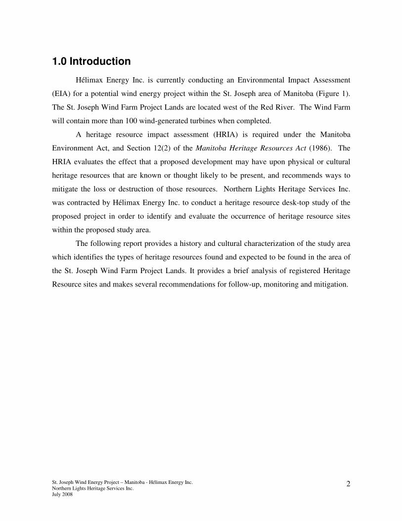
1.0 Introduction
Hélimax Energy Inc. is currently conducting an Environmental Impact Assessment
(EIA) for a potential wind energy project within the St. Joseph area of Manitoba (Figure 1).
The St. Joseph Wind Farm Project Lands are located west of the Red River. The Wind Farm
will contain more than 100 wind-generated turbines when completed.
A heritage resource impact assessment (HRIA) is required under the Manitoba
Environment Act, and Section 12(2) of the Manitoba Heritage Resources Act (1986). The
HRIA evaluates the effect that a proposed development may have upon physical or cultural
heritage resources that are known or thought likely to be present, and recommends ways to
mitigate the loss or destruction of those resources. Northern Lights Heritage Services Inc.
was contracted by Hélimax Energy Inc. to conduct a heritage resource desk-top study of the
proposed project in order to identify and evaluate the occurrence of heritage resource sites
within the proposed study area.
The following report provides a history and cultural characterization of the study area
which identifies the types of heritage resources found and expected to be found in the area of
the St. Joseph Wind Farm Project Lands. It provides a brief analysis of registered Heritage
Resource sites and makes several recommendations for follow-up, monitoring and mitigation.
St. Joseph Wind Energy Project – Manitoba - Hélimax Energy Inc.
Northern Lights Heritage Services Inc.
July 2008
3
Figure 1. Map of the Study Area in South-Central Manitoba.
St. Joseph Wind Energy Project – Manitoba - Hélimax Energy Inc.
Northern Lights Heritage Services Inc.
July 2008
4
2.0 Study Area Characterization
2.1 Environment
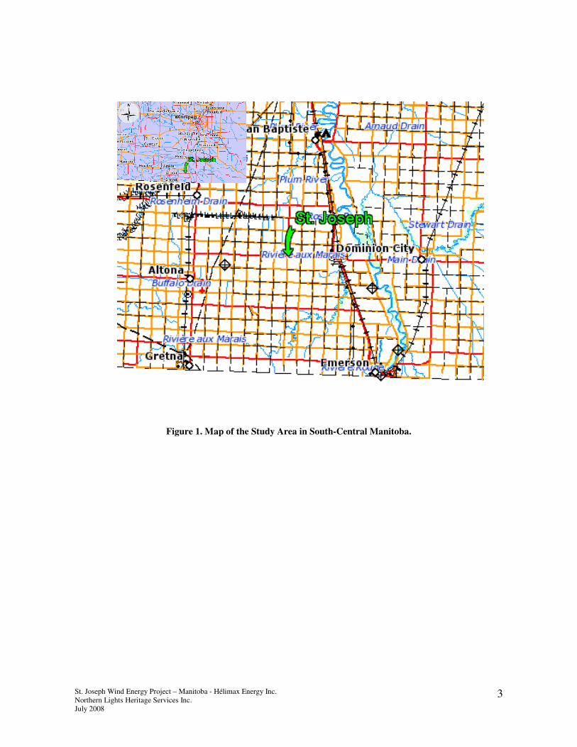
The St. Joseph Wind Farm Project study area is located within the Lake Manitoba
Plains Ecoregion 162, (Figure 2) and is characterized by short, warm summers and long, cold
winters with continuous snow cover. It is typified by low-relief, underlain by limestone
bedrock and covered by smooth, level, poorly drained lacustrine sands, silts, and clays. The
predominant vegetation is a mosaic of trembling aspen/oak groves and rough fescue
grasslands. Environment Canada describes this ecoregion as follows:
Wildlife includes significant waterfowl, as well as white-tailed deer, coyote, rabbit,
and ground squirrel. Its growing season length, available heat, and precipitation
permit the production of corn, spring wheat, and other cereal grains by dryland
continuous cropping methods. Oilseeds, hay, and livestock production are more
prevalent in the northern section owing to topography and stoniness limitations.
Hunting and water-oriented recreation are additional significant uses of land. The
major communities include Winnipeg, Portage la Prairie, Emerson, and Dauphin. The
population of the ecoregion is approximately 782 100. (Government of Canada-
Environment Canada, 2005).
Figure 2. Prairie Ecoregions. Map courtesy of Environment Canada.
St. Joseph

St. Joseph Wind Energy Project – Manitoba - Hélimax Energy Inc.
Northern Lights Heritage Services Inc.
July 2008
5
2.2 Historical Background
The community of St. Joseph is situated northwest of Emerson. St. Joseph was first
known as Mission de la Rivière aux Marais, after the river flowing past Letellier. Archbishop
Taché established a parish here in 1877 and named it St. Joseph, after the patron saint of
Canada. The area was largely settled by French Canadians from Quebec (Manitoba
Conservation 2000). Research indicates that the Francophone settlement originated not from
historic Métis but from expatriate Québécois who had previously fled to New England (Lehr
1996).
Prior to its establishment as a settlement the area was known for its rich buffalo
resources. A number of Aboriginal trails criss-crossed the study area and this network was
later used by European explorers and traders. This area may have first been historically noted
by La Vérendrye during his 1738 expedition to the Mandan Indians in North Dakota. The
explorer, Alexander Henry, is known to have established his major post at nearby Park River
in 1800, sending small detachments to winter at Rivière aux Marais (near St. Joseph) and Hair
Hills. (Manitoba Culture, Heritage and Citizenship 1994: 3).
The Boundary Commission Trail extended west from the Red River at the town of
Emerson (Fort Dufferin) and was originally used by traders and hunters until the 1870s and
1880s when it was adopted as a route for the North West Mounted Police.
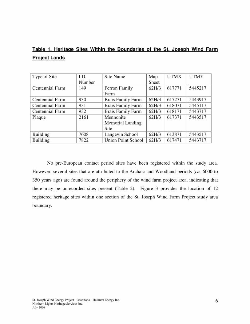
2.3 Cultural Chronology of the St. Joseph Wind Farm Project Study Area
Southern Manitoba is rife with heritage resources dating back as far as 11,500 years
ago. Part of the heritage resource desktop study is to document all known heritage resources
within the study area. For the St. Joseph Wind Farm Project the immediate study area
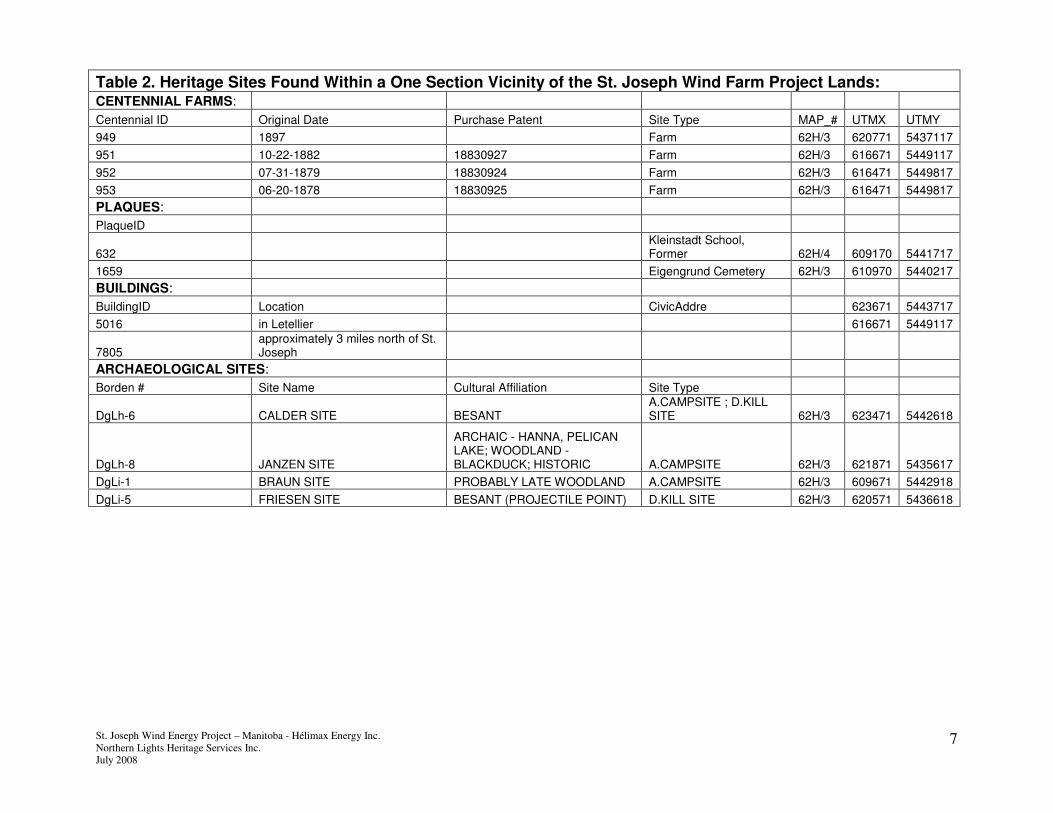
contains seven heritage sites representing the late historic period (Table 1).
St. Joseph Wind Energy Project – Manitoba - Hélimax Energy Inc.
Northern Lights Heritage Services Inc.
July 2008
6
Table 1. Heritage Sites Within the Boundaries of the St. Joseph Wind Farm
Project Lands
No pre-European contact period sites have been registered within the study area.
However, several sites that are attributed to the Archaic and Woodland periods (ca. 6000 to
350 years ago) are found around the periphery of the wind farm project area, indicating that
there may be unrecorded sites present (Table 2). Figure 3 provides the location of 12
registered heritage sites within one section of the St. Joseph Wind Farm Project study area
boundary.
Type of Site I.D.
Number
Site Name Map
Sheet
UTMX UTMY
Centennial Farm 149 Perron Family
Farm
62H/3 617771 5445217
Centennial Farm 930 Brais Family Farm 62H/3 617271 5443917
Centennial Farm 931 Brais Family Farm 62H/3 618071 5445117
Centennial Farm 932 Brais Family Farm 62H/3 618171 5443717
Plaque 2161 Mennonite
Memorial Landing
Site
62H/3 617371 5443517
Building 7608 Langevin School 62H/3 613871 5443517
Building 7822 Union Point School 62H/3 617471 5443717
St. Joseph Wind Energy Project – Manitoba - Hélimax Energy Inc.
Northern Lights Heritage Services Inc.
July 2008
7
Table 2. Heritage Sites Found Within a One Section Vicinity of the St. Joseph Wind Farm Project Lands: CENTENNIAL FARMS:
Centennial ID Original Date Purchase Patent Site Type MAP_# UTMX UTMY
949 1897 Farm 62H/3 620771 5437117
951 10-22-1882 18830927 Farm 62H/3 616671 5449117
952 07-31-1879 18830924 Farm 62H/3 616471 5449817
953 06-20-1878 18830925 Farm 62H/3 616471 5449817
PLAQUES:
PlaqueID
632 Kleinstadt School, Former 62H/4 609170 5441717
1659 Eigengrund Cemetery 62H/3 610970 5440217
BUILDINGS:
BuildingID Location CivicAddre 623671 5443717
5016 in Letellier 616671 5449117
7805 approximately 3 miles north of St. Joseph
ARCHAEOLOGICAL SITES:
Borden # Site Name Cultural Affiliation Site Type
DgLh-6 CALDER SITE BESANT A.CAMPSITE ; D.KILL SITE 62H/3 623471 5442618
DgLh-8 JANZEN SITE
ARCHAIC - HANNA, PELICAN LAKE; WOODLAND - BLACKDUCK; HISTORIC A.CAMPSITE 62H/3 621871 5435617
DgLi-1 BRAUN SITE PROBABLY LATE WOODLAND A.CAMPSITE 62H/3 609671 5442918
DgLi-5 FRIESEN SITE BESANT (PROJECTILE POINT) D.KILL SITE 62H/3 620571 5436618

St. Joseph Wind Energy Project – Manitoba - Hélimax Energy Inc.
Northern Lights Heritage Services Inc.
July 2008
8
Figure 3. Map of the Study Area Indicating the Location of Registered Heritage Resource Sites Within
and Adjacent to the study area. Archaeological Sites Are Identified By Borden Numbers The purple star
represents an unnamed Centennial Farm located just outside the study area on the east side of the N/S
section road.
St. Joseph Wind Energy Project – Manitoba - Hélimax Energy Inc.
Northern Lights Heritage Services Inc.
July 2008
9
3.0 Culture History
The last advancement of the Wisconsinan glacial sheet occurred ca. 23,000 YA
completely burying Manitoba underneath several kilometers of ice. Beginning approximately
16,000 years ago, a global warming trend known as the Holocene gradually melted enough of
the ice sheet to expose the southern portion of the province (Teller, 1984:25). Ponded
meltwater at the base of the retreating glacier formed Glacial Lake Agassiz whose
configuration and drainage changed over a period of about 4,000 years. Covering 350,000
square kilometers at its largest extent, Lake Agassiz did not allow for human habitation east
of the Manitoba escarpment until about 7500 years ago (Teller, 1984:35). Once the glacial
lake had drained plants, animals and humans quickly moved into new areas.
The first peoples of Manitoba entered from the south or west following the retreat of
the Wisconsinan glacial ice and the ponding of glacial Lake Agassiz, between 11,500 and
11,000 years ago. Based on the artifactual remains, archaeologists have subdivided the
ancient past into three cultural periods. These Pre-European contact Periods (Early, Middle
and Late) are based on the different technologies employed by past peoples and land/resource
use patterns. The more recent past, the Contact Period defined by European contact of the
last 350 years, has also been subdivided into three periods, Early, Middle and Late Historic.
The oral histories and legends of the Plains Cree, Ojibwa, and Assiniboine provide valuable
detail concerning the lifeways of these more recent Aboriginal cultures. The Historic Period
is augmented by written records such as fur trade journals, maps, ethnographic studies which
provide important detail regarding the development of the province.
St. Joseph Wind Energy Project – Manitoba - Hélimax Energy Inc.
Northern Lights Heritage Services Inc.
July 2008
10
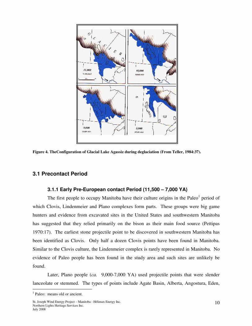
Figure 4. TheConfiguration of Glacial Lake Agassiz during deglaciation (From Teller, 1984:37).
3.1 Precontact Period
3.1.1 Early Pre-European contact Period (11,500 – 7,000 YA)
The first people to occupy Manitoba have their culture origins in the Paleo1 period of
which Clovis, Lindenmeier and Plano complexes form parts. These groups were big game
hunters and evidence from excavated sites in the United States and southwestern Manitoba
has suggested that they relied primarily on the bison as their main food source (Pettipas
1970:17). The earliest stone projectile point to be discovered in southwestern Manitoba has
been identified as Clovis. Only half a dozen Clovis points have been found in Manitoba.
Similar to the Clovis culture, the Lindenmeier complex is rarely represented in Manitoba. No
evidence of Paleo people has been found in the study area and such sites are unlikely be
found.
Later, Plano people (ca. 9,000-7,000 YA) used projectile points that were slender
lanceolate or stemmed. The types of points include Agate Basin, Alberta, Angostura, Eden,
1 Paleo: means old or ancient.

St. Joseph Wind Energy Project – Manitoba - Hélimax Energy Inc.
Northern Lights Heritage Services Inc.
July 2008
11
Hell Gap, Manitoba, Midland, Milnesand, Scottsbluff and Plainview complexes. Little is
known about Plano sites in Manitoba as to date, most artifacts have been surface finds with no
associated cultural markers.
3.1.2 Middle Pre-European contact Period (7,000 -2500 YA)
The first of the cultural complexes of the Middle Pre-European contact Period is
known as the Logan Creek culture (7,000-5,500 YA). This culture has distinctive large side-
notched points and a more diverse diet of plants, animals and shellfish. This change in food
resources is considered to be in part a result of a period of global warming known as the
Altithermal. This period of higher temperatures caused the region to become more arid than
today, turning the entire study area into grasslands that stretched as far north as Grand Rapids,
MB.
Climatic stabilization appears to have been a factor in the movement of several plains
groups into Manitoba. The Oxbow (5,300-3,000 YA) and McKean (5,000-3,000 YA) were
the dominant complexes of this time period. Bison was the preferred dietary staple,
supplemented with various other resources. Oxbow people likely moved into Manitoba from
the west as the earliest Oxbow discoveries are found west of the Manitoba Escarpment.
Although primarily bison hunters, they could have also harvested game adapted to the boreal
forest such as caribou, moose and deer. The McKean Complex points are found throughout
Manitoba - this wide distribution suggests that these people were highly mobile and adapted
easily to the local environment. Similar to the Oxbow people, McKean groups were hunters
and gatherers with bison the preferred resource. They also hunted a wide range of large and
small game as well as fish and collected an assortment of wild plants for food and medicine.
In addition to stone, material such as bone, antler and shell were used to create tools such as
awls, needles, hide scrapers and personal adornments.
An eastern influence arrived in the form of the Old Copper culture (5,000-3,000 YA)
named because of the association with copper tools and nodules. Approximately 50 Old
Copper specimens have been found in the Boreal Forest, Grassland, and Aspen Parkland areas
of Southern Manitoba (Pettipas, 1984:66). All of the copper used in the Old Copper culture
complex was mined in the Lake Superior Basin. The copper nuggets were probably carried
from their source and tools made locally..
St. Joseph Wind Energy Project – Manitoba - Hélimax Energy Inc.
Northern Lights Heritage Services Inc.
July 2008
12
The Pelican Lake culture (3,000– 2,000 Years Ago.) is the final group considered to
have occupied this region during the Middle Period. As with other groups of this period, the
Pelican Lake people were bison hunters who augmented their diet with a wide range of plants
and animals. Pelican Lake campsites were often quite large. Tipi ring sites found in the
north-western plains indicate seasonal occupation by fairly large groups. The seasonal
activities of the Pelican Lake people have been determined to include winter camps in
sheltered valleys with major bison drives in the spring and fall (Reeves 1970:162).
3.1.3 Late Pre-European contact (2, 500 B.P. to 300 YA)
The Late Pre-European contact period is identified by new technologies that were
adapted to or invented by local groups in response to the changing physical environment and
local resources. The lifeways of these people is referred to as the Woodland Tradition
(Pettipas, 1996:72). The Woodland people introduced clay pottery in Manitoba and their
technologies included the bow and arrow. Archaeologists believe that these new technologies
mark the beginning of a changing subsistence economy that made more frequent use of fish
and small mammal resources. Woodland sites contain more fish bone and small mammal
bone than earlier cultural occupations. Because of the change in subsistence, people appear to
have become more sedentary, spending more time at summer locations than they had in the
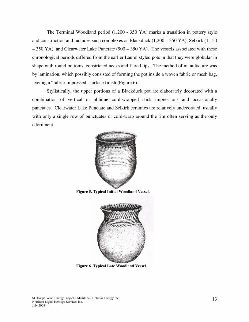
past. The Woodland Tradition is divided into two periods, Initial and Terminal, which are
based primarily on distinctive ceramic manufacturing techniques and decoration.
The Initial Woodland period (2,500 – 1,000 YA) is marked by the presence of coiled,
clay pottery and is generally referred to as Laurel by archaeologists. Rolled coils of clay were
placed on top of each other to form the sides of the vessel. The walls were then pounded with
a paddle to thin the sides and increase the vessels height. Decorative incisions such as
pseudo-scallop, and dentates along with bosses and punctuates were applied in various
combinations to produce numerous designs (Figure 5). Tool technologies include small
triangular projectile points, net-sinkers and hammerstones as well as many bone tools and
harpoon points. During this period Plains pottery also made its way into the southern reaches
of Manitoba. It may be that Besant and Sonota groups (ca. 2000-1200 YA) manufactured
vessels similar to those found further south in North Dakota.
St. Joseph Wind Energy Project – Manitoba - Hélimax Energy Inc.
Northern Lights Heritage Services Inc.
July 2008
13
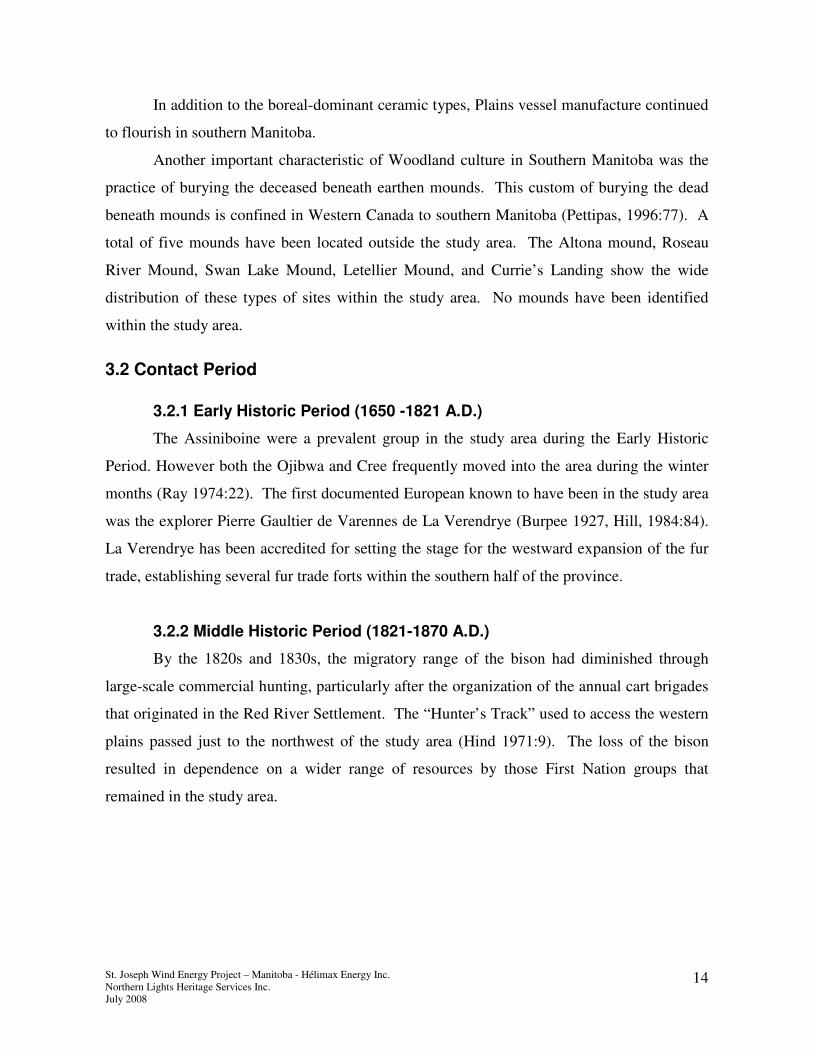
The Terminal Woodland period (1,200 - 350 YA) marks a transition in pottery style
and construction and includes such complexes as Blackduck (1,200 – 350 YA), Selkirk (1,150
– 350 YA), and Clearwater Lake Punctate (900 – 350 YA). The vessels associated with these
chronological periods differed from the earlier Laurel styled pots in that they were globular in
shape with round bottoms, constricted necks and flared lips. The method of manufacture was
by lamination, which possibly consisted of forming the pot inside a woven fabric or mesh bag,
leaving a “fabric-impressed” surface finish (Figure 6).
Stylistically, the upper portions of a Blackduck pot are elaborately decorated with a
combination of vertical or oblique cord-wrapped stick impressions and occasionally
punctates. Clearwater Lake Punctate and Selkirk ceramics are relatively undecorated, usually
with only a single row of punctuates or cord-wrap around the rim often serving as the only
adornment.
Figure 5. Typical Initial Woodland Vessel.
Figure 6. Typical Late Woodland Vessel.
St. Joseph Wind Energy Project – Manitoba - Hélimax Energy Inc.
Northern Lights Heritage Services Inc.
July 2008
14
In addition to the boreal-dominant ceramic types, Plains vessel manufacture continued
to flourish in southern Manitoba.
Another important characteristic of Woodland culture in Southern Manitoba was the
practice of burying the deceased beneath earthen mounds. This custom of burying the dead
beneath mounds is confined in Western Canada to southern Manitoba (Pettipas, 1996:77). A
total of five mounds have been located outside the study area. The Altona mound, Roseau
River Mound, Swan Lake Mound, Letellier Mound, and Currie’s Landing show the wide
distribution of these types of sites within the study area. No mounds have been identified
within the study area.
3.2 Contact Period
3.2.1 Early Historic Period (1650 -1821 A.D.)
The Assiniboine were a prevalent group in the study area during the Early Historic
Period. However both the Ojibwa and Cree frequently moved into the area during the winter
months (Ray 1974:22). The first documented European known to have been in the study area
was the explorer Pierre Gaultier de Varennes de La Verendrye (Burpee 1927, Hill, 1984:84).
La Verendrye has been accredited for setting the stage for the westward expansion of the fur
trade, establishing several fur trade forts within the southern half of the province.
3.2.2 Middle Historic Period (1821-1870 A.D.)
By the 1820s and 1830s, the migratory range of the bison had diminished through
large-scale commercial hunting, particularly after the organization of the annual cart brigades
that originated in the Red River Settlement. The “Hunter’s Track” used to access the western
plains passed just to the northwest of the study area (Hind 1971:9). The loss of the bison
resulted in dependence on a wider range of resources by those First Nation groups that
remained in the study area.
St. Joseph Wind Energy Project – Manitoba - Hélimax Energy Inc.
Northern Lights Heritage Services Inc.
July 2008
15
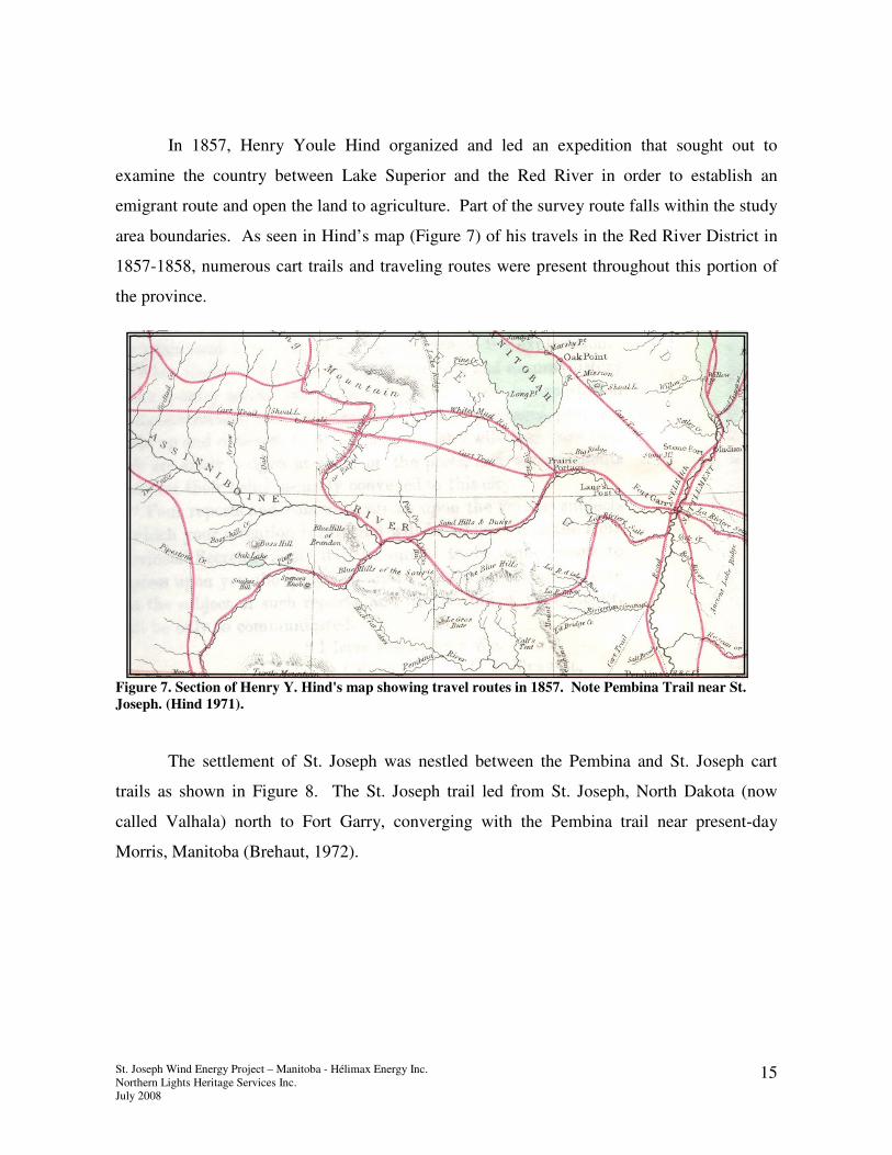
In 1857, Henry Youle Hind organized and led an expedition that sought out to
examine the country between Lake Superior and the Red River in order to establish an
emigrant route and open the land to agriculture. Part of the survey route falls within the study
area boundaries. As seen in Hind’s map (Figure 7) of his travels in the Red River District in
1857-1858, numerous cart trails and traveling routes were present throughout this portion of
the province.
Figure 7. Section of Henry Y. Hind's map showing travel routes in 1857. Note Pembina Trail near St.
Joseph. (Hind 1971).
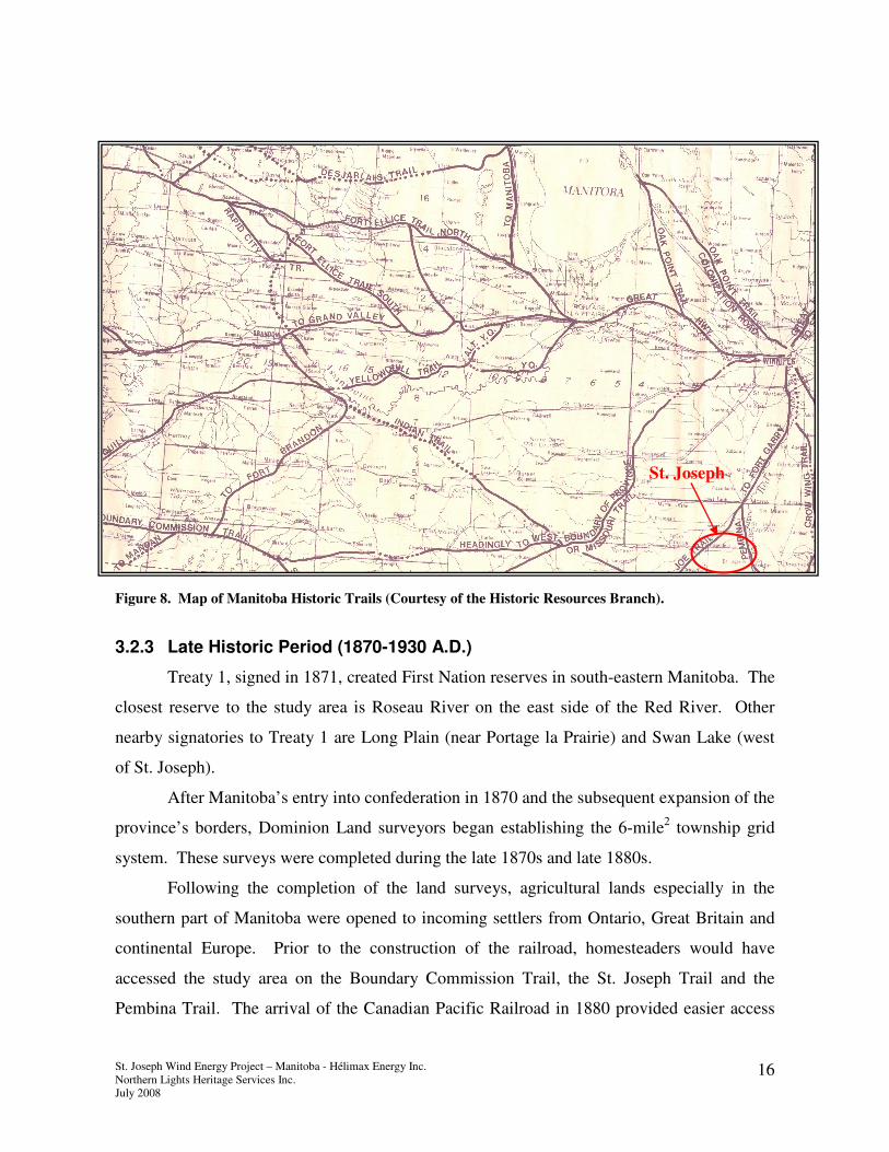
The settlement of St. Joseph was nestled between the Pembina and St. Joseph cart
trails as shown in Figure 8. The St. Joseph trail led from St. Joseph, North Dakota (now
called Valhala) north to Fort Garry, converging with the Pembina trail near present-day
Morris, Manitoba (Brehaut, 1972).
St. Joseph Wind Energy Project – Manitoba - Hélimax Energy Inc.
Northern Lights Heritage Services Inc.
July 2008
16
Figure 8. Map of Manitoba Historic Trails (Courtesy of the Historic Resources Branch).
3.2.3 Late Historic Period (1870-1930 A.D.)
Treaty 1, signed in 1871, created First Nation reserves in south-eastern Manitoba. The
closest reserve to the study area is Roseau River on the east side of the Red River. Other
nearby signatories to Treaty 1 are Long Plain (near Portage la Prairie) and Swan Lake (west
of St. Joseph).
After Manitoba’s entry into confederation in 1870 and the subsequent expansion of the
province’s borders, Dominion Land surveyors began establishing the 6-mile2 township grid
system. These surveys were completed during the late 1870s and late 1880s.
Following the completion of the land surveys, agricultural lands especially in the
southern part of Manitoba were opened to incoming settlers from Ontario, Great Britain and
continental Europe. Prior to the construction of the railroad, homesteaders would have
accessed the study area on the Boundary Commission Trail, the St. Joseph Trail and the
Pembina Trail. The arrival of the Canadian Pacific Railroad in 1880 provided easier access
St. Joseph

St. Joseph Wind Energy Project – Manitoba - Hélimax Energy Inc.
Northern Lights Heritage Services Inc.
July 2008
17
into the area as well as a conduit for agricultural produce to be shipped to Winnipeg as well as
eastern Canada and the United States. Villages and towns were established and, shortly
thereafter, the organization of municipal governments.
4.0 Analysis
The existing heritage resource inventory identified seven historical sites within the
study area. These include four Centennial Farms, one plaque and two buildings. Sites found
a distance of 1 section outside the boundary of the study area included four Centennial Farms,
two plaques, two buildings and four archaeological sites.
Based on the coordinates provided by the Province of Manitoba Archaeological
Inventory for archaeological sites archaeological, site DgLi-5 is located at the southeastern
corner of the study area. This site was identified as a “Kill Site”, possibly where bison were
slaughtered. Projectile points identified as Besant (ca. 2000-1200 YA) were found here. The
site was considered to be in poor condition in 1986 and may be completely destroyed due to
agricultural activities.
Site DgLi-1 (The Braun Site) was identified in 1986 as a Late Woodland site (ca.
1000-350 YA). Site condition was noted to be almost completely destroyed. It is known that
Mr. Todd Braun carried out an extensive collection of projectile points over many years in
this area and there may be many sites that were never registered with the province. Because
of this it is highly likely that additional sites exist within the Wind Farm study area. Further,
burial mounds have been identified east, south and west of the study area. Therefore there it
is possible that burial mounds/burials could be encountered.
One Centennial Farm (CF 949) is located on the east side of the N/S section road.
This site will not be affected by the project, but is noted for future reference.
In addition to the pre-European contact component, the network of historical major
trails and a subset of local trails exist. Added to this, are the numerous homesteads that
represent the first French settlers and the later Mennonite farmers who established the area.
St. Joseph Wind Energy Project – Manitoba - Hélimax Energy Inc.
Northern Lights Heritage Services Inc.
July 2008
18
5.0 Recommendations
An acceptable setback or buffer of 300 m from known heritage sites is recommended
as the minimal distance between the wind turbines and heritage sites. This will minimize any
impacts of known sites. While this is within acceptable limits for construction purposes the
potential for soil disturbance due to access roads, staging areas and storage compounds could
present some risk to undiscovered sites. It must be kept in mind that because the physical
location of most archaeological sites is below ground surface and because minimal
archaeological field survey has occurred in this area it is difficult to determine which area
may contain heritage resources and which may not.. However, given the many years of
agricultural activity throughout this area there is probably less risk of intact sites being
disturbed by the construction of a wind turbine farm.
A recommendation is made that prior to construction of turbine structures within 1-km
from known archaeological and/or cultural heritage sites that archaeological field survey is
considered. This may be requested by the Heritage Resources Branch of the Manitoba
Culture Heritage and Tourism as part of the Heritage Resource Impact Assessment (HRIA)
(archaeological field investigation). Usually, the archaeological investigations for an HRIA
report on the condition of known and existing sites and flag areas of concern. This may or
may not be followed up by monitoring of initial field construction at locations that were
identified as medium to high risk during the field investigation.
Particular caution should be taken at WTG sites close to the settlement of St. Joseph
since several Centennial Farms are located in the vicinity. Here as with other known heritage
sites, a buffer of 300 metres should be in place. A further caution is the potential for both pre-
European contact and historic burials and abandoned cemeteries to be present. Should human
remains be found during any component of the project all work at that location must halt and
the Historic Resources Branch called immediately (Province of Manitoba Policy for the
Exhumation of Found Human Remains 1987).

St. Joseph Wind Energy Project – Manitoba - Hélimax Energy Inc.
Northern Lights Heritage Services Inc.
July 2008
19
6.0 References
Brehaut, Henry Baker
1972 The Red River Cart and Trails: The Fur Trade. MHS Transactions Series 3, Number
28, 1971-72 season.
Burpee, Lawrence J.
1927 Journals and Letters of Pierre Gauthier de Varennes de la Verendrye and His Sons.
The Champlain Society, Toronto, ON.
Government of Canada – Environment Canada
2005 Narrative Descriptions of Terrestrial Ecozones and Ecoregions of Canada.
http://www.ec.gc.ca/soer-ree/English/Framework/Nardesc/borpln_e.cfm
Government of Manitoba
nd Archaeological Site Inventory. The Historic Resources Branch, Manitoba Culture
Heritage and Tourism, Winnipeg, MB.
1986 The Manitoba Heritage Resources Act. Manitoba Culture Heritage and Citizenship.
Winnipeg, MB.
1987 Province of Manitoba Policy for the Exhumation of Found Human Remains.
Manitoba Culture Heritage and Citizenship. Winnipeg, MB
1994 The Fur Trade in the Scratching River Region. Historic Resources Branch. Manitoba
Culture Heritage and Tourism, Winnipeg MB.
2000 . Geographical Names of Manitoba. Manitoba Conservation 2000. P 239
Hill, C. Gordon
1984 Journey Through Time: An introduction to the Archaeology and Culture History of the
MSTW Planning District. Papers in Manitoba Archaeology Popular Series No.6.
Historic Resources Branch, Winnipeg MB.
Hind, Henry Youle.
1971 Narrative of the Canadian Red River Exploring Expedition of 1857 and of the
Assiniboine and Saskatchewan Exploring Expedition of 1858. Charles E. Tuttle Co.
Rutland, Vermont.
Lehr, John C.
1996 Settlement: The Making of a Landscape from The Geography of
Manitoba: Its Land and Its People (Edited by J. Welsted, J. Everitt & C. Stadel).
The University of Manitoba Press. Winnipeg, MB.

St. Joseph Wind Energy Project – Manitoba - Hélimax Energy Inc.
Northern Lights Heritage Services Inc.
July 2008
20
McLeod, K. D.
2000 The Drifting River-Lwiwski (EhMc-18), Ochre Beach (EgLw-5) and Hunter’s Brother
(EhKx-8) Burials. Ms on file, Historic Resources Branch, Manitoba Culture, Heritage
and Tourism, Winnipeg MB.
Northern Lights Heritage Services Inc.
2005 Manitoba Hydro Fibre Optic Installation Project: Southern Manitoba Loop: La
Verendrye – Letellier segment. Ms on file Northern Lights Heritage Services Inc.
Pettipas, L.
1970 Early Man in Manitoba. In Ten Thousand Years: Archaeology in Manitoba. D.W.
Friesen and Sons, Altona, MB.
1984 Introducing Manitoba Prehistory. Papers in Manitoba Archaeology Popular Series
No. 4. Manitoba Culture, Heritage and Recreation, Historic Resources Branch,
Winnipeg, MB.
1996 Aboriginal Migrations: A History of Movements in Southern Manitoba. Manitoba
Museum of Man and Nature, Winnipeg, Manitoba.
Stewart, David A.
1930 Early Assiniboine Trading Posts of the Souris-Mouth Group 1785-1832, The
Historical and Scientific Society of Manitoba, Transaction No. 5, July 1930.
Ray, Arthur J.
1974 Indians in the Fur Trade: Their Role as Trappers, Hunters and Middlemen in the
Lands Southwest of Hudson Bay, 1660-1870. University of Toronto Press, Toronto,
ON.
Reeves, B.
1970 Cultural Dynamics in the Manitoba Grasslands 1000 B.C. – A.D. 700. In Ten
Thousand Years: Archaeology in Manitoba. D.W. Friesen and Sons, Altona, MB.
Teller, James T.
1984 The Ice Age And Its Legacy. In Natural Heritage of Manitoba: Legacy of the Ice Age.
James T. Teller, Editor. Manitoba Museum of Man and Nature, Winnipeg, Manitoba.
Warkentin, J. and I. Ruggles
1970 Historical Atlas of Manitoba. The Historical and Scientific Society of Manitoba
Society, Winnipeg, MB.