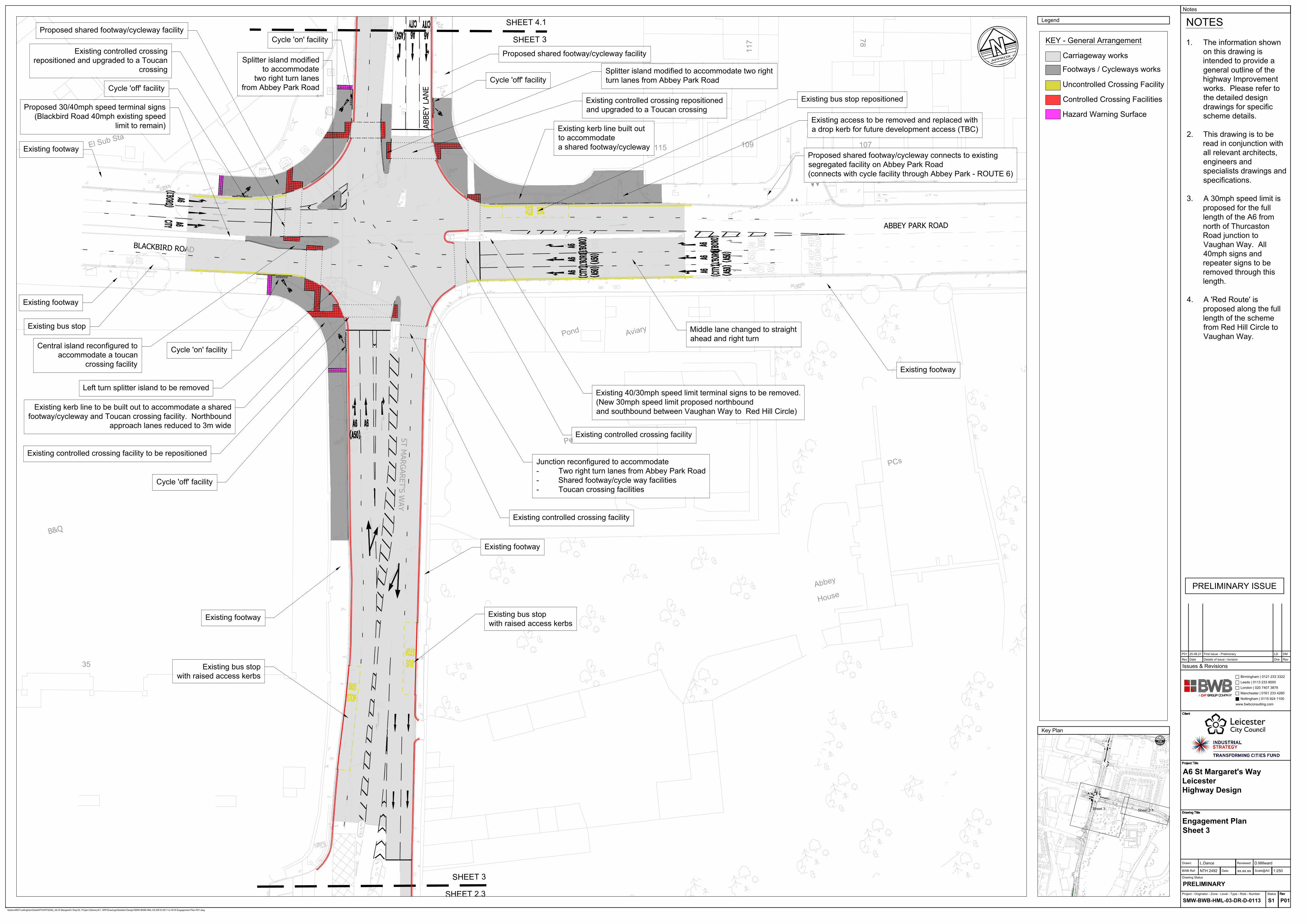
35 El Sub Sta Pond Aviary 107 115 Abbey House PCs 78 117 109 Pets Corner El Sub Sta B&Q ST MARGARET'S WAY ABBEY LANE BLACKBIRD ROAD ABBEY PARK ROAD SHEET 3 SHEET 2.3 SHEET 3 SHEET 4.1 Existing bus stop with raised access kerbs Existing bus stop with raised access kerbs Cycle 'off' facility Existing kerb line to be built out to accommodate a shared footway/cycleway and Toucan crossing facility. Northbound approach lanes reduced to 3m wide Central island reconfigured to accommodate a toucan crossing facility Cycle 'on' facility Left turn splitter island to be removed Cycle 'off' facility Proposed shared footway/cycleway facility Existing controlled crossing repositioned and upgraded to a Toucan crossing Splitter island modified to accommodate two right turn lanes from Abbey Park Road Existing controlled crossing facility to be repositioned Splitter island modified to accommodate two right turn lanes from Abbey Park Road Existing controlled crossing repositioned and upgraded to a Toucan crossing Junction reconfigured to accommodate - Two right turn lanes from Abbey Park Road - Shared footway/cycle way facilities - Toucan crossing facilities Existing kerb line built out to accommodate a shared footway/cycleway Existing bus stop repositioned Existing access to be removed and replaced with a drop kerb for future development access (TBC) Proposed shared footway/cycleway connects to existing segregated facility on Abbey Park Road (connects with cycle facility through Abbey Park - ROUTE 6) Middle lane changed to straight ahead and right turn Proposed shared footway/cycleway facility Cycle 'off' facility Existing footway Existing footway Existing footway Existing controlled crossing facility Existing controlled crossing facility Existing footway Existing footway Existing bus stop Cycle 'on' facility Existing 40/30mph speed limit terminal signs to be removed. (New 30mph speed limit proposed northbound and southbound between Vaughan Way to Red Hill Circle) Proposed 30/40mph speed terminal signs (Blackbird Road 40mph existing speed limit to remain) Sheet 3 Sheet 3.1 Carriageway works Footways / Cycleways works KEY - General Arrangement Uncontrolled Crossing Facility Controlled Crossing Facilities Hazard Warning Surface P01 25.08.21 First Issue - Preliminary DM LD Notes \\bwbnotfil01\nottingham\Data\NTH\NTH2492_A6 St Margaret's Way\02. Project Delivery\01. WIP\Drawings\Detailed Design\SMW-BWB-HML-XX-DR-D-0011 to 0018 Engagement Plan-P01.dwg Issues & Revisions Rev Date Details of issue / revision Rev Drw Birmingham | 0121 233 3322 Leeds | 0113 233 8000 Manchester | 0161 233 4260 London | 020 7407 3879 Nottingham | 0115 924 1100 www.bwbconsulting.com BWB Ref: Date: Scale@A0: Drawn: Reviewed: Drawing Status Project - Originator - Zone - Level - Type - Role - Number Status Drawing Title Project Title Client Rev Drawing Title Project Title Client Rev Drawing Title Project Title Client Rev Drawing Title Project Title Client Rev Drawing Title Project Title Client Rev S1 SMW-BWB-HML-03-DR-D-0113 PRELIMINARY L.Dance D.Millward NTH 2492 Engagement Plan Sheet 3 A6 St Margaret's Way Leicester Highway Design 1:250 xx.xx.xx P01 APPROX Key Plan APPROX Legend PRELIMINARY ISSUE NOTES 1. The information shown on this drawing is intended to provide a general outline of the highway Improvement works. Please refer to the detailed design drawings for specific scheme details. 2. This drawing is to be read in conjunction with all relevant architects, engineers and specialists drawings and specifications. 3. A 30mph speed limit is proposed for the full length of the A6 from north of Thurcaston Road junction to Vaughan Way. All 40mph signs and repeater signs to be removed through this length. 4. A 'Red Route' is proposed along the full length of the scheme from Red Hill Circle to Vaughan Way.
Existing kerb line to be built out to accommodate a sharedfootway/cycleway and Toucan crossing facility. Northbound
approach lanes reduced to 3m wide
Central island reconfigured toaccommodate a toucan
crossing facility
Cycle 'on' facility
Left turn splitter island to be removed
Cycle 'off' facility
Proposed shared footway/cycleway facility
Existing controlled crossingrepositioned and upgraded to a Toucan
crossingSplitter island modified
to accommodatetwo right turn lanes
from Abbey Park Road
Existing controlled crossing facility to be repositioned
Splitter island modified to accommodate two rightturn lanes from Abbey Park Road
Existing controlled crossing repositionedand upgraded to a Toucan crossing
Junction reconfigured to accommodate- Two right turn lanes from Abbey Park Road- Shared footway/cycle way facilities- Toucan crossing facilities
Existing kerb line built outto accommodatea shared footway/cycleway
Existing bus stop repositioned
Existing access to be removed and replaced witha drop kerb for future development access (TBC)
Proposed shared footway/cycleway connects to existingsegregated facility on Abbey Park Road(connects with cycle facility through Abbey Park - ROUTE 6)
Middle lane changed to straightahead and right turn
Proposed shared footway/cycleway facility
Cycle 'off' facility
Existing footway
Existing footway
Existing footway
Existing controlled crossing facility
Existing controlled crossing facility
Existing footway
Existing footway
Existing bus stop
Cycle 'on' facility
Existing 40/30mph speed limit terminal signs to be removed.(New 30mph speed limit proposed northboundand southbound between Vaughan Way to Red Hill Circle)
\\bwbnotfil01\nottingham\Data\NTH\NTH2492_A6 St Margaret's Way\02. Project Delivery\01. WIP\Drawings\Detailed Design\SMW-BWB-HML-XX-DR-D-0011 to 0018 Engagement Plan-P01.dwg
Issues & RevisionsRev Date Details of issue / revision RevDrw
Birmingham | 0121 233 3322Leeds | 0113 233 8000
Manchester | 0161 233 4260London | 020 7407 3879
Nottingham | 0115 924 1100www.bwbconsulting.com
BWB Ref: Date: Scale@A0:
Drawn: Reviewed:
Drawing Status
Project - Originator - Zone - Level - Type - Role - Number Status
Drawing Title
Project Title
Client
Rev
Drawing Title
Project Title
Client
Rev
Drawing Title
Project Title
Client
Rev
Drawing Title
Project Title
Client
Rev
Drawing Title
Project Title
Client
Rev
S1SMW-BWB-HML-03-DR-D-0113
PRELIMINARY
L.Dance D.Millward
NTH 2492
Engagement PlanSheet 3
A6 St Margaret's WayLeicesterHighway Design
1:250xx.xx.xx
P01
APPROX
Key Plan
APPROX
Legend
PRELIMINARY ISSUE
NOTES
1. The information shownon this drawing isintended to provide ageneral outline of thehighway Improvementworks. Please refer tothe detailed designdrawings for specificscheme details.
2. This drawing is to beread in conjunction withall relevant architects,engineers andspecialists drawings andspecifications.
3. A 30mph speed limit isproposed for the fulllength of the A6 fromnorth of ThurcastonRoad junction toVaughan Way. All40mph signs andrepeater signs to beremoved through thislength.
4. A 'Red Route' isproposed along the fulllength of the schemefrom Red Hill Circle toVaughan Way.