Embed Size (px)
Citation preview

OIL CONS. DIV D\ST. 3District 11625 N. French Dr., Hobbs, NM 88240 District II811 S. First St., Artesia, NM 88210 District 1111000 Rio Brazos Road, Aztec, NM 87410 District IV1220 S. St. Francis Dr., Santa Fe, NM 87505
State of New MexicoEnergy Minerals and Natural Resources
JAN 2 9 Form C-141Revised August 8,2011
Oil Conservation Division 1220 South St. Francis Dr.
Santa Fe, NM 87505
Submit 1 Copy to appropriate District Office in accordance with 19.15.29 NMAC.
Release Notification and Corrective ActionOPERATOR Initial Report □ Final Report
Name of Company ConocoPhillips Company Contact Lisa HunterAddress 5525 Hwy 64, Farmington, NM 87401 Telephone No. 505-326-9525Facility Name MangumNo. 1 Facility Type Natural Gas Well
Surface Owner BLM Mineral Owner Federal (SF-047020-B) API No. 30-045-07835
LOCATION OF RE1LEASEUnit Letter Section Township Range Feet from the North/South Line Feet from the East/West Line County
L 27 29N 11W 2200 South 1175 West San Juan
Latitude 36.69571° Longitude 107.98404°
NATURE OF RELEASEType of Release Historic Release of Produced Water and/or Condensate Volume of Release Unknown Volume Recovered 0Source of Release Believed to be from former AGT Date and Hour of Occurrence Date and Hour of Discovery 04/06/15Was Immediate Notice Given?
13 Yes □ No □ Not RequiredIf YES, To Whom?NMOCD
By Whom? Ashley Maxwell-COP Date and Hour April 17, 2015 12:46PMWas a Watercourse Reached?
13 Yes □ NoIf YES, Volume Impacting the Watercourse. Unknown
If a Watercourse was Impacted, Describe Fully.* A groundwater sample was collected through the soil boring augers and analyzed by EPA Method802IB. Ethylbenzene was detected at a concentration of 160 parts per billion (ppb). Xylenes were detected at a concentration of 930 ppb.
Describe Cause of Problem and Remedial Action Taken.* On April 6, 2015, seven backhoe test holes were dug to depths of 7.5 to 8 ft deep on the site as part of a due diligence site assessment. Soil samples were collected from the test holes and field screened using a PID and field TPH test kit. Samples from two test holes that indicated TPH field screening concentrations above the 100 parts per million (ppm) site action level were thus submitted for laboratory analysis by EPA Method 8015D. One of these samples indicated a concentration of 3,180 ppm TPH. The location of this boring appears to coincide with the location of a former AGT belonging to a fomier site operator and a release from this tank is the apparent source of contamination. On April 17, 2015 a soil boring was drilled with hollow stem auger to determine the vertical extent of impacts in the area of the impacted test hole location and where the former AGT was located. Two soil samples from the auger boring were analyzed by EPA Method 8015. The 10-11.5 ft below ground surface (bgs) sample had a concentration of 425 ppm and the 15-16.5 ft bgs sample had a concentration of 1,530 ppm. Groundwater was encountered at a depth of 16.5 ft bgs.A groundwater sample was collected through the augers and analyzed by EPA Method 802IB. This sample had a concentration of 160 ppb ethylbenzene and 930 ppb xylenes. Test hole locations impacted with TPH concentrations above site action levels were backfilled with clean soils and impacted soils were hauled to a Iandfarm. Impacted soils from the auger boring were also included with soils that were removed to the landfarm.Describe Area Affected and Cleanup Action Taken.* The size of the affected area is unknown. COP will conduct a soil excavation beginning at the current known area of soil and groundwater impacts, below the former AGT. Field screening with PID and Petroflag field screening kit will be used to guide the excavation. Once regulatory closure is reached, the excavation will be backfilled and compacted with BLM-approved material. A groundwater monitoring well will then be installed downgradient from the excavation to assess impacts.I hereby certify that the information given above is true and complete to the best of my knowledge and understand that pursuant to NMOCD rules and regulations all operators are required to report and/or file certain release notifications and perform corrective actions for releases which may endanger public health or the environment. The acceptance of a C-141 report by the NMOCD marked as "Final Report" does not relieve the operator of liability should their operations have failed to adequately investigate and remediate contamination that pose a threat to ground water, surface water, human health or the environment. In addition, NMOCD acceptance of a C-141 report does not relieve the operator of responsibility for compliance with any other federal, state, or local laws and/or regulations. /
Signature: v
OIL CONSERVATION DIVISION / -<zT~7
Printed Name: Lisa Hunter
Title: Field Environmental Specialist Approval Date: rKJ / / / (p Expiration Date:
E-mail Address: [email protected] Conditions of Approval: Attached □
Date: January- 28, 20016 Phone: 505-258-1607* Attach Additional Sheets If Necessary

State of New MexicoEnergy, Minerals and Natural Resources Department
Susana MartinezGovernor
David MartinCabinet Secretary
Brett F. Woods, Ph.D.Deputy Cabinet Secretary
David R. Catanach, Division DirectorOil Conservation Division
New Mexico Oil Conservation Division approval and conditions listed below are made in accordance with OCD Rule 19.15.7.11
Application Type:□ P&A □ Drilling/Casing Change □ Location Change
I ReCOmplete/DHC (For hydraulic fracturing operations review EPA
Underground injection control Guidance #84)
X] Other: Remediation Plan
API WELL # WellName
Well#
Operator Name Type Slat County Surf_Owner UL Sec Tup N/S W/E
30-045-07835-00-00
MANGUM 001 BURLINGTON RESOURCES OIL & GAS COMPANY LP
G ' SanJuan
F 1 " 29 N II W
Conditions of Approval:
OCD has reviewed ConocoPhillips (COPC) remediation plan submitted Janruary 29, 2016. OCD approves COPC remediation plan to excavate and haul the contaminate mass to a Division Approved facility with the following conditions of approval.
• COPC will provide Notification to the OCD 72 hours but not more than one week prior to the start of excavation and installation of monitor well(s).
• COPC will provide Notification to the OCD atleast 24 but no more than one week prior to the collection of any conformation samples.
• COPC will sample the base and sidewalls for TPH, BTEX, and Chlorides by collecting at a minimum a 5 pt composit sample of each side wall and the base.
• COPC will return to the site within 60 Days after completion of the excavation to collect a water sample using EPA Method 8260
OCD is concerned that the prevous collected water sample could have been cross contaminated and would recommed that COPC construct a properly constructed and developed temporoary monitor well to collect the required sample. If CQPC encounters ground water the base soil sample will not be required.
NMOCD Appfeved by Signature Date1220 South St. Francis Drive ■ Santa Fe, New Mexico 87505
Phone (505) 476-3460 • Fax (505) 476-3462 • www.emnrd.state.nm.us/ocd
3ILC0NS. DIVD1ST. 3
JAN 2 9 2016
January 18, 2016 Reference No. 11102646
Cory Smith, Environmental Specialist Oil Conservation Division Energy, Minerals & Natural Resources 1000 Rio Brazos Aztec, NM 87410
Dear Mr. Smith:
Re: Remediation PlanMangum No.1 S27, T29N, R11W San Juan County, New Mexico
On behalf of ConocoPhillips Company (ConocoPhillips), GHD Services (GHD) is pleased to present this workplan to remediate hydrocarbons in soil at the above referenced site (the Site). This workplan is being submitted to address soil impacts from an historic release consisting of approximately 200 barrels (bbls) of produced water and condensate at the Site.
An initial release assessment was conducted in April 2015 for the ConocoPhillipsSan Juan Business Unit (SJBU) by Animas Environmental Services, LLC (AES). In the May 4, 2015AES Mangum # 1 Release Assessment Report, the Site was assigned soil and water remediationaction levels in accordance with New Mexico Oil Conservation Division (NMOCD) release protocols asfollows:
• Depth to Groundwater: Groundwater was encountered at 16.5 feet below ground surface (ft bgs) during soil boring activities at the Mangum #1. (20 points)
• Wellhead Protection Area: Water well SJ 02664 is located approximately 900 feet to the east.
(20 points)
• Distance to Surface Water Body: An irrigation canal (Hammond Ditch) is approximately 150 feet west and north of the location. There is also an unnamed stream approximately 350 feet to the north that discharges directly to the San Juan River. (20 points)
Based on this, the site-specific Recommended Remediation Action Levels (RRALs) are10 parts per million (ppm) benzene, 50 ppm BTEX (benzene, toluene, ethylbenzene, xylenes), and100 ppm total petroleum hydrocarbons (TPH)
GHD Services Inc.6121 Indian School Road NE Suite 200 Albuquerque New Mexico 87110 USA T 505 884 0672 F 505 884 4932 W www.ghd.com
1. Project Information
The Site is located on federal land within Section 27, Township 29N, Range 11W,San Juan County, New Mexico. Geographical coordinates for the Site are 36.69571° North, 107.98404° West. The location and Site layout details are presented as Figures 1 and 2, respectively.
In April 2015 AES excavated seven assessment trenches at the Site using a backhoe (Figure 3). The trenches were dug to depths of from 7.5 to 8 ft bgs and soils were reported to consist primarily of cobbles. No actual assessment trench logs were included in the report. Soils observed in the TH-4 and TH-5 assessment trenches above the 7.5 to 8 ft bgs elevation were described to have encountered an apparent fill material that may have derived from an historical excavation, however, this activity could not be verified. One soil boring was also drilled to a depth of 16.5 ft bgs in the approximate area determined by historical Site diagrams and aerial imagery to have been a former tank location.
Samples were collected from the bottom of each assessment trench (7.5 or 8 ft bgs) and at 11.5 and 16 ft bgs in the soil boring. Soil samples collected during this initial Site assessment were field screened for total volatile organic vapors (VOCs) with a photoionization detector (PID) and for TPH with a field test kit.
Confirmation laboratory samples were submitted from assessment trench (test holes) TH-4 and TH-5, located within the footprint of the aforementioned historical tank location. The laboratory analytical result from the TH-5 sample, collected from a depth of 8 ft bgs, indicated a TPH concentration of 2700 mg/kg (ppm).
A groundwater sample was collected through the augers from the soil boring as it penetrated a water table at 16.5 ft bgs. The sample was analyzed for BTEX constituents and the result indicated xylenes at a concentration of 930 micrograms per liter (parts per billion), above the New Mexico Water Control Commission Standard of 630 ppb.
The AES Site assessment trench TH-5 encountered impacted soils in the location associated with a former on-Site tank. The assessment trench TH-4, located approximately 15 ft to the northwest of TH-5 encountered soil concentrations below laboratory detection limits. Assessment trenches TH-1 through TH-3 excavated to the northeast of the release location had field sampling results below action levels, as did TH-6 and TH-7, excavated west of the release location.
GHD proposes to excavate impacted soils beginning in the source area and the extent of excavation will be guided using field screening techniques and through laboratory confirmation sampling.
2. Scope of Work
The scope of work for this project will involve the excavation of impacted soil to approximately 16 to 20 ft bgs, in the area of the TH-5 assessment trench. For the purposes of this workplan, a volume of 1,500 cubic yards (cy) of soil is used for cost estimating. This would cover an excavation of approximately 40 ft X 50 ft in area, up to 20 ft bgs (Figure 3). The following outlines basic project details that will be completed by GHD and its subcontractors:
GHD | 2016 Remediation Plan -11102646 (1) 2
Fieldwork will begin with a project kickoff meeting. The project kickoff meeting will include a discussion of the Health and Safety Plan (HASP), applicable Job Hazard Analyses, and stop work authority. GHD oversight of excavation activities will be conducted by an OSHA Excavation Competent Person. Tailgate safety meetings will be conducted daily at the beginning of the day and as conditions change. The field program will consist of the following:
• The anticipated impacted area, as indicated in Figure 3, will be excavated to a depth of approximately 16 to 20 ft bgs. Impacted soil will be disposed of at Industrial Ecosystems landfarm facility.
• Soils will be field screened during excavation using a calibrated PID and Petroflag kit for hydrocarbon assessment and a Hach chloride test kit. Field screening will be used to guide the excavation. Confirmation samples will be collected from the sidewalls of each excavation and analyzed for TPH (Gasoline Range Organics/Diesel Range Organics) by EPA Method 8015, Benzene Toluene Ethylbenzene and Xylenes (BTEX) by EPA Method 8260 and chlorides by EPA Method 300.0.
• Field screened soils that indicate TPH concentrations below the 100 ppm will be segregated to the extent possible and possibly used as eventual backfill material.
• The excavation will be backfilled to grade using clean fill material, once regulatory levels are achieved, either from segregated Site soils, or imported material. The backfill material shall be wheel roll compacted, using on-site equipment.
• After completion of backfill activities, the disturbed areas will be restored to their pre-excavation condition as accepted by ConocoPhillips and the Bureau of Land Management (BLM).
The excavation will continue until field screening data indicate soil sample are below RRALs. GHD will obtain approval from ConocoPhillips and the BLM prior to continuing excavation and soil disposal activities beyond the original estimate of 1,500 cy.
Upon completion of remediation, a letter report summarizing activities to date will be submitted. The letter report will include a Site description, project history, description of field events, a discussion of results, and recommendations. The report will include:
• A scaled site plan showing the locations of the excavation and other site features (including latitude and longitude coordinates).
• Tabulation of field screening and laboratory analytical test results.
• Copies of waste manifests.
• Final, geo-referenced site photographs.
Report recommendations will include a plan for the number and location of monitoring wells to be installed at the site to assess groundwater quality. These activities will be performed in a subsequent work phase.
Health and Safety Considerations
GHD | 2016 Remediation Plan - 11102646 (1) 3

Personal protective equipment including fire retardant clothing, steel-toed work boots, gloves, safety glasses and hard hats will be required (basic Level D requirements) during field tasks. The project HASP will be maintained onsite. It will be reviewed and signed by on-site personnel, subcontractors, and authorized visitors.
Quality Assurance/Quality Control
Soil excavation and sampling will be completed in accordance with GHDs standardQuality Assurance/Quality Control procedures designed to minimize cross-contamination betweensamples and to provide reliable laboratory results.
Schedule
GHD is prepared to initiate the scope of work immediately, subsequent to ConocoPhillips and NMOCD approvals, the availability of resources and stakeholder concurrence. A start date and schedule of report submittals will be provided following receipt of subcontractor availability.
If you have any questions or comments with regards to this work plan, please do not hesitate to contact GHDs Albuquerque office at (505) 884-0672. Your timely response to this correspondence is appreciated.
GHD
Jeffrey Walker, CPG, PMP Bernie Bockisch, PMPProject Manager Sr. Project Manager
JW/mc/1
Enel. (3)
• Figure 1 - Site Location Map
• Figure 2 - Site Details Map
• Figure 3 - Site Assessment Trench and Boring Locations/Proposed Area of Excavation
GHD | 2016 Remediation Plan -11102646 (1) 4
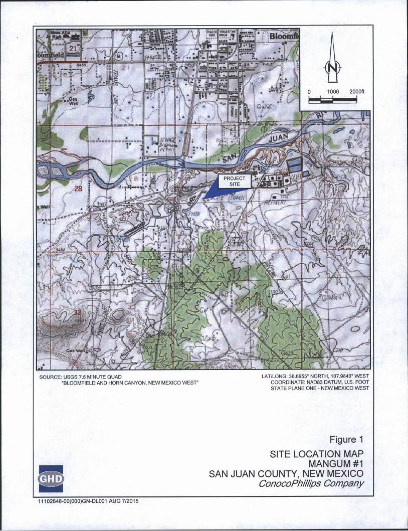
SOURCE: USGS 7.5 MINUTE QUAD LAT/LONG: 36.6955° NORTH, 107.9840° WEST"BLOOMFIELD AND HORN CANYON, NEW MEXICO WEST' COORDINATE: NAD83 DATUM, U.S. FOOT
STATE PLANE ONE - NEW MEXICO WEST
Figure 1
SITE LOCATION MAP MANGUM #1
SAN JUAN COUNTY, NEW MEXICO ConocoPhillips Company
11102646-00(000)GN-DL001 AUG 7/2015
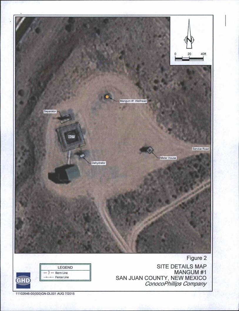
Figure 2
LEGEND— ) — Berm Line
—*—■— Fence Line
SITE DETAILS MAP MANGUM #1
SAN JUAN COUNTY, NEW MEXICO ConocoPhillips Company
11102646-00(000)GN-DL001 AUG 7/2015

[Mangum #1 Wellhead
Separator
Service Road
Meter HouseDehydrator
"* TH-4 $,
Proposed Area of Excavation
SB-1/GW-1
[Approximate Former Tank Location
Proposed Area of Excavation
Assessment Trench
Soil Boring Location
Berm Line
Fence Line
Figure 3
SITE ASSESSMENT TRENCH AND BORING LOCATIONS/PROPOSED AREA OF EXCAVATION
MANGUM #1 SAN JUAN COUNTY, NEW MEXICO
ConocoPhillips Company
11102646-00(000)GN-DL001 AUG 7/2015
May 4, 2015 OIL CONS. DIVDIST. 3
Lisa Hunter ConocoPhillips
San Juan Business Unit Office 214-04
5525 Hwy 64Farmington, New Mexico 87401
Via electronic mail to:SJBUE-Team(a)ConocoPhilliDS.com
RE: Release Assessment ReportMangum #1San Juan County, New Mexico
Dear Ms. Hunter:
On April 6 and 17, 2015, Animas Environmental Services, LLC (AES) completed a release assessment at the ConocoPhillips (CoP) Mangum #1, located in San Juan County, New Mexico. The historic release consisted of approximately 200 barrels (bbls) of produced water and condensate.
JAN 2 9 2016
1.0 Site Information
1.1 Location
Site Name - Mangum #1Location - NWA SW%, Section 27, T29N, R11W, San Juan County, New Mexico Well Head Latitude/Longitude - N36.69571 and W107.98404, respectively Release Location Latitude/Longitude - N36.69540 and W107.98396, respectively Land Jurisdiction - Bureau of Land Management (BLM)Figure 1. Topographic Site Location MapFigure 2. Aerial Site Map, April 20 15 604 w. Pinon St.
Farmington, NM 87401
505-564-2281
1911 Main, Ste 280
Durango, CO
970-403-3084
www.animasenvironmental.com
1.2 NMOCD Ranking
In accordance with New Mexico Oil Conservation Division (NMOCD) release protocols, action levels were established per NMOCD Guidelines for Remediation of Leaks, Spills, and Releases (August 1993) prior to site work. The release was given a ranking score of 60 based on the following factors:
■ Depth to Groundwater: Groundwater was encountered at 16.5 feet below ground surface (bgs) during soil boring activities at the Mangum #1. (20 points)
■ Wellhead Protection Area: Water well SJ 02664 is located approximately 900 feet to the east. (20 points)
■ Distance to Surface Water Body: An irrigation canal (Hammond Ditch) is approximately 150 feet west and north of the location. There is also an unnamed stream approximately 350 feet to the north that discharges directly to the San Juan River. (20 points)
1.3 Assessment
AES was initially contacted by Lindsay Dumas of CoP and on April 6, 2015, Ross Kennemer and Emilee Skyles of AES began the release assessment field work. The assessment included collection and field sampling of seven soil samples from seven test holes in and around the release area. Test holes were terminated between 7.5 to 8 feet bgs and consisted primarily of cobbles. All petroleum contaminated soil was removed from the location for proper disposal at an offsite facility. Clean, native fill soil was used to fill in TH-4 and TH-5. Sample locations and results are presented on Figure 3.
On April 17, 2015, AES returned to the location with a CME-75 hollow stem auger drill rig in order to determine the vertical extent of contamination. One soil boring was placed within the contaminated area that was determined during the initial assessment (TH-5). The assessment included collection and field sampling of two soil samples. Samples were not collected between the surface and 8 feet due to clean imported backfill material. Groundwater was encountered at 16.52 feet bgs. The soil boring location and results are presented on Figure 4.
Lisa HunterMangum #1 Release Assessment Report
May 4, 2015Page 2
2.0 Soil Sampling
Seven soil samples from seven test holes (TH-1 through TH-7) and two samples from one soil boring (SB-1 at 11 ft and SB-1 at 16 ft) were collected during the assessments. All soil samples were field screened for volatile organic compounds (VOCs) and analyzed for total petroleum hydrocarbons (TPH). Two samples (TH-4 at 7.5 ft and TH-5 at 8 ft) were also submitted for confirmation laboratory analysis.

2.1 Field Sampling
Lisa HunterMangum #1 Release Assessment Report
May 4, 2015Page 3
2.1.1 Volatile Organic CompoundsField screening for VOC vapors was conducted with a photo-ionization detector (PID) organic vapor meter (OVM). Before beginning field screening, the PID-OVM was first calibrated with 100 parts per million (ppm) isobutylene gas.
2.1.2 Total Petroleum HydrocarbonsField TPH samples were analyzed per U.S. Environmental Protection Agency (USEPA) Method 418.1 using a Buck Scientific Model HC-404 Total Hydrocarbon Analyzer Infrared Spectrometer (Buck). A 3-point calibration was completed prior to conducting soil analyses. Field analytical protocol followed AES's Standard Operating Procedure: Field Analysis Total Petroleum Hydrocarbons per EPA Method 418.1.
2.2 Laboratory Analyses
The soil samples collected for laboratory analysis were placed into new, clean, laboratory- supplied containers, which were then labeled, placed on ice, and logged onto a sample chain of custody record. Samples were maintained on ice until delivery to the analytical laboratory, Hall Environmental Analysis Laboratory (Hall) in Albuquerque, New Mexico. All soil samples were laboratory analyzed for:
■ Benzene, toluene, ethylbenzene, and xylene (BTEX) per USEPA Method 8021B.■ TPH for gasoline range organics (GRO), diesel range organics (DRO), and motor oil
range organics (MRO) per USEPA Method 8015D.
2.3 Field and Laboratory Analytical Results
On April 6 and 17, 2015, release assessment field screening results for VOCs via OVM showed concentrations ranging from 0.0 ppm in TH-1 and TH-2 up to 2,662 ppm in TH-5. Field TPH concentrations ranged from less than 20.0 mg/kg in TH-3 up to greater than 2,500 mg/kg in TH-5. Results are included below in Table 1 and on Figure 3. The AES Field Sampling Reports are attached.

Lisa HunterMangum U1 Release Assessment Report
May 4, 2015Page 4
Table 1. Field Sampling VOCs and TPH Results Mangum #1 Release Assessment, April 2015
Sample VOCs TPHDate Depth via OVM 418.1
Sample ID Sampled (ftbgs) (ppm) (mg/kg)NMOCD Action Level* 100 100
TH-1 4/06/15 7.5 0.0 23.0
TH-2 4/06/15 7.5 0.0 25.4
TH-3 4/06/15 8 1.3 <20.0
TH-4 4/06/15 7.5 265 36.2
TH-5 4/06/15 8 2,662 >2,500
TH-6 4/06/15 7.5 2.2 30.2
TH-7 4/06/15 8 0.7 27.8
SB-111.5 1,824 425
16 3,676 1,530
*Action level determined by the NMOCD ranking score per NMOCD Guidelines for Remediation of Leaks, Spills, and Releases (August 1993)
Laboratory analyses for TH-4 and TH-5 were used to confirm field sampling results of the initial release assessment. Benzene concentrations were reported below laboratory detection limits in each sample. Total BTEX concentrations were reported as less than 0.245 mg/kg and at 33 mg/kg in TH-4 and TH-5, respectively. TPH concentrations as GRO/DRO/MRO were reported at less than 63.6 mg/kg in TH-4 and 2,700 mg/kg in TH-5. Results are presented in Table 2 and on Figure 3. The laboratory analytical report is attached.
Table 2. Laboratory Analytical Results - Benzene, Total BTEX, and TPH ___________ Mangum #1 Release Assessment, April 2015___________
Sample IDDate
Sampled
Sample Depth (ft bgs)
Benzene(mg/kg)
TotalBTEX
(mg/kg)GRO
(mg/kg)DRO
(mg/kg)MRO
(mg/kg)NMOCD Action Level* 10 50 100
TH-4 4/06/15 7.5 <0.049 <0.245 <4.9 <9.7 <49
TH-5 4/06/15 8 <0.25 33 1,600 1,100 <480*Action level determined by the NMOCD ranking score per NMOCD Guidelines for Remediation of Leaks, Spills, and Releases (August 1993)

3.0 Groundwater Sampling
On April 17, 2015, AES used a new disposable bailer inserted into the hollow stem of the drill rig assembly to collect one grab sample (GW-1) from the accumulated recharged groundwater. An interface probe was used to determine the depth to water. Sample GW-1 was submitted to Hall for laboratory analyses of the following:
■ BTEX per USEPA Method 8021B.
3.1 Laboratory Analytical Results
Laboratory analytical results for the water sample (GW-1) reported dissolved phase concentrations of less than 5.0 pg/L benzene, less than 10 pg/L toluene, 160 pg/L ethylbenzene, and 930 pg/L xylenes. Laboratory analytical results are included in Table 3 and on Figure 3.
Lisa HunterMangum #1 Release Assessment Report
May 4, 2015Page 5
Table 3. Groundwater Laboratory Analytical Results - Benzene, Toluene, Ethylbenzene, and Xylenes Mangum #1 Release Assessment, April 2015
Sample IDDate
SampledBenzene(pg/t)
Toluene(pg/L)
Ethyl - Benzene(pg/L)
Xylenes(pg/L)
WQCC Standards 10 750 750 620
GW-1 04/17/15 <5.0 <10 160 930
4.0 Conclusions and Recommendations
On April 6, 2015, AES conducted a release assessment of petroleum contaminated soils associated with a historic release of produced water and condensate at the Mangum #1. Action levels for releases are determined by the NMOCD ranking score per NMOCD Guidelines for Remediation of Leaks, Spills, and Releases (August 1993), and the site was assigned a rank of 60.
Release assessment field sampling results above the NMOCD action level of 100 ppm VOCs and 100 mg/kg TPH were reported in TH-4 and TH-5. The highest VOC and TPH concentrations were reported in TH-5 with 2,662 ppm and greater than 2,500 mg/kg, respectively. Laboratory analyses for TH-4 and TH-5 were used to confirm field sampling results. Benzene and total BTEX concentrations were reported below the NMOCD action levels of 10 mg/kg and 50 mg/kg, respectively, in both samples. TPH concentrations as

GRO/DRO/MRO in TH-4 were below the NMOCD action level of 100 mg/kg; however, TPH concentrations in TH-5 were above the NMOCD action level with 2,700 mg/kg.
On April 17, 2015, a grab groundwater sample (GW-1) was collected from the immediate vicinity of the release location. Laboratory analytical results showed dissolved phase benzene, toluene and ethylbenzene below the applicable New Mexico WQCC standards; however, dissolved phase xylenes concentrations exceeded the WQCC standard of 620 pg/L with 930 pg/L. Depth to groundwater was measured at 16.52 feet bgs.
Based on final field sampling and laboratory analytical results of the release assessment at the Mangum #1, continued horizontal delineation of hydrocarbon impacted soils and groundwater is recommended.
If you have any questions about this report or site conditions, please do not hesitate to contact me at (505) 564-2281.
Sincerely,
St
Emilee Skyles Geologist
Lisa HunterMangum #1 Release Assessment Report
May 4, 2015Page 6
Elizabeth McNally, PE
Attachments:Figure 1. Topographic Site Location Map Figure 2. Aerial Site Map, April 2015Figure 3. Initial Assessment Sample Locations and Results, April 2015Figure 4. Soil Boring Sample Location and Results, April 2015AES Field Sampling Report 040615AES Field Sampling Report 041715Hall Laboratory Analytical Report 1504214Hall Laboratory Analytical Report 1504799
R:\Animas 2000\Dropbox (Animas Environmental)\0000 Animas Server Dropbox EM\2015
Projects\ConocoPhillips\Mangum l\Mangum #1 Release Assessment Report 050415.docx

;k*t> ,
Mm
IANGUM #1
arfSnr
w:-'
2,000 1,000 2,000
(1 INCH = 2,000 FEET)
FIGURE 1
TOPOGRAPHIC SITE LOCATION MAPConocoPhillips
MANGUM #1
NWH swVa, SECTION 27, T29W, R11W SAN JUAN COUNTY, NEW MEXICO
N36.69571, W107.98404Animas Environmental Serv ices, llc
DRAWN BY:
S. Glasses
DATE DRAWN:April 7, 2015
REVISIONS BY:
C. Lameman
DATE REVISED:April 7, 2015
CHECKED BY:E. Skyles
DATE CHECKED:April 7, 2015
APPROVED BY:E. McNally
DATE APPROVED:April 7, 2015

SEPARATOR]
METERIhouseIidehydratorI
[AERIAL SOURCE: © 2014 PICTOMETRY INTERNATIONAL CORP. ONLINE, AERIAL DATE; MARCH 12, 2011]
LEGEND
SECONDARY CONTAINMENT BERM
— x— FENCE
ANGUM #1 WELLHEAD
BGT
SERVICE ROAD
SCALE
(1 INCH = 40 FEET)
Animas Environmental Services. LLC
DRAWN BY:
S. Glasses
DATE DRAWN:April 7, 2015
REVISIONS BY:
C. Lameman
DATE REVISED:April 7, 2015
CHECKED BY:E. Skyles
DATE CHECKED:April 7, 2015
APPROVED BY:E. McNally
DATE APPROVED:April 7, 2015
FIGURE 2AERIAL SITE MAP
APRIL 2015ConocoPhillips
MANGUM #1
NW% SWK, SECTION 27, T29W, R11W
SAN JUAN COUNTY, NEW MEXICO
N36.69571, W107.98404

Field Sampling Results
Sample ID DateDepth
(ft)
OVM-PID
(ppm)
TPH(mg/kg)
NMOCD ACTION LEVEL 100 100TH-1 4/6/15 7.5 0.0 23.0
TH-2 4/6/15 7.5 0.0 25.4
TH-3 4/6/15 8 1.3 <20.0
TH-4 4/6/15 7.5 265 36.2
TH-5 4/6/15 8 2,662 >2,500TH-6 4/6/15 7.5 2.2 30.2
TH-7 4/6/15 8 0.7 27.8
Laboratory Analytical Results
Sample ID DateDepth
(ft)Benzene(mg/kg)
TotalBTEX
(mg/kg)
TPH - GRO
(mg/kg)
TPH - DRO
(mg/kg)
TPH - MRO
(mg/kg)
NMOCD ACTION LEVEL 10 50 100TH-4 4/6/15 7.5 <0.049 <0.245 <4.9 <9.7 <49
TH-5 4/6/15 8 <0.25 33 1,600 1,100 <480ALL SAMPLES WERE ANALYZED PER USEPA METHOD 8021B AND 8015D.
MANGUM#! WELLHEAD
TH-1
ASSESSMENT TRENCHES
TH-2
TH-3
SERVICE ROAD
METERHOUSE
APPROXIMATE RELEASE LOCATION
APPROXIMATE FORMER TANK LOCATION DETERMINED THROUGH 1964 MERIDIAN OIL SITE DIAGRAM AND 2005 GOOGLE EARTH HISTORIC IMAGERY.
INITIAL ASSESSMENT SAMPLE LOCATIONS AND RESULTS
APRIL 2015ConocoPhillips
MANGUM #1
NWy4 SW%, SECTION 27, T29W, R11W SAN JUAN COUNTY, NEW MEXICO
N36.69571, W107.98404
Animas Environmentdl Services, LLC
DRAWN BY:
S. Glasses
REVISIONS BY:
C. Lameman
CHECKED BY:E. Skyles
APPROVED BY:E. McNally
DATE DRAWN:April 15, 2015
DATE REVISED:April 15, 2015
DATE CHECKED:April 15, 2015
DATE APPROVED:April 15, 2015
LEGEND
SECONDARY CONTAINMENT BERM
— x— FENCE
SCALE
SERVICE ROAD

Soil Field Sampling Results
Sample ID DateDepth
(ft)
OVM-PID
(ppm)
TPH(mg/kg)
NMOCD ACTION LEVEL 100 100
SB-1 A/17/1510-11.5 1,824 42515 -16.5 3,676 1,530
Groundwater Laboratory Analytical Results
Sample ID DateBenzene(pg/L)
Toluene(pg/L)
Ethyl-Benzene(pg/L)
Xylenes(pg/L)
WQCC STANDARD 10 750 750 620GW-1 | 4/17/15 <5.0 <10 160 930
NOTE: SAMPLE WAS ANALYZED PER USEPA METHOD 8021B.
MANGUM#! WELLHEAD
HISTORIC IMAGERY.
N'\, SERVICE ROAD
SERVICE ROAD
SOIL BORING SAMPLE LOCATION AND RESULTS
APRIL 2015ConocoPhillips
MANGUM #1
NWyA SWya, SECTION 27, T29W, R11W SAN JUAN COUNTY, NEW MEXICO
N36.69571, W107.98404
Animas Environmental Services, llc
DRAWN BY:
C. Lameman
REVISIONS BY:
C. Lameman
CHECKED BY:E. Skyles
APPROVED BY:E. McNally
DATE DRAWN:April 30, 2015
DATE REVISED:April 30, 2015
DATE CHECKED:April 30, 2015
DATE APPROVED:April 30, 2015
LEGEND
9 SOIL BORING LOCATION
: = = = SECONDARY CONTAINMENT BERM
— X— FENCE
SCALE
20
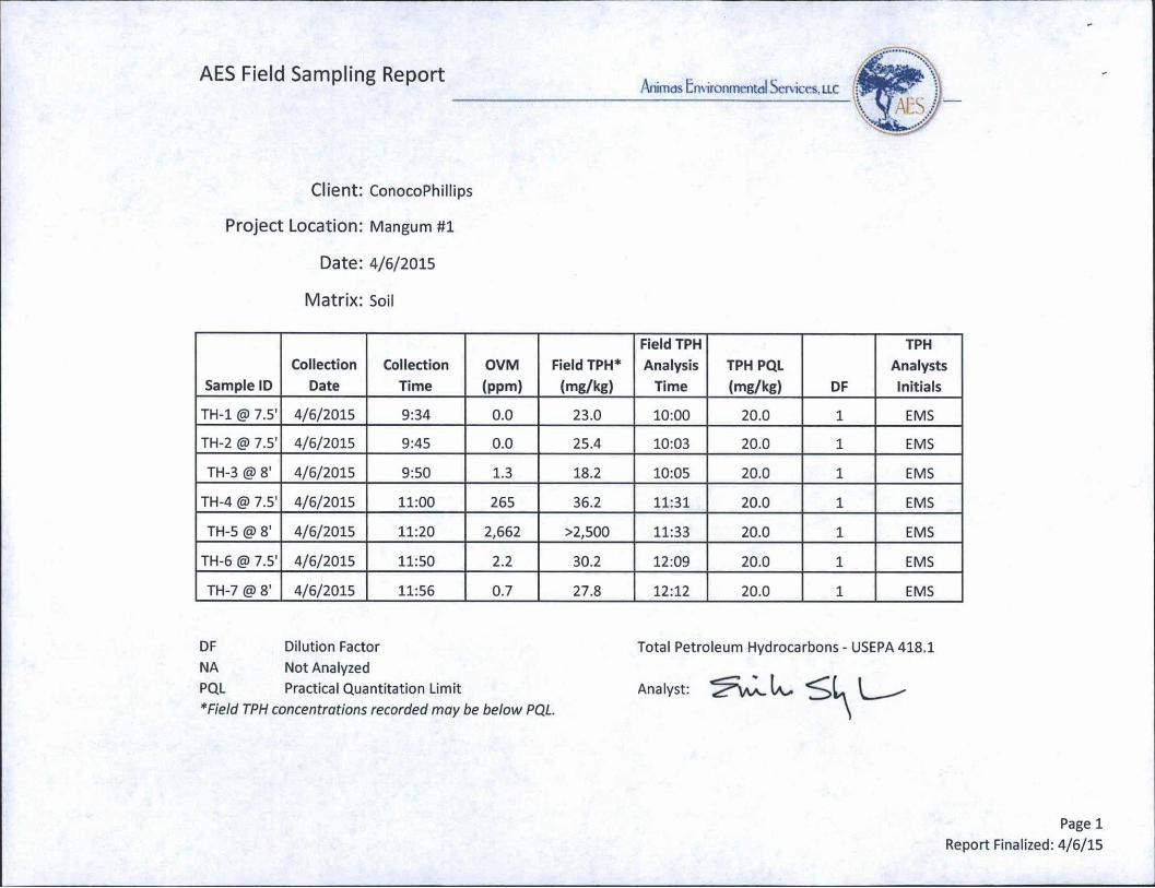
AES Field Sampling ReportAnimas Environmental Services, llc
Client: ConocoPhillips
Project Location: Mangum #1
Date: 4/6/2015
Matrix: Soil
Sample IDCollection
DateCollection
TimeOVM(ppm)
Field TPH* (mg/kg)
Field TPHAnalysis
TimeTPH PQL (mg/kg) DF
TPHAnalystsInitials
TH-1 @ 7.5' 4/6/2015 9:34 0.0 23.0 10:00 20.0 1 EMS
TH-2 @ 7.5' 4/6/2015 9:45 0.0 25.4 10:03 20.0 1 EMS
TH-3 @ 8' 4/6/2015 9:50 1.3 18.2 10:05 20.0 1 EMS
TH-4 @ 7.5' 4/6/2015 11:00 265 36.2 11:31 20.0 1 EMS
TH-5 @ 8' 4/6/2015 11:20 2,662 >2,500 11:33 20.0 1 EMS
TH-6 @ 7.5' 4/6/2015 11:50 2.2 30.2 12:09 20.0 1 EMS
TH-7 @ 8' 4/6/2015 11:56 0.7 27.8 12:12 20.0 1 EMS
DF Dilution FactorNA Not AnalyzedPQL Practical Quantitation Limit* Field TPH concentrations recorded may be below PQL
Total Petroleum Hydrocarbons - USEPA 418.1
Page 1Report Finalized: 4/6/15

AES Field Sampling ReportAnirnds Environmental Services. LLC
Client: ConocoPhillips
Project Location: Mangum #1
Date: 4/17/2015
Matrix: Soil
Sample IDCollection
DateCollection
TimeOVM(ppm)
Field TPH* (mg/kg)
Field TPH Analysis
TimeTPH PQL (mg/kg) DF
TPHAnalystsInitials
SB-1 <S> 11.5* 4/17/2015 10:05 1,824 425 10:27 20.0 1 EMS
SB-1 @ 16' 4/17/2015 10:43 3,676 1,530 11:10 20.0 1 EMS
DF Dilution FactorNA Not AnalyzedPQL Practical Quantitation Limit*Field TPH concentrations recorded may be below PQL.
Total Petroleum Hydrocarbons - USEPA 418.1
Page 1Report Finalized: 4/17/15

HALLENVIRONMENTALANALYSIS
Hall Environmental Analysis Laboratory
TEL: 505-345-3975 FAX: 505-345-4107Website: www.hallenvironmental.com
4901 Hawkins NE Albuquerque, NM 87109
■LABORATORY
April 13,2015
Emilee Skyles
Animas Environmental 604 Pinon Street Farmington, NM 87401 TEL: (505) 564-2281
FAX
RE: CoP Mangum #1 OrderNo.: 1504214
Dear Emilee Skyles:
Hall Environmental Analysis Laboratory received 2 sample(s) on 4/7/2015 for the analyses presented in the following report.
These were analyzed according to EPA procedures or equivalent. To access our accredited tests please go to www.hallenviromnental .com or the state specific web sites. In order to properly interpret your results it is imperative that you review this report in its entirety.See the sample checklist and/or the Chain of Custody for information regarding the sample receipt temperature and preservation. Data qualifiers or a narrative will be provided if the sample analysis or analytical quality control parameters require a flag.When necessary, data qualifers are provided on both the sample analysis report and the QC summary report, both sections should be reviewed. All samples are reported, as received, unless otherwise indicated. Lab measurement of analytes considered field parameters that require analysis within 15 minutes of sampling such as pH and residual chlorine are qualified as being analyzed outside of the recommended holding time.
Please don't hesitate to contact HEAL for any additional information or clarifications.
ADHS Cert #AZ0682 - NMED-DWB Cert #NM9425 - NMED-Micro Cert #NM0190
Sincerely,
Andy Freeman
Laboratory Manager
4901 Hawkins NE Albuquerque, NM 87109

Analytical Report
Lab Order 1504214
Hall Environmental Analysis Laboratory, Inc. Date Reported: 4/13/2015
CLIENT: Animas Environmental
Project: CoP Mangum #1
Lab ID: 1504214-001 Matrix: SOIL
Client Sample ID: TH-4 @ 7.5'
Collection Date: 4/6/2015 11:00:00 AM
Received Date: 4/7/2015 6:40:00 AM
Analyses Result RL Qual Units DF Date Analyzed Batch
EPA METHOD 8015D: DIESEL RANGE ORGANICS
Diesel Range Organics (DRO) ND 9.7 mg/Kg 1
Analyst: BCN
4/9/2015 10:51:18 PM 18546Motor Oil Range Organics (MRO) ND 49 mg/Kg 1 4/9/2015 10:51:18 PM 18546
Surr: DNOP 95.2 63.5-128 %REC 1 4/9/2015 10:51:18 PM 18546
EPA METHOD 8015D: GASOLINE RANGE
Gasoline Range Organics (GRO) ND 4.9 mg/Kg 1
Analyst: NSB
4/8/2015 5:02:45 PM 18551Surr: BFB 86.1 80-120 %REC 1 4/8/2015 5:02:45 PM 18551
EPA METHOD 8021B: VOLATILES
Benzene ND 0.049 mg/Kg 1
Analyst: NSB
4/8/2015 5:02:45 PM 18551Toluene ND 0.049 mg/Kg 1 4/8/2015 5:02:45 PM 18551Ethylbenzene ND 0.049 mg/Kg 1 4/8/2015 5:02:45 PM 18551Xylenes, Total ND 0.098 mg/Kg 1 4/8/2015 5:02:45 PM 18551
Surr: 4-Bromofluorobenzene 94.3 80-120 %REC 1 4/8/2015 5:02:45 PM 18551
Refer to the QC Summary report and sample login checklist for flagged QC data and preservation information.
Qualifiers: * Value exceeds Maximum Contaminant Level.E Value above quantitation rangeJ Analyte detected below quantitation limits O RSD is greater than RSDlimit R RPD outside accepted recovery limits S Spike Recovery' outside accepted recovery limits
BH
NDP
RL
Analyte detected in the associated Method BlankHolding times for preparation or analysis exceededNot Detected at the Reporting Limit Page 1 of 5Sample pH Not In RangeReporting Detection Limit

Analytical Report
Lab Order 1504214
Date Reported: 4/13/2015Hall Environmental Analysis Laboratory, Inc.
CLIENT: Animas Environmental Client Sample ID: TH-5 @ 8'
Project: CoPMangum#! Collection Date: 4/6/2015 11:20:00 AM
Lab ID: 1504214-002 Matrix: SOIL Received Date: 4/7/2015 6:40:00 AM
Analyses Result RL Qual Units DF Date Analyzed Batch
EPA METHOD 8015D: DIESEL RANGE ORGANICS Analyst: JME
Diesel Range Organics (DRO) 1100 96 mg/Kg 10 4/10/2015 9:55:09 AM 18546Motor Oil Range Organics (MRO) ND 480 mg/Kg 10 4/10/2015 9:55:09 AM 18546
Surr: DNOP 0 63.5-128 S %REC 10 4/10/2015 9:55:09 AM 18546
EPA METHOD 8015D: GASOLINE RANGE Analyst: NSB
Gasoline Range Organics (GRO) 1600 50 mg/Kg 10 4/8/2015 5:31:27 PM 18551Surr: BFB 1100 80-120 s %REC 10 4/8/2015 5:31:27 PM 18551
EPA METHOD 8021B: VOLATILES Analyst: NSB
Benzene ND 0.25 mg/Kg 10 4/8/2015 5:31:27 PM 18551Toluene ND 0.50 mg/Kg 10 4/8/2015 5:31:27 PM 18551
Ethylbenzene ND 0.50 mg/Kg 10 4/8/2015 5:31:27 PM 18551
Xylenes, Total 33 0.99 mg/Kg 10 4/8/2015 5:31:27 PM 18551Surr: 4-Bromofluorobenzene 194 80-120 s %REC 10 4/8/2015 5:31:27 PM 18551
Refer to the QC Summary report and sample login checklist for flagged QC data and preservation information.
Qualifiers: * Value exceeds Maximum Contaminant Level.E Value above quantitation rangeJ Analyte detected below quantitation limits O RSD is greater than RSDlimit
R RPD outside accepted recovery limits S Spike Recovery outside accepted recovery limits
BH
NDP
RL
Analyte detected in the associated Method Blank Holding times for preparation or analysis exceeded Not Detected at the Reporting Limit Sample pH Not In Range Reporting Detection Limit
Page 2 of 5
*QC SUMMARY REPORTHall Environmental Analysis Laboratory, Inc
WO#: 150421413-Apr-15
Client:
Project:
Animas Environmental
CoP Mangum #1
Sample ID MB-18546 SampType: MBLK TestCode: EPA Method 8015D: Diesel Range Organics
Client ID: PBS Batch ID: 18546 RunNo: 25386
Prep Date: 4/7/2015 Analysis Date: 4/9/2015 SeqNo: 752140 Units: mg/Kg
Analyte Result PQL SPK value SPKRefVal %REC LowLimit HighLimit %RPD RPDLimit QualDiesel Range Organics (DRO) ND 10Motor Oil Range Organics (MRO) ND 50
Sum DNOP 10 10.00 100 63.5 128
Sample ID LCS-18546 SampType: LCS TestCode: EPA Method 8015D: Diesel Range Organics
Client ID: LCSS Batch ID: 18546 RunNo: 25386
Prep Date: 4/7/2015 Analysis Date: 4/9/2015 SeqNo: 752142 Units: mg/Kg
Analyte Result PQL SPK value SPK Ref Val %REC LowLimit HighLimit %RPD RPDLimit QualDiesel Range Organics (DRO) 66 10 50.00 0 132 67.8 130 S
Sum DNOP 6.6 5.000 131 63.5 128 S
Sample ID MB-18616 SampType: MBLK TestCode: EPA Method 8015D: Diesel Range Organics
Client ID: PBS Batch ID: 18616 RunNo: 25410
Prep Date: 4/10/2015 Analysis Date: 4/10/2015 SeqNo: 753570 Units: %REC
Analyte Result PQL SPK value SPK Ref Val %REC LowLimit HighLimit %RPD RPDLimit QualSum DNOP 9.5 10.00 94.7 63.5 128
Sample ID LCS-18616 SampType: LCS TestCode: EPA Method 8015D: Diesel Range Organics
Client ID: LCSS Batch ID: 18616 RunNo: 25410
Prep Date: 4/10/2015 Analysis Date: 4/10/2015 SeqNo: 753573 Units: %REC
Analyte Result PQL SPK value SPKRefVal %REC LowLimit HighLimit %RPD RPDLimit QualSuit DNOP 4.5 5.000 89.3 63.5 128
Qualifiers:* Value exceeds Maximum Contaminant Level. BE Value above quantitation range HJ Analyte detected below quantitation limits NDO RSD is greater than RSDIimit PRS
RPD outside accepted recovery limitsSpike Recovery outside accepted recovery limits
RL
Analyte detected in the associated Method Blank
Holding times for preparation or analysis exceeded
Not Detected at the Reporting Limit Page 3 of 5Sample pH Not In RangeReporting Detection Limit
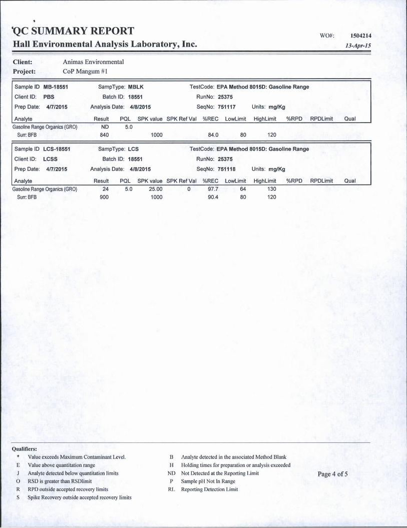
QC SUMMARY REPORTHall Environmental Analysis Laboratory, Inc
WO#: 1504214
13-Apr-15
Client:
Project:
Animas Environmental
CoP Mangum #1
Sample ID MB-18551 SampType: MBLK TestCode: EPA Method 8015D: Gasoline Range
Client ID: PBS Batch ID: 18551 RunNo: 25375
Prep Date: 4/7/2015 Analysis Date: 4/8/2015 SeqNo: 751117 Units: mg/Kg
Analyte Result PQL SPK value SPKRefVal %REC LowLimit HighLimit %RPD RPDLimit Qual
Gasoline Range Organics (GRO) ND 5.0SurrBFB 840 1000 84.0 80 120
Sample ID LCS-18551 SampType: LCS TestCode: EPA Method 8015D: Gasoline Range
Client ID: LCSS Batch ID: 18551 RunNo: 25375
Prep Date: 4/7/2015 Analysis Date: 4/8/2015 SeqNo: 751118 Units: mg/Kg
Analyte Result PQL SPK value SPKRefVal %REC LowLimit HighLimit %RPD RPDLimit QualGasoline Range Organics (GRO)
Sum BFB24 5.0 25.00
900 10000 97.7 64 130
90.4 80 120
Qualifiers:
* Value exceeds Maximum Contaminant Level. BE Value above quantitation range HJ Analyte detected below quantitation limits NDO RSD is greater than RSDiimit PRS
RPD outside accepted recovery limitsSpike Recovery outside accepted recovery limits
RL
Analyte detected in the associated Method BlankHolding times for preparation or analysis exceeded
Not Detected at the Reporting Limit Page 4 of 5Sample pH Not In RangeReporting Detection Limit

WO#:•QC SUMMARY REPORT
Hall Environmental Analysis Laboratory, Inc.1504214
li-Apr-15
Client: Animas Environmental
Project: CoP Mangum #1
Sample ID MB-18551 SampType: MBLK TestCode: EPA Method 8021B: Volatiles
Client ID: PBS Batch ID: 18551 RunNo: 25375
Prep Date: 4/7/2015 Analysis Date: 4/8/2015 SeqNo: 750899 Units: mg/Kg
Analyte Result PQL SPK value SPKRefVal %REC LowLimit HighLimit %RPD RPDLimit Qual
Benzene ND 0.050Toluene ND 0.050Ethylbenzene ND 0.050Xylenes, Total ND 0.10
Surr: 4-Bromofluorobenzene 0.95 1.000 94.8 80 120
Sample ID LCS-18551 SampType: LCS TestCode: EPA Method 8021B: Volatiles
Client ID: LCSS Batch ID: 18551 RunNo: 25375
Prep Date: 4/7/2015 Analysis Date: 4/8/2015 SeqNo. 750900 Units: mg/Kg
Analyte Result PQL SPK value SPKRefVal %REC LowLimit HighLimit %RPD RPDLimit Qual
Benzene 1.2 0.050 1.000 0 119 76.6 128
Toluene 1.1 0.050 1.000 0 115 75 124
Ethylbenzene 1.2 0.050 1.000 0 117 79.5 126
Xylenes, Total 3.5 0.10 3.000 0 117 78.8 124
Surr: 4-Bromofluorobenzene 1.0 1.000 102 80 120
Qualifiers:
* Value exceeds Maximum Contaminant Level. B Analyte detected in the associated Method Blank
E Value above quantitation range H Holding times for preparation or analysis exceeded
J Analyte detected below quantitation limits ND Not Detected at the Reporting Limit
O RSD is greater than RSDlimit P Sample pH Not In Range
R RPD outside accepted recovery limits RL Reporting Detection Limit
S Spike Recovery outside accepted recovery limits
Page 5 of 5

Si HALLENVIRONMENTALANALYSISLABORATORY
Hall Environmental Analysis Laboratory 4901 Hawkins NE
Albuquerque, NM87109 TEL: 505-345-3975 FAX: 505-345-4107
Website: www.hallenvironmental.com
Sample Log-In Check List
1 . Custody seals Intact on sample bottles? Yes □ No □ Not Present 0
2. Is Chain of Custody complete? Yes 0 No □ Not Present Q
3. How was the sample delivered? Courier
Login4. Was an attempt made to cool the samples? Yes 0 No □ NA □
5. Were all samples received at a temperature of >0° C to 6.0°C Yes 0 No □ NA □
6. Sample(s) in proper containers)? Yes 0 No □
7. Sufficient sample volume for Indicated test(s)? Yes 0 No □
8. Are samples (except VOA and ONG) properly preserved? Yes 0 No □
9. Was preservative added to bottles? Yes □ No 0 NA □
10.VOA vials have zero headspace? Yes □ No □ No VOA Vials 0
11. Were any sample containers received broken?Yes □ No 0
# of preservedbottles checked
12. Does paperwork match bottle labels? Yes 0 No □ for pH:
(Note discrepancies on chain of custody) (<2 or >12 unless noted)
13. Are matrices correctly identified on Chain of Custody? Yes 0 No □ Adjusted?
14. Is it clear what analyses were requested? Yes 0 No □
15. Were all holding times able to be met? Yes 0 No □ Checked by:
(If no, notify customer for authorization.)
Special Handling (If applicable)16. Was client notified of all discrepancies with this order? Yes □ No □ NA 0
By Whom:
Regarding:
Client Instructions:
I-----------“ Date ["
Via: □ eMail □ Phone □ Fax □ In Person
.... ............ ... ....... ___, .._ .... ---- ------
17. Additional remarks:
Cooler No; Temp°C | Condition Seal Intact | Seal No Seal Date | Signed By
1 1.0 jGood Yes
Page 1 of 1

HALLENVIRONMENTALANALYSIS
Hall Environmental Analysis Laboratory
TEL: 505-345-3975 FAX: 505-345-4107Website: inni , hallenvironmental. com
4901 Hawkins NE AIbuquerque, NM 87109
■LABORATORY
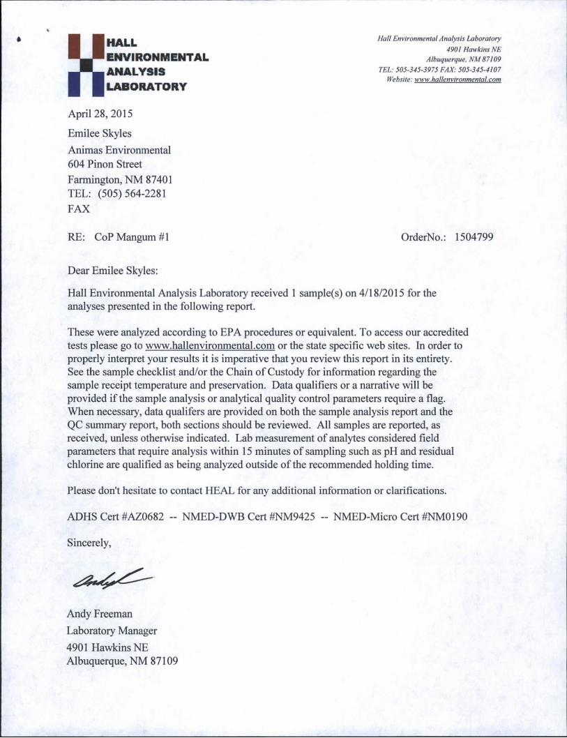
April 28, 2015
Emilee Skyles
Animas Environmental 604 Pinon Street
Farmington, NM 87401 TEL: (505)564-2281 FAX
RE: CoP Mangum #1 OrderNo.: 1504799
Dear Emilee Skyles:
Hall Environmental Analysis Laboratory received 1 sample(s) on 4/18/2015 for the analyses presented in the following report.
These were analyzed according to EPA procedures or equivalent. To access our accredited tests please go to www.hallenvironmental.com or the state specific web sites. In order to properly interpret your results it is imperative that you review this report in its entirety.See the sample checklist and/or the Chain of Custody for information regarding the sample receipt temperature and preservation. Data qualifiers or a narrative will be provided if the sample analysis or analytical quality control parameters require a flag.When necessary, data qualifers are provided on both the sample analysis report and the QC summary report, both sections should be reviewed. All samples are reported, as received, unless otherwise indicated. Lab measurement of analytes considered field parameters that require analysis within 15 minutes of sampling such as pH and residual chlorine are qualified as being analyzed outside of the recommended holding time.
Please don't hesitate to contact HEAL for any additional information or clarifications.
ADHS Cert #AZ0682 - NMED-DWB Cert #NM9425 - NMED-Micro Cert #NM0190
Sincerely,
Andy Freeman
Laboratory Manager
4901 Hawkins NE Albuquerque, NM 87109
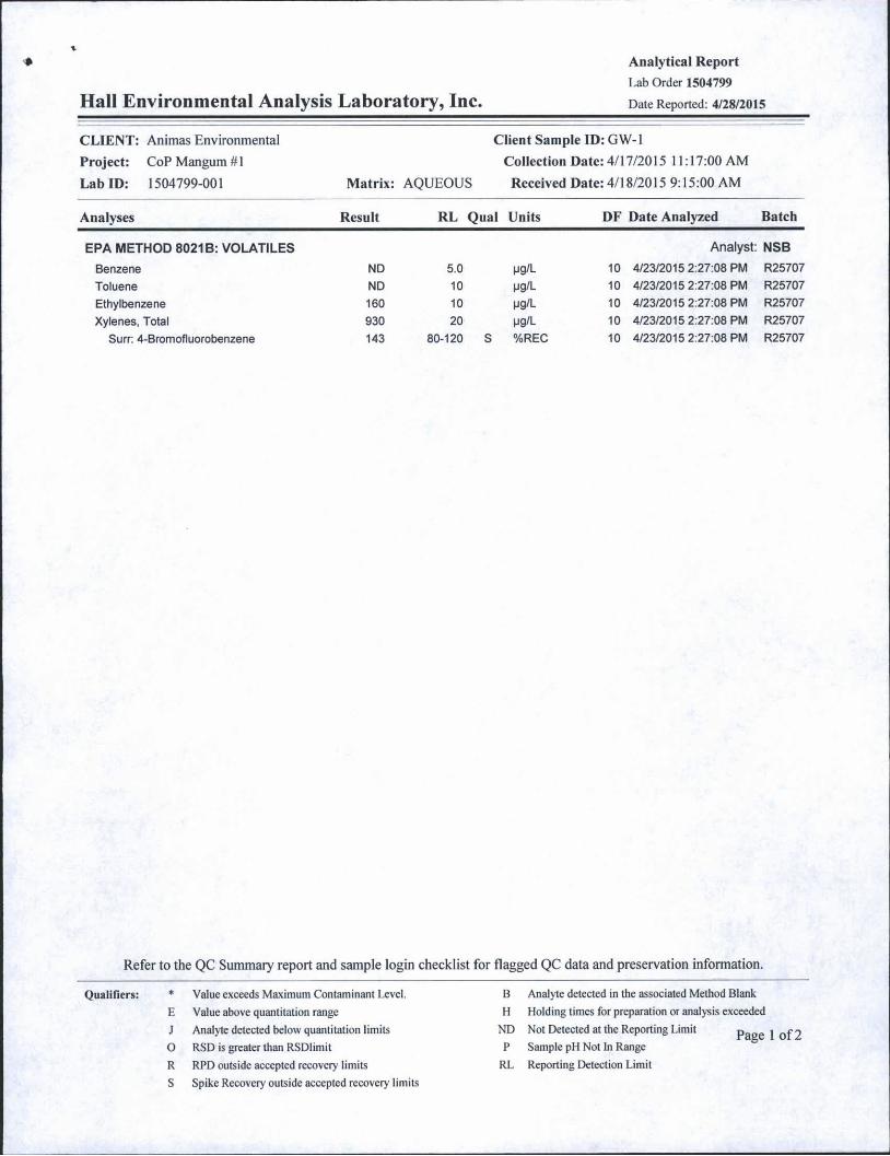
♦ Analytical Report
Lab Order 1504799
Hall Environmental Analysis Laboratory, Inc. Date Reported: 4/28/2015
CLIENT: Animas Environmental
Project: CoPMangum#l
Lab ID: 1504799-001 Matrix: AQUEOUS
Client Sample ID: GW-1
Collection Date: 4/17/2015 11:17:00 AM
Received Date: 4/18/2015 9:15:00 AM
Analyses Result RL Qual Units DF Date Analyzed Batch
EPA METHOD 8021B: VOLATILES Analyst: NSB
Benzene ND 5.0 mq/l 10 4/23/2015 2:27:08 PM R25707
Toluene ND 10 ug/L 10 4/23/2015 2:27:08 PM R25707
Ethylbenzene 160 10 mq/l 10 4/23/2015 2:27:08 PM R25707
Xylenes, Total 930 20 pg/L 10 4/23/2015 2:27:08 PM R25707
Surr: 4-Bromofluorobenzene 143 80-120 S %REC 10 4/23/2015 2:27:08 PM R25707
Refer to the QC Summary report and sample login checklist for flagged QC data and preservation information.
Qualifiers: * Value exceeds Maximum Contaminant Level.
E Value above quantitation rangeJ Analyte detected below quantitation limits O RSD is greater than RSDlimit R RPD outside accepted recovery limits S Spike Recovery outside accepted recovery limits
B Analyte detected in the associated Method Blank H Holding times for preparation or analysis exceeded
ND Not Detected at the Reporting Limit P Sample pH Not In Range
RL Reporting Detection Limit
Page 1 of2
V
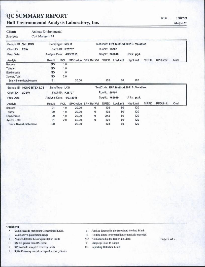
QC SUMMARY REPORTHall Environmental Analysis Laboratory, Inc.
WO#: 150479928-Apr-15
Client: Animas EnvironmentalProject: CoP Mangum #1
Sample ID 5ML RBB SampType: MBLK TestCode: EPA Method 8021B: Volatiles
Client ID: PBW Batch ID: R25707 RunNo: 25707
Prep Date: Analysis Date: 4/23/2015 SeqNo: 762048 Units: pg/L
Analyte Result PQL SPK value SPKRefVal %REC LowLimit HighLimit %RPD RPDLimit Qual
Benzene ND 1.0Toluene ND 1.0
Ethylbenzene ND 1.0
Xylenes, Total ND 2.0Sum 4-Bromofluorobenzene 21 20.00 103 80 120
Sample ID 100NGBTEXLCS SampType: LCS TestCode: EPA Method 8021B: Volatiles
Client ID: LCSW Batch ID: R25707 RunNo: 25707
Prep Date: Analysis Date: 4/23/2015 SeqNo: 762049 Units: pg/L
Analyte Result PQL SPK value SPK Ref Val %REC LowLimit HighLimit %RPD RPDLimit Qual
Benzene 21 1.0 20.00 0 105 80 120
Toluene 20 1.0 20.00 0 102 80 120
Ethylbenzene 20 1.0 20.00 0 99.2 80 120
Xylenes, Total 61 2.0 60.00 0 101 80 120
Sum 4-Bromofluorobenzene 20 20.00 103 80 120
Qualifiers:
* Value exceeds Maximum Contaminant Level. B
E Value above quantitation range H
J Analyte detected below quantitation limits ND
O RSD is greater than RSDIimit P
RS
RPD outside accepted recovery' limitsSpike Recovery outside accepted recovery limits
RL
Analyte detected in the associated Method BlankHolding times for preparation or analysis exceeded
Not Detected at the Reporting Limit Page 2 of 2Sample pH Not In RangeReporting Detection Limit
HHALLENVIRONMENTALANALY8I8LABORATORY
Halt Environmental Analysis Laboratory
4901 Hawkins HE Albuquerque, AM 87109
TEL: 505-345-3913 FAX: 505-345-4107 Website: wu wJutUettvironmeuktl com
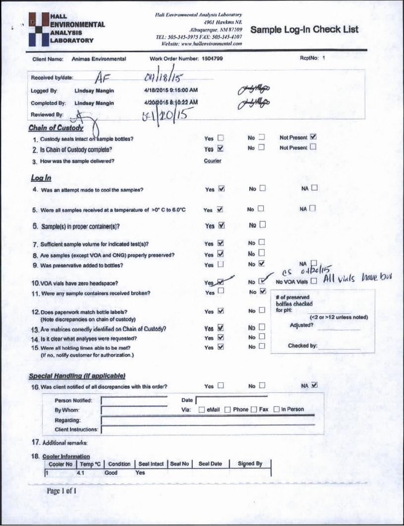
Sample Log-In Check List
Work Order Number. 1504799whtht
4/18/2015 9:1600 AM
4/26£015 8: jO 22 AM
ti-WVS'
Client Name: Animas Environmental
Received ty/date; itf
Logged By Lindsay Mangin
Completed By: Lindsay Mangin
Reviewed By
Chain of Custody1. Custody seals Intact sample bottles?
2. Is Chain of Custody complete73. How was the sample delivered?
Logjn4 Was an attempt made to cool the samples?
5. Were all samples received at a temperature of >0* C to 6 0*C
6. Sample(s) in prop* containers)?
7. Sufficient sample volume for indicated test(s)?
8. Are samples (except VOA and ONG) properly preserved?
9. Was preservative added to bottles?
10. VOA vials have zero headspase?
11. Were any sample containers received broken?
12. Does paperwork match bottle labels?(Note discrepancies on chain of custody)
13. Are matrices conedty identified on Chain of Custody?
14 . IS it dear What analyses were requested?15 Were all holding times able to be met?
(If no. notify customer for authorization )
Special Handling (if applicable)16. Was client notified of alt discrepancies with this order?
RcptNo: 1
Yes □ No □ Not Present 0
Yes 2 No □ Not Present □
Courier
Yes 0 No □ NA □
Yes No □ na n
Yes ® NO □
Yes 0 No □
Yes 0 No □
Yes U
Yes r 1
No 0 NA U ; ^^ o-lfcllb
No 1 S No VOA Vials □ All Vkfc W*
No SO# of preserved bottles checked
Yes Si No □ for pH:(<2 or >12 unless noted)
Yes £
Yes 0
No □ Adjusted?
No □
Yes 0 No □ Checked by:
Yos □ No □ NA 0
Person Notified:
By Whom
Regarding:
Client Instructions
Date f”
Vra: D eMail □ Phone □ Fax □,n pe**on
17. Additional remarks
18. Cppiyr fnfrrroaitenCooler No 1 Temp “C | Coid t ion | Seal Intact | Seal No | Seal Date | Signed By
[i—^rr— Good Yes
Page I of I

Turn-Around Time:Chain-of-Custody RecordClient: Animas Environmental Services, LLC X Standard □ Rush
Project Name:
Mailing Address: 6Q4 w pjnon gtCoP Mangum #1
Farmington, NM 84701 Project #:
Phone #: 505-564-2281
Email or Fax#: eskvles(®animasenvironmental.corr Project Manager:QA/QC Package:
X Standard □ Level 4 (Full Validation)
Accreditation: □ NELAP □ Other□ EDD (Type)
Date
4/17/15
Time
11:17
Matrix
-Seit-fc i
Sample Request ID
GW-1
HALL ENVIRONMENTAL ANALYSIS LABORATORY
www.hallenvironmental.com
4901 Hawkins NE - Albuquerque, NM 87109
Tel. 505-345-3975 Fax 505-34^4107
Analysis Request
Emilee Skyles
Sampler E. Skyles/D. Davis
Container Type and #
3 - 40 mL VOA
PreservativeType
HCI -CO
COcsjoco
XLLi
HCD
OOCO
I</><D
'k-o
SZO
Date: Time:
jlnli£Relinquished by:
Date:
aTime:
nk \«ttb
Relinquished by:
Received by: Date Time
(I ft I It'
Date Time
y/H/rr fi />
Remarks: Bill to Conoco Phillips Work Order #20726109 User: KG ARC IA Supervisor Ervin Wyckoff Area: 22Ordered by: Allison Maxwell
If necessary, Samples submitted to Hall Environmental may be subcontracted to other accredited laboratories. This serves as notice of this possibility. Any sub-contracted data will be dearly notated on the analytical report.