Embed Size (px)
Citation preview
Staff Report: Z-19-14-3 July 8, 2014
North Mountain Village Planning Committee Meeting Date
July 16, 2014
Planning Commission Hearing Date August 12, 2014
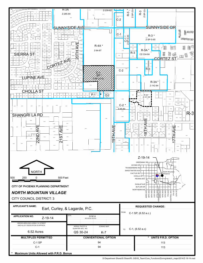
Request From: C-1 SP (6.52 Acres) Request To: C-1 (6.52 Acres) Proposed Use Removal of Special Permits Z-SP-9-98 and
Z-SP-22-02 to allow the underlying C-1 uses. Location Northwest corner of 19th Avenue and Cholla
Street Owner Phoenix 2006 Partners LLC Applicant and Representative Earl, Curley, & Lagarde, P.C. Staff Recommendation Approval
General Plan Conformity
General Plan Land Use Designation Commercial
Street Classification Map 19th Avenue Major Arterial 55-foot half-street width
Cholla Street Minor Collector 40-foot half-street width
NEIGHBORHOOD ELEMENT, GOAL 2, POLICY 3: CREATE NEW DEVELOPMENT THAT IS SENSITIVE TO THE SCALE AND CHARACTER OF THE SURROUNDING NEIGHBORHOODS AND INCORPORATES ADEQUATE DEVELOPMENT STANDARDS TO PREVENT NEGATIVE IMPACT(S) ON THE RESIDENTIAL PROPERTIES.
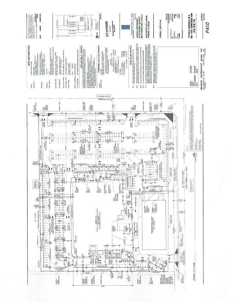
Public vehicular access to the subject parcel is provided by 19th Avenue, a Major Arterial street. The applicant is proposing a driveway off of Cholla Street to only be utilized for Fire Department and trash collection purposes. This will mitigate any traffic that may cut-thru the neighborhood located to the west of the site. A stipulation from Z-SP-22-02 only permits access onto 19th Avenue. In order to access Cholla Street, a stipulation modification through the Planning Hearing Officer process is required.
LAND USE ELEMENT, GOAL 2: POLICY 2: LOCATE MAJOR TRAFFIC-GENERATING LAND USES ON MAJOR STREETS IN AREAS PLANNED FOR SUCH USES, OR NEAR PARKWAY AND FREEWAY ACCESS AND TRANSIT CENTERS OR LIGHT RAIL TRANSIT STATIONS, AND AVOID USE OF LOCAL STREETS.
The subject site is located along an arterial street and in proximity to a highway. With the proposed vehicular access limited to 19th Avenue there are no negative impacts anticipated on the adjacent area as a result of additional traffic generated by future uses.
Staff Report: Z-19-14-3 July 8, 2014 Page 2 of 5
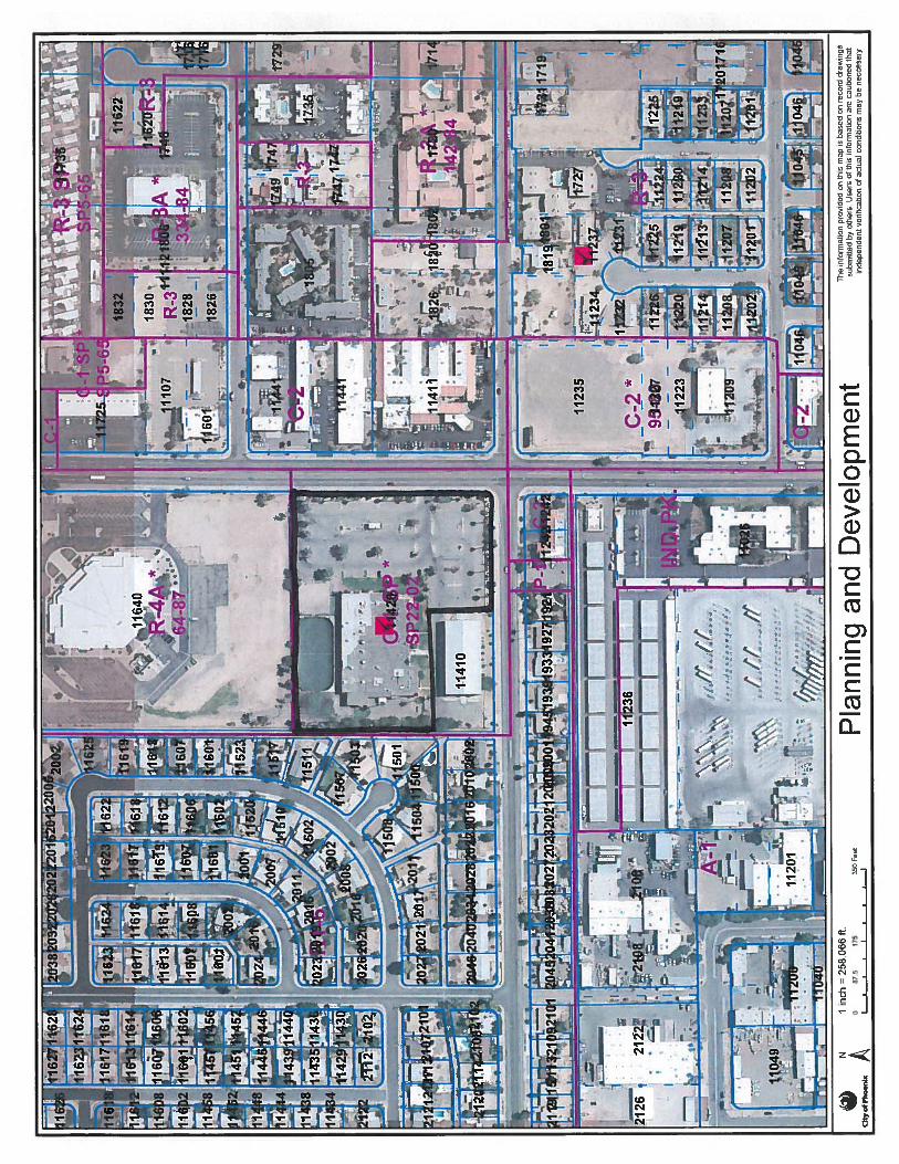
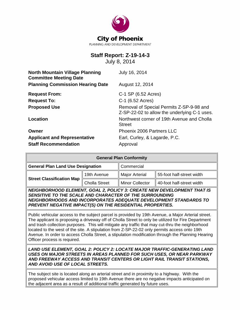
Surrounding Land Uses/Zoning
Land Use Zoning On Site Sports Facility C-1 SP North Church R-4A South Volley Ball Facility, Single-Family Residential,
Parking, and Commercial/Retail/Office C-1 SP, R1-6, P-1, C-2
East Commercial/Retail C-2 West Single-Family Residential R1-6
C-1 (Neighborhood Commercial)
Standards Requirements Proposed Building Setbacks Street Average 25 feet (Peoria Ave)
Average 25 feet (Cholla St) Met – 98 feet Met – 183 feet
Side 0 feet (south) 25 feet (west) 10 feet (north)
Met – 28 feet Met – 53 feet Met – 121 feet
Landscape Setbacks Street (south) Average 25 feet Met – 25 feet Side (east) 0 feet Met – 0 feet Rear and side (north, west) 0 feet Met – 0, 25 feet Lot Coverage Maximum 50% Met – 27.4% Building Height Maximum 30 feet Met – 28 feet Parking Minimum 230 required Met – 386 provided Background/Issues/Analysis 1. The purpose of this request is to remove
a Special Permit to allow for office uses and all underlying C-1 uses. The subject site is located at the northwest corner of 19th Avenue and Cholla Street. The property was rezoned to Neighborhood Commercial Special Permit (C-1 SP) to allow for the development of a sports complex.
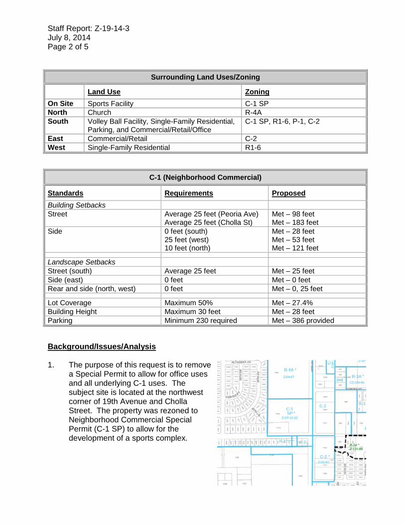
Staff Report: Z-19-14-3 July 8, 2014 Page 3 of 5 2. The proposed
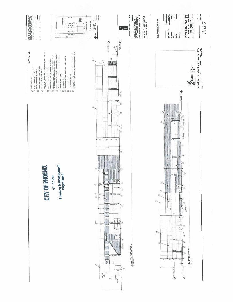
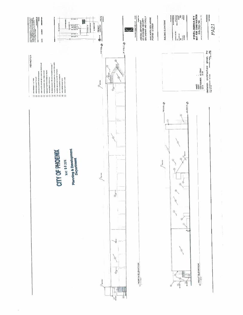
development is consistent with the intensity and character of the existing commercial properties to the east along 19th Avenue and a portion of the south along Cholla Street, as well as the large church located north of the subject site. The uses to the west and a portion of the south are single-family residential developments. The proposed building and site improvements to the site are occurring at the east side of the existing building.
3. The General Plan depicts the subject parcel as Commercial. The request is
consistent with the land uses in the area. 4. The current C-1 Special Permit entitlement (Z-SP-22-02) was approved in 2002 for
the southern portion of the subject site to allow for the development of a sports complex. The Mayor and Council at that time approved the request subject to the following stipulations: 1) That development shall be in general conformance with the site plan date April
11, 2002 as approved or modified by the Development Services Department. 2) That use of the sports complex shall be for members and for tournaments and
fund raising/community events using the site for recreational purposes. 3) There shall be no entertainment or public assembly use of the site except as
related to the recreational facilities and activities provided. 4) That ingress and egress shall be limited to the 19th Avenue frontage. 5) That all west and south facing doors of the volleyball facility shall remain closed
during volleyball practice and tournament events. 6) That no lighting, except for wall-mounted security lighting, shall be placed on the
west and south sides of the (volleyball) building.
Staff Report: Z-19-14-3 July 8, 2014 Page 4 of 5
Stipulation #4 limited vehicular access to the site from 19th Avenue only. The intent was to mitigate and limit any traffic that may cut-thru the neighborhood located to the west of the subject site. The proposed site plan is showing access to the site on 19th Avenue and Cholla Street. The two points of access along 19th Avenue provide access to 379 of the 386 parking spaces that are located at the east and north of the building and it should follow that these parking spaces will be utilized by employees and customers of the facility. The site plan shows a proposed new drive on Cholla Street, however, such improvements are not located within the subject request. The proposed new drive off of Cholla Street is located within the property shown on the site plan as “Existing Volleyball Facility” and is not part of this request. This property will remain subject to the original Special Permit Case No. Z-SP-22-02, with stipulations. Stipulation #4 from Z-SP-22-02 requires ingress/egress be limited to 19th Avenue. This stipulation would need to be modified through the Planning Hearing Officer process to provide this access.
5. The current request to remove the Special Permit from the subject site will still retain
the established C-1 Neighborhood Commercial base zoning. With this request the applicant may utilize any of the C-1 uses outlined in the Zoning Ordinance.
6. The proposed removal of the Special Permit (Z-SP-22-02) is not being requested for
the south western portion of the site, shown as the “Existing Volleyball Facility” on the site plan. This original Special Permit case and its stipulations will be retained and enforced on the southwest portion of the site.
7. The proposed site plan shows the modification of an existing building. The
modifications include façade and front-of-house renovations which include a new plaza and building entrance, concrete walks, additional building landscaping, and parking configurations. The total building area is 65,773 square feet which will be used as office. The site plan also shows a 25-foot landscape setback along both 19th Avenue and Cholla Street with primary vehicular access being provided off of 19th Avenue.
8. The Street Transportation, Water Services, and Fire Departments have stated that
there are no issues with this request. 9. Development and use of the site is subject to all applicable codes and ordinances.
Zoning approval does not negate other ordinance requirements. Other formal actions such as, but not limited to, zoning adjustments and abandonments, may be required.
Findings 1. The proposal is consistent with the land use pattern in the area. 2. The proposed commercial uses are appropriately located along an arterial street
and in proximity to an interstate freeway.
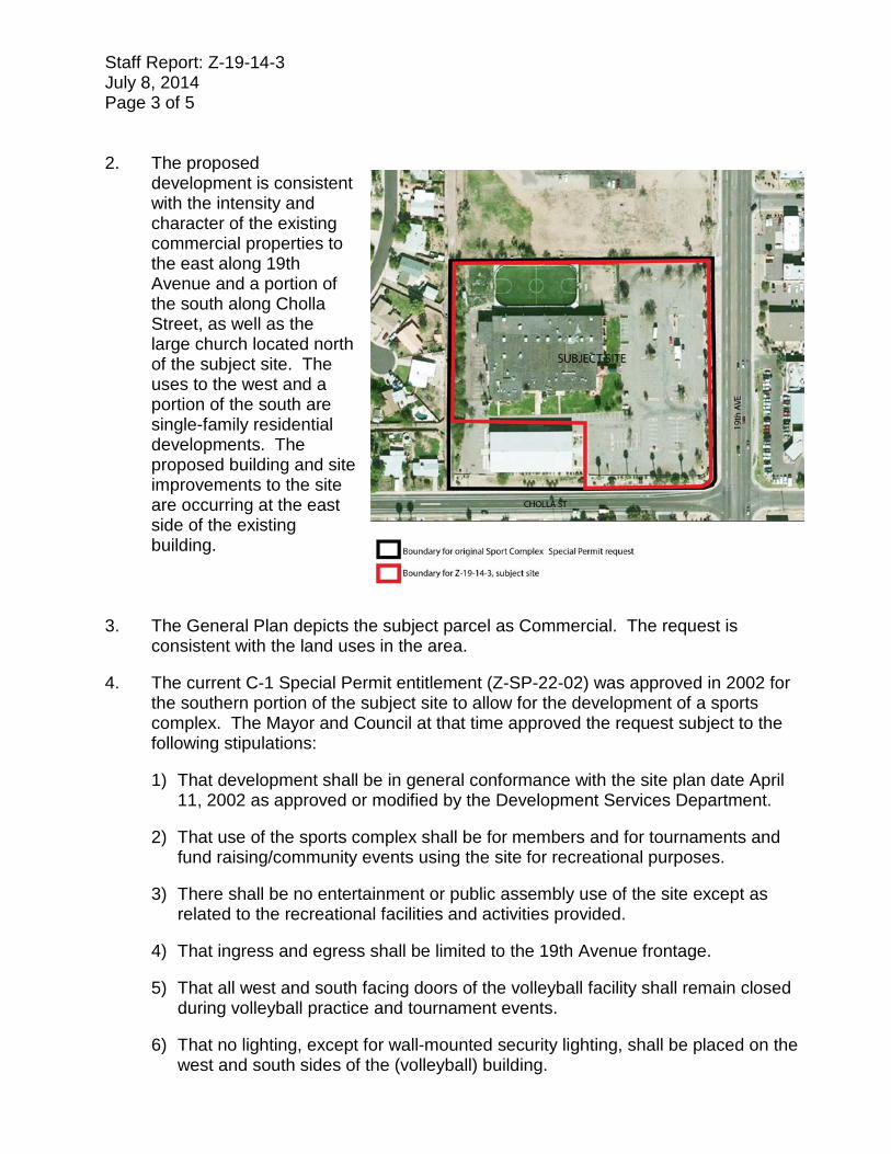
Staff Report: Z-19-14-3 July 8, 2014 Page 5 of 5 Stipulations N/A Writer Ray Brown 07/08/14 Team Leader Joshua Bednarek Attachments Sketch Map Aerial Site Plan date stamped May 8, 2014 Elevation date stamped May 8, 2014
* Maximum Units Allowed with P.R.D. Bonus
APPLICANT'S NAME:
DATE:REVISION DATES:
REQUESTED CHANGE:
GROSS AREA INCLUDING 1/2 STREETAND ALLEY DEDICATION IS APPROX. AERIAL PHOTO &
QUARTER SEC. NO.ZONING MAP
MULTIPLES PERMITTED CONVENTIONAL OPTION * UNITS P.R.D. OPTION
FROM:
TO:
CITY COUNCIL DISTRICT:
NORTH
GREENWAY RD
CACTUS RD
PEORIA AVE
43RD
AVE
DUNLAP AVE
NORTHERN AVE
35TH
AVE
INTE
RSTA
TE 17
7TH A
VECE
NTRA
L AVE
39TH
AVE
31ST
AVE
27TH
AVE
23RD
AVE
19TH
AVE
15TH
AVE
7TH
ST12
TH S
T
BUTLER DR
CHOLLA ST
SWEETWATER AVETHUNDERBIRD RD
ACOMA DR
North MountainPreserve
Arizona Canal
§̈17¦
APPLICATION NO.
CITY OF PHOENIX PLANNING DEPARTMENTCITY OF PHOENIX PLANNING DEPARTMENT
Earl, Curley, & Lagarde, P.C.Z-19-14
6.52 Acres
5/19/14
QS 30-24 K-7
NORTH MOUNTAIN VILLAGE3
Z-19-14
R-3A
C-1
P-1 C-2
R-3
R-3
R-3A
C-1
C-2
C-2
C-2
C-1
R-4A
R-3 R-3A
R-5
SPR-3
R-3Z-95-80
Z-SP-5-65
Z-64-87
Z-285-84
Z-SP
-23-69
CZ-334-84
Z-SP
-23-69
Z-SP
-5-65
Z-239-82
Z-142-84
Z-SP-22-02*
*
*
*
*
*
**
* *
18TH
AVE
CHOLLA ST
CORTEZ AVE
17TH
AVE
CORTEZ STSIERRA ST
SUNNYSIDE AVE
SHANGRI LA RD
20TH
AVE
SUNNYSIDE DR
LUPINE AVE
19TH
AVE
22ND
AVE
21ST
AVE
R-3A *Z-121-84
1181111829
1601 1601
1601
1601 1601
160116
01
1601
1601
1601
17161716
1601
16011601
160116
0116
011601
17161716
1716
1716
171617161716
17161716
1716
1716
1716
1716
1716
1716
1716
1716
1716 1716
171617161716
1716
1716
1716
1716
1716
1716 1716
17161716
1716
1716
17161716
1720
1714 1708
1747 1747
1735
1749 1747
11255
11405
1716 1716
1716 1716
11242
11223
11227
11235
11411
11441
11441
11232
11234
1827
18261826
11214
11220
11226
1805
11237
1820
1819
11213
11219
11225
11231
1801
1802
1727
11214
11220
11224
11207
11233
11219
11225
1721
1720
1719
1716
1717
1712 1706
11230
11238
1703
11214
11222
1652
1653
11229
11235
1646
1647
1642
1642
1641
1632
1634
11222
1722
17321726
11034
1103611034 11033
11038 11037
1104211042 11041
1104611046 11045
17021120111201
11207
11046
11042
1802
11038
11032
1750
11208
11033
11041
11045
11037
11209
11017
1102111027
11009
11035
11034
11038
11042
11046
1834
11202
11208
11033
11041
11045
11037
1830
11003
1638 1634 1630
1626
11009
11019
1649 1625
11001 1702
2002
1944 11802
11801
11818
11812
11725
11735
11747
1832 11622
16011601
1601
1601160116011601
16011601
1601
1601
1601
1716
1601
1601
1601
1601
16011601
1601
1601
1601
1716 1716
171617161716
1716
1716
17161716
171611607
11613
11617
11623
2038
2045 2039
2032
11608
11614
11618
11624
2033
2028
2029
2022
11601
11607
11107
1826
1830
1111
2
1806
1748
11620
1716
17161716
1716
1716
1716
1716
1716
11640
1160111601
1160611607
1161211613
11613
1161811617
11619
1162211623
11625
20022016 2012 2006
2023 2017 2013 2007 2001
2121
2124
2122
2118
2117
2118
2111
2114
2112
2108
2107
2108
2102
2101
2142
2141
2144
2135
2138
2138 2134
2133
2132
2128
2127
2128
220822172202
22132207
22012147
2224
22182212 2208 2202 21482217
2212
2207
11632
11636
2202
22012137
1164011635
2133
11631
11625
2129
11626
11632
11638
11642
11648
11623
11627
11633
11637
11643
11649
11624
11628
11634
11638
11644
11650
2231
2232
2233
2230
2226
2225
2226
2227
2226
2218
2221
2222
2223
2220
2212
2217
2218
2217
2216
2213
2211
2212
11457 1145611458
11601 1160211602
2208 22022111 11608 11607 11608
2107 116122207 2201
11613 11614
2101 11618 11617 11618
11440
11446
11452
2026
2023
2024
11601
2019
2020
20162002
2015
2016
2011
2008
2007
2002
11502
11510
11520
11602
2202 2148 2142 2138 2132
22072201
21452141
2137
22022131
2130
22112127
2126
2220
2227
2218
2221
2216
2221
2212
2217
2217
2212
2208
2213
2102
2101
2046
2027 2021
2040
2017
2034
2011
2028 2022
11508
11504
2132 2126 2120 2114 2108
2131 2127 2121 2117 2113 2107
2128 2122 2112 2102
11429 1143011434
1143511438
1143911444
1144511448
1145111452
2224
2218 2214 2210 2202 2144 2140 2138
2221
2217 2213 2207 2201 2145 2141 2137
2016
11507
11500
2010
11503
11511
11501
11517
11523
2002
1945
11410
11420
19391933 1927
1921
11242
2240
2223 2219
2236
2213 2207
2224
2201 2145 2141
2220
2135 2131 2125
2126
2119 2115
2122
2113 2109 2101
2108
2045 2041
2108
2039
11023 11024
2239 2231 2221
11028 11028
11030
1103611040
11049
11200
11050
2030
2010
11002
11021
11026
11035
11201
11236
2033 2027 2023 2021 2015 2009 2001
2240 2224
2210 11010
11024
500 0 500250 Feet
C-1 SP 94 113C-1 94 113
C-1, (6.52 a.c)
C-1 SP, (6.52 a.c.)
S:\Department Share\IS Share\PL GIS\IS_Team\Core_Functions\Zoning\sketch_maps\2014\Z-19-14.mxd