Embed Size (px)
Citation preview
United StatesDepartment ofAgriculture
Service CenterModernization Initiative(SCMI)
Standard for Geospatial Dataset FileNaming
Prepared byData Management Team #5: Geospatial Data Standards
Abstract: This document provides the USDA Service Center ModernizationInitiative standard for geospatial directory and file naming conventions. Itdescribes the conventions used for the basic nationally consistent set of coregeospatial data, locally acquired geospatial data and derived geospatial data.
Keywords: geospatial data, GIS, file naming, standard
Published and distributed on January 25, 2001(Revision of Standard for Geospatial Dataset File Naming: SCI Std 004-01, August 31, 2000)
Document number: SCMI Std 004-02
JANUARY 25, 2001 DRAFT STANDARD FOR GEOSPATIAL DATASET FILE NAMING
SCMI Std 004-02 ii
Introduction
As directed by the Secretary of Agriculture’s March 16, 1998 memorandum, the NaturalResources Conservation Service (NRCS), Farm Service Agency (FSA), and RuralDevelopment (RD) agencies are co-locating offices, modernizing business processes, andpartnering to achieve a “one-stop service” for United States Department of Agriculture(USDA) customers at their county-based field offices (Service Centers). One of the majorcomponents of the modernization initiative involves the implementation of a GeographicInformation System (GIS) across each of the Partner Agencies and in all 2,550 ServiceCenter offices. A Service Center Data Team has been chartered with the overallresponsibility for implementing an infrastructure for management of data resources forthe Partner Agencies. The GIS Standards Team 5 was formed to address specific datamanagement issues regarding geospatial data.
The individuals who contributed to the development of this standard are:
David Anderson, (NRCS) Service Center Data Team LeaderCarol Ernst, (FSA) Co-Leader
Emil Horvath, (NRCS) Co-Leader
Liz Cook (NRCS) Rodney Johnson (FSA) Ron Selph (NRCS)Dwain Daniels (NRCS) Dave Nabidy (FSA) Phil Teague (NRCS)Larry Davis (NRCS) Steve Nechero (NRCS) Rob Vreeland (NRCS)Randy English (NRCS) Elaine Ortiz (NRCS) Nicole Soltyka(SAIC)Kent Williams (FSA) Jill Schuler (NRCS) Randy Frosh (Unisys)
Working group list
ARC/INFO is a registered trademark of Environmental Systems Research Institute, Inc.ArcView is a registered trademark of Environmental Systems Research Institute, Inc.Microsoft Access 97 is a registered trademark of Microsoft Corporation.Microsoft Access 2000 is a registered trademark of Microsoft Corporation.MrSid is a registered trademark of LizardTech, Inc.
JANUARY 25, 2001 DRAFT STANDARD FOR GEOSPATIAL DATASET FILE NAMING
SCMI Std 004-02 iii
Table of contents
1. Overview ............................................................................................................................... 11.1. Scope...................................................................................................................... 11.2. Purpose................................................................................................................... 11.3. Acronyms and abbreviations.................................................................................. 2
2. Background ........................................................................................................................... 33. Geospatial dataset collection ................................................................................................ 34. Geospatial dataset category ................................................................................................. 4
4.1. Geospatial dataset category naming....................................................................... 55. Geospatial dataset ................................................................................................................ 5
5.1. Geospatial dataset naming ..................................................................................... 56. Standard characters.............................................................................................................. 6
6.1. Special characters................................................................................................... 66.2. Case sensitivity ...................................................................................................... 66.3. Allowable standard characters ............................................................................... 7
7. Name length.......................................................................................................................... 78. Area of interest...................................................................................................................... 89. Local data.............................................................................................................................. 8
9.1. Existing "geospatial dataset category"................................................................... 89.2. "Local_geodata" catchall directory........................................................................ 99.3. Local data naming.................................................................................................. 9
10. Geospatial data directory structure: "geodata" ..................................................................... 910.1. Overview .......................................................................................................... 1010.2. Table notations ................................................................................................. 10
Appendix A − Bibliography............................................................................................................. 18Appendix B − Business Process Reengineering directory structure ............................................. 19

JANUARY 25, 2001 DRAFT STANDARD FOR GEOSPATIAL DATASET FILE NAMING
SCMI Std 004-02 iv
This page is intentionally left blank
JANUARY 25, 2001 DRAFT STANDARD FOR GEOSPATIAL DATASET FILE NAMING
SCMI Std 004-02 1
STANDARD FOR GEOSPATIAL DATASET FILE NAMING
1. Overview
The objectives of this standard are to help in managing United States Department ofAgriculture (USDA) Service Center Modernization Initiative (SCMI) geospatial data byestablishing directory (folder) and file naming conventions; support the concurrentUSDA Service Center Modernization Strategy to develop a basic nationally consistent setof core geospatial data that will provide a foundation on which to base businessapplications; and to relate to other SCMI geospatial standards including SCMI Std 003,Standard for Geospatial Data Set Metadata [A2]1, SCMI Std 005, Standard forGeospatial Feature Metadata [A3], SCMI Std 007, Standard for Geospatial Data [A4],and the USDA Service Center Initiative Directory Structure and File Naming ConventionChange Control Policy [A6].
This standard contains two appendices. Appendix A provides bibliography references.Appendix B contains the initial directory and naming conventions established for theBusiness Process Reengineering (BPR) pilot sites.
1.1. Scope
The scope of this standard is to define the directory and file naming conventions for thegeospatial dataset collection (physical repository of data) that resides at a Service Center.This standard shall apply to the set of nationally consistent core geospatial data layersfirst defined in the USDA Service Center Geographic Information System (GIS) Strategy[A5]. It also provides standards on the directory structure and file naming for locallyacquired and derived geospatial data. This document replaces the initial directory andnaming conventions established for BPR pilot sites known as version 5 (See AppendixB).
1.2. Purpose
GIS for the Service Center is expected to comprise nationwide coverage of more than 20common geospatial datasets (a group of similar spatial phenomena) that are collected anddistributed at the county level of geography. To organize this data at the Service Centerso that it is accessible, maintainable and updateable requires a standard scheme forcategorizing the data into directories and establishing names and conventions for the filesin the directories.
This standard will continue to evolve as nationally consistent datasets are provided to theService Centers. However, this document is an initial attempt to identify the directoriesand file names for existing common geospatial dataset categories and it helps to establishinitial standards and direction for BPR projects that require geospatial data.
1 The number in brackets corresponds to those of the bibliography in Appendix A.
JANUARY 25, 2001 DRAFT STANDARD FOR GEOSPATIAL DATASET FILE NAMING
SCMI Std 004-02 2
This standard will be placed under configuration management and maintained through astructured change control process because the impact of changing this standard can begreat on those applications that use the data and those who provide the data. The changecontrol process will allow proposed changes to be reviewed and discussed by thoseaffected by the change.
Nationally fielded applications will be developed that rely on the nationally consistent setof geospatial data. These applications will rely on the integrity of the data in meeting thespecifications in this standard. Applications that are built locally for a Service Center orfor data that is acquired locally shall adhere to these standards.
1.3. Acronyms and abbreviations
BPR Business Process ReengineeringCCE Common Computing EnvironmentCD-ROM Compact Disc Read Only MemoryCLU Common Land UnitDEM Digital Elevation ModelDLU District Land UnitDMF Digital Map FinishingDOQ Digital Ortho QuadrangleDOQQ Digital Ortho Quarter QuadrangleDRG Digital Raster GraphsEPA Environmental Protection AgencyFEMA Federal Emergency Management AgencyFIPS Federal Information Processing StandardFSA Farm Service AgencyFWS Fish and Wildlife ServiceGIS Geographic Information SystemGNIS Geographic Names Information SystemISO International Standards OrganizationMDOQ Mosaicked Digital Ortho QuadranglesMLRA Major Land Resource AreasMrSID Multi-resolution Seamless Image DatabaseNAPP National Aerial Photography ProgramNASIS National Soil Information SystemNCGC National Cartography and Geospatial CenterNRCS Natural Resources Conservation ServiceNWI National Wetland InventoryOIP Office Information ProfileRD Rural DevelopmentSSA Soil Survey AreaSCMI Service Center Modernization InitiativeSSURGO Soil Survey Geographic DatabaseSTSSAID State Soil Survey Area IDTIF Tagged Image FileUS United States
JANUARY 25, 2001 DRAFT STANDARD FOR GEOSPATIAL DATASET FILE NAMING
SCMI Std 004-02 3
USDA United States Department of AgricultureUSGS United States Geological SurveyUTM Universal Transverse MercatorWRP Wetland Reserve Program
2. Background
The USDA Service Center Geographic Information System (GIS) Strategy [A5] firstdefined a list of geospatial datasets required to provide a foundation on which to basebusiness applications. The Geospatial Data Acquisition, Integration, and DeliveryNational Implementation Strategy Plan [A1] further refined and expanded this list. Thislist was organized into logical categories based on business names. It is these logicalcategories that form the basis for the organization of the physical directory structuredefined in this standard.
The SCMI Std 007, Standard for Geospatial Data [A4] includes a geospatial data modelthat details a hierarchical classification that shall be used to categorize, or providetaxonomy for, geospatial data. These categories are referred to as geospatial datasetcategories. This model and classification shall be used to identify and describe geospatialdata in a consistent way. The geospatial dataset categories in the model are used as thebasis for the directory structure in this document.
The top level of the geospatial data model is referred to as a geospatial dataset collection.A geospatial dataset collection is a catalog and physical repository of geospatialdatasets. For example, an USDA data mart that serves geospatial data to only one ServiceCenter, or an USDA national data warehouse that serves geospatial data to all ServiceCenters is a geospatial dataset collection.
This standard is based on the lessons learned during the initial fielding of geospatialdatasets at the pilot sites (see Appendix B). In addition to creating a flatter directorystructure, each dataset name within each geospatial dataset category was examined inorder to provide a consistent naming convention that would offer a standard method ofdataset identification including name, data type and location. The directory structure andnaming conventions resulting from this examination follow in the subsequent sections.The geospatial data model is used as the basis for the directory structure in this document.
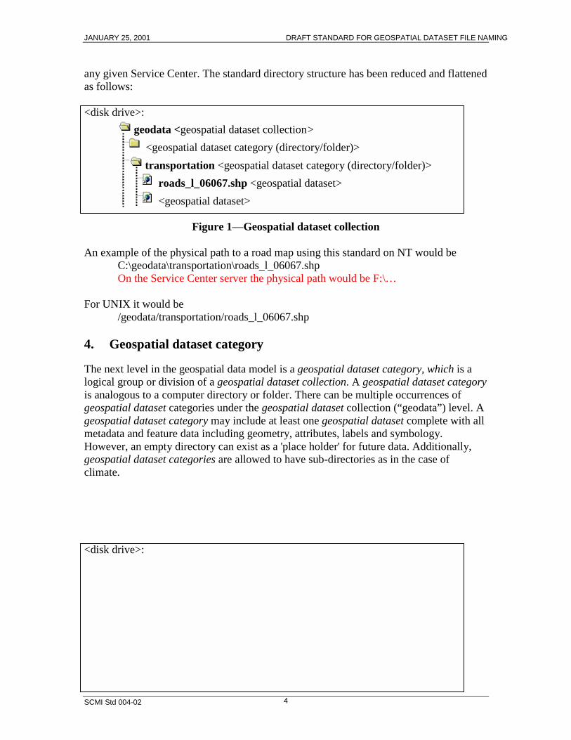
3. Geospatial dataset collection
The entire geospatial dataset collection at the top level of the directory shall be locatedon a designated drive and named "geodata". This replaces the previous top-level directory"Service Center Themes", the sub-directory named according to Service Center OfficeInformation Profile (OIP) number and name, and the sub-directories within that namedaccording to county (see Appendix B). Removing the Service Center and county levelsub-directory level simplified navigation but has ramifications on geospatial dataset filenaming which are discussed in 5.1. There shall be only be one “geodata” occurrence in
JANUARY 25, 2001 DRAFT STANDARD FOR GEOSPATIAL DATASET FILE NAMING
SCMI Std 004-02 4
any given Service Center. The standard directory structure has been reduced and flattenedas follows:
<disk drive>:geodata <geospatial dataset collection>
<geospatial dataset category (directory/folder)>transportation <geospatial dataset category (directory/folder)>
roads_l_06067.shp <geospatial dataset> <geospatial dataset>
Figure 1—Geospatial dataset collection
An example of the physical path to a road map using this standard on NT would beC:\geodata\transportation\roads_l_06067.shpOn the Service Center server the physical path would be F:\…
For UNIX it would be/geodata/transportation/roads_l_06067.shp
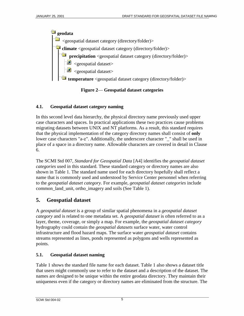
4. Geospatial dataset category
The next level in the geospatial data model is a geospatial dataset category, which is alogical group or division of a geospatial dataset collection. A geospatial dataset categoryis analogous to a computer directory or folder. There can be multiple occurrences ofgeospatial dataset categories under the geospatial dataset collection (“geodata”) level. Ageospatial dataset category may include at least one geospatial dataset complete with allmetadata and feature data including geometry, attributes, labels and symbology.However, an empty directory can exist as a 'place holder' for future data. Additionally,geospatial dataset categories are allowed to have sub-directories as in the case ofclimate.
<disk drive>:
JANUARY 25, 2001 DRAFT STANDARD FOR GEOSPATIAL DATASET FILE NAMING
SCMI Std 004-02 5
geodata<geospatial dataset category (directory/folder)>climate <geospatial dataset category (directory/folder)>
precipitation <geospatial dataset category (directory/folder)> <geospatial dataset>
<geospatial dataset> temperature <geospatial dataset category (directory/folder)>
Figure 2— Geospatial dataset categories
4.1. Geospatial dataset category naming
In this second level data hierarchy, the physical directory name previously used uppercase characters and spaces. In practical applications these two practices cause problemsmigrating datasets between UNIX and NT platforms. As a result, this standard requiresthat the physical implementation of the category directory names shall consist of onlylower case characters "a-z". Additionally, the underscore character "_" shall be used inplace of a space in a directory name. Allowable characters are covered in detail in Clause6.
The SCMI Std 007, Standard for Geospatial Data [A4] identifies the geospatial datasetcategories used in this standard. These standard category or directory names are alsoshown in Table 1. The standard name used for each directory hopefully shall reflect aname that is commonly used and understood by Service Center personnel when referringto the geospatial dataset category. For example, geospatial dataset categories includecommon_land_unit, ortho_imagery and soils (See Table 1).
5. Geospatial dataset
A geospatial dataset is a group of similar spatial phenomena in a geospatial datasetcategory and is related to one metadata set. A geospatial dataset is often referred to as alayer, theme, coverage, or simply a map. For example, the geospatial dataset categoryhydrography could contain the geospatial datasets surface water, water controlinfrastructure and flood hazard maps. The surface water geospatial dataset containsstreams represented as lines, ponds represented as polygons and wells represented aspoints.
5.1. Geospatial dataset naming
Table 1 shows the standard file name for each dataset. Table 1 also shows a dataset titlethat users might commonly use to refer to the dataset and a description of the dataset. Thenames are designed to be unique within the entire geodata directory. They maintain theiruniqueness even if the category or directory names are eliminated from the structure. The
JANUARY 25, 2001 DRAFT STANDARD FOR GEOSPATIAL DATASET FILE NAMING
SCMI Std 004-02 6
standard file names convey as much information as possible and reflect encoding into thename of
dataset theme type of map features in the dataset spatial location or extent of the dataset
As a result, the dataset name contains a short version or acronym used to represent the business name of the dataset feature type designation p-point, l-line, a-area, t-text, g-grid, r-raster, e-enhanced
Digital Raster Graphs (DRG), s-Multi-resolution Seamless Image Database(MrSID ), d-database/excel, i-index
location or extent information such as a Federal Information Processing Standard(FIPS) code or State Soil Survey Area ID (STSSAID) number
6. Standard characters
Because producers and consumers of geospatial data use computers with differentoperating systems, (e.g., NT, UNIX) several restrictions must be imposed on naming filesto ensure all systems can access the data. The application software often places otherrestrictions.
6.1. Special characters
In an effort to design a list of allowable characters both computer platform and GISsoftware filename restrictions must be considered. In terms of operating systems, NTdoes not allow the characters "\ / : * ? < >" in file names. Use of a "." can be problematicin NT as it indicates a file suffix.
UNIX allows any character but some of the characters in the preceding NT list can beproblematic. In addition using spaces in names or beginning a name with "-" isproblematic for UNIX. Beginning a name with "." in UNIX indicates a hidden file andrequires additional switches to the command that produces a directory listing.
The GIS currently in operation at the BPR sites allows dashes "-" and underscores "_" butnot periods ".". The full function GIS requires that a coverage name begins with a letter.
6.2. Case sensitivity
Use of upper and lower case characters in names is common and very useful in UNIX.However, this can be problematic with NT because it does not distinguish between a filenamed for instance "FileName" and "filename". On UNIX, the full function GIS convertsall names to lowercase. The desktop GIS converts all characters to lower case for a newshapefile name.
JANUARY 25, 2001 DRAFT STANDARD FOR GEOSPATIAL DATASET FILE NAMING
SCMI Std 004-02 7
6.3. Allowable standard characters
The allowable standard characters identified in this standard are based on the leastcommon denominator for both operating systems and software. This approach will notimpede any potential migration of geospatial datasets to a new platform or new softwareenvironment as technology and software enhancements are realized in the future.
Because of the combination of all these restrictions the only characters allowed in astandard file name are the following:
lower case a-z the numerals 0-9 the underscore "_" character the dash “-“ charter
In addition, the first character shall be a letter a-z.
These restrictions also shall apply to geospatial category or directory naming. Thesestandards are very restrictive and shall not change unless the GIS platform changes withfurther definition from the Common Computing Environment (CCE) Team.
7. Name length
The total length of the dataset filename shall not exceed 30 characters. This limit hasbeen identified during Compact Disc Read Only Memory (CD-ROM) production atNational Cartography and Geospatial Center (NCGC). The only CD-ROM writing formatthat is universally readable throughout Natural Resources Conservation Service (NRCS)is the International Standards Organization (ISO) 9660, Level 2, Mode 1 format.Exceeding this 30-character maximum for filenames becomes a problem when datasetsare sent via CD-ROM to multiple computer platforms.
However, no attempt is made to adhere to the so-called 8.3 format required by older DOSoperating systems (maximum of eight character name with a maximum of a threecharacter suffix). This will cause problems for Microsoft Access 97 and Access 2000because they can not import or link to .dbf files (such as those in a shapefile set) whosenames are longer than 8.3 until they are renamed with an 8.3 compliant name. (Note:Access requires 8.3 for imported and exported dbf files even though it will handle thelonger names.)
There is a 13 character maximum for coverages in the ARC/INFO GIS. This wasexceeded in this standard since it is designed to organize shapefiles and would prove to beeasier to use in the Service Centers because it will lessen the need for cryptic namesunfamiliar to many Service Center users. However, conversion of data either to or fromcoverages will require different names and additional processing.
JANUARY 25, 2001 DRAFT STANDARD FOR GEOSPATIAL DATASET FILE NAMING
SCMI Std 004-02 8
8. Area of interest
As mentioned previously the spatial location or extent is encoded into the name. In thecurrent scheme most maps will be clipped or tiled to the county boundary for deliveryand use unless the map is a state or national coverage. This clipped extent shall beappended to the theme name and feature type as a FIPS code or STSSAID number (e.g.,roads_l_06048.shp).
Tiling of digital geospatial data significantly impacts overall data management andsystem performance. In general, it is preferred that tiling is seamless, or transparent, tothe user.
Clipping map extents at the county boundary is not optimal for users if they for instancewish to look at a farm or an area that crosses a county boundary. Users would prefer to beable to zoom to some arbitrary area of interest and remain unaware of the underlyingdatabase structure or tiling scheme. However, this is not possible given the current stateof technology.
As a result, clipping the map data to the county boundary is the best available option fordelivery and maintenance of map data. This standard's encoded file naming scheme anddirectory structure ensures that maps of like datasets in adjacent counties will appear nextto each other in a pick list to facilitate user selection of maps.
In some cases, such as Digital Raster Graphs (DRG) and Digital Ortho Quadrangles(DOQ), an image catalog serves as an index map to 7.5-minute quad tiles for a county.This index is used to display images and conceals the underlying tiling scheme and imagefilenames from the user.
9. Local data
Any GIS data that is acquired or developed locally at the Service Center shall be placedin the geodata directory along with its completed metadata. A few guidelines are offeredto assist in the incorporation of this data in a logical and consistent manner.
9.1. Existing "geospatial dataset category"
If the data corresponds to one of the existing categories or directories, the map andmetadata should be placed in that directory so that it appears adjacent to any nationallyprovided data when the user is selecting from a pick list.
There are several circumstances where various types of local Service Center data shouldbe incorporated into the existing "geospatial dataset category" structure. They are
When there is no national data and only locally developed data, such as in thecase of Wetland Reserve Program (WRP) easements data. These maps along withthe Metadata should be placed in the environmental_easements directory or otherrelevant "geospatial dataset category" directories.
JANUARY 25, 2001 DRAFT STANDARD FOR GEOSPATIAL DATASET FILE NAMING
SCMI Std 004-02 9
When there are more accurate data from local sources the locally acquireddata should be placed in the appropriate "geospatial dataset category" directories.For instance, there is locally obtained road data that are known to be moreaccurate than the nationally provided data named roads_l_<stnnn>. The locallyacquired data and its metadata should be placed in the transportation directory anduniquely named according to the standard. One approach is to encode the datasetsscale into the filename. For instance, roads12k_l_<stnnn>, indicates that the roadmap is locally acquired 1:12,000 scale data.
When data are created locally as the result of analysis it should be placedunder the appropriate "geospatial dataset category" directory if the data would beuseful to others at a Service Center. The data should be named according to thestandard and placed in the appropriate geodata directory. Otherwise, the resultsshould be left on a personal disk drive where it is probably inaccessible to others.
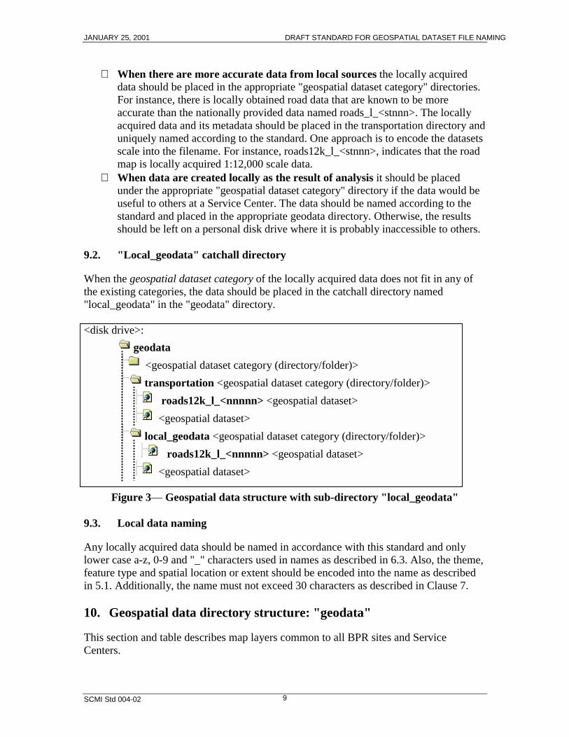
9.2. "Local_geodata" catchall directory
When the geospatial dataset category of the locally acquired data does not fit in any ofthe existing categories, the data should be placed in the catchall directory named"local_geodata" in the "geodata" directory.
<disk drive>:geodata
<geospatial dataset category (directory/folder)>transportation <geospatial dataset category (directory/folder)>
roads12k_l_<nnnnn> <geospatial dataset> <geospatial dataset>
local_geodata <geospatial dataset category (directory/folder)> roads12k_l_<nnnnn> <geospatial dataset>
<geospatial dataset>
Figure 3— Geospatial data structure with sub-directory "local_geodata"
9.3. Local data naming
Any locally acquired data should be named in accordance with this standard and onlylower case a-z, 0-9 and "_" characters used in names as described in 6.3. Also, the theme,feature type and spatial location or extent should be encoded into the name as describedin 5.1. Additionally, the name must not exceed 30 characters as described in Clause 7.
10. Geospatial data directory structure: "geodata"
This section and table describes map layers common to all BPR sites and ServiceCenters.
JANUARY 25, 2001 DRAFT STANDARD FOR GEOSPATIAL DATASET FILE NAMING
SCMI Std 004-02 10
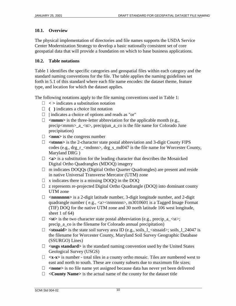
10.1. Overview
The physical implementation of directories and file names supports the USDA ServiceCenter Modernization Strategy to develop a basic nationally consistent set of coregeospatial data that will provide a foundation on which to base business applications.
10.2. Table notations
Table 1 identifies the specific categories and geospatial files within each category and thestandard naming conventions for the file. The table applies the naming guidelines setforth in 5.1 of this standard where each file name encodes: the dataset theme, featuretype, and location for which the dataset applies.
The following notations apply to the file naming conventions used in Table 1: < > indicates a substitution notation ( ) indicates a choice list notation | indicates a choice of options and reads as "or" <mmm> is the three-letter abbreviation for the applicable month (e.g.,
precip<mmm>_a_<st>, precipjun_a_co is the file name for Colorado Juneprecipitation)
<nnn> is the congress number <stnnn> is the 2-character state postal abbreviation and 3-digit County FIPS
codes (e.g., drg_r_<mdnnn>, drg_s_md047 is the file name for Worcester County,Maryland DRG )
<a> is a substitution for the leading character that describes the MosaickedDigital Ortho Quadrangles (MDOQ) imagery
m indicates DOQQs (Digitial Ortho Quarter Quadrangles) are present and residein native Universal Transverse Mercator (UTM) zone
x indicates there is a missing DOQQ in the DOQ z represents re-projected Digital Ortho Quadrangle (DOQ) into dominant county
UTM zone <nnnnnnn> is a 2-digit latitude number, 3-digit longitude number, and 2-digit
quadrangle number ( e.g., <a><nnnnnnn>, m3010601 is a Tagged Image Format(TIF) DOQ for the native UTM zone and 30 north latitude 106 west longitude,sheet 1 of 64)
<st> is the two character state postal abbreviation (e.g., precip_a_<st>;precip_a_co is the filename for Colorado annual precipitation)
<stssaid> is the state soil survey area ID (e.g., soils_l_<stssaid>; soils_l_24047 isthe filename for Worcester County, Maryland Soil Survey Geographic Database(SSURGO) Lines)
<usgs standard> is the standard naming convention used by the United StatesGeological Survey (USGS)
<x-x> is number - total tiles in a county ortho mosaic. Tiles are numbered west toeast and north to south. These are county subsets due to maximum file sizes;
<none> is no file name yet assigned because data has never yet been delivered <County Name> is the actual name of the county for the dataset title
JANUARY 25, 2001 DRAFT STANDARD FOR GEOSPATIAL DATASET FILE NAMING
SCMI Std 004-02 11
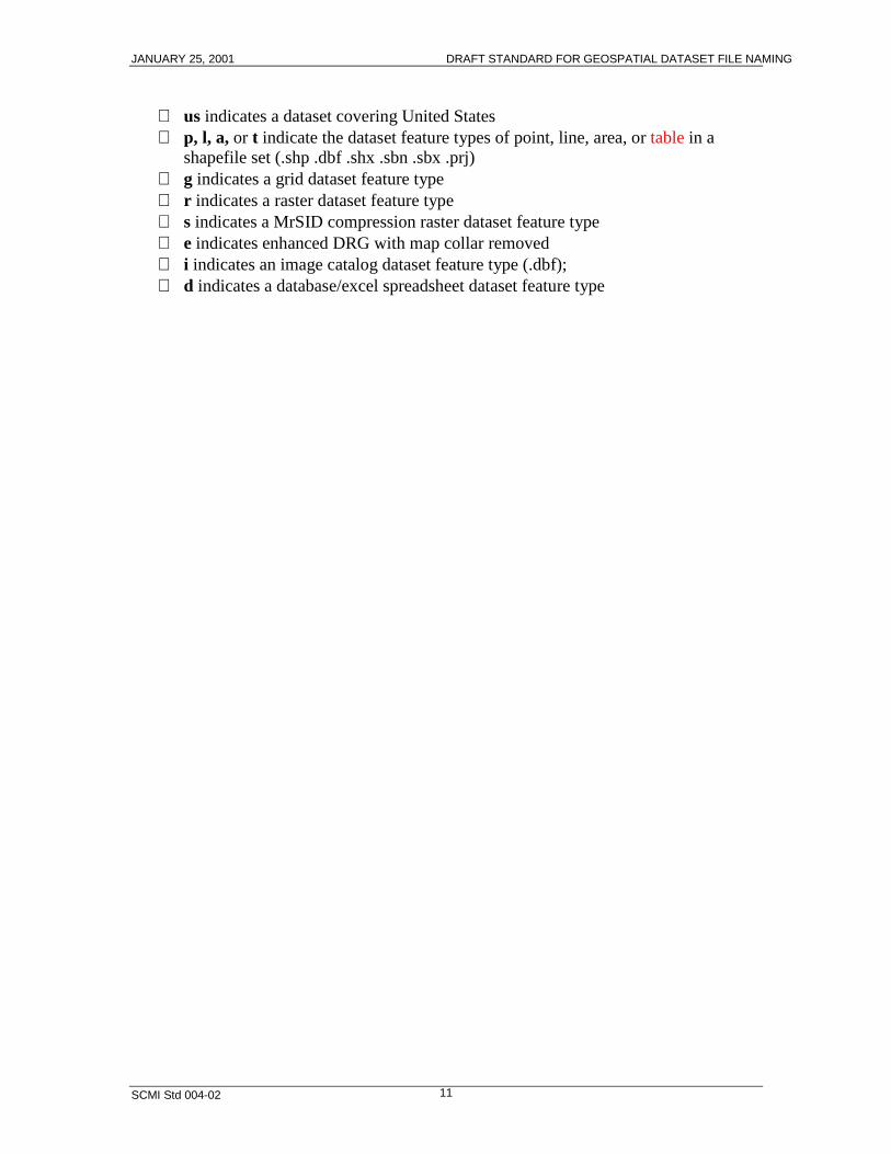
us indicates a dataset covering United States p, l, a, or t indicate the dataset feature types of point, line, area, or table in a
shapefile set (.shp .dbf .shx .sbn .sbx .prj) g indicates a grid dataset feature type r indicates a raster dataset feature type s indicates a MrSID compression raster dataset feature type e indicates enhanced DRG with map collar removed i indicates an image catalog dataset feature type (.dbf); d indicates a database/excel spreadsheet dataset feature type
JANUARY 25, 2001 DRAFT STANDARD FOR GEOSPATIAL DATASET FILE NAMING
SCMI Std 004-02 12
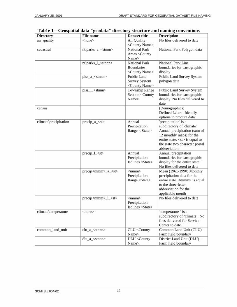
Tab1e 1—Geospatial data "geodata" directory structure and naming conventionsDirectory File name Dataset title Descriptionair_quality <none> Air Quality
<County Name>No files delivered to date
cadastral ntlparks_a_<stnnn> National ParkAreas <CountyName>
National Park Polygon data
ntlparks_l_<stnnn> National ParkBoundaries<County Name>
National Park Lineboundaries for cartographicdisplay
plss_a_<stnnn> Public LandSurvey System<County Name>
Public Land Survey Systempolygon data
plss_l_<stnnn> Township RangeSection <CountyName>
Public Land Survey Systemboundaries for cartographicdisplay. No files delivered todate
census (Demographics)Defined Later – Identifyoptions to procure data
climate\precipitation precip_a_<st> AnnualPrecipitationRange < State>
'precipitation' is asubdirectory of 'climate'.Annual precipitation (sum of12 monthly maps) for theentire state. <st> is equal tothe state two character postalabbreviation
precip_l_<st> AnnualPrecipitationIsolines <State>
Annual precipitationboundaries for cartographicdisplay for the entire state.No files delivered to date
precip<mmm>_a_<st> <mmm>PrecipitationRange <State>
Mean (1961-1990) Monthlyprecipitation data for theentire state. <mmm> is equalto the three-letterabbreviation for theapplicable month
precip<mmm>_l_<st> <mmm>PrecipitationIsolines <State>
No files delivered to date
climate\temperature <none> ‘temperature ‘ is asubdirectory of ‘climate’. Nofiles delivered for ServiceCenter to date.
common_land_unit clu_a_<stnnn> CLU <CountyName>
Common Land Unit (CLU) –Farm field boundary
dlu_a_<stnnn> DLU <CountyName>
District Land Unit (DLU) –Farm field boundary
JANUARY 25, 2001 DRAFT STANDARD FOR GEOSPATIAL DATASET FILE NAMING
SCMI Std 004-02 13
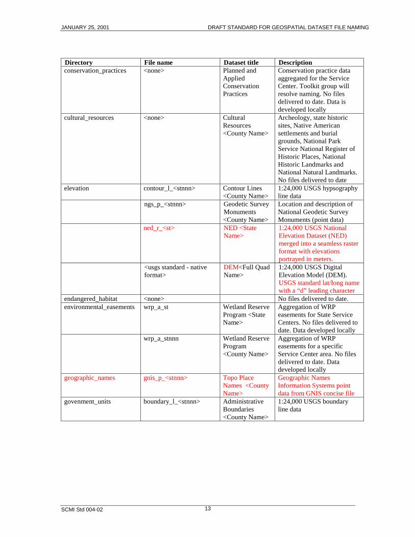
Directory File name Dataset title Descriptionconservation_practices <none> Planned and
AppliedConservationPractices
Conservation practice dataaggregated for the ServiceCenter. Toolkit group willresolve naming. No filesdelivered to date. Data isdeveloped locally
cultural_resources <none> CulturalResources<County Name>
Archeology, state historicsites, Native Americansettlements and burialgrounds, National ParkService National Register ofHistoric Places, NationalHistoric Landmarks andNational Natural Landmarks.No files delivered to date
elevation contour_l_<stnnn> Contour Lines<County Name>
1:24,000 USGS hypsographyline data
ngs_p_<stnnn> Geodetic SurveyMonuments<County Name>
Location and description ofNational Geodetic SurveyMonuments (point data)
ned_r_<st> NED <StateName>
1:24,000 USGS NationalElevation Dataset (NED)merged into a seamless rasterformat with elevationsportrayed in meters.
<usgs standard - nativeformat>
DEM<Full QuadName>
1:24,000 USGS DigitalElevation Model (DEM).USGS standard lat/long namewith a “d” leading character
endangered_habitat <none> No files delivered to date.environmental_easements wrp_a_st Wetland Reserve
Program <StateName>
Aggregation of WRPeasements for State ServiceCenters. No files delivered todate. Data developed locally
wrp_a_stnnn Wetland ReserveProgram<County Name>
Aggregation of WRPeasements for a specificService Center area. No filesdelivered to date. Datadeveloped locally
geographic_names gnis_p_<stnnn> Topo PlaceNames <CountyName>
Geographic NamesInformation Systems pointdata from GNIS concise file
govenment_units boundary_l_<stnnn> AdministrativeBoundaries<County Name>
1:24,000 USGS boundaryline data
JANUARY 25, 2001 DRAFT STANDARD FOR GEOSPATIAL DATASET FILE NAMING
SCMI Std 004-02 14
Directory File name Dataset title Descriptionboundary_a_<stnnn> Administrative
Areas <CountyName>
1:24,000 USGS boundarypolygon data (state park,wildlife refuge, etc.)
congdist_<nnn>_a_st CongressionalDistrict <nnn>
Full US Congressionaldistricts 104 – 106. <nnn> isthe congress number
cities_p_<stnnn> Cities <CountyName>
Cities point data fromGeographic NamesInformation System (GNIS)populated places file
cnty24K_a_<stnnn> CountyBoundary<County Name>
1:24,000 county boundarypolygon data
cnty24K _l_<stnnn> County Line<County Name>
1:24,000 county boundariesfor cartographic display
. cnty100k_a_<stnnn> CountyBoundary<County Name>
1:100,000 county boundarypolygon data from CensusTiger data.
cnty100k_l_<stnnn> County Line<County Name>
1:100,000 county boundaryfor cartographic display fromCensus Tiger data.
manfetr_a_<stnnn> Man Made AreaFeatures<County Name>
1:24,000 USGS manmadefeature polygon
manfetr_l_<stnnn> Man Made LineFeatures<County Name>
1:24,000 USGS manmadefeature line data
rcd_a_us ResourceConservation &DevelopmentAreas
Full US ResourceConservation & DevelopmentAreas polygon data
state_a_us State Areas Full US state polygonsstate_l_us State Boundaries Full US state boundaries for
cartographic displayswcd _a_st Soil and Water
ConservationDistrict
Full US Soil and WaterConservation Districtpolygon data
zip_p_us Zip Codes Full US zip code centroids(points). GIS ImplementationTeam to identify data source
hydrography damsites_p_<stnnn> NationalInventory ofDams<County Name>
National Inventory of Damspoint data
femaq3_a_<stnnn> Flood HazardMaps (FEMA)<County Name>
Federal EmergencyManagement Agency(FEMA) polygon data
hydro_dmf_l_<stnnn> Rivers andStreams (DMF)<County Name>
1:24,000 Soil Survey DigitalMap Finishing (DMF) linedata
hydro_l_<stnnn> Rivers andStreams <CountyName>
1:24,000 USGS line data

JANUARY 25, 2001 DRAFT STANDARD FOR GEOSPATIAL DATASET FILE NAMING
SCMI Std 004-02 15
Directory File name Dataset title Descriptionhydro_rf_l_<stnnn> Rivers and
Streams (EPAReach 3)<County Name>
1:100,000 EnvironmentalProtection Agency (EPA)Reach File line data
ntlhydro_l_<stnnn> Rivers andStreams <CountyName>
1:100,000 USGS/EPANational HydrographyDataset line data
hydrologic_units huc24K_a_<stnnn> Hydrologic Units<County Name>
1:24,000 polygon data of theHydrologic Units at the 5th
and 6th level.imagery <none> Other imagery files such as
satellite or non-standardimagery. No files delivered todate
land_use_land_cover lulc_a_<stnnn> Land Use LandCover <CountyName>
Polygon data of the Land UseLand Cover
nonveg_a_<stnnn> Barren Land(Topo Map)<County Name>
1:24,000 USGS non-vegetative polygon data (sandarea, beach, gravel beach,etc.)
nlcd_r_<st> Land Use LandCover <StateName>
30 meter USGS/EPANational Land Cover Datasetraster data.
surfcvr_a_<stnnn> Surface Cover(Topo Map)<County Name>
1:24,000 USGS surface coverpolygon data (woods, brush,orchard, etc.)
map_indexes napp_p_<stnnn> Photo Index(NAPP) <CountyName>
National Aerial PhotographyProgram (NAPP) point data
quads12k_a_<stnnn> QuarterquadAreas <CountyName>
1:12,000 quad polygon data
quads12k_l_<stnnn> QuarterquadLines <CountyName>
1:12,000 quad boundaries forcartographic display. No filesdelivered to date
quads24k_a_<stnnn> QuadrangleAreas <County Name>
1:24,000 quad polygons
quads24k_l_<stnnn> QuadrangleLines <CountyName>
1:24,000 quad boundaries forcartographic display. No filesdelivered to date
ortho_imagery mosaic<x-x>_s_<stnnn> County ortho<County Name>
APFO MrSID county orthomosaic of MDOQ. <x-x>number-total titles.
ortho_i_<stnnn> Ortho ImageCatalog <CountyName>
Ortho image catalog inDbaseIV format for TIFDOQs

JANUARY 25, 2001 DRAFT STANDARD FOR GEOSPATIAL DATASET FILE NAMING
SCMI Std 004-02 16
Directory File name Dataset title Description<a><nnnnnnn> MDOQ <Full
Quad Name>TIF DOQ <a><nnnnnnn> isleading character, two spacesfor latitude, three spaces forlongitude and two spaces forthe 01 to 64 quadranglenumbers in the one degreeblock.Leading character can equal:m – all DOQQs present andreside in native UTM zonex – there is a missing DOQQin the DOQz – re-projected DOQ intodominant county UTM zone
<usgs standard> DOQQ<QuarterquadName>
USGS Quarterquads – Anyformat (.bil, .bsq, .bip, .tif).Text name of quarter quadswith “_” for imbeddedspaces.
mosaic_s_<stnnn> County ortho<County Name>
NCGC MrSID county orthomosaic
plants <none> No files delivered to datesoils crpdata_d_<stssaid> 1990 CRP
Frozen Soil ListNOT A MAP-Excelspreadsheet with 1990 frozensoils data used forConservation ReserveProgram (CRP) eligibilitydeterminations
soilattributes_d_<stssaid> <Soil SurveyArea Name> SoilAttributes
NOT A MAP-Access database of National SoilInformation System (NASIS)distribution format 1.0
mlra_a_us Major LandResource Areas
Full US Polygon data ofMajor Land Resource Areas(MLRA) Reselected to SCArea
soil_a_<stssaid> SSURGO Areas<Survey AreaName>
SSURGO Soils Polygon data
soil_l_<stssaid> SSURGO Lines<Survey AreaName>
Outlines of the SSURGOpolygon boundaries forcartographic display
soil_p_<stssaid> SSURGO Points<Survey AreaName>
Point data of the soils specialfeatures
soillfetr_l_<stssaid> SSURGO LinearFeatures<Survey AreaName>
Line data of the soils specialfeatures
JANUARY 25, 2001 DRAFT STANDARD FOR GEOSPATIAL DATASET FILE NAMING
SCMI Std 004-02 17
Directory File name Dataset title Descriptionssa_a_<stssaid> SSA Boundary
<Soil SurveyName>
Polygon data limit of SoilSurvey Area (SSA)
topographic_images drg_i_<stnnn> Topo ImageCatalog <CountyName>
TIF Digital Raster Graphindex of enhanced DRG
drg_s_<stnnn> Topo <CountyName>
MrSID Digital Raster Graphswithout map collar
<usgs standard> <Full QuadName> - Topo
USGS DRG Quad with collar
<usgs standard>_e <Full QuadName> -Enhanced Topo
Enhanced DRG image withmap collar removed
transportation misctrans_l_<stnnn> Utility lines(Topo Map)<County Name>
1:24,000 USGS line data(power transmission lines,substation, pipelines, etc.)
railroads_l_<stnnn> Railroads (TopoMap) <CountyName>
1:24,000 USGS line data-railroad layer
railroads_dmf_l_<stnnn> Railroads (DMF)<County Name>
1:24,000 Soil Survey (DigitalMap Finishing) railroad linedata
roads_l_<stnnn> Roads (TopoMap) <CountyName>
1:24,000 USGS line data-Roads layer
roads_dmf_l_<stnnn> Roads (DMF)<County Name>
1:24,000 Soil Survey (DigitalMap Finishing) roads linedata
wetlands nwi_a_<stnnn> NWI (FWS)<County Name>
Polygon data of the NationalWetland Inventory (NWI)Fish and Wildlife Service(FWS)
nwilfetr_l_<stnnn> NWI LinearFeatures (FWS)<County Name>
Linear Features line data ofthe NWI
nwi_l_<stnnn> NWI Lines(FWS) <CountyName>
Outlines of the NWI polygondata for cartographic display
nwi_p_<stnnn> NWI Points(FWS) <CountyName>
Point data of the NW I
JANUARY 25, 2001 DRAFT STANDARD FOR GEOSPATIAL DATASET FILE NAMING
SCMI Std 004-02 18
Appendix A − Bibliography
When the following standards are superseded by an approved revision, the revision shallapply.
[A1] Geospatial Data Acquisition, Integration, and Delivery National ImplementationStrategy Plan, Draft #4 Service Center Business Process Reengineering Data AIDTeam, September 22, 1999
[A2] SCMI Std 003, Standard for Geospatial Data Set Metadata
[A3] SCMI Std 005, Standard for Geospatial Feature Metadata [This standard iscurrently under development.]
[A4] SCMI Std 007, Standard for Geospatial Data
[A5] USDA Service Center Geographic Information System (GIS) Strategy,Interagency Team, August 18, 1998
[A6] USDA Service Center Initiative Directory Structure and File Naming ConventionChange Control Policy, Initial Draft, IO Lab, October 8, 1999
JANUARY 25, 2001 DRAFT STANDARD FOR GEOSPATIAL DATASET FILE NAMING
SCMI Std 004-02 19
Appendix B − Business Process Reengineering directory structure
Prior to the development of this standard, the initial directory structures (referred to asversion 5) for the geospatial dataset collection fielded at the Business ProcessReengineering (BPR) sites reflected the storage structure at the data warehouse thatsupplied the data. In order to maintain all county based geospatial datasets in a singlewarehouse separated according to Service Center, the directory structure was defined as:
<disk drive>: Service Center Themes
OIP number and Service Center Name State and County FIPS with County Name
<geospatial dataset category (directory/folder) <geospatial dataset category (directory/folder) <geospatial dataset> <geospatial dataset>
Figure B.1—Initial directory structure
This structure organizes datasets within a generic Service Center Themes folderaccording to a unique Service Center Office Information Profile (OIP) number andsecond according to county. Each county serviced within a Service Center possesses itsown uniquely identified folder (directory) and is named according to the five-digitFederal Information Processing Standard (FIPS) code and county name. For instance, theactual path to a roads map on NT would be:
C:\Service Center Themes\2487 Sacramento\06067 Sacramento\Transportation\roads.shp
Personnel at the BPR sites using the desktop GIS, ArcView in its native mode to accessgeospatial datasets, found the length and depth of this directory structure too cumbersomefor accessing geospatial datasets. For example, Service Centers that service only onecounty still had to navigate through the county level directory (<State and County FIPSwith County Name>) to access dataset categories where only one county's worth of dataexisted. Similarly, the Service Center level of the directory structure (<OIP Number andService Center Name>) had to be negotiated even though there would only ever be oneoccurrence at this level. As a result of this learning experience at the BPR pilot sites andexperiences developing applications that have to traverse this directory structure, thedirectory structure was flattened and streamlined to facilitate access to the datasets withfewer steps.