Embed Size (px)
Citation preview

November 2019
Standard Restricted Access Vehicle (RAV) Route Assessment Guidelines

Standard Restricted Access Vehicle Route Assessment Guidelines
Document No: D14#493277 Page 2 of 31
Contents DEFINITIONS ................................................................................................................................. 4 1 INTRODUCTION ................................................................................................................... 6 1.1 Purpose ................................................................................................................................. 6 1.2 Application ............................................................................................................................. 6 1.3 Assessment Requirements .................................................................................................... 7 1.4 Planning Evaluation ............................................................................................................... 8 1.5 Further Assistance ................................................................................................................. 8 2 ASSESSMENT CRITERIA .................................................................................................... 9 2.1 Traffic Data ............................................................................................................................ 9 2.2 Structures .............................................................................................................................. 9 2.3 Overhead Clearance ............................................................................................................ 10 2.4 Rural Road Widths ............................................................................................................... 10 2.5 Urban and Town Site Road Widths ...................................................................................... 13 2.6 Provision for Overtaking ....................................................................................................... 13 2.7 Steep Ascending Grades ..................................................................................................... 15 2.8 Turning at Intersections ....................................................................................................... 16 2.9 Railway Level Crossings ...................................................................................................... 19 2.10 Off-road Parking .................................................................................................................. 21 2.11 Other Road Users ................................................................................................................ 22 2.12 Slowing and Stopping .......................................................................................................... 23 3 COMMUNITY CONSIDERATIONS ...................................................................................... 23 3.1 Noise ................................................................................................................................... 23 3.2 Vibration .............................................................................................................................. 24 3.3 Dust and dirt ........................................................................................................................ 24 3.4 Community Consultation ...................................................................................................... 24 3.5 Alternative Transport Modes ................................................................................................ 24 4 APPENDICES ..................................................................................................................... 25
Appendix A: Rural Road Minimum Width ............................................................................. 26 Appendix B: Low Volume Rural Road Minimum Widths ....................................................... 27 Appendix C: Town Site Road Minimum Widths .................................................................... 28 Appendix D: Required Sight Distances ................................................................................ 29 Appendix E: Operating Conditions ....................................................................................... 30 Appendix F: RAV Access Assessment Process ................................................................... 31

Standard Restricted Access Vehicle Route Assessment Guidelines
Document No: D14#493277 Page 3 of 31
Document Control Owner Main Roads Heavy Vehicle Services
Custodian Access Manager
Document Number D14#493277
Issue Date July 2014
Review Frequency Annually
Amendments Revision Number
Revision Date Description of Key Changes Clause /
Page No.
1 May 2016
Removed Appendix G ‘Turning Radii’ Removed Appendix K ‘Assessment Form Template’ Updated Appendix H ‘Low Volume Condition 7’ Updated Appendix D to include the wording ‘with dedicated cycle lane’ Updated contact details
Appendices & 1.5
2 July 2016
Updated to include revised minimum road widths for RAV Categories 2-7 and 9-10 & moved Type B traffic volume / road length table Added Type B traffic volume / road length table
Appendix C and 2.4.4
3 October 2016
Amended list of standard turning templates Updated web location for turning templates Amended low volume condition 1
Appendix G & H, 2.92
4 March 2017 Remove section 2.9.5
5 April 2017 Updated Main Roads website details 1.4
6 May 2017 Amended low volume condition 6 Appendix H
7 July 2017 Note added relating to private driveways 1.2
8 December 2017
Amended stopping sight distances Amended entering sight distances Amended wording relating to road parking Amended wording to include load/vehicle height being 4.6m
Appendix E, F, D, 2.3
9 August 2018
Amended wording relating to provision for overtaking Amended wording relating to turning at intersections Amended wording and requirements for railway level crossing Amended wording relating to off-road parking Amended appendices Appendix E, G (Templates) & I removed Added Figure 1 to 8 Incorporated concessional assessment requirements Amended section 2.4.1 Signage, 2.8.1 Acceleration Lanes, 2.9.1 Signage & 2.9.4 Rail Crossings
2.6, 2.9, 2.10, 2.11, Appendix A, B, C, D, E 1.1, 2.21

Standard Restricted Access Vehicle Route Assessment Guidelines
Document No: D14#493277 Page 4 of 31
10 September 2018
Amended wording relating to turning at intersections Amended wording relating to provision of overtaking and removed Figure 1. Amended wording relating to Approach Sight Distance and Entering Sight Distance
2.6, 2.8, 2.84, 2.85
11 November 2019 Amended introduction to clarify the intent of the guidelines. Page 6.
DEFINITIONS The following are definitions for terms used in these Guidelines. Refer to the definitions in the Road Traffic (Vehicles) Act 2012 and any subsidiary legislation to this Act for the meanings of any terms not defined in this section.
Term Definition
AADT Annual Average Daily Traffic (AADT) the daily number of vehicles travelling on a road, averaged over one year. It is determined by the total yearly two-way traffic volume divided by 365, expressed as vehicles per day.
Approach Sight Distance (ASD)
The distance required for a driver of a RAV, travelling at a given speed, to observe the approaching intersection, and react or stop if necessary.
Bridge A structure (with the exception of gantries) having a clear opening in any span of greater than 3 metres measured between the faces of piers and/or abutments or structures of a lesser span with a deck supported on timber stringers.
Carriageway Width
That portion of a road or structure devoted particularly to the use of vehicles that is between guide posts, kerbs or barriers where these are provided, inclusive of shoulders and auxiliary lanes.
Culvert A structure under a road having only clear openings of less than or equal to 3 metres measured between the faces of piers and/or abutments or a pipe shaped structure of any diameter.
Entering Sight Distance (ESD)
The required sight distance for a RAV driver to see a sufficient gap in oncoming traffic that will allow a RAV, with greater length and lower acceleration capacity, to clear the intersection safely.
HVS Main Roads Heavy Vehicle Services. Main Roads website www.mainroads.wa.gov.au
Passenger Car Equivalence
Passenger Car Equivalence (PCE) factors are a relative measure of the traffic flow impedance effects of different vehicle types. The PCE factor for a particular vehicle type is the equivalent number of passenger cars (AUSTROADS Vehicle Class 1) that would have the same impedance effect as a single vehicle of that type.
Order An Order issued under the Road Traffic (Vehicles) Act 2012.
RAV Restricted Access Vehicles (RAV) consists of all combinations of vehicles exceeding 19 metres in length or 42.5 tonnes gross mass including B-Doubles, road trains and truck-and-trailer combinations.
Remote Road A general term for a main arterial road carrying mostly long distance traffic.

Standard Restricted Access Vehicle Route Assessment Guidelines
Document No: D14#493277 Page 5 of 31
Term Definition
Rural Road All roads that provide a secondary network of National, State and local government roads connecting cities and towns.
Seal Width Width between edges of sealed surface or between edge lines (where installed on undivided carriageways), whichever is less.
Structure A bridge or culvert. TPA Tonnes per annum.
Urban and Town Site Road
All roads within a populated area of established dwellings, a central place of trade and recognised as a distinct place. Generally the area will act as a central hub of activity for the community.
VPD
Vehicles Per Day (VPD) is the number of vehicles observed passing a point on a road in both directions for 24 hours. It is a measure of daily traffic volume, often more relevant to low volume, local government roads, typically rural roads in these guidelines. VPD can differ from AADT in being a better measure of traffic volume during periods of more intensive RAV usage or seasonal tourist traffic.
Vehicle Regulations The Road Traffic (Vehicles) Regulations 2014.
Related Documents Document # Title
D16#198414 Guidelines for Approving RAV Access
D16#374056 Tri Drive Route Assessment Guidelines
NA RAV Route Assessment Form

Standard Restricted Access Vehicle Route Assessment Guidelines
Document No: D14#493277 Page 6 of 31
1 INTRODUCTION 1.1 Purpose These guidelines have been prepared to provide guidance to a person conducting an onsite assessment, on an existing road, for the purpose of assisting Main Roads Heavy Vehicle Services (HVS) in making an informed decision as to whether or not a road is suitable for use by a particular category of Restricted Access Vehicle (RAV). These guidelines are to be read in conjunction with the following documents, available on the Road Access page on the Main Roads website:
- Framework for Adding Roads on the RAV Networks; - Framework for Downgrading Local Roads on the RAV Networks; - Framework for Using Consultants to Assess Local Government Roads for Inclusion on the
RAV Network; and - Guidelines for Approving RAV Access.
The RAV Route Assessment Form is also available on the Main Roads website to further assist in ensuring the required information is captured during the onsite assessment. These RAV Route Assessment Guidelines form part of the overall RAV access assessment process, as outlined in Appendix F, to enable HVS to make an informed decision on behalf of the Commissioner of Main Roads, in accordance with the Commissioner’s authority to approve RAV access under provisions of the Road Traffic (Vehicles) Act 2012. These guidelines are not road design standards. However, if a road is constructed to the appropriate road design standards and approved by Main Roads, the road will pass the RAV access assessment process. 1.2 Application For the purpose of these guidelines, “standard” RAVs are those vehicle combinations specified as Category 1 to 10 vehicle combinations under the Prime Mover, Trailers Combinations Order 2017 and Truck, Trailer Combinations Order 2017. The standard RAV Categories have been grouped into four (4) assessment levels, as follows:
• Level 1 - RAVs Categories 2-4 (e.g. pocket road train, B-Double, and other RAVs with a maximum length of either 25.0 m or 27.5 m);
• Level 2 - RAVs Categories 5-6 (e.g. RAVs with a maximum length of 36.5 m and a maximum mass of 87.5T);
• Level 3 - RAVs Categories 7-8 (e.g. RAVs with a maximum length of 36.5 m and a maximum mass of 107.5T); and
• Level 4 - RAVs Categories 9-10 (e.g. RAVs with a maximum length of 53.5 m).
Note 1: A road approved for one of the base RAV networks listed above, means the road is also approved and added to AMMS level one (1) for the equivalent network. Note 2: Where a RAV assessment is for operations under a concessional loading scheme such as the Accredited Mass Management Scheme (AMMS), the assessor must take into account the additional mass when requesting a structures assessment as per Section 2.2.

Standard Restricted Access Vehicle Route Assessment Guidelines
Document No: D14#493277 Page 7 of 31
Where quantitative limits are recommended, they are intended as a guide only and are no substitute for common sense and judgement based on experience. In certain cases, routes which do not meet the requirements outlined in this document can be accepted as RAV routes by imposing additional conditions, such as speed restrictions, curfew etc. Refer to the Guidelines for Approving RAV Access. 1.3 Assessment Requirements Route assessments will only be accepted from a suitably qualified person, approved by Main Roads. The assessor should have experience and knowledge of the following:
• The principles of heavy vehicle operation, including vehicle configurations, maximum dimensions and axle load limits;
• Heavy vehicle dynamic performance characteristics, including limitations on the ability of heavy vehicles to accelerate, brake, ascend grades and negotiate corners;
• Heavy transport issues, legal requirements and permit systems; and
• Road safety concepts and principles. When considering a potential route, the assessor is advised to initially perform a desktop assessment using all available information. In some cases this initial assessment will identify particular physical constraints, such as posted bridge load limits and road width deficiencies, which may render the route unacceptable without the need for further assessment. If the applicant is willing to pursue upgrades to the road, then a full assessment is required to identify all deficiencies. This is to alleviate any problems with some upgrades being carried out and then the full assessment conducted only to identify additional deficiencies. The assessment will only identify the deficiencies and will not provide upgrade design requirements. Heavy vehicle use on a particular route may have some negative impacts on the environment, community and traffic. Assessors must first determine if the proposed route is the most appropriate route for the particular operations and recommend variations to the initially proposed route to reduce such impacts. As part of any route assessment for a Restricted Access Vehicle (RAV), HVS does not assess any access for driveways adjoining a RAV network road. It remains the responsibility of the property owner to ensure safe ingress and egress to the property. Before making a decision on an application for route access, Main Roads may deem it necessary to do any or all of the following:
• Perform a further assessment of the route;
• Assess the suitability of the road pavement;
• Assess the suitability of all structures on the proposed route to accommodate the specific vehicle;
• Specify conditions of access such as speed limits, hours of operation or accreditation requirements;
• Obtain local government agreement for the proposed route (for all operators);
• Recommend a number of road improvements as conditions of approval; and
• PBS assessment to assess vehicle performance.
To ensure network continuity, when assessing a road, all connection points to existing RAV networks must be assessed for suitability and a holistic approach should be taken to ensure overall network connectivity in the area.
Standard Restricted Access Vehicle Route Assessment Guidelines
Document No: D14#493277 Page 8 of 31
1.4 Planning Evaluation Assessment of a proposed route should be checked against any future planning proposals to evaluate the potential impact of RAVs. The relevant Local Government and Regions should be consulted as part of the process. 1.5 Further Assistance Additional information and guidance is available from HVS via telephone 138 486 or [email protected]

Standard Restricted Access Vehicle Route Assessment Guidelines
Document No: D14#493277 Page 9 of 31
2 ASSESSMENT CRITERIA 2.1 Traffic Data 2.1.1 Traffic Counts In order to determine the suitability of a road for RAV access, it is essential to obtain current traffic counts for the particular road. The traffic counts must be considered when determining appropriate road widths, potential congestion issues and relevant operating conditions. 2.1.2 Accident Statistics
Appropriate research must be conducted prior to progressing with a route assessment to establish if there is an accident history on the particular road that may be exacerbated by the introduction of RAVs on the road. Safety is the primary factor for consideration. If crash history data is available, it may be useful to investigate whether certain times of the day cause particular risks, while at other times the risk is significantly lower. In these cases, it may be warranted to recommend that the RAV only use the route during low-risk hours.
2.2 Structures 2.2.1 Load Capacity All bridges and load restrictive culverts on the requested route will be assessed for the relevant level of RAV Network access by Main Roads Structures Engineering Branch, via HVS. When carrying out an assessment for Network 2, ensure a separate Structures Engineering assessment is carried out for the Short B Triple combination. Any bridge restrictions for the Short B triple combination must be listed in the Operating Conditions in the relevant vehicle category section and a notation included in the conditions for the relevant road. Consultation with local governments is required to ensure all culverts on local government roads have been appropriately considered. 2.2.2 Structure Width Requirements Table 1: Minimum Width between Kerbs/Carriageway on a Structure
*Conditions apply; refer to 2.4.2 and Appendix B; **RAV ASD should be measured from a truck driver’s eye height of 2.4 m. Minimum requirements for ASD refer to Appendix D.
AADT Minimum Width
Between Kerbs/carriageway (m)
Quality of Approaches
Less than 75 3.5* Structures with adequate Approach Sight Distance (ASD)**.
75 to 150 5.3 Structures with adequate ASD, clearly signed and road
clearly marked.
7.0 Structures that have inadequate ASD, inadequate signage or no road markings.
150 to 500 5.8 Structures with adequate ASD, clearly signed and road
clearly marked.
7.2 Structures that have inadequate ASD, inadequate signage or no road markings.
More than 500 7.2 All structures at this traffic volume

Standard Restricted Access Vehicle Route Assessment Guidelines
Document No: D14#493277 Page 10 of 31
2.3 Overhead Clearance Although applicable for all vehicles, RAVs with high loads are particularly vulnerable to striking low overhead obstructions. Route assessments must confirm that adequate overhead clearances are available to safely accommodate a load/vehicle height of 4.6m, as follows:
• Overhead obstructions (except power lines) - 300 mm clearance; and
• Power lines - at least the minimum clearance required by telecommunications and electrical transmission cable providers.
Where telecommunications and/or electrical transmission cables cross the route, approval for a load/vehicle height of 4.6m must be obtained from the relevant controller/s listed in the “Contact Details for Other Agency Approvals” located on the Oversize Over-mass Permits page of the Main Roads website. Where the required load/vehicle height of 4.6m is not approved by the cable provider, the cable provider must specify the maximum approved load/vehicle height and the location of the restricting power line. RAV access may still be considered with appropriate height conditions. 2.4 Rural Road Widths When the hauling unit of a RAV travels along a straight path over an uneven surface, the trailing units do not necessarily follow along the same path as the lead unit. This is defined as “off-tracking” and depends on several factors, including:
• The steering actions of the driver;
• Vehicle configuration and coupling arrangements between units;
• Misalignment of the axles;
• Suspension (geometry, bump and roll steer effects) and tyre characteristics;
• Vehicle length;
• External disturbances that include road roughness, cross-slope and side loading from wind-gusts; and
• Speed of travel.
The maximum deviation in tracking over a straight section of road, when added to the width of the RAV, is termed the ‘swept width’. To safely accommodate the swept width of RAVs, adequate road width must be provided. To assess the widths of rural roads, tables of minimum carriageway widths and sealed widths to accommodate the swept width are listed at Appendix A. To be suitable for RAV access, a road should be sealed if AADT is over 150 and annual freight tonnage is over 300,000 tonnes per annum. The requirement for the road to be sealed is partly for safety reasons, but more so for road sustainability. In the absence of any traffic data, the following parameters may enable a judgement as to whether a road needs to be sealed:
• If the road is unlikely to be used by more than 10 RAVs per day; or
• If the road is unlikely to be used by more than 60 RAVs per day over a seasonal two month period.
Standard Restricted Access Vehicle Route Assessment Guidelines
Document No: D14#493277 Page 11 of 31
When considering whether a road has adequate width, an assessment should also be made in relation to any potential risks posed by:
• Crests;
• Pronounced cambers;
• Poor shoulder condition;
• Surface roughness; and
• Reduced sight distances.
Despite a road’s width being above the specified minimum in Appendix A, these factors may require additional width, application of additional RAV operating conditions, or in extreme cases, mean the route is unsuitable for RAV access. Minor width deficiencies are acceptable, particularly if it is only for a small portion of the road. If width requirements are relaxed, a risk assessment should be undertaken to consider other factors to ensure safe operation. Off-tracking of a vehicle combination is more severe at high speeds; therefore minimum seal width may be reduced where speeds are controlled to 60 or 70 km/h. Minimum seal widths may also be reduced on roads where all other users are familiar with the operator of multi combination vehicles, e.g. farm access roads and mine access roads. 2.4.1 Sight Distance Considerations at Curves and Tight Bends When the hauling unit of a RAV travels around a curve or tight bend, the trailing units may take up considerable additional road with. This is defined as “swept width” and depends on several factors, including:
• Radius of the curve or tight bend;
• Length of vehicle combination;
• Number and type of articulation points; and
• Road surface and geometry. In instances where it is identified the RAV would be required to utilise additional road width and potentially encroach onto the opposite side of the road, the assessor must ensure on approach to the curve or tight bend, there is sufficient visibility to observe oncoming vehicles, and react or stop if necessary. The table in Appendix D shows the required sight distance for RAVs, given the speed and the gradient of the road. It will be necessary for the assessor to conduct swept path assessments on curves to determine if the RAV is likes to encroach onto the opposite side of the road. Note: Access should be declined if the RAV crosses a solid white line. 2.4.2 Low Volume Road Width When assessing road width for Network 2 to 7 or 9 to 10 RAV access, where traffic volume is less than 75 vehicles per day, the width of the road may be assessed in accordance with the width requirement in Appendix B. Appendix E conditions must be applied. If the road width meets the requirements in Appendix A, the conditions as per Appendix E are not necessary.

Standard Restricted Access Vehicle Route Assessment Guidelines
Document No: D14#493277 Page 12 of 31
2.4.3 Traffic Volume Consideration It is important to use the most appropriate measure of traffic volume when applying Appendix A and Appendix B. For medium to high traffic roads, where AADT is more than 500, AADT will usually be a suitable measure of traffic volume. For low to medium traffic roads, where AADT is from 150 to 500, higher seasonal traffic volume may be a more appropriate measure of traffic volume. For these roads, the widths in Appendix A are the relevant guidelines. For low traffic volume roads, where AADT is less than 75, with higher seasonal variations, obtaining a best estimate of such higher daily volumes (VPD) is recommended. Appendix B only applies if AADT and any higher seasonal traffic volumes (VPD) are both less than 75. Otherwise, road width must be assessed using Appendix A. 2.4.4 Assessing a Road in Sections The road may be composed of a number of sections that vary in their standard and that would fall into different categories of RAV suitability, or require different operating conditions (e.g. for low volume roads). Width variation is a typical example of this principle. Where differing sections are reasonably long, it can be beneficial to separately assess each section as to its category of RAV access and any applicable operating conditions. Assessors should only consider applying this method of assessment where there is a likely benefit and a practical start and finish point. 2.4.5 Short Sections of Reduced Width There may be short narrow sections along the road due to narrow structures, roadside vegetation or short narrow sections of pavement. Provided narrow sections meet certain criteria, the minimum road width does not need to be considered the actual width of the entire road for assessment purposes. In the absence of any clearly identified other risk factors, clauses (a) and (b) below can be applied to assess the width deficiencies of narrow sections. (a) Traffic Volume Less than 75 Vehicles per Day This clause only applies to low volume rural roads that do not meet the width requirement in Appendix A, and for which the operating conditions in Appendix E will apply to RAVs. Where all narrow sections of the low volume rural road meet the following criteria, the minimum width of the road can be considered to be the width of the road, excluding the narrow sections, when assessing suitability in accordance with Appendix B:
• Narrow sections must not be less than 3.5 m wide;
• Each narrow section must not be more than 100 m long;
• A combination of narrow points that are all within a single 100 m length of road can be considered to be one single narrow section;
• Two adjacent narrow sections must not be within 150 m of each other;
• Continuous unbroken sight distance must extend from a point at least 150 m from each end of any narrow section through the narrow section to a point at least 150 m beyond the section, in both directions; and
• Combined length of narrow sections is no more than 10% of total road length. All narrow sections shorter than 50 m shall be considered to have an effective length of 50 m.
If any narrow section fails to meet the 3.5 m minimum width criteria, the route shall be considered unsuitable for RAV access. Where all narrow sections meet the 3.5 m minimum width criteria, but do not meet all the remaining criteria, the route shall be considered unsuitable for RAV access on a two-way RAV traffic basis. However, the route may still be suitable for one-way RAV traffic only, provided

Standard Restricted Access Vehicle Route Assessment Guidelines
Document No: D14#493277 Page 13 of 31
operating conditions as per Appendix B for a Type B road are applied. Type B roads suitability is also subject to traffic volume and road length requirements outlined in Table 2. Table 2: Maximum allowable road length for Type B suitability
Daily Traffic Volume 0 to15 VPD 16 to 30 VPD 31 to 50 VPD 51 to 75 VPD Max Road Length 5.0 km 2.0 km 1.5 km 1.0 km
(b) Traffic Volume from 75 to 500 Vehicles per Day This clause only applies to medium volume roads that generally meet the width requirements in Appendix A. Where all narrow sections of a medium volume road meet the following criteria, the minimum width of the road can be considered to be the width of the road, excluding the narrow sections, when assessing suitability in accordance with Appendix A:
• Narrow sections should not have carriageway width more than 1.3 m below Appendix A values;
• For sealed road, narrow sections should not have sealed width more than 0.2 m below Appendix A values;
• Each narrow section should not be more than 2 km long; and
• The combined length of narrow sections should not be more than 15% of total road length.
Similar principles may logically carry over to assessment of higher traffic volume roads; however the width deficiencies will need to be assessed on a case-by-case basis. 2.5 Urban and Town Site Road Widths There are a number of width requirements to be considered for RAVs travelling in urban and town site areas. As well as accommodating the additional swept width of RAVs, the width requirements for activities such as cycling and kerbside parking also need to be taken into account. The minimum road width requirements in town site areas are listed in Appendix C. 2.6 Provision for Overtaking RAVs tend to operate at lower average speeds than light vehicles. If the road does not have sufficient overtaking opportunities, drivers of light vehicles may experience delays behind slower moving RAVs and in some cases may form “queues” of vehicles waiting to overtake. This may cause driver frustration and thereby increase the risk of drivers attempting to overtake when it is not safe. Therefore it is essential, from a road safety perspective, to have adequate overtaking opportunities on a RAV route.
It is recommended that AADT figures are used to assess overtaking opportunities, however the assessor should consider the impact of seasonal traffic during the assessment, as the AADT could be less than seasonal peak traffic volume. The volume of traffic and percentage of RAVs on the route affects the requirement for overtaking opportunities. To assess suitability of overtaking, an AADT derived using the Passenger Car Equivalence (PCE) factors (Table 3) shall be used. The derived AADT is calculated by multiplying the AADT for each of the Austroads vehicle Class by the PCE factor based on the road’s terrain as per Table 3. This derived ADDT is the AADT figure to use in Table 4 below.

Standard Restricted Access Vehicle Route Assessment Guidelines
Document No: D14#493277 Page 14 of 31
An example of calculating the derived AADT is listed below:
Sum of AVG AADT PCE Flat Terrain AADT Flat Terrain Austroads 1 & 2 3,180 1 3,180 Austroads 3, 4 & 5 1,893 2 3,786 Austroads 6, 7 8 & 9 285 2.5 713 Austroads 10 (RAV 2 - 4) 120 4 480 Austroads 11 (RAV 5 - 8) 117 4 468 Austroads 12 (RAV 9 -10) 2 9 14
AADT derived 8,640 PCE factors represent the equivalent number of light vehicles for a particular type of RAV or general access heavy vehicle. The use of PCE factors provides a derived AADT value that can then be used to better assess overtaking opportunities. Table 3: Passenger Car Equivalence Factors for RAVs
Vehicle Types PCE Factors
on Flat Terrain PCE Factors
on Rolling Terrain
Austroads Class 1 1 1.3 Austroads Class 2 1 1.3
Austroads Class 3 to 5 2 3.5 Austroads Class 6 to 9 2.5 5
Austroads Class 10 RAVs Categories 2-4 4 10 Austroads Class 11 RAVs Categories 5-8 4 10 Austroads Class 12 RAVs Categories 9-10 9 22
The maximum distances between overtaking opportunities are shown in Table 4. In all cases, the assessment of steep ascending grades in Section 2.7.1 must be performed separately. Table 4: Maximum Distances between Overtaking Opportunities
AADT (Derived using PCE Factors)
Maximum AVERAGE distance between
overtaking opportunities
Maximum distance between any two
overtaking opportunities
Notes
500 or below N/A
N/A
Provision of additional opportunities is usually not justified.
501 to 1000 15 km 30 km
1001 to 1800 8 km 15 km
1801 and above 5 km 10 km
At AADT > 2700, additional opportunities that exceed the criteria may be necessary.
For each overtaking opportunity, the portion of road available to complete the overtaking opportunity should meet the minimum length shown in Table 5.

Standard Restricted Access Vehicle Route Assessment Guidelines
Document No: D14#493277 Page 15 of 31
Table 5: Minimum Length for Overtaking Opportunities
Road Section Operating
Speed (km/h)
Assumed Truck Speed
(km/h)
Length (m)
RAVs Categories 2-4
RAVs Categories 5-8
RAVs Categories 9-10
70 60 600 640 690 80 69 740 790 860 90 77 890 950 1040 100 86 1070 1130 1240 110 94 1290 1310 1440
Note: The above lengths are generally determined by measuring the length of the divided line where overtaking is permitted for the particular lane. 2.7 Steep Ascending Grades 2.7.1 RAVs Losing Speed on Grades The speed of RAVs ascending long and steep grades can be reduced to the extent that the speed differential is hazardous for vehicles approaching from behind. If possible, steep ascending grades should have overtaking lanes. In some cases where an overtaking lane is not provided, the drivers of faster following vehicles may become frustrated and attempt an overtaking manoeuvre when unsafe to do so. A RAV speed reduction to 40 km/h is considered the threshold point at which drivers will seek to overtake a slower vehicle, regardless of whether or not adequate sight distance is available. Table 6 outlines the maximum distance required for a laden RAV travelling up a grade to slow down to 40 km/h. For grades or consecutive combinations of varying grades exceeding these distances, it is recommended that the grade should have an additional climbing lane for RAVs to mitigate the risk of other road users overtaking without appropriate sight distances. Table 6: Maximum distances (m) of uphill travel before RAV speeds are reduced to 40 km/h
Grade %
RAVs Categories 2-6 RAVs Categories 7-8 RAVs Categories 9-10 80 km/h
Approach Speed
100 km/h Approach
Speed
80 km/h Approach
Speed
100 km/h Approach
Speed
80 km/h Approach
Speed
100 km/h Approach
Speed
3 * * * * 1080 1650
4 950 1410 900 1350 690 1110
5 640 980 610 960 520 840
6 480 760 470 750 410 680
7 390 630 380 620 340 570
8 330 530 320 530 290 490 * RAV can maintain a higher speed than 40 km/h on these grades.
Standard Restricted Access Vehicle Route Assessment Guidelines
Document No: D14#493277 Page 16 of 31
2.7.2 Maximum Grades Requirements for RAVs For a route to be suitable for RAV access there must be no steep grades that are in excess of the limits in Table 7. Table 7: Grades Limits for RAVs
Sealed Roads Gravel Roads RAVs Categories 2-6 8% 5%
RAVs Categories 7-8 6% 4%
RAVs Categories 9-10 5% 3%
2.8 Turning at Intersections It is essential that intersections can be safely negotiated, with minimal or no interference to other traffic. 2.8.1 Vehicle Speed While Negotiating the Turn The vehicle turning radius is directly related to the maximum turning speed of the vehicle:
• For intersections where the vehicle must always stop before turning (e.g.: at a Stop sign), a turning speed of 5-15 km/h is generally sufficient;
• For intersections where the vehicle rarely or never needs to stop before turning, a speed of 20 km/h or 30 km/h could be assumed; and
• Where following traffic is likely to be slowed as a result of the RAV turning off a high traffic road, a high turning speed (30 km/h or greater) is desirable, to minimise disturbance to traffic.
2.8.2 Turning Clearances Where there is any possibility that the RAV may have insufficient clearance from kerbs or other nearby objects, standard turning templates shall be used to accurately check the swept path of the RAV. Using AutoTurn, the appropriate vehicle combination must be used to check all turning movements at all required intersections and any clearance problems should be noted on the RAV Route Assessment Form. As a rule:
• The wheel paths of the rear trailer of the RAV must not come any closer than 200 mm from the face of any kerb, unless the kerb is designed to be mounted, in which case the 200 mm clearance is not applied.
• If there is no kerb (such as a gravel road), the edge of the road formation can be taken as the kerb.
• The overhang path must not come any closer than 200 mm to a nearby object.
• For a left or right turn, the wheel paths must not cross over the centreline of the road, unless the sight distances in all directions of the intersection are adequate according to Appendix D.

Standard Restricted Access Vehicle Route Assessment Guidelines
Document No: D14#493277 Page 17 of 31
Table 8: Vehicle combinations for completing swept path assessments RAV
Categories Assessment Vehicle Maximum
Length (m)
2-4
B-double
27.5
5-7 B-triple
36.5
9-10 Double B Double
53.5
2.8.3 Intersection Layout To assist in ensuring network performance levels are maintained, the assessor needs to identify if acceleration lanes and turn pockets are present at intersections and the length of these treatments.
Standard Restricted Access Vehicle Route Assessment Guidelines
Document No: D14#493277 Page 18 of 31
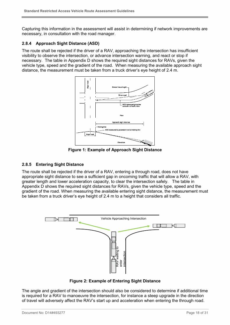
Capturing this information in the assessment will assist in determining if network improvements are necessary, in consultation with the road manager. 2.8.4 Approach Sight Distance (ASD) The route shall be rejected if the driver of a RAV, approaching the intersection has insufficient visibility to observe the intersection, or advance intersection warning, and react or stop if necessary. The table in Appendix D shows the required sight distances for RAVs, given the vehicle type, speed and the gradient of the road. When measuring the available approach sight distance, the measurement must be taken from a truck driver’s eye height of 2.4 m.
Figure 1: Example of Approach Sight Distance
2.8.5 Entering Sight Distance The route shall be rejected if the driver of a RAV, entering a through road, does not have appropriate sight distance to see a sufficient gap in oncoming traffic that will allow a RAV, with greater length and lower acceleration capacity, to clear the intersection safely. The table in Appendix D shows the required sight distances for RAVs, given the vehicle type, speed and the gradient of the road. When measuring the available entering sight distance, the measurement must be taken from a truck driver’s eye height of 2.4 m to a height that considers all traffic.
Figure 2: Example of Entering Sight Distance The angle and gradient of the intersection should also be considered to determine if additional time is required for a RAV to manoeuvre the intersection, for instance a steep upgrade in the direction of travel will adversely affect the RAV’s start up and acceleration when entering the through road.
RAV
wai
ting
to
ente
r in
ters
ectio
n
Vehicle Approaching Intersection

Standard Restricted Access Vehicle Route Assessment Guidelines
Document No: D14#493277 Page 19 of 31
Note: The entering sight distance requirement is only required for intersections that are not controlled by traffic signals, with the exception of a right turning movement with no right turn arrow. 2.9 Railway Level Crossings The various operational requirements at railway crossings are described in Main Roads ‘Railway Crossing Control in Western Australia Policy and Guidelines’ found on the Railway Crossing page of the Main Roads website. The following points highlight the main considerations for RAVs at railway crossings for the various levels of protection. 2.9.1 Inadequate Approach Stacking Distance Inadequate approach stacking distance occurs where the distance between the railway and a nearby intersection is insufficient to enable a vehicle to stop at the crossing without impeding the traffic flow at the intersection.
Approach stacking distance is measured from the vehicle stopping line at the railway crossing to the nearest shoulder edge of the crossroad. The vehicle stopping line at a railway crossing is normally indicated by a painted line or, in the absence of a marked line, assumed to be 3.5 m back from the nearest rail.
Figure 3: Examples of Inadequate Approach Stacking Distance
2.9.2 Inadequate Departure Stacking Distance Inadequate departure stacking distance occurs when part of a vehicle would encroach within 3.5 m of the railway track while stopped to give way to traffic on the priority road of an intersection located beyond the crossing. A possible exception is in cases where the intersection is controlled by traffic signals that are coordinated with the operation of the railway crossing signals.
Departure Stacking Distance is measured from the vehicle stopping line at the intersection to within 3.5 m of the nearest railway track. In the absence of marked lines, the measurement is to be taken from the edge of the through lane (if there are edge lines) or the edge of the seal.
Figure 4: Examples of Inadequate Departure Stacking Distance
Traffic is impeded by rear end of RAV protruding onto road
Potential collision between train and rear of RAV
3.5 m
Stop line Edge Line or
Edge of Seal

Standard Restricted Access Vehicle Route Assessment Guidelines
Document No: D14#493277 Page 20 of 31
2.9.3 Criterion for Assessing Whether Stacking Distance is Adequate Figure 5 shows the methodology for measuring approach (2.9.1) and departure (2.9.2) stacking distance. Ideally, a clearance of 3.5 m should be applied when assessing the available approach stacking distance. However, if the approach stacking distance is at least the length of the RAV and there is sufficient ESD for other vehicles departing the intersection while there is a RAV stopped at the rail, a lesser clearance is acceptable.
Figure 5: Examples of Adequate Stacking Distances
2.9.4 RAVs at Crossings Protected by Give Way or Stop Signs The driver of a RAV approaching a railway crossing protected by a GIVE WAY or a STOP sign needs to be able to see the crossing from a sufficient distance to allow enough time to stop the RAV if required. The ASD to a railway crossing must meet Appendix D. There also needs to be sufficient sight distance for the driver of a RAV, after having stopped at a railway crossing with a GIVE WAY or STOP sign, to see an oncoming train and allow adequate time to safely cross. The required sight distances for RAVs at railway crossings must meet:
• The S3 formula for STOP signs of the Australian Standards AS1742.7-2016 – Manual of Uniform Traffic Control Devices – part 7: Railway Crossings.
The S3 formula determines the minimum distance required for the driver of a vehicle stopped at the railway crossing to be able to see an oncoming train in order to safely cross. When measuring the available sight distance to all directions at rail crossings, a truck driver’s eye height of 2.4 m is recommended. Where railway crossings with STOP signs are located along the proposed route, the assessor must record the information shown below in Figure 6 on the RAV Route Assessment Form. This information is then used to calculate the S3 formula.

Standard Restricted Access Vehicle Route Assessment Guidelines
Document No: D14#493277 Page 21 of 31
Note: A Track Access Permit must be obtained from the relevant rail provider to access the rail corridor (outside the 3 metre zone).
Figure 6: Required Information from Onsite Assessment for S3 Calculation
2.9.5 RAVs at Railway Crossings Protected by Flashing Lights
The visibility of the primary flashing lights and advance flashing yellow warning signs displays on the approach to crossings must be assessed so that the driver can safely stop if required. The sight distance to the flashing lights, or alternatively the advance flashing yellow warning signs must meet the minimum requirements in Appendix D. When measuring the available sight distance to all directions at rail crossings, a truck driver’s eye height of 2.4 m is recommended. 2.10 Off-road Parking In rural and remote areas, the route should have adequate off-road truck parking facilities at sufficient spacing along the route. In any one direction of travel, the maximum spacing for off-road parking facilities is:
• Rural Area roads 80 km
• Remote Area roads 120 km
Adequate off-road parking facility is defined as any:
• Service station or roadhouse, (or other commercial establishment), with provision for public truck parking;
• Signed parking bay, truck bay, rest area; or
• Designated road train assembly area;
Which meets the following criteria:
• Minimum approach sight distance (measured from a truck driver’s eye height of 2.4 m) to the entry/exit point for traffic travelling on the through road are in accordance with Appendix D; and
• Minimum entering sight distance (measure from a truck driver’s eye height of 2.4 m to a height that considers all traffic.) from the entry/exit point in accordance with Appendix D; and
• The full length of the RAV can be parked without encroachment onto the carriageway. Minimum safe clearance distance of the RAV parked parallel to the road are shown in Table 9.

Standard Restricted Access Vehicle Route Assessment Guidelines
Document No: D14#493277 Page 22 of 31
Figure 7: Minimum clearance between road pavement and parking bay
Table 9: Minimum safe clearance distance of parked RAV from road
Speed Limit (km/h) Minimum Clearance from edge of pavement * (m)
60 5 70 5.7 80 6.2 90 7.6 100 8.8 110 11
* For parking facilities located on the outside of a curve, add a further 1.6 m to the normal minimum clearance. Depending on the frequency of trucks using the truck parking bays or road train assembly areas, the requirement of other facilities such as rubbish bins, tables and chairs and toilets needs to be considered. The assessor should also consider the likelihood of more than one RAV using the parking facility at any given time. This will depend on the volume of heavy vehicles on the proposed route. More information about off-road parking facilities can be obtained from Rest Areas page on the Main Roads website.
2.11 Other Road Users The key issues here are whether RAV operation will be highly incompatible with, or pose new risks to other road users that may not be familiar with or could be more vulnerable to RAVs. Road users that should be considered when assessing suitability include:
• Pedestrians (especially where there are school crossings);
• Cyclists;
• Tourists and recreational users (who may be unfamiliar with the conditions);
• School buses (where the frequent stopping and turning by buses and the presence of children on or adjacent to the road can pose potential hazards); and
• Farmers moving farm machinery and implements.
Safety is the primary factor for consideration. If crash history data is available, it may be useful to investigate whether certain times of the day engender particular risks, while at other times the risk is significantly lower. In these cases, it may be warranted to recommend that the RAV only use the route during the low-risk hours. RAVs can affect the flow of other traffic and contribute to congestion issues. Numbers of RAVs can reduce the speed of other traffic and in worst cases frustrate other motorists. Assessors should examine the traffic flow on the route and recommend solutions to reduce risks resulting from traffic disruption.

Standard Restricted Access Vehicle Route Assessment Guidelines
Document No: D14#493277 Page 23 of 31
Vehicles towing caravans or trailers are a significant issue in that they can find it difficult to pass RAVs. This situation is more prevalent during school holidays. Therefore the assessor should consider the impact of seasonal traffic changes during the assessment. If safety issues for other road users, which would result from RAV operation, are identified as major and cannot be suitably addressed, the route should be considered unsuitable for RAV access. 2.12 Slowing and Stopping The ability of vehicles to safely pull off the carriageway, e.g. to allow following vehicles to pass or to make repairs, should be examined. Continuous sections of the route with narrow shoulders and/or deep drains should be noted and comments made on any safety implications.
3 COMMUNITY CONSIDERATIONS Assessors need to consider potential community impacts as part of assessing route suitability. 3.1 Noise The assessor shall consider whether the introduction of the RAVs onto the route has potential to cause a significant noise impact by considering the following:
• Areas sensitive to road traffic noise, including residences, schools and hospitals;
• The likely number of RAVs in comparison to existing number of large trucks (3 or more axles);
• Factors contributing to noise generated by RAVs such as gradients (higher speeds or use of engine braking systems), acceleration/deceleration areas (higher engine speeds, gear changing or use of engine braking systems), and road pavement irregularities (body rattle); and
• Factors mitigating the impact of noise from RAVs such as distance to residences and any screening of residences by hills, cuttings or walls.
The main criterion for noise impact assessment is the change in the numbers of large trucks (3 or more axles) on the route. Doubling RAV numbers can be considered as the start of a significant noise change while quadrupling can be considered as very significant change. On very low volume roads, introducing RAVs may significantly increase numbers of large trucks, but overall truck numbers may still remain low enough so as not to cause a significant noise impact. Conversely, if the road is an existing heavy vehicle route, introducing RAVs or larger RAVs may reduce the number of trips required for a given freight task and improve noise issues. Consideration should also be given to potential noise impacts near a truck parking area. In particular, the noise generated by refrigerated trailers should be taken into account as these trucks are required to keep their cooling compressors running all night. Where noise impacts are expected to be significant the assessor shall consider options for mitigating noise impact, such as:
• Approved noise reduction request signs;
• A curfew for RAVs during night time hours;
• Consideration of alternative routes;
• Noise certification of RAVs as a condition of access; and

Standard Restricted Access Vehicle Route Assessment Guidelines
Document No: D14#493277 Page 24 of 31
• Speed restrictions.
Where noise impacts are expected to remain significant and mitigation actions have been implemented, Main Roads will consult with the relevant Local Government and may undertake a noise impact study of the route. 3.2 Vibration Where the RAV route passes close to abutting development there may be adverse impacts upon people and property due to vibration. The assessor shall consider whether the introduction of the RAVs onto the route has potential to cause significant vibration impact by considering:
• Distance to buildings and their use and condition;
• Road roughness; and
• Uneven drainage gullies and manhole covers.
Where vibration impacts are expected to be significant the assessor shall consider options to mitigate the impacts, such as road surface improvements and alternative routes. 3.3 Dust and dirt Where the RAV route passes close to abutting development there may be adverse impacts upon people and property due to dust, especially where a route is unsealed. The assessor shall consider whether the introduction of the RAVs onto the route has potential to cause significant dust impact by considering:
• Distance to buildings and their use;
• Likely numbers of RAVs using the route; and
• Likelihood of significant amounts of dust being produced by RAVs.
RAVs entering onto a seal road from a dirt road will potentially carry the dirt onto the sealed road, particularly in wetter conditions. This results in dirt building up and spreading on the road, which impacts on other motorists. Where dust and dirt impacts are expected to be significant the assessor shall consider options to mitigate the impacts, such as alternative routes, speed restrictions and possibly sealing road sections, particularly on the approach to a sealed road. 3.4 Community Consultation In line with Government policy, Main Roads may require a route that has been given a favourable assessment using these guidelines to undergo a community consultation phase. Main Roads, with input from the relevant local government, will determine the need for community consultation on a case-by-case basis. 3.5 Alternative Transport Modes Alternative transport modes need to be considered to ensure RAV road transport is the most effective form of transport available for the particular operation.

Standard Restricted Access Vehicle Route Assessment Guidelines
Document No: D14#493277 Page 25 of 31
4 APPENDICES Appendix Title
A Rural Road Minimum Widths
B Low Volume Rural Road Minimum Widths
C Townsite Road Minimum Widths
D Required Sight Distance
E Operating Conditions
F RAV Access Assessment Process

Standard Restricted Access Vehicle Route Assessment Guidelines
Document No: D14#493277 Page 26 of 31
Appendix A: Rural Road Minimum Width
60 to 70 km/h 80 to 100 km/h
Carriageway Width*
(m)
Sealed Width**
(m)
Carriageway Width*
(m)
Sealed Width**
(m)
0 to 150 AADT / VPD*** RAVs Categories 2-4 7.6 3.3 7.9 3.4
RAVs Categories 5-7 7.7 3.4 8.0 3.5
RAVs Categories 8-10 8.2 3.8 8.6 3.9
150 to 500 AADT / VPD
RAVs Categories 2-4 7.6 5.6 7.9 5.9
RAVs Categories 5-7 7.7 5.7 8.0 6.0
RAVs Categories 8-10 8.2 6.1 8.6 6.4
500 to 1 000 AADT RAVs Categories 2-4 7.9 6.1 8.2 6.4
RAVs Categories 5-7 8.0 6.2 8.3 6.5
RAVs Categories 8-10 8.6 6.6 9.0 6.9
More than 1 000 AADT
RAVs Categories 2-4 9.6 6.8 9.9 7.1
RAVs Categories 5-7 9.7 6.9 10.0 7.2
RAVs Categories 8-10 10.6 7.6 11.0 8.0
* The carriageway widths given in the above table should be used for assessing usable width on gravel roads. ** A road should be sealed if AADT over 150 and annual freight tonnage over 300,000 TPA. In the absence of any data, the following parameters may be a guide: • uniform annual loaded RAV traffic volume more than 10 vehicles per day; or • loaded RAV traffic volume more than 60 vehicles per day over a seasonal two month period. *** When the road width is below the above values and traffic volume is no more than 75 VPD, the route may be suitable for RAVs Categories 2-10 (excluding 8) access as a low volume road. Refer to Appendix B on the following page.

Standard Restricted Access Vehicle Route Assessment Guidelines
Document No: D14#493277 Page 27 of 31
Appendix B: Low Volume Rural Road Minimum Widths NB: This section is not to be used for assessing routes for RAV Category 8. Type A Road (suitable for two-way RAV traffic)
40 km/h 60 km/h
Carriageway Width (m) Carriageway Width (m)
RAVs Categories 2-7 5.8 6.1*
RAVs Categories 9-10 5.9 6.3*
For Type A low volume roads, Appendix E operating conditions 1, 2, 3, 4, 5, 7 and 8 may be applied as a condition; *If a road is at least 1.0 m wider than these widths, an 80km/h speed restriction should be considered. A speed restriction above 80km/h should only be considered if the road is sealed, has good sight distance and presents no significant safety concern.
Type B Road (unsuitable for two-way RAV traffic)
40 km/h
Carriageway Width (m)
RAVs Categories 2-7 3.5*
RAVs Categories 9-10 3.5*
For type B low volume roads, Appendix E operating conditions 1, 2, 3, 4, 5, 6, 7 and 8 may be applied as a condition. *Maximum road length limits apply, refer to Table 2 in Section 2.4.

Standard Restricted Access Vehicle Route Assessment Guidelines
Document No: D14#493277 Page 28 of 31
Appendix C: Town Site Road Minimum Widths
Feature RAVs Categories 2-4 RAVs Categories 5-8 RAVs Categories 9-10
60 - 70 80-100 60 - 70 80-100 60 - 70 80-100 km/h km/h km/h km/h km/h km/h
(Undivided carriageway – 2 Way) Width between sealed edge and road centre (m) Basic / unmarked 3.2 3.5 3.3 3.7 3.6 4.1
with marked separation line 3.5 3.8 3.6 4.0 3.9 4.4
with dedicated cycle lane 4.7 5.5 4.8 5.7 5.1 6.1
with dedicated or regular parallel parking 5.7 NA 5.8 NA 6.1 NA
with dedicated angle (45o) parking 9.2 NA 9.3 NA 9.6 NA
(Divided carriageway – single lane) Width between sealed edge and edge of median or traffic island (m) Basic / unmarked 3.5 3.8 3.6 4.0 3.9 4.4
with dedicated cycle lane 5.0 5.8 5.1 6.0 5.4 6.4
with dedicated or regular parallel parking 6.0 NA 6.1 NA 6.4 NA
with dedicated angle (45o) parking 9.5 NA 9.6 NA 9.9 NA
(Undivided carriageway – 2 lanes) Width between sealed edge and road centre (m)
Basic / unmarked 6.6 7.0 6.7 7.1 7.0 7.5
with dedicated cycle lane 8.1 9.0 8.2 9.1 8.5 9.5
with dedicated or regular parallel parking 9.1 NA 9.2 NA 9.5 NA
(Divided carriageway – 2 lanes) Width between sealed edge and edge of median or traffic island (m)
Basic / unmarked 6.6 7.0 6.7 7.1 7.0 7.5
with dedicated cycle lane 8.1 9.0 8.2 9.1 8.5 9.5
with dedicated or regular parallel parking 9.1 NA 9.2 NA 9.5 NA
(Multiple Lane Carriageways – 3 or more lanes) Width of additional through lane (m)
basic 3.2 3.4 3.3 3.5 3.4 3.6 Notes:
1) Speed refers to the prevailing speed limit for the road
2) An explanation of road type descriptors follows:

Standard Restricted Access Vehicle Route Assessment Guidelines
Document No: D14#493277 Page 29 of 31
Appendix D: Required Sight Distances Posted
Speed km/h 0BDownhill 1BLevel 2BUphill
-8% -6% -4% -2% 2% 4% 6% 8%
40 74 72 70 68 66 65 64 62 61
50 102 98 95 92 89 87 85 84 82
60 134 128 123 119 116 112 110 107 105
70 170 162 155 149 144 140 136 133 130
80 209 198 190 182 176 170 165 161 157
90 252 239 228 218 210 203 197 191 186
100 308 290 275 263 252 242 234 227 220 The above values have been derived using the formula given in Austroads Guidelines with following factors:
(Deceleration rate of 0.29g up to 90 km/h, 0.28g at 100 km/h.)
Reaction Time 4.0 s

Standard Restricted Access Vehicle Route Assessment Guidelines
Document No: D14#493277 Page 30 of 31
Appendix E: Operating Conditions Main Roads will apply the operating conditions below, as a condition of permit, to very low traffic volume roads when the road’s width does not meet the minimum requirements in Appendix A. These and other similar operating conditions may be applied to the assessment of other roads. 1. When travelling at night, the RAV must travel at a maximum speed of 40km/h and display an
amber flashing warning light on the prime mover. 2. No operation on unsealed road segment when visibly wet, without road owner’s approval. 3. Headlights must be switched on at all times. 4. Speed restrictions. * 5. Direct radio contact must be maintained with other RAVs to establish their position on or near
the road (suggested UHF Ch 40). 6. For a single lane road, the road must not be entered until the driver has established via radio
contact that there is no other RAV on the road travelling in the oncoming direction. 7. Operation is not permitted while the school bus is operating on the road. Operators must
contact the relevant schools directly and obtain school bus timetables; or where direct contact can be made with the school bus driver, operation is permitted once the school bus driver confirms all school drop-offs/ pick-ups have been completed on the road.
8. Current written support from the road asset owner, endorsing use of the road, must be obtained, carried in the vehicle and produced upon request.
These conditions are applied in the Prime Mover, Trailer Combinations and Truck, Trailer Combinations Operating Conditions. The applicable roads must be clearly identified as either a “Type A” Low Volume Road or a “Type B” Low Volume Road or appropriate conditions listed separately as a road condition. *40 km/h or 60 km/h as determined from Appendix B.

Standard Restricted Access Vehicle Route Assessment Guidelines
Document No: D14#493277 Page 31 of 31
Appendix F: RAV Access Assessment Process
Step 1•The "Application and Road Owner Support to Add or Amend a road on the RAV Network" is received by HVS.
Step 2•HVS liaises with the relevant road manager for a preliminary assessment and comment in relation to public amenity, the road condition and future development plans.
Step 3•Onsite assessment / data collection is conducted in accordance with Route Assessment Guidelines.
Step 4•HVS undertakes a review of the onsite assessment data and presents the outcomes at a Network Management Meeting.
Step 5
•The Network Management Committee considers the data in accordance with the Guidelines for Approving RAV Access, taking into consideration impacts on safety, network performance, road infrastructure and other relevant factors / policies.
Step 6•The final recommendation is then presented to HVS Senior Management, who approves / declines the recommendation.
Step 7•The applicant and road manager will be informed of the outcome and the road will be added to the relevant RAV Network or Permit, if applicable.


![SendMsg · Rav Shlomo Zalman of Volozhin, brother of Rav Chaim Volozhin ( Y _ ] ^- Y _ ` `). Rav Yitzchak ben Rav Shem Tov Ibn Wallid, author of VaYomer Yitzchok. Rav Shmuel Shmelka](https://img.pdfslide.net/doc/110x75/60a400daadef77314e312e59/sendmsg-rav-shlomo-zalman-of-volozhin-brother-of-rav-chaim-volozhin-y-.jpg)