Embed Size (px)
Citation preview
Stantec Consulting Ltd.
300 - 675 Cochrane Drive West Tower
Markham ON L3R 0B8
Tel: (905) 944-7777
Fax: (905) 474-9889
June 13, 2014
File: 160900764
Attention: Mr. Paul Dalmazzi
HydroOne
Environmental Engineering and Project Support
483 Bay Street, 6th Floor, South Tower
Toronto, ON M5G 2P5
Dear Mr. Dalmazzi,
Reference: Groundwater and Surface Water Monitoring Program, Clarington Transformer Station
Stantec Consulting Ltd. (Stantec) is pleased to submit to Hydro One Networks Inc. (Hydro One) our
Groundwater and Surface Water Monitoring Program for the Clarington Transformer Station. The
transformer station is to be located on Hydro One property (‘Project Area’) located in the
Regional Municipality of Durham, in the Municipality of Clarington, on Part Lots 33, 34, and 35,
Concession Road #7. The Project Area and the extents of the transformer station itself, hereinafter
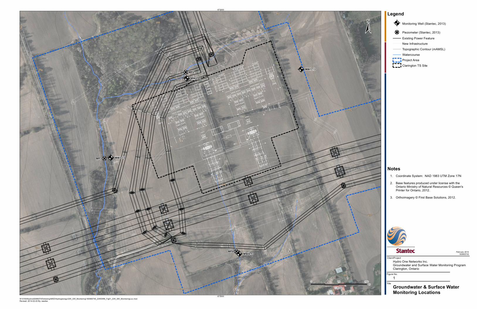
referred to as the ‘Site’, are shown on Figure 1.
BACKGROUND
In their Class EA Project Environmental Study Report (Project ESR), Hydro One has committed to
undertake a groundwater and surface water monitoring program that includes monitoring wells
and surface water monitoring locations within its property boundaries (Project Area), and offering
private well monitoring to well owners on properties immediately adjacent to the Site. This
commitment is to cover pre, during, and post transformer station construction periods, and will
include monitoring of water levels and water quality.
Stantec compiled available geotechnical and hydrogeological information as well as reviewed
Ontario Ministry of the Environment (MOE) water well records, Ontario Geological Survey
mapping, Oak Ridges Moraine Conservation Plan, and Ministry of Affairs and Housing Greenbelt
Plan. Stratigraphy beneath the Site is found to consist of silt till overburden which is known as the
Newmarket Till, with pockets of Halton Till at surface. The till contains occasional isolated sand to
silty sand lenses, with several nearby private wells reportedly installed within these lenses. The MOE
water well record database indicates the presence of a deep (greater than 75 m below ground
surface) silty sand aquifer consisting of medium to fine sand and gravel which is regionally
recognized as the Thorncliffe Aquifer.
OBJECTIVES
The following Groundwater and Surface Water Monitoring Program has three primary objectives:
to fulfill Hydro One’s commitment to implement a pre, during, and post transformer station
construction groundwater and surface water monitoring program; to refine our understanding of
the physical and chemical characteristics of the shallow and intermediate depth groundwater
systems at the Site; and to establish a pre-construction baseline of groundwater conditions,
including seasonal variations of groundwater quality, quantity, and surface water / groundwater
interaction. The monitoring data collected will provide the technical foundation on which to
assess whether adverse impacts occurred during or post construction.
June 13, 2014
Mr. Paul Dalmazzi
Page 2 of 8
Reference: Groundwater and Surface Water Monitoring Program, Clarington Transformer Station
MONITORING PROGRAM SCOPE
The Groundwater and Surface Water Monitoring Program includes several key tasks, including
installing new groundwater monitoring wells (completed in Fall 2013), implementing a private well
monitoring program, surface water monitoring, decommissioning of geotechnical monitoring wells
(completed Fall 2013), water level and water quality monitoring, and preparing annual monitoring
summary reports through the duration of the monitoring program.
Complementing the groundwater monitoring program, surface water features located on the
north (wetland), west (creek), and south (drainage swale) sides of the Site will be monitored.
Background water levels within three newly installed shallow piezometers (mini shallow wells) will
be recorded prior to construction of the transformer station, and compared to monitoring results
recorded during and post construction. The monitoring data collected will provide the technical
foundation on which to further characterize our understanding of the shallow groundwater
system, to assess whether adverse impacts occurred during or post construction, and to provide
guidance for appropriate mitigation, if needed.
Owners of private wells on properties immediately adjacent to the east and south of the Site will
be able to have the water level and water quality in their wells monitored prior to, during, and
post construction of the transformer station. A baseline of seasonal normal groundwater levels
and groundwater quality will be established prior to construction of the transformer station. Once
construction of the transformer station begins, the well monitoring program will continue with
observations compared to baseline conditions, allowing for an assessment of potential impacts on
the natural environment and of the efficacy of the engineered containment structures and water
treatment systems to be installed.
Groundwater and surface water data collected prior to construction of the transformer station will
help define the relationship between the shallow and intermediate depth groundwater systems at
the Site and how they interact with each other; providing a baseline to which monitoring data
collected during construction and post construction will be compared. Specifically, the
Groundwater and Surface Water Monitoring Program will allow for quantification of the following
hydrogeological characteristics of the site:
Refinement of Site geologic stratigraphy;
Seasonal shallow and intermediate groundwater water levels across the site;
Seasonal shallow and intermediate groundwater chemistry;
Vertical groundwater gradients (identify areas of upward, neutral, or downward groundwater
movement) between surface water and shallow groundwater system, and shallow and
intermediate depth groundwater systems;
Shallow and intermediate depth hydraulic conductivity, including variations in hydraulic
conductivity associated with the different geologic materials identified during previous and
recent drilling programs;
Continuous (hourly) groundwater level monitoring to allow for observation and calculation of
seasonal variations in surface water, groundwater, and private wells; and,
Potential changes in shallow groundwater elevation associated with the cut portion (east side)
of the grading area, including the potential radius of groundwater influence, and potential for
private well interference.
June 13, 2014
Mr. Paul Dalmazzi
Page 3 of 8
Reference: Groundwater and Surface Water Monitoring Program, Clarington Transformer Station
The hydrogeologic conditions presented in the Project ESR will be confirmed through the analyses
and interpretation of groundwater and surface water data collected prior to construction of the
transformer station. The monitoring program will continue during and post construction of the
transformer station in order to confirm that the mitigation measures and engineered containment
structures designed to protect the natural form and function of the surface water system, shallow
and intermediate groundwater systems, and the adjacent private water wells are functioning as
designed.
MONITORING INSTALLATIONS
The Groundwater and Surface Water Monitoring Program takes into consideration potential
adverse impacts of the project on the natural environment in the absence of implementing any
mitigations measures (containment structures, water treatment, etc.). These include the
introduction of chemical substances and changes to the natural form and function of the shallow
and intermediate depth groundwater and surface water systems. As a result, the depths of the
monitoring wells, monitoring frequency, and selected water quality analyses of the entire
monitoring program have been selected with detection of potential changes to these receptors
as their primary objective.
Site Monitoring Wells
The groundwater monitoring wells installed at the Site during the previous geotechnical
investigations were all installed at an intermediate depth (screened between approximately 11 m
and 15 m depth). These monitoring wells were located where excavations for footings or
foundations are planned, and as a result, needed to be decommissioned prior to construction of
these foundations.
In the Fall of 2013, this monitoring program was initiated by installing pairs of new monitoring wells
on each side of the Site (Figure 1). The new intermediate depth (approximately 10 m to 15 m
depth) wells have been paired with shallow depth wells (approximately 1 m to 3 m depth)
intended to intersect the elevation of the shallow water table. By installing pairs of shallow and
intermediate depth wells, changes in groundwater levels, groundwater chemistry and vertical
hydraulic gradients (upward or downward movement of groundwater) will be able to be
measured and monitored seasonally prior to, during, and post construction of the transformer
station.
Drive point piezometers (shallow mini wells) have also been installed within the Site’s surface water
features in order to monitor seasonal shallow groundwater and surface water levels within the
wetland (north side), creek (west side) and drainage swale (south side) features found on-Site.
June 13, 2014
Mr. Paul Dalmazzi
Page 4 of 8
Reference: Groundwater and Surface Water Monitoring Program, Clarington Transformer Station
The new groundwater monitoring wells were installed according to the MOE Water Resource Act
(O. Reg. 903). A licensed well drilling contractor was retained and has completed the following:
Installation of three (3) stream/wetland drive-point piezometers;
Drilling and installation of four (4) shallow and intermediate depth pairs of groundwater
monitoring wells (8 wells in total); advanced to depth of approximately 1 to 3 m and 10 to
15 m, respectively;
Complete grouting (sealing) of outer well annulus;
Installation of protective and lockable well casing; and,
Decommissioning of former geotechnical wells according to the MOE Water Resource Act
(O. Reg. 903).
Upon completing installation of the new monitoring wells in December 2013, the water level in
several wells were observed to have recovered slowly, with some not recovering sufficiently after
several days to allow for a collection of water quality samples. Monitoring of the new wells will
continue with the completion of a water level monitoring event in Winter 2014, noting if any wells
are frozen.
In Spring 2014, the new wells will be developed, hydraulically tested (slug tests) to confirm
estimates presented in the Project ESR, and sampled for groundwater quality. Selected
representative soil samples obtained and preserved during drilling will be submitted for laboratory
sieve grain size analyses.
Private Well Monitoring
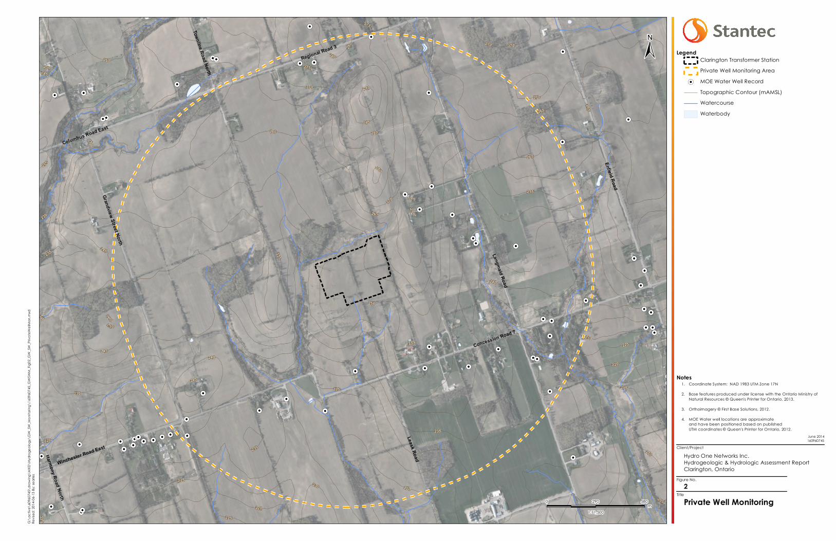
The private well monitoring program will include providing notification to all potential groundwater
users within 1,200 m of the Site, informing the property and/or well owners of the transformer
station construction schedule, and the parameters of the private well monitoring program.
The distributed notification information will provide the details of the monitoring program, and
include appropriate project contact information for Hydro One regarding construction concerns.
During the door-to-door site visits, Stantec will also make note of and attempt to contact well
owners that may not appear in the MOE’s records for the purpose of offering participation in the
private well monitoring program.
Participation in the private well monitoring program will only be completed with the owner’s
authorization, and will include water quality sampling and water level monitoring, depending on
well accessibility. Water level monitoring involves installing an automated well water level logger
(pressure transducer), which can only be completed at accessible wells by a licensed well
contractor. The automated loggers will monitor ‘continuous’ water levels (at 5 to 60 minute
intervals) from Spring 2014 until two years following completion of construction. The loggers would
be removed at the end of the monitoring program.
June 13, 2014
Mr. Paul Dalmazzi
Page 5 of 8
Reference: Groundwater and Surface Water Monitoring Program, Clarington Transformer Station
Private well water quality samples will be collected from a raw water tap (prior to any treatment
or filtration), where available. If no raw water tap is present, a sample may be collected directly
from the well, depending on well accessibility and well owner authorization. After purging water
from the well, the samples will be collected directly into laboratory supplied sample containers.
The samples will not be field filtered and will be submitted for general chemistry, turbidity, metals,
hydrocarbons (F1-F4 and BTEX), and bacteriological analyses. To supplement and provide quality
assurance, temperature, conductivity, and pH data will be collected in the field at the time of
sampling.
Individual private well analytical results will be presented in a letter to each resident following
each sampling event along with the available water level data. Private well data will remain
confidential, and is not permitted to be shared with the general public. However, monitoring
reports for data collected on-Site will be prepared annually and made available to the public by
Hydro One.
SURFACE WATER MONITORING
A Stantec terrestrial ecologist will monitor the Site prior to transformer station construction to
confirm the presence or absence of groundwater seeps within the Project Area, identifying
notable indicator parameters and plant species. Ecological monitoring will continue annually
during construction of the transformer station, and for two years following completion of
construction. Surface water levels and water quality samples will be collected from three (3)
surface water monitoring locations (at piezometer installation locations) and submitted for
laboratory analyses following the monitoring schedule discussed below.
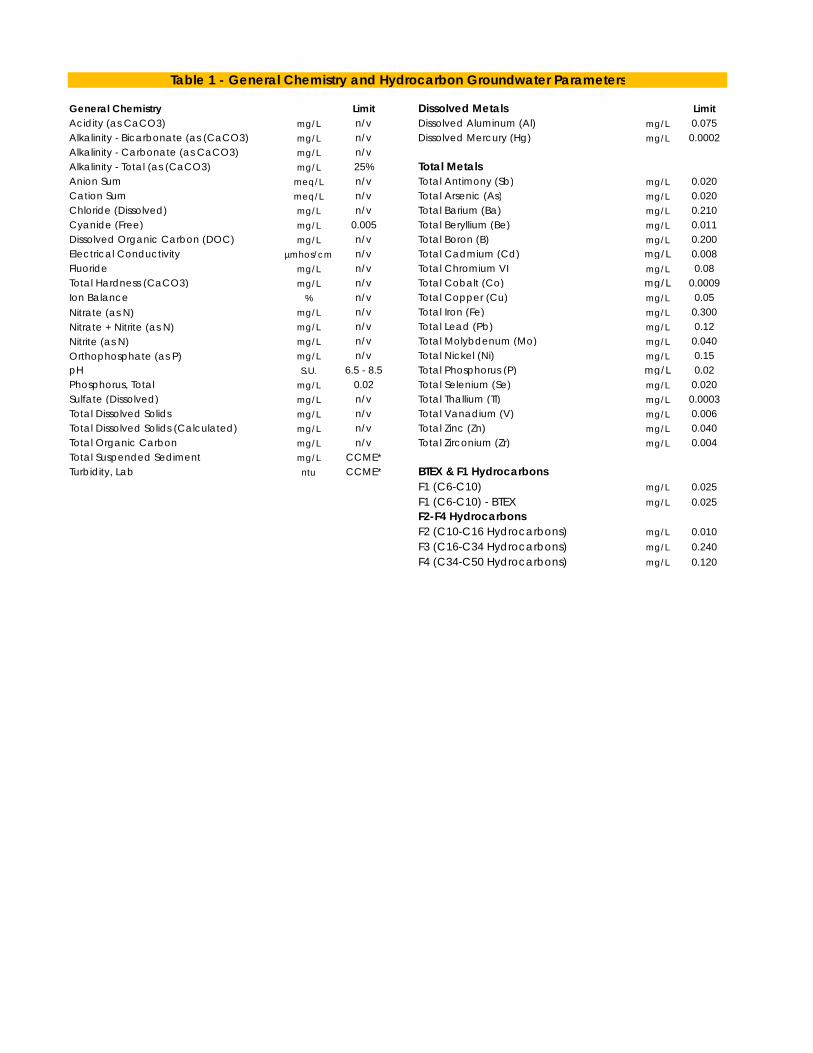
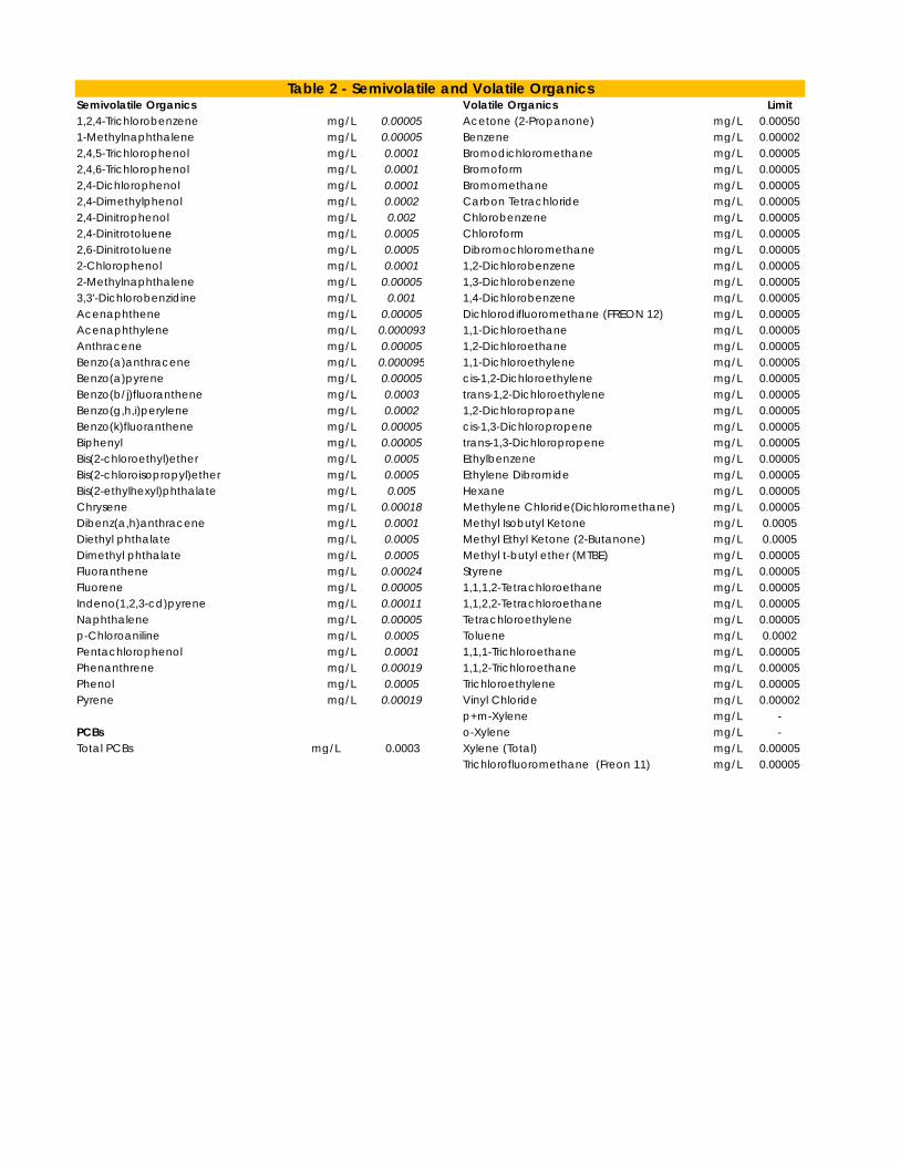
WATER QUALITY ANALYSES
Groundwater water quality samples from each of the new on-Site monitoring wells and
participating private wells will be collected according to laboratory protocols, preserved, and
submitted for laboratory analyses (general chemistry, metals, and hydrocarbons (F1-F4 and BTEX))
to Maxxam Analytics, an accredited laboratory. Well water quality parameter analyses will be
compared to Ontario Drinking Water Quality Standards (ODWQS).
Surface water quality samples will be collected from each of the three new surface water
monitoring locations adjacent to the new piezometer installations (when surface water is present)
according to laboratory protocols, preserved, and submitted for laboratory analyses (general
chemistry, metals, and hydrocarbons (F1-F4 and BTEX)) to Maxxam Analytics. Surface water
quality parameter analyses will be compared to Provincial Water Quality Objectives (PWQO).
A water quality parameter list is included in the attached Tables 1 and 2.
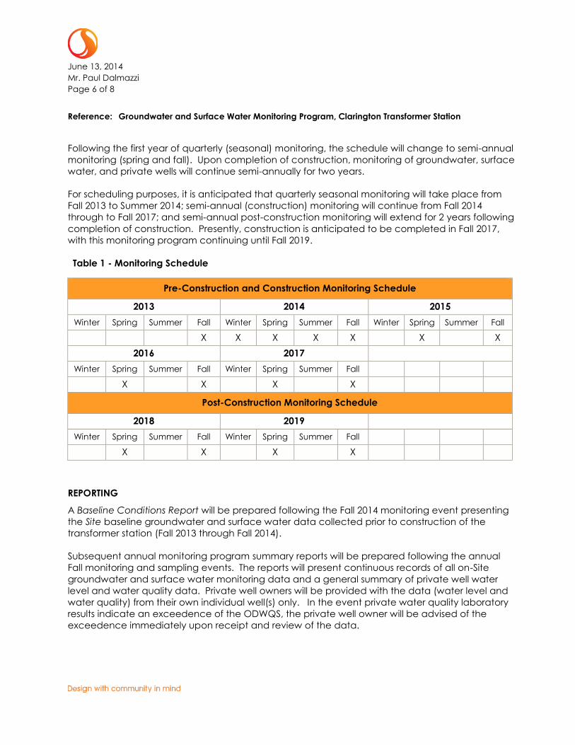
MONITORING SCHEDULE
The Groundwater and Surface Water Monitoring Program schedule frequency is designed to
record groundwater levels continuously with the use of automated pressure transducers, and to
seasonally (quarterly) collect groundwater and surface water quality samples for laboratory
analyses for the first year of monitoring in order to establish potential seasonal variations in
groundwater levels and chemistry. Table 1 presents the program water quality sampling schedule.
June 13, 2014
Mr. Paul Dalmazzi
Page 6 of 8
Reference: Groundwater and Surface Water Monitoring Program, Clarington Transformer Station
Following the first year of quarterly (seasonal) monitoring, the schedule will change to semi-annual
monitoring (spring and fall). Upon completion of construction, monitoring of groundwater, surface
water, and private wells will continue semi-annually for two years.
For scheduling purposes, it is anticipated that quarterly seasonal monitoring will take place from
Fall 2013 to Summer 2014; semi-annual (construction) monitoring will continue from Fall 2014
through to Fall 2017; and semi-annual post-construction monitoring will extend for 2 years following
completion of construction. Presently, construction is anticipated to be completed in Fall 2017,
with this monitoring program continuing until Fall 2019.
Table 1 - Monitoring Schedule
Pre-Construction and Construction Monitoring Schedule
2013 2014 2015
Winter Spring Summer Fall Winter Spring Summer Fall Winter Spring Summer Fall
X X X X X X X
2016 2017
Winter Spring Summer Fall Winter Spring Summer Fall
X X X X
Post-Construction Monitoring Schedule
2018 2019
Winter Spring Summer Fall Winter Spring Summer Fall
X X X X
REPORTING
A Baseline Conditions Report will be prepared following the Fall 2014 monitoring event presenting
the Site baseline groundwater and surface water data collected prior to construction of the
transformer station (Fall 2013 through Fall 2014).
Subsequent annual monitoring program summary reports will be prepared following the annual
Fall monitoring and sampling events. The reports will present continuous records of all on-Site
groundwater and surface water monitoring data and a general summary of private well water
level and water quality data. Private well owners will be provided with the data (water level and
water quality) from their own individual well(s) only. In the event private water quality laboratory
results indicate an exceedence of the ODWQS, the private well owner will be advised of the
exceedence immediately upon receipt and review of the data.

June 13, 2014
Mr. Paul Dalmazzi
Page 7 of 8
Reference: Groundwater and Surface Water Monitoring Program, Clarington Transformer Station
IMPLEMENTATION
A Community Liaison Committee (CLC) was formed on May 29, 2014 and conducted its first
meeting on June 5, 2014. The committee consists of representatives from HydroOne, local
environmental organizations, local area residents and three First Nations. CLC meetings are also
open to any other organizations and/or members of the public to observe, and observers are also
given the opportunity to ask questions or to comment at the conclusion of each meeting. The CLC
provides a forum for the exchange and dissemination of project information between Hydro One
and the local community, as per Condition 5.1 of the Minister of the Environment’s decision to
deny the Part II Order Requests received for the Clarington TS Class Environmental Assessment.
CLC meetings will be the primary avenue for Hydro One to disseminate monitoring information
and results to community members. A presentation was made at the initial CLC meeting on June
5, 2014 introducing the Monitoring Program, and questions and comments were received from
CLC members and observers. The next CLC meeting is planned for late Fall 2014, in advance of
the start of site grading and construction of the Clarington Transformer Station itself. The Baseline
Conditions Report will be provided to the MOE, CLOCA, and CLC stakeholders in advance of the
Fall 2014 meeting for review.
Hydro One will also actively disseminate information and engage in dialogue with members of the
community through avenues other than the CLC. Hydro One will share information and interact
with the community through newspaper ads, Project newsletters, personal communications with
interested stakeholders, a dedicated project hotline and email inbox, and a project website:
(http://www.hydroone.com/Projects/Clarington/Pages/default.aspx).
Hydro One will also be employing a dedicated Community Liaison Officer to be on-site during the
construction phase of the project. All of the above-mentioned avenues for communication with
the community will be used to share information about the Monitoring Program progress and
results, where necessary.
The Monitoring Program will be adaptive. Changes to the monitoring program and/or laboratory
analyses may be implemented, as determined by Hydro One and its environmental consultant,
subject to approval of the MOE Central Region Director, with consideration of the monitoring
results and professional interpretations derived from them. HydroOne will continue to encourage
input from regulatory agencies, CLC stakeholders, and individual well owners as this project
progresses from pre-construction through to completion and on to post-construction monitoring.
June 13, 2014
Mr. Paul Dalmazzi
Page 8 of 8
Reference: Groundwater and Surface Water Monitoring Program, Clarington Transformer Station
CLOSURE
This Groundwater and Surface Water Monitoring Program will fulfill the environmental monitoring
commitments made by Hydro One in the Project’s ESR by establishing background
hydrogeological conditions and by providing a monitoring program that will identify and monitor
the natural form and function of the shallow and intermediate depth groundwater system during
and post construction.
Regards,
STANTEC CONSULTING LTD.
J. Brant Gill, H.B.Sc., P.Geo.
Senior Hydrogeologist Phone: (905) 415-6330
Fax: (905) 474-9889
Attachment: Figure 1 – Groundwater and Surface Water Monitoring Locations
Figure 2 – Private Well Monitoring Program Area
Table 1 – General Chemistry and Hydrocarbon Water Quality Parameters
Table 2 – Semi-VOC and VOC Water Quality Parameters
c. Dan Eusebi - Stantec
jbg let_MOE-GW-SW Monitoring Program_13Jun2014_FINAL.docx
"́"́
"́
"́
"%²
"%²
"%²
MW1-13
MW2-13
MW3-13
MW4-13
MP2
MP3
MP4
255
250
235
255
255
235
265
260
250
255
255
240
250
245
673000
673000
Client/Project
Figure No.
Title Groundwater & Surface WaterMonitoring Locations
1
Hydro One Networks Inc.Groundwater and Surface Water Monitoring ProgramClarington, Ontario
February 2014160960745
Notes
Legend
1.2.
3.
Coordinate System: NAD 1983 UTM Zone 17NBase features produced under license with theOntario Ministry of Natural Resources © Queen'sPrinter for Ontario, 2012.Orthoimagery © First Base Solutions, 2012.
0 75 150m
1:3,000
"́Monitoring Well (Stantec, 2013)
"%² Piezometer (Stantec, 2013)Existing Power FeatureNew InfrastructureTopographic Contour (mAMSL)WatercourseProject AreaClarington TS Site
W:\01609\active\60960745\drawing\MXD\Hydrogeology\GW_SW_Monitoring\160960745_GWSWM_Fig01_GW_SW_MonitoringLoc.mxdRevised: 2014-02-20 By: searles
±
"¹
"¹
"¹
"¹
"¹
"¹
"¹
"¹"¹"¹ "¹
"¹
"¹
"¹
"¹
"¹
"¹
"¹
"¹
"¹
"¹
"¹
"¹
"¹
"¹
"¹
"¹
"¹
"¹
"¹
"¹
"¹
"¹
"¹
"¹
"¹
"¹"¹
"¹
"¹"¹"¹
"¹
"¹"¹"¹
"¹
"¹
"¹
"¹
"¹"¹
"¹"¹"¹
"¹
"¹
"¹
"¹
"¹"¹
"¹
"¹
"¹
"¹
"¹
"¹
"¹
"¹
"¹
"¹
"¹
"¹
Winchester Road East
Langmaid Road
Enfield Road
Harmony Road North
Townline Road North
Concession Road 7
Columbus Road East
Leask Road
Regional Road 3
Grandview Street North
250
250
250
265
2 30
215
2
7 0
27 0
245
280
215
280
270
25 5
290
245
255
270
235
280
265
230
2 50
205
230
270
220
2 85
260
255
240
235
220
245
210
280
270
275
275
220
270
215
220
225
225
225
230
265
265
230
260
235
240
255
245
250
Client/Project
Figure No.
TitlePrivate Well Monitoring2
Hydro One Networks Inc.Hydrogeologic & Hydrologic Assessment ReportClarington, Ontario
June 2014160960745
Notes
Legend
1.
2.
3.
4.
Coordinate System: NAD 1983 UTM Zone 17N
Base features produced under license with the Ontario Ministry of Natural Resources © Queen's Printer for Ontario, 2013.
Orthoimagery © First Base Solutions, 2012.
MOE Water well locations are approximate and have been positioned based on published UTM coordinates © Queen's Printer for Ontario, 2012.
0 290 580m
1:11,500
Clarington Transformer StationPrivate Well Monitoring Area
"¹ MOE Water Well RecordTopographic Contour (mAMSL)WatercourseWaterbody
G:\a
ctive
\609
6074
5\dr
awing
\MXD
\Hyd
roge
ology
\GW
_SW
_Mon
itorin
g\16
0960
745_
GWSW
M_Fig
02_G
W_S
W_P
rivat
eWell
Mon.m
xdRe
vised
: 201
4-06-1
3 By:
sear
les
±
General Chemistry Limit Dissolved Metals LimitAcidity (as CaCO3) mg/L n/v Dissolved Aluminum (Al) mg/L 0.075Alkalinity - Bicarbonate (as (CaCO3) mg/L n/v Dissolved Mercury (Hg) mg/L 0.0002Alkalinity - Carbonate (as CaCO3) mg/L n/vAlkalinity - Total (as (CaCO3) mg/L 25% Total MetalsAnion Sum meq/L n/v Total Antimony (Sb) mg/L 0.020Cation Sum meq/L n/v Total Arsenic (As) mg/L 0.020Chloride (Dissolved) mg/L n/v Total Barium (Ba) mg/L 0.210Cyanide (Free) mg/L 0.005 Total Beryllium (Be) mg/L 0.011Dissolved Organic Carbon (DOC) mg/L n/v Total Boron (B) mg/L 0.200Electrical Conductivity µmhos/cm n/v Total Cadmium (Cd) mg/L 0.008Fluoride mg/L n/v Total Chromium VI mg/L 0.08Total Hardness (CaCO3) mg/L n/v Total Cobalt (Co) mg/L 0.0009Ion Balance % n/v Total Copper (Cu) mg/L 0.05Nitrate (as N) mg/L n/v Total Iron (Fe) mg/L 0.300Nitrate + Nitrite (as N) mg/L n/v Total Lead (Pb) mg/L 0.12Nitrite (as N) mg/L n/v Total Molybdenum (Mo) mg/L 0.040Orthophosphate (as P) mg/L n/v Total Nickel (Ni) mg/L 0.15pH S.U. 6.5 - 8.5 Total Phosphorus (P) mg/L 0.02Phosphorus, Total mg/L 0.02 Total Selenium (Se) mg/L 0.020Sulfate (Dissolved) mg/L n/v Total Thallium (Tl) mg/L 0.0003Total Dissolved Solids mg/L n/v Total Vanadium (V) mg/L 0.006Total Dissolved Solids (Calculated) mg/L n/v Total Zinc (Zn) mg/L 0.040Total Organic Carbon mg/L n/v Total Zirconium (Zr) mg/L 0.004Total Suspended Sediment mg/L CCME*Turbidity, Lab ntu CCME* BTEX & F1 Hydrocarbons
F1 (C6-C10) mg/L 0.025F1 (C6-C10) - BTEX mg/L 0.025F2-F4 HydrocarbonsF2 (C10-C16 Hydrocarbons) mg/L 0.010F3 (C16-C34 Hydrocarbons) mg/L 0.240F4 (C34-C50 Hydrocarbons) mg/L 0.120
Table 1 - General Chemistry and Hydrocarbon Groundwater Parameters
Semivolatile Organics Volatile Organics Limit1,2,4-Trichlorobenzene mg/L 0.00005 Acetone (2-Propanone) mg/L 0.000501-Methylnaphthalene mg/L 0.00005 Benzene mg/L 0.000022,4,5-Trichlorophenol mg/L 0.0001 Bromodichloromethane mg/L 0.000052,4,6-Trichlorophenol mg/L 0.0001 Bromoform mg/L 0.000052,4-Dichlorophenol mg/L 0.0001 Bromomethane mg/L 0.000052,4-Dimethylphenol mg/L 0.0002 Carbon Tetrachloride mg/L 0.000052,4-Dinitrophenol mg/L 0.002 Chlorobenzene mg/L 0.000052,4-Dinitrotoluene mg/L 0.0005 Chloroform mg/L 0.000052,6-Dinitrotoluene mg/L 0.0005 Dibromochloromethane mg/L 0.000052-Chlorophenol mg/L 0.0001 1,2-Dichlorobenzene mg/L 0.000052-Methylnaphthalene mg/L 0.00005 1,3-Dichlorobenzene mg/L 0.000053,3'-Dichlorobenzidine mg/L 0.001 1,4-Dichlorobenzene mg/L 0.00005Acenaphthene mg/L 0.00005 Dichlorodifluoromethane (FREON 12) mg/L 0.00005Acenaphthylene mg/L 0.000093 1,1-Dichloroethane mg/L 0.00005Anthracene mg/L 0.00005 1,2-Dichloroethane mg/L 0.00005Benzo(a)anthracene mg/L 0.000095 1,1-Dichloroethylene mg/L 0.00005Benzo(a)pyrene mg/L 0.00005 cis-1,2-Dichloroethylene mg/L 0.00005Benzo(b/j)fluoranthene mg/L 0.0003 trans-1,2-Dichloroethylene mg/L 0.00005Benzo(g,h,i)perylene mg/L 0.0002 1,2-Dichloropropane mg/L 0.00005Benzo(k)fluoranthene mg/L 0.00005 cis-1,3-Dichloropropene mg/L 0.00005Biphenyl mg/L 0.00005 trans-1,3-Dichloropropene mg/L 0.00005Bis(2-chloroethyl)ether mg/L 0.0005 Ethylbenzene mg/L 0.00005Bis(2-chloroisopropyl)ether mg/L 0.0005 Ethylene Dibromide mg/L 0.00005Bis(2-ethylhexyl)phthalate mg/L 0.005 Hexane mg/L 0.00005Chrysene mg/L 0.00018 Methylene Chloride(Dichloromethane) mg/L 0.00005Dibenz(a,h)anthracene mg/L 0.0001 Methyl Isobutyl Ketone mg/L 0.0005Diethyl phthalate mg/L 0.0005 Methyl Ethyl Ketone (2-Butanone) mg/L 0.0005Dimethyl phthalate mg/L 0.0005 Methyl t-butyl ether (MTBE) mg/L 0.00005Fluoranthene mg/L 0.00024 Styrene mg/L 0.00005Fluorene mg/L 0.00005 1,1,1,2-Tetrachloroethane mg/L 0.00005Indeno(1,2,3-cd)pyrene mg/L 0.00011 1,1,2,2-Tetrachloroethane mg/L 0.00005Naphthalene mg/L 0.00005 Tetrachloroethylene mg/L 0.00005p-Chloroaniline mg/L 0.0005 Toluene mg/L 0.0002Pentachlorophenol mg/L 0.0001 1,1,1-Trichloroethane mg/L 0.00005Phenanthrene mg/L 0.00019 1,1,2-Trichloroethane mg/L 0.00005Phenol mg/L 0.0005 Trichloroethylene mg/L 0.00005Pyrene mg/L 0.00019 Vinyl Chloride mg/L 0.00002
p+m-Xylene mg/L -PCBs o-Xylene mg/L -Total PCBs mg/L 0.0003 Xylene (Total) mg/L 0.00005
Trichlorofluoromethane (Freon 11) mg/L 0.00005
Table 2 - Semivolatile and Volatile Organics

Stantec Consulting Ltd.
300 - 675 Cochrane Drive West Tower
Markham ON L3R 0B8
Tel: (905) 944-7777
Fax: (905) 474-9889
June 13, 2014
File: 160900764
Dear Property / Well Owner,
Reference: Private Well Monitoring Program
HydroOne Networks Inc. – Clarington Transformer Station
HydroOne Networks Inc. (Hydro One) is preparing to begin construction of the Clarington Transformer
Station (Project). The Project includes the construction of a new transformer station, to be located
north of Concession Rd. 7 and west of Langmaid Rd. within the Town of Clarington, Ontario in the
Regional Municipality of Durham.
On behalf of HydroOne, Stantec Consulting Ltd. (Stantec) is conducting a door-to-door groundwater /
well monitoring program in support of the proposed construction. The program is being completed to
establish groundwater conditions prior to, during, and following Hydro One’s construction activities. If
interested, well owners within 1,200 metres of the transformer station may request to participate in the
well monitoring program, which includes water quality sampling and water level monitoring of private
water wells. Participation is not mandatory and is at the sole discretion of the well/property owner.
Well owner’s will be required to grant permission to HydroOne’s environmental consultant Stantec to
access individual wells in order to participate in the monitoring program.
As part of the monitoring program, Stantec will undertake the following activities at accessible wells
prior to, during, and for two years following completion of the Clarington Transformer Station:
Collect seasonal / semi-annual water quality samples from a raw water tap and submit them
for laboratory analyses for metals, general chemistry, and bacteriological analyses (one
sample prior to construction, one following site grading and installation of drainage, and semi-
annually for two years following completion of the Project);
Measure the water level within your private well, if accessible, under static conditions and
during operation of your residential pump; and,
Administer a voluntary well questionnaire to collect any relevant information about your
private well.
Stantec will be completing baseline sampling, including a door-to-door survey in June 2014, with the
next rounds of sampling occurring in Summer and Fall 2014.
June 13, 2014
Error! Reference source not found.
Page 2 of 2
Reference: Private Well Monitoring Program
HydroOne Networks Inc. – Clarington Transformer Station
Contact Information
If you have any questions or concerns regarding the private well monitoring program, please feel free
to contact me directly using the contact information below.
Should you have any questions or concerns regarding HydroOne’s construction activity, please contact
Paul Dalmazzi from HydroOne at (416) 345-6145, or email at [email protected].
Regards,
STANTEC CONSULTING LTD.
J. Brant Gill, H.B.Sc., P.Geo.
Senior Hydrogeologist, Environmental Management Phone: (905) 415-6330
Fax: (905) 474-9889
Attachment: Private Well Monitoring Area Figure
jbg let_Private Well Monitoring Program_CTS_13Jun2014_JBG.docx

"¹
"¹
"¹
"¹
"¹
"¹
"¹
"¹"¹"¹ "¹
"¹
"¹
"¹
"¹
"¹
"¹
"¹
"¹
"¹
"¹
"¹
"¹
"¹
"¹
"¹
"¹
"¹
"¹
"¹
"¹
"¹
"¹
"¹
"¹
"¹
"¹"¹
"¹
"¹"¹"¹
"¹
"¹"¹"¹
"¹
"¹
"¹
"¹
"¹"¹
"¹"¹"¹
"¹
"¹
"¹
"¹
"¹"¹
"¹
"¹
"¹
"¹
"¹
"¹
"¹
"¹
"¹
"¹
"¹
"¹
Winchester Road East
Langmaid Road
Enfield Road
Harmony Road North
Townline Road North
Concession Road 7
Columbus Road East
Leask Road
Regional Road 3
Grandview Street North
250
250
250
265
2 30
215
2
7 0
27 0
245
280
215
280
270
25 5
290
245
255
270
235
280
265
230
2 50
205
230
270
220
2 85
260
255
240
235
220
245
210
280
270
275
275
220
270
215
220
225
225
225
230
265
265
230
260
235
240
255
245
250
Client/Project
Figure No.
TitlePrivate Well Monitoring1
Hydro One Networks Inc.Hydrogeologic & Hydrologic Assessment ReportClarington, Ontario
June 2014160960745
Notes
Legend
1.
2.
3.
4.
Coordinate System: NAD 1983 UTM Zone 17N
Base features produced under license with the Ontario Ministry of Natural Resources © Queen's Printer for Ontario, 2013.
Orthoimagery © First Base Solutions, 2012.
MOE Water well locations are approximate and have been positioned based on published UTM coordinates © Queen's Printer for Ontario, 2012.
0 290 580m
1:11,500
Clarington Transformer StationPrivate Well Monitoring Area
"¹ MOE Water Well RecordTopographic Contour (mAMSL)WatercourseWaterbody
G:\a
ctive
\609
6074
5\dr
awing
\MXD
\Hyd
roge
ology
\GW
_SW
_Mon
itorin
g\16
0960
745_
GWSW
M_Fig
01_G
W_S
W_P
rivat
eWell
Mon.m
xdRe
vised
: 201
4-06-1
3 By:
sear
les
±
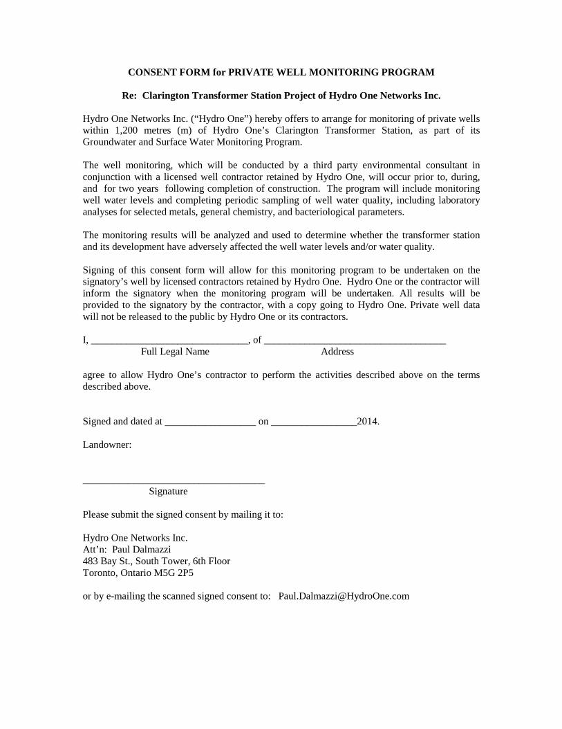
CONSENT FORM for PRIVATE WELL MONITORING PROGRAM
Re: Clarington Transformer Station Project of Hydro One Networks Inc.
Hydro One Networks Inc. (“Hydro One”) hereby offers to arrange for monitoring of private wells within 1,200 metres (m) of Hydro One’s Clarington Transformer Station, as part of its Groundwater and Surface Water Monitoring Program. The well monitoring, which will be conducted by a third party environmental consultant in conjunction with a licensed well contractor retained by Hydro One, will occur prior to, during, and for two years following completion of construction. The program will include monitoring well water levels and completing periodic sampling of well water quality, including laboratory analyses for selected metals, general chemistry, and bacteriological parameters. The monitoring results will be analyzed and used to determine whether the transformer station and its development have adversely affected the well water levels and/or water quality. Signing of this consent form will allow for this monitoring program to be undertaken on the signatory’s well by licensed contractors retained by Hydro One. Hydro One or the contractor will inform the signatory when the monitoring program will be undertaken. All results will be provided to the signatory by the contractor, with a copy going to Hydro One. Private well data will not be released to the public by Hydro One or its contractors. I, _______________________________, of ____________________________________ Full Legal Name Address agree to allow Hydro One’s contractor to perform the activities described above on the terms described above. Signed and dated at __________________ on _________________2014. Landowner: ____________________________________ Signature Please submit the signed consent by mailing it to: Hydro One Networks Inc. Att’n: Paul Dalmazzi 483 Bay St., South Tower, 6th Floor Toronto, Ontario M5G 2P5 or by e-mailing the scanned signed consent to: [email protected]


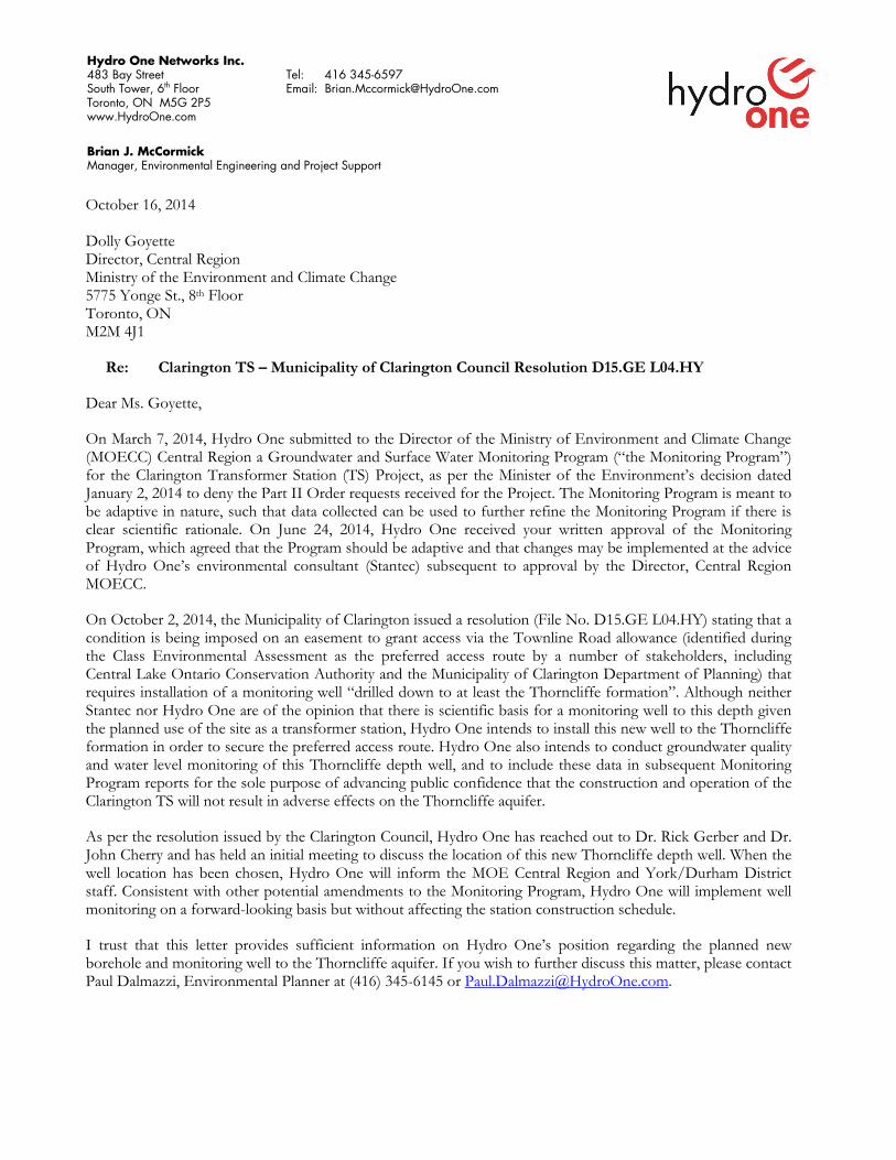
October 16, 2014 Dolly Goyette Director, Central Region Ministry of the Environment and Climate Change 5775 Yonge St., 8th Floor Toronto, ON M2M 4J1
Re: Clarington TS – Municipality of Clarington Council Resolution D15.GE L04.HY
Dear Ms. Goyette,
On March 7, 2014, Hydro One submitted to the Director of the Ministry of Environment and Climate Change (MOECC) Central Region a Groundwater and Surface Water Monitoring Program (“the Monitoring Program”) for the Clarington Transformer Station (TS) Project, as per the Minister of the Environment’s decision dated January 2, 2014 to deny the Part II Order requests received for the Project. The Monitoring Program is meant to be adaptive in nature, such that data collected can be used to further refine the Monitoring Program if there is clear scientific rationale. On June 24, 2014, Hydro One received your written approval of the Monitoring Program, which agreed that the Program should be adaptive and that changes may be implemented at the advice of Hydro One’s environmental consultant (Stantec) subsequent to approval by the Director, Central Region MOECC.
On October 2, 2014, the Municipality of Clarington issued a resolution (File No. D15.GE L04.HY) stating that a condition is being imposed on an easement to grant access via the Townline Road allowance (identified during the Class Environmental Assessment as the preferred access route by a number of stakeholders, including Central Lake Ontario Conservation Authority and the Municipality of Clarington Department of Planning) that requires installation of a monitoring well “drilled down to at least the Thorncliffe formation”. Although neither Stantec nor Hydro One are of the opinion that there is scientific basis for a monitoring well to this depth given the planned use of the site as a transformer station, Hydro One intends to install this new well to the Thorncliffe formation in order to secure the preferred access route. Hydro One also intends to conduct groundwater quality and water level monitoring of this Thorncliffe depth well, and to include these data in subsequent Monitoring Program reports for the sole purpose of advancing public confidence that the construction and operation of the Clarington TS will not result in adverse effects on the Thorncliffe aquifer.
As per the resolution issued by the Clarington Council, Hydro One has reached out to Dr. Rick Gerber and Dr. John Cherry and has held an initial meeting to discuss the location of this new Thorncliffe depth well. When the well location has been chosen, Hydro One will inform the MOE Central Region and York/Durham District staff. Consistent with other potential amendments to the Monitoring Program, Hydro One will implement well monitoring on a forward-looking basis but without affecting the station construction schedule.
I trust that this letter provides sufficient information on Hydro One’s position regarding the planned new borehole and monitoring well to the Thorncliffe aquifer. If you wish to further discuss this matter, please contact Paul Dalmazzi, Environmental Planner at (416) 345-6145 or [email protected].
Hydro One Networks Inc. 483 Bay Street South Tower, 6th Floor Toronto, ON M5G 2P5 www.HydroOne.com
Tel: 416 345-6597 Email: [email protected]
Brian J. McCormick Manager, Environmental Engineering and Project Support
Sincerely,
Brian J. McCormick, Manager Environmental Engineering and Project Support Hydro One Networks CC: Dan Orr, Manager, Technical Support Section, Central Region, MOECC Dave Fumerton, Manager, York/Durham District, MOECC Sandra Thomas, Issues Project Coordinator, York/Durham District, MOECC Brad Bowness, Director, Project Management, Hydro One Networks Denise Jamal, Manager, Public Affairs, Hydro One Networks David Crome, Director, Department of Planning, Municipality of Clarington