Embed Size (px)
Citation preview
Blue Cypress Lk
Sawgrass Lk
Lake
Lk
Hel
en B
laze
s
Indian Riv
Indian Riv
Atlantic Ocean
Atlantic Ocean
SnagHbr
Washburn Cv
Ballard Cv
Indian Riv
Indian Riv
Indian Riv
Indian Riv
Lk Washington
Lk
Wa
shin
gton
Flo
rida E
ast C
oast R
lwy
Flo
rida E
ast
Coast R
lwy
Florid
a E
ast C
oast R
lwy
95
95
95th St
W Nasa Blvd
81st St
89th St
83rd St
Roseland Rd
77th St
141s
t Ave
Post Rd
91st
Ave
89th St
Lake Washington Rd
Fellsmere Rd
Banana River Dr
Harlo
ck R
d
Sheridan Rd
101st St
109th St
5th Ave
Sarno Rd
Aurora Rd
Oak St
W Hibiscus Blvd
Wabasso Beach Rd
Eagles Cir
106t
h Av
e
Jungle Trl
Rollins Blue Cypres Rd
W Eau Gallie Blvd
Atlantic St
S Apollo Blvd
E Strawbridge Ave
N Indian River Dr
Indian River Dr
Parkway Dr
87th St
Crot
on R
d
105th St
111th St
W Eau G
allie Blvd
85th St
Ellis Rd
77th St
Sebastian Blvd
Eau Gallie Cswy
NE Dixie Hwy
Concha Dr
Pineapple Ave
Co R
d 50
7
73rd St
Co Rd
512
66th
Ave
N Wickham
Rd
82nd
Ave
84th
Ave
Blue Cypress Ranch Rd
State Hwy A1A
S Trop ical Trl
Turtle M
ound Rd
88th
Ave
S Harbor City Blvd
58th
Ave
Rivie ra D r NE
Laco
urt L
n
Sand Gulley Dr
Pine
Sap
Ave
L as Pa mos
Dr
Isar Ave NW
Hib iscus Av e
Camilo Cir SW
Fernandina St NW
Micco St SW
Eva
Ln
Buffer Preserve Dr
Malabar Rd NE
Biddle St NE
Spoo
nbil
St E
xd
Mullet Creek Rd
Glen
ham
Dr N
E
Melbourne Tillman Canal No 38
Stallion St
Fossen Dr
Dunc
il Ln
Hoffer A ve NW
Ranc
h Rd
Buckskin St
Oaklyn St NE
Trotters St
Glatter Rd
Sand Point Rd
Trou
t Ave
Flanagan Ave
Deer Run Rd
Hacie
nda
Dr
Hield Rd
Powe
ll
Rd N
W
Pirate Ln
Flam
ms
Pl
Glen
rock
Rd
SW
Sain
t Joh
ns W
ater
Man
agem
ent G
a
Mint
on R
d NE
Laurens Ave
Rheine Rd NW
Ramblebrook St
Malabar Rd NW
Old Dixie Hwy
Wagon Master Trl
Sunswept R
d NE
Granville St NE
Sebastian Canal
Dixie Hwy NE
Grant Rd
Brok
en W
ell L
n
Gillen Ave NW
Kirby
Ave NE
Fox Trail St
River Villa Way
Fell Rd
Berry Rd
Dixie Hwy NE
Wellwood St SW
Hartsdale Ave SW
Tarr
Ave
SW
V alkaria
Rd
Litte
ral L
n
Allis
on Dr
Burto
n Rd
Sea Dunes Dr
Stac
k Bl
vd
Dixie Hwy
Flor
ida
Bird
Vie
wing
Trl
Wye River Rd
Old Mission Rd
Pinto Ln
Brookside St NE
Wils
on
Ln
Centerlane Rd
Malabar Rd NW
Gradick Dr
Agnes
Ave SE
Vally Rd
Edisto
Dr
Darlin g ton Ave SW
Eber Blvd
Cavalier St
Ja Bo
mbar
dier Blvd SW
Trou tman Blvd NE
Judy Kay Rd
Mar
ie S
t
Subs
tatio
n
Rd
Litch
field
Dr
E Florida Ave
Port Malabar Blvd NE
Babc
ock
St
Amad
or A
ve N
W
Hors
esho
e Av
e
Trea
sure
Ln
Woods Trl
Dotti
e Dr
Colorado Ave
Babc
ock
St N
E
W Malabar Rd
Sandy Rd
Flyi
ng U
Ln
Florida Ave W
Willowbrook St
Monaco Rd
Horizon Ln
Macaria Ave
CypressCreek
Dr
Anglers Dr NE
Ba bcoc k St SE
Appaloosa St
Raulerson Ln
Toby
Ave
Web
er R
d
Crepe Myrtle Dr
San Fili ppo
Dr SE
Degroodt Rd SW
Core
y Rd
Edgewood Dr NE
Hield
Rd NW
Lett
Ln
Sarto
ri Av
e
Fairgreen St
Benjamin Rd
Henl
ey
Rd N
W
Celery St
Deau
ville
Ave
Pomello
Rd
Mich
igan
St
Mint
on R
d NE
Quar
term
an
Ln
Davis
Ln
Ray R
d SE
Zaminder St NW
Floridana Ave
Rocky Point Rd
Oakridge Ln
Brab
rook
Ave
Ohio
St
Appleby Ln
Howe
ll
Ln
Henry
Ave
Garbelmann St
Pelican Dr
Glen
cove
Ave
NW
10th St
Nikomas Way
Krefeld Rd NW
Norfolk Pkwy
War
ing
Ln
W Malabar Rd
Hobart
Ave NW
Cattle Dr
Gar d
enwood Cir
Osmosis Dr SE
Mooney Ln
Emerson
Dr NW
Vireo Dr
Long
Poin
t Rd
Foundation
Park Blvd SE
Wingate Blvd
Eldr
on B
lvd
Angora St SW
Micco Rd
Palm Bay Rd NE
Warwick St SE
Buffer Preserve Rd
First St
Farnsworth
Ave
Trea
dwel
l Ln
Fleming Gr ant Rd
Minton Rd
Brookfield St SE
Linrose Ln
Hanson Ave SW
Legh
orn
Rd
Plantation
Cir SE
Here
ford
Ln
Barefoot Cir
Alpi
ne A
ve N
W
Cand
y
Ln
Atz Rd
Beverly Ct
Unde
rhill
Ave
SE
Ponde rosa Rd
Space Coast Hwy
Space Coast Hwy
Kem
pfer
Rd
Bumpy Rd
T M Goodwin Rd
Six Mile C
reek Rd
Ww
Ranc
h Rd
Sim
on R
d
Cypress Lake Dr
Ocea
nPr
airie
Ln
Jon'
s Rd
Dairy Rd
Sweetwater Dr
Arte
rAv
e
W New Haven Ave
Fellsmere RdFellsmere Grade Rd
Kempfer Rd
Mon
roe
St
State Hwy A1A
Space Coast Hwy
Babc
ock
St S
E
Skee
ter L
ake
Rd
Rada
r Rd
H o llywood Blvd
518
518
514
507
514
518
508
500
514
500
500
5
9
5
507
5
513
5
510
5
9
5
1
1
1
1
1
192
1
1
1
1
1
1
192
1
1
1
1
192
192
192
1
192
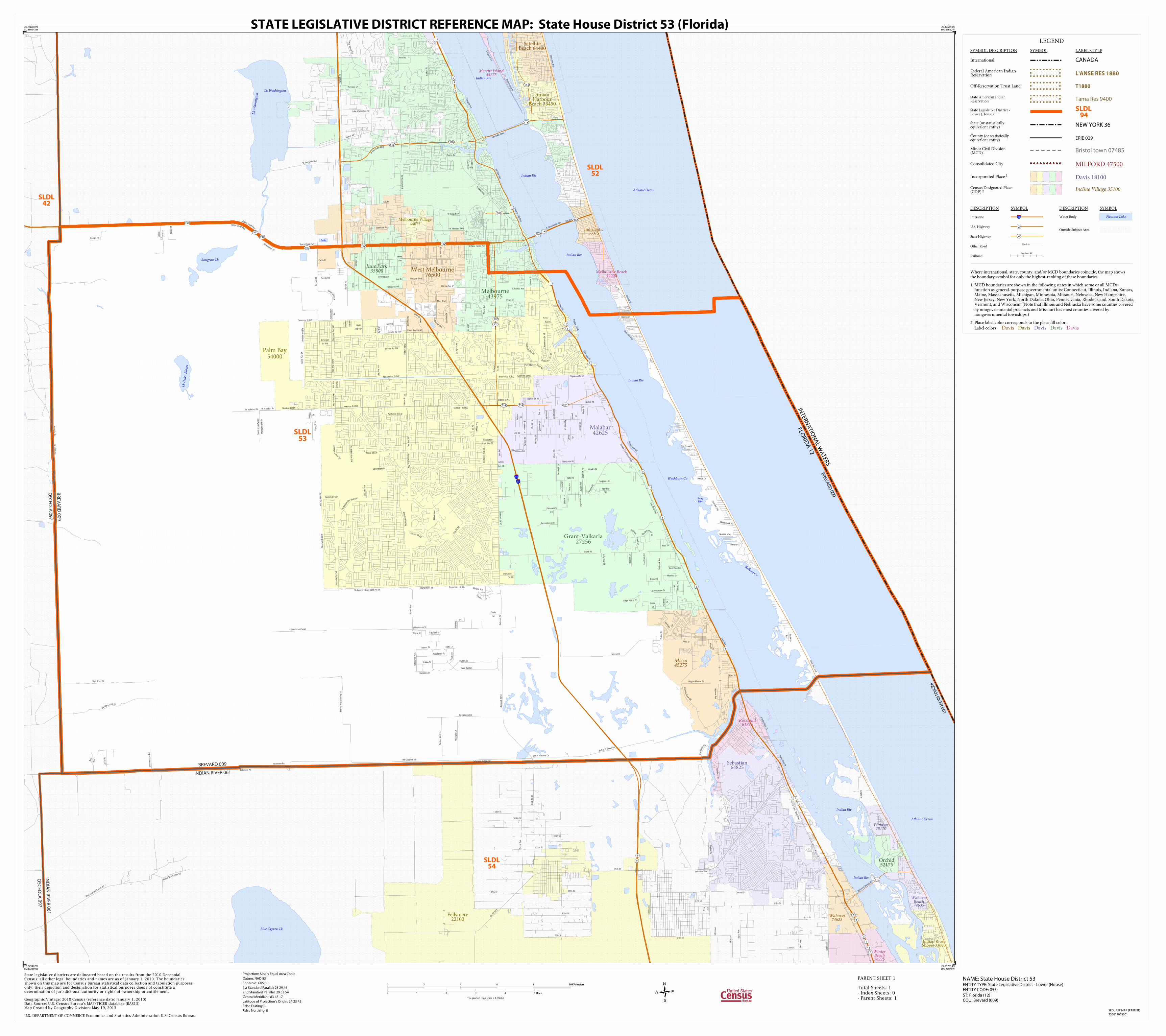
BREVARD 009
INDIAN RIVER 061
BREVA
RD 009
OSC
EOLA
097
BR
EV
AR
D 0
09
IND
IAN
RIVER 061
IND
IAN
RIV
ER
06
1
OS
CE
OLA
09
7
INTERN
ATIO
NA
L WA
TERS
FLORID
A 12
WabassoBeach74635
WinterBeach78225
Merritt Island44275
Wabasso74625
Roseland61875
Windsor78110
Micco45275
June Park35800
Orchid52175
Fellsmere22100
Indian RiverShores 33600
SatelliteBeach 64400
Melbourne Village44075
Sebastian64825
Melbourne Beach44000
Indialantic33375
IndianHarbour
Beach 33450
Malabar42625
West Melbourne76500
Melbourne43975
Palm Bay54000
Grant-Valkaria27256
SLDL42
SLDL52
SLDL54
SLDL53
LEGEND
SYMBOL DESCRIPTION SYMBOL LABEL STYLE
International CANADA
Federal American IndianReservation L'ANSE RES 1880
Off-Reservation Trust Land T1880
State American IndianReservation Tama Res 9400
State Legislative District -Lower (House)
SLDL94
State (or statisticallyequivalent entity) NEW YORK 36
County (or statisticallyequivalent entity) ERIE 029
Minor Civil Division(MCD)1 Bristol town 07485
Consolidated City MILFORD 47500
Incorporated Place 2 Davis 18100
Census Designated Place(CDP) 2 Incline Village 35100
DESCRIPTION SYMBOL DESCRIPTION SYMBOL
Interstate 3
U.S. Highway 2
State Highway 4
Other RoadMarsh Ln
RailroadSouthern RR
Water Body Pleasant Lake
Outside Subject Area
Where international, state, county, and/or MCD boundaries coincide, the map showsthe boundary symbol for only the highest-ranking of these boundaries.
1 MCD boundaries are shown in the following states in which some or all MCDs function as general-purpose governmental units: Connecticut, Illinois, Indiana, Kansas, Maine, Massachusetts, Michigan, Minnesota, Missouri, Nebraska, New Hampshire, New Jersey, New York, North Dakota, Ohio, Pennsylvania, Rhode Island, South Dakota, Vermont, and Wisconsin. (Note that Illinois and Nebraska have some counties covered by nongovernmental precincts and Missouri has most counties covered by nongovernmental townships.)
2 Place label color corresponds to the place fill color.
Label colors: Davis Davis Davis Davis Davis
28.188202N80.880145W
28.176359N80.361662W
27.717614N80.376075W
27.729407N80.892389W
State legislative districts are delineated based on the results from the 2010 DecennialCensus; all other legal boundaries and names are as of January 1, 2010. The boundariesshown on this map are for Census Bureau statistical data collection and tabulation purposesonly; their depiction and designation for statistical purposes does not constitute adetermination of jurisdictional authority or rights of ownership or entitlement.
U.S. DEPARTMENT OF COMMERCE Economics and Statistics Administration U.S. Census Bureau
Geographic Vintage: 2010 Census (reference date: January 1, 2010)Data Source: U.S. Census Bureau's MAF/TIGER database (BAS13)Map Created by Geography Division: May 19, 2013
ENTITY TYPE: State Legislative District - Lower (House)ENTITY CODE: 053
NAME: State House District 53 Projection: Albers Equal Area Conic
Datum: NAD 83
Spheroid: GRS 80
1st Standard Parallel: 25 29 46
2nd Standard Parallel: 29 53 54
Central Meridian: -83 48 17
Latitude of Projection's Origin: 24 23 45
False Easting: 0
False Northing: 0
Total Sheets: 1- Index Sheets: 0- Parent Sheets: 1
ST: Florida (12)COU: Brevard (009)
0 2 4 6 8 10 Kilometers10 Kilometers
0 1 2 3 4 5 Miles5 Miles
The plotted map scale is 1:69694
STATE LEGISLATIVE DISTRICT REFERENCE MAP: State House District 53 (Florida)
SLDL REF MAP (PARENT)
235012053001
PARENT SHEET 1