Embed Size (px)
Citation preview

STATE OF ALASKA
Kei th H. Miller - Governor
DEPARTMENT OF NATURAL RESOURCES
Thomas E . Kel ly - Commissioner
DIVISION OF MINES AND GEOLOGY
James A. Williams - Direc to r
GEOLOGIC REPORT NO. 39
Geology and Geochemistry of t h e Cosmos H i l l s , Ambler River and Shungnak Quadrangles, Alaska
Crawford E. F r i t t s
Col lege , Alaska
September 1970
CONTENTS
Page
ABSTRACT . . . . . . . . . . . . . . . . . . . . . . . . . . . . . . . . . . . 1
. . . . . . . . . . . . . . . . . . . . . . . . . . . . . . . . . INTRODUCTION 2 . . . . . . . . . . . . . . . . . . . . . . . . . . . . P u r p o s e a n d s c o p e 2 Locat ion and Access . . . . . . . . . . . . . . . . . . . . . . . . . . . 2 . . . . . . . . . . . . . . . . . . . . . . . . . . . . . . . F i e l d Work 5 Acknowledgements . . . . . . . . . . . . . . . . . . . . . . . . . . . . 5 Previous Work . . . . . . . . . . . . . . . . . . . . . . . . . . . . . . 6
SURFICIALGEOLOGY . . . . . . . . . . . . . . . . . . . . . . . . . . . . . . 8 . . . . . . . . . . . . . . . . . . . . . . . . . Topography and Drainage 8 . . . . . . . . . . . . . . . . . . . . S u r f i c i a l Depos i t s and G l a c i a t i o n 9
BEDROCKGEOLOGY . . . . . . . . . . . . . . . . . . . . . . . . . . . . . . . 11 I n t e r p r e t a t i o n of S t r a t i g r a p h y and S t r u c t u r e . . . . . . . . . . . . . . 11 St ra t i g r aphy . . . . . . . . . . . . . . . . . . . . . . . . . . . . . . 1 3 . . . . . . . . . . . . . . . . . . . . . . . . . . Pa leozo i cRocks 1 3
PhyZlit ic Schis t and ReZated Rocks (Pzs. Pzc. Pzt. Pzg) . . . . 13 Main DoZomitic Limestone and Related Rocks (Pzd. Pzdp. Pzdg) . . 16 Upper PhyZZite and ReZated Rocks (Pzup. Pzud. Pzug) . . . . . . 20 . . . . . . . . . . . . . . . . . . . . Upper Carbonates (Pzuc) 21 MetabasaZt and Related Rocks (Pzp. Pzv. Pza. PzZ) . . . . . . . 21 . . . . . . . . . . . . . . . . . . . . . . . . . . Cretaceous Rocks 23 MetacongZomerate and Related Rocks (Ks. Kp. k%) . . . . . . . . 23 . . . . . . . . . . . . . . . . . . . . . . . . . . . . . I n t r u s i v e R o c k s 25 . . . . . . . . . . . . . . . . . . . . . . . . . . Cretaceous Rocks 25 . . . . . . . . . . . . . . . . . . . . . . . . . Granite ( K g ) 25 . . . . . . . . . . . . . . . . . . . . . . . . . Quartz Veins 26 . . . . . . . . . . . . . . . . . . . . . . . . . T e r t i a r y ( ? ) Rocks 26 . . . . . . . . . . . . . . . . . . . . . . . Serpent ini te (Ts) 26 . . . . . . . . . . . . . . . . . . . . . . . . . . . . . . . S t r u c t u r e 32 . . . . . . . . . . . . . . . . . . . . . Dome Near Kogoluktuk River 32 . . . . . . . . . . . . . . . . . . . . A n t i c l i n e Near Wesley Creek 32
Horst and Ear ly High-Angle F a u l t s . . . . . . . . . . . . . . . . . 32 Cosmos H i l l s Window and Low-Angle Over thrus t F a u l t s . . . . . . . . 33 La t e High-Angle F a u l t s . . . . . . . . . . . . . . . . . . . . . . . 35 Minor Folds and Crenula t ions . . . . . . . . . . . . . . . . . . . . 35
Metamorphism . . . . . . . . . . . . . . . . . . . . . . . . . . . . . . 35
. . . . . . . . . . . . . . . . . . . . . . . . . . . . . . . GEOLOGICHISTORY 37 Precambrian t o T r i a s s i c Time . . . . . . . . . . . . . . . . . . . . . . 37 J u r a s s i c t o Recent Time . . . . . . . . . . . . . . . . . . . . . . . . . 37
. . . . . . . . . . . . . . . . . . . . . . . . . . . . . . . ECONOMICGEOLOGY 39 Copper . . . . . . . . . . . . . . . . . . . . . . . . . . . . . . . . . 39
S o u r c e s o f D a t a . . . . . . . . . . . . . . . . . . . . . . . . . . 39 Histogy of Explora t ion . . . . . . . . . . . . . . . . . . . . . . . 39 . . . . . . . . . . . . . . . . . . . . Geologic S e t t i n g a t Bo rn i t e 44

CONTENTS
Page
Host Rocks . . . . . . . . . . . . . . . . . . . . . . . . . . . . . . . . . . . . . . . . . Do Zomitization and Ca Zc i t i za t ion VeinZets . . . . . . . . . . . . . . . . . . . ... . . . . . . Be-copper VeinZets . . . . . . . . . . . . . . . . . . . . . Post-copper Ve in le t s . . . . . . . . . . . . . . . . . . . . . Supergene VeinZets . . . . . . . . . . . . . . . . . . . . . . . . . . . . . . . . . . . . . . Shape of Copper Sul f ide Bodies . . . . . . . . . . . . . . . . . . . . . Wa Z Zroc k A Z t erat ion . . . . . . . . . . . . . . . . . . . . . . . . Minerals a t Borni te Sider i t e . . . . . . . . . . . . . . . . . . . . . . . . . . .
. . . . . . . . . . . . . . . . . . . . . . . . . . Pyrrhoti te Cymrite . . . . . . . . . . . . . . . . . . . . . . . . . . . Pyrite . . . . . . . . . . . . . . . . . . . . . . . . . . . . ChaZcopyrite . . . . . . . . . . . . . . . . . . . . . . . . . Bornite . . . . . . . . . . . . . . . . . . . . . . . . . . . Cha Zcocite . . . . . . . . . . . . . . . . . . . . . . . . . .
. . . . . . . . . . . . . . . . . . . Tennanti te-tetrahedrite SphaZerite . . . . . . . . . . . . . . . . . . . . . . . . . . Galena. . . . . . . . . . . . . . . . . . . . . . . . . . . .
. . . . . . . . . . . . . . . . . . . . Other Primary Su l f ides . . . . . . . . . . . . . . . . . . . . . . Supergene Minerals . . . . . . . . . . . . . . . . . . . . . Radioactive Minera Z
AnthaxoZi te . . . . . . . . . . . . . . . . . . . . . . . . . . . . . . . . . . . . . . . . . . . . . . . . PreciousMetazs . . . . . . . . . . . . . . . . . Copper Mine ra l i za t i on a t Borni te Zoning Suggesting Migration of Copper . . . . . . . . . . . . SuZfw Isotopes Suggesting HydrothermaZ A c t i v i t y . . . . . . . Previous Interpretat ions of Origin. Source. and Age of Copper . Present In terpretat ion of Origin. Source. and Age . . . . . .
Reserves . . . . . . . . . . . . . . . . . . . . . . . . . . . . . G o l d . . . . . . . . . . . . . . . . . . . . . . . . . . . . . . . . . . . . . . . . . . . . . . . . . . . . . . . . . . . . T y p e a n d s o u r c e
Shungnak River and V i c i n i t y . . . . . . . . . . . . . . . . . . . . Dahl Creek . . . . . . . . . . . . . . . . . . . . . . . . . . . . C a l i f o r n i a Creek . . . . . . . . . . . . . . . . . . . . . . . . . Lynx Creek . . . . . . . . . . . . . . . . . . . . . . . . . . . . . Ri ley Creek . . . . . . . . . . . . . . . . . . . . . . . . . . . . Other Creeks . . . . . . . . . . . . . . . . . . . . . . . . . . . Reserves . . . . . . . . . . . . . . . . . . . . . . . . . . . . .
Asbestos . . . . . . . . . . . . . . . . . . . . . . . . . . . . . . . . H i s t o r y o f M i n i n g . . . . . . . . . . . . . . . . . . . . . . . . . Deposi ts . . . . . . . . . . . . . . . . . . . . . . . . . . . . . Test ing and P o t e n t i a l . . . . . . . . . . . . . . . . . . . . . . .
Jade . . . . . . . . . . . . . . . . . . . . . . . . . . . . . . . . . . GEOCHEMISTRY . . . . . . . . . . . . . . . . . . . . . . . . . . . . . . . . .
Copper. Lead. and Zinc . . . . . . . . . . . . . . . . . . . . . . . . . Cobalt. Chromium. and Nickel . . . . . . . . . . . . . . . . . . . . . . Antimony . . . . . . . . . . . . . . . . . . . . . . . . . . . . . . . .

CONTENTS
Page
CONCLUSIONS AND GUIDES TO PROSPECTING . . . . . . . . . . . . . . . . . . . . . . 63
. . . . . . . . . . . . . . . . . . . . . . . . . . . . . . . . . . . REFERENCES 65
ILLUSTRATIONS
Figure 1 Map Showing Loca t ion of Cosmos H i l l s and O u t l i n e s of (A) Kobuk . . . . . Trough, (B) Hogatza G e a n t i c l i n e , and (C) Koyukuk Geosyncline 3
S i m p l i f i e d Geologic Map Showing t h e Loca t ions of t h e Cosmos H i l l s Window, S e r p e n t i n i t e i n t h e Jade Mountains, and a Major O v e r t h r u s t F a u l t a long t h e North Edge of Cre taceous S t r a t a . . . . . . 4
Nomenclature and S e l e c t e d Geochemical Sample S i t e s i n Cosmos . . . . . . . . . . . . . . . . . . . . . . . . . . . H i l l s , Alaska pocket
Bedrock Geologic Map of Cosmos H i l l s , Alaska . . . . . . . . . . . . pocke t
Geologic Cross S e c t i o n s t o Accompany F igure 4a . . . . . . . . . . . pocke t
Explana t ion of F i g u r e s 4a and 4b . . . . . . . . . . . . . . . . . . pocke t
Aurora Mountain and Pardners H i l l s Viewed from Cosmos Mountain . , . . 12
White Marble w i t h I n t e r l a y e r e d G r e e n s c h i s t on West Wall of Upper Canyon of Shungnak River n e a r Marble Creek, Cosmos H i l l s . . . . . . . 1 2
. . . . . . . . . F o s s i l s from Dolomit ic L imestone, Pzd , Cosmos H i l l s 18
F o s s i l s from Dolomit ic Limestone, Pzd, Cosmos H i l l s . . . . . . . . . 19
Genera l i zed Geologic Cross S e c t i o n through P a r t of t h e Jade Mountains, N o r t h e a s t e r n Corner of t h e Ambler River A-5 Quadrangle, A l a s k a . . . . . . . . . . . . . . . . , . . . ..........29
Gent ly I n c l i n e d O v e r t h r u s t F a u l t on Northwest Side of Cosmos Mountain . . . . . . . . . . . . . . . . . . . . . . . . . . . . . . . 34
. . . . . . . . . B o r n i t e , Alaska, Viewed from t h e South i n J u l y 1969 40
Genera l ized Geologic Map and Cross S e c t i o n of B o r n i t e Area, Alaska . . 41
L i t h o l o g i e s and Es t imated Volume P e r c e n t a g e s of P y r i t e i n Core from Two Diamond D r i l l Holes a t B o r n i t e , Alaska . . . . . . . . . . . 42
D i s t r i b u t i o n of S u l f i d e s and Other M i n e r a l s i n Core from Two Diamond D r i l l Holes a t B o r n i t e , Alaska . . . . . . . . . . . . . . . . 43

GEOLOGY AND GEOCHEMISTRY OF THE COSMOS HILLS,
AMBLER RIVER AND SHUNGNAK QUADRANGLES, ALASKA
BY
Crawford E. F r i t t s
A B S T R A C T
T h i s r e p o r t summarizes d a t a concern ing topography, g l a c i a t i o n , s t r a t i g r a p h y , s t r u c t u r e , metamorphism, g e o l o g i c h i s t o r y , geochemis t ry , and m i n e r a l s of economic i n t e r e s t i n t h e o l d Shungnak mining d i s t r i c t . The d a t a were c o l l e c t e d d u r i n g d e t a i l e d g e o l o g i c mapping i n 1968 and 1969. The a r e a s t u d i e d i s immediate ly n o r t h of Kobuk i n w e s t e r n A r c t i c Alaska , and i n c l u d e s a n e x p l o r a t i o n camp a t B o r n i t e . Bedrock geology i s emphasized.
S e v e r a l s t r a t i g r a p h i c f o r m a t i o n s r a n g i n g i n age from Devonian t o Cre taceous form a com- p l e x window 20 m i l e s l o n g and 2 t o 8 m i l e s wide, which i s bounded by a t l e a s t f o u r major o v e r t n r u s t f a u l t s . Each of t h e s e f a u l t s is c h a r a c t e r i z e d by a d i s p l a c e m e n t of a t l e a s t s e v e r a l m i l e s . Three p l a t e s of a l l o c h t h o n o u s metamorphosed p e l i t i c , v o l c a n i c , and c a r - b o n a t e s t r a t a , i n c l u d i n g more t h a n 2000 f e e t of f o s s i l i f e r o u s d o l o m i t i c l i m e s t o n e of Middle Devonian a g e , have been t h r u s t over similar metamorphosed p e l i t i c , v o l c a n i c , and s u b o r d i n a t e c a r b o n a t e s t r a t a of p r o b a b l e Devonian age . E a r l y o v e r t h r u s t f a u l t i n g was p receded by emplacement of g r a n i t e of E a r l y Cre taceous a g e , doming and f o l d i n g , p r o g r e s - s i v e r e g i o n a l and the rmal metamorphism of low t o moderate g r a d e , and b l o c k f a u l t i n g . A f o u r t h and uppermost p l a t e of a l l o c h t h o n o u s c l a s t i c r o c k of Cre taceous a g e was t h r u s t over t h e o l d e r s t r a t a i n l a t e s t Cre taceous o r E a r l y T e r t i a r y t i m e . The l a t e s t o v e r t h r u s t f a u l t i n g was accompanied by emplacement and s e r p e n t i n i z a t i o n of i n t r u s i v e u l t r a m a f i c r o c k and by low-grade dynamic o r dynamo-thermal metamorphism of Cre taceous s t r a t a c l o s e t o t h e uppermost t h r u s t . L a t e h igh-ang le f a u l t s of p r o b a b l e T e r t i a r y a g e c u t t h e t h r u s t s a t t h e e a s t e r n end of t h e window.
M i n e r a l s of c u r r e n t economic i n t e r e s t i n c l u d e copper s u l f i d e s and t h e n e p h r i t e v a r i e t y of j a d e , b u t t h e a r e a has produced p l a c e r g o l d and minor a s b e s t o s . Gold m i n e r a l i z a t i o n i s b e l i e v e d t o have p receded copper m i n e r a l i z a t i o n . Gold f o r m e r l y mined from p l a c e r s of T e r t i a r y ( ? ) t o P l e i s t o c e n e a g e was d e r i v e d main ly from a u r i f e r o u s q u a r t z v e i n s t h a t c u t metamorphosed Devonian s t r a t a n e a r i n t r u s i v e g r a n i t e of E a r l y Cre taceous a g e . Copper s u l f i d e s a r e found main ly i n d o l o m i t e b r e c c i a of Middle Devonian a g e c l o s e t o major o v e r r t h r u s t f a u l t s n e a r B o r n i t e . The copper p robab ly i s e p i g e n e t i c i n o r i g i n , b u t o t h e r p o s s i b i l i t i e s a r e d i s c u s s e d b r i e f l y . The main copper d e p o s i t i s b e l i e v e d t o have assumed i ts p r e s e n t form and p o s i t i o n d u r i n g widespread hydro the rmal a c t i v i t y a s s o c i a t e d w i t h s e r p e n t i n i z a t i o n of u l t r a m a f i c r o c k emplaced d u r i n g o v e r t h r u s t f a u l t i n g i n L a t e Cre taceous o r E a r l y T e r t i a r y t ime . The s o u r c e of t h e copper most l i k e l y was s o u t h o r sou thwes t of t h e Cosmos H i l l s . No i n d i s p u t a b l e ev idence h a s been found t o show t h a t copper minera l - i z a t i o n was r e l a t e d t o t h e emplacement of g r a n i t e o r m a f i c r o c k s exposed i n t h i s a r e a . Minor a s b e s t o s i s found i n s e r p e n t i n i t e , and j a d e b o u l d e r s d e r i v e d from t h a t r o c k a r e r ecovered from o l d p l a c e r t a i l i n g s .

I N T R O D U C T I O N
PURPOSE AND SCOPE
The Cosmos H i l l s i n w e s t e r n A r c t i c Alaska a r e g e o l o g i c a l l y un ique f o r t h r e e main r e a s o n s .
(1 ) They a r e t h e s i t e of t h e o n l y major a n t i c l i n a l s t r u c t u r e now known t o be a window on t h e n o r t h edge of t h e Kobuk t r o u g h , which i s one of seven g e o s y n c l i n e s i n Alaska c o n t a i n i n g Cre taceous s t r a t a .
(2) At B o r n i t e , P a l e o z o i c s t r a t a i n s i d e t h e Cosmos H i l l s window c o n t a i n t h e l a r g e s t r e c e n t l y p u b l i c i z e d s t r a t i f o r m copper d e p o s i t i n t h e S t a t e .
(3) These h i l l s c o n s t i t u t e most of t h e o l d Shungnak mining d i s t r i c t , which c o n t a i n s abandoned g o l d p l a c e r s and a s b e s t o s p r o s p e c t s a s w e l l a s a c t i v e j a d e c l a i m s . The v a r i e t y of m i n e r a l s of economic i n t e r e s t i s b u t a s m a l l e x p r e s s i o n of t h e g e o l o g i c a l complex i ty of t h e a r e a .
I n 1968, t h e Alaska D i v i s i o n of Mines and Geology began a 2-year s t u d y of t h e Cosmos H i l l s i n o r d e r t o de te rmine t h e r e l a t i o n s h i p between r e g i o n a l geology and m i n e r a l d e p o s i t s of economic i n t e r e s t i n t h e Shungnak mining d i s t r i c t . S p e c i a l a t t e n t i o n was g i v e n t o s t r a - t i g r a p h y , s t r u c t u r e , igneous a c t i v i t y , metamorphism, and g e o l o g i c h i s t o r y , because i n f o r - mat ion a b o u t them can b e of l o n g r a n g e v a l u e i n e x p l o r a t i o n f o r l o d e d e p o s i t s . Topography, d r a i n a g e , and g l a c i a t i o n a l s o were s t u d i e d , because t h e y p r o v i d e i m p o r t a n t c l u e s concern- i n g t h e g e o l o g i c h i s t o r y of t h e a r e a and t h e d e p o s i t i o n of p l a c e r d e p o s i t s .
T h i s r e p o r t d e s c r i b e s t h e r e s u l t s of bedrock mapping and s t ream-sediment sampl ing i n t h e Cosmos H i l l s d u r i n g t h e summers of 1968 and 1969. It supplements ADMG Geolog ic Repor t 37 ( F r i t t s , 1 9 6 9 ) , which p r i m a r i l y concerns work done by t h e D i v i s i o n i n t h e sou th - e a s t e r n p a r t of t h e Cosmos H i l l s i n 1968. Some of t h e d a t a p r e s e n t e d i n t h a t r e p o r t a r e n e c e s s a r i l y modi f i ed h e r e i n t h e l i g h t of new i n f o r m a t i o n o b t a i n e d i n 1969. Othe r s a r e r e p e a t e d f o r t h e s a k e of thoroughness , b u t pho tographs and t a b u l a t e d geochemical d a t a a r e n o t . By add ing t a b l e 1 of Repor t 37 t o t h e p r e s e n t r e p o r t , t h e r e a d e r w i l l have a s i n g l e r e a s o n a b l y complete summary of t h e geology and geochemis t ry of t h e Shungnak mining d i s t r i c t based on d a t a a v a i l a b l e up t o J u n e 1970.
LOCATION AND ACCESS
The Cosmos H i l l s form a n i s o l a t e d h i g h l a n d 1 0 x 27 m i l e s a l o n g t h e s o u t h e r n f l a n k of t h e Brooks Range abou t 300 m i l e s nor thwes t of F a i r b a n k s ( f ig 1) . The h i g h l a n d e x t e n d s e a s t s o u t h e a s t a c r o s s t h e boundary between t h e Ambler R ive r and Shungnak q u a d r a n g l e s ( f ig 2 ) . The Cosmos H i l l s a r e s o u t h of t h e Schwatka Mountains, e a s t s o u t h e a s t of t h e J a d e Moun- t a i n s and wes t n o r t h w e s t of t h e Angayucham Mountains , The Cosmos H i l l s a r e approx imate ly 4 m i l e s n o r t h of t h e v i l l a g e of Kobuk. Th i s v i l l a g e now c o n t a i n s a b o u t 50 r e s i d e n t s , b u t f o r m e r l y was much l a r g e r , For many y e a r s i t was known a s Shungnak, and was t h e main s h i p - p i n g and s u p p l y p o i n t f o r t h e Shungnak mining d i s t r i c t , The s i t e , however, commonly i s f l o o d e d d u r i n g s p r i n g breakup. I n t h e l a t e 1 9 2 0 ' s many r e s i d e n t s l e f t , and t h e v i l l a g e became known a s Long Beach u n t i l a t l e a s t 1931. The Kobuk p o s t o f f i c e , e s t a b l i s h e d i n 1928, now i s l o c a t e d h e r e . The p r e s e n t v i l l a g e of Shungnak, which c o n t a i n s approx imate ly 150 r e s i d e n t s , is a b o u t 7 m i l e s wes t of Kobuk. B o r n i t e , t h e e x p l o r a t i o n camp of Bear Creek 14ining Company and t h e Kennecot t Copper C o r p o r a t i o n , is a b o u t 11 m i l e s n o r t h of Kobuk,


Access t o t h e mapped a r e a i s mainly by a i r , b u t p a r t l y by road and w a t e r . Grave l l a n d i n g s t r i p s have been b u i l t a t Dahl Creek, Kobuk, Shungnak, and B o r n i t e , A good g r a v e l road e x t e n d s from B o r n i t e t o Dahl Creek and t o t h e mining companies ' Kobuk River Landing ( f i g 3 ) . A poore r road e x t e n d s from Dahl Creek t o Kobuk, which i s t h e e a s t e r n m o s t p o i n t r eached by t u g b o a t s and b a r g e s on t h e Kobuk River . Cat t r a i l s o r unimproved r o a d s l e a d t o o l d p l a c e r workings and p r o s p e c t s n e a r Dahl , C a l i f o r n i a , and Cosmos Creeks , t h e Shungnak R i v e r , and P a r d n e r s H i l l , b u t most a r e i n poor c o n d i t i o n . The e a s t e r n p a r t of t h e a r e a can be reached by canoe v i a t h e Kobuk and Kogoluktuk R i v e r s and by f l o a t p l a n e v i a Kol l ioksalc Lake and t h e Kogoluktuk when r i v e r l e v e l s a r e h i g h . The w e s t e r n p a r t of t h e a r e a , however, i s a c c e s s i b l e ma in ly on f o o t o r by h e l i c o p t e r . The Shungnak River i s t o o s h a l l o w f o r f l o a t p l a n e s and too s w i f t i n deep canyons f o r canoes . The upper canyon ( f i g 3 ) , f o r example, i s c h a r a c t e r i z e d by n e a r l y v e r t i c a l w a l l s 100 t o 200 f e e t h i g h and a r o a r i n g c h u t e of unnav igab le w h i t e w a t e r .
FIELD WORK
F i e l d work was done on f o o t from f o u r main camps on Dahl Creek and t h e Kogoluktuk and Shungnak Kivers ( f i g 3 ) . Camps 1 and 2 were occupied i n 1968. Br ie f r e c o n n a i s s a n c e wes t of K o l l i o k s a k Lake was accomplished a t t h a t t ime v i a f l o a t p l a n e . Camps 1, 3 , and 4 were occup ied i n 1969. Mapping t h e n was f a c i l i t a t e d by u s e of a Honda T r a i l - 9 0 motor- b i k e a l o n g t h e road from Dahl Creek t o B o r n i t e and on t r a i l s l e a d i n g t o P a r d n e r s H i l l and t h e upper Dahl Creek p l a c e r s . Camps 2 and 3 were reached by canoe and f l o a t p l a n e , r e s p e c t i v e l y . Moves from Camp 3 t o Camp 4 and t h e n t o Kobuk were accomplished by h e l i - c o p t e r , c o u r t e s y of Bekr Creek Mining Company. Mapping i n 1968 was done on p u b l i s h e d t o p o g r a p h i c b a s e maps a t s c a l e 1 :63 ,360 ( 1 i n c h = I m i l e ) . Mapping i n 1969 and a l l c o m p i l a t i o n s were done on s c r i b e c o a t topograph ic b a s e maps a t s c a l e 1 :48 ,000 ( 1 i n c h =
4000 f e e t ) . The f i n a l map was r e d r a f t e d f o r p u b l i c a t i o n a t a reduced s c a l e .
ACKNOWLEDGEYENTS
Numerous peop le f a c i l i t a t e d t h e r e c e n t work, C h r i s t o p h e r P . Cameron and Samuel W . Corbin were g e o l o g i c a l f i e l d a s s i s t a n t s r e s p o n s i b l e f o r a l l geochemical sampl ing i n 1968 and 1969, r e s p e c t i v e l y . They a l s o d i d some of t h e g e o l o g i c mapping. We a r e e s p e c i a l l y g r a t e f u l t o Bear Creek Mining Company, Kennecot t Copper C o r p o r a t i o n , Bernhard t A i r S e r v i c e , Wien Conso l ida ted A i r L i n e s , and r e s i d e n t s of Kobuk and Dahl Creek f o r c o u r t e s i e s and a s s i s t a n c e d u r i n g b o t h f i e l d s e a s o n s . I n d i v i d u a l s who d e s e r v e s p e c i a l ment ion i n c l u d e ; D. M. Snyder , C . G . Bigelow, R ichard W a l t e r s , and K e i t h Marple of Bear Creek Mining Company, A. A. Dundas and P a u l Mogenson of Kennecot t Copper C o r p o r a t i o n ; Mr. and Mrs. Anthony B e r n h a r d t , M r . and Mrs. Guy Moyer, and Michael T i c k e t t of Kobuk; and M r . and M r s . James E d s a l l , W i l l i a m Munz, Ivan S t e w a r t , and C . E . S t o u t o f Dahl Creek. Bigelow, g e o l o g i s t - i n - c h a r g e a t B o r n i t e , showed c o n t i n u a l i n t e r e s t i n o u r work, engaged i n s e v e r a l t e c h n i c a l d i s c u s s i o n s w i t h t h e w r i t e r , and a r r a n g e d f o r b r i e f h e l i c o p t e r s u p p o r t i n 1969.
Members of t h e U . S. G e o l o g i c a l Survey a l s o have been h e l p f u l . I. L. T a i l l e u r , W . P . Brosge, W. W. P a t t o n , J r . , R. B , Forbes , C . L. S a i n s b u r y and o t h e r s have d i s c u s s e d v a r i - o u s a s p e c t s of t h e geology of t h e Brooks Range and Seward P e n i n s u l a . T a i l l e u r a l s o loaned t h e w r i t e r p r e l i m i n a r y maps and o t h e r d a t a accumulated d u r i n g g e o l o g i c a l recon- n a i s s a n c e i n and n e a r t h e Cosmos H i l l s . J . T, Dut ro , J r , , and J . W . Huddle s t u d i e d c r i n o i d - b e a r i n g l i m e s t o n e c o l l e c t e d by t h e w r i t e r a t Ferguson Peak i n 1968. Dutro a l s o s t u d i e d o t h e r f o s s i l s c o l l e c t e d by t h e w r i t e r i n t h e Ambler R i v e r quadrang le i n 1969. Geochemical samples c o l l e c t e d i n 1968 were ana lyzed a t a USGS f i e l d l a b o r a t o r y i n Anchorage.
A s s i s t a n c e and s u g g e s t i o n s by c o l l e a g u e s i n t h e Alaska D i v i s i o n of Mines and Geology a l s o a r e a p p r e c i a t e d . The w r i t e r h a s b e n e f i t e d from numerous d i s c u s s i o n s o f t h e g e o l g y of t h e Brooks Range and Seward P e n i n s u l a w i t h E. R . Chipp and Gordon H e r r e i d , r e s p e c t i v e l y . Atomic a b s o r p t i o n and X-ray a n a l y s e s of samples c o l l e c t e d i n 1969 were done by Namok Cho and Michael M i t c h e l l i n t h e D i v i s i o n l a b o r a t o r y a t C o l l e g e . Hand samples were photo- graphed by G. R . Eak ins . F i n a l d r a f t i n g was done by C h a r l o t t e Renaud.
The M i n e r a l s I n d u s t r i e s Research Labora to ry a t t h e U n i v e r s i t y of Alaska performed 30-element s p e c t r o g r a p h i c a n a l y s e s of s t r e a m sediment samples c o l l e c t e d i n 1969. A computer program was d e v i s e d by Lawrence E. He ine r t o h a n d l e such d a t a .
PREVIOUS WORK
E x p l o r a t i o n , p r o s p e c t i n g , min ing , and g e o l o g i c a l r e c o n n a i s s a n c e i n and n e a r t h e Cosmos H i l l s have been mentioned i n more t h a n 60 r e p o r t s s i n c e 1884. However, many r e f e r e n c e s a r e b r i e f , and a t l e a s t 1 5 a r e unpub l i shed , The a v a i l a b l e l i t e r a t u r e h a s been summarized by t h e w r i t e r i n a n n o t a t e d b i b l i o g r a p h i e s concern ing (1) copper , (2) g o l d , and (3) s e r - p e n t i n i t e , a s b e s t o s , and j a d e , They a r e f i l e d a t t h e o f f i c e o f t h e D i v i s i o n of Mines and Geology i n Co l l ege . The more i m p o r t a n t r e f e r e n c e s were d i s c u s s e d i n ADMG Geo log ic Repor t 37 , These and o t h e r s a r e c a t e g o r i z e d below.
E x p l o r a t i o n i n 1884-1886 by t h e U . S. Navy a l o n g t h e Kobuk ( fo rmer ly Kowuk o r Kowak) Rive r was d i s c u s s e d by Cantwel l (1884, 1885) and Stoney (1900) . No g e o l o g i c a l work was done, b u t t h e a u t h o r s d e s c r i b e d t r i p s t o t h e J a d e Mountains abou t 20 m i l e s wes t nor thwes t of t h e Cosmos H i l l s , i n s e a r c h of j a d e (fig 2 ) . Samples were d e s c r i b e d by M e r r i l l (1885) and C l a r k e and M e r r i l l (1888).
The go ld r u s h of 1898 brought hundreds of p r o s p e c t o r s t o t h e Kobuk R i v e r r e g i o n , approx i - ma te ly 800 of whom e s t a b l i s h e d w i n t e r camps a long t h e r i v e r . The a c t i v i t i e s and f r u s t r a - t i o n s of one group of 20 Inen from San Pedro , C a l i f o r n i a , were r ecorded by G r i n n e l l (1901) , T h i s group e s t a b l i s h e d two w i n t e r camps. One was on t h e Kobuk n e a r t h e mouth of t h e Hunt R i v e r . The o t h e r was on t h e Kogoluktuk Kiver i n t h e Cosmos H i l l s , L i k e most o t h e r pros- p e c t o r s i n t h e r e g i o n , however, t h e group l e f t f o r home by way of Nome i n t h e s p r i n g of 1899.
Work by t h e U, S. G e o l o g i c a l Survey i n t h e Cosmos H i l l s h a s i n c l u d e d g e o l o g i c a l recon- n a i s s a n c e , t h e p r e p a r a t i o n of b r i e f p r o g r e s s r e p o r t s on p l a c e r go ld p r o d u c t i o n , and s h o r t i n v e s t i g a t i o n s of o t h e r m i n e r a l d e p o s i t s . I n i t i a l r e c o n n a i s s a n c e was under taken by Mendenhall (1902) , who descended t h e Kobuk River by canoe i n August 1901. The b e s t e a r l y d e s c r i p t i o n of t h e g e n e r a l geology and p l a c e r s of t h e a r e a was p repared by Smith and Eakin (1911). These a u t h o r s named t h e Cosmos H i l l s f o r F o r t Cosmos, a w i n t e r camp e s t a b - l i s h e d by Stoney i n 1885 n e a r t h e mouth of t h e p r e s e n t Cosmos Creek. Smith (1913) and Smith and M e r t i e (1930) r e p e a t e d a lmos t v e r b a t i m much of t h e d a t a r e c o r d e d by Smith and Eakin . S t a t i s t i c a l d a t a concern ing p l a c e r mining and g o l d p r o d u c t i o n were recorded by Brooks (1905, 1 9 0 6 ) , Brooks and o t h e r s (1909, 1910, 1912, 1913, 1914, 1916, 1921, 1922, 1924, 1 9 2 5 ) , M a r t i n and o t h e r s (1919) , C a t h c a r t (1920) , M o f f i t t and o t h e r s (1927) , Smith and o t h e r s (1929, 1930a, 1930b, 1932, 1933) , and Smith (1933, 1934a, 1934b, 1936, 1937, 1938, 1939a, 1939b, 1941, 1942) . Asbes tos -bea r ing s e r p e n t i n i t e a t Asbes tos Mountain was mapped and d e s c r i b e d by Coats (1943) . E a r l y copper p r o s p e c t s n e a r B o r n i t e were d e s c r i b e d by Brooks and o t h e r s (1909) and Smith and Eakin (1911) . Uranium m i n e r a l i z a t i o n t h e r e was d i s c u s s e d by White (1950) , Wedow (1956) , and Matzko and Freeman (1963) . S u r f i c i a l geol- ogy was mapped and d e s c r i b e d by F e r n a l d (1964) . Data concern ing m e t a l l i c m i n e r a l r e - s o u r c e s were summarized by Berg and Cobb (1967) and Cobb (1968a, 1968b) , Modern recon- n a i s s a n c e g e o l o g i c mapping a t s c a l e 1 :250 ,000 ( 1 i n c h = 4 m i l e s ) was done by P a t t o n , M i l l e r , and T a i l l e u r (1968) , who a l s o recorded t h e l a t e s t p a l e o n t o l o g i c a l and r a d i o m e t r i c d a t a concern ing t h e a g e s of r o c k s i n and n e a r t h e Cosmos H i l l s . T h e i r map h a s been e s p e c i a l l y u s e f u l i n p l a n n i n g subsequen t d e t a i l e d g e o l o g i c mapping.

The U. S . Bureau of Mines sampled a s b e s t o s - b e a r i n g s e r p e n t i n i t e a e a r Bismark Mountain i n 1944 and n e a r Shungnak and Asbes tos Mountains i n 1945 and 1946, P r e l i m i n a r y work was reviewed by t h e U. S. Bureau of Mines (1944) and Bain (1946) . The g e n e r a l g e o l o g i c s e t t i n g of t h e a s b e s t o s d e p o s i t s and t h e methods and r e s u l t s of sampl ing were d e s c r i b e d by Heide, Wright , and Rut l edge (1949) , who p u b l i s h e d t h e map of Asbes tos Mountain p re - pared by Coa t s (1943) .
Work by t h e Alaska T e r r i t o r i a l Department of Mines i n v o l v e d main ly examina t ions and d e s c r i p t i o n s of c e r t a i n m i n e r a l d e p o s i t s , p r o s p e c t s , and mining o p e r a t i o n s . Wimmler (1925) mentioned p l a c e r mining i n t h e Shungnak d i s t r i c t i n 1925. Reed (1932) p r e p a r e d a much more complete summary of go ld p l a c e r s , mining, and p r o s p e c t i n g i n t h e Cosmos H i l l s a s of 1931. Anderson (1945, 1947) b r i e f l y d e s c r i b e d c o p p e r , j a d e , and a s b e s t o s d e p o s i t s i n t h i s a r e a and i n t h e J a d e Mountains . Saunders (1953, 1955, 1956, 1963) examined copper p r o s p e c t s a t Ruby Creek and P a r d n e r s H i l l , and no ted t h a t " j ade" boul- d e r s were be ing recovered from Dahl Creek a s e a r l y a s 1952.
Bear Creek Mining Company, a s u b s i d i a r y of Kennecot t Copper C o r p o r a t i o n , began d e t a i l e d e x p l o r a t i o n f o r copper n e a r Ruby Creek ( B o r n i t e ) and P a r d n e r s H i l l i n 1957 a f t e r s e v e r - a l y e a r s of p r o s p e c t i n g had been done by R h i n e h a r t Berg and h i s a s s o c i a t e s . The r e c e n t work h a s i n c l u d e d s i t e mapping, t r e n c h i n g , d i a m o n d - d r i l l i n g , geochemical sampl ing , geo- p h y s i c a l s u r v e y i n g , and l i m i t e d underground e x p l o r a t i o n . Bear Creek a l s o engaged i n r e g i o n a l e x p l o r a t i o n and r e c o n n a i s s a n c e mapping, Read and Lehner (1959) mapped t h e bed- r o c k geology of t h e Cosmos H i l l s a t s c a l e 1 :125,000 ( 1 i n c h = 2 m i l e s ) . The g e n e r a l g e o l o g i c s e t t i n g and v a r i o u s a s p e c t s of m i n e r a l i z a t i o n and e x p l o r a t i o n a t B o r n i t e were d i s c u s s e d by Chadwick (1960) , Lund (1961) , Lutz (1963) , and R u n n e l l s (1963, 1964 , 1965, 1966, 1 9 6 9 ) , D e t a i l e d s t r a t i g r a p h i c s t u d i e s by C , G, Bigelow were acknowledged by Runne l l s (1963, p 27), b u t remain l a r g e l y c o n f i d e n t i a l . The r e p o r t by Read and Lehner (1959) a l s o i s c o n f i d e n t i a l and h a s n o t been r e a d by t h e p r e s e n t w r i t e r ,
D e t a i l e d g e o l o g i c mapping and geochemical sampl ing by t h e Alaska D i v i s i o n of Mines and Geology i n t h e s o u t h e a s t e r n p a r t of t h e Cosmos H i l l s were d i s c u s s e d by F r i t t s (1969) . The a u t h o r mapped and d e s c r i b e d f o u r main s t r a t i g r a p h i c f o r m a t i o n s r a n g i n g i n age from N i d d l e Devonian o r o l d e r t o L a t e C r e t a c e o u s . He a c c e p t e d most of t h e g e o l o g i c a g e s a s s i g n e d t o t h o s e r o c k s by P a t t o n , M i l l e r , and T a i l l e u r (1968) , b u t showed t h a t a u n i t of m e t a b a s a l t and r e l a t e d r o c k s above Middle Devonian d o l o m i t i c l i m e s t o n e p robab ly i s Devonian r a t h e r t h a n J u r a s s i c ( ? ) i n a g e , He a l s o showed t h a t g e o l o g i c s t r u c t u r e and g e o l o g i c h i s t o r y i n t h e a r e a a r e more complex t h a n p r e v i o u s l y supposed. R e i n t e r p r e t i n g some of t h e d a t a r ecorded by p r e v i o u s a u t h o r s , h e concluded t h a t t h e p r i n c i p a l g e o l o g i c s t r u c t u r e i n t h e Cosmos H i l l s i s a window bounded by two major low-angle o v e r t h r u s t f a u l t s r a t h e r t h a n a doubly-plunging a n t i c l i n e bounded by two major u n c o n f o r m i t i e s . Geochemical d a t a showed t h a t copper m i n e r a l i z a t i o n p robab ly d i d n o t accompany emplace- ment of g r a n i t e of E a r l y Cre taceous age i n t h i s a r e a . The a u t h o r t e n t a t i v e l y a c c e p t e d t h e J u r a s s i c ( ? ) a g e p r e v i o u s l y a s s i g n e d t o l o c a l s e r p e n t i n i t e by P a t t o n , M i l l e r , and T a i l l e u r (1968) b u t added a n o t e t o t h e map e x p l a n a t i o n i n d i c a t i n g t h a t a L a t e Cre taceous o r younger age i s r e q u i r e d by f i e l d e v i d e n c e found i n t h e Ambler R i v e r q u a d r a n g l e i n 1969. F i e l d e v i d e n c e found a t t h a t t i m e a l s o showed t h a t g e o l o g i c s t r u c t u r e i n t h e a r e a is even more complex t h a n r e a l i z e d i n 1968,
The a u t h o r would l i k e t o c o r r e c t t h e f o l l o w i n g omiss ions from Geolag ic R ~ p o r t 37:
Tab le 1 (1) F o o t n o t e s were t o have been numbered t o s p e c i f i c a l l y acknowledge M i l l e r and T ~ i p p f o r a tomic a b s o r p t i o n anal-yses , al:d Curly and Mar t inez f o r s p e c t r o g r a p h i c a n a l y s e s .
F i g u r e 2a (1 ) C i r c l e s shown a t S t o u t Mountain and Ferguson Peak were t o have c o n t a i n e d t h e i e t t e r I! t o d e s i g n a t e f o s s i l localities. The e n t i r e symbol was o m i t t e d trom t h e map e x p l a n a t i o n ,
( 2 ) Near J u a n i t a Creek, s e c . 23, T . 18 N., 'J. 1 0 E., l a b e l s were o m i t t e d from a s m a l l body of s e r p e n t i n i t e ( .Is) a d j z c e n t t o an o v e r t h r u s t f a l l l t , and from a l i m e s t o n e (Pzc) n o r t b of t h e fatlLt.
(3 ) Near G l a c i e r Creek, s e e , 7 , T, 18 N . , R . 1 0 C , , ?ahel-s w e r p o m i t t e d from s m a l l b o d i e s o f l i m e s t o n e (Pzc) and ere ' 6 : n u t u n e (Pzg) in t h e s o u t h w e s t e r n and n o r t h w e s t e r n p d r t s of t h e sec t i c -n , r e s p e c t j v e l y ,
( 4 ) Near Lynx and C a l i f o r n i a Creeks , s e c s . 1 6 a ~ l d >2. T. ! R M , R , 1 0 E , , l a b e l s were o m i t t e d from s m a l l b o d i e s of 1 imc j tone (I 'w),
S U R F I C I A L G E O L O G Y
TOPOGRAPHY AND DRAINAGE
The Cosmos H i l l s a r e c h a r a c t e r i z e d by modera te ly rugged m a t u r e topography and approx i - m a t e l y 3000 f e e t of r e l i e f . Ine revuk Mountain, t h e t a l l e s t peak, i s 3440 f e e t h i g h , T h i s mountain and s e v e r a l o t h e r s t h a t exceed 2600 f e e t a l o n g tile w e s t e r n , sou t l l e rn , and e a s t e r n edges of t h e main h i g h l a n d a r e u n d e r l a i n by c o n t i n e n t a l s t r a t a of Cre taceous a g e , which h e l p f rame t h e Cosmos H i l l s window. I n s i d e t h i s semi-rim, most h i l l s cons i s : ma in ly of mar ine s t r a t a of P a l e o z o i c age and do n o t exceed 2440 f e e t , However, Black Rock Ridge, which i s capped by r e s i s t a n t g r e e n s t o n e , r e a c h e s 2960 f e e t , Xn c o n t r a s t , t h e e l e v a t i o n s of Camps 1 t o 4 r a n g e from 250 t o abou t 500 f e e t ,
Major r i v e r s i n t h e Cosmos H i l l s and Angayucham Mountains and i n t h e a d j a c e n t Schwatka Mountains of t h e Brooks Range a l l f l o w south-southwestward away from b u t n e a r l y perpen- d i c u l a r t o t h e r a n g e . Dra inage i n t h e map a r e a i s p r i m a r i l y south-southwestward v i a t h e Shungnak and Kogoluktuk R i v e r s , a l t h o u g h s e v e r a l s t r e a m s such a s Ruby Creek f l o w n o r t h - ward b e f o r e j o i n i n g t h e s e r i v e r s . A l l of t h e major r i v e r v a l l e y s a r e r e l a t i v e l y s t r a i g h t where they p a s s through mountainous t e r r a i n , and t h o s e of t h e Cosmos H i l l s a r e i n l i n e w i t h c o u n t e r p a r t s i n t h e Schwatka Mountains . A f t e r l e a v i n g t h o s e mounta ins , however, s e v e r a l r ivers swing westward 5 t o 15 m i l e s th rough t h e west -plunging Ambler Lowland b e f o r e p a s s i n g th rough t h e Cosmos H i l l s and e q u i v a l e n t h i g h l a n d s (fig 2 ) . T h i s change i n c o u r s e i s b e l i e v e d t o b e due p r i m a r i l y t o s l i g h t u p l i f t of t h e Cosmos H i l l s and Angayucham Mountains r e l a t i v e t o t h e Schwatka Mountains o f t h e Brooks Range i n T e r t i a r y

o r Qua te rna ry t ime . The l o c a l d r a i n a g e a l s o i s i n f l u e n c e d t o some e x t e n t by t h e p r e s e n c e of g l a c i a l d r i f t of P l e i s t o c e n e age ( S u r f i c i a l d e p o s i t s and g l a c i a t i o n ) . The phys io - g r a p h i c ev idence a t hand s u g g e s t s t h a t t h e v a l l e y s now occupied by t h e Shungnak and Kogoluktuk R i v e r s and K o l l i o k s a k Lake i n t h e Cosmos H i l l s f o r m e r l y were occupied by t h e Ambler, Shungnak, and Kogoluktuk R i v e r s , r e s p e c t i v e l y .
The s t r a i g h t n e s s of t h e major r i v e r v a l l e y s and t h e i r r e l a t i o n s h i p t o t h e t r e n d of t h e Schwatka Mountains of t h e p r e s e n t Brooks Range c l e a r l y i n d i c a t e t h a t they a r e a n t e c e d e n t v a l l e y s formed d u r i n g a p r e - g l a c i a l e p i s o d e of e r o s i o n . T h e i r sou th - sou thwes t t r e n d s r e f l e c t o r i g i n a l consequent d r a i n a g e d i r e c t l y r e l a t e d t o t h e u p l i f t of t h e a n c e s t r a l Brooks Range, which p robab ly resembled t h e p r e s e n t Alaska Range i n a l t i t u d e and r e l i e f d u r i n g much of Cre taceous t ime ( S t r u c t u r e and g e o l o g i c h i s t o r y ) . The v a l l e y s now occu- p i e d by Cosmos Creek and by Wesley and Ruby Creeks a r e p a r a l l e l t o a d j a c e n t ma jo r r i v e r v a l l e y s , The c r e e k v a l l e y s , however, seem o v e r s i z e f o r t h e s t r e a m s t h a t now occupy them. They most l i k e l y were s t a r t e d by s t r e a m s of t h e o r i g i n a l consequent d r a i n a g e sys tem of t h e a n c e s t r a l Brooks Range b e f o r e t h e Cosmos H i l l s were i s o l a t e d from t h e Schwatka Moun- t a i n s by e r o s i o n ,
Downcutting by t h e major r i v e r s presumably h a s been contemporaneous w i t h i n t e r m i t t e n t r e g i o n a l de fo rmat ion s i n c e l a t e s t J u r a s s i c o r e a r l i e s t C r e t a c e o u s t ime . The o r i g i n a l consequent d r a i n a g e sys tem probab ly began w i t h i n i t i a l e l e v a t i o n of t h e Brooks Range g e a n t i c l i n e i n L a t e J u r a s s i c t ime (Payne, 1955) . I n t h e Cosmos H i l l s , o r o g e n i c a c t i v i t y r eached a c l imax d u r i n g E a r l y t o L a t e Cre taceous t ime , when e x t e n s i v e o v e r t h r u s t f a u l t - i n g accompanied(?) o r fo l lowed t h e emplacement of g r a n i t e now b e l i e v e d t o be abou t 120 m i l l i o n y e a r s o l d ( G r a n i t e and s t r u c t u r e ) , Renewed o r o g e n i c a c t i v i t y d u r i n g l a t e s t Cre taceous o r E a r l y T e r t i a r y t i m e pe rhaps 50 t o 70 m i l l i o n y e a r s ago i n v o l v e d o v e r t h r u s t f a u l t i n g of E a r l y t o L a t e Cre taceous s t r a t a , which had been d e r i v e d from t h e a n c e s t r a l Brooks Range, Thus t h e major sou th - sou thwes t - t r end ing v a l l e y s i n t h e Cosmos H i l l s and Schwatka Mountains p robab ly have e x i s t e d f o r 50 t o 100 m i l l i o n y e a r s o r more, w h i l e t h e mountains th rough which they p a s s were be ing e roded ,
I n summary, t h e p r e s e n t ma tu re topography i n t h e Cosmos H i l l s a p p e a r s t o b e l a r g e l y t h e r e s u l t of some 50 m i l l i o n y e a r s of e r o s i o n a f t e r d e f o r m a t i o n of Cre taceous s t r a t a b u t b e f o r e g l a c i a t i o n of t h e Brooks Range and v i c i n i t y . I s o l a t i o n of t h e Cosmos H i l l s from t h e Schwatka Mountains i s b e l i e v e d t o have been accomplished l o n g b e f o r e t h e end of T e r t i a r y t ime.
SURFICIAL DEPOSITS AND GLACIATION
S u r f i c i a l d e p o s i t s i n o r n e a r t h e Cosmos H i l l s i n c l u d e (1) g l a c i a l d r i f t of p re - Wisconsin age a long t h e s o u t h e r n , w e s t e r n , and n o r t h e r n f l a n k s of t h e h i g h l a n d , (2) d r i f t of Wiscons in (? ) age n e a r K o l l i o k s a k Lake, t h e upper p a r t of t h e Kogoluktuk R i v e r , and t h e n o r t h e r n f l a n k of t h e h i g h l a n d , (3) s t a b i l i z e d dune sand a l o n g t h e s o u t h e r n edge of t h e h i g h l a n d between Cosmos Creek and t h e Kogoluktuk ~ i v e r i ( 4 ) t e r r a c e g r a v e l s a long p a r t s of t h e Shungnak and Kogoluktuk R i v e r s , and (5) m i s c e l l a n e o u s m a t e r i a l s such a s co l luv ium, a l l u v i u m , and s o i l s , The g e n e r a l d i s t r i b u t i o n of ma jo r u n i t s i s shown by F e r n a l d (1964) a t s c a l e 1 :250,000 ( 1 i n c h = 4 m i l e s ) . Some of t h e d a t a d i s c u s s e d below a r e t a k e n from h i s r e p o r t ,
E a r l y (Kobuk) g l a c i a t i o n i n pre-Wisconsin, pe rhaps I l l i n o i a n , t ime i s i n d i c a t e d by t h e o l d e s t d r i f t . T h i s m a t e r i a l i s h i g h l y d i s s e c t e d and does n o t show r e c o g n i z a b l e m o r a i n a l form. It i s w e l l exposed, however, i n s c r a p e d a r e a s n e a r Camp 1. It a l s o h a s been mapped t o a l t i t u d e s of 400 t o 800 f e e t a l o n g t h e f l a n k s of t h e Cosmos H i l l s ( F e r n a l d , 1964, p l 1 ) T h i s d r i f t i s b e l i e v e d t o have been d e p o s i t e d by i c e t h a t o r i g i n a t e d i n t h e Schwatka and Ba i rd Mountains of t h e Brooks Range,

The maximum e x t e n t and t h i c k n e s s of t h e "Kobuk" i c e a r e unknown, b u t f i e l d e v i d e n c e i n d i - c a t e s a minimum t h i c k n e s s of a b o u t 2000 f e e t i n a t l e a s t t h e n o r t h e r n p a r t of t h e map a r e a . E r r a t i c b o u l d e r s a r e s c a t t e r e d over many of t h e h i l l s i n t h e v i c i n i t y of B o r n i t e a t a l t i t u d e s a s h i g h a s 2200 f e e t , They a r e e s p e c i a l l y obv ious a t P a r d n e r s H i l l , where g a r n e t i f e r o u s me tad iabase b o u l d e r s a s much a s 3 f e e t i n d i a m e t e r d e r i v e d from t h e Brooks Range l i e on l e s s metamorphosed metased imenta ry r o c k s , S i m i l a r b o u l d e r s a l s o were found i r r e g u l a r l y d i s t r i b u t e d th rough co l luv ium a t t h e R i l e y Creek p l a c e r n e a r S h i e l d Mountain (Smith and Eakin , 1911, p 295) . No e r r a t i c b o u l d e r s , however, were n o t i c e d by t h e p r e s e n t w r i t e r on h i l l s more t h a n 2200 f e e t h igh .
The g e n e r a l s c a r c i t y of g l a c i a l d e b r i s above 800 f e e t a l t i t u d e and i t s a p p a r e n t absence above 2200 f e e t s u g g e s t s t h e f o l l o w i n g p o s s i b i l i t i e s ;
(1) I c e of t h e Kobuk g l a c i a t i o n may n o t have been much more t h a n 2000 f e e t t h i c k i n t h i s a r e a .
(2) I f t h i c k e r , t h e i c e may n o t have c a r r i e d much of a l o a d a t e l e v a t i o n s g r e a t e r t h a n 2200 f e e t ,
(3) The i c e may have tended t o f l o w around r a t h e r t h a n a c r o s s o b s t a c l e s such a s t h e Cosmos H i l l s .
(4) E r o s i o n s i n c e Kobuk t i m e may have removed most of t h e g l a c i a l d e b r i s from t h e s e h i l l s , a l t h o u g h such e r o s i o n a p p a r e n t l y was n o t s t r o n g enough t o d e s t r o y t h e ev idence of o r i g i n a l consequen t d r a i n a g e d i s c u s s e d above,
A younger (Ambler) g l a c i a t i o n i n Wiscons in (? ) t ime i s i n d i c a t e d by abundant d r i f t i n t h e Ambler Lowl.and and by subdued moraines d e p o s i t e d by v a l l e y g l a c i e r s a l o n g t h e Shungnak and Kogoluktuk R i v e r s and n e a r K o l l i o k s a k Lake, No c l e a r c u t ev idence f o r o t h e r v a l l e y g l a c i a t i o n i n t h e Cosmos H i l l s was found d u r i n g t h e r e c e n t mapping. The "V" shape of much of t h e Dahl Creek v a l l e y , f o r example, c l e a r l y i n d i c a t e s t h a t t h i s p a r t of t h e v a l l e y was n o t scoured by moving i c e , and m o r a i n a l f e a t u r e s a r e l a c k i n g i n t h e b r o a d e r uppermost p a r t . Any i c e t h a t occupied t h a t v a l l e y must have been e i t h e r s t a g n a n t o r t o o t h i n t o s c o u r t h e v a l l e y a p p r e c i a b l y . The a r e a c o n t a i n s no obv ious c i r q u e s , a l t h o u g h t h e n o r t h e r n f l a n k s of peaks such a s Ine revuk and Cosmos Mountains a r e s t e e p . Three s m a l l p a t c h e s of d r i f t shown by F e r n a l d (1964, p l 1 ) on t h e e a s t s i d e of F i s h Hook Ridge on t h e b a s i s of a e r i a l r e c o n n a i s s a n c e and pho to i n t e r p r e t a t i o n were n o t conf i rmed on t h e ground .

B E D R O C K G E O L O G Y
INTERPRETATION OF STRATIGRAPHY AND STRUCTURE
The i n t e r p r e t a t i o n of s t r a t i g r a p h y and s t r u c t u r e i n t h i s r e p o r t i s based main ly on person- a l o b s e r v a t i o n of many bedrock o u t c r o p s i n a l l e x c e p t t h e nor the rnmos t p a r t of t h e Cosmos H i l l s , supplemented by o t h e r a v a i l a b l e d a t a . The w r i t e r d i d n o t have a c c e s s t o most of t h e unpub l i shed d e t a i l e d s t r a t i g r a p h i c and s t r u c t u r a l i n f o r m a t i o n r e c o r d e d by mining companies, bu t i n 1969 h e d i d have c o p i e s of t h e map compiled by Read and Lehner (1959) and o t h e r unpub l i shed maps loaned t o him by I . L . T a i l l e u r , Data shown on f i g u r e 4 n o r t h of l a t i t u d e 67'05'N a r e modi f i ed from t h o s e maps. I n f o r m a t i o n concern ing bedding and l i t h o l o g y i n a few o t h e r p l a c e s i n t h e a r e a a l s o were o b t a i n e d from t h o s e maps, because i t was i m p o s s i b l e t o v i s i t e v e r y o u t c r o p i n t h e t ime a v a i l a b l e . The w r i t e r , however, assumes f u l l r e s p o n s i b i l i t y f o r t h e placement and i n t e r p r e t a t i o n of a l l d a t a shown on t h e p r e s e n t g e o l o g i c map and c r o s s s e c t i o n s . Geology e a s t of K o l l i o k s a k Lake i s ~ u o d i f i e d from P a t t o n , M i l l e r , and T a i l l e u r (1968).
Mapping i n t h e Cosmos H i l l s i s hampered by (1) t h e l a c k of o u t c r o p s i n a r e a s covered by f o r e s t , t u n d r a , o r o t h e r s u r f i c i a l m a t e r i a l s , ( 2 ) t h e p r e s e n c e and r e p e t i t i o n of o n l y a few d i s t i n c t l i t h o l o g i e s such a s p h y l l i t e , g r e e n s c h i s t , and l i m e s t o n e i n thousands of f e e t of g e o s y n c l i n a l s t r a t a , (3) t h e l e n t i c u l a r n a t u r e of t h i n s t r a t i g r a p h i c u n i t s , and ( 4 ) t h e d i s t o r t i o n of bedding a s a r e s u l t of f o l d i n g , f a u l t i n g , metamorphism, and s e v e r e f r o s t a c t i o n , Thus t h e mapping and i n t e r p r e t a t i o n of s t r a t i g r a p h y and s t r u c t u r e i n v o l v e a c e r t a i n amount of pre judgement . S t r a t i g r a p h i c u n i t s thousands of f e e t t h i c k , f o r example, normal ly p e r s i s t f o r m i l e s a l o n g s t r i k e u n l e s s t h e y a r e f a u l t e d , f o l d e d , d i s - - p l a c e d by i n t r u s i v e r o c k s , covered by younger f o r m a t i o n s , removed by e r o s i o n , o r were d e p o s i t e d on ex t remely i r r e g u l a r s u r f a c e s , I n t h e p r e s e n t r e p o r t , t h e w r i t e r mere ly a t t e m p t s t o r e c o g n i z e s t r a t i g r a p h i c and s t r u c t u r a l u n i t s t h a t seem l o g i c a l and c o n s i s t e n t w i t h a v a i l a b l e f i e l d e v i d e n c e , b u t many problems remain ,
I n g e n e r a l , each new g e o l o g i c map of t h e a r e a h a s shown t h a t bedrock geology i s more complex t h a n p r e v i o u s maps s u g g e s t , and t h i s t r e n d undoubtedly w i l l c o n t i n u e , We now know t h a t t h e Cosmos H i l l s , l i k e most of t h e s o u t h e r n Brooks Range, a r e c h a r a c t e r i z e d by i m b r i c a t e o v e r t h r u s t f a u l t s , which have g r e a t l y compl ica ted t h e s t r a t i g r a p h i c and s t r u c t u r a l p i c t u r e . I f o u t c r o p s were more numerous o r t h e a r e a were mapped a t a l a r g e r s c a l e , even t h e p r e s e n t r a t h e r complex map and c r o s s s e c t i o n s p robab ly would seem over- s i m p l i f i e d . Th i s i s e s p e c i a l l y t r u e a l o n g t h e c r e s t of a major a n t i c l i n e w i t h i n t h e Cosmos H i l l s window. South of P a r d n e r s H i l l and S h i e l d Mountain, f o r example, t h i n l ime- s t o n e u n i t s mapped immediate ly n o r t h of t h e f o l d a x i s a p p e a r t o b e a b s e n t s o u t h of t h e a x i s . T h i s may b e t h e r e s u l t of d i s p l a c e m e n t a l o n g f a u l t s t h a t a r e n o t r ecogn ized where bedrock i s p redominan t ly i n t e r b e d d e d p h y l l i t e and g r e e n s c h i s t , It a l s o i s q u i t e l i k e l y t h a t some d i s p l a c e m e n t h a s o c c u r r e d a l o n g c e r t a i n s t r a t i g r a p h i c b o u n d a r i e s , I n t h e f i e l d , t h i n w e l l exposed l i m e s t o n e s such a s t h e one shown s o u t h of P a r d n e r s H i l l appear t o b e d i s t i n c t mappable s t r a t i g r a p h i c u n i t s of r a t h e r c o n s i s t e n t t h i c k n e s s and t r e n d , b u t i n some p l a c e s t h e y d i s p l a y markedly d i s c o r d a n t bedding o b l i q u e t o t h e i r mapped bound- a r i e s (compare f igs 4A and 5 ) , A t o t h e r p l a c e s , such a s t h e wes t end of t h e main a n t i - c l i n e and t h e v i c i n i t y of B o r n i t e , q u e r i e d o v e r t h r u s t f a u l t s a r e i n f e r r e d where s t r u c t u r a l d i s c o r d a n c e s a r e a p p a r e n t o r where t h e p r e s e n c e of o v e r t h r u s t f a u l t s seems p o s s i b l e b u t u n c e r t a i n .

F i g u r e 5. Aurora Mountain and P a r d n e r s H i l l viewed from Cosmos Mounta in , A t Aurora Mountain, t h i n k l i p p e of d a r k g r a y p h y l l i t e o v e r l i e s l i g h t g r a y l i m e s t o n e and d o l o m i t e . A t P a r d n e r s H i l l , t h i c k k l i p p e of l i g h t g r a y l i m e s t o n e and d o l o m i t e o v e r l i e s p h y l l i t e and t h i n l i m e s t o n e u n i t exposed i n wooded a r e a ' Brooks Range and Ambler Lowland i n background
F i g u r e 6 . White marb le w i t h i n t e r l a y e r e d g r e e n s c h i s t on w e s t w a l l of upper canyon of Shungnak R i v e r n e a r Marble Creek, Cosmos H i l l s .

I n t h e f o l l o w i n g s e c t i o n concern ing s t r a t i g r a p h y , major map u n i t s a r e d i s c u s s e d i n t h e approx imate o r d e r o l d e s t t o youngest ( lowermost t o uppermost) shown on t h e map explana- t i o n ( f i g 4C). However, t h e r e a d e r shou ld b e a r i n mind t h a t o n l y t h e t h i c k d o l o m i t i c l i m e s t o n e , Pzd, h a s been d a t e d w e l l by f o s s i l s . I t is q u i t e p o s s i b l e t h a t i n t e r b e d d e d p h y l l i t e and g r e e n s c h i s t of one t h r u s t s l i c e may b e g r o s s l y e q u i v a l e n t t o p h y l l i t e and g r e e n s c h i s t , r e s p e c t i v e l y , of a n o t h e r . It a l s o i s p o s s i b l e t h a t mass ive g r e e n s t o n e i n one p l a c e i s t h e i n t r u s i v e e q u i v a l e n t of g r e e n s c h i s t i n a n o t h e r , b u t g r e e n s t o n e i s d i s c u s s e d w i t h a d j a c e n t s t r a t a f o r convenience.
STRATIGRAPHY
P a l e o z o i c Rocks
P h y Z Z i t i c s c h i s t and r e l a t e d r o c k s ( P z s , Pzc , P z t , P z g )
The l o w e s t s t r a t i g r a p h i c f o r m a t i o n c o n s i s t s of weakly t o modera te ly metamorphosed p e l i t i c , c a l c a r e o u s , and v o l c a n i c s t r a t a . I t i n c l u d e s a predominant graywacke-bear ing, p h y l l i t i c s c h i s t u n i t ( P z s ) , s m a l l t o l a r g e u n i t s of c r y s t a l l i n e l i m e s t o n e and marb le ( P z c ) , and s m a l l t o l a r g e u n i t s of g r e e n s c h i s t and g r e e n s t o n e of p r o b a b l e m e t a v o l c a n i c o r i g i n ( P z t , Pzg) . I n some o u t c r o p s , t h e s e r o c k s a r e a l l i n t i m a t e l y i n t e r l a y e r e d o r i n t e r b e d d e d . The f o r m a t i o n u n d e r l i e s a t l e a s t 65 s q u a r e m i l e s i n t h e c e n t r a l p a r t of t h e Cosmos H i l l - s and i s more t h a n 5000 f e e t t h i c k ,
P h y Z Z i t i c s c h i s t ( P z s ) -- T h i n l y bedded, graywacke-bearing p h y l l i t e and s c h i s t u n d e r l i e approx imate ly 50 s q u a r e m i l e s i n t h e mapped a r e a . Beds l e s s t h a n one i n c h t o more t h a n one f o o t t h i c k a r e obv ious i n many o u t c r o p s , e s p e c i a l l y where t h e r o c k s a r e most t h o r - oughly metamorphosed. The bedding i s recogn ized p r i m a r i l y by v a r i a t i o n s i n t h e amount of muscov i t e and q u a r t z i n t h e r o c k m a t r i x . F o l i a t i o n commonly p a r a l l e l s bedding, I n t h e w e s t e r n p a r t of t h e a r e a , t h i s u n i t a l s o c o n t a i n s numerous t u f f a c e o u s beds and l a y e r s of g r e e n s c h i s t similar t o u n i t P z t , b u t most a r e t o o s m a l l and p o o r l y exposed t o b e mapped s e p a r a t e l y .
T y p i c a l p e l i t i c r o c k s such a s p h y l l i t e and muscov i t e s c h i s t a r e c h a r a c t e r i s t i c of t h i s u n i t . The r o c k s c o n s i s t ma in ly of muscov i t e , a l b i t e , and q u a r t z , w i t h s m a l l amounts of c h l o r i t e and c a r b o n a t e . G a r n e t and b i o t i t e a r e p r e s e n t i n beds of a p p r o p r i a t e composi- t i o n and metamorphic g r a d e , b u t b i o t i t e i s n o t p l e n t i f u l . The abundance of muscov i t e and a l b i t e i n t h e r o c k s i n d i c a t e s a h i g h c o n t e n t of K and N a , r e s p e c t i v e l y , and t h e compara- t i v e l y s m a l l amount of c h l o r i t e and b i o t i t e i n them i n d i c a t e s a low Mg and Fe c o n t e n t . T y p i c a l a c c e s s o r y m i n e r a l s a r e sphene, t o u r m a l i n e , a p a t i t e , z o i s i t e , c l i n o z o i s i t e , r u t i l e , h e m a t i t e , p y r i t e , and p y r r h o t i t e , The p y r r h o t i t e is most obv ious i n q u a r t z - r i c h s c h i s t exposed n e a r Camp 4 and i n t h e bed of C a l i f o r n i a Creek immediate ly e a s t of mass ive green- s t o n e (Pzg) . The p y r r h o t i t e is n o t known t o b e n i c k e l i f e r o u s . The m i n e r a l forms l e n s e s a s much a s 5 mm l o n g p a r a l l e l t o f o l i a t i o n (bedding) and l i n e a t i o n , and p r e - d a t e s r e g i o n - a l metamorphism, S i m i l a r a c c e s s o r y p y r r h o t i t e i n p h y l l i t e a t B o r n i t e h a s been d e s c r i b e d by Runne l l s (1963) .
The p e l i t i c r o c k s a r e c h a r a c t e r i z e d by abundant c a r b o n and a g r a d u a l b u t consp icuous i n c r e a s e i n metamorphic g r a d e from t h e c e n t r a l t o t h e e a s t e r n and w e s t e r n p a r t s of t h e a r e a . Medium-dark-gray t o b l a c k carbonaceous p h y l l i t e i s c h a r a c t e r i s t i c of t h i s u n i t i n t h e v i c i n i t y of Ruby Creek, The p h y l l i t e t h e r e c o n t a i n s n e i t h e r g a r n e t n o r a l b i t e por- p h y r o b l a s t s . However, b o t h a r e abundant i n beds of a p p r o p r i a t e compos i t ion n e a r t h e Kogoluktuk R i v e r , and a l b i t e i s l o c a l l y abundant n e a r t h e Shungnak R i v e r , Near i n t r u s i v e g r a n i t e exposed a l o n g t h e Kogoluktuk, t h e predominant r o c k i s f i n e - t o medium-grained
muscovi te s c h i s t c o n t a i n i n g e i t h e r g a r n e t o r a l b i t e p o r p h y r o b l a s t s 1-10 mm i n d i a m e t e r , o r bo th . S i m i l a r a l b i t e p o r p h y r o b l a s t s a l s o a r e abundant i n p e l i t i c rocks exposed n e a r Camp 4 and t h e upper canyon of t h e Shungnak R i v e r . I n g e n e r a l , a l b i t e i s much more abundant t h a n g a r n e t , a s i n d i c a t e d by t h e r e l a t i v e abundance of symbols A and G , r e spec- t i v e l y , i n t h e p h y l l i t i c s c h i s t u n i t (Pzs) on t h e g e o l o g i c map ( f i g 4 ) , Most of t h e a l b i t e p o r p h y r o b l a s t s c o n t a i n enough carbon t o make them n e a r l y b l a c k , and they s t r o n g l y resemble fe r romagnes ian m i n e r a l s such a s hornb lende , e x c e p t f o r a s tubby c r y s t a l h a b i t and a l a c k of acu te -ang le p r i s m a t i c c l e a v a g e . Both k i n d s of p o r p h y r o b l a s t i n c r e a s e i n s i z e and abundance toward i n t r u s i v e g r a n i t e and might be used a s i n d i c a t o r s of p rox imi ty t o such rock d u r i n g e x p l o r a t i o n . However, no g r a n i t e i s exposed n e a r t h e Shungnak River i n t h i s a r e a .
The q u a r t z c o n t e n t of t h e p h y l l i t e and s c h i s t v a r i e s wide ly . I n some p l a c e s , m a t r i x q u a r t z i s s o abundant t h a t t h e r o c k becomes metagraywacke o r impure q u a r t z i t e , which forms d i s t i n c t beds 1 t o 6 i n c h e s t h i c k . The q u a r t z - r i c h r o c k commonly i s carbonaceous, d a r k , tough, s l a b b y , and b r e a k s w i t h a n e a r l y concho ida l f r a c t u r e , I t i s most conspic- uous i n prominent o u t c r o p s on t h e wes t s i d e of t h e Kogoluktuk River abou t f t o 1 m i l e from g r a n i t e (Kg) and on bo th s i d e s of a t r i b u t a r y s t ream west of Wesley Creek n e a r Ruby Pond. I n a d d i t i o n , t h i n l y bedded, noncarbonaceous, n e a r l y w h i t e q u a r t z i t e c r o p s o u t n e a r t h e c e n t e r of s e c . 11, T. 1 8 N . , R. 1 0 E. (from t h e K a t e e l R iver r e f e r e n c e p o i n t ) where q u a r t z - r i c h rock is a s s o c i a t e d w i t h noncarbonaceous a c t i n o l i t e s c h i s t .
CrystaZZine l i m e s t o n e (Pzc) -- Impure c r y s t a l l i n e l i m e s t o n e and marb le form wide ly s c a t t e r e d beds from l e s s t h a n 1 f o o t t o s e v e r a l hundred f e e t t h i c k w i t h i n t h e perdominant p h y l l i t e and s c h i s t , Where l e a s t metamorphosed, t h e t y p i c a l l i m e s t o n e i s g r a y , t h i n l y bedded, w e l l l i n e a t e d , s l i g h t l y micaceous c a l c a r e n i t e . I t e f f e r v e s c e s w e l l i n d i l u t e h y d r o c h l o r i c a c i d and a p p a r e n t l y c o n s i s t s mainly of c a l c i t e . It commonly c o n t a i n s minor muscovi te and q u a r t z . Where modera te ly metamorphosed and a s s o c i a t e d w i t h g r e e n s c h i s t , t h e rock a l s o c o n t a i n s t r e m o l i t e o r a c t i n o l i t e and c l i n o z o i s i t e , Accessory p y r i t e i s p r e s e n t i n some o u t c r o p s . Unmapped, metamorphosed, do lomi te b r e c c i a 1 5 f e e t t h i c k and o t h e r c a r b o n a t e r o c k s a r e exposed i n a v e r t i c a l c l i f f on t h e e a s t s i d e of t h e Shungnak River a t Camp 4 . The b r e c c i a c o n s i s t s of g r a y do lomi te f ragments s e t i n a m a t r i x of w h i t e c a l c i t e , which c o n t a i n s abundant p y r i t e . The do lomi te f ragments d i s p l a y s c a t t e r e d b l a c k a l b i t e p o r p h y r o b l a s t s a s much a s 3 mm i n d i a m e t e r . White t o g r a y t r e m o l i t e - b e a r i n g marble exposed i n t h e upper canyon of t h e Shungnak River ( f i g 6) a l s o i s a s s i g n e d t e n t a - t i v e l y t o t h i s map u n i t , a l t h o u g h t h e s t r a t i g r a p h i c p o s i t i o n of t h e marb le i s u n c e r t a i n . The marb le a t t h a t l o c a l i t y c o n t a i n s l a y e r s of g r e e n s c h i s t 4 i n c h t o 40 f e e t t h i c k , which p robab ly r e p r e s e n t metamorphosed i n t r u s i v e r o c k s and ( o r ) t u f f s .
G r e e n s c h i s t ( P z t ) -- Noncarbonaceous, p o r p h y r o b l a s t i c a c t i n o l i t e s c h i s t ( g r e e n s c h i s t ) was mapped s e p a r a t e l y a s a g e n e r a l i z e d u n i t o n l y i n s e c . 11, T. 1 8 N . , R . 10 E . , b u t s i m i l a r l e s s metamorphosed g r e e n s c h i s t i s l o c a l l y abundant n e a r Lone Mountain and Razor- back Ridge. The mapped g r e e n s c h i s t c o n t a i n s numerous n e e d l e - l i k e c r y s t a l s of a c t i n o l i t e , which g i v e t h e rock i t s c h a r a c t e r i s t i c g reen i sh-gray c o l o r and s a t i n y l u s t e r , It a l s o c o n t a i n s numerous p o r p h y r o b l a s t s of w h i t e t o creamy a l b i t e 1-5 mm i n d i a m e t e r . These c r y s t a l s c o n t a i n many t i n y i n c l u s i o n s of o t h e r m i n e r a l s , bu t d i f f e r from t h e b l a c k a l b i t e p o r p h y r o b l a s t s d e s c r i b e d above by l a c k i n g ca rbon , The rock a l s o c o n t a i n s c h l o r i t e , muscov i te , q u a r t z , e p i d o t e , and minor b i o t i t e and c a r b o n a t e . Accessory m i n e r a l s a r e sphene, a p a t i t e , p y r i t e , and m a g n e t i t e ,
The a c t i n o l i t e s c h i s t and r e l a t e d g r e e n s c h i s t a r e i n t e r p r e t e d h e r e as m e t a t u f f , The rock i s i n t i m a t e l y i n t e r l a y e r e d o r i n t e r b e d d e d w i t h p h y l l i t i c s c h i s t , metagraywacke, and minor impure q u a r t z i t e . Beds r a n g e from l e s s t h a n one i n c h t o more t h a n one f o o t t h i c k , The i n t e r b e d d i n g of p e l i t i c r o c k s and a c t i n o l i t e s c h i s t i s b e l i e v e d t o r e f l e c t contempor- aneous d e p o s i t i o n of mud and v o l c a n i c a s h , r e s p e c t i v e l y .

Greenstone (Pzg) -- Tough, mass ive g r e e n s t o n e , w i t h s u b o r d i n a t e s c h t s t , metagraywacke, and g r e e n s c h i s t s i m i l a r t o t h e r o c k s d e s c r i b e d above, forms l a r g e g e n e r a l i z e d b o d i e s u n d e r l y i n g a b o u t 2 s q u a r e m i l e s n e a r Crescen t Ridge and a b o u t 7 s q u a r e m i l e s i n t h e v i c i n i t y of Black Rock Ridge, T h i s r o c k i s r e s i s t a n t t o e r o s i o n and caps prominent h i l l s which a r e l i t t e r e d w i t h numerous s u b a n g u l a r b o u l d e r s of g r e e n s t o n e a s much a s 1 0 f e e t i n d i a m e t e r . S e v e r a l s m a l l b o d i e s of s i m i l a r rock a l s o c rop o u t w i t h i n t h e main a r e a occu- p ied by p h y l l i t e and s c h i s t . The t y p i c a l g r e e n s t o n e c o n s i s t s mainly of g r e e n hornb lende o r a c t i n o l i t e , e p i d o t e , c h l o r i t e , a l b i t e , and q u a r t z . G a r n e t s 1-10 mm i n d i a m e t e r a r e abundant n e a r Crescen t and Black Rock Ridges , where t h e metamorphic g r a d e of t h e r o c k is modera te ly h i g h f o r t h i s a r e a . I n c o n t r a s t , n e a r Harry Creek, where t h e metamorphic g r a d e i s lower , g a r n e t h a s been observed o n l y a s numerous t i n y c r y s t a l s i n u n u s u a l l y heavy, t h i n l y bedded, impure q u a r t z i t e w i t h i n t h e g r e e n s t o n e i n t h e SWt, s e c . 1, T, 1 8 N . , R . 9 E . Near t h e summit of Black Rock Ridge, t h e g r e e n s t o n e l o c a l l y i s g r a y and c o n t a i n s numerous b l a c k hornb lende p o r p h y r o b l a s t s a few m i l l i m e t e r s i n d i a m e t e r , I n t h e same a r e a , dashed l i n e s shown w i t h i n t h i s map u n i t ( f i g 4 A ) mark t h e approximate p o s i t i o n s of b l a c k amphibole-bear ing, h i g h l y carbonaceous quar tz -muscov i t e r o c k a few t e n s of f e e t t h i c k , which seems t o s e p a r a t e much l a r g e r l a y e r s of mass ive g r e e n s t o n e . I n some p l a c e s , t h e g r e e n s t o n e i t s e l f c o n t a i n s s m a l l amounts of muscov i t e and c a r b o n a t e , and i t i s i n t e r - l a y e r e d w i t h d i s t i n c t mappable u n i t s of t h i n l y bedded c r y s t a l l i n e l i m e s t o n e . Accessory m i n e r a l s i n t h e g r e e n s t o n e a r e sphene, p y r i t e , h e m a t i t e , and m a g n e t i t e .
P r e v i o u s l y t h e main g r e e n s t o n e i n t h e Shungnak quadrang le was i n t e r p r e t e d a s a domed, f a u l t e d , and p a r t l y eroded s t r a t i g r a p h i c u n i t 600 t o 1000 f e e t t h i c k composed of meta- t u f f pe rhaps i n t e r b e d d e d w i t h m e t a b a s a l t , a l t h o u g h t h e p o s s i b i l i t y of an i n t r u s i v e o r i g i n a l s o was mentioned ( F r i t t s , 1969, p 8 ) , Now i t i s c e r t a i n t h a t a t l e a s t p a r t of t h e mass ive g r e e n s t o n e r e p r e s e n t s metamorphosed i n t r u s i v e gabbro o r b a s a l t . A t t h e summit of Black Rock Ridge, t h e g r e e n s t o n e c o n t a i n s a l a r g e i s o l a t e d b l o c k of c r y s t a l l i n e l i m e s t o n e s e v e r a l t e n s of f e e t i n d i a m e t e r , which a p p e a r s t o b e a x e n o l i t h o r i n c l u s i o n w i t h i n a metamorphosed i n t r u s i v e m a f i c igneous r o c k . Fur thermore , t h e base of t h e g e n e r a l i z e d g r e e n s t o n e map u n i t a p p e a r s t o c r o s s s t r a t i g r a p h i c b o u n d a r i e s n e a r and sou thwes t of Black Rock Ridge. On t h e o t h e r hand, t h e p r e s e n c e of d i s t i n c t beds and l a y e r s of me tased imenta ry r o c k such a s s c h i s t , metagraywacke, c r y s t a l l i n e l i m e s t o n e , and g r e e n s c h i s t ( m e t a t u f f ) w i t h i n t h e l a r g e s t g r e e n s t o n e map u n i t s t i l l s u g g e s t s contemporaneous s e d i m e n t a t i o n and v o l c a n i c a c t i v i t y i n a mar ine environment . Thus t h e l a r g e s t g r e e n s t o n e map u n i t i s i n t e r - p r e t e d h e r e a s a complex m i x t u r e of metamorphosed i n t r u s i v e and e x t r u s i v e m a f i c igneous r o c k s i n t e r l a y e r e d w i t h s u b o r d i n a t e me tased imenta ry r o c k s . The t o t a l t h i c k n e s s of t h e predominant ly me tavo lcan ic r o c k s now i s b e l i e v e d t o b e a t l e a s t 1500 f e e t and p o s s i b l y more t h a n 4000 f e e t ( c r o s s s e c t i o n s A, G, and H, f i g 4B).
GeoZogic age -- The age of t h i s f o r m a t i o n i s u n c e r t a i n , b u t i s b e l i e v e d t o be P a l e o z o i c . No f o s s i l s were found i n i t d u r i n g o r b e f o r e t h e r e c e n t mapping. However, i t u n d e r l i e s a t h i c k f o s s i l i f e r o u s d o l o m i t i c l i m e s t o n e (Pzd) of known Devonian and p r o b a b l e Middle Devonian a g e , p a r t s of which a r e l i t h o l o g i c a l l y s i m i l a r t o t h e l i m e s t o n e (Pzc) d e s c r i b e d above. Al though t h e d o l o m i t i c l i m e s t o n e (Pzd) now is known t o have been t h r u s t over t h e p h y l l i t i c s c h i s t ( P z s ) , t h e s i m i l a r i t y between t h i n l y bedded l i m e s t o n e s and between p e l i t i c r o c k s of b o t h f o r m a t i o n s s u g g e s t s a s i m i l a r i t y i n a g e , On t h e o t h e r hand, t h e marked d i f f e r e n c e i n predominant l i t h o l o g y between t h e two f o r m a t i o n s r e f l e c t s a d i f f e r - ence i n environments of d e p o s i t i o n , and i t i s p o s s i b l e t h a t t h e p h y l l i t i c s c h i s t and r e l a t e d r o c k s a r e pre-Middle Devonian i n a g e . The age of t h i s f o r m a t i o n , t h e r e f o r e , i s r e p o r t e d h e r e a s Middle Devonian o r o l d e r ,

Main dolomitic limestone and re lated rocks (Pzd, Pzdp, Pzdg)
A t h i c k sequence of weakly t o modera te ly metamorphosed l i m e s t o n e , d o l o m i t e , d o l o m i t e b r e c c i a , and s u b o r d i n a t e p e l i t i c and m a f i c v o l c a n i c r o c k s u n d e r l i e s more t h a n 20 s q u a r e m i l e s i n t h e n o r t h e r n , w e s t e r n , and s o u t h e r n p a r t s of t h e map a r e a . These r o c k s c r o p o u t ~ n a i n l y i n a b e l t from l e s s t h a n 1000 f e e t t o more t h a n 2 m i l e s wide a long t h e edges of t h e Cosmos H i l l s window, b u t p a r t s of t h e same f o r m a t i o n a r e w e l l exposed a t Aurora Mountain, P a r d n e r s H i l l , and Lone Mountain (cover photo and f ig 5 ) . The f o r m a t i o n now i s known t o be a l l o c h t h o n o u s and i s c h a r a c t e r i z e d by l o c a l l y s t r o n g i n t e r n a l d e f o r m a t i o n and h igh-ang le f a u l t s . However, i t a p p e a r s t o be t h i c k e s t and l e a s t deformed i n t h e a r e a n o r t h of S h i e l d Mountain, where i t s t h i c k n e s s i s a t l e a s t 2000 f e e t and may exceed 2500 f e e t (cross sections E and P, f ig 4B). The p o s i t i o n of t h e n o r t h e r n boundary of t h i s f o r m a t i o n a t Aurora Mountain i s u n c e r t a i n , due t o a l a c k of o u t c r o p s . It i s p o s s i b l e t h a t t h e c a r b o n a t e r o c k s exposed t h e r e a r e c o n t i n u o u s w i t h r o c k s of t h e same map u n i t exposed w e s t of t h e Shungnak R i v e r and s o u t h of Cockscomb Ridge.
Dolomitic limestone (Pzd) -- The predominant c a r b o n a t e r o c k s of t h i s f o r m a t i o n were mapped a s d o l o m i t i c l i m e s t o n e , a l t h o u g h d i s t i n c t u n i t s of l i m e s t o n e , d o l o m i t e , and do- l o m i t e b r e c c i a can b e recogn ized i n t h e f i e l d , A t t h e p r e s e n t map s c a l e , t h e w r i t e r h a s a t t e m p t e d t o show o n l y major d i v i s i o n s of t h i s map u n i t , I n t h e a r e a n o r t h of S h i e l d Mountain, f o r example, a l i n e was drawn a l o n g t h e s o u t h e r n f l a n k of a n e a s t - t r e n d i n g s e r i e s of prominent r i d g e s and knobs of d o l o m i t i c r e e f b r e c c i a and r e l a t e d r o c k s , which appear t o c o n s t i t u t e a good s t r a t i g r a p h i c marker u n i t w i t h i n t h e main c a r - bona te f o r m a t i o n , T h i s l i n e marks t h e approx imate boundary between lower and upper p a r t s of t h e f o r m a t i o n i n t h a t a r e a ( f i g 4 A ) . South of t h a t boundary, t h i n l y bedded l i m e s t o n e p redomina tes , A t Aurora Mountain, P a r d n e r s H i l l , and Lone Mountain, o t h e r a r e a s c h a r a c t e r i z e d main ly by d o l o m i t e and d o l o m i t e b r e c c i a a r e l a b e l e d "dolomite" on t h e map, Other undes igna ted d o l o m i t e and d o l o m i t e b r e c c i a have been found n o r t h of Ine revuk and Cosmos Mountains, s o u t h of Cockscomb Ridge, and i n t h e v i c i n i t y of B o r n i t e . West of Aurora Mountain and Razorback Ridge, r o c k s a s s i g n e d t o t h e d o l o m i t i c l i m e s t o n e map u n i t c o n s i s t mainly of c r y s t a l l i n e l i m e s t o n e and m a r b l e ,
T h i n l y bedded, f i n e - g r a i n e d , weakly metamorphosed l i m e s t o n e i s t h e most t y p i c a l and abundant r o c k of t h i s map u n i t . The l i m e s t o n e i s e s p e c i a l l y w e l l exposed n e a r S h i e l d Mountain, t h e e a s t s i d e of I n e r e v u k Mountain, and t h e s o u t h e r n s i d e of Aurora Mountain. Beds commonly a r e o n l y 2 o r 3 mm t h i c k , b u t i n some p l a c e s they a r e a s much a s 6 i n c h e s t h i c k . The t h i n n e s t ones produce c h a r a c t e r i s t i c p l a t y r u b b l e t h a t r a t t l e s under f o o t . T h i s k ind of r o c k c o n s i s t s mainly of s a n d - s i z e g r a i n s of c a l c i t e , b u t a l s o c o n t a i n s s u b o r d i n a t e muscov i t e and q u a r t z , minor p y r i t e , and u b i q u i t o u s d u s t y ca rbon , which Runne l l s (1963, p 121) i d e n t i f i e d a s a n t h r a x o l i t e . Much of t h e rock i s b e s t d e s c r i b e d a s weakly metamorphosed c a l c a r e n i t e . The main m i n e r a l s commonly a r e e l o n g a t e p a r a l l e l t o one a n o t h e r p roduc ing a consp icuous r e g i o n a l m i n e r a l l i n e a t i o n . Near t h e Shungnak R i v e r , more i n t e n s e metamorphism h a s conver ted t h e l i m e s t o n e t o w h i t e t r e m o l i t e - b e a r i n g marble similar t o t h a t of u n i t Pzc exposed i n t h e upper canyon,
Dolomite and d o l o m i t e b r e c c i a form prominent r e e f s and bioherms w i t h i n t h e main l ime- s t o n e . They commonly weathe.r t o rounded knobs and r i d g e s covered by abundant c o a r s e r u b b l e w i t h l i t t l e o r no v e g e t a t i o n (cover photo and f ig 5 ) . Much of t h e d o l o m i t i c rock i s r u s t y l i g h t brown on weathered s u r f a c e s and i s e a s i l y d i s t i n g u i s h e d from a d j a c e n t g r a y l i m e s t o n e , even a t d i s t a n c e s of s e v e r a l m i l e s . At Aurora Mountain, a s m a l l e l l i p t i - c a l body of w e l l bedded, n e a r l y w h i t e d o l o m i t e u n d e r l i e s dark-gray p h y l l i t e and o v e r l i e s a l a r g e r t a b u l a r body of r u s t y d o l o m i t e b r e c c i a , which o v e r l i e s t h i n l y bedded, l i g h t - g r a y l i m e s t o n e . The mountain undoubtedly r e c e i v e d i t s name because of t h i s conspicuous v a r i - a t i o n i n c o l o r . Rusty d o l o m i t e b r e c c i a a l s o i s abundant a t Lone Mountain and e a s t of t h e two h igh-ang le f a u l t s mapped a t Yardners H i l l . The t y p i c a l d o l o m i t e b r e c c i a c o n s i s t s o f a n g u l a r t o subangu la r f r agments of f i n e - g r a i n e d d o l o m i t e a b o u t 1 i n c h i n d i a m e t e r s e t i n a m a t r i x of s i m i l a r f i n e - g r a i n e d do lomi te . Accessory m i n e r a l s a r e i r o n and copper s u l f i d e s , i r o n o x i d e s , and a n t h r a x o l i t e (Copper, under Economic g e o l o g y ) . Magne t i t e

and g o e t h i t e a r e e s p e c i a l l y abundant a t Lone Mountain, and a c c o u n t f o r i t s o r i g i n a l name, I r o n Mountain (Smith and Eak in , 1911, p 3 0 3 ) , Near t h e e a s t e r n base of P a r d n e r s H i l l , t h i n l y bedded d o l o m i t e l o c a l l y d i s p l a y s w e l l developed r i p p l e marks ,
Another f r a g m e n t a l rock r e f e r r e d t o i n f o r m a l l y a s l i m e s t o n e b r e c c i a i s a s s o c i a t e d w i t h t h e d o l o m i t i c r o c k s , e s p e c i a l l y a t and s o u t h e a s t of B o r n i t e . T h i s b r e c c i a c o n s i s t s of a n g u l a r t o subrounded f ragments of f i n e - g r a i n e d , dark-gray do lomi te and c a l c i t e abou t 1 i n c h i n d iamete r s e t i n a m a t r i x of f i n e - g r a i n e d , l i g h t - g r a y c a l c i t e (Runne l l s , 1963, p 41-43). Somewhat s i m i l a r r o c k c h a r a c t e r i z e d by n o d u l e s and l e n s e s of dark-gray carbon- a t e a s much a s 1 i n c h t h i c k s e t i n a m a t r i x of t h i n l y bedded l i g h t - g r a y l i m e s t o n e i s w e l l exposed n e a r R i l e y Creek a b o u t 1; m i l e s n o r t h e a s t of S h i e l d Mountain.
At s e v e r a l l o c a l i t i e s shown on t h e p r e s e n t g e o l o g i c map ( f i g 4A), t h e d o l o m i t i c r o c k s c o n t a i n modera te ly w e l l p r e s e r v e d f o s s i l s . C o r a l was found i n d o l o m i t i c s t r a t a e a s t of Cosmos Mountain and i n p e l i t i c s t r a t a i n t e r b e d d e d w i t h c a r b o n a t e r o c k s beneach d o l o m i t e b r e c c i a s o u t h e a s t of B o r n i t e ( f i g s 7, 8 ) . Broken c r i n o i d s a r e l o c a l l y abundant a b o u t 1 m i l e e a s t of Cosmos Mountain, Tiny b rach iopods and s n a i l s a l s o have been found i n do lo - m i t i c rocks exposed a b o u t 1; m i l e s e a s t s o u t h e a s t of B o r n i t e . A t Lone Mountain, f r a g - ments i n d o l o m i t e b r e c c i a c o n t a i n broken c o r a l s . F o s s i l s a l s o have been found a t B o r n i t e i n d i a m o n d - d r i l l c o r e s t u d i e d by Chadwick (1960) and R u n n e l l s (1963). P a t t o n , M i l l e r , and T a i l l e u r (1968) l i s t e d t h e main f o s s i l s found i n t h i s f o r m a t i o n p r i o r t o mapping by t h e S t a t e . F o s s i l s c o l l e c t e d by t h e p r e s e n t w r i t e r i n 1969 from t h e l o c a l i t i e s shown on f i g u r e 4A c u r r e n t l y a r e be ing s t u d i e d by members of t h e U, S . G e o l o g i c a l Survey.
The p r e s e n c e of abundant c a l c a r e n i t e , c o r a l s , r ipple-marked d o l o m i t e , and modera te amounts of d o l o m i t i c r e e f b r e c c i a i n t h i s f o r m a t i o n i n d i c a t e a s h a l l o w mar ine environment of d e p o s i t i o n . The b r e c c i a s a r e b e l i e v e d t o have formed l a r g e l y a s a r e s u l t of wave a c t i o n on r e e f s and bioherms. D o l o m i t i z a t i o n is b e l i e v e d t o have o c c u r r e d a t t h e t i m e of r e e f b u i l d i n g ( U o l o m i t i z a t i o n and c a l c i t i z a t i o n , under Copper i n s e c t i o n concern ing Economic g e o l o g y ) ,
PhyLZite (Pzdp) -- P h y l l i t e and t u f f a c e o u s p h y l l i t e g r a d i n g i n t o g r e e n s c h i s t a r e i n t e r - l a y e r e d w i t h t h e m a i n c a r b o n a t e r o c k s i n many p l a c e s , b u t a r e exposed w e l l enough t o be mapped s e p a r a t e l y i n on ly a few. A t t h e n o r t h e r n f a c e of Ine revuk Mountain, p h y l l i t e f o r m e r l y i n t e r p r e t e d a s p a r t of u n i t Pzp (Fritts, 1969, p 30, fig 2) now i s known t o b e i n t e r b e d d e d w i t h c a r b o n a t e s t r a t a c h a r a c t e r i s t i c of t h e main d o l o m i t i c l i m e s t o n e . A s h o r t s t r a t i g r a p h i c s e c t i o n t h e r e was shown by Heide, Wright , and Rut l edge (1949, fig 4 ) . About 1 m i l e e a s t s o u t h e a s t of B o r n i t e , a u n i t of dark-gray p h y l l i t e c o n t a i n i n g s t r e t c h e d p e b b l e s of q u a r t z - s e r i c i t e r o c k a p p e a r s t o be p a r t of t h e main d o l o m i t i c l i m e s t o n e , a l t h o u g h a d j a c e n t c a r b o n a t e s t r a t a do n o t seem t o b e a s s t r o n g l y deformed, The p o s s i - b i l i t y t h a t t h i s p h y l l i t e i s e q u i v a l e n t t o a l l o c h t h o n o u s p h y l l i t e of u n i t Pzup exposed a t Cockscomb Ridge was c o n s i d e r e d i n t h e f i e l d , b u t c o n c l u s i v e ev idence f o r such a r e l a - t i o n s h i p was n o t found , P h y l l i t e i n t e r b e d d e d w i t h d o l o m i t i c l i m e s t o n e i s w e l l exposed f a r t h e r s o u t h , and s i m i l a r i n t e r b e d d e d p h y l l i t i c and c a r b o n a t e s t r a t a have been pene- t r a t e d by d iamond-dr i l l h o l e s a t B o r n i t e (Copper, under Economic g e o l o g y ) , Another s m a l l p a t c h of p h y l l i t e o v e r l y i n g d o l o m i t i c l i m e s t o n e a b o u t 1 m i l e e a s t of Cosmos Mountain may b e p a r t of t h i s f o r m a t i o n , b u t i t a p p e a r s t o be a t l e a s t p a r t l y i n t h r u s t c o n t a c t w i t h t h e d o l o m i t i c l i m e s t o n e . The p o s s i b i l i t y t h a t t h e p h y l l i t e t h e r e i s e q u i v a l e n t t o u n i t Pzup exposed f a r t h e r west a l s o was c o n s i d e r e d , b u t f i e l d ev idence i s i n c o n c l u s i v e , Unmapped t u f f a c e o u s and c a l c a r e o u s p e l i t i c r o c k s , which R u n n e l l s (1963, p 33) r e f e r r e d t o a s a l b i t i c l ime p h y l l i t e , i s i n t e r b e d d e d w i t h d o l o m i t i c l i m e s t o n e p e n e t r a t e d by diamond- d r i l l h o l e s a t B o r n i t e , Other p h y l l i t e i n t e r p r e t e d a s p a r t of t h i s f o r m a t i o n n e a r Cosmos Creek was mapped by Heide, Wright , and Kut ledge (3949, fig 7 ) ,
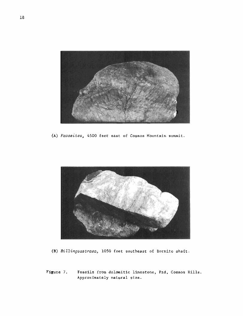
(A) Favosites, 4500 feet east of Cosmos Mountain summit.
(B) BiZZingsastraea, 1050 feet southeast of Bornite shaft .
Figure 7. Fossils from dolomitic limestone, Pzd, Cosmos Hills Approximately natural size.

( A ) Syringopora, 1050 feet southeast of Bornite shaft.
(B) Rugose coral, probably Siphonophrentis, 1050 feet southeast of Bornite shaft.
Figure 8. Fossils from dolomitic limestone, Pzd, Cosmos Hills. Approximately natural size.

Near Wye Creek, dark-gray t o b l a c k ca rbonaceous p h y l l i t e f o r m e r l y a s s i g n e d t o u n i t P z s ( F r i t t s , 1969, p 7 , f ig 2 ) h a s been remapped a s Pzdp, p r i m a r i l y because t h i s p h y l l i t e now a p p e a r s t o b e i n t h e same t h r u s t s l i c e a s t h e main d o l o m i t i c l i m e s t o n e . However, t h e l i m e s t o n e and p h y l l i t e a p p a r e n t l y a r e s e p a r a t e d by a h igh-ang le f a u l t n e a r Dahl Creek. Thus t h e p h y l l i t e exposed a t Wye Creek i s i n f a u l t c o n t a c t w i t h a l l a d j a c e n t r o c k s , and i t s s t r a t i g r a p h i c p o s i t i o n i s u n c e r t a i n , T h i s r o c k i s o n l y weakly metamor- phosed. Along t h e wes t bank of Dahl Creek, i t c o n t a i n s enough ca rbon t o b l a c k e n t h e hands of t h o s e h a n d l i n g t h e r o c k , b u t i t c o n t a i n s n e i t h e r g a r n e t n o r a l b i t e porphyro- b l a s t s l i k e t h o s e c h a r a c t e r i s t i c of u n i t Pzs f a r t h e r e a s t .
Greenstone and greenschist (Pzdg) -- Small b o d i e s of g r e e n s t o n e and g r e e n s c h i s t a s s o - c i a t e d w i t h r o c k s of t h e main d o l o m i t i c l i m e s t o n e were mapped s e p a r a t e l y a t two l o c a l - i t i e s s o u t h e a s t of B o r n i t e and a t a n o t h e r on t h e west s i d e of Cosmos Mountain. A t each l o c a l i t y , t h e g r e e n s t o n e and g r e e n s c h i s t appear t o b e approx imate ly p a r a l l e l t o bedding i n a d j a c e n t s t r a t a . The nor the rnmos t g r e e n s t o n e s o u t h e a s t of B o r n i t e is a medium-grained metagabbro composed main ly of p l a g i o c l a s e and a u g i t e p a r t l y a l t e r e d t o hornb lende , b u t i t a l s o c o n t a i n s c h l o r i t e , e p i d o t e , c a r b o n a t e , and a c c e s s o r y sphene. T h i s r o c k a p p e a r s t o form a s i l l - l i k e i n t r u s i v e s h e e t more t h a n 100 f e e t t h i c k . The o t h e r g r e e n s t o n e mapped i n t h a t a r e a is f i n e r g r a i n e d , d i s t i n c t l y s c h i s t o s e n e a r i t s edges , and 20 t o 30 f e e t t h i c k , It a l s o i s i n t e r p r e t e d a s a metamorphosed i n t r u s i v e m a f i c igneous r o c k . A much t h i n n e r unmapped g r e e n s c h i s t l a y e r i n p h y l l i t e i s exposed a b o u t 150 f e e t f a r t h e r w e s t . The g r e e n s c h i s t mapped n e a r Cosmos Mountain i s abou t 30 f e e t t h i c k and i s b e l i e v e d t o be a metamorphosed i n t r u s i v e r o c k . Extremely t h i n green- s c h i s t l a y e r s i n t e r p r e t e d a s m e t a t u f f a r e known t o be p r e s e n t i n t h e main d o l o m i t i c l i m e s t o n e a t B o r n i t e . The g r e e n s t o n e s d e s c r i b e d h e r e , t h e r e f o r e , p r o b a b l y r e p r e s e n t t h e i n t r u s i v e e q u i v a l e n t of v o l c a n i c r o c k s d e p o s i t e d d u r i n g o r a f t e r t h e main e p i s o d e of c a r b o n a t e s e d i m e n t a t i o n ,
Geologic age -- A Middle Devonian age h a s been a s s i g n e d t o t h e main d o l o m i t i c l i m e s t o n e on t h e b a s i s of f o s s i l s c o l l e c t e d from s e v e r a l l o c a l i t i e s i n t h e Cosmos H i l l s p r i o r t o 1968 ( P a t t o n , M i l l e r , and T a i l l e u r , 1 9 6 8 ) , P r e l i m i n a r y examina t ion of more f o s s i l s c o l l e c t e d by t h e w r i t e r from t h e s e and o t h e r l o c a l i t i e s i n t h e Cosmos H i l l s i n 1969 t e n d s t o conf i rm t h e Middle Devonian age , a l t h o u g h a d e t a i l e d examina t ion of t h o s e f o s s i l s had no t been completed by May 1970 (J. T. Du t ro , J r . , w r i t t e n comn~unica t ion) . R u n n e l l s (1963, p 17 ; 1969, p 77) c o r r e l a t e d t h e main d o l o m i t i c l i m e s t o n e of t h e Cosmos H i l l s w i t h t h e S k a j i t Limestone of t h e Brooks Range. Greens tone , which r e p r e s e n t s metamorphosed igneous r o c k i n t r u d e d i n t o t h e d o l o m i t i c l i m e s t o n e , canno t b e o l d e r t h a n Middle Devonian o r younger t h a n E a r l y Cre taceous (Metamorphism).
Upper phy ZZite and re lated rocks (Pzup, Pzud, Pzug)
A t h r u s t s l i c e composed p r i m a r i l y of p h y l l i t e , w i t h s u b o r d i n a t e g r e e n s t o n e and c a r b o n a t e r o c k s , o v e r l i e s t h e main d o l o m i t i c l i m e s t o n e i n t h e w e s t e r n p a r t of t h e Cosmos H i l l s , Th i s p h y l l i t e can be t r a c e d from t h e n o r t h e r n f a c e of Shungnak Mountain around t h e w e s t e r n end of t h e main window t o Cockscomb Ridge and J a y Creek. It may c o n t i n u e a c r o s s Ruby Creek p i n c h i n g o u t e a s t w a r d , a s s u g g e s t e d on f i g u r e 4 A , b u t t h i s r o c k i s n o t exposed e a s t of J a y Creek. The i n t e r p r e t a t i o n shown on t h e map, t h e r e f o r e , i s s p e c u l a t i v e . P h y l l i t e t h a t c a p s Aurora Mountain a p p a r e n t l y i s a remnant of t h i s t h r u s t s l i c e , a s sugges ted on c r o s s s e c t i o n s A and C ( f i g 4B),
PhyZlite (Pzup) -- The predominant p h y l l i t e i s medium d a r k g r a y and l i t h o l o g i c a l l y s i m i - l a r t o o t h e r weakly metamorpllosed p e l i t i c r o c k s d e s c r i b e d above, I t c o n s i s t s p r i m a r i l y of f i n e - g r a i n e d muscov i t e and q u a r t z , and c o n t a i n s n e i t h e r g a r n e t n o r a l b i t e porphyro- b l a s t s . The metamorphic g r a d e of t h e r o c k , t h e r e f o r e , i s much lower t h a n t h a t of t h e marble over which i t h a s been t h r u s t n e a r t h e Shungnak R i v e r .

Limestone and dolomite (Pxud) -- T h i n l y bedded l i m e s t o n e abou t 100 f e e t t h i c k c r o p s o u t i n a prominent c l i f f n e a r t h e head of S e r p e n t i n e Creek, b u t canno t b e t r a c e d f a r . Simi- l a r l y , d o l o m i t i c l i m e s t o n e r u b b l e i s abundant on a r i d g e a b o u t 1 m i l e s o u t h of t h e t h i n l y bedded l i m e s t o n e , b u t a p p e a r s t o b e i s o l a t e d from t h a t r o c k . Both of t h e s e c a r b o n a t e r o c k s a r e n e a r a n o t h e r major o v e r t h r u s t f a u l t and may b e o f f s e t by unrecognized f a u l t s . However, t h e r o c k s a r e i n t e r p r e t e d a s u n i t s i n t e r b e d d e d w i t h t h e main p h y l l i t e , Pzup. A p o o r l y p r e s e r v e d F a v o s i t e s was found i n d o l o m i t i c r o c k s o u t h of S e r p e n t i n e Creek i n 1969.
Greenstone (Pzug) -- Greens tone s i m i l a r t o t h a t of u n i t Pzdg a p p a r e n t l y i n t r u d e s r o c k s i n t h e lower p a r t of u n i t Pzud n e a r Alder and F i r e Creeks . However, t h e g r e e n s t o n e i s ex- posed mainly a s a g g r e g a t e s of c o a r s e r u b b l e . G r e e n s c h i s t i s n o t abundant i n u n i t Pzup.
GeoZogic age -- The age of t h e p h y l l i t e and c a r b o n a t e r o c k s i s b e l i e v e d t o be Devonian, mainly because t h e y a r e l i t h o l o g i c a l l y s i m i l a r t o t h e w e l l d a t e d Middle Devonian s t r a t a of t h e a r e a and c o n t a i n s i m i l a r f o s s i l s . However, t h e i r e x a c t s t r a t i g r a p h i c p o s i t i o n i s u n c e r t a i n because of o v e r t h r u s t f a u l t i n g . The a g e of t h e g r e e n s t o n e i n t h i s t h r u s t s l i c e i s b e l i e v e d t o b e comparable t o t h a t of u n i t Pzdg.
Upper carbonates (Pzuc)
Bedded c a r b o n a t e r o c k s l i t h o l o g i c a l l y s i m i l a r t o t h o s e d e s c r i b e d above c r o p o u t i n a few p l a c e s west of Moose Mountain and n o r t h of Cockscomb Ridge, b u t a r e g e n e r a l l y p o o r l y exposed. Near Cockscomb Ridge, they p robab ly a r e i n t e r b e d d e d w i t h p e l i t i c r o c k s (I. L . T a i l l e u r , unpub l i shed map). These rocks have n o t been c a r e f u l l y s t u d i e d by t h e p r e s e n t w r i t e r , b u t most l i k e l y a r e p a r t of t h e main t h r u s t - f a u l t e d s t r a t i g r a p h i c sequence of Devonian age .
Metubasalt and re lated rocks (Pzp, Pzv, Pza, PzZ)
A t h i c k f o r m a t i o n of weakly metamorphosed v o l c a n i c and sed imenta ry r o c k s i s exposed i n a b e l t as much as m i l e wide and 1 4 m i l e s l o n g a l o n g t h e s o u t h e r n and e a s t e r n s i d e s of t h e Cosmos H i l l s , and i n a b e l t a b o u t 2 m i l e s wide and 5 m i l e s long n o r t h e a s t of B o r n i t e . These r o c k s have been t h r u s t over t h e main d o l o m i t i c l i m e s t o n e (Pzd) and o t h e r s t r a t a d e s c r i b e d above, I n t h i s a r e a , t h e f o r m a t i o n i n c l u d e s a lower p h y l l i t i c member (Pzp) and a predominant upper me tavo lcan ic member (Pzv) , which c o n t a i n s l e n s e s of l i m e s t o n e ( P z l ) and agg lomera te ( ~ z a ) , Metavo lcan ic r o c k s s i m i l a r t o t h o s e of t h e upper member c r o p o u t on b o t h s i d e s of K o l l i o k s a k Lake and ex tend eas tward f o r many m i l e s th rough t h e Angayucham Mountains ( P a t t o n , M i l l e r , and T a i l l e u r , 1 9 6 8 ) . The t o t a l t h i c k n e s s of t h i s f o r m a t i o n i s u n c e r t a i n , It i s a t l e a s t 1500 f e e t n e a r Ferguson Peak i n t h e Cosmos H i l l s , b u t p robab ly i s s e v e r a l thousand f e e t i n t h e Angayucham Mountains ,
Lower phyZZitic member (Pzp) -- The lower member c o n s i s t s ma in ly of i n t e r b e d d e d p h y l l i t e , metagraywacke, and m e t a t u f f , Rocks of t h i s member a r e exposed i n t e r m i t t e n t l y o n l y from Ine revuk Mountain t o Dahl Creek, A westward e x t e n s i o n a c r o s s Wesley Creek i n f e r r e d i n p r e v i o u s r e p o r t s ( F r i t t s , 1969; P a t t o n , M i l l e r , and T a i l l e u r , 1968) was n o t conf i rmed i n t h e c o u r s e of d e t a i l e d mapping i n 1969. Although f i e l d r e l a t i o n s a l o n g t h e s o u t h e r n s i d e of t h e Cosmos H i l l s s u g g e s t t h e p o s s i b i l i t y t h a t u n i t s Pzp and Pzup a r e e q u i v a l e n t , such a r e l a t i o n s h i p i s n o t e v i d e n t n e a r B o r n i t e . The two p redominan t ly p e l i t i c u n i t s appear t o b e c o n f i n e d t o s e p a r a t e t h r u s t s h e e t s . West of Dahl Creek, some of t h e r o c k s of t h i s map u n i t a r e c h a r a c t e r i z e d by i n t i m a t e l y i n t e r l a y e r e d b l a c k p h y l l i t e and g r e e n i s h - g r a y m e t a t u f f beds a few m i l l i m e t e r s t h i c k , and t h e r o c k s a r e i n d i s t i n g u i s h a b l e from i n t e r - bedded p h y l l i t e and m e t a t u f f found i n u n i t Pzv a t S t o u t Mountain, I n t i m a t e l y i n t e r b e d d e d r o c k s l i k e t h e s e a r e n o t c h a r a c t e r i s t i c of u n i t Pzup. The m e t a t u f f of u n i t Pzp c o n s i s t s mainly of c h l o r i t e , a c t i n o l i t e , and e p i d o t e , and t h e p h y l l i t e c o n s i s t s l a r g e l y o f muscov i t e and q u a r t z , w i t h abundant a c c e s s o r y c a r b o n ,

Upper metavolcanic member ( P z v ) -- The upper member c o n s i s t s mainly of m e t a b a s a l t and m e t a t u f f , b u t a l s o c o n t a i n s moderate amounts of in te rbedded p h y l l i t e and metagraywacke a s w e l l a s s m a l l l e n s e s of c r y s t a l l i n e l i m e s t o n e , Massive, l o c a l l y amygdaloidal meta- b a s a l t i s w e l l exposed n e a r Moose Mountain, t h e heads of C a l i f o r n i a and Canyon Creeks, and a low k n o l l about 2$ m i l e s e a s t s o u t h e a s t of Camp 3 , Th is rock c o n t a i n s abundant p l a g i o c l a s e , e p i d o t e , and c h l o r i t e , and e x h i b i t s a r e l i c t d i a b a s i c t e x t u r e i n t h i n s e c t i o n . It c o n t a i n s numerous amygdules 1 t o 3 mm i n d iamete r f i l l e d w i t h c h l o r i t e . A t Moose Mountain, i t d i s p l a y s moderately w e l l p rese rved p i l l o w s t r u c t u r e s 1 t o 2 f e e t i n d iamete r . I n s e v e r a l p l a c e s , i t d i s p l a y s f ragmenta l t e x t u r e s t y p i c a l of maf ic l a v a f lows. Well-bedded meta tu f f composed of a c t i n o l i t e , e p i d o t e , c h l o r i t e , and a l b i t e i s abundant throughout t h i s member, e s p e c i a l l y a long t h e s o u t h e r n s i d e of t h e Cosmos H i l l s . It is w e l l exposed on S t o u t Mountain, and i s in te rbedded w i t h p h y l l i t e composed mainly of muscovi te , q u a r t z , a l b i t e , and probab le v e r y f i n e - g r a i n e d brown b i o t i t e , A l t e r n a t i n g beds of p h y l l i t e and meta tu f f t h e r e a r e a s t h i n a s 1 o r 2 mm, bu t many a r e much t h i c k e r . Rubble on t h e s o u t h s i d e of Moose Mountain i n c l u d e s p h y l l i t e , m e t a t u f f , metagraywacke, and impure q u a r t z i t e , Accessory m i n e r a l s i n t h e metavo lcan ic r o c k s a r e sphene, r u t i l e , hemat i t e , and m a g n e t i t e . A t a prominent knob n e a r t h e c e n t e r of t h e SW$ s e c . 22, T. 18 N . , R , 1 0 E . , t h e metavo lcan ic rocks c o n t a i n enough microscopic magne t i t e t o d e f l e c t a com- pass need le .
Agglomerate (Pza) -- Fragmental rock i n t e r p r e t e d h e r e a s metamorphosed agglomerate o r i n t r a f o r m a t i o n a l v o l c a n i c conglomerate c rops o u t n e a r t h e c e n t e r of s e c . 1 2 , T, 1 8 N . , R, 1 0 E . Th is rock i s c h a r a c t e r i z e d by a n ex t remely rough weathered s u r f a c e on which numerous u n s t r e t c h e d subangula r f ragments of m e t a b a s a l t a s much a s 1 0 i n c h e s i n diameter s t a n d o u t above t h e sur rounding f ine -gra ined m a t r i x , The fragments a r e l i t h o l o g i c a l l y s i m i l a r t o under ly ing amygdaloidal m e t a b a s a l t . The m a t r i x i s meta tu f f o r metasedimentary rock d e r i v e d from metavo lcan ic rock. The agglomerate o r conglomerate i s o v e r l a i n by g r e e n s c h i s t i n t h e s o u t h e r n p a r t of s e c , 1 2 , and a p p e a r s t o be p a r t of a conformable sequence of predominant ly metavo lcan ic s t r a t a (Pzv) . Fragmental metavo lcan ic rock a l s o i s a s s o c i a t e d w i t h m e t a b a s a l t i n and near t h e NE$ s e c , 1, T, 18 N . , R . 1 0 E . , bu t i s n o t d i f f e r e n t i a t e d on t h e g e o l o g i c map.
Limestone ( P z l ) -- Thin ly bedded l i m e s t o n e i s i n t e r l a y e r e d w i t h t h e metavo lcan ic s t r a t a (Pzv) a t Moose Mountain and i n many p l a c e s a long t h e s o u t h e r n s i d e of t h e Cosmos H i l l s . The l imes tone forms l e n s e s from l e s s than 1 f o o t t o a s much a s 60 f e e t t h i c k . I n g e n e r a l , t h e s e l e n s e s and bedding w i t h i n them a r e p a r a l l e l t o bedding and f o l i a t i o n i n t h e a d j a - c e n t metavo lcan ic rocks . However, a t Moose Mountain, bedding i n one such l i m e s t o n e i s markedly o b l i q u e t o t h e o u t l i n e of t h e l e n s mapped, i n d i c a t i n g s t r o n g i n t e r n a l deform- a t i o n and probab le s h e a r i n g a long t h e boundar ies of t h e l e n s . Th is i s t h e t h i c k e s t such l e n s i n t h e map a r e a , b u t a n o t h e r l a r g e one approximately 30 f e e t t h i c k i s w e l l exposed a t S t o u t Mountain, On t h e s o u t h s i d e of t h a t mountain, t h e l imes tone c o n t a i n s a l a y e r of greenish-gray meta tu f f approximately 20 f e e t long and a s much a s 1 4 f e e t t h i c k , which p a r a l l e l s bedding i n t h e l i m e s t o n e , The f i e l d r e l a t i o n s i n d i c a t e contemporaneous d e p o s i t i o n of l i m e s t o n e and t u f f ,
The l i m e s t o n e ( P z l ) i s a t l e a s t p a r t l y b i o c l a s t i c , and some of i t s t r o n g l y resembles c a l c a r e n i t e c h a r a c t e r i s t i c of t h e main d o l o m i t i c l imes tone (Pzd) . A t S t o u t Mountain, l imes tone a d j a c e n t t o t h e meta tu f f l e n s d e s c r i b e d above c o n s i s t s mainly of c a l c i t e , b u t c o n t a i n s numerous microscopic g r a i n s of c l a s t i c q u a r t z and macroscopic g r a i n s of dark- gray c l a s t i c c a l c i t e a s much a s 2 mm i n d i a m e t e r , I n t h i n s e c t i o n , some of t h e dark-gray c l a s t i c g r a i n s were recognized a s d i s t i n c t f ragments of c r i n o i d s r e p l a c e d by c a l c i t e , Much l a r g e r f ragments of c r i n o i d s were found i n s i m i l a r l imes tone f l o a t i n t h e s o u t h e a s t corner of s e c , 22, T, 18 N . , R . 1 0 E , The f l o a t t h e r e a p p a r e n t l y was d e r i v e d from a s m a l l body of b i o c l a s t i c l imes tone exposed about 1000 f e e t west nor thwest of t h e summit of Ferguson Peak, Fragments of c r i n o i d s tems from t h e Ferguson Peak l o c a l i t y a r e a s much a s 6 inch i n d iamete r and 4 i n c h l o n g , These c r ino id-bear ing l i m e s t o n e s a r e i n - d i s t i n g u i s h a b l e from cr ino id-bear ing l i m e s t o n e found w i t h i n t h e main d o l o m i t i c l i m e s t o n e (Pzd) about 1 m i l e e a s t of Cosmos Mountain, Three k i n d s of conodont (Hindeodel la s p . ,

~igonodina? sp., and Ozarkodina sp.) also have been identified in samples of the crinoid- bearing limestone collected by the writer at Ferguson Peak (J. LJ. Iluddle, written commu- ilication, June 1969). The conodonts, however, are rather scarce in tlie specimens of this rocK studied so far.
CeoZogic age -- The age of ttiis formation is reported here as iliddle Devonian(?) primar- ily on the basis of paleontological evidence and lithological similarity between lime- stones of units Pzl and Pzd. Previous estimates of the age of the predominantly meta- volcanic formation (Pzv) have ranged from Jurassic(?) (Patton, i,filler, and Tailleur, 1968) to possible Devonian (Fritts, 1969, p 12). The latter age \$as based partly on the pres- ence of crinoids in unit Pzl at Stout Hountain and Ferguson Peak, and partly on the pres- ence of phaceloids (rugose corals) of possible Devonian age in similar limestone inter- layered with the main metavolcanic formation near the 14aunelulc River about 11 miles east of I<ollioksak Lake. The presence ol locally abundant crinoids within the main dolomitic limestone (Pzd) of 14iddle Devonian age was not known until July 1969, but the crinoid- bearing rocks in both units (Pzd and Pzl) are so similar lithologically that similarity in geologic age also seems likely. The conodonts mentioned above are characteristic of rocks ranging in age from Ordovician to Triassic, and the ones collected from the Cosmos tiills could indeed be i4iddle devonian in age (J. W. Huddle, written communication, June 1969). Tuus the evidence presently available favors a i.liddle Devonian(?) rather than Jurassic ( ? ) age,
Cretaceous Rocks
ideiacong Zornerate and r e Zated rocks ( K s , Kp, &5)
The highest stratigraphic formation in ttle Cosmos Hills consists of a predominant con- gloi~leratic sandstone and slate unit of probable continental origin (IZs), with subordinate phyllite ( ~ p ) and n~etabasalt (Kb). These rocks have been thrust over underlying Devonian strata. In the lower part of the main map unit, especially within 400 or 500 feet of the underlying fault, the Cretaceous rocks have undergone pervasive shearing and low-grade dynan~ic or dynamo-triermal inetamorphisr~i which distinguish them from the underlying Devoni- an strata. Other distinguishing features in this area include an abundance of coarse clastic material and an apparent lack of limestone. The formation underlies more than 40 square miles in the western, southern, and eastern parts of the Cosmos Hills, and is cnaracteristic of rocks in the northern part of the IZobuk trough. The thickness of the Cretaceous strata in the Cosmos Hills is uncertain because of faulting, but probably is several thousand feet. In the Selawik quadrangle, at localities about 100 miles west of Kobuk, the thickness of equivalent rocks is at least 3000 feet and may be as much as 7500 feet, if underlying conglomerate of marine origin is included (Patton and Miller, 1968).
L'onyZomeratic sandstone and s Zate (Ks) -- The conglomeratic sandstone and slate unit is well exposed on mountain summits and flanks along the entire western, southern, and east- ern rims of the Cosmos Hills window, but severe frost action has reduced many outcrops to concentrations of slabby boulders 1-20 feet in diameter. The map unit consists of interbedded nletaconglomerate, metasandstone, metagraywacke, and phyllite or slate. Beds 1-6 feet thick are common. Fine-grained rocks exhibiting typical slaty cleavage were observed mainly south of an east-trending fault south of Ferguson Peak, but also are present in the western part of the area. Phyllite, metagraywacke, and metasandstone are widespread, but are especially abundant east of the Kogoluktuk River and west of the Shungnak diver. detaconglomerate also is widespread, but is coarsest and most abundant along the southern flank of the Cosmos Hills, especially in the vicinity of Dahl and Wesley Creeks. Common minerals in all of these rocks include quartz, muscovite, chlorite, biotite, and feldspar. Most cobbles and pebbles in the metaconglomerate are white quartz, ~ u t pebbles of metagraywacke, schist, greenschist, chert, and granitic gneiss presumably

derived from the ancestral Brooks Range also are present. No limestone pebbles or cobbles were noticed in the course of mapping by the writer. The largest clastic fragment found in the metaconglomerate was a quartz boulder 6 x 8 x 15 inches near Wesley Creek. Align- ment of stretched cobbles, pebbles, and grains in these sheared rocks gives them a con- spicuous lineation, which commonly trends northeast. Recognition of this feature is helpful in lmapping, because it enables the mapper to distinguish between outcrops and frost-heaved debris.
Highly sheared metaconglomerate characterized by extremely stretched and flattened pebbles and cobbles of greenschist is well exposed (1) within 100 feet of the uppermost overthrust fault mapped on the northwest side of Cosmos ilountain, (2) at the summit of Ferguson Peak, (3) near the divide between the heads of California and Canyon Creeks, and (4) on a north- trending spur on the west side of Kollioksak Lake. The matrix of these rocks commonly is grayish to purplish red, making them quite distinctive in the field. In the southeastern part of the Cosmos Bills, this kind of rock formerly was mapped separately (Fr i t t s , 1969, f i g 2) in the belief that it might represent part of a lowermost member of the main Creta- ceous formation described by Patton, Miller, and Tailleur (1968). However, similar red conglomerate characterized by fragments of volcanic rock now is known to be interbedded with the typical quartz-pebble conglomerate in the Angayucham Mountains. In the Cosmos Hills, the conglomerate containing greenschist fragments apparently was merely more easily deformed and altered close to the uppermost overthrust fault at the time of emplacement of intrusive serpentinite (see Serpentinite and serpentinization). At Cosmos Mountain within one foot of serpentinite intruded along that fault, numerous pebbles in this kind of con- glomerate consist mainly of antigorite, which strongly resembles antigorite characteristic of the adjacent serpentinized intrusive ultramafic rock. The field relations suggest that the conglomerate also has been serpentinized to a minor degree, or at least chloritized, during emplacement and alteration of the intrusive rock.
PhyZZite (Kp) -- Phyllite was mapped separately east of Wesley Creek primarily to emphasize the northeast trend of bedding where well foliated metaconglomerate predominates. Bedding and foliation there are parallel. In thin section, the phyllite is composed mainly of muscovite, quartz, and probable feldspar, but also contains scattered porphyroblasts of chlorite as much as 0.2 mm in diameter, which are oblique to foliation and bedding. This kind of porphyroblast is typical of pelitic rocks observed by the writer in New England, which have undergone metamorphism in the lower greenschist facies. Carbon also is present, but is less abundant than carbon in phyllite of Paleozoic age exposed near Dahl Creek.
MetabasaZt (Kb) -- Fine- to medium-grained, weakly metamorphosed, mafic volcanic rocks form two large generalized map units underlying 1 or 2 square miles each east of the Shungnak River and at least two smaller bodies near Shungnak and Bismark Mountains. The smallest unit near Shungnak Mountain is only about 20 feet thick and appears to be parallel to bed- ding in the adjacent clastic rocks. Mafic rocks showing good diabasic texture are char- acteristic of these units, but porphyritic rocks containing altered plagioclase phenocrysts several millimeters in diameter were found in rubble on the northern side of Shungnak ~ilountain. The rocks with diabasic texture range from basalt to gabbro in appearance, and fine-grained locally amygdaloidal basalt is typical at Shungnak Mountain. The basalt is brown on weathered surfaces and is easily recognized from the air. The rock consists mainly of plagioclase and augite, with small amounts of chlorite and magnetite. Chlorite commonly forms amygdules 1-3 mm in diameter. Amygdaloidal rocks with good diabasic texture are believed to be only slightly altered extrusive basalt. Coarse nonamygdaloidal rocks exposed near the Shungnak River may be the intrusive equivalent of the basalt. Although slightly altered, these rocks all appear to be much less metamorphosed than the greenschists and greenstones of Devonian age found in this area, and they do not contain interlayered limestone.
Geologic age -- A Late Cretaceous age was assigned to the metaconglomerate and related rocks of the Cosmos Hills by Patton, ivIiller, and Tailleur (1968) on the basis of corre- lation with similar rocks exposed in the Baird Mountains and Selawik quadrangles west of Kobuk. The conglomeratic strata in those quadrangles contain tuffaceous beds dated by

potassium-argon methods. The authors also reported that some of the strata exposed in the eastern part of the Cosmos Hills resemble igneous pebble-cobble conglomerate like that interbedded with fossiliferous mudstone and graywacke of probable Early Cretaceous age in the Selawik quadrangle (Patton and Miller, 1968). The age of this formation, therefore, is reported here as Early to Late Cretaceous. Runnells (1963, p 18, 19) correlated these rocks with strata of the Bergman and Koyukuk Groups.
INTRUSIVE ROCKS
Cretaceous Rocks
Granite (Kg)
Distr ibut ion and s i z e -- Gneissic granite forms a pluton as much as 1 314 miles in diameter near the Kogoluktuk River. This rock forms the core of a dome, and is surround- ed ~y the most highly metamorphosed strata in the map area. The granite is well exposed along the river and on ridges near Kadio and Lynx Creeks. Schist crops out in several places along the northern side of the pluton, providing good control for placement of the granite-schist contact there. Along the southern side, however, outcrops of granite and schist are as much as 1 mile apart. Thus the nearly circular outline of the pluton shown on the map is generalized and merely indicates the minimum area underlain by granite. Small unmapped bodies of pegmatitic to gneissic rock as much as 6 feet thick, which are believed to be related to the granite, were found near marble about 1% miles east of the pluton and in schist near Glacier Creek a comparable distance to the west. No other gran- ite bedrock was seen by the writer in the Cosmos Hills.
Garnetiferous greenstones and schists presumably metamorphosed at the time of granite emplacement are most abundant in an irregular belt at least 3 miles wide and 6 miles long, which trends approximately N 30 W from California Creek near Crescent Ridge to and beyond Black Rock Ridge. This belt includes the small pluton of intrusive granite, which is slightly elongate about parallel to the N 30 W trend. The field evidence suggests that the granite may extend beneath this belt of garnetiferous rock. The presence of schist and marble near the Shungnak River also suggests that granite was close to those rocks at some time in the past, but discordances in bedding there suggest that the rocks are complexly faulted rather than domed. In the opinion of the writer, granite very likely was associated with metamorphism of rocks now exposed near that river but was separated from them or covered by other strata during subsequent overthrust faulting.
Lithology -- The granite consists mainly of albite, microcline, quartz, and muscovite. Biotite is much less abundant. The microcline forms numerous crystalloblasts 112 to 314 inches long. Some are smeared out parallel to well developed foliation. Deformation of these crystals presumably occurred during a late stage of the emplacement and related metamorphism. Accessory minerals are sphene, carbonate, and zircon. Garnets 1-5 mm in diameter are present in some outcrops adjacent to schist. The granite is cut by minor aplite dikes and sills, which are oblique and parallel to foliation, respectively. Well developed jointing is characteristic.
Lithologies at the northernmost outcrops of the granite on the Kogoluktuk River clearly indicate that this rock intrudes the adjacent schist (Pzs). The granite there contains inclusions of garnetiferous muscovite schist similar to the host rock. The granite also contains distinct muscovite- and garnet-rich layers, which represent partly assimilated schist. Some layers contain stubby crystals as much as 3 mm in diameter, which resemble the albite porphyroblasts characteristic of the intruded schist (Pzs). Small nearly round albite crystals also are characteristic of granite gneiss found near marble east of Lynx Creek.

Geologic age -- An E a r l y Cre taceous age was a s s i g n e d t o t h i s g r a n i t e by P a t t o n , M i l l e r , and T a i l l e u r (1968) on t h e b a s i s of potass ium-argon d a t i n g of hornb lende c o l l e c t e d from a s m a l l i n c l u s i o n of c o u n t r y r o c k found i n soda a p l i t e a s s o c i a t e d w i t h t h e g r a n i t e (W. W. P a t t o n , J r , , o r a l communication, February 1970) . L a b o r a t o r y d a t a s u g g e s t a n a p p a r e n t a g e of 1 2 1 2 3 .8 m i l l i o n y e a r s f o r t h e hornb lende , which i s b e l i e v e d t o have formed, o r a t l e a s t r e c r y s t a l l i z e d , d u r i n g metamorphism d i r e c t l y r e l a t e d t o emplacement of t h e g r a n i t e . The r e p o r t e d f i g u r e , t h e r e f o r e , i s a minimum e s t i m a t e of t h e age of t h e g r a n i t e , which i s compa t ib le w i t h f i e l d e v i d e n c e . F i e l d r e l a t i o n s i n d i c a t e t h a t t h e g r a n i t e canno t be o l d e r t h a n Middle Devonian, because i t i n t r u d e d , deformed, and meta- morphosed a s t r a t i g r a p h i c sequence t h a t i n c l u d e s r o c k s of Middle Devonian a g e . The g r a n i t e presumably i s n o t younger t h a n E a r l y C r e t a c e o u s , because i t i s p a r t of a f o l d e d , f a u l t e d , and metamorphosed sequence over which s t r a t a of E a r l y t o L a t e Cre taceous a g e have been t h r u s t . Those s t r a t a were d e r i v e d from t h e a n c e s t r a l Brooks Range, which formed a s a r e s u l t of orogeny i n v o l v i n g g r a n i t e emplacement and o v e r t h r u s t f a u l t i n g ( S t r u c t u r e and g e o l o g i c h i s t o r y ) .
Quartz veins
Q u a r t z v e i n s , l e n s e s , and pods b e l i e v e d t o be r e l a t e d main ly t o metamorphism and g r a n i t e emplacement i n t r u d e metamorphosed Devonian s t r a t a . These v e i n s r ange i n t h i c k n e s s from l e s s and 1 i n c h t o more t h a n 4 f e e t . I n p h y l l i t e , t h e q u a r t z t e n d s t o be mass ive , w h i t e , approx imate ly p a r a l l e l t o bedding and f o l i a t i o n , and may c o n t a i n f e l d s p a r , muscov i t e , and p y r i t e . Massive q u a r t z f l o a t is e s p e c i a l l y abundant on a r i d g e of p h y l l i t e ahou t % m i l e e a s t s o u t h e a s t of t h e summit of S h i e l d Mountain, and r e p o r t e d l y c o n t a i n s go ld (Gold, under Economic geo logy) . I n c a r b o n a t e r o c k s , s i m i l a r v e i n s t e n d t o b e vuggy, o b l i q u e t o bedd ing , and may c o n t a i n n e a r l y c l e a r e u h e d r a l q u a r t z c r y s t a l s a s much a s 2 i n c h e s i n d i a m e t e r , i n a d d i t i o n t o minor c a r b o n a t e . Large q u a r t z c r y s t a l s were observed mainly i n v e i n s t h a t c u t u n i t s Pzc n e a r t h e head of Wesley Creek and Pzd n e a r t h e a d i t a t P a r d n e r s H i l l . Veins i n t h a t a r e a a l s o c o n t a i n copper s u l f i d e s and copper c a r b o n a t e s , which a r e b e l i e v e d t o be younger t h a n t h e main metamorphism (Copper, under Economic g e o l o g y ) .
Smal l q u a r t z v e i n s a l s o c u t L a t e Cre taceous s t r a t a and o b v i o u s l y canno t be r e l a t e d t o E a r l y Cre taceous metamorphism. I t i s p o s s i b l e t h a t some of t h e v e i n s c u t t i n g Devonian s t r a t a , t h e r e f o r e , may b e c o n s i d e r a b l y younger t h a n t h e g r a n i t e (Kg). Veins a r e d i s - cussed f u r t h e r under t h e head ings S e r p e n t i n i t e and Economic geology.
T e r t i a r y ( ? ) Rocks
Serpentini t e (2's l
S ize , shape, and d i s t r ibu t ion -- S e r p e n t i n i t e i n t h e Cosmos H i l l s forms numerous tabu- l a r i n t r u s i v e b o d i e s p a r a l l e l o r n e a r l y p a r a l l e l t o p l a n a r f e a t u r e s such a s bedd ing , f o l i a t i o n , and o v e r t h r u s t f a u l t s . These b o d i e s a r e from 100 f e e t t o 5 m i l e s l o n g b u t o n l y a b o u t 1 0 t o 400 f e e t t h i c k . They a r e good examples of t h e a l p i n e - t y p e u l t r a m a f i c r o c k s t h a t a r e d e r i v e d from t h e e a r t h ' s m a n t l e and a l t e r e d d u r i n g emplacement i n i n t e n s e - l y deformed o r o g e n i c b e l t s (Benson, 1926, p 6 ) . I n t h i s a r e a , s e r p e n t i n i t e i s most abun- d a n t a l o n g t h e s o u t h e r n and w e s t e r n s i d e s of t h e Cosmos H i l l s window, where s h e e t s of t h i s r o c k s e v e r a l m i l e s l o n g b u t l e s s t h a n 100 f e e t t h i c k have been emplaced a l o n g a major o v e r t h r u s t f a u l t b e n e a t h s t r a t a of E a r l y t o L a t e Cre taceous age . The s e r p e n t i n i c e t h e r e i s h i g h l y s h e a r e d , and t h e common t h i c k n e s s of 1 0 t o 50 f e e t t e n d s t o b e exagger- a t e d by s e v e r e s lumping on s t e e p s l o p e s . The l o n g e s t o r b r o a d e s t s h e e t i s exposed n e a r Shungnak and Cosmos Mountains . The t h i c k e s t one is a b o u t 1 m i l e n o r t h w e s t of Ferguson Peak. I n a few p l a c e s such a s Asbes tos Mountain and Knob H i l l , t a b u l a r , g e n t l y i n c l i n e d

s e r p e n t i n i t e b o d i e s have been emplaced n e a r t h e a x i s of a major a n t i c l i n e w i t h i n t h e window, b u t t h i s r o c k i s r a r e a l o n g t h e n o r t h e r n f l a n k of t h e main s t r u c t u r e e a s t of t h e Shungnak R i v e r . T y p i c a l s i l l - l i k e and g e n t l y i n c l i n e d d i k e - l i k e b o d i e s of se rpen- t i n j t e a r e shown on g e o l o g i c c r o s s s e c t i o n s A , C th rough II, and J (fig 4 B ) . The compos i t ion and d i s t r i b u t i o n of t h i s r o c k s u g g e s t t h a t i t s s o u r c e was a t g r e a t d e p t h soniewhere s o u t h o r sou thwes t of t h e Cosmos H i l l s , pe rhaps benea th t h e w e s t e r n end of t he Kobuk t rough (fig 2 ) .
T h e l a r g e a p p a r e n t l y i s o l a t e d body of s e r p e n t i n i t e a t Asbes tos Mountain i s one of t h e h i g h e s t , most consp icuous , and most c o n t r o v e r s i a l i n t h e map a r e a . It can be s e e n e a s i l y from t h e Dahl Creek a i r s t r i p . The mapped o u t l i n e of t h i s body i s mainly t h e o u t l i n e of a n a r e a c o n t a i n i n g i n t e r m i t t e n t o u t c r o p s and abundan t , tough , a n g u l a r , f r s s t - . heaved s e r p e n t i n i t e b o u l d e r s a s much a s 1 0 f e e t i n d i a m e t e r , which undoubtedly have not. moved f a r . T h i s body f o r m e r l y was i n t e r p r e t e d a s p a r t of a +shape s t o c k e x t e n d i n g from t h e mountain summit southward t o t h e c o n f l u e n c e of Dahl and S t o c k l e y Creeks (Heide, Wright and Kut ledge , 1949, f i g 9 , a f t e r Coa t s , 1943, f i g 1 ) . However, no i n d i s p u t a b l e ev idence was found d u r i n g t h e r e c e n t mapping t o i n d i c a . t e t h a t t h e s m a l l b o d i e s of s e r p e n t i n i t e exposed t h e r e p r e s e n t l y a r e connected t o one a n o t h e r o r t o t h e l a r g e body a t t h e mountain summit. Fur the rmore , t h e magne t i c e x p r e s s i o n of t h e main s e r p e n t i a i t e a t Asbes tos Mountain s u g g e s t s a " s i l l - l i k e form" (Chadwic-lc, 1960, p 5 ) . When viewed from t h e s o u t h , t h e mountain r e sembles a mesa capped by s e r p e n t i n i t e . The cap i s i n t e r p r e t e d h e r e a s a g e n t l y i n c l i n e d d i k e 150 t o 200 f e e t t h i c k o b l i q u e t o t h e c o n t a c t between f o r m a t i o n s Pzs and Pzg, a s shown on c r o s s s e c t i o n s A and G (fig SB). S e c t i o n G a l s o s u g g e s t s t h a t t h i s d i k e may have extended southward t o t h e c o n f l u e n c e of Dahl and Stock- l e y Creeks p r i o r t o e r o s i o n r e s p o n s i b l e f o r t h e p r e s e n t topography , b u t such a n ex ten- s i o n i s n o t r e q u i r e d by t h e a v a i l a b l e f i e l d ev idence . The p o i n t t h a t d e s e r v e s t h e most emphasis h e r e i s t h a t f i e l d r e l a t i o n s i n t h e v i c i n - i t y of Asbes tos Mountain do n o t i n d i - - c a t e a g r e a t l a t e r a l e x t e n t o r v e r t i c a l t h i c k n e s s of s e r p e n t i n i t e a t t h a t l o c a l i t y .
LZ bho logy -- The u l t r a m a f i c r o c k s of t h e Cosmos H i l l s have undergone s h e a r i n g and b r e c c i a t i o n a s w e l l a s complete r e c r y s t a l l i z a t i o n t o s e r p e n t i n i t e and r e l a t e d m i n e r d l s , Shear ing i s most i n t e n s e i n t h e s e r p e n t i n i t e found a l o n g t h e uppermost o v e r t h x u s t f a u l t n e a r Ine revuk , Cosmos, Shungnak, and Bismark Mountains . llany "ou tc rops" t h e r e , espe- c i a l l y wes t of Cosmos Creek, c o n s i s t a l m o s t e n t i r e l y of l i g h t - g r e e n i s h - g r a y t o da rk -g reec s e r p e n t i n i t e c h i p s + t o 2 i n c h e s i n d i a m e t e r c h a r a c t e r i z e d by smooth s l i c k s u r f a c e s . ' r l ~ e s e e x p o s u r e s a l s o c o n t a i n s c a t t e r e d nodu les and b l o c k s of r e l a t i v e l y unsheared serperl t i n i t e from a few i n c h e s t o 1 0 f e e t i n d i a m e t e r . More mass ive o u t c r o p s i n t h e same b e l t e x h i b i t b r e c c i a t e d s e r p e n t i n i t e c o n t a i n i n g f ragments from $ t o 6 i n c h e s i n d i a m e t e r . Such e x p o s u r e s a l s o show l e n s e s of r e l a t i v e l y unsheared s e r p e n t i n i t e a s much a s 5 f e e t t h i c k and 1 5 f e e t l o n g , which commonly p a r a l l e l f o l i a t i o n . The p e r i m e t e r s of some of t h e i n t r u s i v e b o d i e s a p p e a r t o be more f o l i a t e d t h a n t h e c e n t r a l p a r t s , and t h e i o l i a t i o n t e n d s t o be rough ly p a r a l l e l t o t h e i r b o u n d a r i e s , However, a c o n t a c t between t h e i n t r u - s i v e r o c k and t h e o v e r l y i n g cong lomera t i c h o s t r o c k i s exposed f o r approx imate ly 150 f e e t on tile n o r t h w e s t s i d e of Cosmos Mountain, and t h e s e r p e n t i n i t e t h e r e i s n o t a s s t r o n g l y ~ h e a r e d a s rock i n o t h e r p a r t s o f t h e same b e l t . S e r p e n t i n i t e f a r t h e r from major f a u l t s t e n d s t o e x h i b i t a h i g h e r p r o p o r t i o n of r e l a t i v e l y u n f o l i a t e d o r unsheared m a t e r i a l bu t i n d i v i d u a l o u t c r o p s commonly show minor s h e a r zones and s l i c k e n s i d e d j o i n t s a l o n g whfch movement undoubtedly h a s o c c u r r e d . I n e x c a v a t i o n s a t Asbes tos Mountain, Heide , Wright and Kut ledge (1949, p 1 2 ) found two main s e t s of n e a r l y v e r t i c a l f r a c t u r e s s t r i k i n g n o r t h e a s t and n o r t h w e s t and a t h i r d s e t n e a r l y h o r i z o n t a l . Blocky r u b b l e u s u a l l y i s abundant n e a r o u t c r o p s c o n t a i n i n g such f r a c t u r e s .
Where l e a s t s h e a r e d , t h e t y p i c a l s e r p e n t i n i t e i s composed l a r g e l y of v e r y f i n e - g r a i n e d a n t i g o r i t e . C r y s t a l s of t h i s m i n e r a l commonly a r e l e s s t h a n 0 .2 mm i n d i a m e t e r . One t h i n s e c t i o n of s e r p e n t i n i t e c o l l e c t e d n e a r Wesley Creek e x h i b i t s a t e x t u r e w i t h numerous s m a l l curved f r a c t u r e s s u g g e s t i n g t h a t t h e r o c k formed by complete a l t e r a t i o n of d u n i t e n r o l i v i n e - r i c h p e r i d o t i t e . No o l i v i n e o r pyroxene, however, h a s been i d e n t i f i e d by the w r i t e r i n s e r p e n t i n i t e from t h e Cosmos H i l l s . A few samples from t h e same l o c a l i t y r e semble

porphyritic rocks, because they contain antigorite crystals as much as 3 nun in diameter set in a matrix of very fine-grained antigorite. Porphyritic-looking serpentinite also was found south of Stockley Creek and north of Tent Creek, where the rock contains numer- ous anhedral carbonate crystals as much as 5 mm in diameter scattered through a matrix of very fine-grained antigorite. The carbonate, however, appears to be replacing anti- torite. In all of the serpentinite, fine-grained disseminated magnetite is a common accessory mineral, It is abundant enough in some hand samples to deflect a compass needle, and is plentiful enough in outcrops to make magnetic bearings unreliable. Other accessory minerals are pyrite and chromite. Weathered surfaces on the typical massive serpentinite commonly are rusty brown due to the presence of iron. A few are nearly black suggesting the presence of manganese. The brown surfaces are quite distinctive and can be recognized from as far as 5 miles away.
Several of the more interesting or unusual minerals and elements found in the map area are associated with the serpentinite. Many outcrops exhibit tiny veinlets of tremolite and (or) chrysotile 1-2 mm wide. Although large ones are uncommon, veins of asbestiforrn tremolite and chrysotile as much as 6 inches wide have been found at Asbestos Mountain (Heide, Wright, and Kutledge, 1949, p 11, 12). Most of the asbestos fibers are less than 3 inches long, but rate 18- to 20-inch fibers have been reported from that locality. iiemalite, an iron-bearing fibrous variety of brucite, has been found at Bismark Mountain (idem., fig 5A, p 10, 11). Fibrous serpentine crystals as much as 8 inches long were seen by the writer southeast of the summit of Knob Bill and in sec. 10 west of Dahl Creek. Near the head of Harry Creek and north of Tent Creek, float derived from small bodies of serpentinite includes talc and dolomite crystals as much as 1 inch long and coarse tremolite-actinolite rock, which contains small lenses of fine-grained, vivid green, chromium-bearing muscovite. The nephrite variety of jade has been found at Asbestos dountain (Coats, 1943). Green boulders currently recovered from Dahl Creek placers for sale as jade undoubtedly were derived from the serpentinite. Chromite masses as much as 1 foot in diameter also have been recovered from those placers (Smith and Eakin, 1911, p 294) and are believed to have been derived from the serpentinite. Rhodochrosite possibly derived from this rock was recovered from the Stewart claim on Dahl Creek north- east of Camp 1 in 1969. Minor nickel has been identified in antigorite associated with chrysotile near Stockley Creek (U. S. Bur. Mines, 1944, p 5; Anderson, 1945, p 7), but is not plentiful enough to constitute a potential source of nickel under present economic conditions.
Helationship to uZtramafic rocks of the Jade hlountains -- The serpentinite of the Cosmos Hills is believed to be genetically related and equivalent to partially serpentinized peridotite and dunite found along the southern side of the Jade Mountains (fig 2). The serpentinized peridotite and dunite there constitute the largest and westernmost body of ultramafic rock exposed along the north edge of the Kobuk trough, Thick units of carbon- ate and metavolcanic strata of pre-Cretaceous age and conglomeratic strata of Cretaceous age mapped in the Jade Mountains by Patton, Miller, and Tailleur (1968) are believed to be equivalent to rocks of units Pzd, Pzv, and Ks, respectively, of the Cosmos Hills. A thin unit of pelitic rocks of pre-Cretaceous age between the metavolcanic and carbonate strata in the Jade I4ountains occupies a position comparable to that of unit Pzup or Pzp of the Cosmos Hills. The authors showed that the main metavolcanic unit in the Jade llountains dips gently toward the south-southwest. On the basis of their mapping and aerial reconnaissance by the writer, a generalized geologic cross section (fig 9) has been constructed to show that the serpentinized ultramafic rock exposed along the south- ern side of the Jade Ilountains can be interpreted as a tabular sheet as much as 800 feet thick and more than 8 miles long, which dips southwestward as much as 15'. Cretaceous strata exposed at the southeastern end of the Jade Mountains are believed to extend west- ward beneath a broad area covered by surficial materials immediately south of that ultra- mafic sheet. The general geologic setting of the main bedrock units in the Jade Mountains, therefore, appears to be grossly similar to that of bedrock units on the southern side of the Cosmos Hills window, with serpentinized intrusive ultramafic rock emplaced along or near a major overthrust fault now believed to underlie Cretaceous strata in both areas.
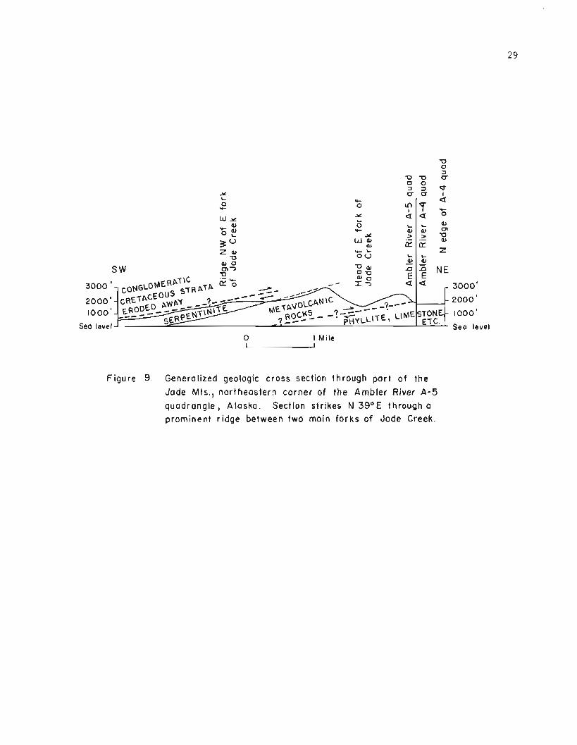
Y L
urr I .I-
0 0 a rC
w u -Y1 7 v-
L a a 0
.c 0
O F Y- L L
Y @ a , m
3* u a, > > -g
a, z a, w- L
E E 0
a, 0 0 0 L L
S W a-3 '0 a, 2 2
0-0 E n t? NE 0
/ IT a a - 3000' - 2000 '
Sea level - Sea level 0 I Mile
Figure 9. Generalized geologic cross section through part o f the
Jade Mts., northeastern corner of the Ambler River A - 5 quadrangle, Alaska. Section strikes N 3g0E through a
prominent r idge between two main fo rks of Jade Creek.

Serpent in izat ion -- Serpentinization of dunite and peridotite is believed to occur in the presence of water at tempexatuxes far below those at which magmas of eppropriate ultramafic composition should crystallize. 0'~ara (in Wyllie, 1967, fig 1.2, p 10) has shown that dunite (mainly olivine) should crystallize at about 1900° C. and harzburgite (mainly olivine and orthopyroxene) at about 1600" C., whereas the temperature of normal basalt at volcanic vents is about 1100" to 1200' C. He also reviewed evidence indicating that alpine-type peridotites probably have reached equilibrium under widely varying geo- logic conditions involving pressures from 0 to 20 kilobars and temperatures from 400' to 1200" C. (idem p 403). However, the lack of wide metamorphic aureoles around many dunite and peridotite bodies has led to the general belief that they are tectonically trans- ported from the mantle and are squeezed into the earth's crust as warm crystal mushes or nearly solid masses rather than flowing as extremely hot molten material. Upon contact with water, presumably present in the invaded host rock, serpentinization occurs along the edges of large intrusive masses or throughout small ones under the right conditions, thereby lubricating the masses and facilitating further movement. Serpentinization is believed to occur within the approximate ranges of 1 to 12 kilobars and 250' to 500' C., with temperatures most likely 400" to 500' (idem fig 1.4, p 10, fig 12.6, p 402). Deer, Howie, and Zussman (1966, fig 79, p 229) suggest that serpentine probably can exist to depths of about 7 miles.
Field evidence in the Cosmos Hills suggests moderate temperature and pressure at the time of serpentinization there, most likely at a depth of 2 or 3 miles. Along the southern side of this highland, Cretaceous strata within several hundred feet of the overthrust fault that underlies them have been subjected to metamorphism of the lower greenschist facies during the latest episode of overthrust faulting (Phyllite, Kp, and Metamorphism). Along the serpentinite-conglomerate contact exposed on the northwest side of Cosmos Mountain, conglomerate within about 1 foot of the intrusive serpentinite is highly altered. Thin sections of the altered rock show that lithic fragments and matrix both have been completely replaced by antigorite. Nunlerous tiny garnets less than 0.1 mm in diameter have formed along the rims of such fragments and in the adjacent matrix. The garnet has been identified by X-ray diffraction as largely grossularite or perhaps a hydrated variety of that mineral. Deer, Howie, and Zussman (1966, p 25) report that antlydrous grossular has been produced in the laboratory at 500" C., and probably is stable with water to 400' C. In contrast, the writer has mapped contacts in Connecticut where the emplacement of an intrusive diabase sheet of Triassic age 100 to 700 feet thick and 18 miles long has merely discolored conglomeratic arkose and siltstone of the Newark Series for about 100 feet above the diabase without large-scale recrystallization. At the time of emplacement, the diabase was overlain by clastic sediments having a thickness of 1Li to 2 miles or more.
Serpentinization of the ultramafic rock exposed in the Jade Mountains apparently has been incomplete in the central part of the intrusive sheet exposed there (fig 9) but rather thorough along its edges. Heide, Wright, and Rutledge (1949, p 13, 14) reported that serpentinization has been least thorough in some of the lowermost outcrops along Jade Creek on the southwestern side of the Jade Mountains and in downfaulted ultramafic rock mapped by Patton, Miller, and Tailleur (1968) at the southeastern end of that highland. The lowermost outcrops along Jade Creek, for example, reportedly expose rocks composed largely of pyroxene and olivine, which probably are characteristic of the innermost part of the intrusive sheet. The degree of serpentinization of the rock increases northeast- ward toward what now is interpreted as the base of the sheet. Serpentinite also pre- dominates along the crest of the ridge between the East and West Forks of Jade Creek, where the upper part of the sheet apparently is exposed (fig 9). The incompleteness of serpentinization of the original peridotite and dunite probably is due, in part, to the rather large apparent thickness of the inferred intrusive sheet. The field relations resemble those in the Twin Sisters Range of northwestern Washington, where serpentini- zation began along the edges of a large mass of dunite and proceded inward in the pres- ence of water derived from the invaded country rock (Ragan, D. M., Wyllie, 1967, p 165).

Serpentinization in the Cosmos Hills and Jade 14ountains apparently occurred during the last episode of overthrust faulting, perhaps in or continuing until a late stage of that tectonic activity. Pebbles in conglomerate adjacent to serpentinite at Cosmos Mountain are somewhat flattened and stretched, indicating proximity to the uppermost overthrust fault mapped there. However, thin sections of serpentinized conglomerate from within 1 foot of the intrusive rock still display distinct pebble outlines, and individual grains and crystals do not show the extreme undulatory extinction or granulation typical of highly cataclastic rocks or mylonite. This evidence suggests that (1) final hydrothermal activity associated with serpentinization may have occurred after most of the movement along the overthrust fault there had taken place, (2) the exposed contact may be above the main fault, or (3) the serpentinite may have lubricated the fault so that final displace- ment took place within the serpentinite, which is known to be highly sheared in other parts of this belt.
Veins r?eZuted to serpentinizakion -- Veins of hydrothermal origin undoubtedly related to serpentinization of the original intrusive ultramafic rock were observed in several places, Veins of coarse, crystalline talc as much as 4 inches wide are visible near the eastern edge of the main serpentinite body at Asbestos Mountain. Small masses of soap- stone were mapped there by Heide, Wright, and Rutledge (1949, fig 10). A 2- to 6-inch vein of talc and carbonate and a 1-foot vein of tremolite-actinolite rock with minor chrome-muscovite are associated with limestone on a north-trending ridge about 2% miles west southwest of Camp 3. Veins of quartz-carbonate rock containing minor chrome- muscovite and pyrite intrude limestone near a saddle at the top of Shield Mountain. At that locality, a vein system as much as 20 feet wide is composed of several nearly paral- lel veins as much as 4 feet wide. At Camp 4, a sill-like vein of coarse tremolite- actinolite rock with minor chrome-muscovite intrudes a sequence of schist, marble, and greenschist in a prominent cliff on the east side of the Shungnak River. This vein is at least 50 feet long and as much as 1 foot wide. Smaller lenses and pods of similar material intrude rocks nearby. The main vein there contains numerous bundles and fan- shape aggregates of bright green actinolite crystals as much as 2 inches long, which are much coarser than the actinolite characteristic of greenschist and greenstone in the map area. Hand samples show tiny veinlets of white tremolite 1-2 mm wide cutting across coarse actinolite. Talc is present in rocks on the opposite side of the river. Boulders of serpentinite slabbed at the Stewart jade claim on Dahl Creek display numerous random veinlets of magnetite 1 to 3 mm wide and 1 to 2 inches apart cutting serpentinite that contains disseminated fine-grained magnetite. These veinlets apparently formed during a late stage of the hydrothermal activity related to serpentinization.
Geologic age -- The serpentinite cannot be older than Late Cretaceous and may be as young as Early Tertiary. Field relations along the exposed contact at Cosmos Mountain described above clearly indicate that conglomerate of Late Cretaceous age was altered during the same hydrothermal activity that was responsible for serpentinization of the intrusive rock during its emplacement. Small bodies of similar serpentinite that appar- ently intrude Cretaceous strata also have been mapped at Cosmos and Bismark Mountains as much as a few hundred feet above the overthrust fault that underlies those strata. Ser- pentinite float at least 80 feet above this fault on the west side of Wesley Creek indi- cates that another unmapped lens of serpentinite probably intrudes conglomerate there. The serpentinite now is believed to have been emplaced during a late stage of the over- thrust faulting that displaced the strata of Early to Late Cretaceous age. This tectonic activity is believed to have occurred mainly in latest Cretaceous and Early Tertiary time, although its upper limit is uncertain (Structure and Geologic History). The age of the serpentinite, therefore, is reported here as Tertiary (? ) .

3 2 STRUCTURE
The p r i n c i p a l geo log ic s t r u c t u r e s now recognized i n t h e Cosmos H i l l s a r e a dome n e a r i n t r u s i v e g r a n i t e i n t h e v i c i n i t y of t h e Kogoluktuk R i v e r , an a n t i c l i n e ex tend ing west- ward from t h e dome toward Wesley Creek, a p o s s i b l e h o r s t which i n c l u d e s t h e dome and a n t i c l i n e , and a complex window which i n c l u d e s a l l of t h o s e s t r u c t u r e s . Other s t r u c - t u r a l f e a t u r e s i n c l u d e high-angle f a u l t s of a t l e a s t two a g e s , low-angle o v e r t h r u s t f a u l t s , minor f o l d s , c r e n u l a t i o n s , and widespread l i n e a t i o n .
Dome Near Kogoluktuk River
The dome n e a r t h e Kogoluktuk River c o n s i s t s of s e v e r a l thousand f e e t of p h y l l i t i c s c h i s t and r e l a t e d rocks (Pzs , p z c , Pzg ) which d i p outward away from i n t r u s i v e g r a n i t e (Kg) . The domed rocks appear t o have been o f f s e t by high-angle f a u l t s , i n s e v e r a l p l a c e s . The main s t r u c t u r e i s shown on c r o s s s e c t i o n s A and I ( f ig 4B) . The l a r g e b o d i e s of green- s t o n e (Pzg) mapped n e a r Crescent and Black Rock Ridges a r e t h e youngest of t h e domed rocks . The i r d i s t r i b u t i o n i n r e l a t i o n t o t h e g r a n i t e i s s l i g h t l y asymmetr ical , b u t doming a s w e l l a s metamorphism a p p a r e n t l y accompanied emplacement of t h e g r a n i t e . A n e a r l y t r i a n g u l a r fau l t -bounded(?) a r e a of g reens tone a s much a s 1 m i l e wide i n t h e v i c i n - i t y of Black Rock Ridge a p p e a r s t o have been s t r o n g l y t i l t e d a f t e r t h e main doming, b u t t h e reason f o r t h e t i l t i n g i s obscure .
A n t i c l i n e Near Wesley Creek
A major a n t i c l i n e ex tends westward from Asbestos Mountain t o t h e v i c i n i t y of Lone Moun- t a i n , b u t does n o t i n v o l v e t h e main d o l o m i t i c l imes tone (Pzd) exposed t h e r e . The f o l d plunges westward n e a r t h e head of Wesley Creek, b u t i s f l a t t e r and broader n e a r Lone ~* lounta in , where sha l low f o l d s a r e superimposed on t h e main one. The a n t i c l i n e i s o f f s e t by t h e J a y Creek f a u l t wes t of Lone Mountain, bu t probably con t inues westward f o r a t l e a s t 2 m i l e s . The long u n i t of nor th-dipping l i m e s t o n e (Pzc) mapped s o u t h of Aurora d o u n t a i n and Pardners H i l l i s i n t e r p r e t e d a s p a r t of t h e n o r t h e r n l imb of t h e a n t i c l i n e , a l though t h i s l i m e s t o n e i s poor ly exposed i n some p l a c e s . The apparen t absence of e q u i v a l e n t l i m e s t o n e on t h e s o u t h e r n l imb s u g g e s t s t h a t t h e l i m e s t o n e e i t h e r pinched o u t southward o r was o f f s e t by unrecognized f a u l t s . The q u e r i e d o v e r t h r u s t f a u l t bounding a n e a r l y c i r c u l a r a r e a a t t h e west end of t h e a n t i c l i n e i s h i g h l y s p e c u l a t i v e , and s t r u c t u r e i n t h a t a r e a of poor exposure may be q u i t e d i f f e r e n t from t h a t sugges ted on t h e p r e s e n t g e o l o g i c map.
Hors t and Early High-Angle F a u l t s
A major h o r s t fo rmer ly was i n f e r r e d n e a r t h e Kogoluktuk River where g r a n i t e and s c h i s t s were thought t o have been upthrown r e l a t i v e t o l e s s metamorphosed r o c k s of t h e a r e a . Read and Lehner (1959) i n f e r r e d such a s t r u c t u r e about 2 m i l e s wide benea th t h e v a l l e y of t h e Kogoluktuk. F r i t t s (1969, p 20, f i g 2) expanded t h a t concept and i n f e r r e d t h a t t h e h o r s t was about 6 m i l e s wide , Th is s t r u c t u r e i n c l u d e d t h e g r a n i t e and domed s t r a t a near t h e Kogoluktuk River and was bounded by nor th - t rend ing f a u l t s i n f e r r e d n e a r Lynx and Oahl Creeks. The Lynx Creek f a u l t accounts f o r marked changes i n bedding a t t i t u d e s and topography near t h e head of Lynx Creek and f o r t h e a b r u p t eastward t e r m i n a t i o n of

garnetiferous greenstone (Pzg), which is in apparent fault contact with nongarnetiferous phyllite near Crescent Ridge and California Creek. Displacement on this fault was thought to be at least 1000 feet. The Dahl Creek fault was mapped to account for the abrupt eastward termination of some 1500 feet of dolomitic limestone (Pzd) at the west bank of Dahl Creek and was inferred to extend northward beneath the valley of Ryan Creek. At that time, the dolomitic limestone was thought to be in normal stratigraphic position above the underlying phyllite (Pzs), although alternative interpretations had been consid- ered and discussed with other geologists. After recognition of a major overthrust fault beneath the dolomitic limestone in 1969, it appeared likely that the Dahl Creek fault is offset by two major overthrust faults, and a fault beneath the valley of Ryan Creek seemed unlikely. If a major horst exists inside the Cosmos Hills window, it apparently is bounded by the Lynx Creek and Jay Creek faults and is at least 11% miles wide. Displace- ment on both of those faults is uncertain, but probably is many hundreds of feet. These fractures and others within the possible horst apparently formed during an episode of block-faulting after granite emplacement and metamorphism of the Devonian strata but before overthrust faulting.
Cosmos Hills Window and Low-Angle Overthrust Faults
The most important structure in the Cosmos Hills is a window about 20 miles long and 2 to 8 miles wide here called the Cosmos Hills window. This structure formerly was thought to be bounded by only two major overtlirust faults (Fritts, 1969, fig I ) but now is known to be much more complex. At least four major overthrust faults have been recognized beneath formations Pzd, Pzup, Pzv, and Ks, respectively. None of these faults completely encir- cles the window on the map, but collectively the allochthonous rocks above them form the frame of the main structure. If only the uppermost allochthonous strata of Cretaceous age were considered the frame, tlie structure probably would be best described as a semi- window.
Field evidence for the overthrust faults is indisputable. The fault beneath unit Pzd was recognized primarily on the basis of field relations near Ruby Creek. Approximately 1500 feet of thinly bedded limestone is characteristic of the lower part of the formation exposed east of that creek, but equivalent limestone is missing on the western side. There is no evidence for an unconformity or conglomerate at the base of the formation in that area, and bedding in the limestone commonly is steeper than the underlying contact now interpreted as an overthrust fault. The fault beneath unit Pzup was recognized pri- marily on the basis of a marked discordance in bedding between this formation and unit Pzd at Shungnak Mountain and a conspicuous difference in the metamorphic grade of non- garnetiferous phyllite and marble in these formations near the Shungnak River. Evidence for a fault beneath unit Pzv includes a discordance in bedding between this formation and unit Pzs near Stout Mountain and a difference in metamorphic grade between units Pzv and Pzg near Ferguson Peak. Evidence for the fault beneath unit Ks includes structural dis- cordances at Kollioksak Lake and several places along the southern side of the Cosmos Hills, plus a marked difference in the degree of internal shearing in unit Ks compared to underlying Devonian strata. On the northwest side of Cosmos Mountain, where a thin sheet of serpentinite was emplaced along the uppermost thrust, differential weathering has accentuated the position of this fault making it easily recognizable from miles away (fig 2 0 ) .

F i g u r e 10. Gent ly i n c l i n e d o v e r t h r u s t f a u l t on northwest s i d e of
Cosmos Mountain. S e p a r a t e s c o a r s e c l a s t i c s t r a t a of
summit from under ly ing n e a r l y h o r i z o n t a l l imes tone .
The d i r e c t i o n of movement a long t h e lower t l i r ee o v e r t h r u s t f a u l t s i s u n c e r t a i n , b u t i s b e l i e v e d t o have been mainly toward tlie n o r t h - n o r t h e a s t . Evidence f o r such movement i n c l u d e s t h e n o r t h - n o r t h e a s t o r i e n t a t i o n of s t r e t c h e d pebbles i n p h y l l i t e n e a r B o r n i t e and s i m i l a r o r i e n t a t i o n of m i n e r a l s i n c a l c a r e n i t e and o t h e r Devonian s t r a t a throughout t h e a r e a . Furthermore, t h e Cos~nos Hills t r e n d west-northwest approximately p a r a l l e l t o t h e r e g i o n a l t r e n d of t h e a d j a c e n t p a r t of t h e Brooks Range, which i s c h a r a c t e r i z e d by i m b r i c a t e o v e r t h r u s t f a u l t s t h a t t r e n d west-nor thwest . The components of s t r e s s t h a t produced t h o s e f a u l t s , a s w e l l a s t h e range i t s e l f , most l i k e l y were o r i e n t e d nor th - n o r t h e a s t approximately p e r p e n d i c u l a r t o t h e range .
A n o r t h e a s t o r e a s t - n o r t h e a s t d i r e c t i o n of movement of Cretaceous r o c k s t h a t o v e r l i e t h e uppermost o v e r t h r u s t f a u l t i n t h e Cosmos I - I i l l s i s i n d i c a t e d c l e a r l y by f i e l d evidence a long t h e s o u t h e r n s i d e of t h e window. L i n e a t i o n and s t r e t c h e d pebbles t h e r e i n meta- conglomerate and r e l a t e d rocks (KS) c o n s i s t e n t l y s t r i k e n o r t h e a s t t o e a s t - n o r t h e a s t . Many of t h e pebbles and cobbles i n t h e s e s t r a t a a r e s e v e r e l y deformed and resemble f l a t - tened c i g a r s o r f i s h l y i n g on t h e i r s i d e s w i t h "heads" f a c i n g southwest . The pebbles and cobbles a l s o d i s p l a y s t r i a t i o n s and s l i c k e n s i d e s which t r e n d n o r t h e a s t , Th is kind of deformat ion can be exp la ined on ly by shear i -ng i n a n o r t h e a s t e r l y d i r e c t i o n . However, t h e n o r t h edge of t h e Kobuk t rough i s approximately p a r a l l e l t o t h e Brooks Range, espe- c i a l l y e a s t of t h e Cosmos H i l l s (fig 2 ) . Thus i t i s p o s s i b l e t h a t t h e Cretaceous r o c k s c h a r a c t e r i s t i c of t h e t rough a l l have been t h r u s t g e n e r a l l y northward toward t h e range , and t h a t s h e a r i n g i n a n o r t h e a s t e r l y d i r e c t i o n occur red r e l a t i v e l y l a t e mainly i n and near t h e Cosmos H i l l s . Northeastward movement i n t h e Cosmos H i l l s p robab ly i s r e l a t e d t o t e c t o n i c a c t i v i t y i n t h e v i c i n i t y of t h e Seward P e n i n s u l a and Hogatza g e a n t i c l i n e (fig 1) .

The e v i d e n c e a v a i l a b l e a t t h e p r e s e n t t ime s u g g e s t s t h a t t h e a l l o c h t h o n o u s r o c k s i n t h e s e v e r a l i m b r i c a t e t h r u s t s h e e t s of t h e Cosmos H i l l s were t h r u s t a g a i n s t and a c r o s s pre- v i o u s l y deformed r o c k s . The p o s i t i o n of t h e a x i s of t h e main a n t i c l i n e w i t h i n t h e window is asymmet r i ca l i n r e l a t i o n t o t h e frame of t h a t s t r u c t u r e . The f o l d a x i s is c l o s e r t o t h e s o u t h e r n s i d e of t h e window, and t h e s o u t h e r n s i d e s of t h e a n t i c l i n e and dome i n i t appear t o b e more h i g h l y deformed t h a n t h e i r n o r t h e r n s i d e s . T h i s s u g g e s t s t h a t t h e b l o c k - f a u l t e d a n t i c l i n e and dome e x i s t e d b e f o r e o v e r l y i n g Devonian r o c k s were t h r u s t i n t o t h e i r p r e s e n t p o s i t i o n s . The p r e s e n c e of numerous h igh-ang le f a u l t s e n t i r e l y w i t h i n some of t h e a l l o c h t h o n o u s r o c k s , e s p e c i a l l y u n i t Pzd, i n d i c a t e s t h a t t h e s e s t r a t a a l s o had been b l o c k - f a u l t e d p r i o r t o o v e r t h r u s t f a u l t i n g , a l t h o u g h r e c u r r e n t movement a l o n g some of t h e high-angle f a u l t s undoubtedly o c c u r r e d d u r i n g o v e r t h r u s t f a u l t i n g .
The ev idence a t hand a l s o s u g g e s t s t h a t t h e metaconglomerate and r e l a t e d r o c k s o f Cre taceous age were t h r u s t a g a i n s t and a c r o s s a b u t t r e s s of o l d e r and pe rhaps more i n d u r a t e d r o c k s . The C r e t a c e o u s s t r a t a a r e most deformed a l o n g t h e s o u t h e r n s i d e of t h e window w i t h i n a few hundred f e e t of t h e u n d e r l y i n g o v e r t h r u s t f a u l t . T h i s s u g g e s t s t h a t t h e u n d e r l y i n g r o c k s a l r e a d y c o n s t i t u t e d a s t r u c t u r e t h a t was a t l e a s t s l i g h t l y convex upward a s a r e s u l t o f e i t h e r (1) o r i g i n a l f o l d i n g of r o c k s i n t h e main a n t i c l i n e and dome, and subsequen t o v e r r i d i n g by a l l o c h t h o n o u s Devonian s t r a t a , o r ( 2 ) g e n t l e a r c h i n g of t h e t h r u s t p l a t e s t h a t c o n t a i n Devonian r o c k s . The abundant e v i d e n c e o f p e r v a s i v e s h e a r i n g i n t h e Cre taceous s t r a t a and t h e r e l a t i v e l a c k of such s h e a r i n g i n t h e u n d e r l y i n g Devonian rocks s t r o n g l y s u g g e s t t h a t t h e Cre taceous r o c k s were e i t h e r (1) p o o r l y c o n s o l i d a t e d when t rh rus t ing began, o r (2 ) more l i k e l y t o show e v i d e n c e of s h e a r - i n g because of t h e i r c o a r s e r g r a i n s i z e . R e g a r d l e s s of t h e r e a s o n f o r such d e f o r m a t i o n , t h e Cre taceous s t r a t a c l o s e s t t o t h e o v e r t h r u s t f a u l t became s h e a r e d , c r e n u l a t e d , and metamorphosed t o r o c k s c h a r a c t e r i s t i c of t h e lower g r e e n s c h i s t f a c i e s d u r i n g t h e e p i s o d e when t h e C r e t a c e o u s r o c k s were t h r u s t i n t o t h e i r p r e s e n t p o s i t i o n s , accompanied by emplacement and s e r p e n t i n i z a t i o n of i n t r u s i v e u l t r a m a f i c r o c k . Highly c r e n u l a t e d p h y l l i t i c - l o o k i n g metaconglomerate i s w e l l exposed n e a r t h e uppermost o v e r t h r u s t f a u l t a t Ferguson Peak, and t h e i r r e g u l a r c o u r s e of t h e f a u l t t h e r e s u g g e s t s t h a t t h e t h r u s t i t s e l f may have been s l i g h t l y f o l d e d . On t h e low r i d g e w e s t of K o l l i o k s a k Lake, where most Cre taceous s t r a t a d i p g e n t l y nor thward, f i e l d e v i d e n c e c l e a r l y i n d i c a t e s t h a t a t l e a s t some of t h e Cre taceous r o c k s c l o s e s t t o t h e u n d e r l y i n g o v e r t h r u s t f a u l t became more s t e e p l y i n c l i n e d a s a r e s u l t of d r a g a l o n g t h a t f a u l t .
The amount of d i sp lacement on each of t h e f o u r main o v e r t h r u s t f a u l t s i s unknown, b u t i s b e l i e v e d t o b e a t l e a s t s e v e r a l m i l e s . Each of t h e lower t h r e e t h r u s t p l a t e s e x t e n d s a c r o s s t h e window from s o u t h t o n o r t h w i t h no i n d i c a t i o n t h a t remnants of t h e a l l o c h - thonous f o r m a t i o n s i n them u n d e r l i e t h e t h r u s t p l a t e s i n t h i s a r e a , i n s p i t e of t h e f a c t t h a t thousands of f e e t of u n i t Pzd, f o r example, have been removed by o v e r t h r u s t f a u l t i n g Thus minimum d i s p l a c e m e n t s of 5 t o 8 m i l e s a p p e a r l i k e l y a l o n g e a c h o f t h e lower t h r e e f a u l t s , and d i s p l a c e m e n t s of 12 m i l e s o r more a r e p o s s i b l e . For example, t h e n o r t h e r n edge of a b e l t of m e t a v o l c a n i c r o c k s e q u i v a l e n t t o u n i t Pzv is approx imate ly 1 2 m i l e s n o r t h of t h e s o u t h e r n edge of t h e window ( s e e u n i t J v of P a t t o n , M i l l e r , and T a i l l e u r , 1968) . Al though Cre taceous s t r a t a a r e n o t exposed a l o n g t h e n o r t h e r n s i d e of t h e window, t h e s t r i k e and d i p of bedding i n them a l o n g t h e s o u t h e r n s i d e is o b l i q u e t o t h e s t r i k e and d i p , r e s p e c t i v e l y , of t h e o v e r t h r u s t f a u l t b e n e a t h them. These r o c k s a l s o a p p e a r t o have been t i l t e d and p e r h a p s b l o c k f a u l t e d b e f o r e o r d u r i n g o v e r t h r u s t f a u l t i n g , and t h e f i e l d r e l a t i o n s s u g g e s t t h a t t h e y have been t h r u s t a t l e a s t s e v e r a l m i l e s a c r o s s t h e s i te of t h e p r e s e n t window. The t o t a l c u m u l a t i v e d i s p l a c e m e n t on t h e f o u r o v e r t h r u s t f a u l t s undoubtedly exceeded 20 m i l e s and may have been more t h a n t w i c e t h a t f i g u r e .

L a t e High-Angle F a u l t s
La te high-angle f a u l t s t h a t c u t t h e low-angle o v e r t h r u s t f a u l t s a s w e l l a s t h e rocks of Pa leozo ic t o Cre taceous age appear t o b e conf ined mainly t o t h e e a s t end of t h e window. These high-angle f r a c t u r e s a r e b e l i e v e d t o b e post-Cretaceous, p robab ly T e r t i a r y , i n age . Two nor th - t rend ing f a u l t s near t h e n o r t h end of F i s h Hook Ridge a r e c h a r a c t e r i z e d by throws of a t l e a s t s e v e r a l hundred f e e t and perhaps more than 1000 f e e t (cross section A"-A"', fig 4 B ) . An e a s t - t r e n d i n g f a u l t mapped s o u t h of Ferguson Peak a c c o u n t s f o r a conspicuous b reak i n topography i n a n a r e a u n d e r l a i n p r i m a r i l y by Cre taceous metacon- glomerate and r e l a t e d r o c k s . I n t h e f i e l d , t h e g e n e r a l appearance of t h e metaconglom- e r a t e and r e l a t e d rocks on o p p o s i t e s i d e s of t h i s f a u l t is d i f f e r e n t . Rocks s o u t h of t h e f a u l t e x h i b i t d i s t i n c t s l a t y c leavage and a r e less s h e a r e d t h a n r o c k s t o t h e n o r t h . Throw a long t h i s f a u l t , t h e r e f o r e , i s b e l i e v e d t o b e a t l e a s t s e v e r a l hundred f e e t and perhaps much more (cross e ~ c t ion A-A ', fig 4 B ) .
Minor Fo lds and C r e n u l a t i o n s
Minor f o l d s and c r e n u l a t i o n s were observed i n many p l a c e s , e s p e c i a l l y i n t h e Sungnak quadrang le , b u t were mapped o n l y where most obvious o r abundant . Small a n t i c l i n e s were mapped i n g reens tone n e a r t h e head of Harry Creek and i n metaconglomerate on Inerevuk Mountain. These f o l d s a r e a s much a s 10 f e e t wide and 4 f e e t h igh . Greenstone n o r t h of Harry Creek a l s o d i s p l a y s t i g h t chevron f o l d s a s much a s a few i n c h e s h igh on t h e f l a n k s of broad f o l d s a s much a s 5 f e e t h i g h , S i m i l a r chevron f o l d s and c r e n u l a t i o n s a r e p r e s e n t i n p h y l l i t e n e a r Dahl and Wonder Creeks and i n s c h i s t on t h e wes t s i d e of t h e Kogoluktuk River n o r t h of t h e g r a n i t e p l u t o n . The s i g n i f i c a n c e of t h e s e f o l d s is u n c e r t a i n . Some may have formed d u r i n g g r a n i t e emplacement and r e l a t e d metamorphism. O t h e r s , e s p e c i a l l y t h o s e which i n v o l v e Cretaceous s t r a t a , presumably formed d u r i n g t h e e p i s o d e of dynamic o r dynamo-thermal metamorphism t h a t accompanied o v e r t h r u s t f a u l t i n g and t h e emplacement of u l t r a m a f i c rocks .
METAMORPHISM
A d e t a i l e d d i s c u s s i o n of metamorphism is beyond t h e scope of t h i s r e p o r t , b u t a t l e a s t two e p i s o d e s of metamorphism a r e recognized i n t h i s a r e a . An e a r l y e p i s o d e involved p r o g r e s s i v e the rmal metamorphism of r o c k s a d j a c e n t t o ( e s p e c i a l l y w i t h i n 2 m i l e s o f ) i n t r u s i v e g r a n i t e of Ear ly Cre taceous age. Rocks metamorphosed a t t h a t t ime a r e mainly i n t h e g r e e n s c h i s t and a l b i t e - e p i d o t e - a m p h i b o l i t e f a c i e s . The most h i g h l y metamorphosed p e l i t i c r o c k s a r e s c h i s t s t h a t c o n t a i n g a r n e t and b i o t i t e , b u t metamorphosed maf ic igneous rocks n e a r t h e g r a n i t e c o n t a i n abundant g a r n e t and c o a r s e new amphibole, which i s f a i n t l y b l u i s h g r e e n i n t h i n s e c t i o n . Very low-grade r e g i o n a l metamorphism of Devonian s t r a t a f a r t h e r from t h e i n t r u s i v e g r a n i t e i s b e l i e v e d t o have o c c u r r e d a t about t h e t i m e of g r a n i t e emplacement. S l i g h t r e t r o g r a d e metamorphism a l s o h a s a f f e c t e d t h e s e r o c k s , caus ing such r e a c t i o n s a s t h e p a r t i a l r e c r y s t a l l i z a t i o n of g a r n e t and b i o t i t e t o c h l o r i t e . None of t h e rocks examined by t h e w r i t e r c o n t a i n s glaucophane, a l t h o u g h t h i s m i n e r a l has been found n o r t h of t h e Cosmos H i l l s (R. B. Forbes , o r a l communication, 1969) . A l a t e r e p i s o d e of dynamic o r dynamo-thermal metamorphism and r e c r y s t a l l i z a t i o n of Cretaceous s t r a t a t o rocks c h a r a c t e r i s t i c of t h e lower g r e e n s c h i s t f a c i e s occur red d u r i n g o v e r t h r u s t f a u l t i n g of t h o s e s t r a t a and t h e emplacement and s e r p e n t i n i z a t i o n of i n t r u s i v e u l t r a m a f i c rock . I n many of t h e r e c r y s t a l l i z e d Cre taceous r o c k s , new muscovi te is abundant , and new b i o t i t e is p r e s e n t . A n t i g o r i t e and g r o s s u l a r i t e o r a h y d r o u s v a r i e t y o f t h a t m i n e r a l a r e l o c a l l y abundant w i t h i n a few i n c h e s of s e r p e n t i n i z e d i n t r u s i v e u l t r a r n a f i c rock a t Cosmos Mountain.

G E O L O G I C I I I S T O R Y
The g e o l o g i c h i s t o r y of t h e Cosmos H i l l s a r e a i s d i v i d e d i n t o two main p h a s e s . The f i r s t i n c l u d e s Precambrian t o T r i a s s i c t ime and i s c h a r a c t e r i z e d by marine s e d i m e n t a t i o n arld vo lcan i sm, e s p e c i a l l y d u r i n g t h e Devonian p e r i o d . The second i n c l u d e s J u r a s s i c t o Recent t ime and i s c h a r a c t e r i z e d by i n t e n s e o r o g e n i c a c t i v i t y , e s p e c i a l l y d u r i n g t h e Cre taceous p e r i o d . T h i s a c t i v i t y inc luded g r a n i t e emplacement, metamorphism, f o l d i n g , f a u l t i n g , f o r m a t i o n of t h e a n c e s t r a l Brooks Range, and contemporaneous e r o s i o n and c o n t i n e n t a l s e d i - m e n t a t i o n . It was fo l lowed by g l a c i a t i o n i n P l e i s t o c e n e t ime . The g e o l o g i c h i s t o r y , e x c l u d i n g m i n e r a l i z a t i o n a t B o r n i t e , i s summarized as f o l l o w s :
A. Precambrian t o T r i a s s i c Time
1. Precambrian and E a r l y P a l e o z o i c e v e n t s f o r which no e v i d e n c e is exposed i n o r n e a r t h e Cosmos H i l l s .
2 . D e p o s i t i o n of thousands of f e e t of mar ine p e l i t i c and f o s s i l i f e r o u s c a r b o n a t e s e d i - men t s , i n c l u d i n g more t h a n 2500 f e e t of i n t e r b e d d e d l i m e s t o n e and do lomi te of Middle Devonian age . Contemporaneous v o l c a n i c a c t i v i t y w i t h much i n t e r l a y e r i n g o f p e l i t i c and v o l c a n i c s t r a t a and minor f o s s i l i f e r o u s l i m e s t o n e of p r o b a b l e Devonian a g e . The s o u r c e of t h e sed iments i s b e l i e v e d t o have been "nor th" of p r e s e n t d a y A l a s k a , a l t h o u g h t h e r e l a t i v e p o s i t i o n s of t h e North Pole and t h e Alaskan l a n d mass may have changed a p p r e c i a b l y s i n c e t h a t t i m e . Emplacement of i n t r u s i v e m a f i c igneous r o c k s now r e p r e s e n t e d by massive g r e e n s t o n e a l s o i s b e l i e v e d t o have o c c u r r e d i n Devonian t ime .
3. L a t e P a l e o z o i c and E a r l y Mesozoic e v e n t s f o r which no ev idence i s exposed i n o r n e a r t h e Cosmos H i l l s . I n f e r r e d deep b u r i a l of t h e Devonian s t r a t a , Sedimentary r o c k s o f L a t e P a l e o z o i c and T r i a s s i c a g e s a r e known t o have been d e p o s i t e d n o r t h of t h e Brooks Range and a r e b e l i e v e d t o have ex tended southward a c r o s s t h e Cosmos H i l l s a r e a .
B. J u r a s s i c t o Recent Time
1. Beginning of orogeny in J u r a s s i c t i m e , presumably a s a r e s u l t of c o n t i n e n t a l d r i f t . The e a r l y s t a g e of t h i s orogeny invo lved t h e g r a d u a l u p l i f t of t h e Brooks Range g e a n t i c l i n e , t h e i n i t i a l development of a consequent d r a i n a g e sys tem, and t h e depos- i t i o n of s e d i m e n t s shed nor thward and southward from t h e e l e v a t e d r e g i o n .
2. Emplacement of g r a n i t e of p r o b a b l e E a r l y Cre taceous age now exposed n e a r t h e Kogo- l u k t u k Rive r . Contemporaneous doming, f o r m a t i o n of t h e l a r g e a n t i c l i n e west of t h e Kogoluktuk, p r o g r e s s i v e r e g i o n a l and the rmal metamorphism, and emplacement of q u a r t z v e i n s of p r o b a b l e E a r l y Cre taceous age , some of which c o n t a i n e d go ld (Gold, under Economic Geology).
3. Block f a u l t i n g of t h e domed and f o l d e d P a l e o z o i c s t r a t a i n l a t e E a r l y Cre taceous t i m e , w i t h f o r m a t i o n of major high-angle f r a c t u r e s such a s t h e J a y Creek f a u l t .
4 . Vigorous o r o g e n i c a c t i v i t y in t h e v i c i n i t y of t h e a n c e s t r a l Brooks Range i n l a t e E a r l y a n d ( o r ) La te C r e t a c e o u s t ime i n v o l v i n g th in - sk inned t e c t o n i c s and i m b r i c a t e low-angle t h r u s t f a u l t i n g a s a r e s u l t of con t inued c o n t i n e n t a l d r i f t . The predom- i n a n t r e l a t i v e d i r e c t i o n of movement of t h r u s t p l a t e s was from south-southwest t o n o r t h - n o r t h e a s t a s a r e s u l t of e i t h e r t h e u n d e r t h r u s t i n g of "basement" r o c k s a l o n g t h e n o r t h s i d e of t h e Brooks Range g e a n t i c l i n e o r t h e o v e r t h r u s t i n g of "nonbasement" r o c k s from t h e r e g i o n s o u t h of t h e g e a n t i c l i n e . I n t h e Cosmos ~ i l i s , t h i s f a u l t i n g p l a c e d t h i n s h e e t s o f b lock- fau l t ed and s l i g h t l y t o modera te ly metamorphosed c a r b o n a t e , p e l i t i c , and v o l c a n i c r o c k s of p r o b a b l e Devonian a g e over s i m i l a r l y deformed and metamorphosed s t r a t a of p r o b a b l e Devonian a g e which had been i n t r u d e d by g r a n i t e of E a r l y C r e t a c e o u s a g e .

5 . E r o s i o n of t h e a n c e s t r a l Brooks Range and en t renchment of t h e consequen t d r a i n a g e p a t t e r n r e l a t e d t o u p l i f t of t h a t r ange . Contemporaneous d e p o s i t i o n of c o a r s e c l a s t i c sed iments of E a r l y t o La te Cre taceous age d e r i v e d from t h e metamorphosed s t r a t a of t h e a n c e s t r a l Brooks Range. F i l l i n g of t h e Koyukuk b a s i n s o u t h of t h a t r ange . E a r l y sed iments were p a r t l y marine i n o r i g i n ; l a t e sed iments were e n t i r e l y c o n t i n e n t a l i n o r i g i n . Contemporaneous v o l c a n i c a c t i v i t y .
6. Cont inued o r renewed t e c t o n i c a c t i v i t y in Late Cre taceous t o E a r l y T e r t i a r y t i m e , presumably r e l a t e d t o c o n t i n e n t a l d r i f t and e v e n t s i n t h e v i c i n i t y of t h e Seward P e n i n s u l a . Fo ld ing and f a u l t i n g of C r e t a c e o u s s t r a t a . Emplacement of g r a n o d i o r i t e and q u a r t z monzonite w i t h i n t h e Koyukuk b a s i n ( M i l l e r , P a t t o n , and Lanphere , 1 9 66) . U p l i f t o f t h e Hogatza g e a n t i c l i n e , which s e p a r a t e s t h e Icoyukuk g e o s y n c l i n e from t h e Kobuk t r o u g h w i t h i n t h e former Koyukuk b a s i n (fig 2 ) . R e s u l t a n t s t r e s s d i r e c t e d toward t h e n o r t h e a s t i n t h e Cosmos H i l l s . O v e r t h r u s t f a u l t i n g of p r e v i o u s l y deformed C r e t a c e ~ u s s t r a t a a g a i n s t and a c r o s s a b u t t r e s s of p r e v i o u s l y deformed Devonian r o c k s i n t h i s a r e a . Contemporaneous dynamic o r dynamo-thermal metamorphism, i n c l u d i n g p e r v a s i v e s h e a r i n g and s t r e t c h i n g o f p e b b l e s and c o b b l e s , and t h e l o c a l c r e n u l a t i o n of s t r e t c h e d - p e b b l e cong lomera te , e s p e c i a l l y a t Ferguson Peak. P o s s i b l e g e n t l e f o l d i n g of o v e r t h r u s t f a u l t s n e a r t h a t peak .
7 . Emplacement of u l t r a m a f i c r o c k s (now r e p r e s e n t e d by s e r p e n t i n i t e ) a l o n g and n e a r t h e o v e r t h r u s t f a u l t t h a t u n d e r l i e s t h e C r e t a c e o u s s t r a t a . T h i s i n t r u s i v e a c t i v i t y is b e l i e v e d t o have occur red d u r i n g a l a t e s t a g e of t h e o v e r t h r u s t f a u l t i n g , p e r h a p s i n E a r l y T e r t i a r y t i m e . It was accompanied by t h e a l t e r a t i o n of p r o b a b l e o r i g i n a l d u n i t e o r p e r i d o t i t e t o s e r p e n t i n i t e and n e p h r i t e , by t h e f o r m a t i o n of g r o s s u l a r i t e o r a hydrous v a r i e t y of t h a t m i n e r a l i n a d j a c e n t me tacong lomera te , and by t h e emplacement of v e i n s of hydro the rmal o r i g i n r e l a t e d t o s e r p e n t i n i z a t i o n . Such v e i n s commonly c o n t a i n one o r more of t h e f o l l o w i n g m a t e r i a l s : coa r se -g ra ined t r e m o l i t e , a c t i n o l i t e , d o l o m i t e , and t a l c , and f ine -g ra ined chrome muscov i t e . Copper m i n e r a l i - z a t i o n a t B o r n i t e i s b e l i e v e d t o have been a f f e c t e d by , i f n o t d i r e c t l y r e l a t e d t o , t h i s hydro the rmal a c t i v i t y ( c o p p e r , under Economic Geology) .
8. High-angle f a u l t i n g of a l l t h r u s t p l a t e s and u n d e r l y i n g r o c k s i n T e r t i a r y t i m e , e s p e c i a l l y i n t h e e a s t e r n p a r t of t h e Cosmos H i l l s .
9 . E r o s i o n i n Middle and L a t e T e r t i a r y t ime which produced t h e p r e s e n t Cosmos H i l l s window and Ambler Lowland, t h e r e b y i s o l a t i n g t h e s e h i l l s from t h e Schwatka Mountains .
1 0 . S l i g h t u p l i f t of t h e Cosmos H i l l s and Angayucham Mountains r e l a t i v e t o t h e Schwatka Mountains of t h e Brooks Range i n e i t h e r La te T e r t i a r y o r Qua te rna ry t i m e , r e s u l t i n g i n t h e westward s h i f t of major s o u t h - t r e n d i n g r i v e r s a s t h e y c r o s s t h e west -plunging Ambler Lowland.
11. G l a c i a t i o n i n P l e i s t o c e n e t i m e , i n c l u d i n g t h e accumula t ion of a t l e a s t 2000 f e e t of i c e i n I l L i n o i a n ( ? ) t ime and v a l l e y g l a c i a t i o n a l o n g major r i v e r v a l l e y s i n Wiscons in (? ) t i m e , e s p e c i a l l y i n t h e n o r t h e r n p a r t of t h e Cosmos H i l l s .
1 2 . Recent e r o s i o n .

E C O N O M I C G E O L O G Y
COPPER
Sources of Data
Copper d e p o s i t s i n t h e Cosmos H i l l s a r e conf ined main ly t o d o l o m i t i c r o c k s a t B o r n i t e and P a r d n e r s H i l l . These d e p o s i t s a r e d i s c u s s e d h e r e p r i m a r i l y o n t h e b a s i s of prev- i o u s l i t e r a t u r e , supplemented by l i m i t e d o b s e r v a t i o n s i n t h e f i e l d . The w r i t e r d i d n o t have a c c e s s t o underground workings a t B o r n i t e o r t o d iamond-dr i l l c o r e and geo- l o g i c a l d a t a c o l l e c t e d by mining companies. However, he was p e r m i t t e d t o c o l l e c t samples of copper-bear ing r o c k s from dumps a t B o r n i t e and t o i n s p e c t o u t c r o p s i n miner- a l i z e d a r e a s a t Old Camp nearby and a t P a r d n e r s H i l l . He a l s o o b t a i n e d a copy of a d i s s e r t a t i o n by Runne l l s (1963) which h a s n o t been wide ly c i r c u l a t e d . Tha t r e p o r t h a s been l i s t e d i n more than one p u b l i s h e d a r t i c l e , and i s a v a i l a b l e t o t h e p u b l i c a t moderate c o s t , The d i s s e r t a t i o n i s of h i s t o r i c a l a s w e l l a s t e c h n i c a l i n t e r e s t , because i t c o n t a i n s i l l u s t r a t i o n s t h a t h e l p e x p l a i n t h e sequence of e v e n t s a t B o r n i t e and t h e g e o l o g i c s e t t i n g t h e r e . P e r t i n e n t i l l u s t r a t i o n s o m i t t e d from a l a t e r summary a r t i c l e by lCunnells (1969) have been nlodif ied f o r u s e i n t h e p r ~ s e n t r e p o r t ma in ly because of s t r o n g p u b l i c i n t e r e s t i n t h e a r e a .
H i s t o r y of E x p l o r a t i o n
E a r l y p r o s p e c t i n g f o r copper i n t h e Cosmos I I i l l s was done a t two niain s i t e s s h o r t l y a f t e r t h e go ld r u s h of 1898. One was on t h e n o r t h e a s t end of P a r d n e r s H i l l , which t h e n was c o n s i d e r e d p a r t of Aurora 1,lountain. The o t h e r was on t h e wes t s i d e of Ruby Creek o p p o s i t e t h e p r e s e n t e x p l o r a t i o n camp a t B o r n i t e . Underground work a t t h e s e s i t e s was done a t l e a s t a s e a r l y a s 1906 (Smith and Eak in , 1911, p 300-303). A t P a r d n e r s H i l l , a 22-foot s h a f t p e n e t r a t e d b r e c c i a t e d and s l i c k e n s i d e d d o l o m i t i c l ime- s t o n e t h a t c o n t a i n e d c h a l c o p y r i t e and b o r n i t e , and a 30-foot a d i t p e n e t r a t e d l e s s m i n e r a l i z e d c a r b o n a t e n e a r t h e b a s e of t h e h i l l . At Ruby Creek, a 40-foot a d i t and 30 f e e t of d r i f t s p e n e t r a t e d m i n e r a l i z e d do lomi te n e a r t h e f o o t of t h e wes t w a l l of t h e v a l l e y . An open c u t approx imate ly 30 x 1 0 x 7 f e e t was made i n l i m e s t o n e abou t 150 f e e t above t h i s a d i t . Approximately 200 t o 300 y a r d s s o u t h e a s t of t h i s c u t , a s i m i l a r one was made n e a r t h e b a s e of t h e v a l l e y w a l l . A 55-foot s h a f t d e s c r i b e d by Saunders (1953, p 7 ) a l s o was sunk a t Ruby Creek sometime p r i o r t o 1948. The s h a f t and a d i t a t P a r d n e r s d i l l a r e shown on t h e g e o l o g i c map (fig 4), b u t t h e e a r l y workings a t Ruby Creek have been obscured by subsequen t p r o s p e c t i n g a t what now i s c a l l e d Old Camp.
The second main phase of p r o s p e c t i n g began i n 1948 when R h i n e h a r t Berg d i s c o v e r e d r a d i o - a c t i v i t y i n copper-bear ing v e i n m a t e r i a l c o l l e c t e d from o l d mine dumps a t Ruby Creek. The p r o p e r t y was examined i n 1949 by White (1950) f o r t h e U . S . Atomic Energy Commission. An u n i d e n t i f i e d uranium m i n e r a l was found a s s o c i a t e d w i t h minor s p h a l e r i t e i n a d e e p l y weathered v e i n 1 f o o t wide (Matzlco and Freeman, 1963, p 39-40). The v e i n c o n s i s t e d mainly of l i m o n i t e and s u b o r d i n a t e copper c a r b o n a t e s c h a r a c t e r i s t i c of t h e zone of super- gene a l t e r a t i o n . Pr imary s u l f i d e m i n e r a l s a t t h e s i t e i n c l u d e d c h a l c o p y r i t e , b o r n i t e , p y r i t e , g a l e n a , and s p h a l e r i t e . Cont inued s u r f a c e e x p l o r a t i o n by Berg and h i s a s s o c i - a t e s i n c l u d e d t r e n c h i n g , b u l l d o z i n g , and a l i t t l e d i a m o n d - d r i l l i n g , P r o p e r t y examina t ions by Saunders (1953, 1955, 1956) i n c l u d e d a n a l y s e s f o r copper and uranium, and showed t h a t t h e copper c o n t e n t was h i g h enough t o be of i n t e r e s t t o mining companies,

More intense exploration began in 1957 when Bear Creek Mining C~mpany obtained an option on the Berg prospect and vicinity. During the next 13 years, this company collected numerous geochemical samples, conducted EM, SP, and aeromagnetic surveys, and drilled tens of thousands of feet of diamond-drill holes at the two main sites and at other localities in and near the Cosmos Hills. By 1959, 35 holes totaling about 27,000 feet had been drilled to depths as great as 1600 feet (Chadwick, 1960, p 3). By 1961, more than 100 holes had been drilled to depths as great as 2300 feet in an area approximately 5000 x 6000 feet near Bornite (Runnells, 1963, p 1). This drilling revealed a close relationship between dolomite breccia, pyrite, and copper sulfides in an area extending from the Berg prospect (Old Camp) northward and northeastward beneath the valley of Ruby Creek (fig 11). Runnells showed the distribution of more than 60 diamond-drill holes and the gentle northeastward dip of the contact (now interpreted as an overthrust fault) beneath the copper-bearing carbonate strata (fig 12). His map suggests that the south- eastern side of the mineralized area is rather straight and is structurally controlled. Chadwick (1960, p 7-8) stated that a northeast-trending fault zone separates gently north-dipping strata east of the deposit from copper-bearing rocks that are tilted toward the northwest. He also reported that copper mineralization was confined to two main units of dolomite breccia hundreds of feet thick, which are separated by unmineralized phyllite (idem., p 6). Runnells (1963, p 27, 142) referred to the mineralized rocks as the lower and upper dolomite breccias. The lower one is exposed at Old Camp, and the upper one was found by drilling. Runnells showed the relationship between lithology and pyrite content in some of the upper dolomite breccia (fig 13) and the vertical distribution of copper sulfides in parts of both breccias (fig 14). He apparently relied heavily on previous work by company geologists.
Figure 11. Bornite, Alaska, Viewed from the south in July 1969. Old Camp west of Ruby Creek is at lower left. New camp and shaft east of creek are near center of photograph.

I / ZS,OOO'N. EX PLANATION
SEA LEVEL
. @ l Diamond- d r i l l holes
Circled haies ore those far which stratigraphic and rnineralogicol doto are shown by Runnells (1963, f i gs . 37, 38, 53, 54)
..... . ,---, ..: ..: I-#- . 1 m
P y r r h o t l t e Sideri te Cymr i te
Outlines of areas containing minerals nomad
Contact near Old Camp (Berg prospect) in ter -
22,000bN, preted by F r i t ts (1970) as an averthrust fault
Shof t
Locotion approximate; sunk in 1965-66 ; not shown by Runnells (1963)
- 1.7 Averoge 6 s~~ permil values from sulfur isotope studies by Runnells (1963, f ig . 7 6 , tables 17 and 18)
0 1000 fnt - - H
Carbonates with subordinate interlayered phyl l i ter
SEA LEVEL
Figure 12. Generalized geologic map and cross section of Bornite area, Alaska
(after Runnells, 1963, figs. 5 0 - 5 2 , 60 , 66, 6 7 )

Hole 54 Estimated volume percent of rock as pyrite
Hole 65 Estimated volume percent of rock os pyrite
Figure 13. Lithologies and estimated volume percentages of pyrite in
core from two diamond- dri l l holes at Bornite, Alaska (af ter Runnel-Is, 1963 , figures 3 7 and 38).

vite ond onthroxolite
arav ~ h v l l i t e
F igure 14. Distribution of sulfides and other minerals in core f rom two d iamond-dr i l l holes at Bornite, Alaska (a f ter Runnells, 1963, f igures 54 ond 53) .
Tne latest underground exploration at Ruby Creek was done by the Kennecott Copper Corpo- ration during the period 1965-1968. This work was plagued by numerous delays, but was supplemented by more diamond-drilling and various kinds of geophysical surveying. Kennecott acquired control of the mineralized ground in 1963 for $3 million, and, with Bear Creek ivlining Company, eventually invested more than $10 million in the area (Knox, 1968, p 16, 17). In 1964, unusually dry weather delayed transportation of heavy equip- ment via tlie Kobuk River. However, in November 1965, a vertical shaft 6 x 8 feet was collared at an altitude of about 720 feet on the east side of Ruby Creek (fig 4). By October 1966, the shaft had reached a depth of more than 1070 feet (approximately 350 feet below sea level). Drifting was begun at about the 700- and 1000-foot levels appar- ently to explore parts of the upper dolomite breccia, but this work was hampered by abundant water. The wetness of the main drift "975 feet" below the surface was men- tioned by Abercrombie (1969, p 554), and artesian water under considerable natural pres- sure still flows from drill holes in the valley of Ruby Creek. Underground exploration was delayed further when the unoccupied shaft suddenly became flooded during a "lunch break1' on October 27, 1966. In spite of pumping at the rate of 3000 to 3500 gallons per minute, the flooding continued, but the point at which most of the water was entering the shaft finally was located by means of underwater closed-circuit television. In September 1967, tlie lowermost 23 feet were plugged with cement, which was allowed to set for 30 days. The shaft then was reopened, and underground exploration resumed. All underground work at Bornite, however, ceased during the summer of 1968. In 1969, at least one diamond-drill rig still was active on the surface there, but the camp was used primarily as a base for exploration in and near the western Brooks Range by Bear Creek klining Company.
Geologic Setting at Bornite
ilosi; rocks
The most favorable host rock at Bornite is dolomite breccia, but limestone breccia, impure limestone, and albitic lime phyllite are mineralized in some places (Runnells, 1963, p 37, 173). Examples of the relative abundance and vertical distribution of these rocks are shown in figure 13.
Dolomite breccia forms bioherms that are interlayered with thinly bedded limestone (idem, p IS). The fresh dolornite breccia is light gray, but weathers to rusty light brown. Fragments as much as 1 inch in diameter have well defined boundaries. The dolomite is even-grained and microcrystalline. Crystals commonly are 0.03 to 0.05 mm in diameter, but locally are recrystallized to 1 or 2 mm (idem, p 38). Finely disseminated carbon retards recrystallization. The rock also contains minor quartz and muscovite. In the mineralized areas it contains abundant pyrite and copper sulfides, which fill pores and spaces between carbonate crystals and rock fragments (idem, p 38).
Limestone breccia is medium to dark gray, and consists of dolomite and calcite fragments in a calcite matrix. Angular to subrounded dolomite fragments about 1 inch in diameter are typical. They are characterized by ragged edges, and are penetrated by irregular fingers of calcitic matrix. Fragments show excellent algal banding, cup corals, mollusk shells, and honeycomb corals (idem, p 41-43). The rock matrix is composed of sand-size grains of calcite, which are elongate parallel to regional lineation. Amorphous carbon, muscovite, and pyrite also are present. Muscovite commonly is parallel to bedding and tends to wrap around lithic fragments.
Thinly bedded limestone forms units as much as several hundred feet thick along the periphery of the main copper-bearing area (idem, p 43). This rock is characterized by the grain size and sandy texture of typical calcarenite. Grains commonly are elongate parallel to regional lineation. Calcite usually is dominant over dolomite. The rock

also contains significant amounts of muscovite, quartz, and carbon, and grades into phyllite. The limes tone contains minor pyrite.
Albitic lime phyllite is subordinate to, but interlayered with, the main carbonate rocks (idem, p 45). It is interpreted as metatuff or tuffaceous metasedimentary rock. Its presence at more than one stratigraphic position suggests intermittent volcanism or the occasional reworking of volcanic debris during a long episode of carbonate sedimen- tation (idem, p 46). The albitic lime phyllite consists of alternating layers a few millimeters thick, which contain mixtures of calcite, dolomite, albite, muscovite, quartz, chlorite, and pyrite (idem, p 33). Grain size commonly is less than 0.1 mm (idem, p 35). Chlorite forms less than 5% of the rock, but crystals as much as 0.2 mm in diameter are typical. Ellipsoidal, well twinned albite crystals 0.1 to 1.0 mrn in diameter are scat- tered along foliation planes, and constitute as much as 50% of the rock. Many of them contain tiny fibrous crystals of possible actinolite (idem, p 36). In some drill holes, albite is most abundant near copper sulfides (idem, fig 55, p 145), but the albitic lime phyllite is mineralized primarily where the rock is adjacent to mineralized carbonate breccia (idem, p 147). Soda now present in the albite is believed to have been present in the rock prior to copper mirleralization (idem, p 46).
The host rocks at Bornite contain no diagenetic chert (idem, p 47). Silica is present in the form of quartz, but this mineral probably is only partly detrital in origin (idem, p 46). At least some oL the quartz may have formed as a result of the recrystal- lization of original sedimentary or volcanic debris (idem, p 47). In the Angayucham iiIountains, on the other hand, well bedded chert is locally conspicuous within a thick sequence of pillow lavas that are believed to be equivalent to the metavolcanic rocks exposed on IiIoose Mountain northeast of Bornite.
Do Zorr~itixation and c a l c i t i z a k i o n
Dolomitization and calcitizat.ion (or the local nonmetamorphic recrystallization of calcite) are bel ieved to be diagenetic or authigenic processes completely unrelated to sulfide mineralization (Runnells, 1963, p 173, 175). The presence of dolomite fragments in lime- stone breccia as well as dolomite breccia indicates that dolomitization of certain reef strata had occurred prior to their partial breakup and incorporation in younger sediments within the main carbonate sequence. Patchy recrystallization of the matrix of dolomite breccia to dolomite crystals about 1 mm in diameter and the formation of fibrous dolomite veinlets are believed to ref]-ect authigenic processes that occurred shortly after dolo- mitization of the original sediments (idem, p 178). Although pyritic dolomite breccia is the preferred host rock for copper mineralization at Bornite, no evidence has been report- ed to relate that mineralization to dolomitization. Large volumes of sulfide-free dolo- mite are present in the area, and some copper mineralization is found in breccias that have a calcite matrix (ide~n, p 173). In general, rocks that are extensively recrystallized are not well mineralized (idem, p 178). Recrystallization of calcite and the emplacement of calcite stringers were common along the tattered edges of dolomite fragments in lime- stone breccia, and also occurred in thin-bedded limestone (idem, p 173). Recrystallization of the calcite matrix surrounding some carbonate fragments appears to have been guided by fractures, and has produced rocks that resemble tectonic breccia (idem, p 176).
A complex and extensive system of veinlets has been recognized at Bornite (Runnells, 1963, p 83, 84). Most are fracture fillings, but the earliest are replacements of host rock. Dolomite, calcite, and quartz veinlets tend to be most abundant in dolomite, limestone,

and phyllite, respectively (idem, p 105). Veinlets are listed here in order of decreasing age.
(1) Fibrous gray dolomite; authigenic replacements; gradational boundaries.
(2) Siderite; post-lithification fracture fillings; not common.
(3) Granular white dolomite; common in dolomitic host.
(4) Calcite-quartz-dolomite; most common, especially in dolomitic host; quartz may be euhedral, cut by copper sulfides.
Post-copper v e i n l e t s :
(5) Barite-calcite-fluorite; especially common in albitic lime phyllite; cut masses of copper sulfides; may contain euhedral quartz and chal- copyrite, believed to represent a late stage of copper mineralization (idem, p 105).
Supergene v e i n l e t s :
(6) Goethite-calcite5 common within a few hundred feet of the present ground surface; exhibit coarse banding parallel to walls.
Open unrnineralized fractures, with slickensided walls characterized by displacements measured in millimeters, are believed to be post-copper in age (idem, p 102).
Copper sulfide minerals at Bornite are concentrated in units characterized by greater ilorizontal than vertical extent within the favorable stratigraphic hosts. The minerals form irregular lenticular concentrations approximately parallel to bedding, and are best termed concordant or stratiform deposits (Runnells, 1963, p 132; 1969, p 80).
WaZZrock a l t e r a t i o n
Wallrock alteration at Bornite has been exceedingly mild. The wallrocks display no evidence of the formation of calc-silicate minerals, silicification, or extensive bleach- ing (Xunnells, 1969, p 85, 86). Delicate fossils have been beautifully preserved adjacent to masses of pyrite and copper sulfides (Runnells, 1963, p 246). There have been no major changes in the carbonate host rocks. The presence of siderite and pyrrhotite, in addition to abundant early pyrite, reflects variation in the iron content of the host rocks, but these minerals are not known to be genetically related to the copper mineral- ization. The presence of cymrite is interpreted as evidence for the migration of barium prior to copper mineralization, but a genetic relationship between the cymrite and copper sulfides is not clearcut (idem, p 156).

Minera l s a t B o r n i t e
S i d e r i t e
S i d e r i t e forms s c a t t e r e d massive replacements of c a r b o n a t e rock , i n a d d i t i o n t o r e l a t i v e l y uncommon v e i n l e t s t h a t c u t p y r i t e and a n k e r i t i c ca rbona te (Runne l l s , 1963, p 1 8 4 ) . Aggre- g a t e s of s i d e r i t e c r y s t a l s averag ing about 0.05 mnl i n d iamete r a r e t y p i c a l . Th is m i n e r a l r e p o r t e d l y i s most abundant i n t h e lower d o l o m i t i c s t r a t a a long t h e s o u t h e a s t e r n s i d e of t h e main d r i l l e d a r e a , b u t a l s o is p r e s e n t i n c o r e from a t l e a s t one h o l e t h a t p e n e t r a t e d t h e upper do lomi te b r e c c i a (f ig 6 ) . S i d e r i t e c o n s t i t u t e s a s much a s 95% of some d r i l l - c o r e samples by weight (idem, p 188) . It commonly i s a s s o c i a t e d w i t h p y r r h o t i t e (idem, p 1 8 7 ) . The s i d e r i t e c u t s e a r l y p y r r h o t i t e , b u t i s c u t by v e i n l e t s of l a t e p y r r h o t i t e , p y r i t e , do lomi te , c a l c i t e , c h l o r i t e , and q u a r t z , e i t h e r a l o n e o r i n mix tures (idem, p 1 9 0 ) . A n k e r i t i c c a r b o n a t e a s s o c i a t e d wi th s i d e r i t e was found i n t h e lower p a r t of diamond-dr i l l h o l e 7 a t Old Camp (idem, p 182, 1 8 7 ) .
The o r i g i n of t h e s i d e r i t e i s u n c e r t a i n , b u t i t i s b e l i e v e d t o be pre-copper i n age . d u n n e l l s (1963, p 191) cons idered t h e p o s s i b i l i t y t h a t t h e s i d e r i t e - a n k e r i t e - p y r r h o t i t e assemblage might r e p r e s e n t a sedimentary f a c i e s d e p o s i t e d i n a deep-water, su l fu r -poor environment. However, t h e s i d e r i t e - b e a r i n g s t r a t a a r e a s s o c i a t e d w i t h r e e f b r e c c i a and c a l c - a r e n i t e undoubtedly d e p o s i t e d i n a r e l a t i v e l y sha l low marine environment. The g e n e r a l g e o l o g i c s e t t i n g and replacement c h a r a c t e r i s t i c s of t h e s i d e r i t e seem t o r u l e o u t t h e p o s s i b i l i t y of a deep-water sedimentary o r i g i n . Runne l l s (idem, p 184) p o i n t e d o u t t h a t t h e s i d e r i t e is younger t h a n f i b r o u s dolomite v e i n l e t s , b u t o l d e r than c a l c i t e - quar tz -do lomi te v e i n l e t s and v e i n l e t s t h a t c o n t a i n p y r r h o t i t e , p y r i t e , c h l o r i t e , q u a r t z , o r m i x t u r e s of those m i n e r a l s . The a v a i l a b l e evidence s u g g e s t s t h a t t h e s i d e r i t e was emplaced sometime a f t e r d o l o m i t i z a t i o n of t h e c a r b o n a t e rocks b u t b e f o r e copper minera l - i z a t i o n .
P y r r h o t i t e is found mainly i n r e l a t i v e l y s p a r s e , massive, s i d e r i t e - r i c h ( i ron- r ich) b u t o t h e r w i s e poor ly m i n e r a l i z e d ca rbona te b r e c c i a and r e l a t e d s t r a t a benea th t h e main copper d e p o s i t s (Runnel ls , 1963, p 61, 143, 251). Th is m i n e r a l , l i k e s i d e r i t e , a p p a r e n t l y i s r e s t r i c t e d t o t h e s o u t h e a s t e r n s i d e of t h e most thoroughly d r i l l e d a r e a (idem, p 134, 138) . The p y r r h o t i t e g e n e r a l l y forms a g g r e g a t e s of c r y s t a l s 0 .05 t o 0 . 5 mm i n d iamete r i n t h e c a r b o n a t e r o c k s , b u t a l s o forms m e t a c r y s t s i n a l b i t i c l i m e p h y l l i t e , p l u s a few v e i n l e t s . The a g g r e g a t e s of p y r r h o t i t e c r y s t a l s commonly a r e ve ined and surrounded by m i x t u r e s of f i n e - g r a i n e d p y r i t e and s i d e r i t e (idem, p 6 1 ) . P y r r h o t i t e h a s n o t been r e p o r t e d i n t h e zona l arrangement of t h e main copper s u l f i d e s , b u t i t does c o n t a i n minor c h a l c o p y r i t e i n some p l a c e s (idem, p 251, 254).
The o r i g i n of t h e p y r r h o t i t e i s u n c e r t a i n , b u t i t a p p e a r s t o be pre-metamorphism and pre-copper i n age . Some of t h e p y r r h o t i t e i s o r i e n t e d p a r a l l e l t o r e g i o n a l l i n e a t i o n of t h e h o s t r o c k s , e s p e c i a l l y i n a l b i t i c l i m e p h y l l i t e , b u t i n c l u s i o n s of c h a l c o p y r i t e a r e unor ien ted (idem, p 6 1 , 251). P y r r h o t i t e i s t h e o n l y m e t a l l i c m i n e r a l o t h e r than p y r i t e t o e x h i b i t a t e x t u r e i n d i c a t i v e of de format ion o r growth under s t r e s s . The p y r r h o t i t e c r y s t a l l i z e d a lmos t e x c l u s i v e l y i n t h e monocl inic polymorph, which s u g g e s t s t h a t i t formed a t a t empera ture no t over 325' C (idem, p 265). T h i s i s compat ible w i t h t empera tures b e l i e v e d t o p r e v a i l d u r i n g low-grade g r e e n s c h i s t f a c i e s metamorphism. Runnel ls (idem, p 134, 191) mentioned t h e p o s s i b i l i t y t h a t t h e l i n e a t e d p y r r h o t i t e i s sedimentary o r e a r l y d i a g e n e t i c i n o r i g i n , o r was d e r i v e d from p y r i t e of such o r i g i n . He recognized t h a t v e i n l e t p y r r h o t i t e could no t be sedimentary i n o r i g i n , b u t sugges ted t h a t i t could r e f l e c t r e m o b i l i z a t i o n of e a r l i e r p y r r h o t i t e d u r i n g metamorphism (idem, p 223).

Its association with siderite suggests slight enrichment of certain carbonate strata in iron prior to copper mineralization.
Cymrite (pronounced Kumrite) is a rare hydrous barium aluminum silicate found only in Wales (Cymru in Welch), at Bornite, Alaska, and near the head of Bonanza Creek in the Wiseman quadrangle, Alaska (Runnells, 1963, p 151, 152). Volumetrically cymrite at Bornite is unimportant, as it forms only 2 or 3% of the rock where most abundant (idem, p 154). However, it is closely related spatially to copper mineralization there. It usually forms scattered tiny colorless to dark green or brown hexagonal plates as much as 3 mm in diameter replacing dolomitic, sideritic, and ankeritic host rocks, and is bordered by recrystallized carbonate (idem, p 152-154). It also has been observed in contact with pyrite, fluorite, quartz, and chlorite (Runnells, 1964, p 160, 164). At Old Camp (fig 2 4 ) cymrite appears to be most abundant in rocks that contain primary chal- cocite and bornite below the zone of supergene alteration (Runnells, 1963, p 143). In the supergene zone, cymrite is converted to a mixture of barite and kaolinite (idem, p 161). Pseudomorphs of copper sulfides after cymrite show that this mineral is pre- copper in age (idem, p 154-156).
The presence of cymrite at Bornite is believed to indicate slight early enrichment of wallrock in barium, although it shows no zonal relationship to the copper sulfides (idem, p 156). This mineral appears to be primarily a product of solution alteration of impure carbonate host rocks prior to copper mineralization, with silicon, aluminum, and barium derived from adjacent wallrock (Runnells, 1963, p 156; 1969, p 163). Barium is absent or rare in unmineralized carbonate rock in this area, but is present in quantities as large as 40,000 ppm in the copper-bearing strata, which contain minor cymrite and veinlet barite (Runnells, 1963, p 159, 160). In contrast, phyllitic rocks in the area average about 2400 ppm barium regardless of location (idem, p 159).
Pyrite is the most abundant sulfide at Bornite (Runnells, 1963, p 48, 49). It is common in phyllite and is especially abundant in dolomite breccia, Pyrite usually forms 1 to 20% of phyllitic rocks by volume, but rarely forms as much as 50% of black carbonaceous phyllite (Runnells, 1963, p 48). Pyrite also forms as much as 75% of core samples from dolomite breccia (fig 13). The mineral commonly is extremely fine-grained, which led to its early misidentification as marcasite (Chadwick, 1960, p 7). Pyritohedra 2 to 10 microns (0.0002 to 0.001 rnm) in diameter are most typical, but some of the pyrite report- edly has recrystallized to cubes 2 or 3 mm in diameter. Octahedra as much as 1 mm in diameter are visible in bornite-rich samples collected from dumps near the new shaft in 1969.
Early pyrite is believed to be sedimentary or early diagenetic in origin, In phyllite, this mineral commonly exhibits the framboidal texture characteristic of sedimentary pyrite. Aggregates of tiny pyrite crystals usually are elongate parallel to regional lineation, clearly indicating that the mineral is pre-metamorphism in age (Runnells, 1969, p 78, 79). In dolomite breccia, pyrite commonly is confined to the matrix surround- ing lithic fragments, and it displays colloform-like concentric banding indicative of precipitation from the colloidal state (Runnells, 1963, p 49). In limestone breccia, pyrite usually is confined to the periphery of dolomite fragments (idem, p 51). The available evidence suggests that the deposition of early pyrite followed dolomitization of reef carbonates, and probably accompanied and (or) followed the redistribution of reef debris. Some of the pyrite surrounding dolomite fragments, however, can be inter- preted as late or introduced.

L a t e p y r i t e i s b e l i e v e d t o have been d e p o s i t e d i n t h e c a r b o n a t e rocks dur ing copper m i n e r a l i z a t i o n long a f t e r s e d i m e n t a t i o n , pe rhaps a s a r e s u l t of r s m o b i l i z a t i o n of e a r l y p y r i t e by hydrothermal s o l u t i o n s (Runne l l s , 1963, p 244, 245, 259; 1969, p 8 0 ) . I n t h e m i n e r a l i z e d c a r b o n a t e rock , much p y r i t e is veined by copper s u l f i d e s , b u t v e i n l e t s con- t a i n i n g subhedra l p y r i t e l o c a l l y c u t c h a l c o p y r i t e a s w e l l a s d o l o m i t i c and s i d e r i t i c wa l l rock (Runnel ls , 1963, p 239) . The t e x t u r e s s u g g e s t t h a t most of t h e p y r i t e i n dolo- m i t e b r e c c i a was p r e s e n t b e f o r e t h e i n t r o d u c t i o n of copper s u l f i d e s (idem, p 244, 256) , b u t v e i n l e t p y r i t e a p p e a r s t o b e e p i g e n e t i c i n o r i g i n (Runne l l s , 1969, p 7 9 ) .
Evidence l i s t e d by Runnel ls (1963, p 243, 244) i n f a v o r of a hydrothermal o r i g i n f o r some of t h e p y r i t e a t B o r n i t e i s a s fo l lows :
(1) a n i s o t o p i c d i s s i m i l a r i t y between e a r l y f ramboida l p y r i t e and l a t e r v e i n l e t p y r i t e i n c a r b o n a t e b r e c c i a ,
(2) c r o s s - c u t t i n g r e l a t i o n s h i p s between p y r i t e s t r i n g e r s and do lomi te f ragments t h a t t h e y i n t r u d e ,
(3) c o n c e n t r a t i o n s of p y r i t e a long t h e r i m s of do lomi te f ragments r e g a r d l e s s of t h e composi t ion of t h e a d j a c e n t m a t r i x ,
(4) t h e abundance of p y r i t e i n t h e m a t r i x of some c a r b o n a t e b r e c c i a s , and
(5) t h e p resence of p y r i t e i n do lomi te -ca lc i t e -quar tz v e i n l e t s t h a t c u t d o l o m i t i c wal l rock .
C h a l c o p y r i t e i s t h e most abundant copper m i n e r a l a t B o r n i t e , and c h a l c o p y r i t e - p y r i t e i s t h e most impor tan t p o t e n t i a l o r e assemblage (Runne l l s , 1963, p 51, 138) . T h i s m i n e r a l c r o s s c u t s and r e p l a c e s t h e m a t r i x of do lomi te b r e c c i a , f i l l s spaces between c a r b o n a t e c r y s t a l s , and forms t h e m a t r i x around masses of p y r i t e (Runne l l s , 1963, p 51 , 53; 1969, p 79) . Massive replacement of c a r b o n a t e h o s t rock by c h a l c o p y r i t e is less common (Runne l l s , 1969, p 79). C h a l c o p y r i t e a l s o o c c u r s w i t h b o r n i t e f i l l i n g f r a c t u r e s i n p y r i t e and c a r b o n a t e s . I n l imes tone b r e c c i a , c h a l c o p y r i t e t e n d s t o f o l l o w t h e margins of do lomi te f ragments (Runne l l s , 1963, p 175) . It a l s o sur rounds do lomi te f ragments i n b r e c c i a c h a r a c t e r i z e d by a p e l i t i c m a t r i x i n hand samples c o l l e c t e d from dumps a t B o r n i t e i n 1969. The c h a l c o p y r i t e u s u a l l y forms a n h e d r a l c r y s t a l s 0 .01 t o Q.3 mm i n d iamete r , b u t i n vugs and open v e i n l e t s i t forms a n h e d r a l c r y s t a l s 2 t o 3 mm i n d iamete r . Vein-quartz f l o a t c o l l e c t e d a t Pardners H i l l i n 1969 c o n t a i n s e u h e d r a l c h a l c o p y r i t e r e s t i n g on e u h e d r a l q u a r t z , and bo th a r e o v e r l a i n by m a l a c h i t e and a z u r i t e of supergene o r i g i n . The presence of t i n y unor ien ted i n c l u s i o n s of c h a l c o p y r i t e i n l i n e a t e d pyrrho- t i t e s u g g e s t s t h a t copper m i n e r a l i z a t i o n a t B o r n i t e occur red a t a t empera ture no more t h a n 325' C some t ime a f t e r r e g i o n a l metamorphism (Runne l l s , 1963, p 251).
Bornite
B o r n i t e i s t h e second most impor tan t copper m i n e r a l a t t h i s l o c a l i t y . V o l u m e t r i c a l l y it i s impor tan t on ly i n t h e r i c h e r zones of copper m i n e r a l i z a t i o n (Runne l l s , 1969, p 79) . It i s more abundant t h a n c h a l c o c i t e and l o c a l l y forms more t h a n 50% of t h e m i n e r a l i z e d rock by volume (Runne l l s , 1963, p 5 6 ) . It commonly i s in te rgrown w i t h c h a l c o p y r i t e o r c h a l c o c i t e . The b o r n i t e r e p o r t e d l y c o n t a i n s minor germani te and g a l e n a c r y s t a l s 0.02 t o 0 .03 mm i n d iamete r . It o c c a s i o n a l l y i s found i n vuggy c a r b o n a t e v e i n l e t s . I n hand

samples collected from dumps at Bornite, this mineral is intimately intergrown with chal- copyrite and pyrite. The bornite appears to crosscut and surround both of these sulfides as well as fragments of dolomite breccia. Irregular veinlets of chalcopyrite and bornite in phyllite display narrow rims of calcite.
Cha Zcoci t e
Primary chalcocite is centrally located within the copper-bearing rocks at Bornite, but never constitutes more than 15% of the total sulfides in a given sample (Runnells, 1963, p 58). It commonly veins and replaces bornite, but is less conspicuous. The primary chalcocite is steel gray and coarser than sooty chalcocite characteristic of the zone of supergene alteration. Its primary origin is suggested by its central location in relation to other copper sulfides and its association with cymrite in diamond-dri1.l hole 7 at Old Camp (idem, p 56, 166).
Tennanti te- t e t r a h e h i t e
Tennantite-tetrahedrite reportedly is sparingly present in many specimens of drill core, but is only rarely the dominant sulfide (Runnells, 1963, p 58; 1969, p 79). It commonly is 0.2 to 0.3 mm in diameter. It generally is intimately intergrown with chalcopyrite, but also is associated with sphalerite, The tennantite-tetrahedrite generally is absent from rocks that contain bornite or chalcocite (Runnells, 1969, p 78).
Sphalerite is the most ubiquitous sulfide at Bornite, but generally is not abundant (Runnells, 1963, p 60; 1969, p 79). It is only rarely the main sulfide. It forms crystals a few tenths of a millimeter in diameter, which display various colors. The sphalerite commonly is intergrown with minor galena, but also is associated with chal- copyrite and pyrite.
Galena
Galena at Bornite commonly is associated with sphalerite, but is much less abundant (Kunnells, 1963, p 65). It usually forms crystals only a few hundredths of a millimeter in diameter, but contains inclusions of pyrite, sphalerite, and carbonate, It differs from sphalerite by forming blebs (with germanite) in bornite.
Other primary su l f ides
Minor amounts of carrollite, germanite, and marcasite also were reported from Bornite (Runnells, 1963, p 65, 67). Carrollite, a cobalt-copper sulfide, is associated with pyrite, chalcopyrite, bornite, and pyrrhotite, but rarely exceeds a few hundredths of a millimeter in diameter. Germanite, a germanium-bearing copper-iron sulfide, forms tiny blebs in bornite, but rarely exceeds 0.03 mm in diameter. Marcasite, the least abundant sulfide, was observed only under very high magnification (1000~) replacing pyrite in the p y r i t e - p y r r h o t i t e - s i d e r i t e assemblage.

Supergene minerals
Supergene minerals at Bornite include the sulfides djurleite, covellite, digenite, and sooty chalcocite, and other minerals such as goethite, calcite, malachite, azurite, native copper, native silver, cuprite, kaolinite, aragonite, and barite (Runnells, 1966). The supergene sulfides apparently were recognized mainly in diamond-drill core, but small amounts of malachite and azurite are visible in dolomite breccia at Old Camp and Pardners Hill. A few angular boulders 2 or 3 feet in diameter containing abundant goethite associated with magnetite and very fine-grained pyrite were observed by the writer on a prominent dolomite knob immediately south of Old Camp. Comparable boulders characterized by colloform goethite and euhedral magnetite crystals as much as 1 mm in diameter are especially abundant on the flanks of Lone Mountain. Runnells (1963, p 76,. 77) reported that tiny octahedra of native copper at Bornite commonly are associated with goethite, whereas wires of native silver as much as 3 mm long are associated with supergene sulfides that replace tennantite. Neither of the native metals is abundant.
Radioactive mineral
Radioactive material at Bornite consists mainly of clusters and irregular stringers of tiny dark particles, which have been referred to informally as sooty pitchblende. How- ever, the material is so fine-grained and scarce that pitchblende could not be verified by normal laboratory methods (Runnells, 1963, p 69). This material occurs mainly in the matrix of carbonate breccias, but also forms stringers parallel to bedding in at least one micaceous rock.
Anthraxo l i t e
Anthraxolite, a black, brittle, nonradioactive substance formed from organic matter present in the original carbonate strata, is ubiquitous but volumetrically unimportant (Xunnells, 1963, p 121). It is pre-fibrous-dolomite in age (idem, p 129). It occurs as scattered blebs and veinlets, and occasionally is mixed with pyrite, especially along stylolites (idem, p 119). Its temperature of formation probably is less than 250" C (idem, p 130).
Precious me t a l s
Precious metals such as gold are present only in trace amounts at Bornite (Chadwick, 1960, p 8), This suggests that copper mineralization and gold mineralization in the Cosmos Hills were completely unrelated processes.
Copper Mineralization at Bornite
Zoning suggesting migration o f copper
Both horizontal and vertical zoning of sulfides have been recognized at Bornite, although the vertical zoning is debated by some geologists familiar with the area. In general, a roughly concentric arrangement of zones characterized by pyrite (outermost), chalcopyrite, tennantite-tetrahedrite, bornite, and chalcocite (innermost) reflects an increase in the

copper:iron ratio from the margins to the core of the main copper deposit (Runnells, 1963, p 238; 1969, p 82). In plan view, pyrite and chalcopyrite reportedly are most widespread, and sphalerite is nearly so (Runnells, 1969, p 80). Bornite and tennantite- tetrahedrite are coextensive but somewhat restricted. Galena and chalcocite are even more restricted to relatively small areas. Vertical zoning reportedly is well develop- ed, but subtle, with much interference of concentric zones in any given drill hole (Runnells, 1963, p 138, 141; 1969, p 80). In figure 14, for example, chalcopyrite appears to be confined to the inner parts of pyrite-bearing zones, and bornite and tennantite-tetrahedrite occupy positions within the chalcopyrite-bearing zones. Ignoring pyrite, which is at least partly sedimentary or early diagenetic in origin, the distribution of copper sulfides suggests that chalcopyrite, tennantite-tetrahedrite, bornite, and chalcocite were deposited in that general order, with the youngest and richest copper mineral closest to channelways along which mineralizing f1ui.d~ migrated (Runnells, 1963, p 238).
Sul fur isotopes suggesting hydrothema2 a c t i v i t y
The study of sulfur isotopes currently is applied to sulfide mineral deposits as a means of determining origin. The lightest of four known sulfur isotopes ( s ~ ~ ) constitutes approximately 95.1% of the earth's sulfur, whereas the s34 isotope accounts for about 4.2% (Runnells, 1963, p 195). Variations in the s ~ ~ / s ~ ~ ratio in sulfide minerals rela- tive to that of a standard (troilite of the Canyon Diablo meteorite) commonly is given in terms of 8 s34 permil (parts per thousand). Positive or negative values of 8 s~~ indicate sulfur that is heavier or lighter, respectively than the standard (idem, p 196). Certain mineral deposits show a general relationship between range in 6' s34 values and mode of origin. Runnells (1963, fig 71, p 204) gave the following examples; sedimentary sulfides (-43 to +43), red-bed copper deposits (-47 to +3), hydrothermal lead-zinc deposits of Tintic, Utah (-23 to +lo), and others. His study of sulfides from Bornite showed that framboidal pyrite in phyllite is characterized by a range of 28 permil, with a mean value of -9.8, while sulfides from copper-bearing carbonate rocks are character- ized by a range of 24 permil, with a mean value of -1.3 (idem, p 264). He emphasized that the marked difference between sulfur in early pyrite and sulfur in the main copper deposit reflects a similar difference in origin (idem, p 226). He stressed the simi- larity between sulfur isotopes of the copper deposit at Bornite and those of the Tintic district, despite the difference in metal content in the two areas. He concl.uded that copper at Bornite is of low temperature, magmatic, hydrothermal origin (idem, p 232, 263, 264). He visualized a single episode of hypogene copper mineralization, with temperature probably not more than 300' or 325' C (idem, p 236, 265). He also mentioned that an apparent southward increase in the average 8 s~~ values in this area (fig 12) suggests movement of mineralizing solutions from south to north, but stated that the data at hand are too sparse to be definitive (idem, p 223, 225).
Previous in terpretat ions of or igin , somce, and age of copper
A syngenetic or modified syngenetic origin for the copper deposit at Bornite has been favored by at least some of the exploration geologists familiar with the area. Advocates of this interpretation have stressed the presence of sedimentary sulfides, such as colloform and framboidal pyrite, and the apparent lack of an alteration halo around the main copper deposit. They visualize the deposition or precipitation of iron and copper sulfides in rel-atively q.uiet reducing environments within a reef complex in Devonian time. However, the textural, veining, and zoning relationships described above strongly suggest that the copper minerals at Bornite were at least mobilized and redeposited during hydrothermal activity in post-Devonian time, if not deposited directly from hydro- thermal solutions.

Published interpretations concerning the source and age of the copper deposit at Bornite favor an epigenetic origin and Cretaceous or younger age. Chadwick (1960, p 8) visual- ized the release of this metal from a copper-rich mafic lava flow or sill and the sub- sequent migration of copper to permeable dolomite breccia during regional metamorphism. He interpreted the deposition of copper minerals there as a more or less post-metamor- phism process. Runnells (1963, p 232, 233) stressed the epigenetic origin of the copper, partly on the basis of the sulfur isotope studies described above, but considered several possibilities concerning its source. One involved the migration of copper- and pyrite- bearing ooze to the dolomite breccia. Another involved the solution and migration of copper from phyllites, which are known to contain a few hundredths of a percent copper in this area. He concluded, however, that the copper mineralization was related to intrusive mafic rocks such as the small body of metagabbro exposed about 9000 feet southeast of Bornite, which he then considered post-metamorphism in age. In a subsequent article, Runnells (1969, p 77) still advocated derivation of epigenetic copper from mafic igneous rocks, but stated that its source is unknown.
Runnells (1963, p 247, 248) also discussed briefly the pressure and temperature conditions under which monoclinic pyrrhotite could have formed and under which siliceous carbonate rock could have recrystallized without the formation of wollastonite. Monoclinic pyr- rhotite is present at Bornite, but wollastonite is absent, Although the data he discussed are inconclusive, they are compatible with the concept that mineralization at Bornite could have occurred at a temperature of less than 325' C and a depth of as much as a few miles.
Present interpretation of origin, source, and age
The copper deposit at Bornite appears to be structurally as well as stratigraphically and lithologically controlled. The copper-bearing rocks of greatest interest are block- faulted, allochthonous, dolomitic strata (especially dolomite breccia) of Middle Devonian age which are underlain and overlain by major overthrust faults (cross sections A, D, and b; fig 4B). In the field, copper and iron minerals seem to be most abundant and conspic- uous where dolomite breccia is relatively close to the overthrust faults, although at least some of the pyrite in the rock appears to be of sedimentary origin. In contrast, equivalent but iron-poor dolomitic and brecciated strata far above the underlying over- thrust fault east of Bornite are not known to contain appreciable quantities of copper.
The writer believes that the present copper deposit at Bornite is low-temperature-hydro- thermal in origin and post-metamorphism in age, as suggested by Runnells. If so, it cannot be older than Early Cretaceous but can be as young as Late Cretaceous or Early Tertiary. The available evidence suggests that the copper deposit achieved its present form and position during widespread hydrothermal activity now known to have occurred at the time of emplacement and serpentinization of ultramafic rocks in and near the Cosmos 14ills. Appropriate conditions or relatively low temperature and moderate pressure un- doubtedly existed there during the latest overthrust faulting with which the serpentin- ite of t h e area was associated. At least one small body of serpentinite intrudes the main dolomitic limestone at Aurora iqountain, and veins of hydrothermal origin related to serpentinization are exposed at several localities in the area, Some of the veins contain abundant carbonate and could be related to carbonate-bearing veinlets of hydrothermal origin found at Bornite. Although the serpentinite of the Shungnak district is not known to contain large quantities of copper sulfide minerals, it does contain sulfur in the form of pyrite. Furthermore, in 1969 the writer observed malachite and steel gray chal- cocite in quartz rubble derived from metaconglomerate exposed near serpentinite on the northwest side of Cosmos 14ountain. Quartz veins containing chalcopyrite, malachite, and azurite also have been reported cutting Cretaceous metaconglomerate near a major fault in the Angayucham Mountains about 20 miles east southeast of the Cosmos Hills (Patton and Hiller, 1966).
In summary, the evidence at hand suggests that the copper sulfides at Bornite either were deposited or were mobilized and redeposited there during the hydrothermal activity responsible for serpentinization elsewhere in the district. Copper mineralization appar- ently was preceded by slight enrichment of the host rocks in iron and barium. In the opinion of the writer, the present copper deposit at Bornite most likely is Late Cretac- eous or Early Tertiary in age, and was derived from a hi.dden source somewhere south or southwest of the Cosmos Hills. Such a source is especially likely because the copper minerals are in or associated with allochthonous rocks that were thrust into place from the south or southwest.
Reserves
Reliable estimates of copper reserves in the vicinity of Rornite have not been released by the mining companies exploring there in recent years. Although Lund (1961) reported that more than 100 million tons of potential ore averaging better than 1.2% copper had been revealed by drilling during the period 1957-1961, his figures are bel-ieved to have been generous.
GOLD
Type and Source
Gold in the Cosmos Hills is confined largely to (1) placer deposits of possible Tertiary age derived mainly from auriferous quartz veins that cut Devonian strata metamorphosed during granite emplacement in Early Cretaceous time, and (2) placer deposits of Pleisto- cene to Kecent age derived from the early placers or from glacial till. A close relation- ship between gold and granite in the Cosmos Hills is suspected. In this area, the richest placers appear to have been derived, in part, from autochthonous(?) rocks that surround intrusive granite, and free gold reportedly has been observed mainly in quartz veins that cut autochthonous(?) phyllite less than 6 miles from the granite (Riley Creek).
Young quartz veins of possible Late Cretaceous or early Tertiary age also cut allochthonous Devonian and Cretaceous strata in and near the map area, and minor vein quartz cuts ser- pentinite in at least one place near Shungnak Mountain. However, these veins and the copper-bearing veins mentioned above, which cut Cretaceous strata in the Angayucham ~?ountains about 25 miles from exposed intrusive granite, are not known to contain appre- ciable quantities of gold, Furthermore, placer gold apparently is absent or rare in parts of the Cosmos Hills underlain primarily by strata of Cretaceous age. The evidence at hand, therefore, suggests that the gold-bearing quartz veins of this area were em- placed mainly during a late stage of the metamorphism that accompanied granite emplace- ment in Early Cretaceous time.
Shungnak Kiver and Vicinity
Placer mining along and near the Shungnak River was done intermittently from 1898 at least until 1940, although activity was not very intense from 1915 to 1928. By 1905, four claims were active on the Shungnak River and Dahl Creek, and the Shungnak placers were the largest producers (Brooks, 1906, p 8; 1909, p 59). By 1909, however, production

t h e r e was surpassed by t h a t of t h e Dahl Creek p l a c e r s (Brooks and o t h e r s , 1910, p 46) .
The p l a c e r d e p o s i t s of t h e Shungnak River and v i c i n i t y c o n s i s t mainly of r e l a t i v e l y young g r a v e l d e p o s i t e d on benches a s much a s 25 f e e t above t h e r i v e r , p l u s g r a v e l d e p o s i t e d i n t h e beds of t h e Shungnak River and Bismark Creek. Much a t t e n t i o n has been focused n e a r t h e mouth of t h e c r e e k , where i t c u t s a c r o s s one of t h e benches . A u r i f e r o u s g r a v e l n e a r and downstream from t h e conf luence of t h e r i v e r and c r e e k i s a s much a s 20 f e e t t h i c k . Gold l i e s on f a l s e bedrock s t r a t a above t i l l of P l e i s t o c e n e ( p o s s i b l y I l l i n o i a n ) age d e s c r i b e d by Ferna ld (1964). The till h a s been p a r t l y eroded and reworked by t h e r i v e r and c reek . The l o c a l r i v e r g r a d i e n t t h e r e is about 25 f e e t p e r m i l e . Most of t h e gold recovered from t h a t a r e a was v e r y f i n e - g r a i n e d , and f l o u r gold predominated a long Bismark Creek (Reed, 1932, p 22, 25, 27) . F a r t h e r upstream n e a r t h e mouth of t h e lower canyon of t h e Shungnak, t h e g r a v e l i s on ly 1 t o 3 f e e t t h i c k and l i e s on bedrock, which a c t e d a s n a t u r a l r i f f l e s . Some of t h e gold recovered t h e r e , e s p e c i a l l y on b l a c k s l a t e , was c o a r s e and rough and inc luded r u s t y nugge ts weighing a s much a s 2 314 ounces (Brooks, 1909, p 5 9 ) . The northernmost p l a c e r observed a l o n g t h e Shungnak dur ing t h e r e c e n t mapping i s on a bench on t h e e a s t bank of t h e r i v e r between t h e upper and lower canyons. A l l o f t h e a u r i f e r o u s g r a v e l s of t h e Shungnak c o n t a i n numerous b o u l d e r s a s much a s 3 f e e t i n d i a m e t e r , many of which have been d e r i v e d from t i l l .
Mining methods on t h e Shungnak have v a r i e d . During t h e e a r l y s t a g e , wing dams were used t o d i v e r t t h e r i v e r f o r normal shove l ing- in and s l u i c i n g , b u t such work commonly was i n t e r r u p t e d when t h e r i v e r was h i g h (Brooks, 1909, p 59) . Automatic g a t e s were i n s t a l l e d i n 1915 r rooks and o t h e r s , 1916, p 71). D i t c h e s brought wate r t o t h e h i g h e r benches , bu t shove l ing- in t h e r e was n o t v e r y p r a c t i c a l (Reed, 1932, p 23) . A long d i t c h t h a t fo rmer ly brought wate r from t h e upper p a r t of Marble Creek t o t h e nor thernmost p l a c e r s t i l l was v i s i b l e i n 1969. From 1928 t o 1930, g r a v e l s n e a r and s o u t h of t h e mouth of Bismark Creek were d r i l l e d and t e s t e d f o r p o s s i b l e d redg ing , b u t t h e u s e of a dredge could no t be j u s t i f i e d (Smith and o t h e r s , 1930, p 44; 1932, p 49; 1933, p 51; Reed, 1932, p 27) . I n s t e a d , s e v e r a l m i l e s of d i t c h were dug a long t h e s o u t h e r n f l a n k of t h e Cosmos H i l l s , and by 1932 h y d r a u l i c mining equipment and a d r a g l i n e were i n u s e (Smith and o t h e r s , 1933, p 51; 1934a, p 48; Smith, 1934b, p 53, 54) . By 1934, however, t h e p r o j e c t was abandoned (Smith, 1936, p 55, 56) . Subsequent work was l i m i t e d t o s m a l l - s c a l e s l u i c i n g a s l a t e a s 1940 ( smi th , 1942, p 64) .
T o t a l p roduc t ion f i g u r e s f o r t h e Shungnak River p l a c e r s a r e n o t a v a i l a b l e . However, t h e s e p l a c e r s y i e l d e d about 3000 ounces of gold up t o 1908 (Brooks, 1909, p 59) . T o t a l produc- t i o n may have reached 10,000 ounces, b u t such a f i g u r e must b e cons idered s p e c u l a t i v e .
Dahl Creek
Two main p l a c e r d e p o s i t s a long Dahl Creek were worked i n t e r m i t t e n t l y f o r gold from 1898 t o 1961. They a r e s e p a r a t e d by a narrow, b o u l d e r - f i l l e d canyon, which ex tends from t h e SW$, SE$, s e c . 1 0 , T . 1 8 N . , R. 9 E . , t o t h e c e n t e r of t h e sW& s e c . 15 . The upper d e p o s i t r e a c h e s approximately 1 m i l e from t h e mouth of t h e canyon t o t h e n o r t h end of a n abandoned a i r s t r i p i n s e c . 21.
The upper and lower p l a c e r d e p o s i t s occupy d i f f e r e n t environments of d e p o s i t i o n . The upper one i s u n d e r l a i n by bedrock, which a c t e d a s n a t u r a l r i f f l e s . Th is d e p o s i t occupies t h e bottom of a l a r g e , V-shape, u n g l a c i a t e d ( a t l e a s t unscoured) v a l l e y , and i s f e d by s e v e r a l impor tan t t r i b u t a r y s t reams . The g r a d i e n t of Dahl Creek i n t h i s l o c a t i o n is approximately 150 f e e t p e r m i l e . Gold i n t h e p l a c e r was c o n c e n t r a t e d n e a r t h e b a s e of a s t r i p of g r a v e l a few hundred f e e t o r y a r d s wide b u t o n l y 5 t o 25 f e e t t h i c k . Th is g r a v e l may be a s o l d a s T e r t i a r y o r a s young a s t h e benches of p robab le P l e i s t o c e n e age found a long t h e Shungnak River . Regard less of i t s maximum age t h i s g r a v e l h a s been p a r t l y eroded and reworked by Dahl Creek dur ing e p i s o d e s of h i g h run-of f ,

e s p e c i a l l y i n P l e i s t o c e n e t ime . I n c o n t r a s t , t h e lower p l a c e r d e p o s i t i s u n d e r l a i n by g l a c i a l d r i f t of P l e i s t o c e n e ( p o s s i b l e I l l i n o i a n ) a g e i n t o which r h e s t r e a m h a s c u t . Gold i n t h e lower p l a c e r was found on f a l s e bedrock s t r a t a commonly l e s s t h a n 1 0 f e e t b e n e a t h t h e s u r f a c e (Smith and Eakin , 1911, p 292-294). S h a f t s sunk 25 t o 80 f e e t th rough t i l l p e n e t r a t e d b a r r e n g r a v e l and f a i l e d t o r e a c h bedrock (Reed, 1932, p 31-36). The lower p l a c e r d e p o s i t does n o t occupy a l a r g e v a l l e y and i s f e d o n l y by Dahl Creek. The l o c a l s t r e a m g r a d i e n t t h e r e , however, i s comparable t o t h a t i n t h e upper p l a c e r a r e a . The lower p l a c e r d e p o s i t cannot b e o l d e r t h a n P l e i s t o c e n e , and undoubtedly was d e r i v e d l a r g e l y , i f n o t e n t i r e l y , from t h e upper one .
The upper p l a c e r d e p o s i t on Dahl Creek was t h e r i c h e s t . Gold was most abundant n e a r t h e mouth of Wye Creek, where t h e u n d e r l y i n g bedrock i s p h y l l i t e c u t by q u a r t z v e i n s 1 i n c h t o 4 f e e t t h i c k . Most of t h e go ld recovered was f i n e - g r a i n e d and a n g u l a r t o s u b a n g u l a r , and some was even spongy (Smith and Eak in , 1911, p 293) . Wire go ld was r a r e . The a n g u l a r i t y and s p o n g i n e s s of t h e go ld i n d i c a t e d t h a t i t had n o t t r a v e l e d f a r . S e v e r a l l a r g e nugge t s a l s o were found i n t h a t a r e a . The b i g g e s t was found i n 1911 and weighed n e a r l y 3 pounds. It was v a l u e d a t a b o u t $600, w i t h go ld wor th approx imate ly $16.50 p e r Troy ounce. Brooks (1912, p 42) d e s c r i b e d t h a t nugget a s a l a r g e , t h i n , s u b a n g u l a r s l a b of g o l d t o which no q u a r t z was a t t a c h e d . Smith and Eakin ( idem), however, d e s c r i b e d a f a i r l y w e l l worn, 4-ounce nugge t t o which a c o n s i d e r a b l e amount o f g reasy- look ing , mi lky q u a r t z was a t t a c h e d . The p r e s e n c e of q u a r t z on t h i s nugge t and t h e p r e s e n c e of specks of f r e e go ld i n q u a r t z v e i n s o f t h e d i s t r i c t l e d t o t h e c o n c l u s i o n t h a t t h e go ld was d e r i v e d from a u r i f e r o u s q u a r t z v e i n s c l o s e t o t h e upper p l a c e r d e p o s i t on Dahl Creek.
The lower p l a c e r d e p o s i t was n o t a s r i c h a s t h e upper one main ly because i t is younger and f a r t h e r from t h e s o u r c e . The b o u l d e r - f i l l e d canyon upst ream from t h i s d e p o s i t un- doub ted ly t r a p p e d a c e r t a i n amount of d e t r i t a l g o l d , which d i d n o t r e a c h t h e lower p l a c e r . I n g e n e r a l , t h e go ld found i n t h i s p l a c e r was f i n e - g r a i n e d , somewhat rounded and s h o t - l i k e , l a r g e l y because of t h e g r e a t e r d i s t a n c e i t t r a v e l e d .
Other m e t a l l i c m i n e r a l s of i n t e r e s t found i n t h e Dahl Creek p l a c e r c o n c e n t r a t e s i n c l u d e abundant m a g n e t i t e , and s u b o r d i n a t e ch romi te and n a t i v e s i l v e r . The m a g n e t i t e undoubt- e d l y was d e r i v e d from s e r p e n t i n i t e and meta-volcanic r o c k s i n t h e v i c i n i t y of Dahl Creek, which c o n t a i n abundant a c c e s s o r y m a g n e t i t e . Smith and Eakin (idem) r e p o r t e d c h r o m i t e b o u l d e r s a s much a s 1 f o o t i n d i a m e t e r , which most l i k e l y were d e r i v e d from s e r p e n t i n i t e . They a l s o d e s c r i b e d and ana lyzed nugge t s of n a t i v e s i l v e r a s much a s 1 i n c h i n d i a m e t e r , t h e s o u r c e of which is unknown. The a u t h o r s emphasized t h e l a c k of g a r n e t i n t h e concen- t r a t e s , which c l e a r l y r e f l e c t s t h e low metamorphic g r a d e of r o c k s i n t h e s o u r c e a r e a .
i4ining methods on Dahl Creek have v a r i e d . Spasmodic s l u i c i n g was done from 1898 t o 1906, and s y s t e m a t i c mining by s l u i c i n g began i n 1907 (Brooks and o t h e r s , 1909, p 59; 1925 , p 5 1 ) . H y d r a u l i c mining was r e p o r t e d d u r i n g t h e p e r i o d 1922-1926 (Brooks and o t h e r s , 1924, p 49; Smith and o t h e r s , 1929, p 28) . T h i s work was done i n t h e SEg s e c , 3 , T . 18 N . , &. 9 E . , where h y d r a u l i c mining equipment s t i l l can b e s e e n . During t h e p e r i o d 1927-1940, from 1 t o 4 a c t i v e c l a i m s on Dahl Creek were mentioned b r i e f l y i n U. S . G e o l o g i c a l Survey B u l l e t i n s concern ing t h e m i n e r a l r e s o u r c e s o f Alaska , b u t h y d r a u l i c mining was n o t r e - co rded . C . E. S t o u t ( o r a l communication, 1968) r e p o r t e d t h a t more h y d r a u l i c mining was done n e a r t h e mouth of Wye Creek d u r i n g t h e p e r i o d 1938-1956. During t h e p e r i o d 1954- 1961, S t o u t reworked much of t h e b e t t e r p l a c e r ground on Dahl Creek, and was most s u c c e s s f u l i n t h e a r e a u n d e r l a i n by p h y l l i t e n e a r t h e mouth of Wye Creek. Numerous p i l e s of g r a v e l s t r i p p e d by b u l l d o z e r a t t h a t t ime now a r e v i s i b l e a l o n g Dahl Creek. Gold was recovered by s l u i c i n g and t h e u s e of mercury w i t h copper p l a t e s .
T o t a l g o l d p r o d u c t i o n f i g u r e s f o r t h e Dahl Creek p l a c e r s have n o t been p u b l i s h e d . How- e v e r , p r i v a t e r e c o r d s s u g g e s t t h a t more t h a n 300 ounces of g o l d p e r y e a r were produced d u r i n g c e r t a i n f a v o r a b l e p e r i o d s . It i s p o s s i b l e t h a t t h e t o t a l p r o d u c t i o n reached 20,000 ounces , b u t t h i s e s t i m a t e may b e h i g h .

C a l i f o r n i a Creek
A gold-bear ing p l a c e r d e p o s i t was d i s c o v e r e d on C a l i f o r n i a Creek i n 1918 i n a p o s i t i o n comparable t o t h a t of t h e upper p l a c e r d e p o s i t of Dahl Creek. A narrow, b o u l d e r - f i l l e d canyon, which i s c u t i n t o g a r n e t i f e r o u s g r e e n s t o n e , e x t e n d s a c r o s s t h e e a s t e r n h a l f of s a c . 2 1 and t h e w e s t e r n h a l f of s e c . 22, T. 18 N., R . 10 E. The C a l i f o r n i a Creek p l a c e r d e p o s i t r e a c h e s a t l e a s t 314 of a m i l e from tl ie head of t h a t canyon eas tward t o t h e SW$ s e c . 14 . T h i s d e p o s i t o c c u p i e s an u n g l a c i a t e d v a l l e y f e d by s e v e r a l i m p o r t a n t t r i b u t a r y s t r e a m s , which d r a i n a n a r e a u n d e r l a i n ma in ly by p h y l l i t e and m e t a v o l c a n i c r o c k s . The p h y l l i t e is c u t bjr numerous q u a r t z v e i n s . Gold i n the p l a c e r d e p o s i t pre- sumably was d e r i v e d from t h o s e vei r is o r s i m i l a r ones removed by e r o s i o n . The age of t h i s d e p o s i t i s b e l i e v e d t o be s i m i l a r t o t h a t of t h e upper p l a c e r d e p o s i t of Dahl Creek.
The C a l i f o r n i a Creek d e p o s i t c o n s i s t s of g r a v e l which is s l i g h t l y c o a r s e r g r a i n e d t h a n t h a t of t h e upper p l a c e r deposi t . on Dahl Creek. The c o a r s e r g r a i o s i z e i s due p a r t l y t o s t r e a m g r a d i e n t and p a r t l y t o p r o x i m i t y t o r e s i s t a n t me tavo lcan ic r o c k s , The local . g r a d i e n t o f C a l i f o r n i a Creek i s approx imate ly 200 f e e t per m i l e . The g r a v e l c o n t a i n s numerous b o u l d e r s a s much a s s e v e r a l f e e t i n d i a m e t e r d e r i v e d from g r e e n s t o n e and g r e e n s c h i s t exposed nea rby . Gold was found main ly i n t h e lower p a r t of t h e g r a v e l c l o s e t o bedrock.
The C a l l f o r l i i a Creek plac-er d e p o s i t w a n mined i n t e r n i i t l e r ~ l - l y t r o ~ n 1918 t o !-9lt(; ( C a t h c a r t , 1920, p 197; Smith , 1942, p 6 4 ) . E a r l y mining p robab ly was done by s l u i c i n g , b u t h y d r a u l i c mining equipment was i n s t a i l e d j n 1922 (Brooks and o t h e r s , 1324, p 4 9 ) . By 1924, h y d r a u l i c mining on C a l i f o r n i a Creek was c o n s i d e r e d t h e f i r s t l a r g e - s c a l e n i n i n g o p e r a t i o n i n t h e Shungnak d i s t r i c t , and by 1926, this o p e r a t i o n was t h e l a r g e s t p roducer i n t h e d i s t r i c t (Brooks and o t h e r s , 1925, p 52; Smith and o t h e r s , 1929, p 2 8 ) . Flumes, mining equipment , and p i l e s aZ s t r i p p e d g r a v e l sti l l c a n b e s e e n a l o n g t h e c r e e k , b u t p r o d u c t i o n r e c o r d s a r e no t a v a i l a b l e . T o t a l p r o d u c t i o n p robab ly d i d no t exceed t h a t of Dahl Creek (Guy Moyer, oral . communication, 1968) .
Lynx Creelc
Smal l - sca le mining of a p l a c e r d e p o s i t on Lynx Creek was done from 1912 a t l e a s t u n t i l 1940 (Brooks and o t h e r s , 1913, p 50; Smith, 1942, p 64) . T h i s d e p o s i t e x t e n d s from t h e NE& s e e . 9 t o t h e s o u t h e r n p a r t of s e c . 3 , T. 18 N . , R . 1 0 E . The local . s t r e a m g r a d i e n t r a n g e s from 240 t o 370 f e e t p e r m i l e . The main workings were l o c a t e d where t h e s t r e a m g r a d i e n t was r e l a t i v e l y low i n t h e NES s e c . 9 and NWA s e c . 1 0 . Reed (1932, p 47-48) r e p o r t e d s m a l l e r workings i n two p l a c e s i n t h e s o u t h e r n p a r t of s e c . 3 . The Lynx Creek p l a c e r d e p o s i t c o n s i s t s of a t h i n v e n e e r of g r a v e l l y i n g on g a r n e t i f e r o u s muscov i t e s c h i s t and r e l a t e d roclcs, which a r e c u t by q u a r t z v e i n s . Gold presumably d e r i v e d from q u a r t z v e i n s was found main ly c l o s e t o bedrock , which a c t e d a s n a t u r a l r i f f l e s . The age of t h e d e p o s i t p robab ly is comparable t o o r l e s s t h a n t h a t of t h e upper Dahl Creek p l a c e r . Gold was r e c o v e r e d p r i m a r i l y by s l u i c i n g . Reed (idem) r e p o r t e d t h a t approx i - m a t e l y h a l f of t h e go ld was s m a l l n u g g e t s , and t h e r e s t was s h o t - l i k e . N o p r o d u c t i o n f i g u r e s have been p u b l i s h e d , b u t t h e d e p o s i t c o n t a i n e d enough go ld t o s u p p o r t a 1- o r 2-man mining o p e r a t i o n f o r a t l e a s t 28 y e a r s .
R i l e y Creek
D e t r i t a l g o l d was mined on a s m a l l s c a l e i n t e r m i t t e n t l y from 1908 t o a b o u t 1940 i n an u n u s u a l l y h i g h , s t e e p , and d r y t r i b u t a r y of R i l e y Creek approx imate ly 3000 f e e t nor th - e a s t of S h i e l d Mountain (Smith and Eak in , 1911, p 294-296; Smith , 1942, p 6 4 ) . The a r e a mined is a b o u t 700 f e e t l o n g and a few t e n s of f e e t wide (Reed, 1932, p 39-40). I t i s a t a n e l e v a t i o n of 1400 t o 1500 f e e t where t h e l o c a l s t r e a m g r a d i e n t i s approx i - ma te ly 800 f e e t p e r m i l e . T h i s p a r t of t h e c r e e k c o n t a i n s v i s i b l e w a t e r o n l y d u r i n g s p r i n g run-off and heavy summer r a i n s . A s a r e s u l t , s p e c i a l d i t c h i n g d e s c r i b e d by Smith and Eakin (idem) was r e q u i r e d t o c o l l e c t enough w a t e r f o r n e c e s s a r i l y l i m i t e d p l a c e r mining.
P l a c e r e d s u r f i c i a l m a t e r i a l a t R i l e y Creek c o n s i s t e d of approx imate ly 7 f e e t of co l luv ium o v e r l y i n g s l a t y o r p h y l l i t i c bedrock , which is i n t e r b e d d e d w i t h t h e predominant d o l o m i t i c l i m e s t o n e of t h e a r e a . Normal w a t e r l a i d s t r e a m g r a v e l i s a b s e n t . The co l luv ium c o n t a i n s numerous e r r a t i c b o u l d e r s of g r e e n s t o n e a s much a s 2 f e e t i n d i a m e t e r , which a r e of P l e i s t o c e n e (pe rhaps I l l i n o i a n ) a g e . The a g e of t h e co l luv ium, t h e r e f o r e , i s b e l i e v e d t o be L a t e P l e i s t o c e n e t o Recent .
Gold r e c o v e r e d from t h i s d e p o s i t was main ly f i n e - g r a i n e d , s h a r p , a n g u l a r , and spongy. l.luch of i t was found i n c r e v i c e s i n bedrock. The g o l d commonly showed s m a l l p a r t i c l e s of a t t a c h e d q u a r t z , and c o u l d n o t have t r a v e l e d f a r from i t s s o u r c e , I t i s b e l i e v e d t o have been d e r i v e d from q u a r t z v e i n s i n t h e immediate v i c i n i t y of S h i e l d Mountain. Quar tz v e i n s a s much a s a few f e e t wide a r e e s p e c i a l l y abundant on a r i d g e of p h y l l i t e abou t 1200 f e e t s o u t h of t h e p l a c e r e d ground, and f r e e g o l d r e p o r t e d l y h a s been found i n them (Guy Moyer, o r a l communication, 1969) . O t h e r s c u t c a r b o n a t e r o c k s a t t h e head of t h e c r e e k . No l a r g e nugge t s were found i n t h i s d e p o s i t , b u t a few s m a l l o n e s r e p o r t e d l y weighed a s much a s 115 ounce. T o t a l g o l d p r o d u c t i o n i s unknown, b u t p r o b a b l y was s m a l l .
Other Creeks
P r o s p e c t i n g h a s been done on s e v e r a l o t h e r c r e e k s i n t h e a r e a , b u t v e r y l i t t l e go ld h a s been produced from them. One g o l d mining camp r e p o r t e d l y was a c t i v e from 1933 t o 1939 on Boulder Creek, which was d e s c r i b e d o n l y a s a t r i b u t a r y of t h e Kogoluktuk R i v e r (Smith , 1934b, p 5 3 ) . The l o c a t i o n of t h a t c r e e k i s u n c e r t a i n . However, s h a l l o w s h a f t s a r e known t o have been sunk on G l a c i e r , Radio , and Canyon Creeks , a l l of which a r e t r i b u t a r y t o t h e Kogoluktuk, and a n o l d c a b i n was found on Ryan Creek d u r i n g t h e r e c e n t mapping. Another camp a c t i v e i n 1933 was on P e a r l Creek, which was d e s c r i b e d o n l y a s a t r i b u t a r y of t h e Shungnak River (Smith, 1934b, p 5 3 ) . The l o c a t i o n of t h i s c r e e k a l s o i s u n c e r t a i n , b u t i t p robab ly was w i t h i n t h e a r e a d e s c r i b e d under t h e head ing Shungnak R i v e r above. A l i t t l e g o l d was recovered from J a y Creek i n a n a r e a u n d e r l a i n by p h y l l i t e e a s t of Cockscomb Ridge i n 1931 (Reed, 1932, p 20, 3 1 ) , and p r o s p e c t i n g a p p a r e n t l y was done on Ruby Creek a t a b o u t t h e same t ime . However, t i l l r a t h e r t h a n normal p l a c e r g r a v e l was found a t b o t h p l a c e s .
Rese rves
Gold r e s e r v e s i n t h e Cosmos H i l l s a r e c o n s i d e r e d low. F a v o r a b l e p l a c e r g r a v e l s a r e r a r e and of l i m i t e d e x t e n t . The b e s t one , immediate ly ups t ream from t h e Dahl Creek canyon, a l r e a d y h a s been worked w i t h t h e a i d of modern heavy equipment . I n g e n e r a l , s t r e a m g r a d i e n t s i n t h e a r e a a r e too s t e e p and g r a v e l s a r e too young t o c o n s t i t u t e f a v o r a b l e

environments f o r l a r g e c o n c e n t r a t i o n s o f p l a c e r g o l d . Fur the rmore , no e v i d e n c e h a s been found t o i n d i c a t e t h e p r e s e n c e of l a r g e q u a n t i t i e s of l o d e g o l d . Al though f r e e go ld i n v e i n q u a r t z h a s been r e p o r t e d i n t h e p a s t , none was observed d u r i n g t h e r e c e n t mapping. Analyses of v e i n q u a r t z c o l l e c t e d by t h e U . S. G e o l o g i c a l Survey n e a r S h i e l d Mountain y i e l d e d d i s c o u r a g i n g r e s u l t s (I. L . T a i l l e u r , o r a l communication, 1968) .
ASBESTOS
H i s t o r y of Mining
I n 1944-45, a war t ime s h o r t a g e of a s b e s t o s encouraged b r i e f mining of f i b r o u s t r e m o l i t e and c h r y s o t i l e from t h e Ing-Ihk mine a t Asbes tos Mountain. T h i s mine c o n s i s t e d of s e v e r a l t r e n c h e s a s much a s 200 f e e t l o n g and a 228-foot a d i t , which was connec ted t o one of t h e t r e n c h e s by a 60-foot r a i s e o r s h a f t (Heide, Wright , and Rut l edge , 1949, p 2 ) . T o t a l p r o d u c t i o n i n c l u d e d a b o u t 36.5 t o n s of t r e m o l i t e s u i t a b l e f o r f i l t e r s and 1 t o n of c h r y s o t i l e (idem, p 6 , 1 2 ) . During t h e same p e r i o d , t h e U. S, Bureau of Mines conducted b u l k sampl ing of a s b e s t o s - b e a r i n g s e r p e n t i n i t e s o u t h of Bismark Mountain and wes t of Cosmos Creek. I n 1946, t h i s work was ex tended t o i n c l u d e c l e a n i n g , e n l a r g i n g , and sam- p l i n g of some of t h e worli ings a t Asbes tos 1.lountain. Samples weighing % t o 2 t o n s were shipped t o t h e USBM l a b o r a t o r y a t R o l l a , I ~ l i s s o u r i , and t o t h e Johns-Mansvi l le l a b o r a t o r y a t A s b e s t o s , Quebec, f o r thorough t e s t i n g , b u t no more a s b e s t o s was mined, The main sample s i t e s and mine workings were d e s c r i b e d and mapped i n d e t a i l by IIei.de, Wright , and Rut l edge (1949, f i g s 6-11). They a r e shown i n s e r p e n t i n i t e u n i t s on t h e p r e s e n t g e o l o g i c map (fig 4 ) .
D e p o s i t s
The l o c a l a s b e s t o s d e p o s i t s i n c l u d e b o t h s l i p - f i b e r and c r o s s - f i b e r t y p e s , and normal ly c o n t a i n e i t h e r t r e m o l i t e o r c h r y s o t i l e . I n t h e s l i p - f i b e r d e p o s i t s , f i b r o u s a s b e s t i f o r m c r y s t a l s tend t o b e o r i e n t e d p a r a l l e l o r n e a r l y p a r a l l e l t o t h e w a l l s of v e i n l e t s , s l i c k e n s i d e d j o i n t s , o r s m a l l s h e a r zones , I n t h e c r o s s - f i b e r t y p e , t h e c r y s t a l s tend t o b e more n e a r l y p e r p e n d i c u l a r t o t h e e n c l o s i n g w a l l s . S l i p - f i b e r t r e m o l i t e predomi-- n a t e s , w i t h c r y s t a l s commonly o n l y a few i n c h e s l o n g . A t Asbes tos Mountain, Heide , Wright , and Rut l edge (1949, p 9 , 12) d e s c r i b e d seams and v e i n - l i k e d e p o s i t s of s l i p - f i b e r t r e m o l i t e and c h r y s o t i l e a s much a s 6 and 4 i n c h e s wide, r e s p e c t i v e l y , b u t b o t h m i n e r a l s formed r a r e f i b e r s a s much a s 20 i n c h e s l o n g . I n c o n t r a s t , most of t h e c r o s s - f i b e r ve in - l e t s obse rved i n t h e c o u r s e of b u l k sampl ing were l e s s t h a n % i n c h wide (idem, p 8 ) .
Both k i n d s of d e p o s i t were emplaced d u r i n g a l a t e s t a g e of t h e hydro the rmal a c t i v i t y r e s p o n s i b l e f o r s e r p e n t i n i z a t i o n . D e p o s i t i o n of t h e s l i p - f i b e r t y p e a p p a r e n t l y accompa- n i e d f i n a l s h e a r i n g of t h e s e r p e n t i n i t e . R e l a t i v e l y unsheared c r o s s - f i b e r v e i n l e t s t h a t c u t s h e a r e d r o c k s o b v i o u s l y r e p r e s e n t a f i n a l s t a g e of t h e hydro the rmal a c t i v i t y .

T e s t i n g and P o t e n t i a l
T e s t i n g of t h e Cosmos H i l l s a s b e s t o s by and f o r t h e U . S . Bureau of Mines i n c l u d e d t h e use of d r y e r s , cone c r u s h e r s , impact m i l l s , and v a r i o u s k i n d s of s c r e e n (Heide, Wright , and Rut l edge , 1949, f i g s 13-16). I n comparison w i t h Canadian a s b e s t o s , t h i s m a t e r i a l i s c h a r a c t e r i z e d by ( I ) a n u n u s u a l l y h i g h d u s t o r f i n e s c o n t e n t , (2) a h i g h l o o s e d e n s i t y , (3) a s h o r t s t a p l e l e n g t h , de te rmined by t h e wet s c r e e n i n g method, and (4) a f a s t r a t e of f i l t e r a b i l i t y ( idem, p 2 0 ) . Long f i b e r s a r e s t r o n g , b u t c l o s e l y m a t t e d . They l a c k t h e s i l k i n e s s of Canadian f i b e r s , and a r e d i f f i c u l t t o s e p a r a t e . Recovery of h igh-grade m a t e r i a l was s o low t h a t t h e d e p o s i t s of t h i s a r e a a r e n o t c o n s i d e r e d a good s o u r c e of s p i n n a b l e a s b e s t o s . On t h e o t h e r hand, t h e h i g h f i l t e r a b i l i t y of medium- l e n g t h f i b e r s makes them s u i t a b l e f o r t h e manufac tu re of s h i n g l e s and o t h e r a s b e s t o s - cement p r o d u c t s , i n a d d i t i o n t o f i l t e r s ( idem, p 24, 2 5 ) . I n summary, t h e remote l o c a t i o n , s m a l l t h i c k n e s s , and s h e a r e d c o n d i t i o n of most of t h e s e r p e n t i n i t e h o s t r o c k s i n t h i s a r e a , a s w e l l a s t h e s m a l l q u a n t i t y of r e c o v e r a b l e a s b e s t o s , make i t u n l i k e l y t h a t l a r g e - s c a l e a s b e s t o s mining e v e r w i l l b e under taken h e r e .
JADE
Two v a r i e t i e s of j a d e e x i s t i n n a t u r e , b u t o n l y one h a s been found i n w e s t e r n A r c t i c Alaska . J a d e i t e , a v a r i e t y of pyroxene, i s a sodium-aluminum s i l i c a t e a p p a r e n t l y f o r e i g n t o t h i s r e g i o n . N e p h r i t e , a v a r i e t y of amphibole , is a calcium-magnesium-iron s i l i c a t e a s s o c i a t e d w i t h s e r p e n t i r l i t e i n t h e Cosmos H i l l s and J a d e Mountains , Four samples of n e p h r i t e c o l l e c t e d from J a d e Mountain by Cantwel l (1884, p 57-60) were ana lyzed by C l a r k e and M e r r i l l (1888) , and t h e i r a n a l y s e s were r e p u b l i s h e d by Smith (1913, p 155) and Smith and 1.Iertie (1930, p 345) .
N e p h r i t e a c t u a l l y is compact, f i n e - g r a i n e d t r e m o l i t e o r a c t i n o l i t e . Thus i t s c o l o r v a r i e s from n e a r l y w h i t e t o d a r k g r e e n , and f i n e - g r a i n e d g r e e n a n t i g o r i t e o r s e r p e n t i n i t e i n t h i s a r e a i s e a s i l y m i s i d e n t i f i e d a s j a d e . I n g e n e r a l , t h e two m a t e r i a l s a r e d i s t i n - gu i shed from one a n o t h e r by h a r d n e s s , c r y s t a l h a b i t , and p e r c e n t a g e of i n c l u s i o n s . The s e r p e n t i n i t e i s s o f t e r and t e n d s t o c o n t a i n more abundan t , d i s s e m i n a t e d , d u s t y , b l a c k m a g n e t i t e . A n ~ i g o r i t e c h a r a c t e r i s t i c of t h e s e r p e n t i n i t e i s p l a t y , b u t i n d i v i d u a l c r y s t a l s commonly a r e t o o f i n e - g r a i n e d t o b e r e c o g n i z e d by t h e naked e y e . N e p h r i t e , on t h e o t h e r hand, may show cha toyance due t o t h e p r i s m a t i c o r a c i c u l a r h a b i t of t r e m o l i t e - a c t i n o l i t e , e s p e c i a l l y i n c r o s s - f i b e r v e i n l e t s t h a t c u t s e r p e n t i n i t e . A pho tograph of a n u n u s u a l n e c k l a c e of c h a t o y a n t n e p h r i t e from t h e Cosmos H i l l s r e c e n t l y was p u b l i s h e d i n a l a p i d a r y j o u r n a l ( L e i p e r , 1969, p 5 2 ) .
S i n c e 1958, g r e e n b o u l d e r s d e r i v e d from s e r p e n t i n i t e have been r e c o v e r e d from o l d p l a c e r t a i l i n g s a l o n g Dahl Creek f o r s a l e a s j a d e . Claims a l s o have been s t a k e d on Cosmos and C a l i f o r n i a Creeks and i n s e v e r a l p l a c e s n e a r t h e Shungnak R i v e r . The g r e e n b o u l d e r s r ecovered from s t r e a m s i n t h i s a r e a a r e a s much a s s e v e r a l f e e t i n d i a m e t e r . T h e i r compos i t ions and t e x t u r e s v a r y markedly . Some d e f i n i t e l y c o n t a i n n e p h r i t e , b u t o t h e r s a r e composed l a r g e l y of a n t i g o r i t e . I n 1969, f o r example, f o u r samples of p o s s i b l e j a d e from Dahl Creek were ana lyzed by X-ray d i f f r a c t i o n f o r l o c a l p r o s p e c t o r s , and t h r e e of t h e samples t u r n e d o u t t o be ma in ly a n t i g o r i t e ( s e r p e n t i n i t e ) r a t h e r t h a n n e p h r i t e ( j a d e ) . T h i s does n o t mean t h a t Dahl Creek j a d e i s n e c e s s a r i l y i n f e r i o r t o any o t h e r , b u t i t emphasizes t h e d i f f i c u l t y i n i d e n t i f y i n g t h e p r e f e r r e d m a t e r i a l . Of a l l t h e s t r e a m s i n the a r e a , Dahl Creek p r o b a b l y c o n t a i n s some of t h e b e s t j a d e , because much of t h e s e r p e n t i n i t e s o u r c e rock n e a r Asbes tos Mountain i s l e s s s h e a r e d t h a n s e r p e n t i n i t e found c l o s e r t o o v e r t h r u s t f a u l t s e l s e w h e r e . However, much of t h e j a d e from t h e Cosmos H i l l s is h i g h l y f r a c t u r e d , because t h e s e r p e n t i n i t e w i t h which i t i s a s s o c i a t e d h a s been i n v o l v e d i n s t r o n g t e c t o n i c a c t i v i t y . Fur the rmore , t h e r o c k s have been s u b j e c t e d t o s e v e r e f r o s t a c t i o n , which t e n d s t o e n l a r g e p r e v i o u s f r a c t u r e s .

In 1969, jade was being recovered from Loth the upper and lower placer areas on Dahl Creek, and a little work was being done farther west. At Dahl Creek, boulders were inoved with the aid of a small bulldozer and tractor. The rocks were cut with diamond saws in the field to facilitate handling and to determine their internal composition, texture, and color. Higlily sheared and fractured rocl. is undesirable, because it will not remain intact during grinding and polishing. Small seams and layers of relatively unsheared material, however, can be used to make cabochons. This is the ultimate use of most of the local jade, but large relatively unsheared samples of either jade or serpentinite can be used for other lapidary products such as bookends, pen holders, and carvings. Completely unslieared or unfractured material is rare, but some specimens from Dahl Creek observed by the writer contain beautifully banded, relatively unsheared zones several inches wide that are highly prized. Tlie current price of the local jade in the field is $1 or more per pound, depending upon the quality of the material and the quan- tity available.
Geocnemical work involved the collection and analyses of 124 samples from the Shungnak 0-2 quadrangle in 1968 and 112 samples mainly from the Ambler River quadrangle in 19G9. A few sampled collected in 1969 were from the liead of Canyon Creek in the Shungnak quad- rangle. Tne distribution of all sample sites, which are numbered consecutively, is shown on figure 3. Analyses for copper, lead, and zinc were done by the atomic absorp- tion method. Analyses for 30 elements, including those metals, were done by the emission-spectrograph method. Samples collected in 1968 were analyzed by the U. S. Geological Survey in Anchorage, Alaska. Samples collected in 1969 were analyzed by the ~Iivision of k n e s and Geology and by tlie University of Alaska Mineral Industries Re- search Laboratory in College, Alaska. Analyses and analysts are listed on table 1 of U d G Geologic Keport 37 and on table 1 of the present report. Intervals of estimation and detection limits for semiquantitative spectrographic analyses are listed in table 2.
~Iost samples were stream sediments collected beneath running water, but a few were soil samples frorn relatively dry valleys. Both years were unusually dry for this part of Alaska. Sampling was confined mainly to valleys where bedrock is close to the present land surface. Surficial materials in these valleys presumably were derived mainly or entirely from nearby bedrock. A few samples, however, were collected along the Shungnak diver for comparison. The relatively low metal content of the Shungnalc samples reflects the fact that surficial materials along that river include abundant glacial debris derived from the Brooks Range north of the Cosmos Hills.
At the request of mining companies currently exploring in the Cosmos Ilills, detailed geo- chemical sampling was not done on their claims within the main copper-bearing areas at and near Bornite. Ilowever, samples collected downstream from claims staked on copper- bearing rocks exposed at Pardners IIill give some indication of the quantity of copper that prospectors might expect to find in stream-sediment samples collected in other favorable environments along the southern flank of the Brooks Range.

For convenience in interpretation, the geochemical analyses are tabulated by stream valley and are accompanied by brief statements concerning local bedrock known or inferred to underlie each corresponding drainage basin. Sample populations in the individual valleys are too small for normal statistical analysis, which therefore is not attempted in this report. Only the metals of greatest interest are discussed below.
COPPER, LEAD, AND ZINC
With regard to copper and zinc, the tabulated data show generally good agreement be- tween the two analytical methods on a group basis, but not necessarily on an individual sample basis. This is to be expected, because different portions of the same sample are consumed in each of the two analyses of a given sample. Groups of samples from Cosmos Creek, for example, show high copper values by both methods. However, two sam- ples that gave values of 500 ppm copper by spectrographic analysis yielded values of only 350 and 420 ppm copper by the atomic absorption method. These are the highest copper values obtained in the Cosmos Hills during the recent geochemical sampling, and they clearly reflect the presence of copper in the source area drained by Cosmos Creek. The atomic absorption analyses of samples from the same creek also show moderately high values of 100 to 160 ppm zinc, which undoubtedly reflects the presence of this metal in the source area. ~lacroscopic chalcopyrite, malachite, azurite, and sphalerite all have been observed by the writer at Pardners Hill. A maximum value of only 50 ppm lead in the same suite of samples reflects the relative absence or scarcity of galena in the source area, and none was observed there by the writer. Moderate copper values of 100 to 135 pprn obtained in samples from streams such as Cascade and Harry Creeks reflect the presence of abundant greenstone, which is characterized by a background copper content higher than that of other rocks in the area such as phyllite or nonmineralized carbonate strata. 14oderately high values for zinc without corresponding high values for copper were obtained from several streams such as Aurora, Dahl, Ryan, and Canyon Creeks. This reflects the fact that minor sphalerite is one of the most ubiquitous sulfides in the district, especially in carbonate rocks, and it also is known to be present in certain quartz veins.
COBALT, CHROMIUM, AND NICKEL
Cobalt, chromium, and nickel values all are highest in sediments collected from streams known to drain parts of the area where serpentinite is abundant. High values of 100 to 200 ppm cobalt, 5000 to 10,000 ppm chromium, and 1000 to 2000 ppm nickel were obtained from samples collected along Alder and Serpentine Creeks at the western end of the Cosmos Hills. Highly sheared serpentinite bodies contribute abundant float to those stream valleys. High values for these elements also were obtained from soil samples collected in the vicinity of a small serpentinite body exposed in a relatively dry, unnamed valley south southeast of Inerevuk 1.lountai.n. Values of 1000 ppm were obtained from samples collected along Cascade Creek, where massive greenstone is abundant. This suggests that the greenstone might contain higher than normal concentrations of chromium or that unexposed serpentinite is present in that stream valley. Veins containing chromium-bearing muscovite crop out along the north-trending ridge crest north of Black Rock Ridge.

Antimony also appears to be most abundant in Alder and Serpentine Creeks, and may be related to the serpentinite exposed near the heads of those creeks. Stibnite is not known to be present in the Cosmos Hills.
C O N C L U S I O N S A N D G U I D E S T O P K O S P E C T I N G
1. Detailed geologic mapping in the Cosmos Hills has shown that the Shungnalc mining district is restricted to the immediate vicinity of a single major geologic struc- ture now called the Cosmos Hills window. This structure is far more complex than the domelike fold previously inferred there, and probably is even more complex than the present geologic map indicates. The window is framed by parts of at least three sheets of allochthonous Devonian strata and an uppermost sheet of allochthonous Cretaceous strata. Each sheet has moved at least several miles, and the cumulative displacement undoubtedly exceeded 20 miles.
2. The geologic history of bedrock in the district includes (1) marine sedimentation and volcanism in Devonian time, including the deposition of more than 2000 feet of fossiliferous dolomitic limestone of Middle Devonian age, (2) vigorous orogenic activity in Cretaceous time, including granite emplacment, doming, metamorphism, emplacement of auriferous quartz veins, and overthrust faulting of Devonian strata, (3) continued or renewed tectonic activity in latest Cretaceous or Early Tertiary time, including overthrust faulting of Cretaceous strata, contemporaneous emplacement and serpentinization of ultramafic rocks along and near the uppermost overthrust fault, and widespread hydrothermal activity related to the serpentinization, .and (4) high-angle faulting in Tertiary time.
3 . No indisputable evidence has been found to confirm the Jurassic(?) age formerly assigned to metavolcanic rocks characteristic of the Cosmos Hills and mountains immediately east of this area. Although paleontological studies have not been completed, preliminary paleontological evidence suggests a probable Devonian, possible 19iddle Devo~iian, age for these rocks and related carbonate strata.
4 . The copper deposit at Bornite appears to be structurally as well as stratigraphically and lithologically controlled. Evidence available at the present time suggests that the deposit is epigenetic rather than syngenetic in origin. Copper minerals are most abundant where dolomite breccia is close to and oblique to an underlying over- thrust fault on the north flank of a gentle antiform. The antiform consists of arched imbricate thrust plates that have moved across a previously block-faulted anticline and dome. The fault beneath the copper deposit is the lowermost of four overthrust faults mentioned above, but the host rocks probably were also intersected by the uppermost thrust before erosion produced the present topography (cross sections D, E, F, and G, fig 4B). In the opinion of the writer, the copper deposit most likely assumed its present form and position during widespread hydrothermal activity associ- ated with serpentinization of ultramafic rocks emplaced along and near the uppermost overthrust fault in latest Cretaceous or Early Tertiary time.

5 . Geologic maps of the Kobuk trough suggest that the clastic Cretaceous strata charac- teristic of the northern part of that trough are in overthrust fault contact with underlying rocks both east and west of the Cosmos Hills. Other copper sulfide deposits may exist along or near this important tectonic boundary. Fragmental carbonate rocks of Devonian age north of this boundary should be considered possible favorable sites for copper mineralization, especially where they are intersected by overthrust faults. Brecciated metavolcanic rocks also might be favorable hosts, although agglomerate adjacent to the uppermost thrust near the head of California Creek does not appear to have been mineralized. Imbricate overthrust faults can be anticipated in exploration along the entire southern flank of the Brooks Range.
6 . The Cosmos Hills are not considered a favorable site for large-scale gold explor- ation and mining. The richest and oldest (Tertiary? to Pleistocene) placer above the Dahl Creek canyon has been worked out. Others in the district either are too young (Pleistocene to Recent) or are characterized by stream gradients that are too steep (200-800 feet per mile) to constitute likely sites for large concentrations of placer gold. If lode gold deposits exist in the district, they probably will be found in areas underlain mainly by phyllite or schist of Devonian age cut by quartz veins of Early Cretaceous age related to intrusive granite. Quartz veins that cut allochthonous strata of Cretaceous age, which have been thrust over the granite and Devonian rocks, are not known to contain appreciable quantities of gold.
7. The Shungnak district will continue to be a favorable site for the recovery of the nephrite variety of jade, although many of the serpentinite source rocks in the area are highly sheared. Thin serpentinite bodies near the uppermost overthrust fault probably are the least favorable for prospecting. Serpentinite of the Cosmos Hills does not constitute a potential source of commercial asbestos, nickel, chromium, or cobalt in the near future.

R E F E R E N C E S
Abercrombie, T. J . , 1969, Nomad i n A l a s k a ' s Outback: N a t i o n a l Geographic , v . 135 , no. 4 , p 540-567.
Anderson, E s k i l , 1945, Asbes tos and j a d e o c c u r r e n c e s i n t h e Kobuk R i v e r r e g i o n , Alaska : Alaska T e r r . Dept. Mines Pamph. no. 3 , 24 p .
, 1947, M i n e r a l o c c u r r e n c e s o t h e r t h a n go ld d e p o s i t s i n n o r t h w e s t e r n Alaska: Alaska T e r r . Dept. Mines Pamph. no. 5-R, 48 p. (Rev i s ion of pamphlet no. 5 , p u b l i s h e d i n 1944) .
Bain , H. F . , 1946, ~ l a s k a ' s m i n e r a l s a s a b a s i s f o r i n d u s t r y : U . S . Bur. Mines I n f . C i r . no. 7379, 89 p .
Benson, W. N . , 1926, The t e c t o n i c c o n d i t i o n s accompanying t h e i n t r u s i o n of b a s i c and u l t r a b a s i c igneous r o c k s : Nat . Acad. S c i e n c e s Memoirs, v . 1 9 , mem. 1, 90 p.
Berg, H. C . , and Cobb, E. H., 1967, M e t a l l i f e r o u s l o d e d e p o s i t s of Alaska : U . S. Geol . Survey B u l l . 1246, 254 p.
Brooks, A. H . , 1905, Repor t on p r o g r e s s of i n v e s t i g a t i o n s of m i n e r a l r e s o u r c e s of Alaska i n 1904: U . S . Geol . Survey B u l l . 259, 196 p .
1906, Repor t on p r o g r e s s of i n v e s t i g a t i o n s of m i n e r a l r e s o u r c e s of Alaska i n 1905: U . S . Geol . Survey B u l l . 284, 169 p .
Brooks, A. H . , and o t h e r s , 1909, M i n e r a l r e s o u r c e s of Alaska , r e p o r t on p r o g r e s s of i n v e s t i g a t i o n s i n 1908: U . S. Geol. Survey B u l l . 379, 418 p .
, 191Q, M i n e r a l r e s o u r c e s of A l a s k a . . . i n 1909: U . S . Geol. Survey B u l l . 442, 432 p.
, 1912, M i n e r a l r e s o u r c e s of A l a s k a . . . i n 1911: U. S. Geol. Survey B u l l . 520, 36Q p.
, 1913, M i n e r a l r e s o u r c e s of Alaska . . . i n 1912: U . S . Geol . Survey B u l l . 542, 308 p.
, 1914, M i n e r a l r e s o u r c e s of Alaska ... i n 1913: U . S . Geol . Survey B u l l . 592, 413 p .
, 1916, M i n e r a l r e s o u r c e s of A l a s k a . . . i n 1915: U . S . Geol . Survey B u l l . 642, 279 p .
, 1921, M i n e r a l r e s o u r c e s of A l a s k a . . . i n 1919: U . S. Geol . Survey B u l l . 714, 244 p .
, 1922, M i n e r a l r e s o u r c e s of A l a s k a . . . i n 1920: U . S. Geol . Survey B u l l . 722, 266 p.
, 1924, M i n e r a l r e s o u r c e s of A l a s k a . . . i n 1922: U . S. Geol . Survey B u l l . 755, 222 p .
, 1925, M i n e r a l r e s o u r c e s of Alaska ... i n 1923: U. S. Geol . Survey B u l l . 773, 267 p .

C a n t w e l l , J . C . , 1884, A n a r r a t i v e accoun t of t h e e x p l o r a t i o n of t h e Kowak [Kobuk] R i v e r , Alaska , Healy , M. A., 1889, Repor t of t h e c r u i s e of t h e revenue mar ine s t eamer Corwin i n t h e A r c t i c Ocean i n t h e y e a r 1884: Washington, D . C . , Government P r i n t i n g O f f i c e , p 47-74 (of 128 p ) .
, 1885, Map of Kowak [Kobuk] R i v e r , A l a s k a , i n Healy , M . A . , 1887 r e p o r t of t h e c r u i s e of t h e r evenue mar ine s t eamer Corwin i n t h e A r c t i c Ocean i n t h e y e a r 1885: Washington, D . C . , Government P r i n t i n g O f f i c e , 102 p .
C a t h c a r t , S. H . , 1920, Mining i n n o r t h w e s t e r n Alaska i n M a r t i n , G . C . , and o t h e r s , M i n e r a l r e s o u r c e s of Alaska . . . i n 1918 : U . S . ex. Survey B u l l . 712, p 185-198 (of 204 p ) .
Chadwick, R. H. W . , 196Q, Copper d e p o s i t s of t h e Ruby Creek a r e a , Ambler R i v e r quad- r a n g l e , Alaska : Unpub. paper p r e s e n t e d a t F i f t h Annual Alaskan A.I.M.E. c o n f e r e n c e , C o l l e g e , Alaska , Apr. 11-13, 1 0 p ( l e g a l s i z e ) .
C l a r k e , F. W . , and M e r r i l 1 , G . P . , 1888, On n e p h r i t e and j a d e i t e : U . S . Nat. Museum P r o c . , v . 11, p 115-130.
C o a t s , R . R. , 1943, Asbes tos d e p o s i t s of t h e Dahl Creek a r e a , Kobuk R i v e r d i s t r i c t , Alaska: U. S. Geol . Survey, unpub. w a r - m i n e r a l s - i n v e s t i g a t i o n r e p t . no. 38275, 4 p .
Cobb, E. H . , 1968a, M e t a l l i c m i n e r a l r e s o u r c e s map of t h e Ambler R i v e r q u a d r a n g l e , Alaska : U . S . Geol . Survey o p e n - f i l e map.
, 1968b, M e t a l l i c m i n e r a l r e s o u r c e s map of t h e Shungnak q u a d r a n g l e , Alaska : U . S . Geol . Survey o p e n - f i l e map.
Deer , W. A . , Howie, R . A . , and Zussman, J . , 1966, An i n t r o d u c t i o n t o t h e rock-forming m i n e r a l s : New York, John Wiley and Sons, I n c . , 528 p.
F e r n a l d , A. T . , 1964, S u r f i c i a 1 geo logy of t h e c e n t r a l Kobuk R i v e r v a l l e y , n c r t h w e s t e r n Alaska: U . S. Geol . Survey B u l l . 1181-K, 3 1 p .
F r i t t s , C . E . , 1969, Geology and geochemis t ry i n t h e s o u t h e a s t e r n p a r t of t h e Cosmos H i l l s , Shungnak D-2 q u a d r a n g l e , Alaska : Alaska D i v i s i o n of Mines and Geology Geol . Rept. 37, 35 p .
G r i n n e l l , E l i z a b e t h , 1901, Gold h u n t i n g i n Alaska a s t o l d by Joseph G r i n n e l l : Chicago, D . C . Cook P u b l i s h i n g Co., 96 p .
Heide , H. E . , Wright , W. S . , and Rut l edge , F. A . , 1949, I n v e s t i g a t i o n s of t h e Kobuk R i v e r a s b e s t o s d e p o s i t s , Kobuk d i s t r i c t , n o r t h w e s t e r n Alaska : U . S . Bur. Mines Rept . I n v . 4414, 25 p .
Knox, R. G . , 1968, $10 m i l l i o n gamble a t B o r n i t e c o u l d pay b i g d i v i d e n d s : Alaska C o n s t r u c t i o n and O i l , v . 9 , no. 2 , p 16-21.
L e i p e r , H. N . , e d . , 1969, B i l l Munz l i v e s a s many would l i k e t o : Lap ida ry J o u r n a l , Buyer ' s Guide i s s u e , A p r i l , p 50-54.
Lund, R. J . , 1961, F u t u r e of Alaskan m i n e r a l i n d u s t r y : Mining E n g i n e e r i n g , v . 1 3 , no. 1 2 , p 1351-1355.
L u t z , Norman, 1963, Copper d e p o s i t a t Ruby Creek [ A l a s k a ] : Unpub. paper p r e s e n t e d a t Northwest Mining A s s o c i a t i o n c o n v e n t i o n , Spokane, Wash., Dec. 1 2 , 7 p .

M a r t i n , G . C . , and o t h e r s , 1919, M i n e r a l r e s o u r c e s of Alaska . . . i n 1917: U . S. Geol . Survey B u l l . 692, 408 p.
Matzko, J. J . , and Freeman, V . L . , 1963, Summary of r e c o n n a i s s a n c e f o r uranium i n A l a s k a , 1955: U . S. Geol . Survey B u l l . 1155, p 33-49.
Mendenhal l , W . C . , 1902, Reconnaissance from F o r t Hamlin t o Kotzebue Sound, Alaska : U . S. Geol. Survey P r o f . Paper 10 , 68 p .
M e r r i l l , G . P . , 1885, Supposed c r u d e j a d e from Alaska: S c i e n c e , v . 5 , p 209.
M i l l e r , T. P . , P a t t o n , W. W . , J r . , and Lanphere , M . A . , 1966, P r e l i m i n a r y r e p o r t on a p l u t o n i c b e l t i n w e s t - c e n t r a l Alaska: U . S. Geol . Survey P r o f . Paper 550-D, p D158-D162.
M o f f i t , F . H . , and o t h e r s , 1927, M i n e r a l r e s o u r c e s of A l a s k a . . . i n 1925: U . S. Geol . Survey B u l l . 792, 120 p .
P a t t o n , W . W . , J r . , and M i l l e r , T . P . , 1966, Reg iona l g e o l o g i c map o f t h e Hughes quad- r a n g l e , Alaska : U . S. Geol . Survey Misc. Geol . Inv. Map 1-459.
, 1968, Reg iona l g e o l o g i c map of t h e Se lawik and s o u t h e a s t e r n Ba i rd Mountains q u a d r a n g l e s , Alaska : U . S. Geol. Survey Misc. Geol . Inv . Map 1-530.
P a t t o n , W. W . , J r . , M i l l e r , T. P . , and T a i l l e u r , I . L . , 1968, Reg iona l g e o l o g i c map of t h e Shungnak and s o u t h e r n p a r t of t h e Ambler R i v e r q u a d r a n g l e s , A l a s k a : U . S. Geol. Survey Misc. Geol . I n v . Map 1-554.
Payne, T . G . , 1955, Mesozoic and Cenozoic t e c t o n i c e l e m e n t s of Alaska : U . S. Geol . Survey Misc. Geol . I n v . Map 1-84.
Read, W. F . , and Lehner , R. E . , 1959, Geology of t h e Cosmos H i l l s , A laska : Bear Creek Mining Company, unpub. r e p t . , 63 p .
Reed, I r v i n g , 1932, Repor t on t h e p l a c e r d e p o s i t s of t h e Upper Kobuk g o l d f i e l d s , 1931: Alaska T e r r . Dept. Mines, unpub. r e p t . MR 28-1, 56 p.
R u n n e l l s , D . D . , 1963, t h e copper d e p o s i t s of Ruby Creek , Cosmos H i l l s , A laska : Cambridge, Mass. , Harvard Univ. , PhD d i s s e r t a t i o n , 274 p; 1964, U n i v e r s i t y M i c r o f i l m s , Ann Arbor , Michigan.
, 1964, Cymri te i n a copper d e p o s i t , Brooks Range, A l a s k a : Am. Miner- a l o g i s t , v . 49, nos . 1-2, p 158-165.
, 1965, A n t h r a x o l i t e d e r i v e d from i n d i g e n o u s o r g a n i c m a t t e r i n Middle Devonian d o l o m i t e , Cosmos H i l l s , Alaska: J o u r . Sed. P e t r o l o g y , v. 35, no. 3 , p 599-603.
, 1966, M i n e r a l i z a t i o n of t h e Ruby Creek ( B o r n i t e ) copper d e p o s i t , Cosmos H i l l s , A laska : Econ. Geology, v . 6 1 , no. 7 , p 1305.
, 1969, The minera logy and s u l f u r i s o t o p e s of t h e Ruby Creek copper - p r o s p e c t , B o r n i t e , Alaska : Econ. Geology, v . 64 , no. 1, p 75-90.


Smith , P. S . , and o t h e r s , 1930b, M i n e r a l r e s o u r c e s of Alaska. . . i n 1928: U . S . Geol . Survey B u l l . 813, 166 p.
, 1932, M i n e r a l r e s o u r c e s of A l a s k a . . . i n 1929: U . S. Geol. Survey B u l l . 824, 1 8 1 p .
, 1933, M i n e r a l d e p o s i t s of A l a s k a . . . i n 1930: U . S . Geol . Survey B u l l . 836, 454 p .
S toney , G . M . , 1900, Naval e x p l o r a t i o n s i n Alaska: Annapo l i s , Md., Uni t ed S t a t e s Naval I n s t i t u t e , 105 p.
U . S. Bureau of Mines, 1944, Dahl Creek a s b e s t o s d e p o s i t s , Kobuk R i v e r r e g i o n , Alaska: U. S. Bur. Mines War M i n e r a l s Rept . 229, 6 p .
Wedow, Helmuth, Jr., 1956, Summary of r e c o n n a i s s a n c e f o r r a d i o a c t i v e d e p o s i t s i n A l a s k a , 1945-1954, and a n a p p r a i s a l of Alaskan uranium p o s s i b i l i t i e s : U . S. Geol . Survey , Trace Elements I n v . Rep t . 577, 111 p .
White , M . G . , 1950, Examinat ion f o r r a d i o a c t i v i t y i n a copper- lode on Ruby Creek , Kobuk R i v e r v a l l e y , Alaska: U . S . Geol . Survey Trace Elements I n v . Repr. 76-A, unpub. , 8 P.
W i m m l e r , N. L . , 1925, P l a c e r mining i n Alaska i n 1925: Alaska T e r r . Dept . Mines unpub. r e p t . XR-195-8, 115 p , Oct . [ P r e p a r e d f o r p u b l i c a t i o n i n Ann. R e p t . of Mine I n s p e c t o r , T e r r . A l a s k a ] .
W y l l i e , P . J . , 1967, U l t r a m a f i c and r e l a t e d r o c k s : New York, John Wiley and Sons , I n c . , 464 p.