Embed Size (px)
Citation preview
DPR 523A (1/13) * Required Information
State of California
DEPARTMENT OF PARKS AND RECREATION
PRIMARY RECORD
Primary # 33-005211
HRI #
Trinomial CA-RIV-5211/H
Other Listings:
Review Code: 3S Reviewer: J. McKenna Date: 9/5/13
Page 1 of 13 *Resource Name or # (assigned by recorder) CA-RIV-5211 (Update)
P1. Other Identifier: CA-RIV-5211/H
*P2. Location X Not for Publication Unrestricted
*P2a. County: Riverside
P2b. USGS 7.5’ Quad: Valerie Date: 1972 T6S ; R7E ; SE ¼ of NW ¼ of Sec. 35 ; S.B.B.M.
P2c. Address: 82325 Avenue 60 City: Thermal Zip: 92274
P2d. UTMs: NAD 27 Zone: 11 See below mE See below mN
P2e. Other Locational Data: (e.g.: parcel #, directions to resource, elevation, etc., as appropriate) Between Avenue 60 and Avenue 61, east of Monroe; partially within development area along Monroe Street and extending into agricultural field to the east. Added portion within UTMs: NW = 571209E/ 3719306N; SW = 571210E/3718620N; NE = 571556E/3719037N; SE = 571554E/3718615N; Eastern Arc = 571768E/3718957N. *P3a. Description: (Describe resource and its major elements. Include design, materials, condition, alterations, size,
setting, and boundaries.) See Continuation Sheet P3b. Resource Attributes: (List attributes and codes.) AP-2 (Lithic Scatter); AP-3 (Ceramic Scatter); AP-9 (Burials); AP-15 (Habitation Debris) – most attributes identified during earlier studies.
*P4. Resources Present: □ Building □ Structure □ Object X Site
□ District □ Element of District □ Others (Isolate, etc.)
P5a. Photo or Drawing (Photo Required for Buildings, Structures, and Objects.)
See Attached
P5b: Description of Photo: Detail; August 5, 2013
*P6. Date of Construction/Age
□ Historic X Prehistoric □ Both
*P7. Owner and Address: c/o Quill Enterprises 51245 Avenido Rubio La Quinta, California 92201
*P8. Recorded by: McKenna et al. Jeanette A McKenna 6008 Friends Avenue Whittier, California 90601
*P9. Date Recorded: Sept. 5, 2013
*P10. Survey Type: Phase I
*P11. Report Citation: (Cite survey report and other sources, or enter “None.”) McKenna, Jeanette A. (2013) – A Phase I Cultural Resources Investigation of Tract 36590 (Vista Santa Rosa Community), Approximately 80 Acres in Unincorporated Riverside County, California. On file, McKenna et al., Whittier, California 90601-3724
*Attachments □ NONE X Location Map □ Sketch Map X Continuation Sheet □ BSO Record
X Archaeological Record □ District Record □ Linear Feature Record □ Milling Station Record
□ Rock Art Record □ Artifact Record □ Photographic Record □ Other (List):

DPR 523C (1/13) * Required Information
State of California
DEPARTMENT OF PARKS AND RECREATION
ARCHAEOLOGICAL SITE RECORD
Primary # 33-005211
HRI #
Trinomial CA-RIV-5211/H
Page 2 of 13 *Resource Name or # (assigned by recorder) CA-RIV-5211/H
A1. Dimensions: a. Length: .5 mile (N/S) b. Width: .4 mile (E/W)
Method of Measurement: □ Paced □ Taped □ Visual Estimate X Other
Method of Determination : (check any that apply) X Artifacts X Features □ Soil
□ Vegetation □ Topography □ Cut bank □ Animal Burrow X Excavation
X Property Boundary X Other: Previous testing and data recovery programs
Reliability of Determination: □ High X Medium □ Low □ Explain:
Limitations: (Check any that apply) □ Restricted Access □ Paved/Built Over X Site Limits In-
completely Defined
□ Disturbances □ Vegetation X Other: (Explain) Testing limited by project boundaries
A2. Depth: 1 M +/- □ NONE □ Unknown Method of Determination: Previous Testing
A3. Human Remains: X Present □ Absent □ Possible □ Unknown (Explain)
A4. Features: (Number, briefly describe, indicate size, list associated cultural constituents, and show location of each
feature on sketch map.) 94 identified on property adjacent to and east of Monroe Street (original site) A5. Cultural Constituents: (Describe and quantify artifacts, ecofacts, cultural residues, etc., not associated with features.)
Cremations and associated features and grave goods
A6. Were Specimens Collected? □ No
X Yes (If yes, attach Artifact record or catalo and identify where
specimens are curated.) Returned to Torres-Martinez (?)
A7. Site Condition: □ Good □ Fair X Poor
Describe Disturbances: Grading, plowing, tree removal, irrigation A8. Nearest Water: (Type, distance, and direction.) Not Applicable
A9. Elevations: 75-80 feet AMSL
A10. Environmental Setting: (Describe culturally relevant variables such as vegetation, fauna, soils, geology, landform, slope, aspect, exposure, etc.) Coachella Valley, California Desert A11. Historical Information:
A12. Age: X Prehistoric □ Protohistoric □ 1542-1769 □ 1769-1848 □ 1848-1880
□ 1880-1914 □ 1914-1945 □ 1945-1965 □ Post-1965 □ Undetermined
A13. Interpretations: (Discuss data potential, function(s), ethnic affiliation, or other interpretations) Carbon Dates place site between mid-1400s and 1600s. A14. Remarks: Expansion of site to the east based on sparse surface scatter, no excavation or testing of subsurface. A15. References (Documents, Informants, Maps, and other references) McKenna (2013) A16. Photographs (List subjects, direction of view, and accession numbers or attach a Photographic Record.) on file Original Media/Negatives Kept At: McKenna et al., Whittier, California A17. Form Prepared by: Jeanette A. McKenna Affiliation and Address: 6008 Friends Avenue Whittier, California 90601-3724 (562) 696-3852
Date: 9-5-13
DPR 523J (1/13) * Required Information
State of California
DEPARTMENT OF PARKS AND RECREATION
LOCATION MAP
Primary # 33-005211
HRI #
Trinomial CA-RIV-5211/H
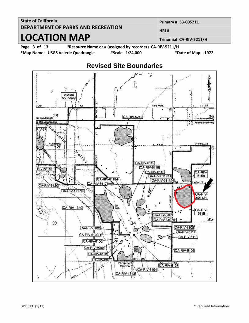
Page 3 of 13 *Resource Name or # (assigned by recorder) CA-RIV-5211/H
*Map Name: USGS Valerie Quadrangle *Scale 1:24,000 *Date of Map 1972
Revised Site Boundaries
DPR 523J (1/13) * Required Information
State of California
DEPARTMENT OF PARKS AND RECREATION
LOCATION MAP
Primary # 33-005211
HRI #
Trinomial CA-RIV-5211/H
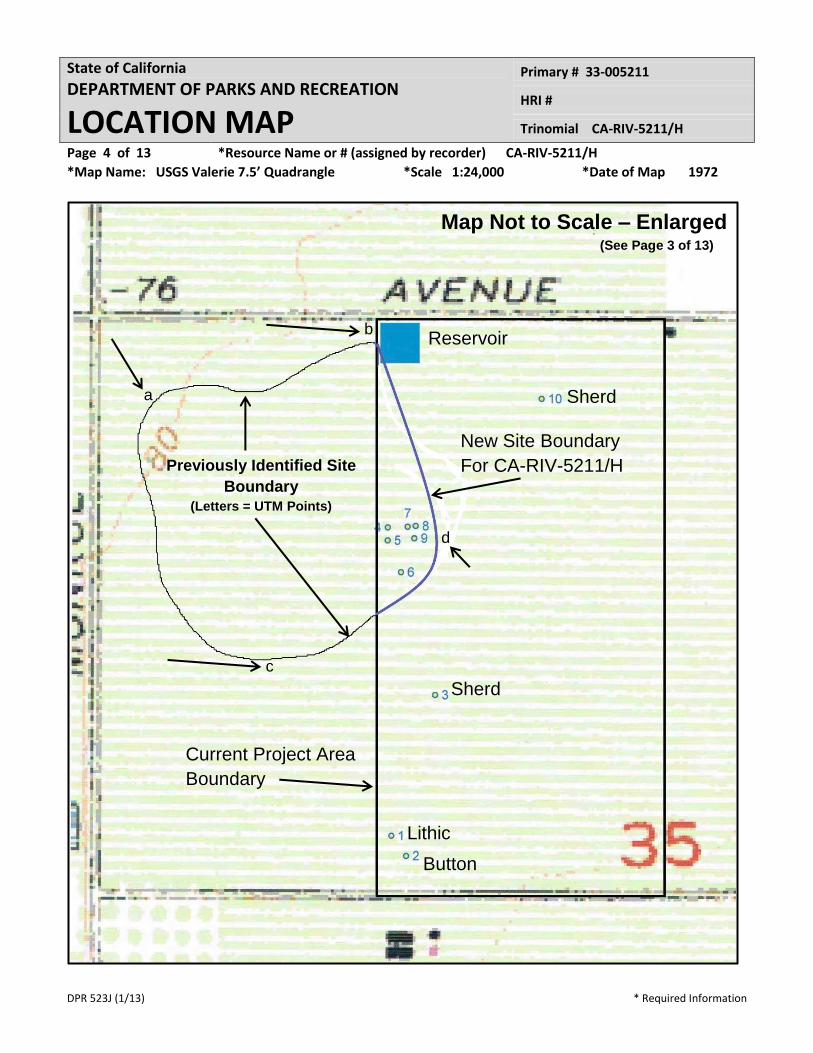
Page 4 of 13 *Resource Name or # (assigned by recorder) CA-RIV-5211/H
*Map Name: USGS Valerie 7.5’ Quadrangle *Scale 1:24,000 *Date of Map 1972
Current Project Area
Boundary
Button
New Site Boundary
For CA-RIV-5211/H
Lithic
Sherd
Reservoir
Sherd
a
b
c
d
Previously Identified Site
Boundary
(Letters = UTM Points)
Map Not to Scale – Enlarged
(See Page 3 of 13)
DP
R 5
23
L (1
/13
)
* R
equ
ired
Info
rmat
ion
Stat
e o
f C
alif
orn
ia
DEP
AR
TMEN
T O
F P
AR
KS
AN
D R
ECR
EATI
ON
CO
NTI
NU
ATI
ON
SH
EET
Pri
mar
y #
33
-00
52
11
HR
I #
Trin
om
ial
CA
-RIV
-52
11
/H
Pag
e 5
of
13
*R
eso
urc
e N
ame
or
# (a
ssig
ne
d b
y re
cord
er)
C
A-R
IV-5
21
1/H
(fa
cin
g N
ort
h f
rom
Ave
nu
e 6
1)
Re
cord
ed b
y:
Jean
ette
A. M
cKen
na
*Dat
e S
ep
t. 5
, 20
13
C
on
tin
uat
ion
X
Up
dat
e
DPR 523L (1/13) * Required Information
State of California
DEPARTMENT OF PARKS AND RECREATION
CONTINUATION SHEET
Primary # 33-005211
HRI #
Trinomial CA-RIV-5211/H
Page 6 of 13 *Resource Name or # (assigned by recorder) CA-RIV-5211/H
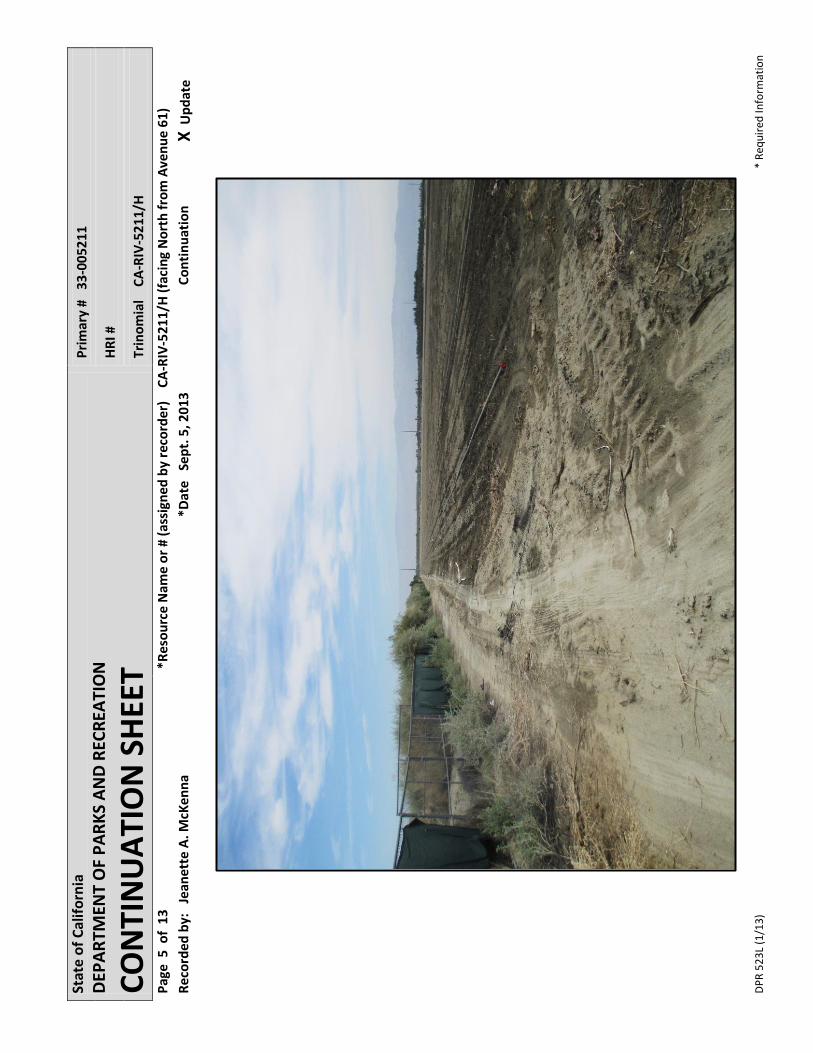
Recorded by: Jeanette A. McKenna *Date Sept. 5, 2013 Continuation X Update
Site CA-RIV-5211 is located directly west of the project area – mapped to the property boundary
between the current project area and the property to the west. This site was originally recorded
by Gallegos in 1981 and described as a disturbed site located within a plowed field. The arti-
facts included 28+ ceramic sherds, one mano, and one piece of fire-affected rock. The areal
extent of the site was recorded as covering 244 square meters.
In 1998, Love completed an updated record reporting the site to cover 440 meters by 315 me-
ters (138,600square meters) and consisting of a 30 acre area yielding 500+ ceramic sherds,
chipped stone artifacts of various lithic types, several manos, hammerstones, a pumice abrader,
three projectile points, and a centralized a living service. No human remains were identified, but
reported as “possible.” This site was tentatively dated to A.D. 1650 and the last recession of the
Lake Cahuilla shoreline.
Summarizing Hogan (2013), Demcak and Wade tested CA-RIV-5211 in 2005 and determined
the site was a significant resource. They recommended an archaeological monitoring program
during proposed development activities. Applied EarthWorks conducted the monitoring program
between September of 2005 and June of 2006. They completed their extensive report in No-
vember, 2010 (McDougall et al. 2010). Citing McDougall et al. (2010:8-9):
“In 2005, Archaeological Resource management Corporation (ARMC) was re-
tained by the Project developer … to conduct Phase II test level investigation at
CA-RIV-5211/H …[and] entailed a resurvey of the site area, and a 100 percent
surface collection of all cultural materials on the ground surface. Based on the dis-
tribution of the surficial artifacts identified, subsurface investigation consisted of
manual excavation of eight Shovel Test Pits (STPs) 50 to 75 Centimeters (cm) in
diameter and ranging in depth from 46 to 100 cm below ground surface (bgs),
eight 2 by 2 m Shovel Scrape Units (SSs) ranging from 10 to 20 cm in depth, and
seven 1 by 1 m Test Units (TUs) excavated to maximum depths of 50-100 cm bgs.
The STPs were excavated until a substratum sterile of cultural materials was en-
countered, while the TUs were excavated until two culturally sterile arbitrary 10 cm
levels were reached in succession, or when the unit reached recognizable lake-
floor (i.e. Lake Cahuilla) deposits. All sediments were screened through 3-
millimeter (mm) hardware mesh (Demcak and Wade 2005:14-21).
DPR 523L (1/13) * Required Information
State of California
DEPARTMENT OF PARKS AND RECREATION
CONTINUATION SHEET
Primary # 33-005211
HRI #
Trinomial CA-RIV-5211/H
Page 7 of 13 *Resource Name or # (assigned by recorder) CA-RIV-5211/H
Recorded by: Jeanette A. McKenna *Date Sept. 5, 2013 Continuation X Update
“Additionally, five trenches 3 m in length were excavated mechanically using a
backhoe with a 24-inch (in.) wide bucket to explore for deeper cultural deposits po-
tentially dating to the Late Archaic period. These trenches were excavated to
depths ranging from 150 to 156 cm bgs, and an estimated 10 percent of the exca-
vated sediment volume from the trenches was screened through 3 mm hardware
trench. The total volume of sediments sampled by the various types of manual
excavation units and mechanical trenches amounted to 20.2 m3 (Demcak and
Wade 2005:20-21).
“The Phase II investigations … resulted in the recovery of 150 pieces of lithic deb-
itage, 15 cores, nine flake tools, seven projectile points, five hammerstones, four
bifaces, three abraders, one core tool, four metate fragments, two mano frag-
ments, one Olivella biplicata wall disc shell bead, one modified bird bone, one
fragment of highly-calcined large mammal bone, and 1,437 ceramic sherds (Dem-
cak and Wade 2005:22-27, 38). Within the STPs excavated, cultural materials
were found at depths ranging from 15 to 61 cm bgs. The TUs yielded cultural ma-
terials from a minimum of 10 m to a maximum of 60 cm bgs, while cultural materi-
als were recovered to a maximum of 80 cm bgs within the trenches excavated.
Additionally, one subsurface cultural feature consisting of a discrete charcoal con-
centration associated with burned/oxidized sediments was encountered within the
profile of Trench No. 3 at a depth of 50 to 62 cm bgs (Demcak and Wade 2005:18-
21). According to ARMC, all of these cultural remains were encountered within the
two highly disturbed (i.e. from agricultural activities), uppermost strata (a root zone
and a plow zone) of sandy silty alluvium overlying a clay hardpan of lake floor de-
posits that was “encountered at roughly 50 cm below datum.” No midden-altered
sediments were encountered during testing (Demcak and Wade 2005:43). Upon
completion of the testing phase, the artifacts were turned over to the City of La
Quinta for curation.”
ARMC (Demcak) concluded the prehistoric deposits associated with CA-RIV-5211/H dated be-
tween A.D. 1000 and 1650 (based on diagnostic artifacts) and between A.D. 1260 and 1620,
based on carbon dates. Obsidian hydration dates indicated the potential for at least two sepa-
rate periods of occupation. ARMC made no mention of human remains.
DPR 523L (1/13) * Required Information
State of California
DEPARTMENT OF PARKS AND RECREATION
CONTINUATION SHEET
Primary # 33-005211
HRI #
Trinomial CA-RIV-5211/H
Page 8 of 13 *Resource Name or # (assigned by recorder) CA-RIV-5211/H
Recorded by: Jeanette A. McKenna *Date Sept. 5, 2013 Continuation X Update
Applied EarthWorks, Inc. conducted their monitoring program over the course of almost ten
months. This monitoring program included the physical monitoring of all grubbing and surface
vegetation removal, removal of agricultural features (i.e. irrigation features), the relocation of ex-
isting utilities, and mass grading of the property. McKenna et al. was able to acquire a portion of
this report from an outside source. McDougall et al. (2010:xxi-xxii) state:
“Site CA-RIV-5211/H was previously determined eligible for listing on the Califor-
nia Register of Historical Resources (CRHR) under Criterion 4, because the data
potential of the sire has made a significant contribution to understanding the broad
patterns of California’s history and cultural heritage (Demcak and Wade 2005:55).
The archaeological deposits that were identified during archaeological monitoring
of Project construction and emergency data-recovery excavations, which include
18 primary human cremation features; seven secondary human cremation fea-
tures; three canid cremations/burials; 53 primary burn pits; 11 secondary burn pits;
and two miscellaneous features, contribute further to the overall significance of this
resource. In total, 94 features were identified, and it appears that the majority of
the features and artifacts are associated with mortuary ceremonies, such as cre-
mation and the clothes burning ceremony, bu the Late Prehistoric and Protohistor-
ic Cahuilla Indians. Thus, the data indicate that CA-RIV-5211/H served as a tul-
wenive or niskicweniva, or place of cremation, possibly for the Cahuilla clans that
resided at the village of Mauulmii (Toro), located approximately 0.5 miles (mi) to
the southeast of CA-RIV-5211/H. There is little to no evidence that the site was
used for habitation purposes. Absolute and relative chronological data obtained
from CA-RIV-5211/H indicates that the sire was used between A.D. 1400 and
1800.”
Based on the data obtained from the Applied EarthWorks, Inc. report, the potential for additional
components of CA-RIV-5211/H are likely to be present within the property adjacent to the east
(the current project area), in both a surface and subsurface context. The subsurface deposits
may extend up to one meter below the surface and multiple periods of use may be present.
As previously presented, the current project area is located due east of CA-RIV-5211/H (the
eastern boundary of CA-RIV-5211/H is arbitrary and restricted only by a modern property
boundary). This project area is also due east or northeast of additional resources that, when

DPR 523L (1/13) * Required Information
State of California
DEPARTMENT OF PARKS AND RECREATION
CONTINUATION SHEET
Primary # 33-005211
HRI #
Trinomial CA-RIV-5211/H
Page 9 of 13 *Resource Name or # (assigned by recorder) CA-RIV-5211/H
Recorded by: Jeanette A. McKenna *Date Sept. 5, 2013 Continuation X Update
mapped collectively, are indicative of a relatively large prehistoric and/or protohistoric use area
that has been described as a cemetery/crematorium associated with a large and significant Ca-
huilla village (Toro). All of the reported resources are located near the 80 foot contour line, sug-
gesting they were along the shoreline of Lake Cahuilla during the Late Prehistoric time period.
With the knowledge that the current project area is highly sensitive for the presence of additional
resources associated with CA-RIV-5211/H, McKenna et al. conducted the field survey on an in-
tensive level (less than 10 meter intervals) and used the current disking rows as a means of in-
suring controlled coverage. The survey was initiated at the southwestern corner of the property
with north/south transects and proceeded west to east. The frontage of the property adjacent to
CA-RIV-5211/H was marked by the presence of a construction fence and a dirt access road.
At Avenue 60, the property is nearer the identified boundaries of CA-RIV-5211/H and CA-RIV-
5158 (north of Avenue 60). The modern reservoir is also due east of CA-RIV-5211/H and was
already present at the time of the data recovery at CA-RIV-5211/H. The soil berm constructed
around the reservoir was examined for any evidence of prehistoric materials. Small shells as-
sociated with the lake shore were identified, but no artifacts were found in the general vicinity of
the reservoir or along the fence line between the reservoir and the fence line.
One lithic artifact and a minimum of eleven prehistoric sherds (8 loci) were identified within the
project area. More specifically, McKenna et al. recovered eleven sherds, but left an additional
very sparse scatter of very small sherds in the field (less than ten additional sherds identified).
Of the eleven sherds recovered, nine were found south of the reservoir and the remaining two
were from an area east of the reservoir. The majority of these sherds were found in close prox-
imity to the western property boundary (nearer CA-RIV-5211/H). It is noted that the sherds rec-
orded during this study were all surface finds and only slightly larger than the proverbial “thumb-
nail.” McKenna et al. did identified additional fragments of ceramics within the disked field, but
these were less than one centimeter in size and, while noted, were not collected.
The majority of the sherds identified within the project area were standard Tizon Brown sherds.
These brown ware sherds were all body fragments (no rim sherds) and relatively small. There
were no distinguishing traits to identify the vessel type. None of the sherds exhibited any post-
production burning or alterations (other than the shatter). These items were likely moved by the
years of agricultural activities, but given the small sizes, they were probably not moved too far

DPR 523L (1/13) * Required Information
State of California
DEPARTMENT OF PARKS AND RECREATION
CONTINUATION SHEET
Primary # 33-005211
HRI #
Trinomial CA-RIV-5211/H
Page 10 of 13 *Resource Name or # (assigned by recorder) CA-RIV-5211/H
Recorded by: Jeanette A. McKenna *Date Sept. 5, 2013 Continuation X Update
from an original location. Photographs of the single lithic and various sherds are presented in
Appendix E and, summarized here, the artifacts are identified as follows:
Artifact No. 1: Lithic
Artifact No. 1 is a small fragment of rhyolite, roughly triangular in shape and exhibiting two
“points” that appear abraded. This item was likely used as a stone awl or punch, but not manu-
factured as a formal tool. Measuring 4.8 cm x 3.0 cm x 1.5 cm, this item was recovered from an
area near Avenue 61 and the southwestern corner of the property and near the location of the
shell button (Artifact No. 2; discussed previously). The UTMs were recorded and this item was
recovered and will be prepared for curation.
Artifact No. 3: Ceramic Sherd
Artifact No. 3 was identified by UTM coordinates in the central portion of the western half of the
property. This sherd is a relatively thin Tizon Brown body sherd measuring 2.9 cm x 2.6 cm x
.4 cm. There were no marking on this sherd and no other items in the immediate vicinity. There
is no evidence of burning.
Artifact No. 4: Ceramic Sherd
Artifact No. 4 is another Tizon Brown sherd with a slight reddish interior. Measuring 5.1 cm x
4.4 cm x .5 cm, this item was recovered from an area of a small cluster of sherds and mapped
via UTM coordinates. This item shows no signs of recent breakage and the edges are weather
worn, suggesting it was broken long ago. There are no diagnostic attributes. There is no evi-
dence of burning.
Artifact No. 5: Three Ceramic Sherds
Artifact No. 5 is actually represented by three small ceramic sherds recovered from an area of
approximately 4 square meters. Two are identified as Tizon Brown sherds and the third (small-
est) is a Tizon Brown with a red interior. The largest measured 3.1 cm x 1.7 cm x .4 cm. The
mid-sized sherd measures 2.4 cm x 1.8 cm x .5 cm. The smallest sherd is 1.9 cm x 1.3 cm x .3
cm. All three sherds are weather worn and show no evidence of recent breakage. There is no
evidence of burning. UTM coordinates were recorded and the items collected.

DPR 523L (1/13) * Required Information
State of California
DEPARTMENT OF PARKS AND RECREATION
CONTINUATION SHEET
Primary # 33-005211
HRI #
Trinomial CA-RIV-5211/H
Page 11 of 13 *Resource Name or # (assigned by recorder) CA-RIV-5211/H
Recorded by: Jeanette A. McKenna *Date Sept. 5, 2013 Continuation X Update
Artifact No. 6: Ceramic Sherd
Artifact No. 6 is a small brown ware sherd with a reddish finish (slip). Measuring only 1.6 cm x
1.5 cm x .4 cm, this small fragment was identified by UTM coordinates and collected. This
sherd is further fragmented, having lost some of the surface on one side. No distinguishing el-
ements were identified. There is no evidence of burning.
Artifact No. 7: Ceramic Sherd
Artifact No. 7 is another small sherd identified as a brown ware with a red interior slip. Measur-
ing 2.7 cm x 1.9 cm x .6 cm, this small sherd was identified at UTM coordinates and collected.
There were no distinguishing characteristics and the item was too small to suggest vessel type.
There is no evidence of burning.
Artifact No. 8: Ceramic Sherd
Artifact No. 8 is an irregularly shaped Tizon Brown sherd measuring 3.4 cm x 1.5 cm x .6 cm.
Identified at UTM coordinates and collected, there were no distinguishing characteristics and the
item was too small to suggest vessel type. There is no evidence of burning.
Artifact No. 9: Ceramic Sherd
Artifact No. 9 is a triangularly shaped brown ware sherd measuring 3.7 cm x 3.0 cm x .8 cm.
Variation in the thickness of the sherd suggests this fragment may be a portion from an area
near the base (but not the base). Identified at UTM coordinates and collected, there were no
distinguishing characteristics and the item was too small to suggest vessel type. There is no
evidence of burning.
Artifact No. 10: Ceramic Sherd
Artifact No. 10 is actually represented by two sherds recovered from an area of approximately
four square meters. The smaller sherd is similar to others recovered from the property – brown
ware with red slip, but no distinguishing markings. This sherd measured 2.2 cm x 2.0 cm x .5
cm. These two items were recovered by UTM coordinates as a single point. The second item
was markedly different than the others. It was identified east/southeast of the reservoir (not
near the reservoir) and separated from the other pieces of ceramic both by location and type. In
DPR 523L (1/13) * Required Information
State of California
DEPARTMENT OF PARKS AND RECREATION
CONTINUATION SHEET
Primary # 33-005211
HRI #
Trinomial CA-RIV-5211/H
Page 11 of 13 *Resource Name or # (assigned by recorder) CA-RIV-5211/H
Recorded by: Jeanette A. McKenna *Date Sept. 5, 2013 Continuation X Update
this case, the sherd was identified as a thick buff ware with measurements of 6.6 cm x 4.2 cm x
.8 cm. The nature of the sherd suggests it was from a relatively large vessel, but no other frag-
ments were identified to verify the vessel style.
Found with the interior face-up, McKenna et al. was surprised to find the exterior of this buffware
sherd exhibiting a textured surface consisting of a symmetrical series of small, circular indenta-
tions. Without the soil encrusted on the sherd, the decorative elements are not as overt. With-
out additional data, McKenna et al. is tentatively identifying this sherd as a Salton Buff ware and
it may have had some specialized use, given the surface decoration.
Similar sherds may be within the collection from CA-RIV-5211/H, but this will require verification.
There is no evidence of this piece being burned and there were no other fragments in the area
to suggest this sherd is within an area that will add to the collection. To date, this is a rather
unique piece, but not necessarily as significant piece, lacking the necessary archaeological con-
text for evaluation.
Summary of Prehistoric Archaeological Resources
The recent field investigations resulted in the identification of twelve prehistoric artifacts at nine
locations (including one lithic artifact and eleven sherds), no features, and no evidence of any
human remains. Some additional small fragments of ceramics were also noted, but not recov-
ered. The surface was intensively surveyed and the artifacts summarized above were found to
occur in three contexts:
A) A small cluster of sherds was identified in the area mid-way between the reservoir and Avenue 61; near the western boundary of the property near the mapped east-ern boundary of CA-RIV-5211/H; and
B) The decorative buff ware sherd was found in a more isolated area east and south-east of the reservoir and further away from the area associated with CA-RIV-5211/H.
McKenna et al. cross-referenced the various artifacts by NAD 83 UTMs and extended the east-
ern boundary of CA-RIV-5211/H to reflect the addition of the sherd scatter identified during the
recent survey.

DPR 523L (1/13) * Required Information
State of California
DEPARTMENT OF PARKS AND RECREATION
CONTINUATION SHEET
Primary # 33-005211
HRI #
Trinomial CA-RIV-5211/H
Page 13 of 13 *Resource Name or # (assigned by recorder) CA-RIV-5211/H
Recorded by: Jeanette A. McKenna *Date Sept. 5, 2013 Continuation X Update
UTM Coordinates Cross-Listing
NAD 27 Readings NAD 83 Readings
Point Easting Northing Easting Northing
Artifact 1 571921 3718591 571619 3718784
Artifact 2 571642 3718563 571640 3718756
Artifact 3 571681 3718786 571679 3718979
Artifact 4 571614 3719018 571612 3719211
Artifact 5 571613 3719000 571611 3719193
Artifact 6 571633 3718956 571631 3719149
Artifact 7 571642 3719019 571640 3719212
Artifact 8 571653 3719020 571651 3719213
Artifact 9 571651 3719003 571649 3719196
Artifact 10 571827 3719197 571825 3719390
Site (a) 571270 3719160 571268 3719353
Site (b) 571580 3718280 571578 3719473
Site (c) 571470 3718800 571768 3718993
Site (d) 571695 3719016 571693 3719209