Embed Size (px)
Citation preview

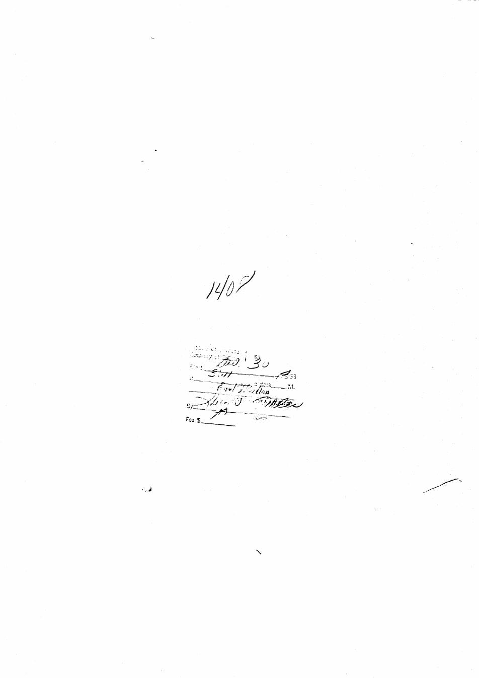
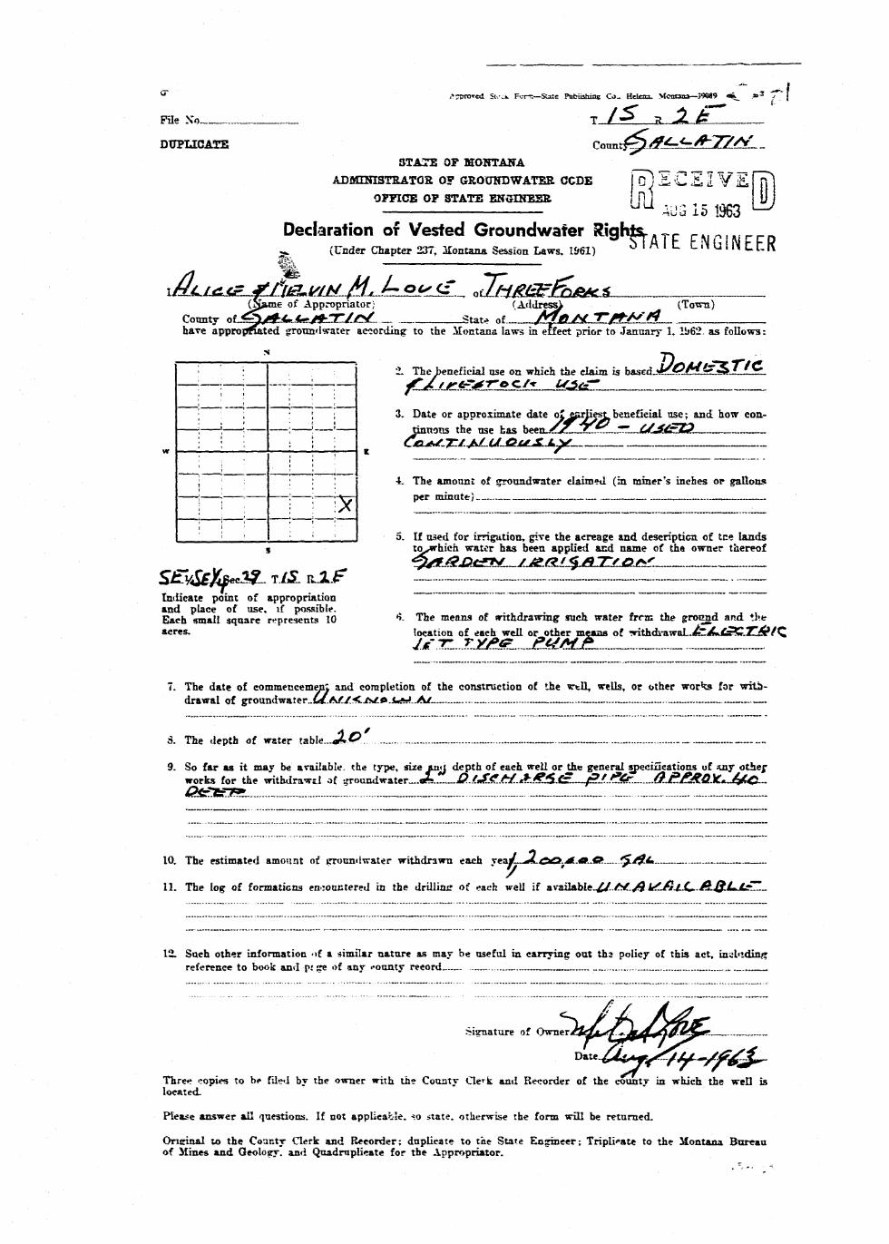
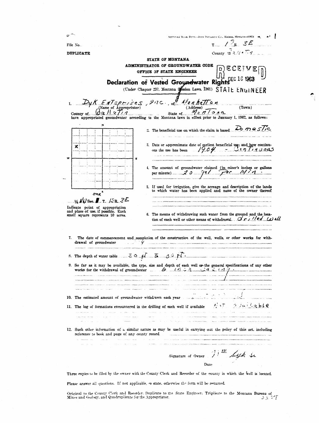
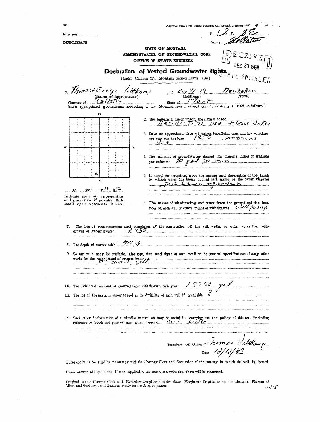
" A^i-iu>Jd Stcdc F^rn-—SLite ."mblishin* Co- Hciea. Muntaaa— 5SM7 o i j>3 '"7 ,- ^I^^H
File Xo.._ T__1S R....2E ^ ^ H
DUPLICATE Countr-5«llatill ^ ^ BSTATE OF MONTANA ^ H |
ADMTKISTRATOB. OP GBOTJHDWATEB CODE fg^ "£ £ E i " / E Hf l ^ ^ BOFFICE OF STATE EKGIHEER {ft I _ „ ^ ^ J j j ^ ^ B
^ ^ Oc.c 1"* 1963 ^ ^ HDeclaration of Vested Groundwater Rights c f F p ^ H
(Under Chapter 237, Montana Session Laws, 1961) 3 I A I L. l_ N U I N 1 1 K ^^M
l- Yer* B. Ecton _ _ nf P . 0 . Boac 517. Bosenan ^ ^ B(Name of App>-opriator; (Address) (Town) ^ ^ ^ H
Connty o£ Gallfttln. State of.__.__MonjMttlft ^ ^ Bhare appropriated crroundv-jiter according to the Montana law= in effect prior to January 1, 1962, as follows: ^ ^ ^ H
i—5—-——i , H* : : 2. The beneficial use on which the ciatm is *••"?'"* 7^'nfft^t'i.C ttlUa ^Hj^H
—: . ;— «LtOC.k _ HH' . - : 3. Date or approximate date of earliest beneficial use; and how con- ^^^^V• • : : ' tinuous the use has been-A911u. .a^. . .«S^l^ljLJf |^_JII« ^HH
w —i—:—:—'—:—:—;— E __ 1_ | ^ l; ; , : • 4. The amount of groundwater claimed (in miner's inches or gallons ^ ^ ^ ^ |; 1 ; i ; j p:r minute i ^ 0 8 * 1 1 * * ^ p*1T ""f*1"^ ^ ^ ^ B
1 '< '< : • • I 5. If used for irrigation, give the acreage and description of the lands fl^^H
s to which water has been applied and name of the owner thereof ^ ^ ^ HJ^.JMMO<^i£dtgfif&9R* HI
KE i4.1»^ecl2... T.1S. R2E-. — - ^ HIndicate point of appropriation '" ~ ~ ^ ^ ^ Hand pia:e of use, if possible. I^^^BEach sma»I square represents 10 6. The means of withdrawing such water from thr ground and the ^ ^ ^ Bacres. location of each well or other means of withdrawal™ fl^^H
jBrjyMEttfla-u^jcjLs^^R^^.!-..!! z _ HH
7. The date of commencement and completion of the construction of the well, welb, or other works for with- I^Hldrawal of groundwafer...l.9U - — — ^^^^B
8. The depth of water table. Z 0 0 . f © « t . _ _ _ ^ ^ ^ B
9. So far as it may be available, the type, size and depth of eacL well or the general specifications of any other ^ ^ ^ Hworks for the withdrawal of trrnirn wntpr D r i l l e d l t e l l J 6 fru. /»a»f^g_ ft^fl fffft* dfffp ^ ^ ^ H
10. The estimated amount of groundwater withdrawn each year AppTgort^T^^iy A0OyQ0O g a l . ^ ^ ^ H
11. The leg of formations encountered in the drilling of each well if available &^y^ -ttf|F gfflll GTtA ^ ^ ^ B'•ocky fflTTn irtfflnff L — - ._ ^^^B
12. Such other infonnatiou of a similar nature as may be useful in carrying out the policy of this act, including ^^Hji 1
reference to book and page of any county record TVwrffi — ._. ^ ^ ^ ^ B
Signature of Owner •.. ..TT....."..-' -r. ....' ,4-wr?w ^ ^ ^ ^ B
Date D«c«ab«r 12, 1963 ^ H
Three copies to be filed by tb»* owner with the County Clerk and Recorder of the county in which the well is ^ ^ ^ B llocated. ^ M
^^BPlease answer all qc?stions. If not applicable, so state, otherwise the form will be returned. ^ ^ ^ B
Orieinal to the Countv Clerk and Recorder: duplicate to the State Engineer: Triplicate to the Montana Bureau ^ ^ ^ B

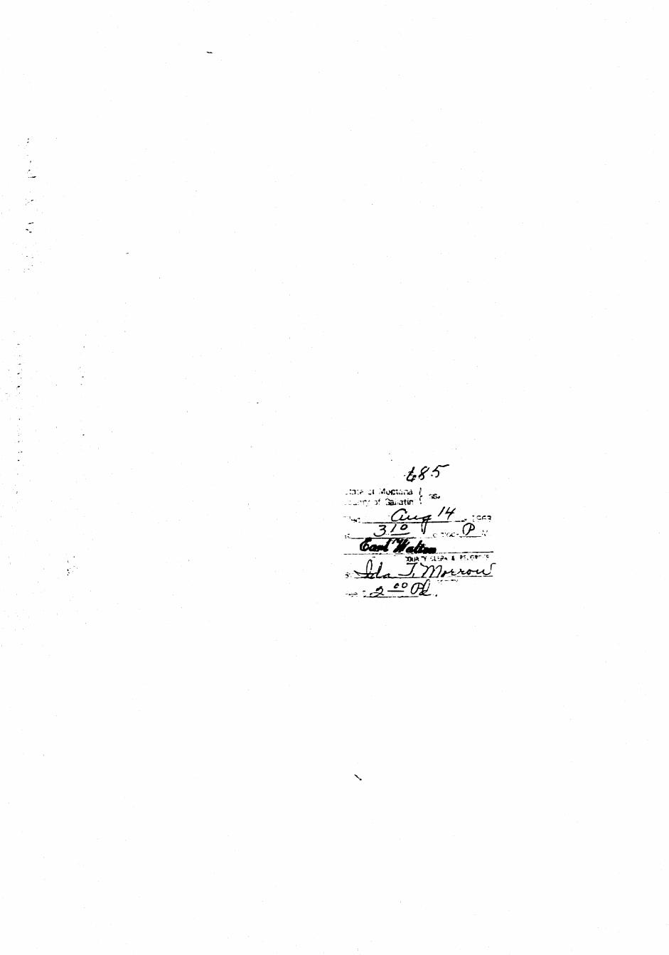
a 7
Stata of MrjnUftf )County of GaHatin J
Cjtari S^Jt C* .- / (•» . TOCT ^
iezOMenBy iP1'. ^JJ^-.
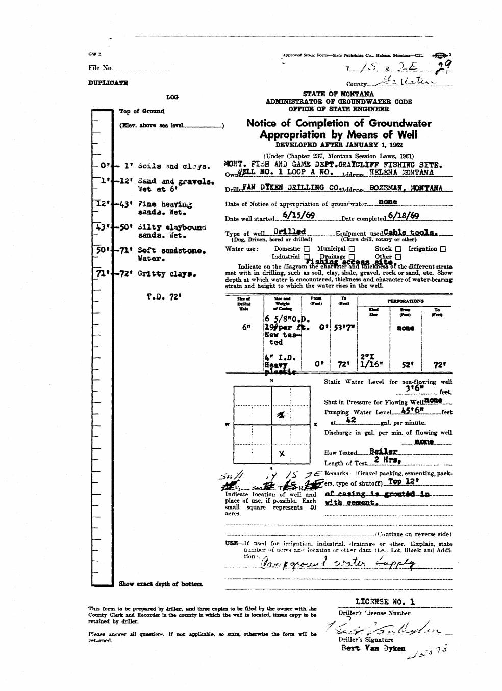
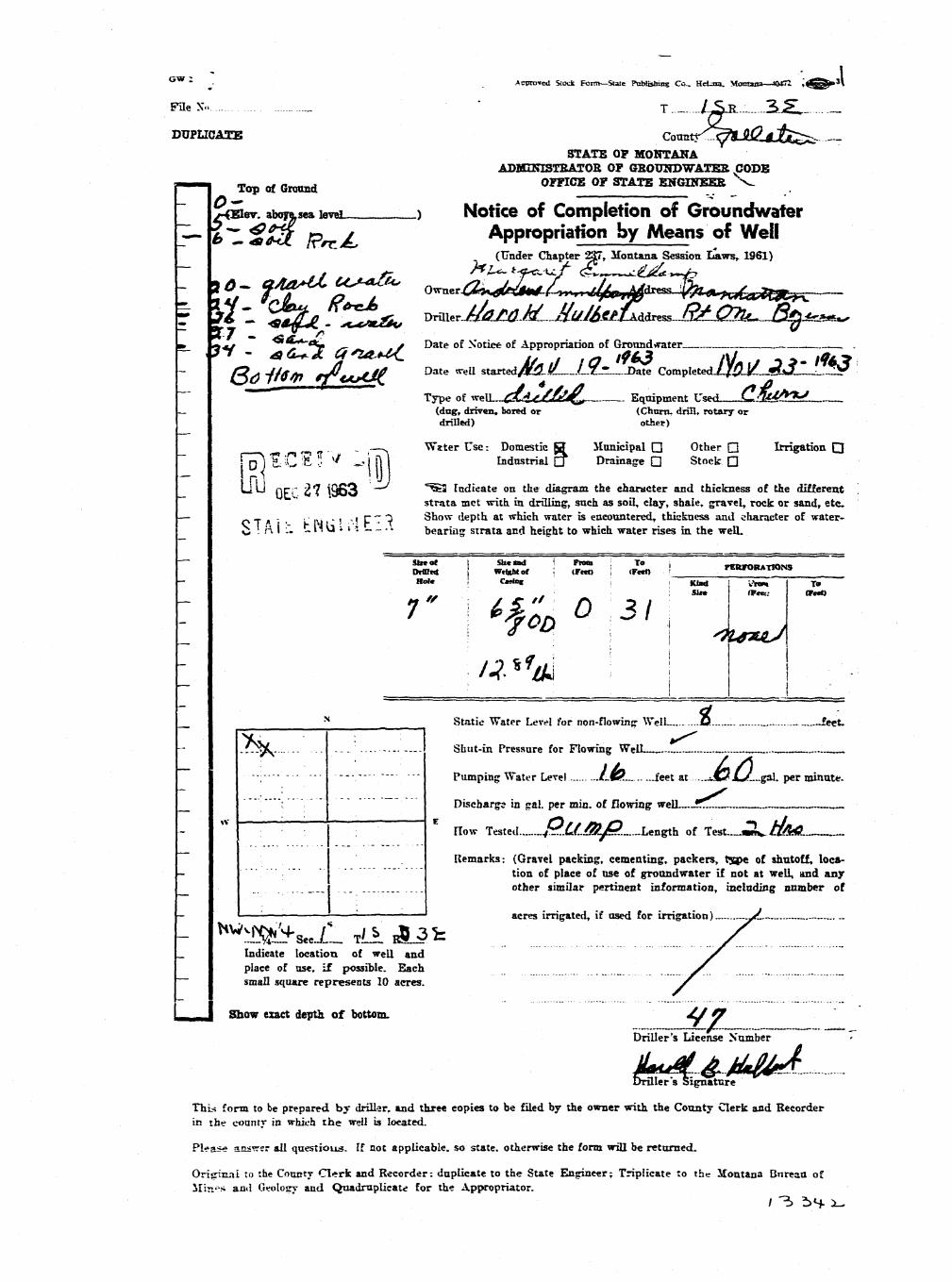
GW I \ppnjnd Stock. Form—Suie Publisbia? Ca_ K±£=. if~»»a»—t56C jsV» 3 H ^ H ^ I
File No ' " ' " T _ Z H _ _ . _ B J L £ " . fZ- ^ ^ B
DUPLICATE " r.>Tmty Gal lat in BflVB- ESTATE OP MONTANA ^ H
" * * ADMUTTSTKATOR OF QBOUNDWATER CODE • _ •( — I Top of Qnnmd " OFFICE OF STATE ENGINEER ^M
(Eter. above sea leveL iZ.) Notice-of Completion of Groundwater ^ B~ Appropriation by Means of Well B H- 0' > 2dT Qlay eafeAuUd with "DEVELOPED AFTER JANUARY I, 1962 ^ H— b r o k e n Z*ck* D r y (Under Chapter 237. Montana Session Laws, 1961) ^ ^ H
* * Date of Notice of appropriation of groundvrater ^M.^ ^ ^ ^ 1
210' .355* ^ark blua a^lea, ^ « u rtlrted_0et2_a^ Date• eo^^LOsShJSM H— ao j - j a i a . JTy* ^ I ^ B ._ _ _ . , „ _ . , . , , . Tvpe o.C well ^CLll&l Equipment nsed fifldbaZ^*' ^HV7 5 5 f - 'v23 f UarK OlUft n.tTd ' (Dug, drww. bored or driUed) (Chtnn driH. rotuj or otter) ^ ^ H— S h n l f t t i d t h a f «W VTater use: Domestic • ilunieipal Q Stock 6 Irrigation n fljH_ K ^ l l SSKvl l e n s a a . Industrial n Drainape Q Other Q ^ H
Froa 35$' to 365* ^^H*Ktt «»-i«f» --. i -. T 4 «-*.i - Indicate on the diagram the character and thickness of the different strata ^ ^ ^ Bt a e Srma ^ J a X a . & * ^ ^ ^ ^ drilling, such as soil, clay, shale, gravel, rock or sand. etc. Show ^ ^ B
_ CO aTSer Mii&n. ft depth at which water is encountered, thickness and character of water-bearfcg ^ ^ H£%M p e b b l e s • strata and height to which the water rises in the well. ^ ^ ^ B
~_ T.D. 422« 7 T / ^ 6 5/S" ! 0« 422« 1/16"! 322 (•22 ^ H' 0.0. , : : x i ^ O
i ^r i6" j •— ' : i ^ H— " Static Water Level for non-flowing well H ^ H
j — | j 1 . W ' feet. Wk: Shut-in Pressure for Flowing WelL-JUSMU. ^ ^ H
_ : Pumping Water Level sCE? feet ^ ^ H
w c at .<§ gal. per minute. ^ ^ ^ H
'• Discbarge in gal. per min. of flowing well ^^^H
~ }C ; ; How T«ted_.A4?J&!&#.._ — _. ^ H~ I 1 1 ! Length of Test ? .JUTS. ^ ^ B— Remarks: (Gravel packing, cementing, pack- B^HJ
w/zG,, it, * ,c „-,£- ers, type «»f shtttoff).V^^«r_J5S*_J H
place of use. if possible. Each Bdl tOTi i t e* B H H— small square rt-presents 40 ~ " ~ ^HHJ
aeres. _ ^^^Ba
.Continue on reverse side) ^HHJ
USE—If used for irrijratii n. industrial, drainage or other. Explain, state HHHj_ Qumb»r of acres and location or other data (i.c.: Lot. Block and Addi- ^H^H
tion). ^ ^ ^ H~ R«if« veilLi_«^.;t^._water..is...l*?«:I for ^ H~ . cafetle. irtnkint* _ ^^BM B ^ J Show exact depth of bottom. ^ ^ H
Lie.: .r c. i ^ BThis form to be prepared by driller, and three copies to be filed by the owwr ••vi:h ;he ZT~~~,"~~~~'. TZ 7~ ^ ^ ^ HCounty ae rk and Recorder in the county in which the well is located, tissue copy to be Dnl l - r s Li<vnso Number ^ Hretained by drillei. / ^ ^ ^ B
• - • - ' ^ • - -^ • - B^BPlease answer aii questior.5. If aot applicable, so rta;-!. other»i?e -.he f<.'rrr. -tr." b^ -- —• • •returned. DrilU-r's Signature. ^ B H

J o * * • } -
State of Montana ) ^County of Gallatin »
3t ^9:*.* ^ . ..•fdoclAM.
*.^2!LJE.

c * • ^pptcrert--trek Font.—State PobUshias Co_ HeSena. Montana—C^-i a ^ ^ ^ - t ; l ^ ^ ^ ^ B
pae No T I S JL ._ X K j^H
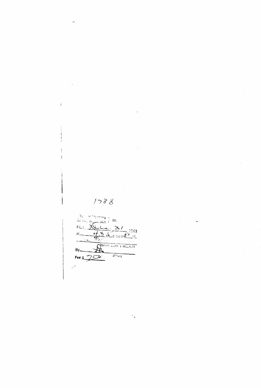
DUPLICATE Coanty_jSallajri*l H^B
STATS OF HQNTAKA ^MeTjaa House fl^BADMDnSTRATOS OF GBCUNDWATEB. CODS "™"~~" ^S5
OFFICE OF STATE ENGINEER l ^ B• ^ — — — — — — — — — — — — ^ \jt\.\ _*_ "-• j-»•<-•? ^ ^ H ^ B
Declaration of Vested Groundwater Rights ^ B ^ l(Under Chapter 237, Montana Session Laws, 1961) ,.: fl^H
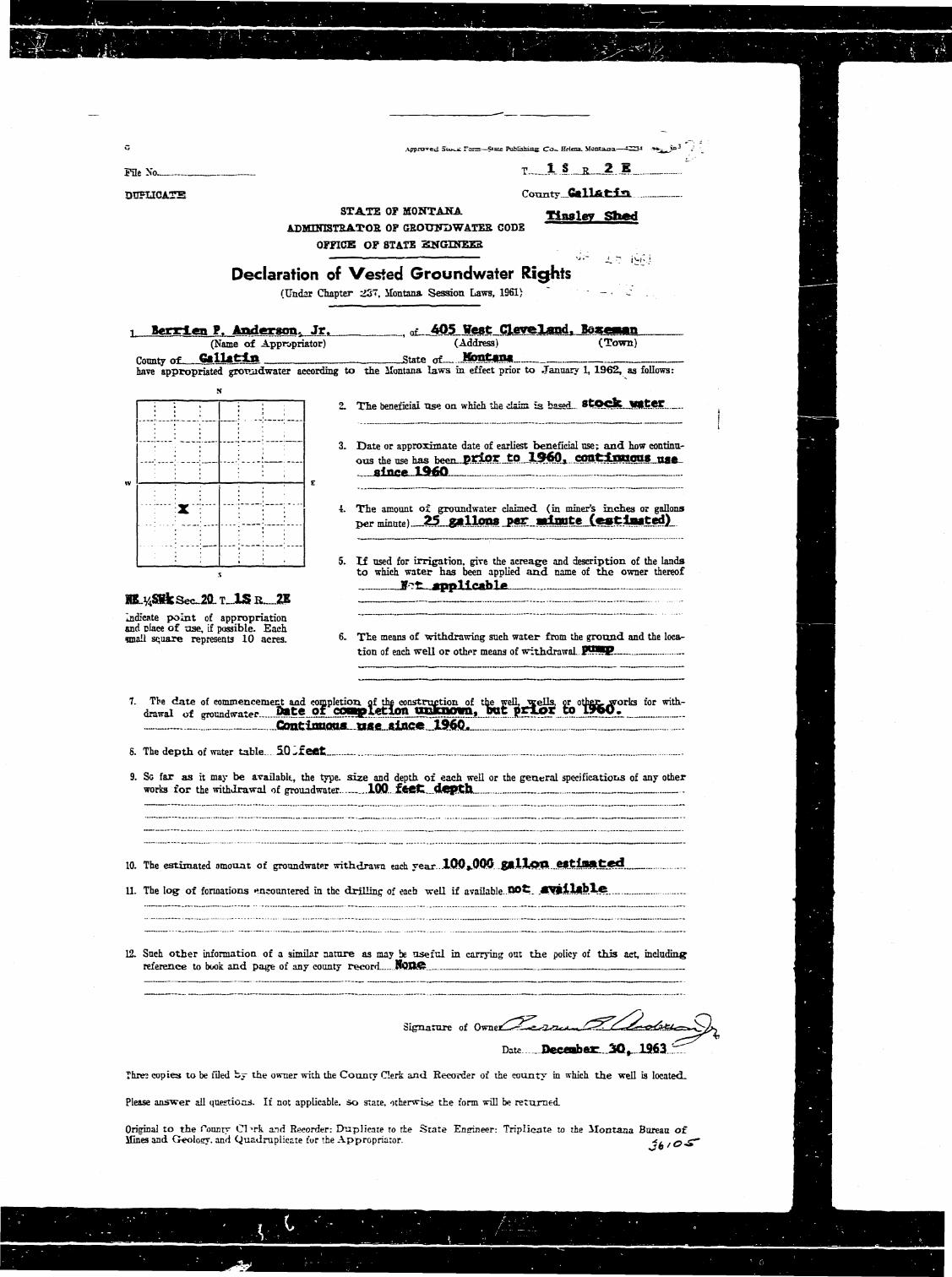
3—nygu^KPfi p A|mgp«sogt jg,, , of—405 ¥ * * t Cleveland Bcgcrf**— ^ H |(Name of Appropriates) (Address) (Town) S^^S
County oi-__SaUAtia _ state of Mmi&am W B Bhave appropriated ground-water according to the Montana laws in effect prior to January I, 1962,. as follows: HB^H
: ; ; . ; 2. The beneficial use on which the claim is li i iiiTlifWHrir IIHI, ^ ^ ^ n
: j . ; 3. Date or approximate date of earliest beneficial use; and how contdnu- jHBHB-—: — —' — ; ous the use has been .pdoE~tO -I960-.... Con£in90U8 ^ ^ ^ H
; . ngfr gincff l fiO - _~ - _ ^^^^Bw : i 1 ; : E _ _ „ B ^ K
; ' : : , ; ~ - - - • ^^^B: • : 4. The amount of groundwater claimed (in miner's inches or gallons ^^^^H
: ---! _ r » - " " " " ) ^^ g^*'''*fre T*** —< w w f '* •fM•^•^^d• ^ ^ H
: I • I 5. If used for irrigation, give the acreage and description of the lands ^ ^ ^ Hs to which water has been applied and name of the owner thereof ^ ^ ^ H
ffotr flppT 1***h *» ^ ^ ^ ^ K
SE^%JSasecl6L.T^lS.R2E_. I—! '. Z_Z_111.Z..Z""V 7 BBIndicate point of appropriation ^ ^ ^ Band placv of use, if possible. Each . ~ ^ | ^ Hsmall square represents 10 acres. - ^ e means of withdrawing such water from the ground and the loca- ^ H ^ H
tion of each well or other means of withdrawal ^ p u p ^ ^ ^ H
7. The date of commencement and completion of the construction of the well, wells, or other works for with- ^IHBdrawal of groundwater D>t.O o f I ^MI>1<1 Toil IllltlfcfWO, h'Klf OTTIJOT tO I 9 6 0 . ^I^H
. CoptlTOtirm m# stnc# X?60 ~ ^ ^ B
8. The depth of water table. 53 £o*£- «Stl3Atcd, — - - ^ ^ ^ B
9. So far as it may be available, the type, size and depth of each well or the general specifications of any other ^ ^ ^ Bworks for the withdrawal of 5froundwater -180- £Mt dttth i^^H
10. The estimated amoxmt of groundwater withdrawn each year 1QQ .000 gailfWl ff»1"fMBffd .. BI^H
1L The log of formations encountered in the drilling of eaca well if available Ho£ CVftUsbXct— H^BB
12. Such other information of a similar nature as may be usefnl in carrying out the policy of this act, including fl Breference to book and page of any county record SOQC ^ ^ ^ H
Signature of O^t^r^^kl?^^^.:^^^.^ ^ ^ ^ B
Date I>ece«b«r 30x 1963 ^ ^ B
Three copies to be filed by the owner with the County Gerk and Recorder of the county in which the well is located. ^HH
Please answer all questions. If not applicable, so sure, otherwise the form trill be returned. flUfl
Original to the County CVrk and Recorder: Duplicate to the State Enirinter: Triplicate "o the Montana Bureau of ^ ^ ^ ^ HMines ar.d <Ieolotrv. and Quadruplicate tor the Appropnator. B^^B
36/OJL ^ ^ H
t
t
I
I
i
j / : > ? £
'• w :.".. -•, . ' S3.
n^, ,
i
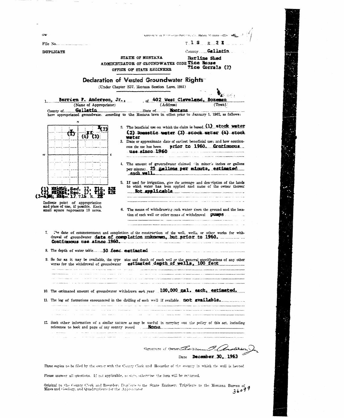
-—- / H ^ BFile No. T . I S 1 35 5. ' ^ ^ ^ H
DUPLICATE County GaljL&£itl - 1591STATS OF MONTANA Hurline Sked • • « •
ADMUCSTRATOK. OF QEOUNDWATEE CODE f i e © B a s s e SHEOFFICE OF 8TA.TE EHGDrEEE ^ l c « Corra l s ( 2 ) US|
Declaration of Vested Ground water Rights mQ(Under Chapter 237, Montana Session Laws, 1961) fl^Bi
x Berrign P. Anderson, Jr., nf 402 Weas Cleveland,, Borgaan B B H(Name of Appropriator) (Address) (Town)' ^ IR
Comity of €a.X2ASi£L State of. HcHfttOTa „ ^ Hhave appropriated groundwate:-- aceordirg to the Montana laws in effect prior to January 1. 1962. as follows: 1 R5
• : '• '• i ^ 0 % " ' ^ i l e beneficial use on which the claim is based_\JX_*?Q«. WfttOT j^BBI1 *ify -->xir ^^ 42) ftMUSfcic water (3> »to<^ ««t«r (4> otock HH
M w/L. w»ter HB•""" '• '•' ~ ' • : " . * 3. Date or approximate date of earliest beneficial use: and how eontinu- H ^ ^ H
— ;—:.—: .--: :-— otts the use has been. p r i o r tO I 9 6 0 . CCHtiJHXOa8 _ HH• : ut* «ixiea 1960 — H S R
»v I : : 1 : ; : 1 E _ R B ^ H: : '"; : ; 4. The amount of grotradwater claimed fin miners inches or gallons ^ H H I-. - -; : —- - —: - - - per minute) _ 25 ^allOIta p«TT u l n » t a » . ©Sttflttt<?d...^_ jH
; : • • j^gch W a l l . _ „ H B B B: : • : : 5. If used for irrigation, give the acreage and description of the lands IH^B
/ « v , — I H . I _ t i-j «n- . «<«« to which water has been applied and name of the owner thereof ^ ^ ^ ^ B
viLXBkfl& ": m\ m --- ifotjqwdifi«bie. _ „. . M B<3^JC3iS«:
tiFTis..k...H ....- - - nIndicate point of appropriation -—— - ^ ^ ^ H |and place of nse, if possible. Each ^I^Hsmall square represents 10 acres. 6. The means of withdrawing i-uch water ironi the ground and the loca- B^^B
tion of each well or other man* uf withdrawal pUM^S . .. S S ^ H
7. r*ie date of commencement and completion of the construction of the well, welLi. or other works for with- ^^BHdrawai of groundwater date o£ coopletion miia»c3«n» htj pr ior to 1360* ^ ^ B
8. The depth of water table... 50 -£eec estimated ^I^K
9. So far as it may be available, the type 3ize and depth of each well or the general specifications of any other ^ ^ ^ Bvraria for the withdrawal of groondwater eStiSWIted . .4.^. th_of_J»lla^._lw_fe2t:__ B ^ B
10. The estimated amount of groondwater withdrawn ea^a year ... !OQtOOO._gH.l.....fKICfcx...®*?iBiitCd, • ^ ^ 1
11. The log of formations encountered in the drilling of each weLI if available. QO£ flVftLJUtblfis. ^ ^ ^ B
12. Such other information of a similar nature as may be useful in carryinr: oat the policy of this act. including ^Hflreference to book and pace of any county rreord . JSoUt^. ^ ^ ^ ^ B
Date Seceotber3Q+ 19W ^ ^ B
Three wpies t«"> be filed by the owner with the Ci>ur.tr i"lerk ar.d Recorder of th«? coitn:y in ^vhieh thr- v?e'i\ Ls loenter! B ^ ^ H
Please answer ail 'inestions. If r.ui applicable, so <;;•:". othi'r'.'"isp the form will bo re'nrned. ^ ^ ^ ^ H
Oriirinal to rhf i^iLnty Cork :\r.<\ Rmnipr-. D-ipiVnv '« the J^tate Ensrineer: Trip'ier.tf- to th*: Montana Buran of * I^^^BMines a n d < leolocy. and Qisadrripiii-ate f«>r t h e Aripr^:.: -!:>!.>r ~* Lotf j ^ ^ ^ ^ l
' ' •••-• - ..A*- ' ^ ^ — ^ / - 1 9 5 3
^ariSfefcg
^ Approves; 5ux_£ ram—S*«e Publishing Co.. Helena. Montana—-2Z3-* -a**^ j»^ u: ^ ^^^^^^H
F n e N o ^ _ _ _ T l.?.._JJ 2 .E . HH
DUFUCATE Connty.jG«llftJfci£L ^ ^ H
STATE OF MONTANA TtaslCT Shed | HADMUnSTEATOB OF GBOTTNDWATEB CODE |BH
OFFICE OF STATE HNGINEES ^ ^ ^ K
Declaration of Vested Groundwater Rights HH(TTndar Chapter 237, ilontana Session Laws, 1961) - c . j ^ ^ ^ B
T Berrt.cn P. Anderson, Jr. , 0T- 405 West Cleveland, Boge—n | ^ H(Name of Appropriator) (Address) (Town) ^ ^ ^ B
County of GlllatjLn State of JiMSt-iS* | ^ ^ Bhave appropriated groTuidwater according to the ilontana laws in. effect prior to January 1, 1962, as follows: *_V_V|
i '. i j ' 2. The beneficial TXSZ on which the Hairs is based— 't^QCSCjjUCjKC ^ ^ ^ ^ H...!....- : i-.-J : _ ! ^ ^ S i
: : : ; — . . . ^^^^_. j : . ^ Date or approximate date of earliest beneficial use; and how continu- I ^ ^ ^ B
-J. . .J : L — i :..„ ous the use has been_ptlpr to 1 9 ^ , amtdLnUOUS use ^ ^ H: i I ; ; aino* 1<MJt\ ^ ^ H
»V 1 '; ; ; : E ^ ^ ^ H
.... •j^"\ j : ; 4. The amount of gronndwater claimed (in miner's inches or gallons ^ ^ ^ H
...;....:....;. ;.__; ;.... ^mmute)^&.-^X]m*-^--M^tejL&timQ&)~ | H B
: • | • : • I 5. I f used for irrigation, give the acreage and description of the lands ^ ^ ^ H, to which water has been apDlied a n d name of t h e owner thereof ^ ^ ^ H
F-t. applicablfi • •!HLy4SBfcSecJML T JLS K_ZK — ^^mIndicate point of appropriation ~ " ~ B ^ ^ Hand ciace of use, if possible. Each ^ ^ ^ Bsmall square represents 10 acres. 6- Tte means of withdrawing such water from the ground and the loca- ^ ^ ^ H
tion of each well or other means of withdrawal PHiP— __ ^ ^ ^ H
7. Tbe date of commencement and completion of the eoastrqgtion of the welL jgella. or other-works for with- ^ ^ ^ Hdrawai of groundwater Bate of cowyletion qafcaowa, twt prior to lyoO, B^H
Continuons. aac aincc tSh60. ^^M8. The depth of water table. . 5 0 - f e f i t __ _ _ __ _.- ^ ^ H
9. Sc far as it may be available, the type, size and depth of each well or the general specifications of any other ^I^Hworks for the withdrawal of grouadwater 100.. fftftfc._.depth... _ ^ ^ ^ H
10. The estimated amount of groundwater withdrawn each year lW^OOO g i l l p O . . ^ t i a a t i r f ^ ^ ^ B
11. The log of formations encountered in the drilling of each well if avaflable.OOt. .tfVpilxbXe _ _ ^^^^H
12. Such other information of a similar nature as may be useful in carrying out the policy of this act, including ^ ^ ^ H jreference to book and page of any county record. .HOIMS. ^ ^ ^ H
_itii _^j_ | ^ < __ ^ ^ ^ ^ ^ ^ ^ ^ B
HSignature of Ownet^^-«^KZ.«r?^x-^^g-^/Cj^iaa^Js<{«sra^^? ^ ^ ^ ^ B
Date Deceaber 3Q, 1963. Z ^ H
Three copies to be filed bj- the owner with the County Clerk and Recorder of the county in which the well is located. B ^ ^ H
Please answer all questions. If not applicable, so state, otherwise the form will be returned. ^ ^ ^ H
Original to the roanty Cl^rk and Recorder: Ehiplicate to the State Engineer: Triplicate to the Montana Bureau of ^ ^ ^ ^ BHines and Geolosy. and Quadruplicate for the Appropriaror. *k rO S~ ^ ^ ^ ^ B
^ ^ — . _ _ . ^
\
I State ct Montana )
; Countykof Gallatin V "
I niertA^Q-,c: , . 5- / 1953
I at. ^ ^ - ' 2 rrckrf&*. M.
! - .J'&>/>**• ^ " " N ^ J » ^ CU"K * RECORDER! By > ^
- _ _ OEPUTY
f*• %y^~ -

GW . Approval Stcdc For=—Saiz Publnhis; Co_ Helen. Mcaoa—C^~» =^^^•.*>J ' . •• ^J^^B
File No T...._1..S._B....2. E .._ WSBkDUPLICATE County. _O*X.i*tin • ^ H
STATE OF MONTANA Dgrhft* HOQSe HHADMOnSTBATOS OF GBOUliBWATEE CODE IHI
OFFICE QF STATS Ex« QlNEER B^B
Declaration of Vested Groundwater Rights """ Hg(Under Chapter 237, Ifontana Session Laws, 1961) ._. j ^ ^ R
i Berries ?. Anderson, Jr. n? 405 West Cleveland, Boeawc ^ H(Name of Appropriator) (Address) (Town) ^ ^ H
Comity «r Gallat ln State o f . J*» t«?* U^Mhave appropriated groundwater according to the Montana laws in effect prior to January 1, 1962, as follows: ^ ^ ^ K
• i • j • : '• I 2. Tie beneficial use on which the claim is based—domestic | ^ ^ H„..:.„„• • L—I ; and stock witer. ^^M
. , , ; , ^ ^ ^ ^ approximate date of earliest beneficial use; and how eontinu- H ^ H...J . . . .__ j :„„: i.... ous the use has beenJ¥i«?_ J&J3& Contln»TOS. ^ B
: • • : '; _jwe^ijoce._.1960_ ^^H\V '. '• 1 \ : ; E _ ^ ^ ^ H
'•'' : • ; 4. The amount of groundwater claimed (in miner's inches or gallons ^ ^ ^ B.. . . : . . •___! . ! i :. . . . per minute) 2Si-»}lm!LJBSLJB^^L.fS^i!8S^B^.'i ^ H
: : : : ' o. K used for irrigation, give the acreage and description of the lands J^^Js to which water has been applied and name of the owner thereof B ^ ^ l
Not., applicable _ ^ H
Indicate point of appropriation ' fli^Band place of u se , if possible. E a c h . . . j - . . . J J ^ T ^ ^ Hsmall square represents 10 acres . 6- The means o r withdrawing such water from, the ground and the loca- | ^ ^ B
tion ox each, well or other means of withdrawal _p?mp_ _ ^ ^ ^ 1
7. The d a t e of commencement and completion of the construction of the well, wells, or other works for with- ^ ^ ^ Bdrawal of groundwater . I)«te. fif. C0«©leti(m.-WXllWOWa,.J^t ^ ^ ^ 1
7f nf"ftHTOTtig n t » BJnCg I 9 6 0 . ... ^ ^ ^ H
8. The dsptli of water table .5f lL£eet-- ._ __... _ - _ ^ ^ B
9. So far ns it may be available, the type, size and depth of each well or the general specifications of any other ^ ^ Hworks for the withdrawal of groundwater 1«Q— .£!BeJfc.jl,ep.tyL|.» ^ ^ ^ H
10. The estimated amount of groundwater withdrawn each year .lOO^OOO.^allcm e « t i » a t e d . . ^ ^ H
11. The log of formatiens encountere i in tne drilling of each well if available.. .!*9t a v a i l a b l e ^ ^ • 1
12. Such other information of a -imiltr nature as may be useful in carrying out the policy of this act, including ^ ^ ^ Breference to book and page of any county record.... JStaSMS ^ ^ ^ f l
Signature of f W n p n ^ Z ^ ^ ^ ^ ^^^^^^^^d^yyy^ • • •
Date D«ce«ber 30,1963 | H
Three copies to be filed by *he owner with *lxe County Clerk and Recorder of the county in which the well is located. ^ ^ H
Please answer all questions. If not applicable, so state. cther-a-Tie the form will be returned. ^ ^ ^ H
Original to the County Clerk and Recorder; Duplicate to the State Engineer: Triplicate to the Ilontana Bureau of ^ ^ ^ B
Mines and Geolocy, anil Quadruplicate for the Appropriator. q / / ^ 's ^ ^ B B

1
•
i
t
i -
i
rI
\
I * .. ..: o - . : . . y c , _: , . . / . , SS-=-^'-Jk*==S=J>±-. 1963-
i C 7 ^ * Y Cl-Slt 4 REC0RDER
Fee S _ ^ ' € 9
C» • Arorared Stock Forn—Stale Publisiais Co- Helena. M o n n i a — d M J * ^ ^ x > y / ;
Pfle No. T..-1S J&2E -'
DUPLICATE County G a l l a t i n
STATE OF MONTANA
ADMIN ISTRATOfi OF GROUNDWATES CODE
OFFICE OF STATE ENGINEER
Declaration of Vested Groundwater Rights(Under Chapter 2?<. Montana Session Laws, 1961) , '
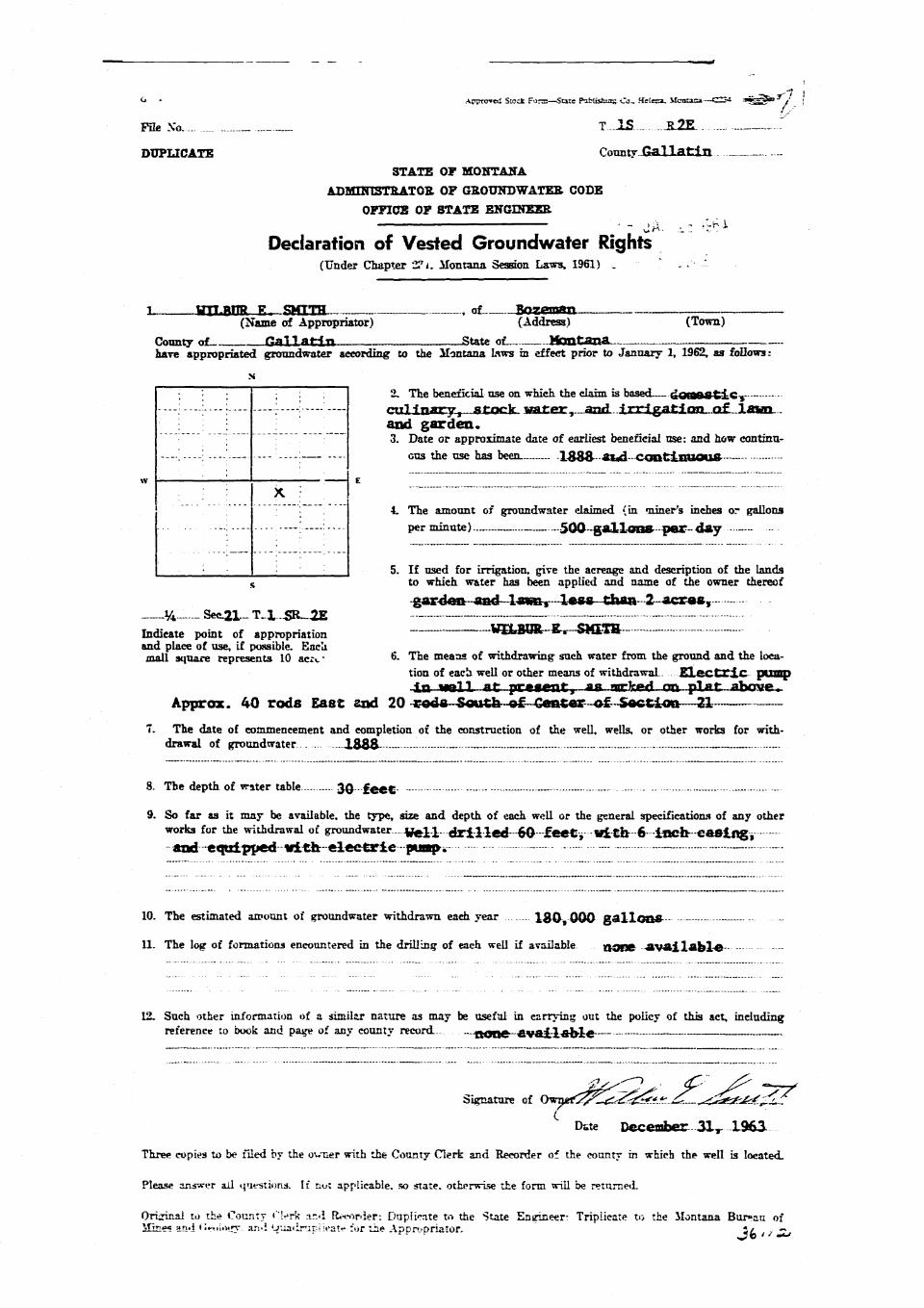
l wrrytTR P. SMTTH , of Bnzpm/m(Name of Appropriator) (Address) (Town)
County of G^I I f l f in State of Montanahave appropriated groundwater according to the Montana Liws in effect prior to January 1, 1962, as follows:
N
[ : i : ; ; 2. The beneficial use on which the claim is based £ o r a a & t i c v —-.—'• :-—: ; : — ^ H n a r y , «£nek watreir, and -I irrigation o£ lawn
': ; i _ and g a r d e n ., ^ ^ ^ approximate date of earliest beneficial use: and how continu-
---'.—; ----' — — GUS the use has been lS8&aud continuous— -
, v • : : 1 E
. : : X. i "~ ~"~ ~* '• ; 4. The amount of groundwater claimed (in "niner's inches or gallons
••-•:--- --; perminute) 500 g a l l o n * per day
: I : I 5. If used for irrigation, give the acreage and description of the landss to which w&ter has been applied and name of the owner thereof
garden and lawnt 1«68 than 2 acrag,
Indicate point of appropriation —WB.I0R-S-.--SiftTR -and place of use, if possible. Eaclimall square represents 10 ac;<. * 6. The means of withdrawing such water from the ground and the loca-
tion of each well or other means of withdrawal Electric pumpin well at present, a« narked on plat above^
Approx. 40 rods East and 20 -goda-South of Center—of Section—217. The date of commencement and completion of the construction of the well, wells, or other works for with-
drawal of groundwater ..... 1 8 & S - —- _ - —
8. The depth of water table 30 f e e t — -----
9. So far as it may be available, the type, size and depth of each well or the general specifications of any otherworks for the withdrawal of Sroundwater...-4^]..X-..dFll-led~6O-^£«etv--1fl^"6---i»efe--«a8li|gy
and-equipped nith-eleetrie pwa|K
10. The estimated amount of groundwater withdrawn each year 1 8 0 000 g a l l o n s - - -
11. The log of formations encountered in the drilling of each well if available nOEJB a v a i l a b l e
12. Such other information of a similar nature as may be useful in carrying out the policy of this act, includingreference to book and page of any county record.- ROUC a v a i l a b l e - —
Signature of 0wn«rC^^^5^*^ .^^^<^a? i^=C-^ - -
Dste December 3 1 T 1963-
Three copies to be filed by the ovcer with the County Clerk and Recorder of the county in which the well is located.
Please answer ail tjuesTioris. If not ap»p!ieabie. so state, otherwise the form will be returned.
Original to the County I'l^rk a.i<i Recorder: Duplicate tn the State Engineer- Triplicate to the Montana Bur»aa of'.fir;us -Anil ti'it-uUwnr. ajvi OUaiiruraeatt* for tin? Aopropriator. j / —
I
i
if •LI
t
/if?
— f^ o'cTocRX__M.
/•CDUMTX Of lK 4 RECORDER
_ ^ y ^ 3 ' C J DEPUTY
GW : Approved Stock Form—State Pubiivbins Co_ Helena. Mosaaa—IS6G. , J ^ * 3
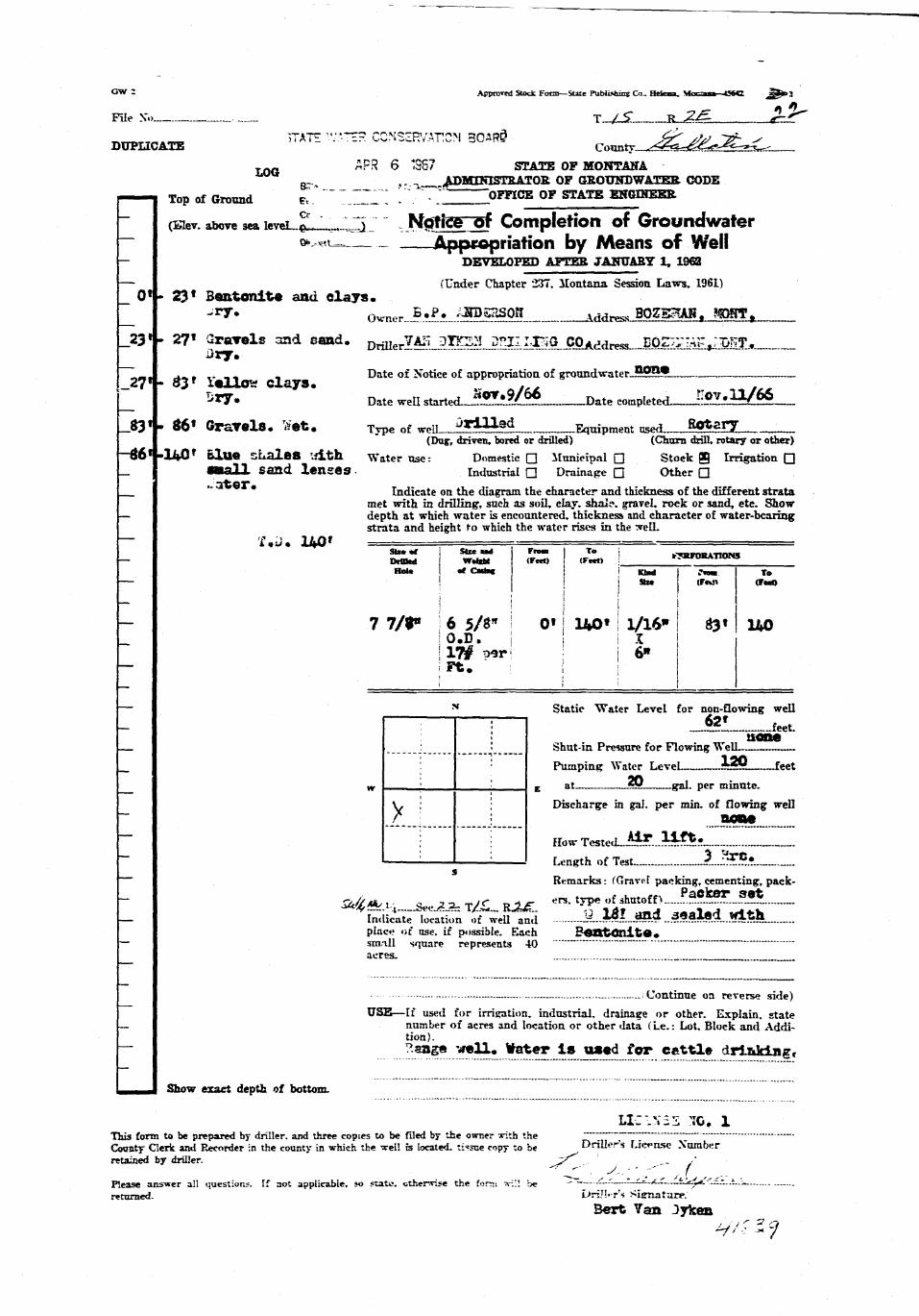
File K.) T_/JT R 2£- £zf^"
DUPLICATE C« nty .^<gta-^^^--^v--
L 0 Q APR 6 1367 STATE OF MONTANAg-., ^ , . a .ADMmiSTRATOB OF GROUNDWATEB CODE
——"I Top of Ground e " T.ZITI • -- OFFICE OF STATE EKOIHEEB.
(^v. above sea leveL^Ll^lIir Notice—gf Completion of Ground water— * . , * * _ _ Appropriation by Means of Well— DEVELOFED AFTER JANUARY 1, 196B
— (Under Chapter 237. Montana Session Laws, 1961)
_ 01 - 23* Sentonit* and clays._ - * * • , W n o r 5 . P . AHPSaSQH W w w BOZSHAS. ?TOITt
_23* - 271 Gravels and sand. D^^^JiTT^^^J:^^Cgj^dT^_BQ^^^Mlj,.Dry.
~ _ . ^ _ . „ __ _ Date of Notice of appropriation, of groundwater_??5*
_27'-33f iellow clays. ,. «/*< , , / * *_ SIT. Date weEstarted^5!!^/°*_.___J)ate completed ?i£?J^£S»-__83». S6« Gravels. Wet. Type of »n» ^«m»<i Equipment ng^ Rotary
(Dap, driven, bored or drilled) (Churn drill, rotary or other)-fl6 f -140 r b lue sLalBB wi th Water ose: Domestic Q Municipal • Stock B Irrigation Q_ M U L I I Sand lens«9 • Industrial • Drainage • Other •
. . . Indicate on the diagram the character and thickness of the different stratamet with in drilling, such as soil, clay, shale, gravel, rock or sand, etc. Show
— depth at which water is encountered, thickness and character of water-bearingstrata and height to which the water rises in the :veLL
— •imiim 140 f
Hot* of CatiM | \ Klod Traa T .> [ Sis* (Ft«Jl (F«O
I I I 1 !— 7 7/f \ 6 5/S" I 0' ! 14O» | 1A6» 3« 140
! 0 . D . i ! I X! 17# t^r i 6"
— ' ; i I
— v Static "Water Level for non-flowing well
I—;—I—j—I _J2L_fc«t: uone
: ! Shat-in Pressure for Flowing Well
_ I • Pumping Water Level i**! feet
w ; I E at ~x gal. per minute.
V> : ; Discharge in gal. per min. of flowing well
X...1 j __•?••; : How Tested...^? .?t^!?.;
~ I 1 1 i Length of Test *_..?£?_?Remarks: (Gravel packing, cementing, pack-
~ 2c/l#v\. , . 2 2 - T / r R i jT e r s- t vPe'»f shutoff>_....P.?.?.^??...??*.— fridicate" lora'tUm ot weU and £...^l..J«d..3ealed .with.
place of use. if possible. Each BeXKtOnlte.— sm-ill square represents 40 ~ ~ ~ ~*
acres.
- — Continue on reverse side)
USE—If used for irrigation, industrial, drainage or other. Explain, state_ number of acres and location or other data (Le.: Lot. Block and Addi-
tion).
— ?anS« wel^« *a*er is «««<i for cattl» drinking*
a ^Hal Show exact depth of bottom.
UCIVSS 70. 1This form to be prepared by driller, and three copies to be filed by the owner irith the \ _ ; ; —County Clerk and Recorder in the county in which the well fa located, ti'sne copy to be Drillers License Xurab«rretained by driller. z/ /
Please answer a!! questions. If not applicable, so state, cthenvise the form -xiV. be " •" '--•-——L^~^-'-—^=--^.''---t-.r..^returned. L/riJ'.-rs Si«rnature.
B«rt Tan Jykea

State of Montana y•bounty of Gallatin f s s"
Filed CCffel/f 3 , 1967
7* / /• v*/ /
-, CcuntYjClerk & Recorder "^>c?
Fee ? / " — revf .

M^^B__SB___SS_SS^5 I^^^^S|&^^S
G\- ApproTel StOvk Fcrca—Sore rutlishiog Co_ Helena. Mean——CZ5J- =*>SKJ">:3 " S •HBE
HHflBFile No — T.I. S _.._2E - flKfifil
•UKDUPLICATE Coonty.JG«__tI_- | ^ ^ B
STATE o? MONTANA Batch. loose, Horse laage ^ ^ BADMINISTBATOS OF GEOTJNDWATER CODE HjH
OFFICE OF STATK EN«HN2£R . . H
Declaration of Vested Groundwater Rights H |(Under Chapter 237. Montana Session Laws, 1961) - ^Hfl
i^JkrxlfPaJP^ Anderaoiu Jx- of4Q5 Heat Clercl_i_, Boze__ fiflR(Name of Appropriator) (Address) (Town) 9 H B
Cormty nf Gal l* t in State of *OO£*m | Hhave appropriated groundwater according to the Montana la—3 in effect prior to January 1, 1962, as follows: B B ^ H
N _ E H I• i • I • ; ! 1 2. The beneficial use on. which the cJaim is based-CD—dOBS—tiC ^ ^ • H
. . : L-: L - ... and stock water; (2) stock jmter O H j
.„_,.„., . . - . ^ Date or approximate date of earliest beneficial use; and how continu- • _ •JLJ... . . . i . _ . - — : .„. 0Qs the u.e has been l * i o r jto_JLMO, OdBjdtaBWW...... WTO i i ;. ..J5W«.JitB«e_Jia#0,... _.. Mi
w . : 1 : : . _._ | H"•- : i. Tne araouct of groondwater claimed (in miner's inches or gallons ^ ^ ^ H
....I... : —.! - — L - : - - per ramute)._.-O)^2S_»lll«n».-.»»..«i»^«*.-^ ^ H; l2X~ 10 pilling yer »lawte ^tgtwwted, fl^H
' : : : 5. If used for irrigation, give the acreage and description of the lands ^^^^Bs to which water has been applied and name of the owner thereoi H^H
l2$JSKr!!b«ja.TJSBMB ._ • •^^^^B
Indicate point of appropriation ~ ' ^ ^ H Hand place of use, if possible. Each , , , , , ^ ^ ^ Hsmall square represents 10 acres. 6- The means of withdrawing such water from the groond and the loca- ^ ^ ^ B
tion of each well or other means of withdrnral P ? * P ? •^•^•1
7. The date of commencement and completion of the construction of the well, wells, or other jjorfo for with- i^^Hdrawal of KTOundwater *t£SLgdLjSSMtjkg^.V*£^ -• ^ H
Cll contixEKjaa u«« »ii»<?e l?60f _ _ „ ^ H
8. The depth of water table 1 0 0 f e e t . ~ _. _ ^ ^ H
9. So far as it may be available, the type, size and depdi of each well or the general specifications of any other | ^ ^ Hworks for the withdrawal of groundwater- .11 /—*39' . .* • •? !L. .™^P __ _— ^ ^ ^ B
_ ._ „ _..C2/...$20L £e«t deep __ _ ^ H
10. The estimated amount of groundwater withdrawn each year f l ) .lOOyOOQ. g> l» .JdttrlMwtTfd^-— -- ^ ^ B B(2) 10,000 w|.. estlaated. ^ H
11. The log of formations encountered La ths drilling of each well if available J i e t *.V*.A**»>1* ^ ^ ^ B
12. Such other information of u similar nature as may be useful in carrying out the policy of this act, including ^ 1 ^ 0reference to book and page of any county 'tcord JSflBM. HB
___. ___ ~zn~~ HH"" - ~ ~ " M i
Signature of Ownerf^«^g.^~—«i_^^^^_gajfeaa_A^ r^^ 9 j _ H
Date Dec_bex 30^ 1963 KBH
Three copies to be filed by the owner with the Coun;y Clerk and Recorder of the county in which the well is located. j ^ ^ H
Please answer all questions. If not applicable, so state, otherwise the form will be returned. fl_H
__BOriginal to the County Clerk and Recorder: Duplicate to the 3tat*t En*r.r.«r: Triplicate to the Montana Bureau of ! _ _ •Mines an<i * J«H)l'>jrv. ar«i Qua<inipiicate for the Appropriator. . iflHl
MM________________________—_______________________________•___••_____—-——_—_ ____L

I
it
Ii
iI
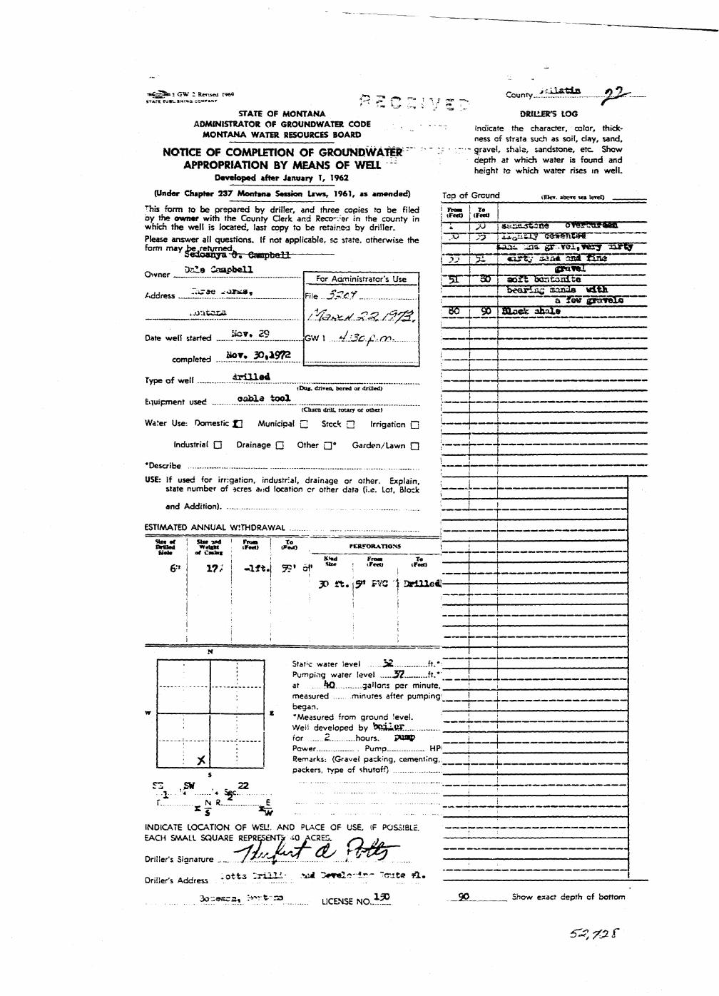
«^.jCw:Rw«atw »»•-.__ County .•f'jj.ffife fkjur.' • = • » •_ -< • ; - , ^ ' . : ^ , • •
STATE O F M O N T A N A "" DRILLER'S LOG
ADMINISTRATOR O F GROUNDWATER CODE , . . , - , ^ ^ e c h ^ t h f c k .
M O N T A N A W A T E R RESOURCES BOARD n e s s o f s t r a t a s u c h a s d a y ^
NOTICE OF COMPLETION OF GROUNDWAtEfc r - -gravel shale, sandstone, etc Show
APPROPRIATION BY MEANS OF WELL - g * - <%* — " j ^Developed after January 1, 1962
(Under Chapter 237 Montana Se-ion Laws, 1961, as amended) Top of Ground (Be». »t»«*» i««o"This form to be prepared by driller, and three copies to be Filed j **«•» ! Toby the owner with the County Clerk and Reco-Jar in the county in 1 >F*€t) j <F"° . ^ . J ^ I ^ - A . —which the well is located, last copy to be retainer by driller. f~I j yj | SJ^aautMCa OTeraogaan Please answer all questions. If not applicable, sc state, otherwise the i ~ T ~ t Xf I xI^,acJ^"'bfe»el».Ca4 'form may .be-retyrned,, ! \ ifcaju. ana gr *aitTC-f '=a«y
Sedoanya 0 . CamyLull p — T b- . '"HEgt j aaa& aSa\fia»- ner Dale Saapbell . , i I *"1pra-»luwner For Administrator's Use )'3T 30 ad'gfc Tboatoaifco
Address F,ie .._?^.«r _ :~~~l~riZ "yTSTgnSSEiif2*2» /:^^^^.Z^^ ;_gO__ug),|aa^3tolO| , m
Date well started ^J^J?? GW 1 ....dj3c.f.:<r>r — —
completed . . . . ^ ' . J ^ ? ? ? | ] \ 1 [
Type of well * * * ^ * * _ I \ \ • • - - •(Dai. diiTtn. bored or drffled) _ _ _ _ _ _ _ _ _ _ -
Equipment used _ .?.^.a..*?* __ \ 1 \(Chum drill, rotary or oilier) I _ _ _ _ _ _______________^_______________»
Water Use-. Domestic __ Municipal G Stock Q Irrigation Q ' !
Industrial • Drainage Q Other • * Garden/Lawn Q :; 1
•Describe _. '—-—i - — — ~ ——————USE: tf used for irrigation, industrial, drainage or other. Explain, ; j 1
state number of acres a<id location or other data (i-e. Lot, Block ~~ ~ ~ —
and Addition) .._. : , . .., j . . ' • _ . , ;
ESTIMATED ANNUAL WITHDRAWAL !
nmitd | w<i«M ir<c<) ! &Zn PERFORATIONS i jMai* of CaUac ' : l , -r 1
: ' KMut From To .
& v?; - a « . | 95« of *• ! lFwt) i «**> L 11 ' 30 i t . \y PVC 1 3rUXe« -3- i ;
i ! i • I ;~ i ji ; ; • \ j [ —• 1 ' : ! i | j
- _ . ^J i I Sta^c water level 3£ —..ft.*- T ~
! Pgmping water level 3 7 ^ > * ' ~ _)-— - -J at |K) gallons per minute, \ i
measured minutes after pumping' 1 [_began. | I
; ; 'Measured from ground level. | _; : Well developed by boiiftE T I ]i.^ . for 2. hours. P*U*1P i_; j Power Pump ..„ HP' j j• ^ ' Remarks: (Gravel packing, cementing,; ' _
packers, type of shutoff) : i !
C"*7 qu po — ~~ " '" " " —• ' •fcJl--'-* '« 5§c- - - - :
r N C _.. E - - • - . srT ** - ."
INDICATE LOCATION OF WEU. AND PLACE OF USE, IF POSSIBLE. • •EACH SMALL SQUARE REPRESENTSr iO ACRES. >--x y • ;
Driller's Signature /.^r^ZZf.. %T^.....i.. J...^!-< ;
n -ii » j j .ot-ts - r i l l i ' rvul r e l o - l r - "crate A* ~Drillers Address .
3O-9SC2, t^ r t S3 LICENSE N O . . 1 ? . ^ • S h o w e S a C t d e p t h ° f b o t t o m
&Z7& f

32-eJ
Sterte of Montana •County of Gafetin » 9 B l
Filed S * ^ ^ p y T f . - r ?
3 t Y'3<J ^.o'doctc^M.
County Ctork A RmomrHTTy
By
Fee $ _ £ _ £ _ _ _ _ _
ff* AstraTtil Sroci F--m:—State P-ialisSinc Co.. Helena. M o n t a n a — C ^ l « ^ w « > 3 :'
Me No T....IS... Jt ?R _.
DUPLICATE C o u n t y - G * l l « f c £ x i ,
STATB OF MONTANA __
ADBUHISTEATOR OF GBOUNDWATER CODE
OFFICE OF STATE ENGINEER _ . ^ : , —
Declaration of Vested Groundwater Rights(Under Chapter 237, Montana Session Laws, 1961)"
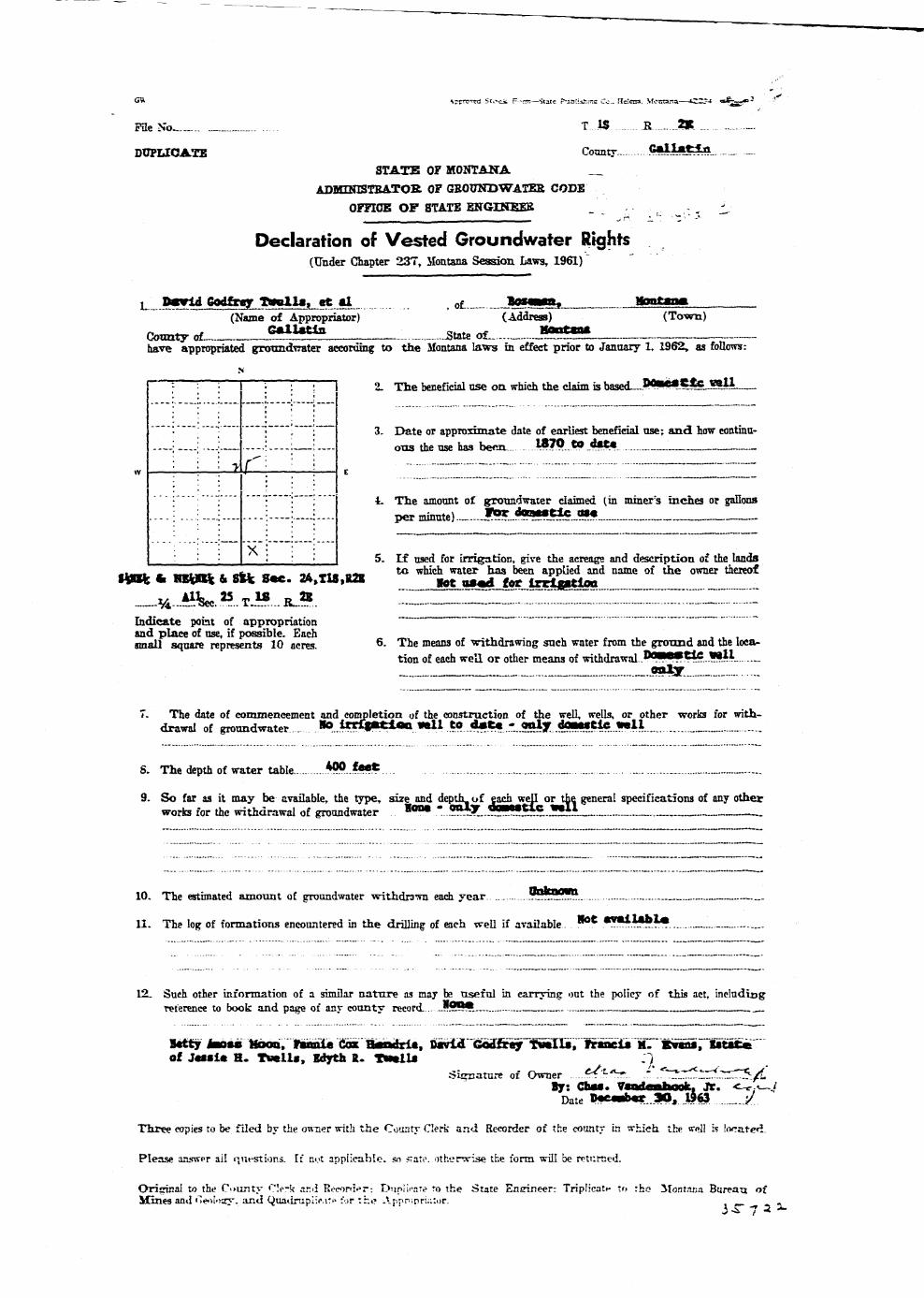
L Daarid Godfrey T w n l l « , e t §1 ol Ttotiggmi, Montana(Name of Appropriator) (Address) (Town)
Comity of ??m^ State oL. _ J55-Lhave appropriated grotmdTrater according to the Montana laws in effect prior to January 1, 1962, as follows:
N
| • ; i • • ! I 2. The beneficial use on which the claim is based—P*l*#-^**L?lii
"• :'""• • ', • 3. Date or approximate date of earliest beneficial use; and how eontinu-—_.: '; -..; ; : ':. ous the use has been. )&7P..**_$•*•
'• ; i r" '• ' ; _
* —i—;—: TW —•—;— E ;;
"" : • •" : ; 4. The amount of groundwater claimed (in miner's inches or gallons; ....:....- ';—: •.... per jninntp) - *?* to—tlc d—
". : """: X ' • '• : '• I ' • : : I 5. I f used for irrigation, give the acreage and description of the lands
S*!fc t HEW ^ 8 ^ . 24.TU.R2K te W ^ S i ! ^ £ S r S S ^ d """I"' T ^^__%-^«.». T J»... BJ».. IZ i i .:::L: :::::.: JZZZLJIZIIndicate pofat of appropriation ~ " ~and place of use, if possible. Each - _ . . , , . , . . , » . ,small square represents 10 acres. 6 - T i e means of withdrawing snch water from the ground and the loca-
tion of each we'd or other means of withdrawal-."••••~*-.l!**-r. __ oaly ._
7. The date of commencement and completion of the construction of the well, wells, or other -works for with-drawal of groundwater . •p_toriCiBBt*«ti ««11 t o d * t « - o n l y dOMJtlc w e l l _
8. The depth of water table *??. .*••*. . . . _ ._
9. So far as it may be available, the type, size and depUL of eachjrejl or the general specifications of any otherworks for the withdrawal of groundwater • * * "..??"?.. ™5*l!£l5..5l*~~.
10. The estimated amount of groundwater withdrawn each year ~~^?^..
11. The log of formations encountered in the drilling of each well if available. *° * * * ~ ~ ? ~ *
12. Such other information of a similar nature as may be useful in carryinc out the policy of this act, includingreference to book and page of any county record .?99* ~.
Ictty Jao«s Mood, tunle Cdi B«ndri*, imviA Godfi«r}r"fiai«Ili,I Tftinc^1irriSvSr*«ttBc«iof J«Mle H. Twell., Edyth I. T««1U . )
Sicnature of Owner ^LAT 1\^^^'.^I^/LBy: Chas. Vsadenfeook, Jr. <~c<-~i
Date B<pc«db«r..apJ 1963 _ _ j / . .
Three eopies to be filed by the o-w-ner with the County Clerk and Recorder of the county in wfaieh the vrnll Is locate«L
Please answer ail questions. If nut applicable, so *tat<\ otherwise the form will be returned.
Orisrinal to the County Clerk and Roconkr-. Dupi'u'aTe o the State Engineer: TripHcatt- to the Montana Bureau ofMines and '"leol'Kry. and Quadrupiicitt' for the Appnonatur. _ .
-— • - C\ . t- ..
—-——~--'^*' ^'"'Jt/nn
— - ^ ; . .Fee S ^'r'"
,J ^ ^ ^
X

' 3 ApproTed Stock Fom—State Pttbibiuns Co_ Helena. Monianar—39089 i < f e > "J if
/ <T i^T" *•'"•'"File Xo T / -•> R <** <- _
DUPLICATE County ^?/?*- £-f?~7I/JV
STATE OF MONTANA [F)F C E5 VE^ 'ADMINISTBATOR OF GEOTJNDWATER CODE uj-wiUidVi, :; .
f | 1 t i i jOFFICE OF STATE ENGINEER U U ^ Q - j c ,^n \~.J
Notice of Completion of Groundwater AppropriiS^E ENGINEERWithout Well
(Under Chapter 237 Montana Session Lavrsr 1961>
Date of jacpropriatien o ^ G r o u n d w a t e r j ! ? i ^ j r ^ l . . 5 ^ — " - " - ~ - f
Contractor (if any) -L^f-fijL/<./sji.Ct.o^-t^f —
Address of Contractor
Date Started Date Completed
N Describe means of obtaining groundwater without a •well "as by1 : i 1 ; ; 1 sub-irrigation and other natural processes". Indude depth to
__j L—i L_j j water when appUcabIe . .vA^-X^^^-C«. . ._ . i /3^ /S/ . .^
': i • i i 1 Q(^^b-?J?.<=~Q - Jj&ljTh^J*±.^y<^L^_j [ j i i i **' ~ ••" " "
w • • • 1 1 : E
_; :___ ; ; j ! Quantity of watsr developed and used with explanation, of method^ V' i ' ' ' '< used to measure or estimate such amount. If use is intermittent
s estimate approximate lengths of periods of vaeJaZ/l.lfi&SI&L.-.fJe
Indicate point of appropriationand place of use . if possible. ^./^j£ _/ ££TJ}_..7j©_. J^^
Signature of Owner fm^a.y.~-.//....r.<:r-iiry.~ KjPjnyf-
This form to l>«? prepared by contractor (if any), otherwise by the owner.
Three copies of this notice are to be filed with the County Clerk and Recorder of the county in which theworks are located.
Please answer a l l questions. If not applicable, so state, otherwise the form will he returned.
Original to the County Clerk and Recorder; duplicate to the StaU Engineer: Triplicate to t h e JlontanaBureau of Mines and Geology and Quadruplicate for the Appropriator.

State of Montana ) ^ ^Cc-^nty of Gallatin \
at i2__L__o'cfockS_M.
- A . COWIU CLtftK £ KCCRDER
Fee s 3.—- 'JdC.
i - ~
^ ,*?pta*Bl SU' JL Font—Sure Publishing Co- Helen. Montana—59089 «^_ a>3 j |
File No T / ^ Jj Ji k?
DTJFLICATE Camt jp) #*-*- #~77AfSTAiTE OP MOHTANA
ADMINISTRATOR OF GROONDWATER CCDE |~G~) S C E 1 V E Fn^jOFFICE OF STATE ENGINEER \\\\ \u\
u U AUG 15 1963 L - /
Declaration of Vested Groundwafer Rights., Tr . ^^ (Under Chapter 237, Montana Session Laws. 1&61) ^ I A I t L IN b 1 N L h R
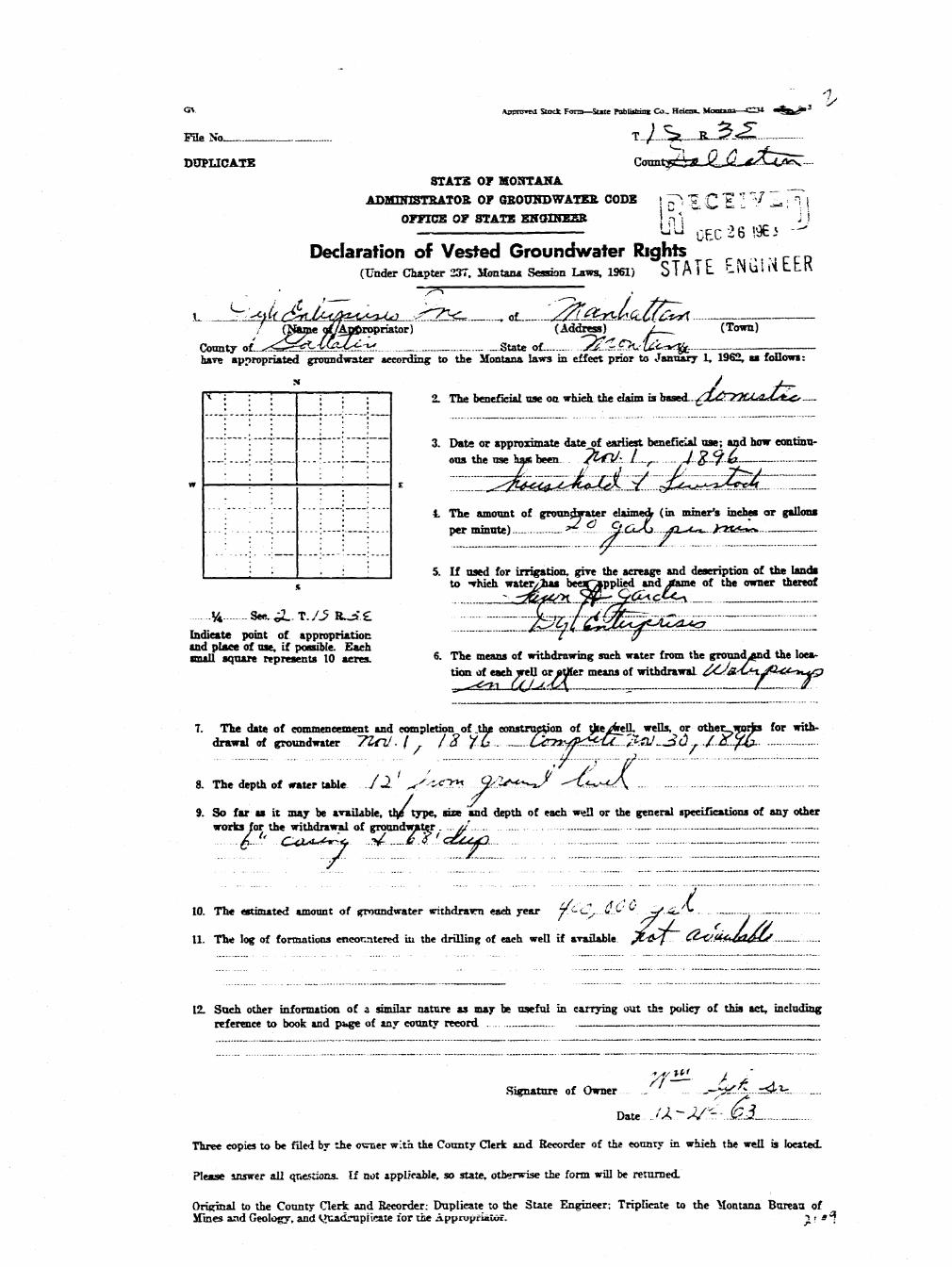
^HL m c? f^gLi/lH ft. / - ou (z Snjfi&rFfr&xrs(Xftme of Appropriates; (Address^ (Town)
County »f *^S+t. C~t+-rjf>/ State «f Afe/V i-ff-fSfihave appropriated groundwater according to the Montana laws in effect prior to January 1, 1S>62. as follows:
.N ^
' : , 2. The beneficial use on which the claim is based_4^J^*l^*» ' . . f.7~..
; '. • ; : 3. Date or approximate date ofepriiest beneficial use; and how coa-i j ! ; ! ' tumons the use has been^/LSJL^.-JT^J^JXEZS.; ! ; 1 ; I ; €cL**-'?ll.M-U..G>ULJZ.-L.p!.
; • : I : 4. The amount of groundwater claimed (in miner's inches or gallons1 ; , ; ; >-— per minute)
' ; ' 1 5. If used for irrigution, give the acreage and description of tne landss to^which water has been applied and name of the owner thereof
<ifaj£j}Jd£HL-/^£.t3LtJ§J9Lrf Q.&CS£irXeLR*<>?$ T/5 U.i^*'Indicate point of appropriationand place of use. if possible. . _ , - . , , . . . , , ,Each small square represents 10 •*- The means of wrthdrawing such water frcm the ground and theacres. location of each well or other means of withdi-awaL.fe^«JC5C.ZI^*/C
i^i:_.T^/^L^_ej^Lfi£h7. The date of commencement and completion of the construction of the wtll, wells, or other works for with-
drawal of groundwater..t(C.*w£y_<.rs/.»JU*!*..A/
S. The depth of water table._*t.V/ „ „ _._
9. So far as it may be available the type, size ana depth of each well or the general specifications of any otherworks for the withdrawal of -roundwater_.o?b &.tJte£LJbJ££j£--j!>J..£i£r- QJ*£&QL)IUJ6G-.^ f c f S f T * . _
10. The estimated amount of crounilwater withdrawn each yea/^rftoOj-*-**-** ^-4$-t*
11. The log of formations encountered in the drillimr of «aeh well if available^/.<Nf.>5 iSJGjJL-.£LQ.L*££Z~
12. Such other information of a similar nature as may be useful in carrying out th2 policy of this act, iiusladingreference to book and p.' ire of any '-ounty record „ _
Signature of fhm»r>ly. sf . U^f^Afli/C^
Three copies to be filed by the owner with the County Clck and Recorder of the county in which the well islocated.
Please answer all questions. If not applicable. *o state, otherwise the form will be returned.
Original to the County Clerk and Recorder; duplicate to the State Engineer; Triplicate to the Montana Bureauof Mines and Geology, and Quadruplicate for the Appropriator.
r
. : - : - T / 3f ^ailatin" f
G w 2 Approraf Stock Form—State Publishing C o , Helena. Momma—C3i. >j^fr» a
File No * T__/>5_R_JLi£___^2.
DUPLICATE C<mitF-^k^Jd^^=L
M 0 STATE OF MONTANAADMINISTRATOR OF GBOUNDWATER CODE
• Top of Ground OFFICE OF STATE ENGINEER
(Eier. above sea level ) Notice of Completion of Groundwater~ Appropriation by Means of Well~ DEVELOPED AFTER JANUARY 1, 1962
(Under Chapter 237T Montana Session. Laws. 1961)
- 0 « - 1* S o i l s and d - y s . * C H T - F I ; i H ^ G A l M S 3EPT.GRAICLIFF FISHIHG SITB._ rwJffLL HO. 1 LOOP A SO. XMr^ HSLSHA aOHTAHA
1* -12* Saad and grave l s** e t a t 6» nrfnJTAH DTKEM 3RILLIKG C O . ^ r ^ BOZ15KAK, SPETAgA
1 2 ' • —43* F i n * heaVii i^ Date of Notice of appropriation of grouro'watiT ft*?***saada* Wet* 6/15/60 A/IJ*/AQ
Date well started.—ZL.tz£-?l Date «»nmpl«>t«T O/J-Q/Oy4 3 ' -50* o i l t y daybound n-»T»-* ^ wi ^ -.
— sands, tfet. TyPe °* w t > n ^ ^ • * ^ Equipment t^ediS^JA-.tL<QQJLaA(jyng. Driven, bored or drilled) (Chora drill, rotary or other)
~5()t, »71t Soft 8fiIldStOae• Water use: Domestic Q Municipal Q Stock n Irrigation •— ¥at-»Y» Industrial Q Drainage Q Other H
" t t U t u • Fisniiut accdas s i t * .— Indicate on the diagram the character ana thickness ox the different strata7 1 ' 1 —72* G r i t t y d a y s * met with drilling, such as soil, clay, shale, gravel, rock or sand, etc. Show
— depth at which water is encountered, thickness and character of water-bearingstrata and height to which the water rises in the welL
Hate ofCutac U H I fto^ T o
6 5/«"0.b. te "-" ^6" 19#p«rffc. O«i53»7"| i aon«
— jKew t e a - j i
- \y I . D . 2«iIgeaTy j 0* I 72' 1/16* $2' 72'
N Static Water Level for non-flov.-ing wellI 1 : 1 3 * 6 * ,
— : „ _ £ _ ? leet.
— j Shut-in Pressure for Flowing Well55??_—.
_ *< ' Pumping Water LeveL_Jk5l6*l____feet
w ; I c at ^T gal* per minute.
: : Discharge in gal. per min. of flowing well
. - . . . —IMiRsS .
~ ; % How Tested. B«iiSff
~ I 1 : Length of Test. 2 H^!!f
<-, -/f • u J^ j2£TKemarks: (Gravel packing, cementing,pack-
^ _ _ S e c ^ . T ^ K ^ e r S - ^ °f ^off)_TOE_12!— Indicate location of well and «** " a ^ " g <« gr^fl^tii 1w
place of use, if possible. Each w*th canon t,small square represents 40acres. _
_. i Continue on reverse side)
USE—If i-seil for irrigation, industrial. <lraina^ or Dtfaer. Explain, state— number of acr^s aR«i Icoaiion -.ir '>th»r data (LP.: Lot. Block and Addi-
tion;. ^ ^ / /"~ [fas-.' f 'y-j^jjs i "sfyXuK <^c*-ppJ^
_ J Show exact depth of bottom.
LICENSE MO. 1This form to be prepared by .Mller, and three copies to be filed by the owner with ihe 73ri ~- "County Clerk »nd Recorder in the comity in whkli the weD is located, tissue copy to be DnUer'f jcense Numberretained by driller. v- • -, . • /
~' " ' ' —' -*-"— / ; _. SPlease answer all qnestices. If not applicable, so state, otherwise the form will be ^ ~ ~ O ^ > J*-££_£r.<££:—^_^-t.retarned. Driller's Signature
Bert Yaa Dykai _ , 7 £
•23 ?y
• • * * *
I *. 'Star? cf Wontana iCo - cf Ga!!atin * SS*
Fii '"Xa-tJ /9 . \*&f
I O e p u t y ^
Iti

GW 2 ApFro»ed Stock Fot=—State r&biisSnas Co- Helena. Montana—<232_ j t B s i t e -
File No T__Z=L_JL^£I__Ji2— </ -r' '
DUPLICATE County___=nL.L,c.vX.4c>.v
w a STATE OP MONTANAADMINISTRATOR OF GROTJNDWATBR CODE
——I Top of Qrmmd OFFICE OF STATE ENQlflKKR
(Eter. above sea level ) Notice of Completion of Groundwater~~ Appropriat ion b y M e a n s of Well
DEVELOPED AFTER JANUARY 1, 1962— 0' - l f Soils and days* (Under Chapter 237, Montana Session La€fcl961)
m&?. FISH AND GAMS 0OPT. GRATCLIF? ^ M H G 3IT5.1». - 12« Sands and g r a v e l s . r&8&> HO. 2,L00P B SOUTH ^ m ^ HELSHA flDKYABA
— Water at 7 f «TVffl VAM DUES DRILLING 0 0 ^ , ^ , B0ZK4AK. . ONTAHA
12*. - 2 5 8 Heaving f i n es a n d s * Date of Notice of appropriation of gronndwater "OMB
3 5 ' - - 56» Sands with pat» ™n ^ . . i 6/23/69 Date completed 6/27/69grarels lenses.
— Type of well__J3Slil!id Equipment ns d Cable t o o l s .56*« — 6 6 1 F i n e h e a v i n g (Dug, Driven, bored or drilled) (Churn drill, rotary or other)
S a n d s * "Water use: Domestic • Municipal Q Stock Q Irrigation D— Industrial Q Drainage n Other Qcat *7f\t ^.nwutr, »»>i «••* «kA. P i s n i n K A c c e s s K K A .OOf- - /U* aaXLOS antt l i n e Indicate on the djagranTthe cEaraSer'andifiicfcness of the different strata
gravels* met with in drilling, such as soil, clay, shale, gravel, rock or sand, etc Show— b a r t e r . depth at which water is encountered, thickness and character o£ water-bearing
strata and height to which the water rises in the well.
~ DriDnt Wd«h» CFMO (T*t» rMumKATIOfCIBate atCutat Kind From To
~~ T . D . 7 0 f Sh" Vma o r"°
6» 6 5/Sn O« I 70^ none~ ! O.D. ! T
|19# per_ 1ft. Sev
[Tested— 1
" Static Water Level for non-flowing well
— ; 7*6* feet.
— j Shut-in Pressure for Flowing WelLJUffi*....
_ '. , Pumping Water Level y...~. feet
w : ! E at 15___.gal. per minute.
: Discharge in gaL per min. of flowing welll__ : IB CIW#
~ ^ HowTested^ JBatler;
~ I '• 1 Length of Test ?_J[??.*
'I-I /S </c~ Remarks-. (Gravel packing, cementing, pack-
^ * v L< «s JE3 v^Z x> *&/m'type o f snatoff)t0P_JL21__OC— Indicate location of well and Cfl«llfcJLft_gX3fflt«fl^JUL..wL.t;il.
place of use, if possible. Each cejgenfcjt~ small square represents 40 ' '"'
acres. ._
l/8"L_6r.aS»ia..r.0r^8and. C<ffltJBJ*. tContinue on reverse side)
USE—If used for irris^ation. industrial, drainage or other. Explain, state— number «r aer s and location or otht'r data (i.e.: Lot, Block and Addi-_ t i o n > ' T\ I 4 rt
K"'(i^- \^ ^y^^ A UhixXJU \r~~fyfJ*i
M J Show exact depth of bottom.
LICEK5S tTO. 1This form to be prepared by driller, and Ones copies to be filed by the owner with the n-ni _> r • "^ uCounty aerk and Recorder in the comity ia which the wett is located, tissue copy to be J i t t e r ' s License Numberretained by driller. ^/S / . T ^^- , yPlease answer «n questions. If not applicable, so state, otherwise the form will be-' --m£-ZZJ, , -«-..<.fc^tejfc^X-r ^L-returned. Driller's Signature /
Bert Van Dyken
II
State of Montana )CcL-nty :f Gaflatin f s s*
I ' —I
II
tI

l i v Approved Stock Fonr.—State Publishing Co.. Helena. Montana—?S6»T a i j ^ >3 1 ^
FUe No._ _ _ T-ZjSL IL^-^"
DUPLICATE Q,oTnXj-J^^4d^-.^tT'?<' .STATE OF MONTANA ^ _^
ADMINISTRATOR OP GROUNDWATER CODE j [T; E C E il V" ii* I Pi !OFFICE OF STATE ENGINEER (j\j 0 „ ,,T, > :JjJ
Declaration of Vested Groundwater Rights j r p^p,^rpp(Under Chapter 237, Montana Session Laws, 1961) "" " '
, cf. /L . /C//& Q/^ /~ nf/P/f > ~7AZST&S £^>^/ZS(Name of Appropriator) (Address)- (Town)
County nf <^~'y ^ ^- ^ r " > " ^ State of /^jjfe.**?^'*) <V^Thave appropriated groundwater according to the Montana laws in affect prior to January 1, 1962. as follows;
: : ; • : ; 2. The beneficial use on which the claim is based-^g.£?*. ?.-£££*.,
; ; ; ; ; ; 3. Date or approximate date of earliest beneficial use; and how con-:. i ! : ! ! tinuous the use has heen.ty^rKCC ^•f9-^O, 4tS/? ? ._; • • o n I ; j Me. me s •mr/9.0.,
w ^ L -— i j . - }—- j ^ x
; ; ! : ; ; 4. The amount of groundwater claimed (in miner's inches or gallons: i 1 i j j per minute) ^<L<2~JS1-*?....'fa
—!—I—1 1—I—'&^*»e-LL~ ~' ' '' ' I 5. If ussd for irrigation, give the acreage and description of the lands
s to which water has been applied and name of the owner thereofJ^^.^.!^..^l..jC^^^i^.^~~^T^SJaJi.c^fl
_.»?z.^4<<?.*j«/oec_5->- i.J-if- li-n^fc
Indicate point of appropriation ~and place of use. if possible. „ m. . L J - L * ._ ^ , LEach small square represents 10 6- The means ot withdrawing such water from the ground and theacres. location of each well or other means of withdrawal ,
JEjL*.SJ^JJ*.jZi*.tt~fi.
JZ Z__7. The date of commencement and completion of the construction of the well, wells, or other works for with-
drawal of groundwater S...fS?/.^m.—i^.!^.«^^...^r^^^.^5<;^^rtriCi^...^ „_.^.^^^^At^^uar^t^urrfiL^t^dJt^ £f 4. ^f—— „„
8. The depth of water table—?.f- — — _ _
9. So far as it may be available, the type, size and depth of each well or »he general specifications of any otherworks for the withdrawal of groundwater- ~ — — -.-—___,. _-,—^^:<*b^t^JL£^^Jk.QjL.-Qj&e.jO^^ ?/^X£<jCjL..*ZaZ?L.<-
10. The estimated amount o* groundwater withdrawn each year_ . s?« .*.«»..«». sfcx£*£..£.«!riJL__
11. The log of formations encountered in the drilling of each well if available _ _
12. Such other information of a similar nature as may be useful in carrying cat the policy of this act, includingreference to book and page of any county record . _- :
_ . _. _ . ..____ . . ,.'......_. i_li_ ... >..i_ .'_ .:..:.-. _...;.. _.1.. ._C.:.._...
Sisrnature of Qjrr(SG{~T*trZS--. /Q&??L*?'*!l^Z.- I1Z jr.
Three copies to be filed by the owner with the County Clerk and Recorder of the county in which the well islocated.
Please answer all questions. If not applicable, so state, otherwise the form will be returned.
Original to the County Clerk and Recorder: duplicate to the State Ensmeer: Triplicate to the Montana Bureauof Mines and Geolojry. and Quadruplicate for the Appropriator.

• t
rS t a t e ° ' Montana /
County of GaHatm f «•
^~~pZ~——q;5toc|O2I_M.
By - N ( g 2 / ^ " K * fiacWER
Fee 5 L _ > ^ 2 L £ ^ T ^ 0Q>UTY

G V A«M-o-v«t Stock Fotra—Stile Pablisiin? Co- Helena. Montana—JS6S7 a^_ - 3 /
File No T R_ :r-
DUPLICATE County _.. L _ ' . : . . / ' .
STATE OP BtONTAHA N
ADaHNISTRATOR OP GEROUKDWATER CODE 1 ^ "E C E1 */ \ \UOFFICE OP STATE EKGIRBER i f f > - , , . - - -Jl)
Declaration of Vested Groundwater Rights - f ^ i y e c o(Under Chapter 237T Montana Session Laws. 1961) 0 i K I C
1 \/^/^/<^O^<L Ofj^21J!^^^^k^x_(Name of Appropriator) (AddressW' _ / >• (Town)
County <JLJUJ5bLL/lTZ*fL JState o f _ ™ ^ ^ ^ . ^ ^ . ^have appropriated groundwater according to the ilontana laws i n effect prior to January 1, 1962. as follows:
N
' • ; ; ; ; 2. The bgnefleial ase on which the claim is based .— ; ;—; : ; I— J^^^/^J^L^^^rK^ __
• ; = ; ~~\ • 3. Date or approximate d a t e of earliest beneficial use; and how con-' ; ; ; ; ', tinnous t i ie use has been
; • o *, • • I &a?jOs&.JL. L5M-J0.w — ; ; . AyA , rgr *
'• > i [ A > y . 4. The amount of groundwater claimed (in miner 's inches or gallons—j {—! i—t-i— per minute)_j*L6!L£_*J£
1 '< ' '< ' I 5. If used for irrigation, give the acreage and description of t h e landss to which, water has been applied and name of the owner thereof
"£jA*?^J- T*£ R>£. zzi;::i:zizii:zzzizzziiizzr::zIndicate point of appropriation ~~ ~and place of use, if possible. - - . . - , . , - . •, » ,Each small square represents 10 *>• T h e means of withdrawing such water from, the ground a n d theacres. location of each well or othe^means of prithdrawal
. . „ „ _ y . . „
7. The date of commencement and completion of the construction of the well, wells, or other works f o r •with-drawal of groundwater—„. .... „ —. — _ . —_
8. The depth of water table—o2j?_.?! —
9. So far as it may be available, the type, size and depth of each we'l or the general specifications of a n y otherworks for the withdrawal of groondwater.. — — ~ .
10. The estimated amount of groundwater withdra-wn each year——J2.G.P,—•..©_• _
11. The log of formations encountered in the drilling of each well if available— „ _ _
12. Such oth-rr Information of a similar nature as may be useful in. carrying OUT the policy of this act, includingreference to book and page of any county recorxi : 4- —
_ ^ ^_ _ ' r ^ „_., .^.jf . _
Signaturejjf-WiG??^£-^><^^
Three eopies to be filed by the owner with the County ClerTfand Recorder of the county in which t h e well islocated.
Please answer all questions. If not applicable, so state, otherwise the form will be returned.
Original w> the County Clerk and Recorder: duplicate to the State Engineer; Triplicate to the Montana Bureauof Mines and Geologv. and Quadruplicate for the Appropriator. -•> t
y

State of Montana )County of Gallatin \
FilfM Qc^-^fc- 3- i g 6 3
at ,!_ o'clccfcd—-M.W M i - V til/ U.»<r-w C >
COUNTY C U R K & RECOHOER
' . Ry ^DEPUTY

<*" Approved Stogie. Fonn—Slate Publisiiin- Co.. Helena. Montana—39OS9 « __ * J '-
Pfle No T.../v> K__s?ii=-I
DUPLICATE Cawitr£&^<~J3^Z~£*£--STArE OP MONTAITA ^ ^ _ „ ^ _ __
ADMTNISTBATOR OP GEOTUTDWATEB. CODE 0 j ;£ (L £ . i V JL, pn in "\ 111
OFFICE OF STATE ENGINEER ULl -...,-.,- 4 r « « JJ
Declaration of Vested Groundwater Ri^Hfrr FMCIJUPPBI/) jr (Under Chapter 237, Montana Session Laws. 1961) W U * ' U
dLA*"* AjLojATi ^BhJ-JQsj^^sj^,(Nj*me o£ Appropriator I (Address) (Town.)
County of y ja-jLA^JfrT/ **£ State of, Aj-Qj^ lZ0r/*S/4±have appropriated groundwater according to the llontana laws in effect prior to January 1, 1962. as follows:
j • i~)? : i ! 1 2. The beneficial use on which the claim is based-^dZ^2SS^2jG^^
i—H, ;—i—[— kJ/kTJsl%'; j ; ! ! ! 3. Date or approximate date of earliest beneficial use; and how con-•—•! i ; i ! tiniious the nse h.as been,/^^. 4^&-
w —\—\—; •—i—•— E *~ ~ ' z~mz
I I ; \ i ; 4. The amount ofgroundwateii claimed, (in mineote inches or gallonsj 1 j ; ! 1 p e r minute) J$.Ij£L~!£icJLrf<i» m.*. .••ur>« ,<%„ ^_
1 i ' ! '< '• I 5. If used for irrigation, give the acreage and description, of the landss to \ hich water has been applied and name of the owner thereof
i^iM^fJti ?4£ zi* : — ———-Indicate point of appropriationand place of use, if possible. . . , , . , , , , , t .Each smaU square represents 10 b- ^^e means of withdrawing such, water from the ground and theacres. location of each, -well or other means of withdrawal 4J£fi3&-
7. The date of commencement and completion of the construction of the well, wells, or other works for with-drawal of grotmdwaterj6£sy-Ar.<V-Ctet<£«^ ~ __
S. The depth of water \sSAt^d./S/.f.<y^<OcS-fUs/~
9- So far as it may be available, the type, size an^depth of each well or the general sgpeifications of any otherworks for the withdrawal of groundwater_.^ f-zL^^T^AjL^.^^^Z^^Jj^fi^.G
10. The estimated amount of grounilwater withdrawn each yeaJL^&.r-a?-.4?..C2. __ _
11- The log of formations encountered in the drilling of each well if axaSl&b\sJ^.A/-/<^-^O-CM-A/- •—
12. Such other information of a similar nature as may be useful in carrying out the policy of this act, includingreference to book and page of any county reeord&^fc/^^y Q/JJjs-C
Signature of "^T^^A; {_~*f*fyfjft'^ -—
D a t e ^ ^ > < ^ ^ ^
Three copies to be filed by the owner with the County Clerk and Recorder of the county in which the well islocated.
Please answer all questions. If not applicable, so state, other-ivise the form will be returned.
Original to the County Clerk and Recorder; duplicate to the State Engineer; Triplicate to the ilontana Bureauof Mines and Geology, and Quadruplicate for the Appropriator.

•"•4*7State of Montana \ ^
* County of Galfatin \
F;M AngOSt? 14 1963
,r 3 ;12 o'dock-E^-M.
/O COUfHY CLERK * RECORDER
Fppg.oopa»
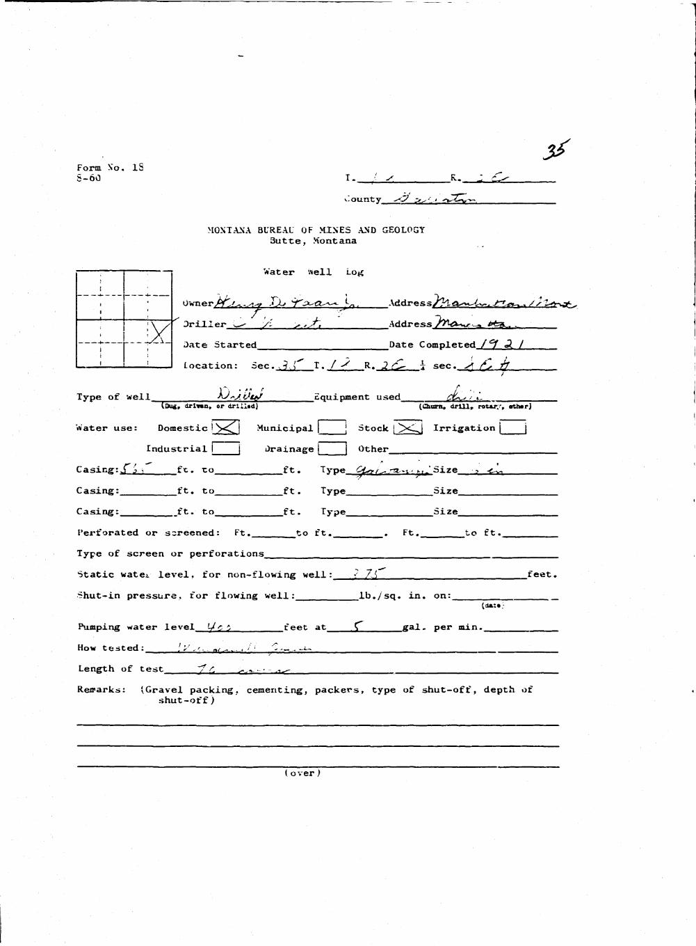
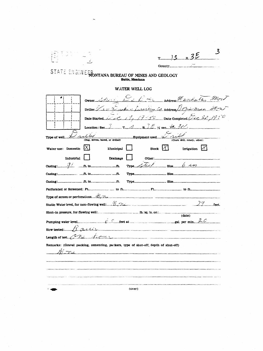
3*Form So. IS5-60 I. Is R . 2 dl^
i . o u n t v *><? >^'.' •r*-^£—u,'~>~,
MONTANA BUREAU OF MIXES AND GEOLOGY3 u t t e , Montana
; ' : r Water well LOJC
i •
i • Owier/V^^../!^ TX* ':f3^€L'~^ *-„ . Address/?! a^^~, JTtet^.* / / t » j t ..
| TV/ d r i l l e r w- ty: ^ ,j[\ Address />^x^r -^ *fe3v_ .
•*. ~cA- 3 a t e Started Date Completed f °J «3. /
! 1 i I Location: Sec.,j,{^ I . f -S R. 2 (C- i sec. £, if
Type of well sQ^jiJte/ Equipment used £%*w ' i.I Dug, drl»«n, or drllitd} (Chant, drill,, rotar;-', «th«rj
|
Water use: Domestic j ><^ Municipal j 5tock | Xl^ Irrigation j j
Industrial I | Drainage | Other
Casing:S j. > ft. to ft. Type A»/^^n-- n r Size ? *c~*~,
Casing: ft. to ft. Type Size
Casing: ft. to ft. Type Size
Perforated or screened: Ft. _to ft., . Ft. to ft.
Type of screen or perforations
Static water level, for non-flowing well: •? 7A feet.
Shut-in pressure, for flowing well: lb./sq. in. on:{dmxm:
Pumping water level '-/c 5 feet at £_ g a l . p e r m i n .
How t e s t e d : [*',',.-. ^/.-..,. • / ' '"- - ^
Length of test ~7 f. > .-.. - • - .^
Reirarks: (Gravel packing, cementing, packers, type of shut-off, depth ofshut-off)
(over)
- T - I -I ,-
I I Hi
? •> ' -14$ W. . . ' , «,. : j ! ; 1 !
! ' i ' r\['
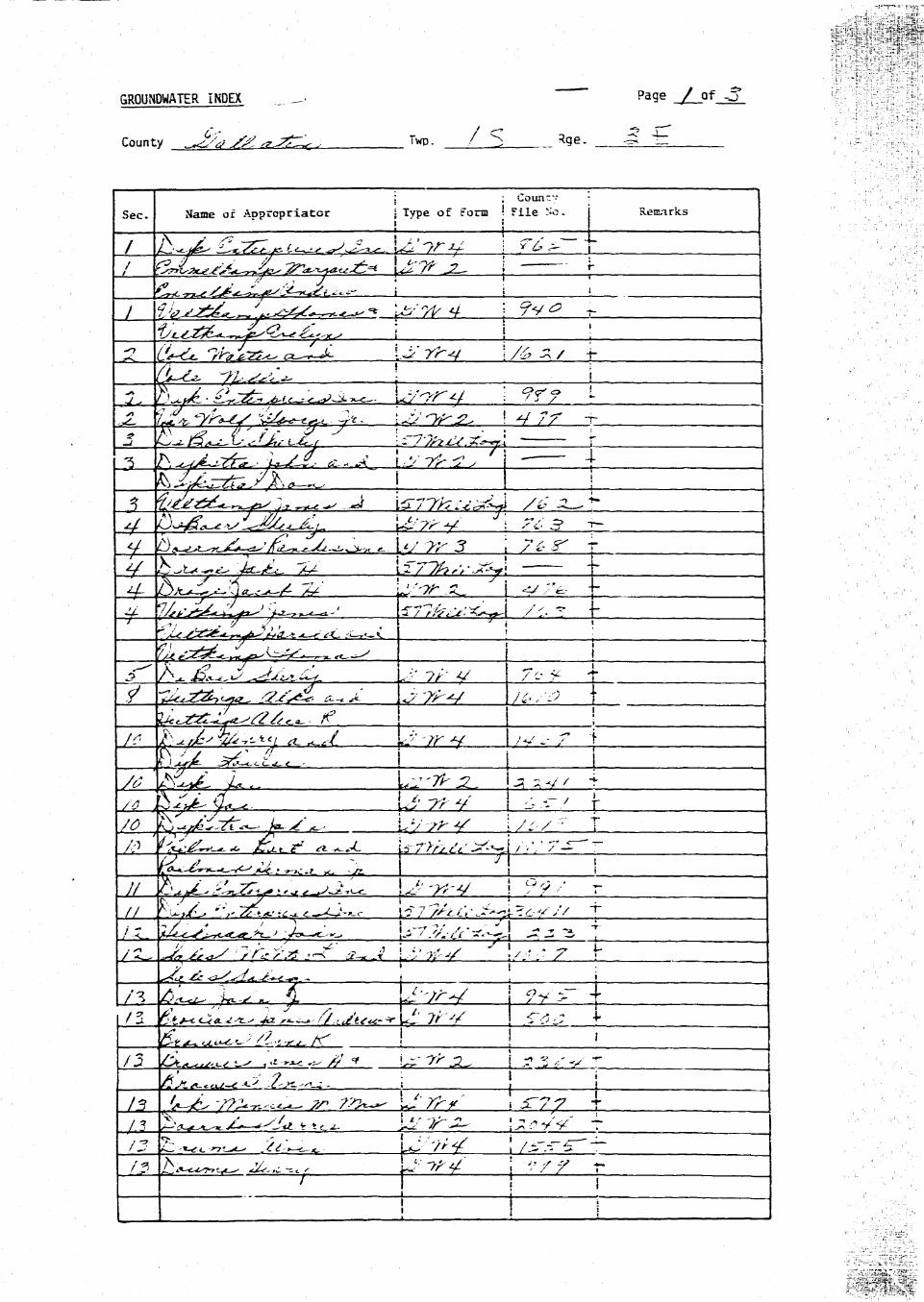
GROUNDWATER INDEX ._.._• ' Page / of -3 r -
County . :V- ^^TZ^ , Twp. _ J / _ S _ _ R? e- ^ —
: : Counrv
Sec. Name of Appropriator • Type of Form •- File No. Remarks
..X /ffii - > ^ ^ iti***.^ ^t. i - o^ ^ j v / r -r • . . •••../••.s? 7^ ^ / / " y • —7--"' / , v ; . •-
I'M. £^'&^^SGS^-:=-^-+—*~~*- ft—S I
l±<j&LZ^a/t^ rf ^ | ;
//T |5J^L-<Z1^- Li' 7-; V 1 ^.-r/ r
// p^J^JSy.*^,.^^. .J--rt-4 \?9'' r
y ' . . j r i • , . • . - '
A' •• ? '• I •
/.3 ^^^/^^.v.tcj . isit^ :; yV T/^ h^..^^ 5*.:^*.. L:-'-/^ ! /JT.-^-~-A3 ^ . ^ > ^ <&-,c~-,f p-'-W \ '?/? r
7 I j
H i i i \.ISA.' «
vT.rarey ^ i v

: ; C o u n t y : •;,. \.':'u:' ' ^ ^ ^ ^ B
Sec. Name of Apprcpriator \ Type of Form ' File Mo. Remarks ' ;^^^B
~ JS.JL- cl^<^ u> 7iw \ /?j 7 r ' ••:.; % ^ H
;-, LS4^- CL^^ZZZ A' [''-/,' V j.•'SS 7 f H
^LJk'/l/cL--- i ' I S -•. ^ R/3 £sL4~^M*^ \jJ7h3U \Jt7 7 i- Wk
i*> ftLJ*Jt* y~~ //-^ U"?r , / / ^ ^ t B
/^ ' ^ ,<^^,u^ ^ Ly f/ ; < -^ j , ^B
/c Ax^f\ft'. * >—- t-fi -x . cL—f.tA..^ j a^^B
sfrt/jL**.'-'-}*-^^ I ! • Hi •;? t ~ y - • / / «• • ->•>- ^ • ' > • -" ! ^ ^ ^ ^ H
/^ ^I^Ec'cJ-€^^£Ei^ £ \^-y;v i / / ?.? - B |
; 'a. .^.- / C j a > £ - < • : - s s t <?*'c^- j j j • ' ^ ^ B
— J -—- —— J I __ j . , ^^^^_
A/ ^;^" i /^^^J > , -A < ci f~7 7 />,y^. T Hi.^u^TC^f^1^ VS" ! : ' ^^H
/y- '^z^:e£6sj! ' Ur •?;-</' I rc^ 4- fli/V ^ u ^ ^ ^ - ^ u ^ ^ - ? Uu "fi< 2- ! (<V/ r flH
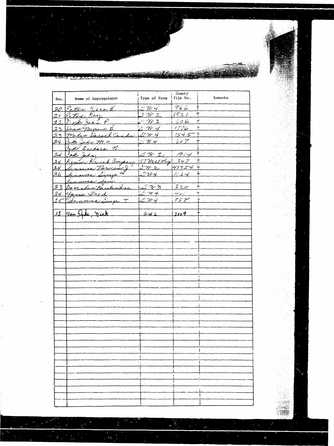
• ; County I :.i/'"" : ^ ^ ^ ^ BSec Name of Aoprcpriator J Type of Forn ' File Mo. Remarks t:; ^^^H
1 : 1 1 .. /'•• • WM
^/ ,^7~o k*^. p^-— \^^/ * ^ 1%n\h^J>^*J^ f Ltr 7r 5- \ Go ^ I ^ H
O^jy £,,J^^ -/?- 1 ; I "'• • • *
3y k',^,Z.,, fa-^J, (Uy<^.. ;-r77/^/j=^r! - ^ 7 f ' / ^ H
y j j 1 •
^^S ...I
**" Appr3%e»i St~cx rcrrr.—Scare ?ur^n.in: Co- Helena. Mttxta^a—£1921 e*_ » 3 j
FSe No. T / r'jR- -3"' E- .
DUPLICATE County W Z.?'i* ~^'I
STATS OF MONTANA
ADMON1STEATOR OF GBOTJNDWATER CODE i—s ™, - , - , „ _ _ .—^
OFFICE OF STATE ENCTJESB j?< ** ^ ' I R |
Declaration ot Vested GrouRdwater RigWtlEC U 1963
(Under Chapter 237, Montana Session Laws, 1361) 5 T AT t E.IHla I N E E R
1 J^uA .£.df7e^^/J-AS , '7 C - , off *fa..9.£tilE*.fi..JjName of Appropriator) (Address) _ - (Town)
County ot Jf>SL.ILzTjA State of. MjLM.i^JL.9^... - -have appropriated groundwater according to the Montana laws in effect prior to January 1, 1962. as follows:
• i • • • ; 2. The beneficial use on which, the claim, is based... ~/y.O~).^^.L/.Sr.
~": . : ; ; 3, Date or approximate date of earliest beneficial u$e; and how contmu-—-': — J -—; • —.: ; -— oos the use has been J^Oft ~ L>J..Q~T'.4..U..QJ&5
vi — . : . : E
; • . ' 4. The amount of groundwater claimed (in miner'a inches or gallons.... -..:— -: ;....:„..;.... per minute) ..._j2 0 ?*&/.... .1/^C MZ/X.-.1
: I • ' 5. If used for irrigation, give the acreage and description of the landss to which water has been applied and name of the owner thereof
crmC
........%j4/see~f_T.. ../5IL.<?£ z~zzzzzzzr.izzzzzz.zzizzi~:rzIndicate point of appropriation *and place of use. if possible. Each , . . , . , , ^ , , , ,small square represents 10 acres. b- The means of withdrawing such water from the ground and the loca-
tion of each well or other means of withdrawal.... .d.Fl.J./.Q.d. LdJ*-/c
T. The date of commencement and completion of the construction of the well, wells, or other works for with-drawal of groundwater .'y
3. The depth of water table C O. ..fJ. O £JA..p.L.:.. _
9. So far as it may be available, the type, size and depth of each well or-the general specifications of any otherworks for the withdrawal of groundwater CP ...../'..?.!..C...i\ i_X.<?...«£.. l..di..7Jf...^. „ _
10. The estimated amount of >rroundwater withd>*awn each year ^. :...- .,..'.-:'
11. The log of formations encountered in the drilling of each well if available /V - ' ..-' <?o- '.J.-.'rX P>..€
12. Such other information ot t similar nature as may be useful in carrying out the policy of this act. includingreference to book and page of any county record.
.7 j ill y , -Signature of Owner / ' s<>*^-*< >i<-
Date
Three copies to be tiled by the owner with the County Clerk and Recorder ot the county in which the well is located.
Please answer all .questions. It not applicable. *o state, otherrcist: th- form will he returned.
Original to the County Clerk and Recorder: Duplicate to tiie State Engineer-. Triplieate to the Montana Bureau ofMint's and tltvloiry. and Quadruplicate for the Appropriator. j - 1'f

#865
stale at Monuna •:ounty of Gallatin \ ^
-iisd D»caab«r 13 1953
•it 1X55 nVInrlt P M.
s&W, VALTOK. j^S COUNT/ OEKK t »«»HDER^ ^^-
cee * 2,00 ad
• Anmnrol Stock Form—Sole Publishing Co.. HcUo . Montana—«WT2 i^^^to>3 \
PfleX» • T.._ LSJEL.: Z£.
DUPLICATE CoxmtrC^aMuiC^^ -~—STATS OF MONTANA
ADMINISTRATOR OF GROUNDWATER CODE' """"I Ton of Ground OFFICE OF STATE ENGINEER X -
2paer. aboytsea lavd ) Notice of Completion of Groundwater~Z~ b~40.^te3i !? / Appropriation by Means of Well
(Under Chapter 23,7, Montana Session Laws, 1961)
m %*/ v*"**»« -- y Date of N'otice of Appropriation of Gronndwater ,
/ 3 , J//f A, ^ J V , s§fi Date well started/|£l£. LJLZ—.-Date Completedl/^-—^^—-- - ~
Type of well gCd^^Kf^, Equipment Used. C.74^*^0
— (dag, driven, bored or (Cham, drill, rotary ordrilled) other)
BWeter Use-. Domestic H llnnicipal Q Other Q Irrigation Q
Industrial U Drainage • Stock D
1~"~' UtL i/ i ' a o o *^^ Indicate on the diagram the character and thickness of the different \~ ' ' strata met with in drilling, such as soil, clay, shale, gravel, rock or sand, etc.— _ T K , '' i\i ' I M C T 9 Show- depth at which water is encountered, thickness and diameter of water-
O ! rt I i. U H U i i : ' bearing strata and height to which water rises in the welL— Sbcot I SUetad ! From ; To I mmnmtm-ruuum
DriiiM wH»Mof i . r«o | < F ^ I watromxiONsHol« ! C«ta« | , JO^, w?tom T o
M. ' . • ; S l » (F«e: (Ft*Q
: r i ;D o , a i \ I•Wai \ \ I •! • . 1 _ S _ _
_ ^ Static Water Level for non-flowing \VeIL« O. _. _ feet..f.1!^- ... - - _ . . . — Shut-in Pressure for Flowing Well— .
--,— ---. - " Pumping Water Level tJKSk- feet at ..-J&Ajs^gaL per minute-
; ' * ~~ Discbargs in gal. per min. of flowing welL—J?™... _^
now Tested fzJLLGkjQ. Length of Test._JwLAfe<3_™__™
Remarks: (Gravel packing, cementing, packers, tspe of shutoff, loca-tion of place of use of groundwater if not at weli» and anyother similar pertinent information, including number of
— ' '• ; ' acres irrigated, if used for irrigation) ..y/L .
- ^^SL+s.cll TLI A 3 t > 1Indicate location of well and /place of use, if possible. Each _ /
~~ small square represents 10 acres. f
^mmm Show exact depth, of bottom. £J tf
Driller's License Number
Driller's Signature
This form to be prepared by driller, and three copies to be filed by the owner with the County Clerk and Recorderin the county in which the well is located.
Pleas* answer all questious. If not applicable, so state, otherwise the form will be returned.
Orisinai to the County Clerk and Recorder: duplicate to the State Engineer; Triplicate to the Montana Bnreau ofllin^s and Geology and Quadruplicate for the Appropriator.
I
5»«« of Mcnura *County of Gallatin \
/ f ~^\
•*-s . [G^ Approved Stcdi. Farm—Sar= Fufcitsnicj Ca- Keieni. Maaona—119ZX o $ "-3 - ,
File No-. T .._./_^O.. JEL..-j£t ..£**£-
DUPLICATE County. ^tg^^£^t^^
STATE OF MONTANAADMH5TISTBAT0R O F GBOUNDWATBR CODE / 0 } J& £ Jj? 7 ~=• — s
OFFICE OF STATE ENGINEER [ft] ~" '•* I [})
f SEC 23 g ^ '11Declaration of Vested Grounchvater Rights _ ' "
(Under Chapter 237, Montana Session Laws, 1961) • ; • » i_ CIV . ,'i.l (C p rj
i.^il^lL^!^.//^^^/'d^^ .of %**.!?/.../J.L. /7sj»ha>jt±_*(Jfame of Appropriator) (Address) (Town)
County of. d*JA?T'.? State of l^JLjltZ. -have appropriated groundwater according to the Montana laws in effect prior to January 1, 1962, as follows;
N
i ; ! ; ~ I o. The beneficial use on which, the claim b based r -
r : : L _„;.„_: ..y/.!^Sj._^.1^77^L-.^^~€.....d^S^.^A-jJa/!fir
, , . , ^ 2 Date or approximate date of earliest beneficial use; and how eontrnu-• : . . „ ' ' ..; L— ous the use has been. .. /7*r..t~. .^^?.?T_7^.7x^.*v._5.
: ; i .£T-:_f _~~ _.*» — — ; — • — 1 — ; • — e
*"" : ; • : • 4. The amount of groundwater claimed (in miners inches or gallons. - . . ; . . . : —. .— . . . . ; .—:.„..; . . . . per minute) $&... %.*??.-. j?S.£...-3ZL*..TS
• • : ' t 5. If u s e d for irrigation, g i v e the acreage a n d description of the landss to which water has been, applied and n a m e of the owner thereof
% _ See..' T./.5 R J ^ -
Indicate point of appropriationa n d place of use. if possible. Each „ , . , , . , , . , , .!*mall square represents 10 acres. 6- T i e means of withdrawing such water from the ground and t h e loca-
tion of each well or other means of withdrawal O'/^/.p.<t.^fjl.p...
7. The drtc of commencement and comnlelion of the construction of the well, wells, or other works for with-drawal of groundwater / r.-jM..— - . - — —
S. The depth of water table /~^j£ - - - -
9. So far as it may be available, the type, size and depth of each •srell or the general specifications of a n y otherworks for the •withdrawal of groundwater/.J— - ——
>&rr C&r^rA !«?<&. - ~ -
/ <y I c*,A _ $10. The estimated amount of 'zronndwater withdrawn each year /... ^....•/:.,r:.
lr:u..... jf.*riT
11. The log of formations encountered in the drilling of each well if available, a
12. Such other information of a similar nature as may bq useful in carrying out the policy of this act, includingreference to book and page of any county record.. •^t.^t'.... ^5£_&/.SC. ~~~
Signature of Owner <"" ^ZJ~yrl.&^ l'^~*'&&+*p
Date /J//j/t!3 K
Three copies to be tiled by the owner with the County Gerk and Recorder ot" the county in which the well i s located.
Please answer all questions. It not applicable, so state, otherwise the form will be returned.
Original to the County Clerk and Rt-corder: Duplicate to the State Engineer: Triplicate to the Montana Bureau ofHinc-* and < teolocy. and Quadruplicate for the Appropriator. j , c
V
#940
State of Montana (_County of GaHatin \ ss"
FlM December 20 I g 6 3
ar 1 1 : 3 6 ^ind^; _ M.EARL WALTON
Fee £ 2 . 0 0 P&
\

Gw - Approved Stock ronn—State Publishing C o , Hetrna. Montana—SZ3± =«•_ -*J /
File No TZ-_2> R.3j?
DUPLICATE Coxmtf^^A^L>4^kS^s>STATE OF MONTANA
ADflENTSTRATOB OF GROtTNDWATEB CODE " ^
OFFICE OF STATS EKGJQSEER
Declaration of Vested Groundwater Rights(Under Chapter 237, Montana Session Laws, 1961) - -:
i _ iter - - s i :..:>-= ^ol - , of ^i_tO3 -T^ i t t ,^(Name of Appropriator) (Address) (Town)
Cotdxty of G c - 1 1 - t i a . State Of__^n&i-Ja-:have appropriated groundwater according to the Montana laws in. effect-prior to January 1, 1S62, as follows:
N
: : • • ; ; 2. The beneficial use on which the claim, is based. .~ — i L~.: : • — | — i : L \ i - a , 1. - v » - * i•*?€.•?••,••.•:>
---,.—^--—. I . ^ p a t e o r jppjQjjjumtg ^ t e of earliest beneficial use: and how continn-
. > ._„! • • \ '. ous the use hag been
w ——;—;—;—I • \—\— E ~~~Z3pTpzL:u^.3 lv^a ^ j^ i - f l ier
" " ' •""'"'; • • : ; 4. The amount of groTindwater claimed (in miner's inches or gallons
•" - - i - • ; -~i ; - - : . - - : - - per minute) _ _ _ _ _ ^
_ : : • I • '. 5. If used for irrigation, give the acreage and description of the landss to which water has been applied and name of the owner thereof
U W~V4-— S«c^_ T^^: B^_^ _ ^ r i _ ^ a c _ ^ S r _ ^ r r ^ u t ! ^ _ ^ ^ ^ ^x._l_.,;IndJ<»ate point of appropriationand. place of use, if possible. Each , , , , , . ,small square represents 10 acres. 6. The means of witndrawing such water from the ground and the loca-
tion of etch well or other means of withdrawal _ —
31 £ S ' r j 5 ^- 1V -JT , ' '^i; _ ~ m77"ZT
7. The date of commencement and completion of the construction of the well, well3, or other works for with-drawal of gronndwater ._ ,
8. The depth of water table .. t- - - -
9 . So far as it may be avaflable, the type, size and depth of each well or the general spedflcauuua of ssy etherworks for the withdrawal of groundwater..— _~ .
__ i£Jtlri.-„"*„''- i'i!L --HLJL"1-1^- :I_ __ ~_
10 . The estimated, amount of groundwater withdrawn each year -_ _- t . , , _i/-., -•.^•:z~- . . . y e a r
H . The log of formations enccaitered in the drilling of each well if available..- . _ —
12- Such other information of a similar nature as may be useful in carrying out the policy of this act, includingreference to book and page of any county record. ___,
Signature of Owner.. /&2L&^LJ%£^L~
v*s..-3.j//Jf//JljL- _
Three copies to be filed by the owner with the County Clerk and Recorder of the county in which the well is located,
please answer all questions. If not applicable, so state, otherwise the form will be returned.
Original to the County Clerk and Recorder: Duplicate to the State Engineer: Triplicate to the ilontsaa Bureau cfMines and Geology, and Quadruplicate tor the Appropriator -i £"*b j <£"*
- ^
GY Approved Stack Faun—Sure Pablisttmc Co.. Helen*. Montana—C3* ^f^^1
File No T_/__55 R_^-<^<- ——-
DUPLICATE Ccfant^^giJi^jJ^C^Z^Z
STAT2 0 7 MONTANA _^
ADMUnSTSATOR OF GROUND WATER CODE \ T? P *£ V ~ , T |
OFFICE OF STATE ENGINEER \ r\\ j I
Declaration of Vested Groundwater Rights ^.(Under Chapter 237, Montana Session Laws, 1961) S T A T E t N U i i>l LLf\
3 ^ ^t If (i*1 JyCyf/kz^^u^i ^?^<- , of s^-^^hCcClC&rf/ (Name aT/^aJ>ropriator) (Address) i (Town)
County of ^^i^ZCxZ^r^ -State of J&^:£K:'{£c^Q.hare appropriated groundwater according to the Montana laws in effect prior to January L, 1962, aa follows:
^ \ • I | • ; 1 2. The beneficial use on which the claim is based-.^X^2"?2C£<slAA^—.
. . . j . . ^ Date or approximate date of earliest beneficial use; and how eontmu-.—: v.—• : — : ; — oua the use has been. / v / j / v . / ..4~%~f~v-
w : = = : : :
E •- •~^^rzJ^xJi~V'~^^^^'"• ; • : ; 4. The amount of groundsrater claimed? (in miner's inches or gallons.. . .: •: :—-| :--.- perminute) ^ -*? QcJL. ..^l^c^- ^ l i*^
: : • : : . / / . , _ . . . j / .
. . - . . . . ; . ..: :. • : " V': '• : : 5. If used for irrigation, give the acreage and description of the lands
s to -vhich water/^ias beaQipplied and Jtame of the owner thereof
Indicate point of appropriation 7 yand place of use, if possible. Each _ . . . . . , . J J i t i•mall square represents 10 acres. 6- T l l e means of withdrawing such water from the ground And the loca-
tion «rf each weD or rtKer means of withdrawal ^CJaA^v^^Cfmn^^• -<g T f/I^AA £__.. /
7. The date of commencement and completion of the construction of ^te^elL wells, or other_wor^s for with-drawal of groundwater TZrtJ. ( / 2 ?0 Uczuy&*4£^?^-3&7J.li-%b.
8. The depth of water table ./2 ^fiO?*. ...Q&**>^S <%,****</{
/ /9. So far as it may be available, tlye type, size and depth of each w«U or the general specifications of any other
works for the withdrawal of groundwater . . /J _ —-——........£..'.' ..Ga****j. M—£•*.'• C3&y2 __ -
]t\ T~~ ~ ~10. The estimated amount of groundwater withdraTTi each year 4v^c\...C.U' *. _^.^,. /\*. —
11. The log of formations encountered in the drilling of each well if available ^t^f~~ £&&.<*&&t£Ci'
12. Such other information of a similar nature as may be useful in carrying out ths policy of this act, includingreference to book and puge of any county record
Signature of Owner - '. -^:A...=^r.7^
Date JX -M-£±
Three copies to be filei by the owner with the County Clerk and Recorder of the county in which the well is located.
Please inswer all questions. If not applicable, so state, otherwise the form will be returned.
Original to the County Clerk and Recorder: Duplicate to the State Engineer-. Triplicate to the Montana Bureau ofMines and Geology, and V,>tadrupiicate for the Apprujrfi«««. > ? #c^
V
*:«e of Jtontana I ^Zountf of Gallatm \
By_——r^- r^ncpuw

CW2 • •*£**•'
File No- - - T.../=5 .S^AJ^.
DUPLICATE County. ...jJalla t i n
STATE OF MONTANA^ T ~ADMINISTRATOR OF GROUNPWaTER CODE !
_ _ _ _ _ , „ , OFFICE OF STATE ENCxlNI&R~^~™ Top of Ground S —
(Eiev. above sea ieveL^^.._> Holice o! Completion of Ctan^watett^-7 lop s o i l s and s lays . Appropriate by Meansntfwfefl u ^ C c r f
~ 7 - 52 Sand. sraTelB snd large ( U n d e r c h a p t e r 237, Montana Session Laws, 1961)
bouldes. VerWoif*Xr.
~32- 67' fin* aand.asorted O w n e r George. *me£frAddraB_Ito2i .att«a^0RS» .
~ S T S ^ b S l d S s ^ t 0 D r a i e y a a Dy]tei1 i^alllag SoAddres-BQMMUL,. .&»*..
6 7 - 7C1 tame as abOTa.bUt D a t e °f N o t i c e °f Appropriation 01 Groundwater ... Jtaaft
up to 3" ooulders. D a t e w e U s l a r t e d O c t ^ l t t 9 6 i D a t e Completed *«b.22,.1962.
70- 75 ' Aascrtad a^d and T v p e o f w e l l D r t l I # d .. Equipment UsedC»WL«....toftl*— gra.Te.LS « . t a CXay ( d driven, bored or (c^iuni. driU, rotary or
Binder . drilled) other)
75" 85'£«O.d and graTela, Water Use: Domestic Q Municipal Q Stock • Irrigation jj |large boulders. Industrial n Drainage • Other C
85« »tO1 * Dry ye l lOV c a y . ™-lIndicate on the diagram the character and thickness of the different' ~ strata met with in drilling, such as soil, clay, shale, gravel, rock or sand,• "tOI »130 ' c l e a n sandtSXaTelS ( etc. Show depth at which water is encountered, thickness and character of! " and f"»01 b o u l d e r s , water-bearing strata and height io which ihe water rises in the welL
> — PT 130' C /djj Wa.s sue " ^ si,. «* r™., T . 1
— CnCOunTeVCJ Drilled Cmslnr j m n j : y ; ^ , T o
v M > ! Sin I (T«t) CTwti
7 16" i" ^JJ- ! 0 i 130 | j"t ioti 70 1 x8
7 Depth of We// ; I I & j ,£"/3OFC<.T. i !
.. : I i1 • . i
r s Siat;c Water Level tor non-flowing Well 25 feet.
— Shut-in Pressure for Flowing Well .. aon.6
Purr.pmg Water Level... 59£t» fest at.t.SOQ . ..gal. per minute.
Discharge in t;al, per min. of flowing well none
. . . How Tested t u r b i n e p-Jap. L«P3th of Test 18 hTS..
Remarks: (Gravel packing, cementing, pickers, type of shutoff, loci-tion of place of use cf gioundwater if not at well, and anyother jfnrlar pertinent information, including number of
/ • ,
— j / acres irrigated, if used for irrigation)
Indicate vocation o( eU and SurX-'.ca v&t«r J.B Sh«t o f f Wtth
1 2 S ;ua^rep^Lb m a^. * « * * : = 1 ^ . IU« «X1 I . <O U « 3 ^
for irr igat ing -•**<**-=-•&»»* «.r vrop aadI • Show exact depth cf bottom. PtatUTS XandC.
ilcanac £o« KDriller i License Number
Driller1? Signature^
Tnis form :o be prepared by driller and three copies :o be filed by the owner with the County Clerk :nd Re-corder in the county m which the well is located.
Please answer all question.*, if not applicable. =« itate. otherwise :he torn will be returned.
Original to the Coumy Clerk and Recorder; duplicate 'o the State Engineer: T'iplk-;re to the Schooi of Mire?and Quadruplicate far the AnnropriaU.r.
Stat i of Montana ) sS,County of GaKatm \
j •; •; J - . x I S x 3 . s L ^County _:
C T j i : : C ,\: -• • M r r n1 - - • • J i i C ^ N T A N A BUREAU OF MINES AND GEOLOGY
Butte, Montana
WATER WELL LOG
£ I DateStarted_^s^_1>^._^.y.y /..JL.....J .!=: DateCtompIeted_^.-fe^_^.l/Z^..^
i i Location: Sec 2 T^_riL___ R_i^CL J4 sec " f' ^>- -
Type of WAII 0^-^ ^•\^<A^^1"tf Equipment used -^ 'X^r^Z^,(Du«. driven, bored, or dntted) (Chum drill, rotary, other)
Water use: Domestic l A i Municipal | | Stock \^\\ Irrigation Y> \
Industrial j 1 Drainage I 1 Qther:._~™ _
Casing: -Jj.... ft. to ft. Type™^dk^.<£ Size _ i L . ^ ± 2 2
Casing: —ft. to ft. Tjn?e Size.
Casing: . ft. to ft. Type Size
Perforated or Screened: Ft- to ft— „ Ft to ft ™_
Type of screen or perforations. '/fj^ZX*.. . „
Static Water level, for non-flowing well: Ju-JDx*— _ -Z.2L. feet
Shut-in pressure, for flowing well: _ .„ Ib-'sq. in. on:(date)
•' s D /"Pumping water IeveL. — C...... feet at gaL per mln_...^fr..^ „
How tested:_.....^i..^Lvfcv.<i-U _.._
Length of test_.<£l?C7ic. ^f^CzhL^.^ _ _ _..
Remarks: (Gravel packing, cementing, papers, type of shut-off, depth of shut-off)
.^_Jt=n^
- •&* (over)
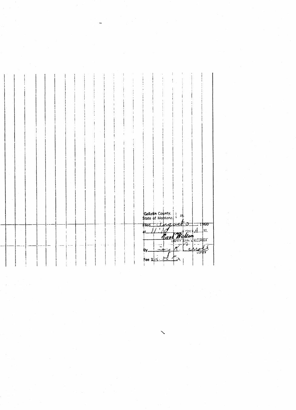
i • i ; M i i M i i i ; ; ; i i! i ! I i I \ ! i ; ! : :
1 ! ; i ' ' j i i . • i I :
I ! ! : i ! : i i ' j : ' • ' :
! ! I I ! i s ; i ! ' I i ! !
I I ' : 1 ! ' i i I i
M M ! ! i I ! ! I i II I I ! i I i i ! ! I i i i
• i : j • j ! • ! . i i ! I ;
! i M M ; ; j ; ! Mi I ; i i i ii I ! i
Mil I! | • j i !
I ' i l lI ! i ii ; ! I i i I! ! ! I i ! ! || i i I ' l l
I ! !
| i Gallatin County, | : „j i Sitate of Moitana. •
_ — | j—iuearnia^^^=^nn«o—i I # )\/ l(\& ._ .i-cloclA-.M-! ! T \^J5a*nf^Zlr-\ \ 1 j ^ 0 iUNTT i£R!» i HtCJR.iW
! ~ " ~!~" " 'I ! L ! ^^\ffX'^\A^S~
I i M l \«^¥-f*\
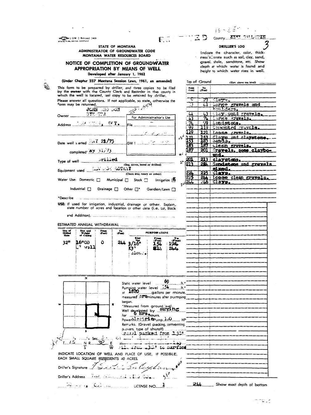
ai^^B 3 GW : Rnisoi :<K9 pp _^_ _ ^ County Sit.:_-_:...._vA.^Jf^-t.M*
STATE OF MONTANA DRILLER'S LOG 3ADMINISTRATOR OF GROUNDWATER CODE _. f h e ^ ^ c o | o r t h i c k .
MONTANA WATER RESOURCES BOARD - nesVoIsrrata such as soil, day. sand,
NOTICE OF COMPLETION OF GROUNDWATER S«« l . *ale. sandstone, eta ShowAPPROPRIATION BY MEANS OF WELL £& * « i^JS
Developed after January T, 1962
(Under Chapter 237 MoKtei* Session Laws, 1961, as amended) Top of Ground ,EICT. _bo« s« ie«o^Sgl. This form to be prepared by driller, and three copies to be filed ; Fmm I To
by the owner with the County Clerk and Recorder in the county in i 'ia0 j t r t < a ! .which the well is located, iast copy to be retained by driller. i !Please answer all questions. If not applicable, so state, otherwise the *" j <?3 '• C - l a y ^ i .farm may be returned. ^ \ 3 |_ 4 - ) UiXTpS gTSTelS and
Q w n e r DTK--TTA r-=- : 1 U , ^ j L lay-sand gravels*Fcr Administrators Use ; 43 1 7i» I I ^ fa rg yrSTTsla.
Address ____J_l_lI^__^I__ RIe Z _ 1*4*8" -&*&&&*1 99 [119 U?t*errt.r<i .mavcla-
• f. ^ , . 229 ,,_X£X T.jV*«ai» fff><ry*1oT
Date well s arted ^ A ^ . ^ . . GW 1 i_.- r_ - f _ SB-44B--^5^— -, — —
completed'*? 3l />3 . , teLAgLSJ&tS^-&&-JSl§C&ez^
Type of well ^ ^ . ^ ^ m__g3- -££XS&«**.-~(Do». driven, bomi or draied) " |21> [ 2fty SafMJofcat^ and yrowt l H
Equipment used . J ' r i i . ^ . l - i ? ^ !? Lj—Lasg-UfrWU- '" • . _ -(Chora driJ. rourj or other) icMb X.&1 I U A « f c y » »
Water Use: Domestic Q Municipal C Stock Q Irrigation g i B I ^ l ^ f g l l ^ r 1 " ^ " ^ 8 5 8 1 5 *
Industrial • Drainage Q Other • * Garden/Lawn • }•
•Describe _... 1
USE: If used for irrigation, industrial, drainage or other. Explain, Istate number of acres and location or other aata ( i .e. Lot, Block ~ r ~ j ~ ~
and Addition) L _j
ESTIMATED ANNUAL WITHDRAWAL .... \ „ |
— •••" ' 1 T \SSl5 I *&£• ' «FST) ! ,F«) PERFORATIONS . I TRate of Calnc '• \ ' —1 f"
i : Klad From To
32" |16"OD | 0 2*4 j / # ! l S iiSC0- I i:S waia| |C3 | «n> j 2hU j j
j . • ; . | I1 i i i 1 i
» ^ L .I ; I Static v/ater level „?!» ft." [
; ' Pumpiriqwater level ..ji»;ft ft.* I •J ' at *P?P . gallons per minute. !
measured* .3|*Shiinutes after pumping i __began. [ ;
w —_—_-_—_— ^ _ % » • 'H "Measured from ground |evi|l. ___
j I Well developed by ..*???*??S? T j j.: —!!•___, k for ...°...™L?.t>ours. i \
! I Powerii.?.?^riCt>urT1pJ.^O HP'~ T ! ]• ^ J Remarks: (Gravel packing, cementing, ^ !
r — ^ - ^ • • • ^ • • • • • B p..c».ers, type of shutoff) , i
•/ : r ^ / j l ?a_ka2. faan. -UQ!.. j.% . i < T . .>'* ••* sec.... i ..* ^ - -—..'--i- 1:-'- ' IX< r (.& N R 3 6 _ . _ E u. . .^5-w.__--*-^fc> • ^J s w .'i-U-_"ri^..^3ii-?-tu-.5uarfac< 1
INDICATE LOCATION OF WELL AND PLACE OF USE, IF POSSIBLE. •
EACH SMALL SQUARE REE$ESENT5 40 ACRES. • \
Driver's Signature .._^..t_^-^'..^..«."...^. •._'". * i - < C r ' r 4 ^ - ^ : < - - 1 , _ * • ••; ; . —
Driller's Address ....y.-.^.j.. r-:.r' -.-..,...,:;-..Z fcILu . C ^ * . . ^ l - . . „ . ; •-J« ~ , . , C. . I . . . LICENSE NO _ i ^ ^ Show exact depth of bottom
" ~ • ~ •- - r

Stete of Montana .• _ .County of Qallatm '
F.led___iK^K_2£_.197^
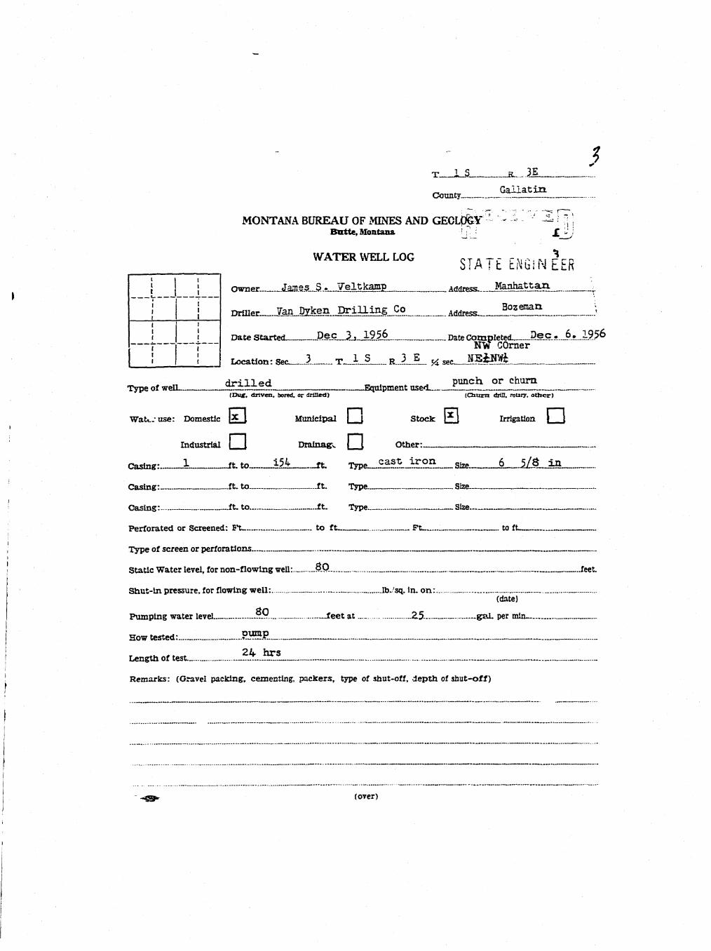
3T 1_S H_._ .21„ GallatinCounty ._
MONTANA BUREAU OF MINES AND GECL0GY * * - ^ H^iBatte, Montana : : : J[ '
WATERWELLL0G STATE ENGINEER| ; nanpr James S . Teltkamp m»i™« Manhattan. J.
j | nmim. Van Dyken D r i l l i n g Co Address_ Bozenan. ;i i
! 1 Date Started P.ec_JL_JL9l6 Date Completed 2eS-».J?.s.Jk?567 j NW COrner! ! I Location: Sec-__.i T__U K. J_i.. J4 sec J L ^ M .
drilled punch, or churnType of well g£±±±° Q Equipment used i_(Dux. driven, bored, or drilled) (QUITO drill, rotary, other)
Watt..-use: Domestic l x I Municipal j \ Stock £ j Irrigation [ J
Industrial | [ Drainage | \ Other:
Casing:—!— -ft. t o_A5i ft. Type__lf£l j£on__ size.___6__.i/8_in
Casing: .ft. to ft. Type Size
' Casing: ft. to ft. Type __SIze
Perforated or Screened: Ft — to ft — Ft to ft
, Type of screen or perforations.
i Static Water level, for non-flowing well: &Q. „„ , feet.
Shut-in pressure, for flowing well: __.lb./sq. in. on: „(date)
Pumping water level .?.9... _ —feet at J2.5- gal. per min— „„I
How tested: PH5EI 2.L. hrsI Leneth of test. _ T_ __r . . .... „._ „. _ .1 Remarks: (Gravel packing, cementing, packers, type of shut-off, depth of shut-off)
I
- ~4e$* (over)
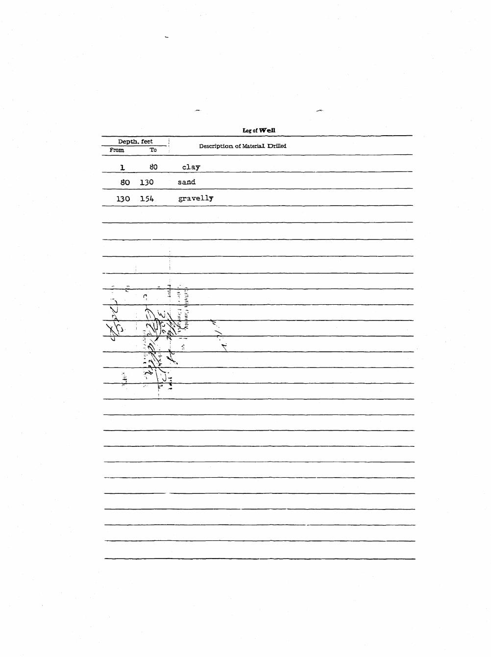
Log of Well
Deptli, feet i— — • Description, of Material Drilled
From To ;
1 tfO clay
80 130 sand
130 154 gravelly
'- " n> 1 T i
1
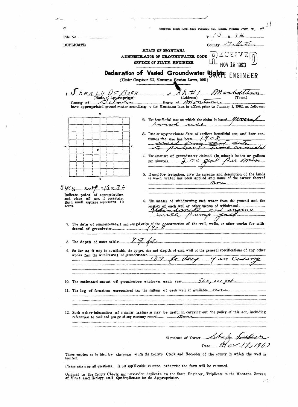
_^ __ _ _ _ __ .. , s
** " Approved Stock, Form—State Publishing Co.. Helen. Mon^uo—39089 o^_ *>3
File No T / 0 R J £
DUPLICATE County ^yr-JfL^sa.STATE OP MONTANA — N - , , - , * - , , , s
ADMINISTRATOR OP GROtTNDWATER CODE i D j ^ w ^ ^ v/ -£>! In
OFFICE OP STATS ENGINEER U u MfjU 1^ \ncft —>
Declaration o f Vested Groundwater RjgJ^: ENGi N£CR(Tinder Chapter 237, Jlontana Session -Laws, 1961)
i &hr* UU PS:/??FA t *t_J{ft.-p/ ^<™^tZt^n___(Nam&oi Apuropriator) (Address) - (Town)
County of S^s a.*£~c*^LLsn State of /firf <g-7£^tf-3>a-gc^have appropriated ground water according 'o the i lontana laws in effect prior to January 1,1962. as follows:
x
• 1 ; i l l 2 . The beneficial use on which the claim is based—•££&%i£te&j£-.
| ' • r
I • i — — - — — — — - — - - - " • " " " " - • • • • • • i • • • • - • • • -
• • '; ; ! ; 3 . Date or approximate date of earliest beneficial use; and how con-'; ! ; ; ,—— \ tinuous the use has been / . . . / ^ . .gP.—_. ;——.
j ; • ; ; ; -L The amount of groundwater claimed (in miner's inches or gallons1 1 : 1 ! ; per minute) JL~£I<2.,.£&€!*£... JTL^I—/22kf&3—! I • : i i (7 —! '• • ' • ' ' I 5. If used for irrigation, give the acreage and description of the lands
s to which, water has been applied and name of the owner thereof
{7V*crK4x'
5 _^y4___ Seci£. T./1 RJ1£ . " -" ^ ~ : - ~-Indicate point of appropriationand place of use, if possible. . , . . . i j tU
Each smaU square represents 10 6- ^^s means of withdrawing such water irom the gronnd and theacres. location of each well or other means of withdrawal ,
7. The date of commencement and completion of the construction of the well, wells, or other works for with-
drawal of groundwater_.— (...^£-J$. — -
.. .__ „ _ . Jjc...j£=f-<— —
9. So Tar as it may be available, the type, size and depth, of each well or the general specifications of any otherworks for the withdrawal of groundwater _ — —.- . •„
L2-!Z-.--~j£r.-~&££j^.~~--~-^.-.«<<tt.~C^__21 1 ~ TL £.- L ~ £ZZH
10. The estimated amount of groundwater withdrawn, each year $JZLCuj.-£.£LA'~jlk£jL*-—
11. The log of formations encountered i n the drilling of each well if available—/JACZK**.
12. Such other information of a similar nature as may be useful in carrying out *he policy of this act, includingreference to book and page of any eotinty record— ./Zkfcrws
Signature of O^er^^-,:!?^^;^-. .uJL^dt^X^
Date £b£eS^£jJ££.?Three copies to be filed by the owner wi th the County Clerk and Recorder of the county in which the well islocated.
Please answer all questions. If not applicable, so state, otherwise the form will be returned.
Original to the Connty Clerk and recorder: duplicate to the State Engineer; Triplicate to the ilontana 3ureauof Mines and Geology, and Quadruplicate for che Appropriator.