Embed Size (px)
Citation preview

STATE OF NEVADA
DEPARTMENT OF CONSERVATION AND NATURAL RESOURCES
DIVISION OF WATER RESOURCES
JASON KING, P.E.
STATE ENGINEER
DRY VALLEY (HYDROGRAPHIC BASIN 13-198)
GROUNDWATER PUMPAGE INVENTORY
WATER YEAR 2013
Field Investigated by: John Guillory, P.E. & Christi Emery
Report Prepared by: John Guillory, P.E.
i
TABLE OF CONTENTS
ABSTRACT ................................................................................................................................... 1
HYDROGRAPHIC BASIN SUMMARY ................................................................................... 2
PURPOSE AND SCOPE .............................................................................................................. 3
DESCRIPTION OF THE STUDY AREA .................................................................................. 3 FIGURE 1 LOCATION MAP OF DRY VALLEY HYDROGRAPHIC BASIN 13-198 .............. 4 GROUNDWATER LEVELS ............................................................................................................... 5
METHODS TO ESTIMATE PUMPAGE .................................................................................. 6
PUMPAGE BY MANNER OF USE ........................................................................................... 7
APPENDIX A ................................................................................................................................ 8 HISTORICAL GROUNDWATER PUMPAGE BY MANNER OF USE .......................................... 9
APPENDIX B .............................................................................................................................. 10 PERCENTAGE OF GROUNDWATER PUMPAGE WATER YEAR 2013 BY MANNER OF USE
............................................................................................................................................................ 11 GROUNDWATER PUMPAGE WATER YEAR 2013 APPROPRIATIONS vs. ACTUAL
PUMPAGE ......................................................................................................................................... 11
APPENDIX C .............................................................................................................................. 12 EXPLANATION OF COLUMN HEADINGS FOR GROUNDWATER PUMPAGE INVENTORY
............................................................................................................................................................ 13 DRY VALLEY GROUNDWATER PUMPAGE FOR WATER YEAR 2013 ................................. 14
APPENDIX D .............................................................................................................................. 18 DRY VALLEY GROUNDWATER PUMPAGE INVENTORY FIELD NOTES
FOR WATER YEAR 2013 ................................................................................................................ 19

1
ABSTRACT
This inventory represents the status and usage of all permitted, certificated and claims of
vested right groundwater rights located within Dry Valley, Hydrographic Basin 13-198, for water
year 2013 (October 1, 2012 through September 30, 2013). Also included is data associated with
depth to groundwater.
The data presented are valid for the time period of this report, and may vary from
previously published data as water rights within the basin are subject to administrative action,
such as certification, cancellation, forfeiture, or withdrawal on a daily basis.
For water year 2013 the permitted, certificated and claims of vested right groundwater
rights totaled 6,212 acre-feet. Estimated pumpage for the water year was 5,870 acre-feet.
Irrigation is the largest manner of use within the basin. For water year 2013, appropriations for
irrigation totaled 6,195 acre-feet and pumpage was 5,828 acre-feet. The next largest manner of
use was pumping by exempt domestic wells, at 30 acre-feet. Exempt domestic wells are defined
by Nevada Revised Statues 534.013 and do not require a permit issued by the State Engineer.
2
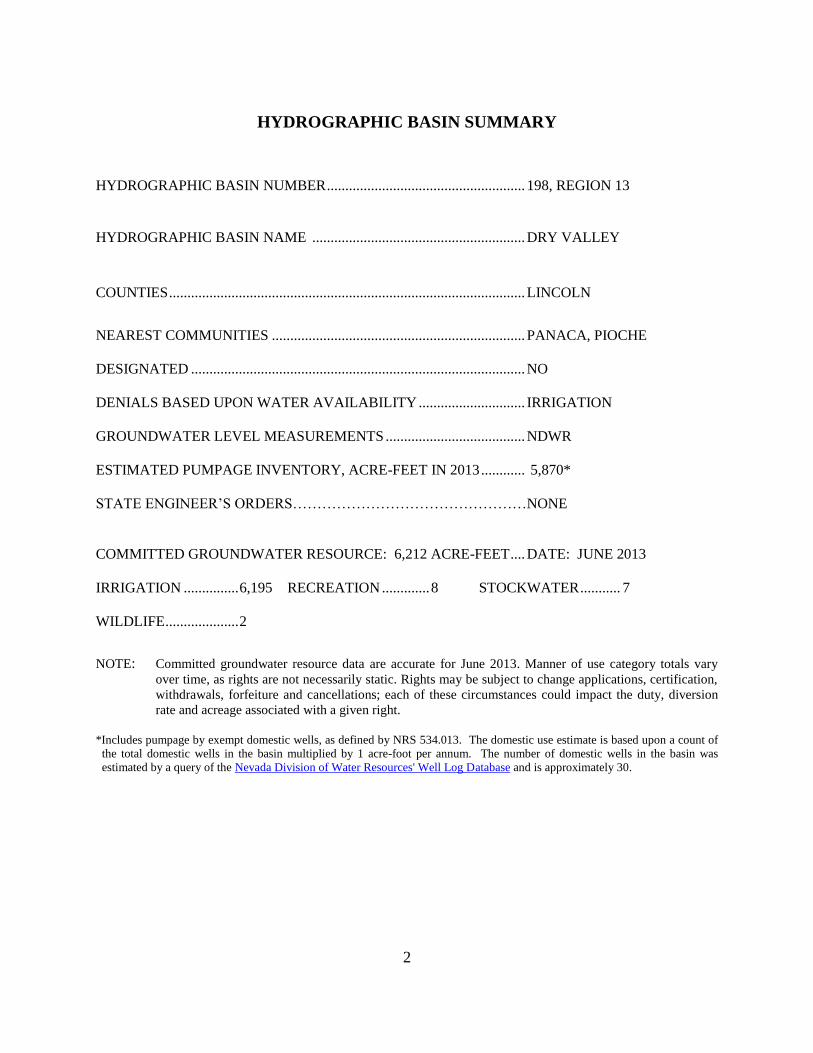
HYDROGRAPHIC BASIN SUMMARY
HYDROGRAPHIC BASIN NUMBER ...................................................... 198, REGION 13
HYDROGRAPHIC BASIN NAME .......................................................... DRY VALLEY
COUNTIES ................................................................................................. LINCOLN
NEAREST COMMUNITIES ..................................................................... PANACA, PIOCHE
DESIGNATED ........................................................................................... NO
DENIALS BASED UPON WATER AVAILABILITY ............................. IRRIGATION
GROUNDWATER LEVEL MEASUREMENTS ...................................... NDWR
ESTIMATED PUMPAGE INVENTORY, ACRE-FEET IN 2013 ............ 5,870*
STATE ENGINEER’S ORDERS………………………………………… NONE
COMMITTED GROUNDWATER RESOURCE: 6,212 ACRE-FEET .... DATE: JUNE 2013
IRRIGATION ............... 6,195 RECREATION ............. 8 STOCKWATER ........... 7
WILDLIFE .................... 2 NOTE: Committed groundwater resource data are accurate for June 2013. Manner of use category totals vary
over time, as rights are not necessarily static. Rights may be subject to change applications, certification,
withdrawals, forfeiture and cancellations; each of these circumstances could impact the duty, diversion
rate and acreage associated with a given right.
*Includes pumpage by exempt domestic wells, as defined by NRS 534.013. The domestic use estimate is based upon a count of
the total domestic wells in the basin multiplied by 1 acre-foot per annum. The number of domestic wells in the basin was
estimated by a query of the Nevada Division of Water Resources' Well Log Database and is approximately 30.

3
PURPOSE AND SCOPE
The purpose of this report is to inventory all of the groundwater resources allocated and
described by the Office of the State Engineer, Nevada Division of Water Resources, and to
estimate the amount of groundwater pumped within the Dry Valley Hydrographic Basin 13-198,
for the water year beginning October 1, 2012 and ending September 30, 2013 (hereafter referred
to as water year 2013). This report estimates the amount of groundwater pumped under the
permits and certificates issued by the State Engineer, claims of vested right, and the amount
pumped by exempt domestic wells within the basin. Associated information, such as
groundwater level measurements are also presented.
DESCRIPTION OF THE STUDY AREA
Dry Valley is a small basin located in central eastern Nevada. The valley is
approximately 10 miles east of Pioche, Nevada, and is within the Colorado River Hydrographic
Region. The basin is located within Lincoln County (see Figure 1).
Dry Valley is bounded on the east by the Needle Mountain Range and bounded on the
north by part of the Wilson Creek Range. Hamlight Canyon is on the west edge of Dry Valley.
The northwest boundary is formed by intermittent hills separating Dry Valley from Patterson
Valley. The south boundary is formed by intermittent hills separating Dry Valley from Panaca
Valley. The adjacent Nevada hydrographic basins are as follows: Panaca Valley, 13-203, to the
south; Patterson Valley, 13-202, to the west; Rose Valley, 13-199, to the north; Eagle Valley, 13-
200, to the north; and Escalante Desert, 12-197, to the east.

4
FIGURE 1 LOCATION MAP OF DRY VALLEY HYDROGRAPHIC BASIN 13-198
5
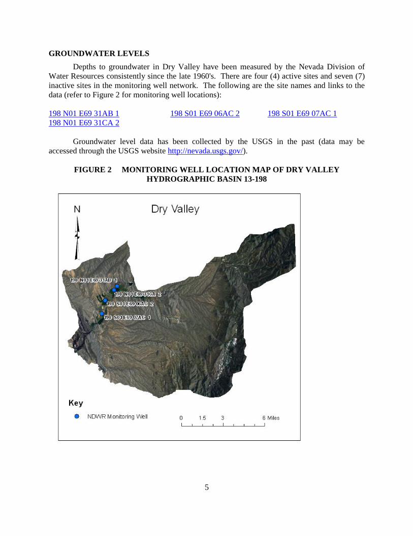
GROUNDWATER LEVELS
Depths to groundwater in Dry Valley have been measured by the Nevada Division of
Water Resources consistently since the late 1960's. There are four (4) active sites and seven (7)
inactive sites in the monitoring well network. The following are the site names and links to the
data (refer to Figure 2 for monitoring well locations):
198 N01 E69 31AB 1 198 S01 E69 06AC 2 198 S01 E69 07AC 1
198 N01 E69 31CA 2
Groundwater level data has been collected by the USGS in the past (data may be
accessed through the USGS website http://nevada.usgs.gov/).
FIGURE 2 MONITORING WELL LOCATION MAP OF DRY VALLEY
HYDROGRAPHIC BASIN 13-198
6
METHODS TO ESTIMATE PUMPAGE
This report estimates the amount of groundwater pumped under the permits and
certificates issued by the Nevada State Engineer as well as claims of vested right and exempt
domestic wells in the Dry Valley Hydrographic Basin. The following methods were used to
arrive at the estimated use:
Where totalizing meters are in place, meter readings were taken and compared with
previous data (if available).
Where meters were not in place and the use was irrigation, pumpage was estimated
by multiplying the number of hours the well was operated during the past year
(determined from an hour meter reading or asking the water user) by the certificated
diversion rate.
Where meters were not in place, use was irrigation, and the number of hours the well
was operated was unknown an inspection of the place of use was done to estimate the
amount of acreage under cultivation. The number of acres under cultivation was then
multiplied by a duty of 5 acre-feet per acre to estimate the use.
Where meters were not present, previous data were not available, and the manner of
use was not irrigation, pumpage was estimated by applying the annual duty associated
with the certificate (if the water right was perfected), permit or claim, if the use was
as described in the certificate, permit or claim. If the use was not as described in the
certificate, permit or claim, a value was estimated based upon the circumstances of
use for the subject year.
If no water was used under the certificate, permit or claim, zero use was recorded.
Exempt domestic wells may be drilled and utilized where water service from a
purveyor is not available. These types of wells do not require a permit from the State
Engineer if they do not pump more than 2 acre-feet per year as provided by Nevada
Revised Statutes (NRS) 534.180. NRS 534.013 defines this category of domestic use
as follows: “Domestic use or domestic purposes extends to culinary and household
purposes directly related to a single family dwelling, including, without limitation, the
watering of a family garden and lawn and the watering of livestock and any other
domestic animals or household pets.” The number of exempt domestic wells in the
basin is determined by a query of the Nevada Division of Water Resources' Well Log
Database. The amount of water pumped by exempt domestic wells is estimated to be
1.0 acre-foot per well in Dry Valley. Actual domestic well pumpage is not known.
7
PUMPAGE BY MANNER OF USE
Note that all data herein are estimates and are subject to revision. The total estimated
groundwater pumpage for water year 2013 was 5,870 acre-feet. The annual duties of the
certificates, permits and claims of vested right within the Dry Valley Hydrographic Basin totaled
6,212 acre-feet. The appropriated and actual pumped totals, categorized by manner of use, are
as follows:
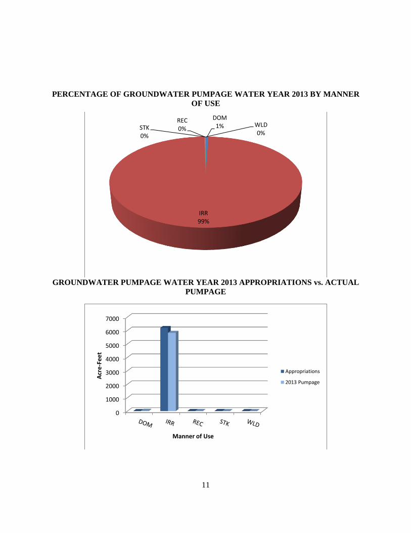
A. Irrigation (IRR)
During water year 2013, appropriations for irrigation purposes totaled 6,195 acre-feet
in the basin. An estimated 5,828 acre-feet of groundwater was pumped during water
year 2013.
B. Recreation (REC)
During water year 2013, appropriations for recreation purposes totaled 8 acre-feet in
the basin. An estimated 7 acre-feet of groundwater was pumped during water year
2013.
C. Stockwater (STK)
During water year 2013, appropriations for stockwater purposes totaled 7 acre-feet in
the basin. An estimated 4 acre-feet of groundwater was pumped during water year
2013.
D. Wildlife (WLD)
During water year 2013, appropriations for wildlife totaled 2 acre-feet in the basin.
An estimated 0 acre-feet of groundwater was pumped during water year 2013.
8
APPENDIX A
DRY VALLEY HISTORICAL PUMPAGE
9
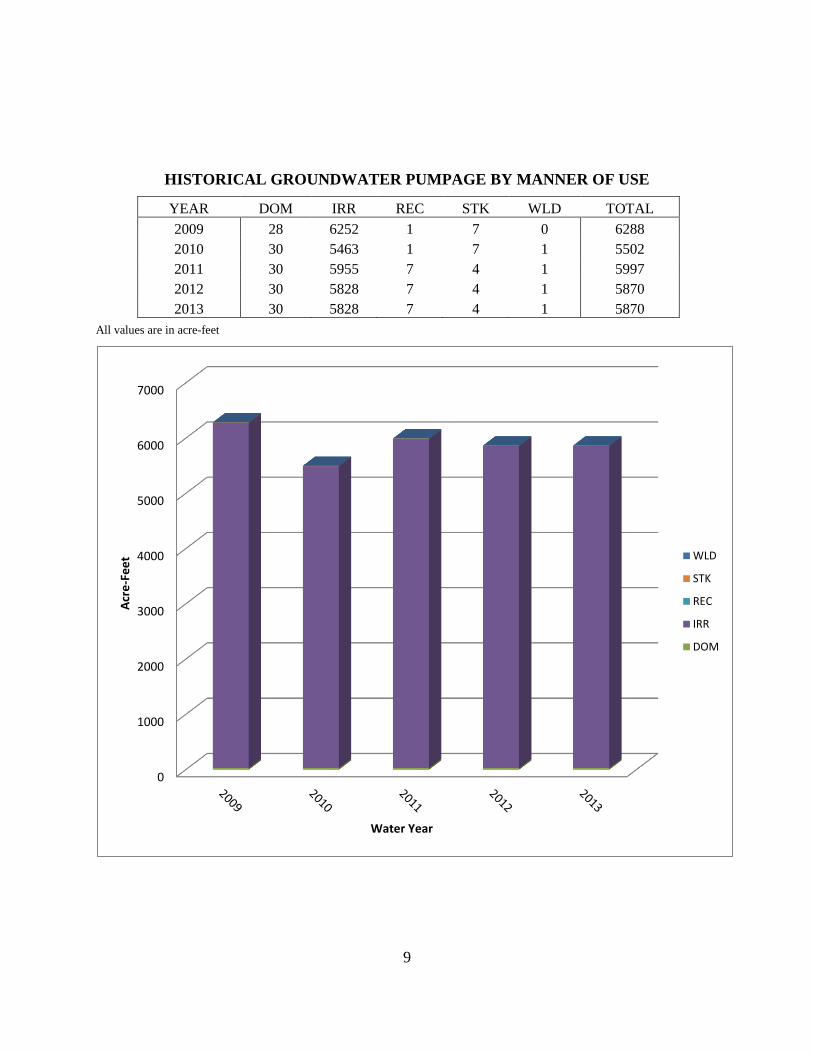
HISTORICAL GROUNDWATER PUMPAGE BY MANNER OF USE
YEAR DOM IRR REC STK WLD TOTAL
2009 28 6252 1 7 0 6288
2010 30 5463 1 7 1 5502
2011 30 5955 7 4 1 5997
2012 30 5828 7 4 1 5870
2013 30 5828 7 4 1 5870
All values are in acre-feet
0
1000
2000
3000
4000
5000
6000
7000
Acr
e-F
ee
t
Water Year
WLD
STK
REC
IRR
DOM

10
APPENDIX B
DRY VALLEY GROUNDWATER PUMPAGE FOR WATER YEAR 2013
BY MANNER OF
11
PERCENTAGE OF GROUNDWATER PUMPAGE WATER YEAR 2013 BY MANNER
OF USE
GROUNDWATER PUMPAGE WATER YEAR 2013 APPROPRIATIONS vs. ACTUAL
PUMPAGE
DOM 1%
IRR 99%
REC 0% STK
0%
WLD 0%
0
1000
2000
3000
4000
5000
6000
7000
Acr
e-F
ee
t
Manner of Use
Appropriations
2013 Pumpage

12
APPENDIX C
DRY VALLEY GROUNDWATER PUMPAGE FOR WATER YEAR 2013
13
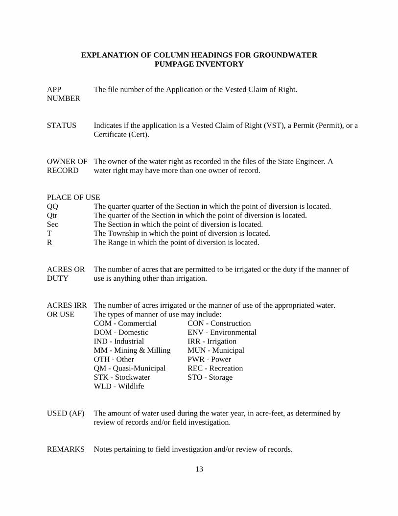
EXPLANATION OF COLUMN HEADINGS FOR GROUNDWATER
PUMPAGE INVENTORY
APP The file number of the Application or the Vested Claim of Right.
NUMBER
STATUS Indicates if the application is a Vested Claim of Right (VST), a Permit (Permit), or a
Certificate (Cert).
OWNER OF The owner of the water right as recorded in the files of the State Engineer. A
RECORD water right may have more than one owner of record.
PLACE OF USE
QQ The quarter quarter of the Section in which the point of diversion is located.
Qtr The quarter of the Section in which the point of diversion is located.
Sec The Section in which the point of diversion is located.
T The Township in which the point of diversion is located.
R The Range in which the point of diversion is located.
ACRES OR The number of acres that are permitted to be irrigated or the duty if the manner of
DUTY use is anything other than irrigation.
ACRES IRR The number of acres irrigated or the manner of use of the appropriated water.
OR USE The types of manner of use may include:
COM - Commercial CON - Construction
DOM - Domestic ENV - Environmental
IND - Industrial IRR - Irrigation
MM - Mining & Milling MUN - Municipal
OTH - Other PWR - Power
QM - Quasi-Municipal REC - Recreation
STK - Stockwater STO - Storage
WLD - Wildlife
USED (AF) The amount of water used during the water year, in acre-feet, as determined by
review of records and/or field investigation.
REMARKS Notes pertaining to field investigation and/or review of records.
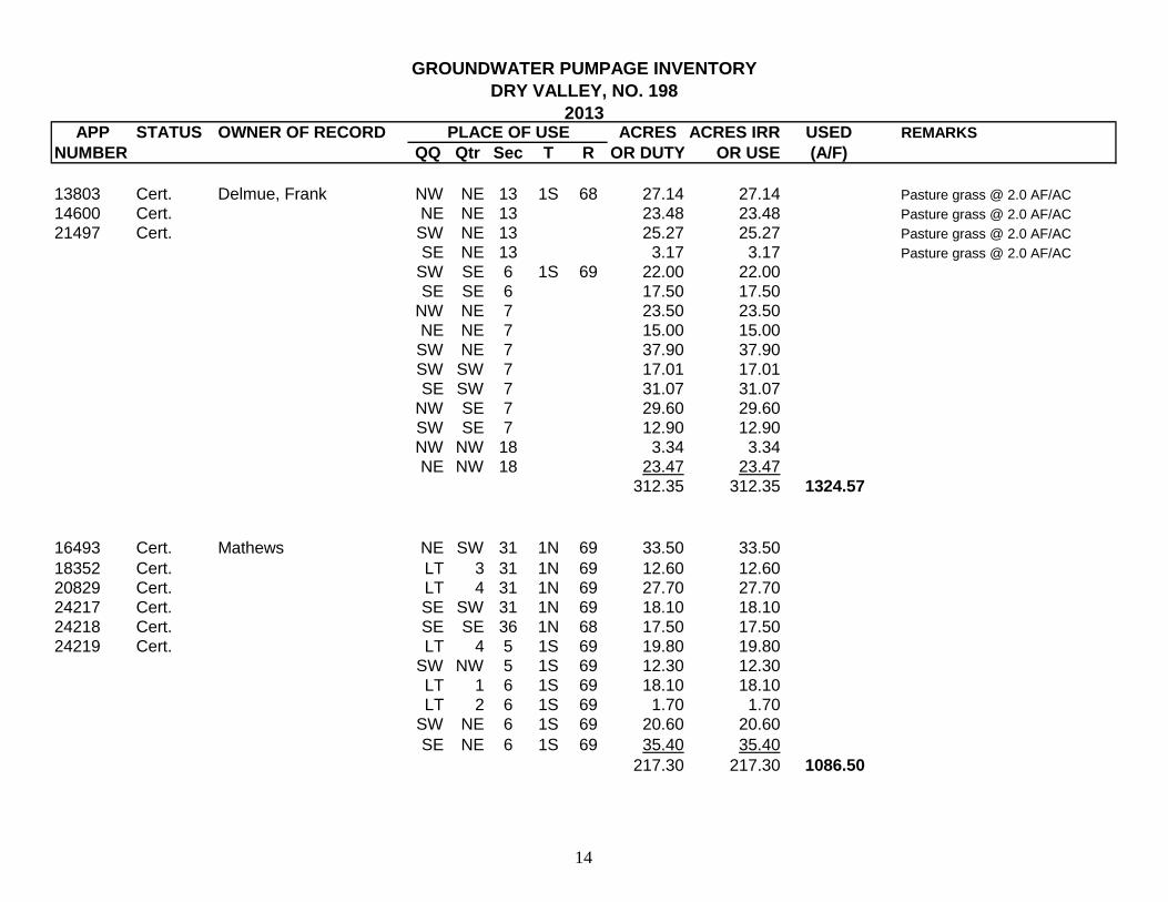
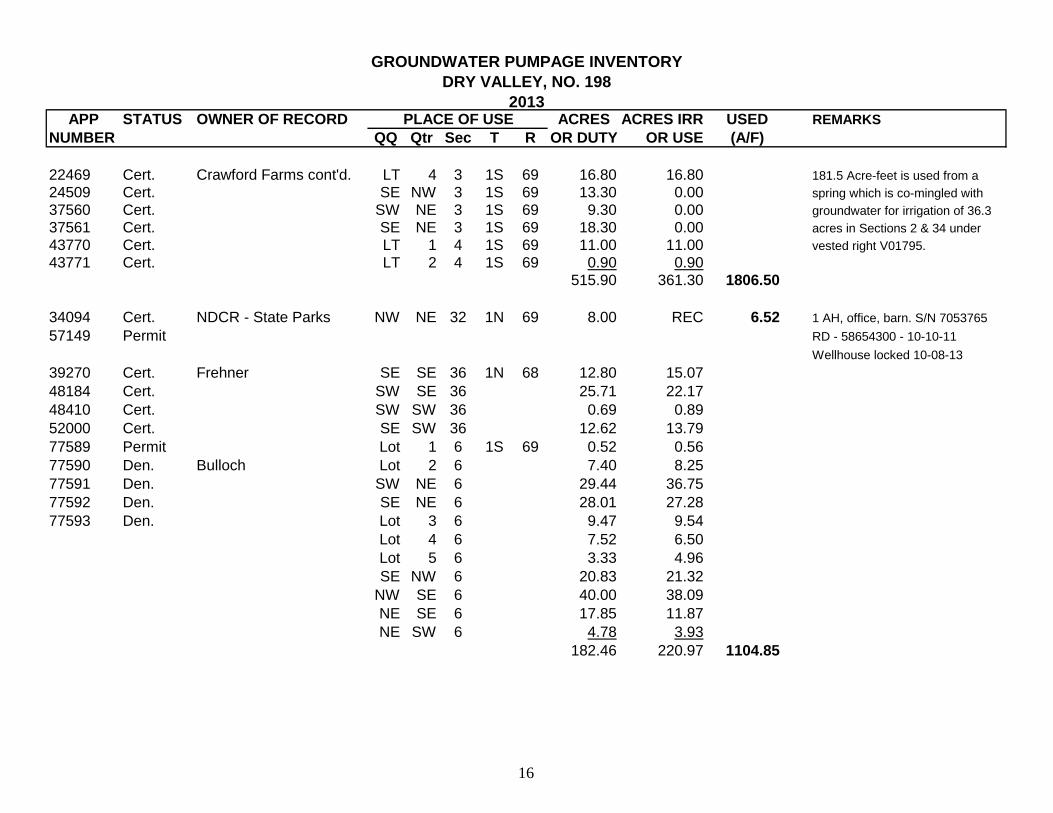
GROUNDWATER PUMPAGE INVENTORY
DRY VALLEY, NO. 198
2013APP STATUS OWNER OF RECORD PLACE OF USE ACRES ACRES IRR USED REMARKS
NUMBER QQ Qtr Sec T R OR DUTY OR USE (A/F)
13803 Cert. Delmue, Frank NW NE 13 1S 68 27.14 27.14 Pasture grass @ 2.0 AF/AC
14600 Cert. NE NE 13 23.48 23.48 Pasture grass @ 2.0 AF/AC
21497 Cert. SW NE 13 25.27 25.27 Pasture grass @ 2.0 AF/AC
SE NE 13 3.17 3.17 Pasture grass @ 2.0 AF/AC
SW SE 6 1S 69 22.00 22.00SE SE 6 17.50 17.50
NW NE 7 23.50 23.50
NE NE 7 15.00 15.00SW NE 7 37.90 37.90SW SW 7 17.01 17.01SE SW 7 31.07 31.07
NW SE 7 29.60 29.60SW SE 7 12.90 12.90NW NW 18 3.34 3.34NE NW 18 23.47 23.47
312.35 312.35 1324.57
16493 Cert. Mathews NE SW 31 1N 69 33.50 33.50
18352 Cert. LT 3 31 1N 69 12.60 12.6020829 Cert. LT 4 31 1N 69 27.70 27.7024217 Cert. SE SW 31 1N 69 18.10 18.10
24218 Cert. SE SE 36 1N 68 17.50 17.5024219 Cert. LT 4 5 1S 69 19.80 19.80
SW NW 5 1S 69 12.30 12.30LT 1 6 1S 69 18.10 18.10LT 2 6 1S 69 1.70 1.70
SW NE 6 1S 69 20.60 20.60
SE NE 6 1S 69 35.40 35.40
217.30 217.30 1086.50
14
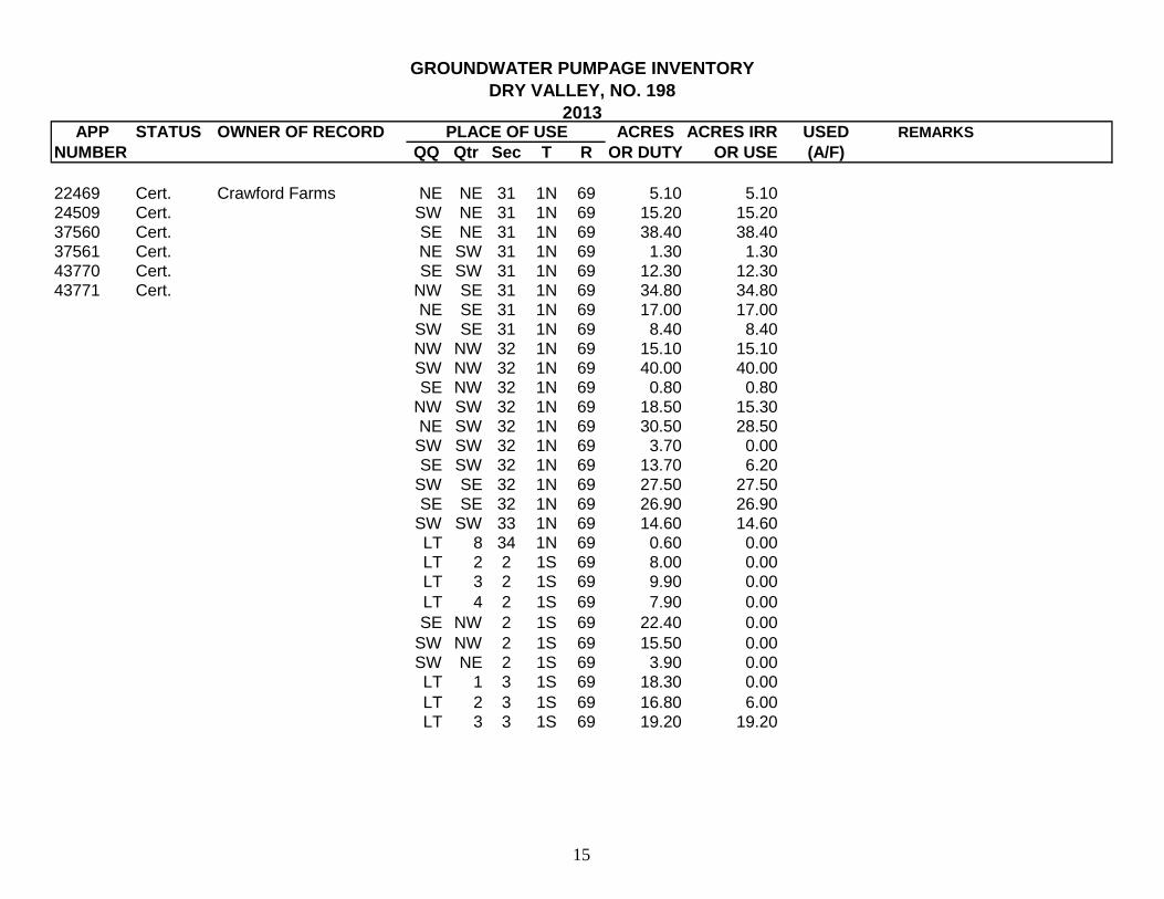
GROUNDWATER PUMPAGE INVENTORY
DRY VALLEY, NO. 198
2013APP STATUS OWNER OF RECORD PLACE OF USE ACRES ACRES IRR USED REMARKS
NUMBER QQ Qtr Sec T R OR DUTY OR USE (A/F)
22469 Cert. Crawford Farms NE NE 31 1N 69 5.10 5.1024509 Cert. SW NE 31 1N 69 15.20 15.2037560 Cert. SE NE 31 1N 69 38.40 38.4037561 Cert. NE SW 31 1N 69 1.30 1.3043770 Cert. SE SW 31 1N 69 12.30 12.3043771 Cert. NW SE 31 1N 69 34.80 34.80
NE SE 31 1N 69 17.00 17.00
SW SE 31 1N 69 8.40 8.40NW NW 32 1N 69 15.10 15.10SW NW 32 1N 69 40.00 40.00SE NW 32 1N 69 0.80 0.80
NW SW 32 1N 69 18.50 15.30NE SW 32 1N 69 30.50 28.50SW SW 32 1N 69 3.70 0.00SE SW 32 1N 69 13.70 6.20
SW SE 32 1N 69 27.50 27.50SE SE 32 1N 69 26.90 26.90
SW SW 33 1N 69 14.60 14.60LT 8 34 1N 69 0.60 0.00LT 2 2 1S 69 8.00 0.00LT 3 2 1S 69 9.90 0.00
LT 4 2 1S 69 7.90 0.00
SE NW 2 1S 69 22.40 0.00
SW NW 2 1S 69 15.50 0.00SW NE 2 1S 69 3.90 0.00LT 1 3 1S 69 18.30 0.00
LT 2 3 1S 69 16.80 6.00LT 3 3 1S 69 19.20 19.20
15
GROUNDWATER PUMPAGE INVENTORY
DRY VALLEY, NO. 198
2013APP STATUS OWNER OF RECORD PLACE OF USE ACRES ACRES IRR USED REMARKS
NUMBER QQ Qtr Sec T R OR DUTY OR USE (A/F)
22469 Cert. Crawford Farms cont'd. LT 4 3 1S 69 16.80 16.80 181.5 Acre-feet is used from a
24509 Cert. SE NW 3 1S 69 13.30 0.00 spring which is co-mingled with
37560 Cert. SW NE 3 1S 69 9.30 0.00 groundwater for irrigation of 36.3
37561 Cert. SE NE 3 1S 69 18.30 0.00 acres in Sections 2 & 34 under
43770 Cert. LT 1 4 1S 69 11.00 11.00 vested right V01795.
43771 Cert. LT 2 4 1S 69 0.90 0.90515.90 361.30 1806.50
34094 Cert. NDCR - State Parks NW NE 32 1N 69 8.00 REC 6.52 1 AH, office, barn. S/N 7053765
57149 Permit RD - 58654300 - 10-10-11
Wellhouse locked 10-08-13
39270 Cert. Frehner SE SE 36 1N 68 12.80 15.07
48184 Cert. SW SE 36 25.71 22.17
48410 Cert. SW SW 36 0.69 0.89
52000 Cert. SE SW 36 12.62 13.79
77589 Permit Lot 1 6 1S 69 0.52 0.56
77590 Den. Bulloch Lot 2 6 7.40 8.25
77591 Den. SW NE 6 29.44 36.75
77592 Den. SE NE 6 28.01 27.28
77593 Den. Lot 3 6 9.47 9.54
Lot 4 6 7.52 6.50
Lot 5 6 3.33 4.96
SE NW 6 20.83 21.32
NW SE 6 40.00 38.09
NE SE 6 17.85 11.87
NE SW 6 4.78 3.93
182.46 220.97 1104.85
16
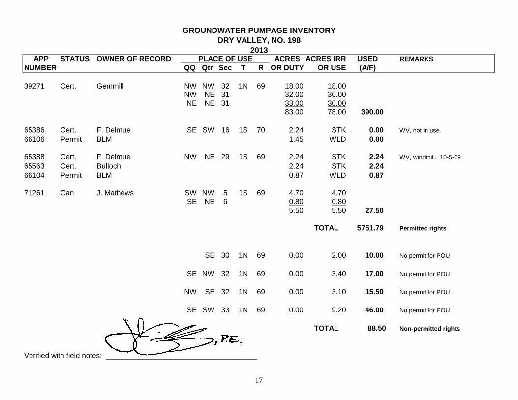
GROUNDWATER PUMPAGE INVENTORY
DRY VALLEY, NO. 198
2013APP STATUS OWNER OF RECORD PLACE OF USE ACRES ACRES IRR USED REMARKS
NUMBER QQ Qtr Sec T R OR DUTY OR USE (A/F)
39271 Cert. Gemmill NW NW 32 1N 69 18.00 18.00NW NE 31 32.00 30.00NE NE 31 33.00 30.00
83.00 78.00 390.00
65386 Cert. F. Delmue SE SW 16 1S 70 2.24 STK 0.00 WV, not in use.
66106 Permit BLM 1.45 WLD 0.00
65388 Cert. F. Delmue NW NE 29 1S 69 2.24 STK 2.24 WV, windmill. 10-5-09
65563 Cert. Bulloch 2.24 STK 2.24
66104 Permit BLM 0.87 WLD 0.87
71261 Can J. Mathews SW NW 5 1S 69 4.70 4.70SE NE 6 0.80 0.80
5.50 5.50 27.50
TOTAL 5751.79 Permitted rights
SE 30 1N 69 0.00 2.00 10.00 No permit for POU
SE NW 32 1N 69 0.00 3.40 17.00 No permit for POU
NW SE 32 1N 69 0.00 3.10 15.50 No permit for POU
SE SW 33 1N 69 0.00 9.20 46.00 No permit for POU
TOTAL 88.50 Non-permitted rights
Verified with field notes: _____________________________________
17
18
APPENDIX D
DRY VALLEY GROUNDWATER PUMPAGE INVENTORY FIELD NOTES
FOR WATER YEAR 2013
19
2013
DRY VALLEYNo. 198
Inventory Field Notes
compiled byJohn Guillory, P.E. and Christi Emery
State of NevadaDivision of Water Resources
Southern Nevada Branch Office
20
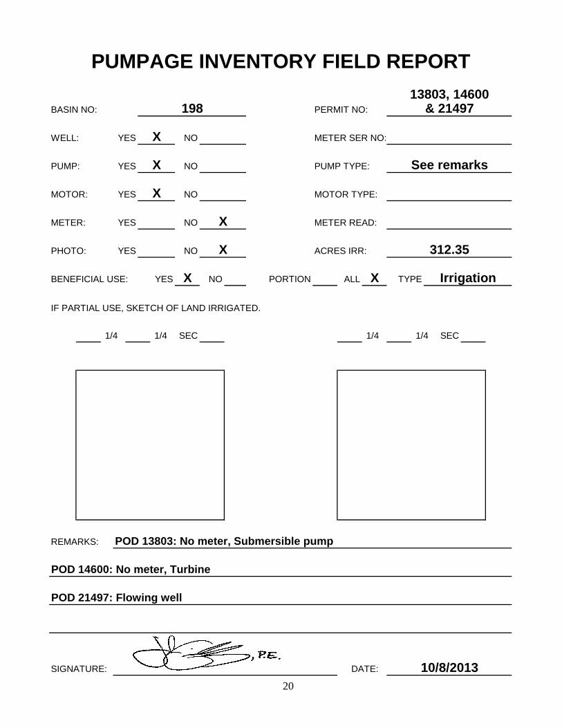
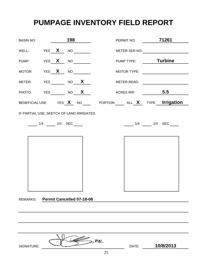
BASIN NO:
WELL: YES METER SER NO:
PUMP: YES
MOTOR: YES MOTOR TYPE:
METER: YES METER READ:
PHOTO: YES
BENEFICIAL USE: YES NO PORTION
IF PARTIAL USE, SKETCH OF LAND IRRIGATED.
REMARKS:
SIGNATURE: DATE:
POD 14600: No meter, Turbine
Irrigation
ACRES IRR:
XALL
PUMP TYPE:
13803, 14600
PUMPAGE INVENTORY FIELD REPORT
198
NO
PERMIT NO: & 21497
X
X
NO
NO
NO
NO
X
X
X
X
See remarks
TYPE
1/4 1/4
312.35
SEC
10/8/2013
POD 13803: No meter, Submersible pump
1/4 SEC1/4
POD 21497: Flowing well
21
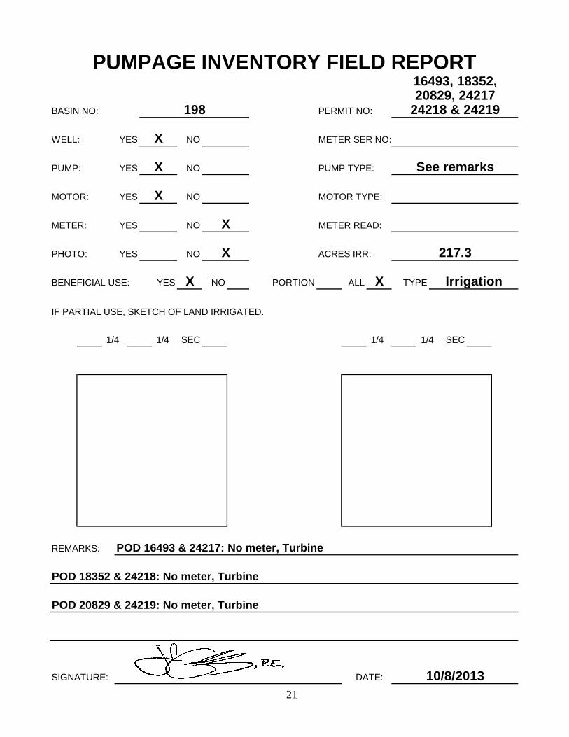
BASIN NO:
WELL: YES METER SER NO:
PUMP: YES
MOTOR: YES MOTOR TYPE:
METER: YES METER READ:
PHOTO: YES
BENEFICIAL USE: YES NO PORTION
IF PARTIAL USE, SKETCH OF LAND IRRIGATED.
REMARKS:
SIGNATURE: DATE: 10/8/2013
POD 16493 & 24217: No meter, Turbine
1/4 SEC1/4
POD 20829 & 24219: No meter, Turbine
TYPE
1/4 1/4 SEC
See remarks
217.3
X
X
X
X
X
X
NO
NO
NO
NO
PUMP TYPE:
20829, 24217
PUMPAGE INVENTORY FIELD REPORT
198
NO
PERMIT NO: 24218 & 24219
16493, 18352,
POD 18352 & 24218: No meter, Turbine
Irrigation
ACRES IRR:
XALL
22
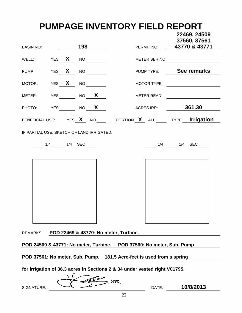
BASIN NO:
WELL: YES METER SER NO:
PUMP: YES
MOTOR: YES MOTOR TYPE:
METER: YES METER READ:
PHOTO: YES
BENEFICIAL USE: YES NO PORTION X
IF PARTIAL USE, SKETCH OF LAND IRRIGATED.
REMARKS:
SIGNATURE: DATE: 10/8/2013
POD 22469 & 43770: No meter, Turbine.
1/4 SEC1/4
POD 37561: No meter, Sub. Pump. 181.5 Acre-feet is used from a spring
TYPE
1/4 1/4 SEC
See remarks
361.30
X
X
X
X
X
X
NO
NO
NO
NO
PUMP TYPE:
37560, 37561
PUMPAGE INVENTORY FIELD REPORT
198
NO
PERMIT NO: 43770 & 43771
22469, 24509
for irrigation of 36.3 acres in Sections 2 & 34 under vested right V01795.
POD 24509 & 43771: No meter, Turbine. POD 37560: No meter, Sub. Pump
Irrigation
ACRES IRR:
ALL

23
BASIN NO:
WELL: YES METER SER NO:
PUMP: YES
MOTOR: YES MOTOR TYPE:
METER: YES METER READ:
PHOTO: YES
BENEFICIAL USE: YES NO PORTION
IF PARTIAL USE, SKETCH OF LAND IRRIGATED.
REMARKS:
SIGNATURE: DATE:
POD 77589: Well visible, S/N 3091961; RD - 00004600
POD 48184 & 52000: No meter, Turbine
Irrigation
ACRES IRR:
XALL
PUMP TYPE:
39270, 48184,
PUMPAGE INVENTORY FIELD REPORT
198
NO
PERMIT NO: 48410 & 52000
X
X
NO
NO
NO
NO
X
X
X
X
See remarks
TYPE
1/4 1/4
220.97
SEC
10/8/2013
POD 39270: No meter, Turbine
1/4 SEC1/4
POD 48410: No meter, Turbine
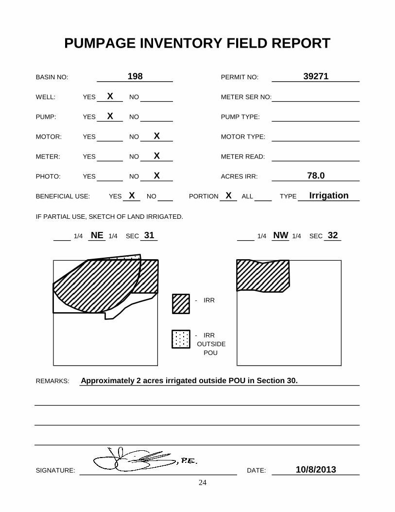
24
BASIN NO:
WELL: YES METER SER NO:
PUMP: YES
MOTOR: YES MOTOR TYPE:
METER: YES METER READ:
PHOTO: YES
BENEFICIAL USE: YES NO PORTION X
IF PARTIAL USE, SKETCH OF LAND IRRIGATED.
- IRR
- IRROUTSIDE
POU
REMARKS:
SIGNATURE: DATE:
Irrigation
NE
ACRES IRR:
ALL
PUMP TYPE:
PUMPAGE INVENTORY FIELD REPORT
198
NO
PERMIT NO: 39271
X
X
NO
NO
NO
NO
X
X
X
X
TYPE
1/4 NW 1/4
78.0
SEC 32
10/8/2013
Approximately 2 acres irrigated outside POU in Section 30.
1/4 SEC 311/4
25
BASIN NO:
WELL: YES METER SER NO:
PUMP: YES
MOTOR: YES MOTOR TYPE:
METER: YES METER READ:
PHOTO: YES
BENEFICIAL USE: YES NO PORTION
IF PARTIAL USE, SKETCH OF LAND IRRIGATED.
REMARKS:
SIGNATURE: DATE: 10/8/2013
Permit Cancelled 07-18-08
1/4 SEC1/4
TYPE
1/4 1/4 SEC
Turbine
5.5
X
X
X
X
X
X
NO
NO
NO
NO
PUMP TYPE:
PUMPAGE INVENTORY FIELD REPORT
198
NO
PERMIT NO: 71261
Irrigation
ACRES IRR:
XALL