Embed Size (px)
Citation preview
State of North Carolina 2007 Coastal and Estuarine Land
Conservation Program (CELCP) Plan
Prepared by Kelly Price and Tancred Miller
Issued by the NC Department of Environment and Natural Resources Division of Coastal Management

NC CELCP Plan 2 October 19, 2007
NC CELCP Plan 3 October 19, 2007
Executive Summary
The Federal Coastal and Estuarine Land Conservation Program (CELCP) offers coastal states cost sharing for land conservation efforts, with the funds provided through an annual competitive process among eligible states. In order to be eligible, each state must have an approved CELCP plan to represent a rational, considered approach to coastal land conservation. The State of North Carolina has prepared this plan with funding from the National Oceanographic and Atmospheric Administration (NOAA). The plan is subject to NOAA approval, and is to be updated every five years. In adherence with NOAA guidelines for preparing this plan, the state engaged in a multi-year, multi-stakeholder process, with extensive input from federal and state agencies, local governments, non-governmental organizations, academic institutions, and the general public. The state’s intent in preparing this plan was to identify the types of lands and features most in need of protection, to map the areas where these lands and features are most commonly found, and to establish a fair and open competitive funding process that facilitates their protection. Plan writers did a comprehensive search for other agencies and organizations involved in coastal land protection, gathering data from each in order to arrive at a state consensus of the highest priority areas for conservation. To the extent possible, the plan incorporates the existing efforts and priorities of those organizations. North Carolina applicants for funding through the CELCP are advised to refer to this plan in preparing their applications, as the plan identifies project focus areas and the criteria that will be used to rate their applications. Applications that do not support the goals of this plan may not be competitive at the state and federal levels. Successful applications will be advanced to the federal competitive process.

NC CELCP Plan 4 October 19, 2007
[This page intentionally left blank]
NC CELCP Plan 5 October 19, 2007
Acknowledgments
North Carolina’s Coastal and Estuarine Conservation Program Plan was developed with funding assistance from the United States National Oceanic and Atmospheric Administration’s (NOAA) Office of Ocean and Coastal Resource Management (OCRM) and the North Carolina Department of Environment and Natural Resources (NC DENR). Plan development was administered through the NC Department of Environment & Natural Resources (DENR), Division of Coastal Management. We are grateful for the extensive input, data, technical guidance, review, and general assistance that were received from many individuals and organizations in preparation of this plan. We apologize for any names that were inadvertently omitted from this list, your contribution was still very much appreciated.
Members of the Coastal Resource Commission and Coastal Resources Advisory Council
Division of Coastal Management: Charles Jones, Steve Underwood, Mike
Lopazanski, Guy Stefanski, Michele Walker, Jaye Poole (DENR)
North Carolina Coastal Reserves: Rebecca Ellin, John Fear, Michele Droszcz, Woody Webster
Office of Conservation & Community Affairs: Richard Rogers, Bill Crowell (APNEP),
Scott Pohlman (NHP)
The Nature Conservancy: Dan Bell, Sandra Cavalieri, Aaron McCall
NC Coastal Land Trust: Camilla Herlevich, Janice Allen, Lee Leidy, Michael Scisco
Wildlife Resource Commission: Shannon Deaton, Carol Price
Members of the Cape Fear Arch Collaborative
Partnership for the Sounds: Tom Stroud
NC Center for Geographic Information and Analysis: Jeff Brown
Conservation Trust for NC: Lisa Creasman
NOAA, Office of Ocean and Coastal Resource Management: Elaine Vaudreuil, Elisabeth Morgan

NC CELCP Plan 6 October 19, 2007
[This page intentionally left blank]
NC CELCP Plan 7 October 19, 2007
Table of Contents
I. INTRODUCTION......................................................................................9
A. BACKGROUND ........................................................................................................... 9
B. PURPOSE OF A COASTAL AND ESTUARINE LAND CONSERVATION PROGRAM (CELCP)
PLAN ..................................................................................................................... 11
II. COASTAL AND ESTUARINE LAND PROTECTION PRIORITIES .....13
A. GEOGRAPHIC EXTENT OF COASTAL AND ESTUARINE AREAS WITHIN NORTH CAROLINA.. 13
B. LANDS AND VALUES TO PROTECT THROUGH NORTH CAROLINA’S CELCP PLAN ........... 14
C. IDENTIFICATION OF PROJECT AREAS ......................................................................... 17
D. DESCRIPTION OF EXISTING PLANS ............................................................................ 24
State and State-Federal Government Programs and Plans................................................25
Non-Profit Organization & Public-Private Partnership Programs and Plans .......................36
III. STATE PROCESS FOR IMPLEMENTING THE CELCP ....................41
A. IDENTIFICATION OF STATE LEAD AGENCY.................................................................... 41
B. AGENCIES ELIGIBLE TO HOLD TITLE TO PROPERTY ACQUIRED THROUGH THE CELCP .... 41
C. STATE NOMINATION PROCESS .................................................................................. 42
Solicitation of Projects.........................................................................................................42
State Review and Prioritization ...........................................................................................42
IV. COORDINATION AND PUBLIC INVOLVEMENT...............................52
A. INTERAGENCY COORDINATION DURING PLAN DEVELOPMENT ....................................... 52
B. PUBLIC INVOLVEMENT IN PLAN DEVELOPMENT ............................................................ 52
V. CERTIFICATION AND APPROVAL ....................................................55
VI. REFERENCES ....................................................................................56

NC CELCP Plan 8 October 19, 2007
[This page intentionally left blank]
NC CELCP Plan 9 October 19, 2007
I. Introduction A. Background Land conservation is a high priority for the State of North Carolina and its citizens, as much in the coastal zone as in other parts of the State. The North Carolina Constitution declares that, “It shall be the proper function of the State to acquire and preserve park, recreational and scenic areas, and in every other appropriate way, to preserve as a part of the common heritage of this State, its open lands and places of beauty.” This constitutional provision is the basis for the State’s Coastal Area Management Act (CAMA) of 1974.
CAMA declares North Carolina's coastal area to be among the most valuable and biologically productive regions of the State, and to have an extremely high recreational and esthetic value that should be preserved and enhanced. In crafting CAMA, the General Assembly found an immediate and pressing need to establish a comprehensive plan for the protection, preservation, orderly development, and management of the coastal area.
The law directs that the public's opportunity to enjoy the physical, esthetic, cultural, and recreational qualities of the natural shorelines of the State shall be preserved to the greatest extent feasible; that water resources shall be managed in order to preserve and enhance water quality and to provide optimum utilization of water resources; that land resources shall be managed in order to guide growth and development and to minimize damage to the natural environment; and that private property rights shall be preserved in accordance with the state and federal constitutions.
The goals of the NC Coastal Management Program (NCCMP) created pursuant to CAMA include:
♦ Preserving and managing the natural ecological conditions of the estuarine system, the barrier dune system, and the beaches, so as to safeguard and perpetuate their natural productivity and their biological, economic and esthetic values;
♦ Ensuring that the development or preservation of the land and water resources of the coastal area proceeds in a manner consistent with the capability of the land and water for development, use, or preservation based on ecological considerations;
♦ Ensuring the orderly and balanced use and preservation of the State’s coastal resources on behalf of the people of North Carolina and the nation;
Relevant NCCMP policies, guidelines and standards were established under CAMA for:
♦ Protection, preservation, and conservation of natural resources including but not limited to water use, scenic vistas, and fish and wildlife; and management of areas of significant natural value;
NC CELCP Plan 10 October 19, 2007
♦ Recreation and tourist facilities and parklands;
♦ Preservation and enhancement of the historic, cultural, and scientific aspects of the coastal area;
♦ Protection of present common-law and statutory public rights in the lands and waters of the coastal area.
North Carolina contains the second largest estuarine system in the country with a coastline extending 320 miles in length, an estuarine shoreline extending over 4,000 miles in length, and a coastal zone comprised of about 9,363 square miles. The State is committed to providing open space and access to its residents and many visitors, and to protecting the unique and complex ecosystems that make its coastal zone so productive and remarkable. In 2000, under Governor Jim Hunt, the North Carolina General Assembly codified the aggressive goal to “encourage, facilitate, plan, coordinate, and supports appropriate federal, State, local and private land protection efforts so that an additional one million acres of farmland, open space, and conservation lands” would be permanently protected within the State by 2010. The State’s five citizen-guided trust fund programs, some established since 1986 by the General Assembly, carry out this Million Acre Initiative by providing matching funds for this purpose. The Agricultural Development and Farmland Preservation Trust Fund (AGFPTF), created in 1986, has protected working farms on prime soils that provided important economic and ecological benefits to the State through grants made to land trusts, local governments, and non-profits. This program suffered budget cuts in 2003, but in 2005, FPTF received funding from the NC General Assembly to establish acquisition goals and implementation actions for future funding activities. The Natural Heritage Trust Fund (NHTF) since 1987 has provided supplemental funding to select state agencies for the acquisition and protection of important natural areas, to preserve the State’s ecological diversity and cultural heritage, and to inventory the natural heritage resources of the State. Natural lands are acquired for state parks, preserves, game lands, wildlife conservation areas, coastal reserves, natural and scenic rivers, historic site properties, and other outdoor recreation and natural areas. Funding priorities are given to projects that will protect areas of state or national ecological significance or outstanding cultural significance. The Parks and Recreation Trust Fund (PARTF) since 1994 has funded improvements in the State’s park system, such as the construction or renovation of facilities, and the purchase of land for new or existing state parks and natural areas. PARTF has also provided grants to local governments to increase the public’s access to the State’s beaches through the Public Beach and Coastal Waterfront Access Program administered by the Division of Coastal Management. The Clean Water Management Trust Fund (CWMTF) since 1996 has helped local governments, state agencies, and conservation non-profit groups finance projects to enhance or restore degraded waters, protect unpolluted waters, and contribute toward a network of riparian buffers and greenways for environmental, educational, and recreational benefits. 57 percent of funds distributed by CWMTF between 1997 and 2005 have been for land acquisition of buffers, wetlands, floodplains, and greenways.
NC CELCP Plan 11 October 19, 2007
The Ecosystem Enhancement Program (EEP), formerly the Wetlands Restoration Program, was developed through a 2003 Memorandum of Agreement between the NC DENR, the NC Department of Transportation (DOT), and the US Army Corps of Engineers. EEP has a huge potential to dictate future land acquisitions in North Carolina through a watershed protection approach to compensatory mitigation from unavoidable impacts to stream and wetlands associated with highway development projects. Funding for these five funding programs has fallen short in recent years, and North Carolina is behind in its Million Acre conservation goal. Participation in programs such as the Coastal and Estuarine Land Conservation Program will help North Carolina achieve this goal. The rapid pace of population growth and development presents a challenge for attaining the one million acre goal set forth in the Million Acre Initiative. The coastal population grew by about 15 percent between 1990 and 2000 (US Census Bureau). In 2002, the North Carolina Public Interest Research Group (NCPIRG) estimated that an additional 34 percent to 43 percent of land within the coastal counties will become developed by 2022. Conversion of forests, wetlands, agricultural lands, and other natural areas will have a negative impact on sustaining ecological function, water quality protection, critical wildlife habitat, outdoor recreation and tourism, scenic beauty, historic places, and lands that preserve the natural heritage of North Carolina. The State of North Carolina does not currently have a comprehensive land conservation plan for the coastal zone. A number of statewide efforts have identified potential conservation areas through their planning processes, however. Both public and private interests are realizing the threats to the State’s natural coastal resources that come with a growing population and intensifying development. Regional coastal conservation plans are developing as these interested parties are taking a collaborative approach to identifying conservation priorities for acquisition.
B. Purpose of a Coastal and Estuarine Land Conservation Program (CELCP) Plan
The Department of Commerce, Justice, and State Appropriations Act of 2002 (Public Law 107-77), directed the Secretary of Commerce to establish a Coastal and Estuarine Land Conservation Program for the purpose of protecting important coastal and estuarine areas that have significant conservation, recreation, ecological, historical, or aesthetic values, or that are threatened by conversion from their natural or recreational state to other uses, giving priority to lands which can be effectively managed and protected and that have significant ecological value. North Carolina’s CELCP Plan follows the federal guidelines directing the content, development, and implementation of state CELCP plans, accessible from NOAA-OCRM at, http://www.coastalmanagement.noaa.gov/land/welcome.html.
The State of North Carolina has prepared this Coastal and Estuarine Land Conservation Program (CELCP) plan in order to participate in the competitive federal grant funding program for coastal and estuarine land conservation. A federally-approved State plan is a pre-requisite for participating in the program. To date, grant awards have been distributed through Congressional appropriations, however North Carolina projects have not been funded through this process. Competitive funding is anticipated for FY 2007 and thereafter.
NC CELCP Plan 12 October 19, 2007
The Plan presented here serves two purposes. The first is to satisfy requirements for federal program participation. The second is to create a comprehensive land conservation plan for North Carolina’s coastal zone, because at present, one does not exist. Many state agencies, local governments, and conservation non-profits have conservation plans with overlapping objectives. This CELCP Plan combines the work of these organizations into one comprehensive document and details where CELCP funding will help them advance their conservation goals. The CELCP Plan provides an assessment of priority conservation needs within the coastal zone. It also serves as a guide for project applicants and evaluators in the selection and nomination of coastal and estuarine land conservation projects within the state of North Carolina. This guidance document outlines project eligibility requirements; coast-wide priority focus areas for conservation; existing state and regional acquisition plans consistent with the goals of CELCP and CAMA; and a description of the State’s evaluation criteria and scoring system to be utilized by the Division of Coastal Management in ranking North Carolina project applications that will compete at the national level for funding.
NC CELCP Plan 13 October 19, 2007
II. Coastal & Estuarine Land Protection Priorities A. Geographic Extent of Coastal and Estuarine Areas within
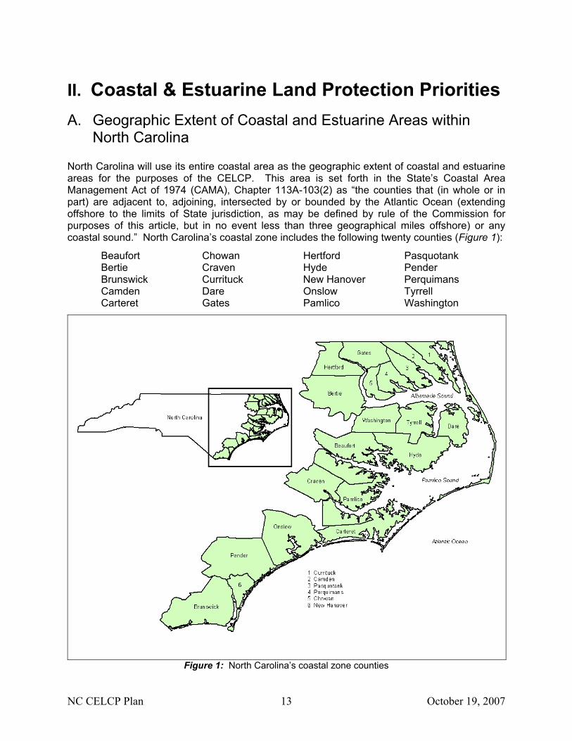
North Carolina North Carolina will use its entire coastal area as the geographic extent of coastal and estuarine areas for the purposes of the CELCP. This area is set forth in the State’s Coastal Area Management Act of 1974 (CAMA), Chapter 113A-103(2) as “the counties that (in whole or in part) are adjacent to, adjoining, intersected by or bounded by the Atlantic Ocean (extending offshore to the limits of State jurisdiction, as may be defined by rule of the Commission for purposes of this article, but in no event less than three geographical miles offshore) or any coastal sound.” North Carolina’s coastal zone includes the following twenty counties (Figure 1): Beaufort Chowan Hertford Pasquotank Bertie Craven Hyde Pender Brunswick Currituck New Hanover Perquimans Camden Dare Onslow Tyrrell Carteret Gates Pamlico Washington
Figure 1: North Carolina’s coastal zone counties
NC CELCP Plan 14 October 19, 2007
B. Lands and Values to be Protected through North Carolina’s CELCP Plan
North Carolina is experiencing unprecedented development within its coastal zone. In-state relocation, in-migration from other states, and real estate investment all contribute to this growth. As a result, both pristine lands and working lands are being converted at a rapid rate, and ecological, recreational, and “quality of life” values are diminishing. North Carolina also has a significant military presence in its coastal zone, and while these areas may protect some ecological values, public use is severely restricted or prohibited. Social Values North Carolina holds its public trust rights as a common heritage and a primary conservation value. These include the right of the public to have natural land available and accessible for their use and enjoyment, and the right of access to the public waters of the state. These rights have historically been ensured through a complex of federal, state, local, commercial, and private interests. However, an artifact of the State’s changing coastal culture has been a growing battle to elevate private property rights over the public trust. As more coastal lands become privatized and developed, opportunities for public trust access and enjoyment diminish. North Carolina’s coastal land conservation efforts must continue to prioritize the protection of public trust rights. Other social values that can be protected and enhanced through land conservation include education, improvements to public health, preservation of historic or cultural areas, public access, and aesthetic natural areas. Ecological Values Ecological values are difficult to define and vary with multiple parameters. The State has a large variety of habitat types each with different conservation priorities. Conservation priority is a product of habitat suitability, habitat abundance, diversity of species supported, the listed species supported, the present condition, the present use, the threat of conversion, and the area of the habitat type that is already in conservation. Maintaining ecosystem function, retaining biodiversity, protecting water quality, building ecological corridors and greenways, and minimizing habitat lost to erosion through vegetative shoreline stabilization are examples of priority ecological values. Lands To Be Protected Wetlands provide many ecological benefits, including pollution buffering, wildlife habitat, and storm surge buffering. Coastal wetlands, including marshes, riverine wetlands, pocosins, and small depression wetlands, shall be one of the state’s priority project areas. Wetlands have a high threat of conversion, despite legal and regulatory protections. Wetlands are often considered an inconvenience and impediment to development, and continue to be filled in order to accommodate construction. Wetlands are also being rapidly drowned and lost due to erosion and sea level rise and/or subsidence. It is estimated that more than 50 percent of North Carolina’s historic wetlands have been lost. Coastal forests, such as maritime forests, coastal fringe forests, bottomland floodplain forests, mesic and dry hardwood forests, non-riverine wet hardwood forests, swamp forests, wet marl forests, and long-leaf pine savannas, have high ecological value since they support high species abundance and diversity. Coastal forests are limited in North Carolina, and most of the remaining forests are under federal or commercial ownership. The state is seeing regular transfer of working forests to development interests. The tracts are frequently subdivided and
NC CELCP Plan 15 October 19, 2007
built upon. Southern forests are among the richest in terms of the total number of species of plants and animals. Agriculture and forestry are multi-billion dollar industries in North Carolina, yet the State is a leader among the 50 states in annual loss of working farms and forests. Acquiring coastal forestlands for conservation is therefore another state priority. Land that is in active farming or agricultural production is not eligible for conservation funding under the CELCP Guidelines, but the State will continue to protect working lands under other appropriate programs such as the USDA Forest Legacy Program, and the Farm & Ranch Land Protection Program. Oceanfront lands as part of barrier island complexes, and riparian lands—particularly those lands adjacent to high quality waters (HQW) typically have high conservation values from an ecological and a social perspective. The highest conversion pressure exists on waterfront lands because of their aesthetic value and guaranteed water access. Conserving these lands will help to ensure access to public trust waters. Waterfront lands also possess very high ecological value. These lands may provide nesting and forage habitat to a variety of avian, terrestrial, and amphibious species. These areas also provide important buffering services to protect surface waters and aquatic life from stormwater pollution. Barrier and estuarine island communities, including beach and dune systems, serve as protective features that reduce the impact of flooding and erosion from storms. Minimizing development on barrier islands minimizes hurricane damage and maintains areas of natural beauty. These vulnerable ecosystems are also home to many rare plants, animals, and natural communities, some which are globally restricted. Floodplains and upland areas that serve as buffers are also considered targets for conservation. Riverine floodplains, natural lake shorelines, and blackwater and brownwater floodplains (including cypress-gum swamps, bottomland hardwoods, and freshwater tidal marshes) support highly diverse and rare plant and animal communities, serve as critical breeding habitats, are important for migratory birds, and are especially vulnerable to land use changes. These floodplains also support ecologically important aquatic habitats along rivers, natural lakes, and estuaries. Conservation of floodplains and riparian areas are important for water quality protection and maintaining health of our aquatic resources. Wildlife preserves and game lands provide inherent ecological value since they are preserved primarily to provide appropriate wildlife habitat. Preserves and game lands offer varying levels of public access and uses, but public uses are typically secondary to habitat quality and ecological function. Trails, greenways, and urban greenspaces are frequently overlooked in fiscal allocations at the local level. The primary purposes of these areas are typically aesthetic and recreational, yet they may provide significant conservation benefit at the local scale. Culturally significant areas include important historic and archeological sites, and natural or cultural heritage areas. These areas are often lost or fragmented by development, and preservation funding is extremely limited. Coastal plain marl outcrops are calcium carbonate-rich deposits, typically bound together by clay. Marl is extremely rare in North Carolina, and where it occurs it provides habitat for several threatened and endangered species. Marl outcrops can be found in the intertidal zone as well as in inland areas of the coastal zone, and are very susceptible to damage.
NC CELCP Plan 16 October 19, 2007
Prioritization of Conservation Needs Land conservation within the coastal region has been a product of the dedicated work of federal, state and local governments, land trusts, and other non-governmental conservation organizations. Much of the work of these organizations and agencies is encapsulated into existing regional conservation plans as described in Section D of this document. In recognition of the enormous value of these earlier and ongoing efforts, the State has drawn heavily from existing plans in outlining priority conservation needs. The State will prioritize projects that serve the following conservation needs:
Contribution to an Ecological Network • Protects relatively pristine areas of ecological significance such as old-growth forests
or pristine wetlands, and provides connections or contiguous additions to other protected areas.
Contribution to the Conservation Goals of Existing Plans
• Advances the acquisition and protection targets identified through multi-stakeholder processes and formalized into a regional or state-level conservation plan.
Protection of State Natural Heritage Areas
• Targets the coastal sites identified by the NC Natural Heritage Program as Significant Natural Heritage Areas (SNHAs). These areas are widely regarded by governmental agencies and conservation organizations as among the highest targets for protection.
Creation of Riparian Buffers
• Creates development buffers, particularly around high quality and other designated waters. High quality waters (HQW) are classified by the NC Division of Water Quality and are afforded the highest levels of protection by the State. Other designated waters include the NC Division of Marine Fisheries Primary Nursery Areas (existing) and Strategic Habitat Areas (to be designated).
Supply of Public Access and Recreation
• Increases the opportunities for public access to and enjoyment of coastal natural areas. Public access and recreation areas may be identified, for example, in local land use plans or by state agencies.
Protection of Underrepresented Ecological Themes
• Acquires or protects resource themes that the NC Division of Parks and Recreation has identified in their New Parks for a New Century plan as significant ecological areas that are underrepresented in the system of state parks and protected areas. Additional consideration will be given based upon scarcity of the resource theme and the threat of conversion.
Protection of Important Wildlife Areas
• Protects and connects critical wildlife habitat, including Audubon’s Important Bird Areas (IBAs) and targets identified in the Wildlife Resources Commission’s Wildlife Action Plan.
NC CELCP Plan 17 October 19, 2007
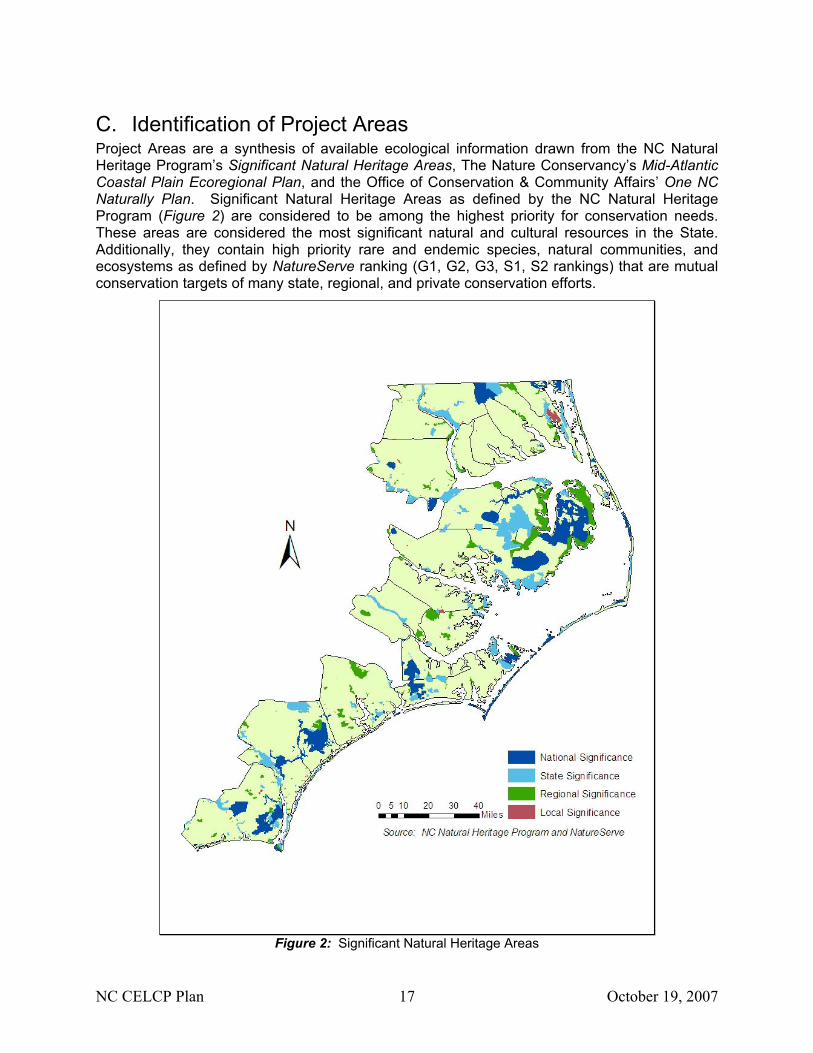
C. Identification of Project Areas Project Areas are a synthesis of available ecological information drawn from the NC Natural Heritage Program’s Significant Natural Heritage Areas, The Nature Conservancy’s Mid-Atlantic Coastal Plain Ecoregional Plan, and the Office of Conservation & Community Affairs’ One NC Naturally Plan. Significant Natural Heritage Areas as defined by the NC Natural Heritage Program (Figure 2) are considered to be among the highest priority for conservation needs. These areas are considered the most significant natural and cultural resources in the State. Additionally, they contain high priority rare and endemic species, natural communities, and ecosystems as defined by NatureServe ranking (G1, G2, G3, S1, S2 rankings) that are mutual conservation targets of many state, regional, and private conservation efforts.
Figure 2: Significant Natural Heritage Areas
NC CELCP Plan 18 October 19, 2007
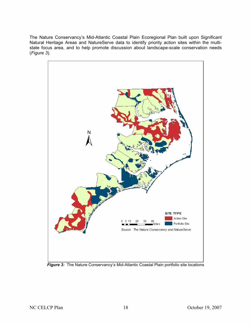
The Nature Conservancy’s Mid-Atlantic Coastal Plain Ecoregional Plan built upon Significant Natural Heritage Areas and NatureServe data to identify priority action sites within the multi-state focus area, and to help promote discussion about landscape-scale conservation needs (Figure 3).
Figure 3: The Nature Conservancy’s Mid-Atlantic Coastal Plain portfolio site locations
NC CELCP Plan 19 October 19, 2007
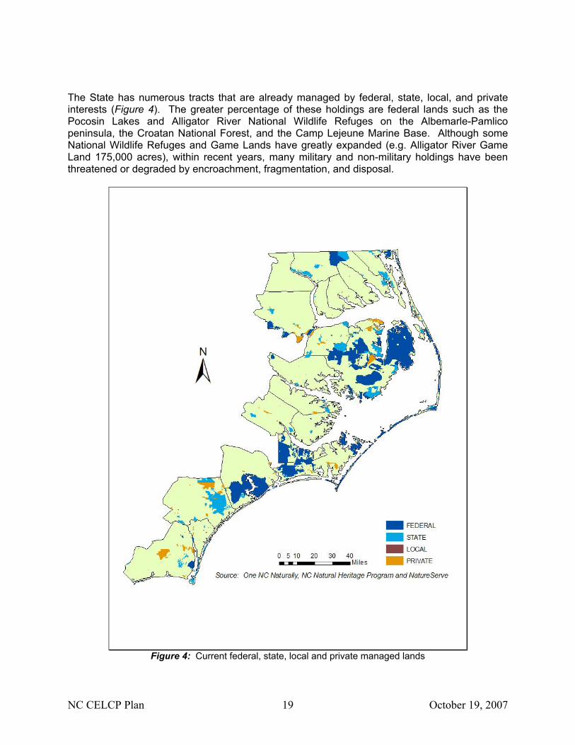
The State has numerous tracts that are already managed by federal, state, local, and private interests (Figure 4). The greater percentage of these holdings are federal lands such as the Pocosin Lakes and Alligator River National Wildlife Refuges on the Albemarle-Pamlico peninsula, the Croatan National Forest, and the Camp Lejeune Marine Base. Although some National Wildlife Refuges and Game Lands have greatly expanded (e.g. Alligator River Game Land 175,000 acres), within recent years, many military and non-military holdings have been threatened or degraded by encroachment, fragmentation, and disposal.
Figure 4: Current federal, state, local and private managed lands
NC CELCP Plan 20 October 19, 2007
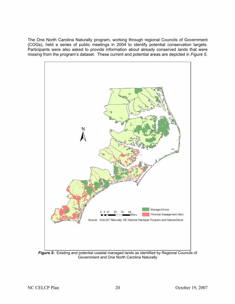
The One North Carolina Naturally program, working through regional Councils of Government (COGs), held a series of public meetings in 2004 to identify potential conservation targets. Participants were also asked to provide information about already conserved lands that were missing from the program’s dataset. These current and potential areas are depicted in Figure 5.
Figure 5: Existing and potential coastal managed lands as identified by Regional Councils of
Government and One North Carolina Naturally
NC CELCP Plan 21 October 19, 2007
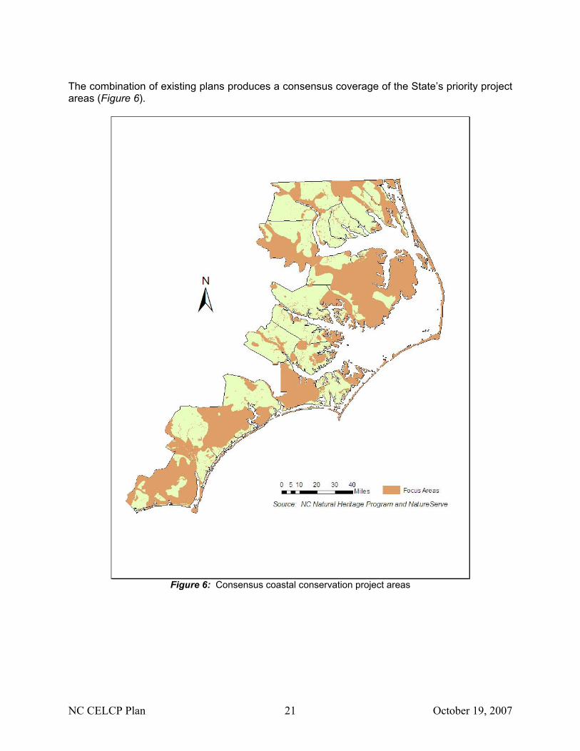
The combination of existing plans produces a consensus coverage of the State’s priority project areas (Figure 6).
Figure 6: Consensus coastal conservation project areas
NC CELCP Plan 22 October 19, 2007
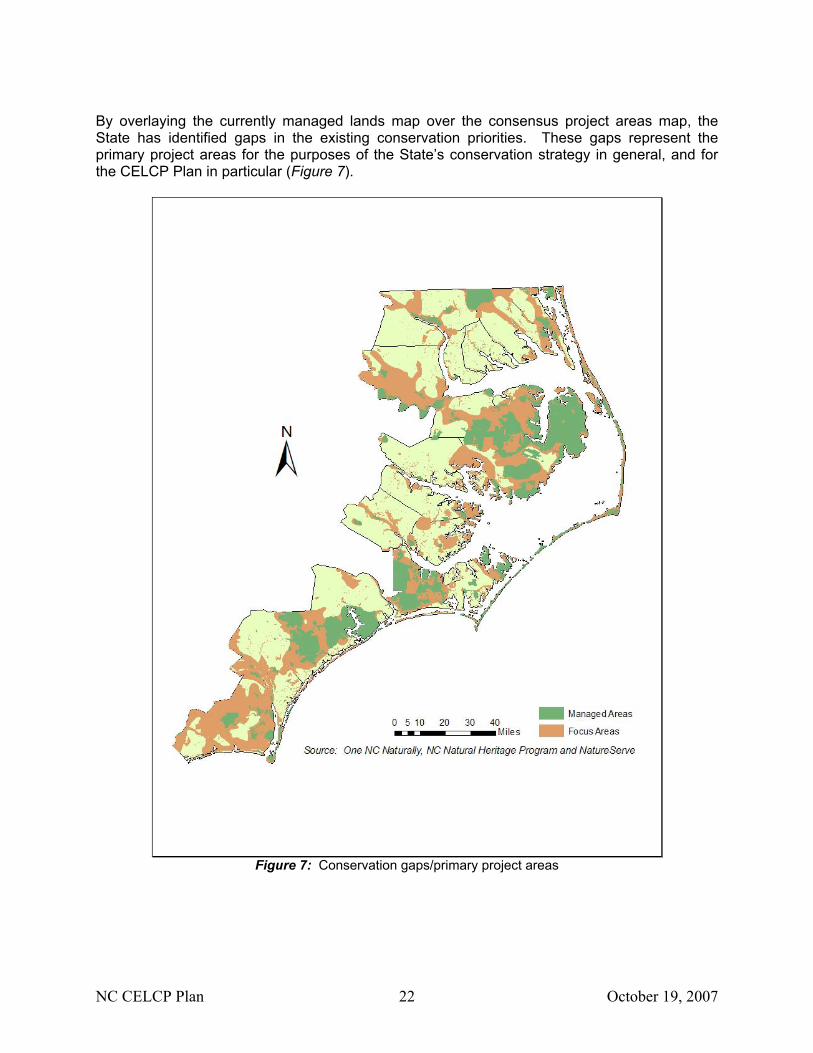
By overlaying the currently managed lands map over the consensus project areas map, the State has identified gaps in the existing conservation priorities. These gaps represent the primary project areas for the purposes of the State’s conservation strategy in general, and for the CELCP Plan in particular (Figure 7).
Figure 7: Conservation gaps/primary project areas
NC CELCP Plan 23 October 19, 2007
All of the priority project areas that have been identified are consistent with the national criteria for project areas. All these areas possess high conservation values and suffer from high conversion rates, all areas can be effectively managed (either actively or passively), all areas directly advance the goals and implementation of the State’s coastal management program and NERR management plan, and all areas are consistent with the State’s approved coastal management program.
NC CELCP Plan 24 October 19, 2007
D. Description of Existing Plans North Carolina’s CELCP plan is largely based on the conservation planning efforts by (1) the State’s “One North Carolina Naturally” initiative; (2) the Nature Conservancy; and (3) the regional partnerships developing throughout the coastal zone. These plans have based their conservation targets heavily on the Significant Natural Heritage Areas (SNHAs) defined by the NC Natural Heritage Program. Protection of these rare and/or high quality habitats through CELCP funding can further the goals and objectives of federal, state, regional, and local conservation planning efforts. The NC CELCP plan builds upon existing conservation efforts, rather than duplicating them. Project area selection is supported by several conservation efforts already underway within North Carolina. DCM drew upon the following programs and plans to help identify lands, values and project areas of highest importance to the State. The existing plans and planning activities are not static. Most plans are regularly updated, and planning efforts are periodically revisited and adapted to reflect new and anticipated conditions. New regional conservation planning collaborations are taking shape through the process of identifying acquisition priorities, redefining project boundaries and leveraging the resources of participating groups. The twenty CAMA counties and various coastal municipalities address land conservation priorities through their local land use plans. These plans may further address conservation status and trends, and conversion threats to specific tracts that have been defined as Project Areas in North Carolina’s CELCP plan. Although these plans are not included here, the use of these local plans as supporting documentation for potential projects is encouraged. Summary of Existing Plans I. State and State-Federal Government Programs & Plans
NC Division of Coastal Management & NC Coastal Reserves: - NCNERR Reserve Management Plan
NC Office of Conservation & Community Affairs: - One NC Naturally - Natural Heritage Program Biennial Protection Plan
NC Division of Parks & Recreation: - New Parks for a New Century - Mountains to Sea Trail
NC Department of Environment & Natural Resources: - Coastal Habitat Protection Plan
NC Wildlife Resources Commission: - Wildlife Action Plan
II. Non-Profit & Public-Private Partnership Plans
The Nature Conservancy: - Mid-Atlantic Coastal Plain Ecoregional Plan
NC Coastal Federation: - Oyster Restoration & Protection Plan for NC
Onslow Bight Conservation Forum: - Onslow Bight Conservation Design Plan
NC Coastal Land Trust: - Riparian Corridor Conservation Plans
NC CELCP Plan 25 October 19, 2007
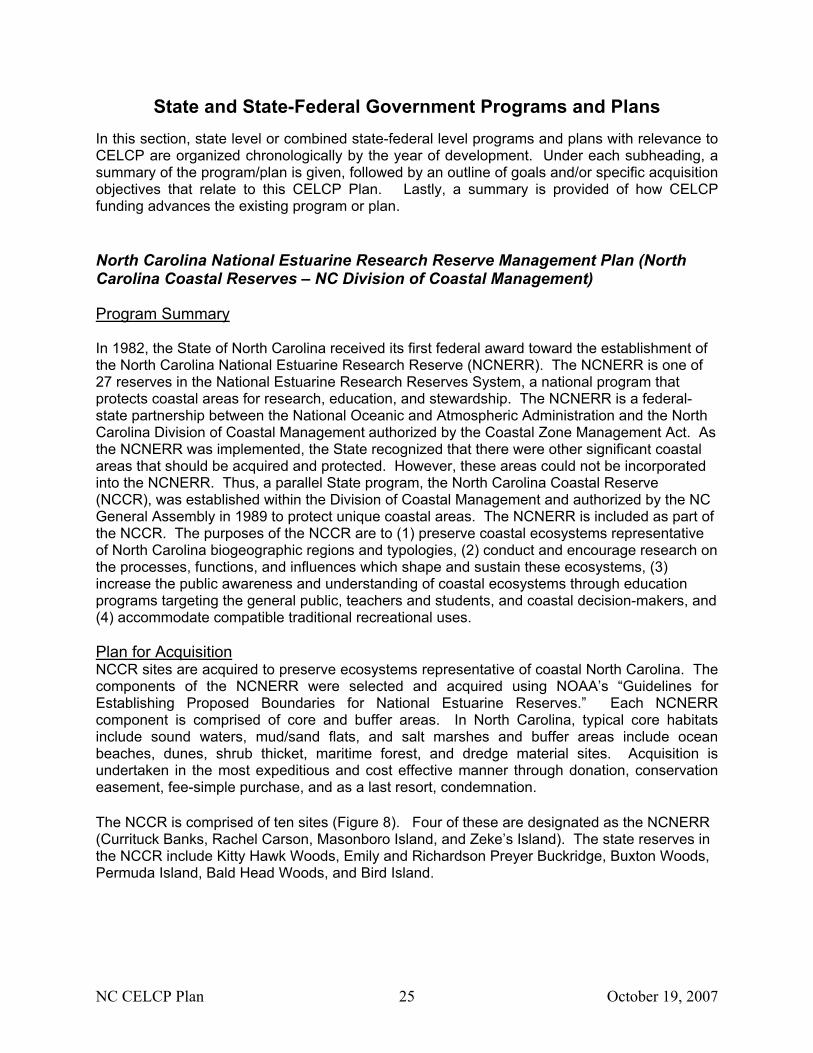
State and State-Federal Government Programs and Plans In this section, state level or combined state-federal level programs and plans with relevance to CELCP are organized chronologically by the year of development. Under each subheading, a summary of the program/plan is given, followed by an outline of goals and/or specific acquisition objectives that relate to this CELCP Plan. Lastly, a summary is provided of how CELCP funding advances the existing program or plan. North Carolina National Estuarine Research Reserve Management Plan (North Carolina Coastal Reserves – NC Division of Coastal Management) Program Summary In 1982, the State of North Carolina received its first federal award toward the establishment of the North Carolina National Estuarine Research Reserve (NCNERR). The NCNERR is one of 27 reserves in the National Estuarine Research Reserves System, a national program that protects coastal areas for research, education, and stewardship. The NCNERR is a federal-state partnership between the National Oceanic and Atmospheric Administration and the North Carolina Division of Coastal Management authorized by the Coastal Zone Management Act. As the NCNERR was implemented, the State recognized that there were other significant coastal areas that should be acquired and protected. However, these areas could not be incorporated into the NCNERR. Thus, a parallel State program, the North Carolina Coastal Reserve (NCCR), was established within the Division of Coastal Management and authorized by the NC General Assembly in 1989 to protect unique coastal areas. The NCNERR is included as part of the NCCR. The purposes of the NCCR are to (1) preserve coastal ecosystems representative of North Carolina biogeographic regions and typologies, (2) conduct and encourage research on the processes, functions, and influences which shape and sustain these ecosystems, (3) increase the public awareness and understanding of coastal ecosystems through education programs targeting the general public, teachers and students, and coastal decision-makers, and (4) accommodate compatible traditional recreational uses. Plan for Acquisition NCCR sites are acquired to preserve ecosystems representative of coastal North Carolina. The components of the NCNERR were selected and acquired using NOAA’s “Guidelines for Establishing Proposed Boundaries for National Estuarine Reserves.” Each NCNERR component is comprised of core and buffer areas. In North Carolina, typical core habitats include sound waters, mud/sand flats, and salt marshes and buffer areas include ocean beaches, dunes, shrub thicket, maritime forest, and dredge material sites. Acquisition is undertaken in the most expeditious and cost effective manner through donation, conservation easement, fee-simple purchase, and as a last resort, condemnation. The NCCR is comprised of ten sites (Figure 8). Four of these are designated as the NCNERR (Currituck Banks, Rachel Carson, Masonboro Island, and Zeke’s Island). The state reserves in the NCCR include Kitty Hawk Woods, Emily and Richardson Preyer Buckridge, Buxton Woods, Permuda Island, Bald Head Woods, and Bird Island.
NC CELCP Plan 26 October 19, 2007
Figure 8: North Carolina Coastal Reserve (NCCR)
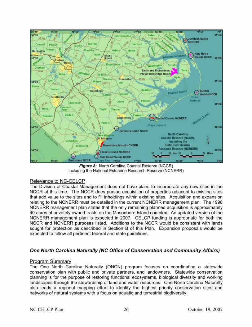
including the National Estuarine Research Reserve (NCNERR) Relevance to NC-CELCP The Division of Coastal Management does not have plans to incorporate any new sites in the NCCR at this time. The NCCR does pursue acquisition of properties adjacent to existing sites that add value to the sites and to fill inholdings within existing sites. Acquisition and expansion relating to the NCNERR must be detailed in the current NCNERR management plan. The 1998 NCNERR management plan states that the only remaining planned acquisition is approximately 40 acres of privately owned tracts on the Masonboro Island complex. An updated version of the NCNERR management plan is expected in 2007. CELCP funding is appropriate for both the NCCR and NCNERR purposes listed. Additions to the NCCR would be consistent with lands sought for protection as described in Section B of this Plan. Expansion proposals would be expected to follow all pertinent federal and state guidelines. One North Carolina Naturally (NC Office of Conservation and Community Affairs) Program Summary The One North Carolina Naturally (ONCN) program focuses on coordinating a statewide conservation plan with public and private partners, and landowners. Statewide conservation planning is for the purpose of restoring functional ecosystems, biological diversity and working landscapes through the stewardship of land and water resources. One North Carolina Naturally also leads a regional mapping effort to identify the highest priority conservation sites and networks of natural systems with a focus on aquatic and terrestrial biodiversity.
NC CELCP Plan 27 October 19, 2007
In 2002, One North Carolina Naturally divided the state into eight regions to examine conservation planning at manageable scales and to facilitate communication and meeting among individuals. The North Coastal Plain and South Coastal Plain encompass the CELCP funding jurisdiction and extend to coastal plain counties further inland. Public meetings were held by Regional Councils of Government to offer interested persons an opportunity to express their opinions on specific conservation needs and priorities. The outcome was a list and map of potential conservation targets and open space conservation strategies for each region. Plan for Acquisition The Mid-East Commission worked with Beaufort, Bertie, Hertford, Martin and Pitt counties to develop a coordinated open space conservation strategy. Farming and forestry dominate the landscape in this very rural area. Significant land areas are already conserved in gamelands, state parks, and riparian areas along the Roanoke River. Additional open space being considered includes multiple use areas such as habitat corridors, trails and greenways. County maps of property that has been conserved or in which there is interest in conserving will continue to be refined. The Albemarle Commission developed an Open Space Plan for 10 CAMA counties in the northeast corner of the state (Camden, Chowan, Currituck, Dare, Gates, Hyde, Pasquotank, Perquimans, Tyrrell and Washington counties). Both ends of the economic spectrum are represented in this region, with Dare experiencing a tourism-fueled influx of new residents and most other counties sparsely populated. Much of the area is dependent on agriculture and commercial fishing and conservation programs to protect these economies are vital. Large portions of this region are already in state and federal land conservation programs, but lands acquired to serve as greenways could provide connectivity between refuges and encourage ecotourism. The Cape Fear Council of Governments developed an open space strategy and map for Brunswick, Columbus, New Hanover and Pender counties in the Southern Coastal Plain. Streams adjacent to coastal areas are under pressure from increasing development and recreational use, so maintaining water quality is a priority. Some environmentally sensitive areas are already conserved as open space and used for parks, gamelands and reserves, but additional areas could be included. Agriculture and timberlands can be preserved and kept economically viable through easements and tax incentives. The Eastern Carolina Council completed an open space plan for Carteret, Craven, Duplin, Greene, Jones, Lenoir, Onslow, Pamlico and Wayne counties in the Southern Coastal Plain. Land use in these counties ranges from largely agricultural rural areas where open space is taken for granted to rapidly developing coastal communities that appeal to tourists and retirees. Further open space planning will address encroachment around military installations, high growth coastal areas, water quality, and preserving the region’s natural environment. Relevance to NC-CELCP The outcome of these regional Councils of Government planning efforts were a series of maps identifying potential management sites. These maps were combined to give the comprehensive map shown in Section C – Figure 5. Local governments can use CELCP funding to acquire lands meeting the objectives codified in their regional Open Space Plans. Overall, conservation of habitat corridors, greenways, and lands adjacent to existing managed lands are of highest priority. Conservation of lands that protect water quality and agricultural lands are also of great importance, consistent with NC-CELCP priorities outlined in Section B.
NC CELCP Plan 28 October 19, 2007
New Parks For a New Century (NC Division of Parks and Recreation) Program Summary The NC Division of Parks and Recreation (DPR) started a process in 2002 to identify sites within the state as potential additions to the State parks system. The initiative, called New Parks for a New Century, currently lists 13 targets within the CELCP planning area, including two potential state parks and eleven potential state natural areas.
State parks are expected to possess significant natural resource values and to provide high quality recreational opportunities. State Parks are expected to offer developed facilities, but the extent of that development may vary depending on what can be provided without damage to the scenic or natural features. The establishment of any new state park would include the expectation that the park would eventually be open to the public with some level of facilities provided.
State natural areas, are intended to preserve and protect areas of scientific, aesthetic or ecological value. Long-term management objectives for a natural area may include no or few public facilities and restricted access. Generally, recreational activities such as camping, swimming or picnicking are not allowed, though some natural areas offer trails and interpretive programming.
Plan for Acquisition The NC Division of Parks and Recreation’s philosophy is that new units added to the state parks system should focus on sites of statewide significance, on ensuring that representative examples of the State's resources are protected and on providing state park services to areas of the state currently underserved. The NC State Parks Act directs the system to include representative samples of the State’s archaeological, geological, biological, scenic, and recreational resources. Within these categories the DPR has identified 108 resource themes (e.g. tidal wetlands, spruce-fir forests, etc.), only 29 of which are regarded as being adequately represented within the parks system. The DPR’s acquisition strategy seeks not only to acquire more themes, but also to keep pace with the forecast increased demand for public use. The DPR uses site selection criteria and a scoring system to evaluate potential additions, but applies additional professional judgment before making its final decisions. Using the additional judgment makes it impractical for the DPR to prioritize among the sites that it has already identified as potential additions.
NC CELCP Plan 29 October 19, 2007
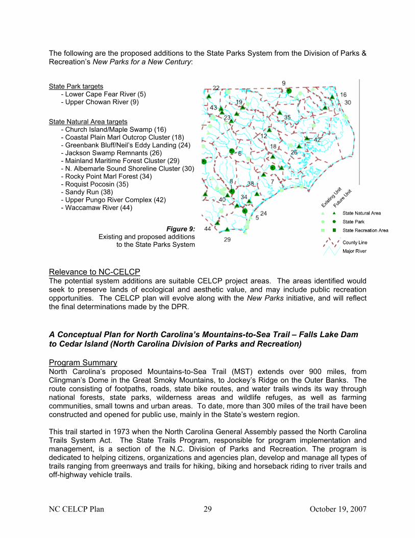
The following are the proposed additions to the State Parks System from the Division of Parks & Recreation’s New Parks for a New Century: State Park targets
- Lower Cape Fear River (5) - Upper Chowan River (9)
State Natural Area targets
- Church Island/Maple Swamp (16) - Coastal Plain Marl Outcrop Cluster (18) - Greenbank Bluff/Neil’s Eddy Landing (24) - Jackson Swamp Remnants (26) - Mainland Maritime Forest Cluster (29) - N. Albemarle Sound Shoreline Cluster (30) - Rocky Point Marl Forest (34) - Roquist Pocosin (35) - Sandy Run (38) - Upper Pungo River Complex (42) - Waccamaw River (44)
Figure 9:
Existing and proposed additions to the State Parks System
Relevance to NC-CELCP The potential system additions are suitable CELCP project areas. The areas identified would seek to preserve lands of ecological and aesthetic value, and may include public recreation opportunities. The CELCP plan will evolve along with the New Parks initiative, and will reflect the final determinations made by the DPR. A Conceptual Plan for North Carolina’s Mountains-to-Sea Trail – Falls Lake Dam to Cedar Island (North Carolina Division of Parks and Recreation) Program Summary North Carolina’s proposed Mountains-to-Sea Trail (MST) extends over 900 miles, from Clingman’s Dome in the Great Smoky Mountains, to Jockey’s Ridge on the Outer Banks. The route consisting of footpaths, roads, state bike routes, and water trails winds its way through national forests, state parks, wilderness areas and wildlife refuges, as well as farming communities, small towns and urban areas. To date, more than 300 miles of the trail have been constructed and opened for public use, mainly in the State’s western region. This trail started in 1973 when the North Carolina General Assembly passed the North Carolina Trails System Act. The State Trails Program, responsible for program implementation and management, is a section of the N.C. Division of Parks and Recreation. The program is dedicated to helping citizens, organizations and agencies plan, develop and manage all types of trails ranging from greenways and trails for hiking, biking and horseback riding to river trails and off-highway vehicle trails.
NC CELCP Plan 30 October 19, 2007
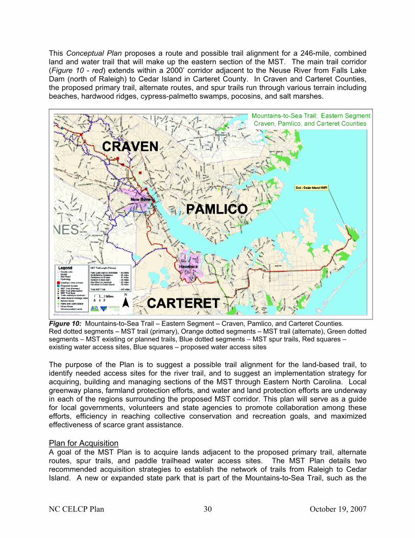
This Conceptual Plan proposes a route and possible trail alignment for a 246-mile, combined land and water trail that will make up the eastern section of the MST. The main trail corridor (Figure 10 - red) extends within a 2000’ corridor adjacent to the Neuse River from Falls Lake Dam (north of Raleigh) to Cedar Island in Carteret County. In Craven and Carteret Counties, the proposed primary trail, alternate routes, and spur trails run through various terrain including beaches, hardwood ridges, cypress-palmetto swamps, pocosins, and salt marshes.
Figure 10: Mountains-to-Sea Trail – Eastern Segment – Craven, Pamlico, and Carteret Counties. Red dotted segments – MST trail (primary), Orange dotted segments – MST trail (alternate), Green dotted segments – MST existing or planned trails, Blue dotted segments – MST spur trails, Red squares – existing water access sites, Blue squares – proposed water access sites The purpose of the Plan is to suggest a possible trail alignment for the land-based trail, to identify needed access sites for the river trail, and to suggest an implementation strategy for acquiring, building and managing sections of the MST through Eastern North Carolina. Local greenway plans, farmland protection efforts, and water and land protection efforts are underway in each of the regions surrounding the proposed MST corridor. This plan will serve as a guide for local governments, volunteers and state agencies to promote collaboration among these efforts, efficiency in reaching collective conservation and recreation goals, and maximized effectiveness of scarce grant assistance. Plan for Acquisition A goal of the MST Plan is to acquire lands adjacent to the proposed primary trail, alternate routes, spur trails, and paddle trailhead water access sites. The MST Plan details two recommended acquisition strategies to establish the network of trails from Raleigh to Cedar Island. A new or expanded state park that is part of the Mountains-to-Sea Trail, such as the
NC CELCP Plan 31 October 19, 2007
proposed Middle Neuse River State Park in Southeast Johnston County and Wayne County, can provide many benefits to the residents and to the economy of eastern North Carolina. This addition to the state parks system would also enhance the New Parks for a New Century program. Local governments are encouraged to work with land trusts and the State of North Carolina to complete the acquisition of the needed land rights to facilitate unpaved and paved land-based trails, and access areas for paddle trailheads. The State should work with local governments and make additional investments in land acquisition along the corridor in cases where the local level partners are unable to meet the responsibilities laid out for them in the MST Plan. In addition, private sector groups and individuals are encouraged to assist local governments and state agencies with acquisition of the priority lands defined within the Plan. It has taken more than two decades to assemble and open for public use the 300+ miles of the MST corridor in western North Carolina. There is a strong desire and spirit of cooperation emerging to move to rapidly expand the trail in eastern North Carolina. When completed, the Mountains-To-Sea Trail will enable North Carolinians to walk, bike, or paddle, without interruption, from one of the end of the state to the other. Relevance to NC-CELCP The MST Conceptual Plan calls for the cooperation of state and local governments, and private sector interests to acquire and manage lands along the MST. Both state and local governments can utilize CELCP funding to acquire sections of the proposed trail that may be under threat of conversion to other uses and create/expand the state parks system through which the trail passes. The proposed trail network in Craven and Carteret Counties pass through Neuse River floodplains, wetlands, marshes, beaches, and other ecologically significant habitats. CELCP funding for the MST provides ecological, recreational, aesthetic and general conservation benefits, all which are consistent with the priorities of the national and State CELC Programs. North Carolina Coastal Habitat Protection Plan (NC Department of Environment and Natural Resources) Program Summary The Coastal Habitat Protection Plan (CHPP) was developed to coordinate coastal habitat protection efforts throughout the State. In 1997, the N.C. General Assembly passed the Fisheries Reform Act requiring three of the State’s regulatory commissions (Marine Fisheries, Environmental Management, and Coastal Resources), to adopt an inter-agency plan to protect and restore resources critical to North Carolina’s commercial and recreational fisheries. The CHPP was developed through a cooperative, multi-agency effort with public input. The final draft was presented to the three regulatory commissions in September 2004 and they adopted joint implementation of the plan in June and July of 2005. The CHPP outlines opportunities to be proactive about protecting and restoring the habitats important to North Carolina’s fisheries and economy. The CHPP examines six critical marine habitats in 11 geographic regions that closely follow coastal watershed boundaries. The document defines these habitats as the water column, shell bottom, submerged aquatic vegetation, wetlands, soft bottom, and hard bottom. It uses scientific information to describe the habitats ecological function and importance to marine fisheries. The CHPP identifies threats to and management needs for each habitat, and recommends research, regulatory, and non-
NC CELCP Plan 32 October 19, 2007
regulatory steps needed to protect, restore, and enhance each habitat. Stormwater runoff presents the greatest single threat to North Carolina’s coastal fish habitats. Pressures from development, loss of habitat, pollution and degraded water quality threaten North Carolina’s economy, way of life, and the character of the coastal region. In 1998, the Marine Fisheries Commission identified a need to designate Strategic Habitat Areas (SHAs). These areas are complexes of fisheries habitat that “provide exceptional functions that are particularly at risk due to imminent threats, vulnerability or rarity.” These areas merit special attention and should be given high priority for conservation. SHAs may include areas previously defined by other state or federal agencies (AECs, HAPCs, ORWs, PNAs, for example), or others as deemed necessary in the approved CHPP. Designation of SHAs will be developed based on existing DMF procedures for identifying Primary Nursery Areas, effects of land use and human activities on those habitats, fish populations and other natural resources in specific habitat areas, potential threats in or near those habitat areas, and an assessment of linkages between habitats and fisheries resources. Once areas are designated as SHAs, existing rules and voluntary initiatives pertinent to that area should be compared to potential threats in order to identify any gaps in protecting its current strategic functions. This evaluation could lead to new rules to protect the area, or modifications of existing management activities (enforcement, education, land acquisition). Plan for Acquisition The following examples of implementation actions related to CELCP are organized according to the CHPP’s four habitat protection goals: • Goal 1: Improve effectiveness of existing rules and programs protecting coastal fish
habitats • Goal 2: Identify, designate and protect strategic habitat areas (SHAs)
SHAs are to be identified and designated using ecologically based criteria. Other implementation actions include analyzing existing rules and enacting measures needed to protect SHAs, and improving programs for conservation (including voluntary actions) and acquisition of areas supporting SHAs.
• Goal 3: Enhance habitat and protect it from physical impacts NC DENR review of state agency requests to the Natural Heritage Trust Fund will place a priority on those proposals that would further the protection and restoration of critical fisheries habitats. Protection and restoration of critical habitats are to be made a priority part of the One North Carolina Naturally initiative, such as the development of conservation plans for the 20 coastal counties that will identify potential conservation focus areas. Funding is sought for the potential acquisition of these areas.
• Goal 4: Enhance and protect water quality Implementation actions include improving land-based strategies to reduce non-point source pollution and minimize cumulative losses to wetlands and streams. Larger vegetated buffers, more stringent impervious surface limits, expansion of Areas of Environmental Concern upstream and landward, and setbacks along estuarine shorelines help to achieve this goal.
Relevance to NC-CELCP Clean and healthy waters are critical to the overall viability of coastal fish habitats and the associated aquatic organisms. Efforts are needed to minimize pollution threats and enhance water quality through protection and restoration of natural lands along waterways. CELCP will
NC CELCP Plan 33 October 19, 2007
advance the efforts of the CHPP through protection of lands adjacent to coastal fish habitats designated as SHAs. CELCP can serve as match to projects funded by State’s trust funds, such as Clean Water Management Trust Fund, for the protection and restoration of critical fisheries habitat and coastal areas adjacent to these habitats. CELCP funding can also advance the goal of water quality protection through preservation of wetlands and naturally vegetated buffers along waterways. North Carolina Wildlife Action Plan (NC Wildlife Resources Commission) Program Summary The NC Wildlife Resources Commission (WRC) developed the Wildlife Action Plan in 2005 to serve as a wildlife conservation blueprint for the State. Beginning in 2001, the U.S. Congress provided annual appropriations to States to supplement existing fish and wildlife conservation resources. Funding has been provided under the Wildlife Conservation and Restoration Program and the State Wildlife Grants Program. Congress required recipient states to prepare comprehensive plans for conserving wildlife and their associated habitats. The WRC developed the plan over a period of approximately three years, engaging hundreds of stakeholders drawn from federal and state agencies, the non-governmental community, the academic community, and the private sector. Plans had to be completed by October 2005, with reviews and revisions to occur at least every ten years. The plan identifies critical fish and wildlife resources and the priority conservation needs associated with those resources. The Action Plan includes five core goals:
1. Improve the understanding of species diversity in NC and enhance our ability to make conservation or management decisions for all species
2. Conserve and enhance habitats and the communities they support 3. Foster partnerships and cooperative efforts among natural resource agencies,
organizations, academia, and private industry 4. Support educational efforts to improve understanding of wildlife resources among the
general public and conservation stakeholders 5. Support and improve existing regulations and programs aimed at conserving habitats
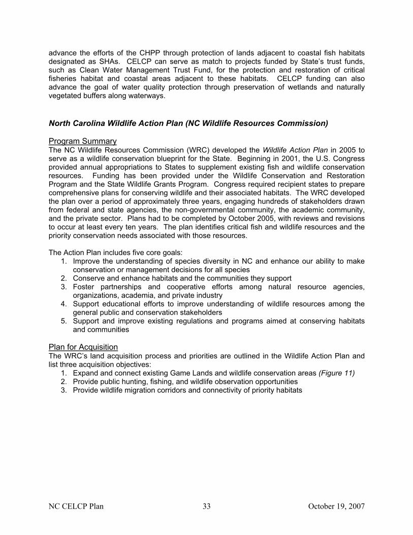
and communities Plan for Acquisition The WRC’s land acquisition process and priorities are outlined in the Wildlife Action Plan and list three acquisition objectives:
1. Expand and connect existing Game Lands and wildlife conservation areas (Figure 11) 2. Provide public hunting, fishing, and wildlife observation opportunities 3. Provide wildlife migration corridors and connectivity of priority habitats
NC CELCP Plan 34 October 19, 2007
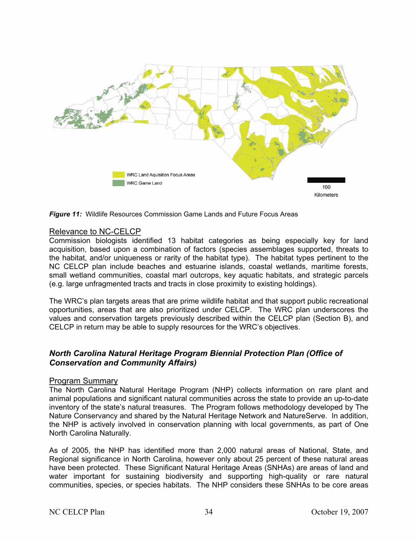
Figure 11: Wildlife Resources Commission Game Lands and Future Focus Areas Relevance to NC-CELCP Commission biologists identified 13 habitat categories as being especially key for land acquisition, based upon a combination of factors (species assemblages supported, threats to the habitat, and/or uniqueness or rarity of the habitat type). The habitat types pertinent to the NC CELCP plan include beaches and estuarine islands, coastal wetlands, maritime forests, small wetland communities, coastal marl outcrops, key aquatic habitats, and strategic parcels (e.g. large unfragmented tracts and tracts in close proximity to existing holdings). The WRC’s plan targets areas that are prime wildlife habitat and that support public recreational opportunities, areas that are also prioritized under CELCP. The WRC plan underscores the values and conservation targets previously described within the CELCP plan (Section B), and CELCP in return may be able to supply resources for the WRC’s objectives. North Carolina Natural Heritage Program Biennial Protection Plan (Office of Conservation and Community Affairs) Program Summary The North Carolina Natural Heritage Program (NHP) collects information on rare plant and animal populations and significant natural communities across the state to provide an up-to-date inventory of the state’s natural treasures. The Program follows methodology developed by The Nature Conservancy and shared by the Natural Heritage Network and NatureServe. In addition, the NHP is actively involved in conservation planning with local governments, as part of One North Carolina Naturally. As of 2005, the NHP has identified more than 2,000 natural areas of National, State, and Regional significance in North Carolina, however only about 25 percent of these natural areas have been protected. These Significant Natural Heritage Areas (SNHAs) are areas of land and water important for sustaining biodiversity and supporting high-quality or rare natural communities, species, or species habitats. The NHP considers these SNHAs to be core areas
NC CELCP Plan 35 October 19, 2007
for conservation. The NC NHP has also designed macrosites, which contain one or more SNHAs and intervening habitats that typically serve as buffers, wildlife corridors, or other connectors with enough integrity to support ecosystem function. Plan for Acquisition The Biennial Protection Plan provides a complete list of natural areas in North Carolina identified by the NHP as being of National, State, Regional, or Local significance. The list is arranged alphabetically by county, and natural areas are listed in descending order of priority within a county. Where appropriate, sites are grouped by megasite and macrosite. The list also provides the USGS quad maps, significance rating, general ownership, and protection comments for each natural area. The NHP does not outline objectives or strategies for acquisition of these areas, but it serves as a comprehensive list of sites to facilitate the establishment of conservation priorities within many of the State’s acquisition programs. Relevance to NC-CELCP CELCP conservation priorities are consistent with the Natural Heritage Program’s priority of protecting State areas with high biodiversity and rare natural communities. Although SNHAs and macrosites defined through the NHP consist of large polygons of significant conservation areas, individual occurrences of natural communities can be used by CELCP applicants to locate finer-scale sites of significance.
NC CELCP Plan 36 October 19, 2007
Conservation Non-Profit Organization & Public-Private Partnership Programs and Plans
In this section, conservation non-profit programs and plans with relevance to CELCP are organized chronologically by the year of development. Under each subheading, a summary of the program/plan is given, followed by an outline of goals and/or specific acquisition objectives that relate to this CELCP Plan. Lastly, a summary is provided of how CELCP funding advances the existing program or plan. Mid-Atlantic Coastal Plain Ecoregional Plan (The Nature Conservancy, North Carolina Chapter) Program Summary The Nature Conservancy (TNC) works to protect biological diversity and functional landscapes through land conservation. Their efforts to set ecoregional conservation priorities represent directed work toward this end. Between 1996 and 1999, representatives from TNC chapter and regional offices, and State Natural Heritage Programs developed a planning team to develop the Mid-Atlantic Coastal Plain Ecoregional Plan. The Mid-Atlantic Coastal Plain (MACP) occupies 26 million acres east of the fall line between the Piedmont and Atlantic Coastal Plain, south of the James River in Virginia and north of Charleston Harbor in South Carolina. About two thirds of this very rich ecoregion is in North Carolina. The goal of ecoregional planning is to identify regionally significant conservation target areas and networks that contain representative examples of the region’s rare or threatened species and diverse natural communities and ecosystems whose conservation will ensure long-term biodiversity. The MACP is incredibly diverse. Ecoregional planning is driven by Natural Heritage Program data and other ecological data from expert feedback. Global rankings, G1 and G2, species and natural community elements as defined by the NHP were selected as conservation targets. The ecoregional planning team working on this region established goals for 561 targets (97 animal species, 224 plant species, 240 plant community types). Plan for Acquisition Crude polygons that enveloped these conservation targets and significant natural heritage areas were drawn, taking into account where protection strategies might cohere. Ninety portfolio sites were selected for immediate conservation planning and implementation. 28 additional, small, typically isolated sites were identified for future verification. Many action sites currently exist within the CELCP planning region, such as the Onslow Bight, Waccamaw River, Southeastern Brunswick County, Roanoke River, and Alligator River/Scuppernong River/Pocosin Lakes, where substantial conservation actions are taking place. Landscape management plans that identify threats and stressors to these areas have been developed. These plans outline a process for identifying priorities within these action sites, including acquisitions. The Mid-Atlantic Coastal Plain Ecoregional Plan does not include specific acquisition objectives or actions. These are specific to the action site and can be found within the landscape management plans. Relevance to NC-CELCP The data used to develop these conservation sites are recognized as far from perfect since new information becomes available all the time. Selection and design of these sites are permanently
NC CELCP Plan 37 October 19, 2007
on-going and incremental processes. These sites provide CELCP with priority focus areas, but applicants looking to receive funding should convey a specific site’s local significance and relevance to the landscape management plan. Oyster Restoration and Protection Plan For North Carolina: A Blueprint For Action (North Carolina Coastal Federation) Program Summary The Oyster Restoration and Protection Plan is a bold effort to bring together and coordinate the activities and resources of private and public efforts to bring back oysters in NC. The State’s population of Eastern Oysters (Crassostrea virginica) has declined by an estimated 90% since the early 1900’s due to habitat loss, pollution, diseases, and harvest pressure. In 2003, the North Carolina Coastal Federation (NCCF) invited scientists, fishermen, policymakers, and educators to the Oyster Forum. There was broad agreement that a number of actions needed to be taken over the next three to five years to protect and restore native oysters in North Carolina. A range of goals, objectives, and specific actions were drafted into the five-year Blueprint. The Blueprint’s overarching goals are to: • Restore and protect North Carolina’s native oyster populations, and habitat so that estuaries
are again robust, diverse, and resilient ecosystems. • Build broad public awareness and support for the value of estuarine conservation and
sustainable fisheries. • Work with a strong coalition to make significant, demonstrable and meaningful progress
towards oyster restoration in the next three to five years. Objective and actions include: • Organization and maintenance of a steering committee to oversee the implementation of the
Plan, and organization of regional workgroups to implement the plan. • Biannual oyster summits to review progress and conduct collaborative strategic planning. • Protection and restoration of water quality near areas designated as oyster habitat. • Development and implementation of research programs to assess the success of restoration
efforts. • Increasing public awareness of the importance of healthy oyster populations and expanding
citizen support in the protection and restoration of oyster habitat. • Developing and marketing a sustainable native oyster fishery, including the promotion of
oyster mariculture. • Linking and coordinating the Plan with ongoing planning efforts such as the Coastal Habitat
Protection Plan and Ecosystem Enhancement Program. • Development of a long-term protection and restoration plan to be integrated into the 2006
revision of the NC Division of Marine Fisheries Oyster Fishery Management Plan • Securing of funds for restoration, research, and protection of shellfishing waters. • Improvement of water quality rules and enforcement. Plan for Acquisition The Blueprint identifies land acquisition as critical to carrying out some of the objectives within this comprehensive Oyster Restoration and Protection Plan. A working group was created to
NC CELCP Plan 38 October 19, 2007
identify, prioritize, and pursue land acquisitions and conservation easements. These measures are important for preserving pristine and threatened watersheds adjacent to productive shellfish growing areas (Action 5.2.3, Action 7.3.3). Planning grants are targeted in order to develop measurable objectives for oyster habitat restoration or creation and watershed protection for identified priority growing areas in each of the northern, central, and southern regions, resulting in at least one acquisition per region (Action 2.1.1). As maps of prime oyster habitat are developed, they will be used to prioritize surrounding lands important to preserving habitat quality and ecosystem function. Relevance to NC-CELCP The Blueprint identifies many objectives and actions that are consistent with other planning efforts, such as the Coastal Habitat Protection Plan (CHPP), which also includes acquisition priorities for the protection of water quality in areas suitable for oyster habitat. Lands adjacent to these waters, which may be designated as HQWs or SHAs, are considered high priorities for NC-CELCP (Section B). CELCP funding also recognizes projects that meet multiple objectives through collaborative efforts. Onslow Bight Conservation Design Plan (Onslow Bight Conservation Forum) Program Summary The Onslow Bight Conservation Forum was established through a Memorandum of Understanding between twelve agencies and organizations for the purpose of enhancing cooperation and communication regarding regional conservation issues within the Onslow Bight landscape (Figure 12). The need for this collaborative forum and conservation plan is in response to rapid development within the landscape that threatens to destroy or fragment critical natural habitat. The landscape is biologically and ecologically diverse with numerous rare species, several which are entirely or largely endemic to the region. The Plan, as the product of a “Reserve Design” subcommittee’s efforts since 2002, defines conservation targets, sets forth conservation priorities within the landscape, and presents acquisition/protection strategies as well as management and action strategies. Conservation targets are defined as “specific features of biodiversity” that contain species, community, and ecosystem level rare or vulnerable elements. These high priority targets include longleaf pine and pocosin ecosystems, barrier and estuarine islands, non-riverine wet hardwood and swamp forests, coastal fringe forests, coastal plain marl outcrops, small depression wetlands and natural lake shorelines, blackwater and brownwater floodplains, mesic and dry hardwood forests, special animal habitats, non-tidal and tidal freshwater aquatic habitats, estuarine marshes, and marine aquatic habitats. Conservation strategies are condensed into the following prioritized list:
1. Increase protection of lands of highest value to conservation targets 2. Use appropriate management to sustain conservation targets, maintain corridor function,
and promote ecological processes 3. Reduce habitat fragmentation by increasing the area of target habitats, and connecting
larger blocks of habitat 4. Increase outreach and coordination among Forum partners and with local communities
NC CELCP Plan 39 October 19, 2007
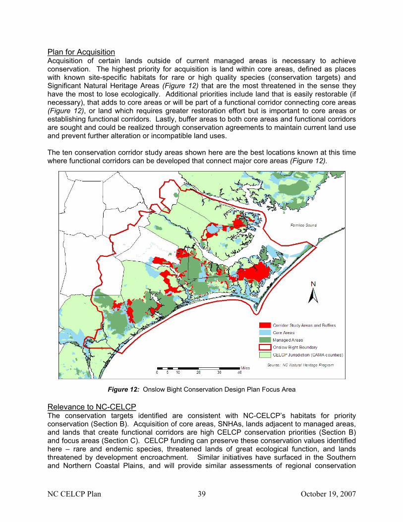
Plan for Acquisition Acquisition of certain lands outside of current managed areas is necessary to achieve conservation. The highest priority for acquisition is land within core areas, defined as places with known site-specific habitats for rare or high quality species (conservation targets) and Significant Natural Heritage Areas (Figure 12) that are the most threatened in the sense they have the most to lose ecologically. Additional priorities include land that is easily restorable (if necessary), that adds to core areas or will be part of a functional corridor connecting core areas (Figure 12), or land which requires greater restoration effort but is important to core areas or establishing functional corridors. Lastly, buffer areas to both core areas and functional corridors are sought and could be realized through conservation agreements to maintain current land use and prevent further alteration or incompatible land uses. The ten conservation corridor study areas shown here are the best locations known at this time where functional corridors can be developed that connect major core areas (Figure 12).
Figure 12: Onslow Bight Conservation Design Plan Focus Area
Relevance to NC-CELCP The conservation targets identified are consistent with NC-CELCP’s habitats for priority conservation (Section B). Acquisition of core areas, SNHAs, lands adjacent to managed areas, and lands that create functional corridors are high CELCP conservation priorities (Section B) and focus areas (Section C). CELCP funding can preserve these conservation values identified here – rare and endemic species, threatened lands of great ecological function, and lands threatened by development encroachment. Similar initiatives have surfaced in the Southern and Northern Coastal Plains, and will provide similar assessments of regional conservation
NC CELCP Plan 40 October 19, 2007
priorities and strategies. These collaborative initiatives will benefit from CELCP funding opportunities to preserve some of the last remaining ecologically significant lands. Riparian Corridor Conservation Plans (NC Coastal Land Trust) Program Summary The North Carolina Coastal Land Trust (NCCLT) enriches the coastal communities of North Carolina through the acquisition of open space and natural areas, conservation education, and the promotion of sound land stewardship. The NCCLT is committed to protecting riparian corridors throughout the coastal plain of North Carolina for the purpose of enhancing water quality; conserving significant natural areas, improving wildlife habitat; and increasing recreational opportunities. Plan for Acquisition With funding assistance from the State Clean Water Management Trust Fund through the Conservation Trust for North Carolina, the NCCLT has identified several priority river reaches in the coastal plain and has developed riparian corridor conservation plans for these specific focus areas. The primary purpose of the riparian corridor plans is to analyze and prioritize specific parcels of land along these select river reaches for possible future conservation. The NCCLT developed parcel prioritization strategies with an emphasis on water quality and natural heritage values for the focus areas identified below. The NCCLT continues to work with landowners of priority parcels to achieve conservation objectives along these river corridors. Plan Focus Areas:
• Waccamaw River (Brunswick and Columbus Counties) – from the Waccamaw dam to the North Carolina-South Carolina line – May 2000
• Town Creek (Brunswick County) – from confluence with Cape Fear River to headwaters – October 2001
• Pasquotank River (Camden and Pasquotank Counties) – from Great Dismal Swamp National Wildlife Refuge to just north of Elizabeth City – December 2001
• Northeast Cape Fear River (Pender and New Hanover Counties) – from the NCCLT’s Royal Preserve in New Hanover County to the Duplin/Pender County line – July 2002
• Brice’s Creek (Craven County) – 27.5 miles of creek from the confluence with Trent River to headwaters – October 2005
• Lower Tar River (Pitt and Beaufort Counties) – the river reach from just south of Greenville to the Highway 17 bridge in Washington – March 2006
• Yeopim River and Creek (Chowan and Perquimans Counties) – all of the watershed – April 2006
Relevance to NC-CELCP NC-CELCP places high priority riparian lands for their high conservation values from an ecological and a social perspective (Section B, Lands to be Protected). The Coastal Land Trust’s focus on riparian tracts is unique among existing efforts incorporated into the State CELCP Plan. The Coastal Land Trust also has a strong commitment to providing opportunities for public access and use of conserved lands, an integral component of the Federal and State CELC Programs.
NC CELCP Plan 41 October 19, 2007
III. State Process for Implementing the CELCP
A. Identification of state lead agency The North Carolina Division of Coastal Management (DCM), housed within the Department of Environment and Natural Resources (DENR), is the lead agency for implementing the CELCP in North Carolina. The Division provides staff for the State’s Coastal Resources Commission (CRC), the Governor-appointed body responsible for implementing the State’s approved coastal management program.
B. Agencies eligible to hold title to property acquired through the CELCP The agencies eligible to hold fee title to property acquired through the CELCP are those types of agencies listed in NOAA’s CELCP Final Guidelines, June 2003. These are public entities whose mission includes the ownership and management of public lands for long-term conservation, insofar as the acquisitions are consistent with the uses and limitations contained in this Plan and in the CELCP Final Guidelines. Eligible agencies include:
NC Division of Coastal Management NC Coastal Reserves Program/NC National Estuarine Research Reserves Other State agencies whose mission is consistent with ownership and management
of public lands for long-term conservation, including: - Division of Forest Resources - Division of Parks & Recreation - Ecosystem Enhancement Program - Wildlife Resources Commission
Local governments, defined in 15 C.F.R. 24.3 as any county, municipality, city, town, township, local public authority (including any public and Indian housing agency under the United States Housing Act of 1937) school district, special district, intrastate district, council of governments (whether or not incorporated as a nonprofit corporation under State law), any other regional or interstate government entity, or any agency or instrumentality of a local government.
Areawide agencies, defined in U.S.C. Title 42, Section 3334 as an agency which is designated to perform metropolitan or regional planning for the area within which the assistance is to be used, and which is, to the greatest practicable extent, composed of or responsible to the elected officials of a unit of areawide government or of the units of general local government within whose jurisdiction such agency is authorized to engage in such planning.
Unless specifically directed by Congress, private entities such as land trusts and other nonprofit organizations are not eligible to be grant recipients or to hold fee title to properties or conservation easements acquired with CELCP funds. However, private entities may be eligible to hold secondary or stewardship easements on publicly-held lands that were acquired with CELCP funds. Private entities can also be the fee owner to lands for which CELCP funds were used by an eligible public entity to acquire a conservation easement.
NC CELCP Plan 42 October 19, 2007
C. State nomination process
Solicitation of Projects Following notification from NOAA that a competitive grant application period is open, the Division of Coastal Management will publish and otherwise distribute a request for proposals. DCM will publish notice on its website and distribute the notice to a maintained list of interested parties. DCM may focus project solicitations toward specific priorities or areas identified in the State’s approved CELCP plan, and if doing so, will notify prospective applicants of this intention in the request for proposals. The solicitation will set forth the timelines for proposal submission and review. Applicants will be instructed on how, and by when to submit draft and finished proposals. DCM will provide applicants with a template or sample of the format and informational requirements for preparing and submitting proposals. Applicants will be required to submit proposals to DCM and DCM will, in turn, submit the State’s selected proposals to NOAA. Applicants will be informed whether their proposals are selected for submission to NOAA. Proposals that are not selected or funded in a given year may be re-submitted for consideration in subsequent years.
State Review and Prioritization DCM will coordinate the review and prioritization process with as much transparency as possible without disclosing sensitive information. Applicants will be strongly encouraged to review the State’s CELCP plan before preparing and submitting project proposals.
1. Proposal acceptance
DCM will review applications to ensure completeness, and will notify applicants whether their application is complete and accepted within two business days after receiving the proposal. Incomplete applications will not be accepted for further review and ranking. DCM will allow applicants to provide missing information if deadlines permit.
2. Proposal review and ranking
DCM will review all complete and eligible applications that are received by the published deadline. Projects will be evaluated first for eligibility, according to the eligibility factors listed in this section. DCM will convene an interagency team to score the eligible proposals according to the criteria described in this section and in the Appendix. Ranking may be necessary if DCM receives more funding applications than the State is allowed to submit to NOAA in a given year. The proposal review team will consist of the following individuals or their designees:
State CELCP Lead DCM Coastal Policy Manager DCM Strategic Planning Manager DCM Planning & Public Access Manager NC Coastal Reserves Program Manager DENR Coastal Habitat Protection Plan Coordinator NC Natural Heritage Program Director
NC CELCP Plan 43 October 19, 2007
North Carolina has adapted NOAA’s project eligibility and proposal ranking system for use in evaluating and ranking proposals at the state level. Should NOAA make any adjustments to its ranking system, NC may amend the State ranking system accordingly. Any changes to the State system will be published along with the Notice of Funding Availability. NC eligibility and ranking criteria are as follows:
Project Eligibility These factors will be considered in determining whether a project is eligible to compete for CELCP funding. Projects that are determined to be eligible will be ranked and selected based on the evaluation factors described in the following section. To be eligible, the proposed project must:
• be geographically located within the area described in the State’s approved coastal and
estuarine land conservation plan; • match federal funds with non-federal funds or other in-kind contributions at the ratio
stipulated in the request for proposals; • name a public entity to hold ownership and provide conservation in perpetuity; • provide for access to the general public, or other public benefit, as appropriate and
consistent with resource protection; • protect important coastal and estuarine areas that have significant conservation,
ecological, historical, aesthetic, or recreation values, or that are threatened by conversion from their natural or recreational state to other uses;
• be able to be effectively managed and protected; • directly advance the goals, objectives, or implementation of the State’s approved CELCP
plan, coastal management program, or NERR management plan; • be consistent with the State’s approved coastal management program.
The applicant must also be a qualified entity (eligible state or local unit of government).
Evaluation Factors This section describes the evaluation factors and scoring system that DCM will use to review and rank projects. Applicants should familiarize themselves with this scoring system and the points that may be allocated to different aspects of their proposed projects. Each project will be evaluated on its own merit and given a total score, and these scores will determine which proposals will be selected for submission to the national competitive program. This information is for illustrative purposes only, applicants should not score their own projects and submit the results to DCM, nor should they presume that their scoring will match the Division’s. The maximum score that a project can receive is 200, summarized as follows: Scoring Category Maximum Score I. Contribution to State Conservation Goals 50 II. Project Purpose 50 III. Technical/Scientific Merit 50 IV. Qualifications of Applicant(s) 10 V. Project Costs 20 VI. Other Specified Factors 20 TOTAL 200
NC CELCP Plan 44 October 19, 2007
I. Contribution to State Conservation Goals. (0-50 points) This evaluation factor awards point values to project proposals based upon whether they are located within an area designated as significant by the NC Natural Heritage Program (NHP). Figure 4 shows the areas within the coastal zone that are designated by the NHP. Points may be awarded to projects that are within a CELCP focus area but not designated by the NHP. No points will be awarded under this category for projects that are neither NHP designated nor within a CELCP project area. (a) Natural Heritage Ranking. (0-30 points) National Significance designation 30 points State Significance designation 25 points Regional Significance designation 15 points Local Significance designation 5 points No Natural Heritage designation 0 points (b) Relevance to NC CELCP Plan. (0-15 points) Relevance to State’s CELCP plan highly demonstrated 10-15 points Relevance to State’s CELCP plan moderately demonstrated 5-9 points Relevance to State’s CELCP plan slightly demonstrated or 0-4 points not demonstrated (c) Contributions to Other State/Regional plans. (0-5 points) Project demonstrates contribution to both State and regional conservation plans 5 points Project demonstrates contribution to another State conservation plan 3 points Project demonstrates contribution to a regional conservation plan 2 points No contribution to other State or regional conservation plan 0 points II. Project Purpose. (0-50 points) This factor evaluates the ecological, conservation, recreational, aesthetic, and historical/cultural purpose of the proposed project, and the projected benefits to be gained from the long-term protection and management of the property. Projects will be reviewed and ranked according to the degree to which they support their primary purpose, as well as the degree to which they contribute other resource protection purposes. Project proposals cannot select more than one primary purpose, but may select as many secondary purposes as apply. A project purpose cannot be selected as both primary and secondary.
Primary purpose of the project Secondary purpose(s) of the project (select one only) (select up to four)
___ Aesthetic ___ Aesthetic ___ Conservation ___ Conservation ___ Ecological ___ Ecological
___ Historical ___ Historical ___ Recreational ___ Recreational
For parts II(a) through II(e), projects will be ranked for their primary purpose (as identified in above), and for their secondary purposes. For example, if a project’s primary purpose is
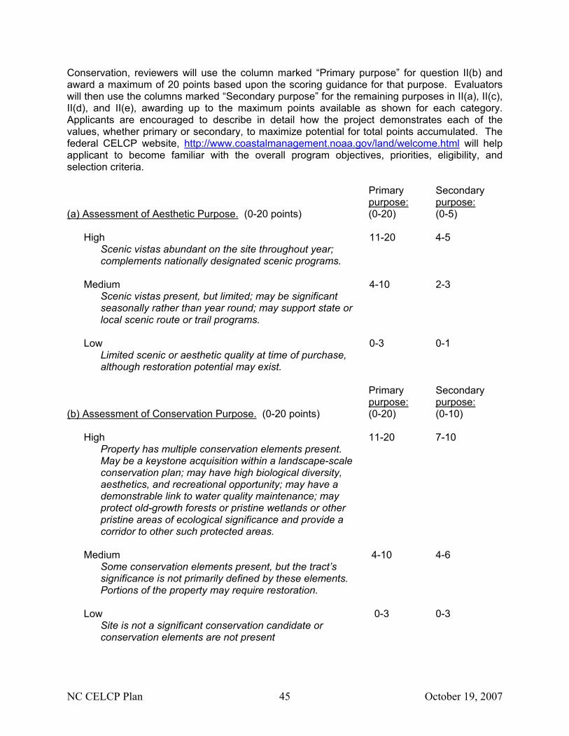
NC CELCP Plan 45 October 19, 2007
Conservation, reviewers will use the column marked “Primary purpose” for question II(b) and award a maximum of 20 points based upon the scoring guidance for that purpose. Evaluators will then use the columns marked “Secondary purpose” for the remaining purposes in II(a), II(c), II(d), and II(e), awarding up to the maximum points available as shown for each category. Applicants are encouraged to describe in detail how the project demonstrates each of the values, whether primary or secondary, to maximize potential for total points accumulated. The federal CELCP website, http://www.coastalmanagement.noaa.gov/land/welcome.html will help applicant to become familiar with the overall program objectives, priorities, eligibility, and selection criteria. Primary Secondary purpose: purpose: (a) Assessment of Aesthetic Purpose. (0-20 points) (0-20) (0-5)
High 11-20 4-5
Scenic vistas abundant on the site throughout year; complements nationally designated scenic programs.
Medium 4-10 2-3
Scenic vistas present, but limited; may be significant seasonally rather than year round; may support state or local scenic route or trail programs.
Low 0-3 0-1
Limited scenic or aesthetic quality at time of purchase, although restoration potential may exist.
Primary Secondary purpose: purpose: (b) Assessment of Conservation Purpose. (0-20 points) (0-20) (0-10)
High 11-20 7-10 Property has multiple conservation elements present. May be a keystone acquisition within a landscape-scale conservation plan; may have high biological diversity, aesthetics, and recreational opportunity; may have a demonstrable link to water quality maintenance; may protect old-growth forests or pristine wetlands or other pristine areas of ecological significance and provide a corridor to other such protected areas.
Medium 4-10 4-6
Some conservation elements present, but the tract’s significance is not primarily defined by these elements. Portions of the property may require restoration.
Low 0-3 0-3
Site is not a significant conservation candidate or conservation elements are not present
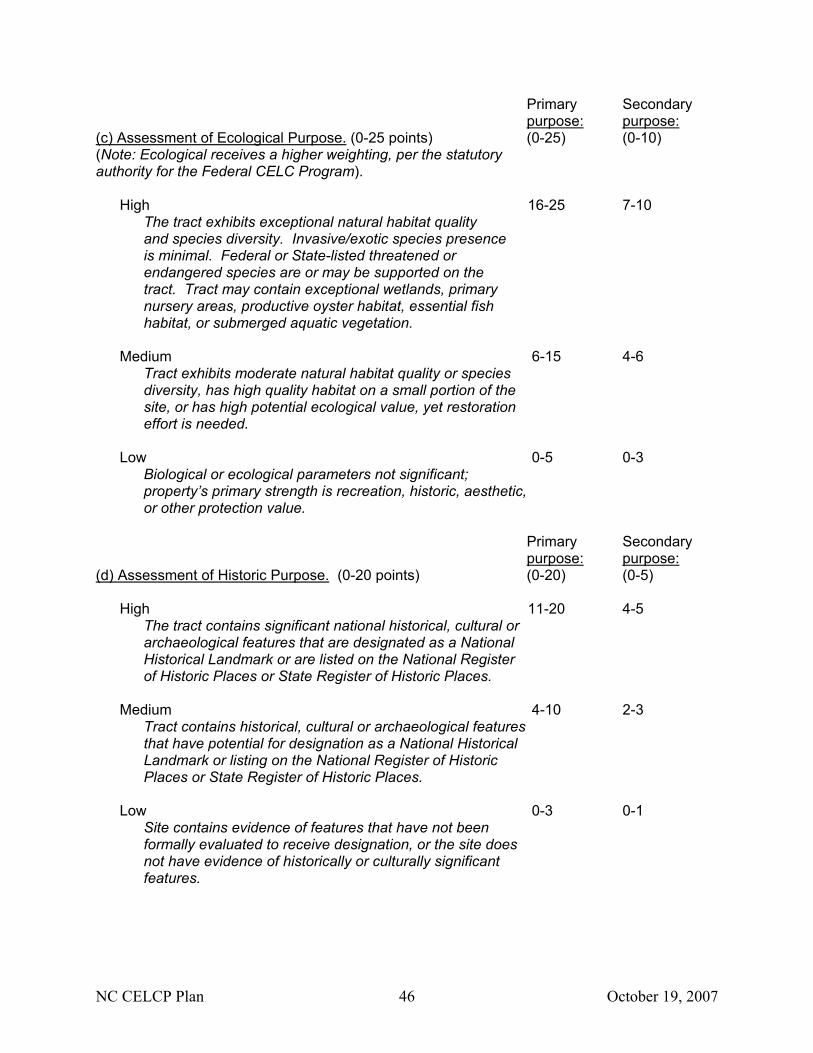
NC CELCP Plan 46 October 19, 2007
Primary Secondary purpose: purpose: (c) Assessment of Ecological Purpose. (0-25 points) (0-25) (0-10) (Note: Ecological receives a higher weighting, per the statutory authority for the Federal CELC Program).
High 16-25 7-10 The tract exhibits exceptional natural habitat quality and species diversity. Invasive/exotic species presence is minimal. Federal or State-listed threatened or endangered species are or may be supported on the tract. Tract may contain exceptional wetlands, primary nursery areas, productive oyster habitat, essential fish habitat, or submerged aquatic vegetation.
Medium 6-15 4-6
Tract exhibits moderate natural habitat quality or species diversity, has high quality habitat on a small portion of the site, or has high potential ecological value, yet restoration effort is needed.
Low 0-5 0-3
Biological or ecological parameters not significant; property’s primary strength is recreation, historic, aesthetic, or other protection value.
Primary Secondary purpose: purpose: (d) Assessment of Historic Purpose. (0-20 points) (0-20) (0-5)
High 11-20 4-5
The tract contains significant national historical, cultural or archaeological features that are designated as a National Historical Landmark or are listed on the National Register of Historic Places or State Register of Historic Places.
Medium 4-10 2-3
Tract contains historical, cultural or archaeological features that have potential for designation as a National Historical Landmark or listing on the National Register of Historic Places or State Register of Historic Places.
Low 0-3 0-1
Site contains evidence of features that have not been formally evaluated to receive designation, or the site does not have evidence of historically or culturally significant features.
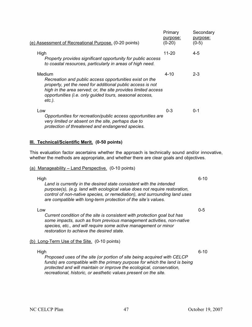
NC CELCP Plan 47 October 19, 2007
Primary Secondary purpose: purpose: (e) Assessment of Recreational Purpose. (0-20 points) (0-20) (0-5)
High 11-20 4-5
Property provides significant opportunity for public access to coastal resources, particularly in areas of high need.
Medium 4-10 2-3
Recreation and public access opportunities exist on the property, yet the need for additional public access is not high in the area served; or, the site provides limited access opportunities (i.e. only guided tours, seasonal access, etc.).
Low 0-3 0-1
Opportunities for recreation/public access opportunities are very limited or absent on the site, perhaps due to protection of threatened and endangered species.
III. Technical/Scientific Merit. (0-50 points) This evaluation factor ascertains whether the approach is technically sound and/or innovative, whether the methods are appropriate, and whether there are clear goals and objectives. (a) Manageability – Land Perspective. (0-10 points)
High 6-10
Land is currently in the desired state consistent with the intended purpose(s), (e.g. land with ecological value does not require restoration, control of non-native species, or remediation), and surrounding land uses are compatible with long-term protection of the site’s values.
Low 0-5
Current condition of the site is consistent with protection goal but has some impacts, such as from previous management activities, non-native species, etc., and will require some active management or minor restoration to achieve the desired state.
(b) Long-Term Use of the Site. (0-10 points)
High 6-10
Proposed uses of the site (or portion of site being acquired with CELCP funds) are compatible with the primary purpose for which the land is being protected and will maintain or improve the ecological, conservation, recreational, historic, or aesthetic values present on the site.
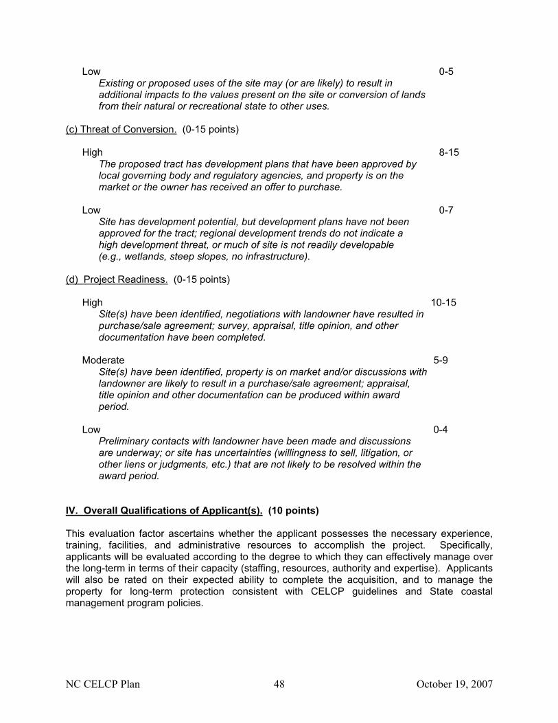
NC CELCP Plan 48 October 19, 2007
Low 0-5 Existing or proposed uses of the site may (or are likely) to result in additional impacts to the values present on the site or conversion of lands from their natural or recreational state to other uses.
(c) Threat of Conversion. (0-15 points)
High 8-15 The proposed tract has development plans that have been approved by local governing body and regulatory agencies, and property is on the market or the owner has received an offer to purchase.
Low 0-7
Site has development potential, but development plans have not been approved for the tract; regional development trends do not indicate a high development threat, or much of site is not readily developable (e.g., wetlands, steep slopes, no infrastructure).
(d) Project Readiness. (0-15 points)
High 10-15 Site(s) have been identified, negotiations with landowner have resulted in purchase/sale agreement; survey, appraisal, title opinion, and other documentation have been completed.
Moderate 5-9
Site(s) have been identified, property is on market and/or discussions with landowner are likely to result in a purchase/sale agreement; appraisal, title opinion and other documentation can be produced within award period.
Low 0-4
Preliminary contacts with landowner have been made and discussions are underway; or site has uncertainties (willingness to sell, litigation, or other liens or judgments, etc.) that are not likely to be resolved within the award period.
IV. Overall Qualifications of Applicant(s). (10 points) This evaluation factor ascertains whether the applicant possesses the necessary experience, training, facilities, and administrative resources to accomplish the project. Specifically, applicants will be evaluated according to the degree to which they can effectively manage over the long-term in terms of their capacity (staffing, resources, authority and expertise). Applicants will also be rated on their expected ability to complete the acquisition, and to manage the property for long-term protection consistent with CELCP guidelines and State coastal management program policies.

NC CELCP Plan 49 October 19, 2007
(a) Ability to Acquire Land – Agency Perspective. (0-5 points) Does the applicant have the proven capacity and/or experience, based on available funding, staff, authority and expertise, to execute the land transaction consistent with CELCP guidelines?
High 4-5 CELCP recipient has funding, personnel, expertise, legal authority and demonstrated success for acquiring lands, or interests in lands, for long-term conservation purposes.
Moderate 2-3
Funding or personnel appears to be limited; and/or state or local recipient appears to have a high caseload relative to resources;
Low 0-1
Applicant has not identified, or does not have, the personnel, funding resources, or authority to execute the project or to provide necessary assurances for long-term conservation.
(b) Ability to Manage Land – Agency Perspective. (0-5 points) Does the applicant have the proven capacity and experience, based on available funding, staff, authority and expertise, to manage property for long-term conservation of coastal and estuarine lands consistent with CELCP guidelines?
High 4-5 Applicant has funding and personnel or a partnership/stewardship agreement in place to manage new tract and has demonstrated success in managing other properties for conservation purposes. Applicant has satisfactory history with previous grants.
Moderate 2-3
Funding or personnel appears to be limited; and/or state or local recipient appears to have a high caseload relative to resources; funding, partnerships or stewardship agreements have been tentatively identified.
Low 0-1
Applicant has not identified, or does not have, the personnel or funding resources to accommodate the needed management of the tract.
V. Project Costs. (0-20 points) This evaluation factor determines if the project budget is realistic and commensurate with the project needs and timeframe. Specifically, the budget is evaluated to determine if land acquisition costs are based on an independent appraisal or other assessment of fair market value, if the source of matching funds is consistent with CELCP guidelines and is likely to be available within the performance period, and if direct and indirect costs for implementation of the project are reasonable and consistent with CELCP guidelines.
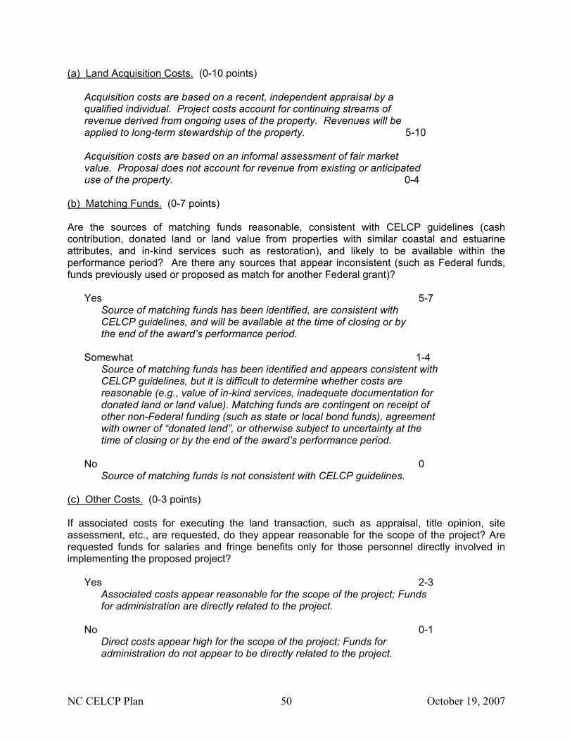
NC CELCP Plan 50 October 19, 2007
(a) Land Acquisition Costs. (0-10 points)
Acquisition costs are based on a recent, independent appraisal by a qualified individual. Project costs account for continuing streams of revenue derived from ongoing uses of the property. Revenues will be applied to long-term stewardship of the property. 5-10 Acquisition costs are based on an informal assessment of fair market value. Proposal does not account for revenue from existing or anticipated use of the property. 0-4
(b) Matching Funds. (0-7 points) Are the sources of matching funds reasonable, consistent with CELCP guidelines (cash contribution, donated land or land value from properties with similar coastal and estuarine attributes, and in-kind services such as restoration), and likely to be available within the performance period? Are there any sources that appear inconsistent (such as Federal funds, funds previously used or proposed as match for another Federal grant)?
Yes 5-7
Source of matching funds has been identified, are consistent with CELCP guidelines, and will be available at the time of closing or by the end of the award’s performance period.
Somewhat 1-4
Source of matching funds has been identified and appears consistent with CELCP guidelines, but it is difficult to determine whether costs are reasonable (e.g., value of in-kind services, inadequate documentation for donated land or land value). Matching funds are contingent on receipt of other non-Federal funding (such as state or local bond funds), agreement with owner of “donated land”, or otherwise subject to uncertainty at the time of closing or by the end of the award’s performance period.
No 0
Source of matching funds is not consistent with CELCP guidelines. (c) Other Costs. (0-3 points) If associated costs for executing the land transaction, such as appraisal, title opinion, site assessment, etc., are requested, do they appear reasonable for the scope of the project? Are requested funds for salaries and fringe benefits only for those personnel directly involved in implementing the proposed project?
Yes 2-3 Associated costs appear reasonable for the scope of the project; Funds for administration are directly related to the project.
No 0-1
Direct costs appear high for the scope of the project; Funds for administration do not appear to be directly related to the project.
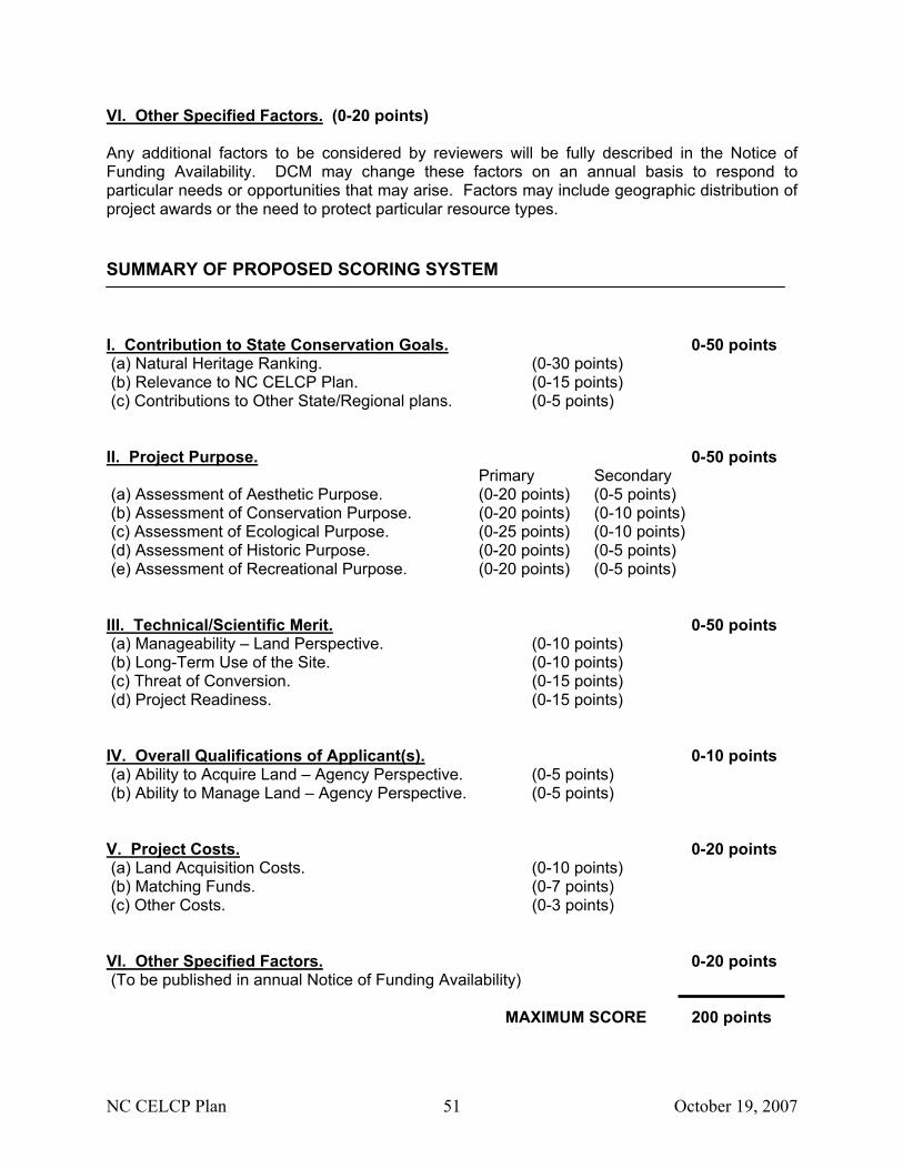
NC CELCP Plan 51 October 19, 2007
VI. Other Specified Factors. (0-20 points) Any additional factors to be considered by reviewers will be fully described in the Notice of Funding Availability. DCM may change these factors on an annual basis to respond to particular needs or opportunities that may arise. Factors may include geographic distribution of project awards or the need to protect particular resource types. SUMMARY OF PROPOSED SCORING SYSTEM I. Contribution to State Conservation Goals. 0-50 points (a) Natural Heritage Ranking. (0-30 points) (b) Relevance to NC CELCP Plan. (0-15 points) (c) Contributions to Other State/Regional plans. (0-5 points) II. Project Purpose. 0-50 points Primary Secondary (a) Assessment of Aesthetic Purpose. (0-20 points) (0-5 points) (b) Assessment of Conservation Purpose. (0-20 points) (0-10 points) (c) Assessment of Ecological Purpose. (0-25 points) (0-10 points) (d) Assessment of Historic Purpose. (0-20 points) (0-5 points) (e) Assessment of Recreational Purpose. (0-20 points) (0-5 points) III. Technical/Scientific Merit. 0-50 points (a) Manageability – Land Perspective. (0-10 points) (b) Long-Term Use of the Site. (0-10 points) (c) Threat of Conversion. (0-15 points) (d) Project Readiness. (0-15 points) IV. Overall Qualifications of Applicant(s). 0-10 points (a) Ability to Acquire Land – Agency Perspective. (0-5 points) (b) Ability to Manage Land – Agency Perspective. (0-5 points) V. Project Costs. 0-20 points (a) Land Acquisition Costs. (0-10 points) (b) Matching Funds. (0-7 points) (c) Other Costs. (0-3 points) VI. Other Specified Factors. 0-20 points (To be published in annual Notice of Funding Availability) MAXIMUM SCORE 200 points
NC CELCP Plan 52 October 19, 2007
IV. Coordination and Public Involvement A. Interagency coordination during plan development DCM contracted the NC Office of Conservation and Community Affairs (OCCA) to provide Open Space plans and GIS information for the State’s coastal counties. OCCA subcontracted with three regional Councils of Government to help fulfill the obligation to the Division of Coastal Management. The three Councils of Government were the Cape Fear Council of Government, the Eastern Carolina Council, and the Albemarle Commission. The councils held regional meetings in the fall of 2004, speaking with representatives from local governments, state agencies, private conservation groups, and interested citizens. The meetings helped to verify protected lands in each region and to identify potential conservation opportunities. These areas are identified on Geographic Information System (GIS) maps and open space plans. DCM held additional focus group and consulting meetings with state and federal agencies, collecting invaluable input and data that has been incorporated into this plan. Interested agencies were invited to participate over a period of two years and multiple meetings were held in the northern, central, and southern coastal plains. DCM worked directly with these agencies to share data and ideas for plan development. Agencies that participated in meetings, received copies of the draft plan and/or provided input include: NC Division of Parks & Recreation NOAA NC Division of Marine Fisheries US Fish & Wildlife Service NC Wildlife Resources Commission New Hanover County Soil & Water NC Office of Conservation & Community Affairs NC Department of Agriculture NC Clean Water Management Trust Fund NC Natural Heritage Program NC Environmental Management Commission Brunswick County NRCS
B. Public involvement in plan development DCM invited and received public involvement over the entire plan development time frame. Interested parties and private conservation partners attended Council of Government meetings in 2004 and submitted recommendations on important conservation areas and values. These were incorporated into the GIS maps and open space plans. DCM made multiple presentations at meetings of Coastal Resources Commission and Coastal Resources Advisory Council spanning the period 2004-2006, inviting input from Commission and Council members and from attending members of the public. DCM sponsored a table exhibit at the One NC Naturally Conference in Raleigh in March 2005 and again received public input. DCM participated in the Carolina Coastal Collaborative meetings in September 2005 and February 2006. These meetings were strongly attended by land conservation NGOs, who became directly involved in providing scoping input and reviewing the draft plan. The following is a summary of the public information and comment opportunities provided over the course of Plan development. Members of the public and interested parties have attended 23 meetings or events at which they were invited to provide scoping comments and feedback on the Draft Plan. The Draft was also available on DCM’s website for 12 weeks in the spring of 2006 for public review and input.
NC CELCP Plan 53 October 19, 2007
2004: • Eastern Carolina Council of Governments – nine meetings within their planning area • Cape Fear Council of Governments – two meetings within their planning area • Albemarle Commission – two meetings within their planning area
2005:
• Coastal Resources Commission & Advisory Council – two meetings • One North Carolina Naturally Annual Conference • Coastal Carolina Conservation Collaborative – one meeting
2006:
• Coastal Resources Commission & Advisory Council – one meeting • Coastal Carolina Conservation Collaborative – two meetings • Northern Coastal Plain Focus Group – one meeting • Duke University Graduate Symposia – two meetings • Division of Coastal Management website – comment draft posted for 12 weeks
2007:
• Stakeholder comment period – 45-day public comment period • Federal Consistency determination – 30-day comment period among state and federal
commenting agencies Organizations that participated in meetings, received copies of the draft plan and/or provided input include: Private NC Coastal Land Trust The Nature Conservancy NE New Hanover Conservancy Coastal Conservation League American Farmland Trust Black Family Land Trust Bald Head Island Conservancy Trust for Public Land Cape Fear Riverkeeper Conservation Trust for NC Waccamaw Riverkeeper Land Trust Alliance NC Coastal Federation Audubon NC Roanoke River Partnership Local Coastal county governments Coastal municipal governments Regional Councils of Government NC League of Municipalities State DENR Administration Division of Water Quality Division of Forest Resources Division of Marine Fisheries Department of Administration Division of Cultural Resources Department of Transportation Natural Heritage Program Department of Agriculture Attorney General’s Office Department of Commerce Division of Environmental Health Clean Water Management Trust Fund NC Sea Grant NC National Estuarine Research Reserve Office of Conservation & Community Affairs Albemarle-Pamlico National Estuary Program Division of Parks and Recreation
NC CELCP Plan 54 October 19, 2007
Federal US Fish and Wildlife Service National Park Service US Marine Corps US Navy US Army US Army Corps of Engineers NOAA Office of Ocean & Coastal Resource Management
NC CELCP Plan 55 October 19, 2007
V. Certification and Approval A. Certification that the plan is consistent the State’s approved coastal management program:
________________________________________ ____________________ Doug Huggett Date Major Permits & Federal Consistency Coordinator NC Division of Coastal Management
B. Approval of plan by designated official of State lead agency:
________________________________________ ____________________ James H. Gregson Date Director NC Division of Coastal Management
NC CELCP Plan 56 October 19, 2007
VI. References For further information on the programs and conservation planning initiatives mentioned within this report, please refer to the following web links: Conservation Plans: A Conceptual Plan for North Carolina’s Mountains-to-Sea Trail – Falls Lake Dam to Cedar Island. NC Division of Parks and Recreation. http://ils.unc.edu/parkproject/trails/mtst.html
New Parks for a New Century. NC Division of Parks and Recreation. http://ils.unc.edu/parkproject/explore/plan.html Mid-Atlantic Coastal Plain Ecoregional Plan. 2001. The Nature Conservancy – North Carolina Chapter. North Carolina Coastal Habitat Protection Plan. North Carolina Department of Environmental and Natural Resources. www.ncfisheries.net/habitat/index.html North Carolina National Estuarine Research Reserve Management Plan. North Carolina National Estuarine Research Reserve. www.ncnerr.org North Carolina Natural Heritage Program Biennial Protection Plan 2005. NC Office of Conservation and Community Affairs. www.ncnhp.org/Images/prioritylistfinal1.pdf North Carolina Wildlife Action Plan. North Carolina Wildlife Resources Commission. www.wildlife.state.nc.us/pg07_WildlifeSpeciesCon/pg7c1.htm One North Carolina Naturally Draft Plan. 2003. Office of Conservation and Community Affairs. www.onencnaturally.org/
Onslow Bight Conservation Design Plan (First Iteration Draft). 2005. Onslow Bight Conservation Forum. Oyster Restoration and Protection Plan – A Blueprint for Action 2003-2008. North Carolina Coastal Federation. www.nccoast.org/publication/oysterplan/index_html
Other Links of Interest: Audubon North Carolina. www.ncaudubon.org Important Bird Areas. http://www.ncaudubon.org/IBA_2004IBAsOfNC.html Cape Fear Council of Governments. www.capefearcog.org Eastern Carolina Council. www.eccog.org Mid-East Commission. www.mideastcom.org
NC CELCP Plan 57 October 19, 2007
NatureServe. www.natureserve.org North Carolina Ecosystem Enhancement Program. www.nceep.net North Carolina Division of Coastal Management. www.nccoastalmanagement.net North Carolina Division of Water Quality, surface water classifications. http://h2o.enr.state.nc.us/csu/swc.html#HQW North Carolina Farmland Preservation Program. www.ctnc.org/2farmhigh.htm
Information on this program is found through the Conservation Trust for North Carolina website. This non-profit was responsible for administering the Program between 1998 and 2003 when it received state funding.
North Carolina Clean Water Management Trust Fund. www.cwmtf.net North Carolina Natural Heritage Program. www.ncnhp.org North Carolina Natural Heritage Trust Fund. www.ncnhtf.org North Carolina Parks and Recreation Trust Fund. www.partf.net North Carolina Public Interest Research Group. www.ncpirg.org