Embed Size (px)
Citation preview
STATE OF MAINE
DEPARTMENT OF AGRICULTURE, CONSERVATION & FORESTRY
LAND USE PLANNING COMMISSION 22 STATE HOUSE STATION
AUGUSTA, MAINE 04333-0022
18 ELKINS LANE, HARLOW BUILDING
PHONE: 207-287-2631 www.maine.gov/acf FAX: 207-287-7439
WALTER E. WHITCOMB
COMMISSIONER
NICHOLAS D. LIVESAY
EXECUTIVE DIRECTOR
PAUL R. LEPAGE
GOVERNOR
Memorandum
To: LUPC Commissioners
From: Ben Godsoe, Senior Planner
Date: 12.2.2015
Re: Draft Bancroft Township Land Use Guidance Map
Having recently deorganized, Bancroft Township joined the area served by the Land Use Planning Commission on July 1st, 2015. State law requires that the Commission develop and adopt a land use guidance map for the township within one year of the effective date of deorganization.
This agenda item asks you to consider adoption of the proposed Bancroft Twp Land Use Guidance Map. Should the Commission choose to adopt the proposed map, it would become effective on December 24th, 2015. How did we get to this point?
Bancroft residents voted in favor of deorganization on November 4th, 2014. Over the next several months Commission staff worked to develop a draft zoning map for Bancroft Township.
At the June 10th, 2015 Commission Meeting, staff presented an update on the draft zoning map and described the remaining work that needed to be done to finalize the map. This was to include working with property owners and consultants to collect additional data in a few locations where mapped wetlands and flood prone areas overlapped existing structural development.
The Commission directed staff to finalize the draft zoning map and then post it for a 30 day public comment period before bringing it back to the Commission for consideration for adoption.
Since the June meeting, staff has worked with property owners and consultants to delineate wetland boundaries and collect more information about flood prone areas on 8 residential properties.
Zoning Petition ZP 756 – Proposed Bancroft Twp Land Use Guidance Map Page 2 of 3
The draft zoning map was posted for a 30 day public comment period from November 2nd, 2015 to December 2nd, 2015.
Process for developing the proposed map: In order to generate the proposed zoning map, staff conducted an extensive inventory of existing land use conditions in Bancroft that included mapping existing development, water resources, and other natural features. This process also included significant efforts to engage residents and property owners about appropriate locations for future growth through public meetings, interpersonal outreach, mailings, and use of the Commission’s website to reach property owners who are not residents.
Public input opportunities included:
On January 22nd, 2015 staff were available during an “open house” at the town office to answer questions;
A public informational meeting held in Bancroft on March 19th, which included a brief overview of land use services offered by the agency, staff presentation of three resource maps generated as part of the land use inventory, and discussion with participants about the potential locations for future development zoning;
A second public meeting held in Bancroft on May 7, 2015, where staff presented and discussed a draft preliminary land use guidance map, which was also posted on the Commission’s website with materials from both public meetings; and
A 30 day public comment period from November 2, 2015 to December 2, 2015 where anyone could comment on the proposed map, or request a public hearing.
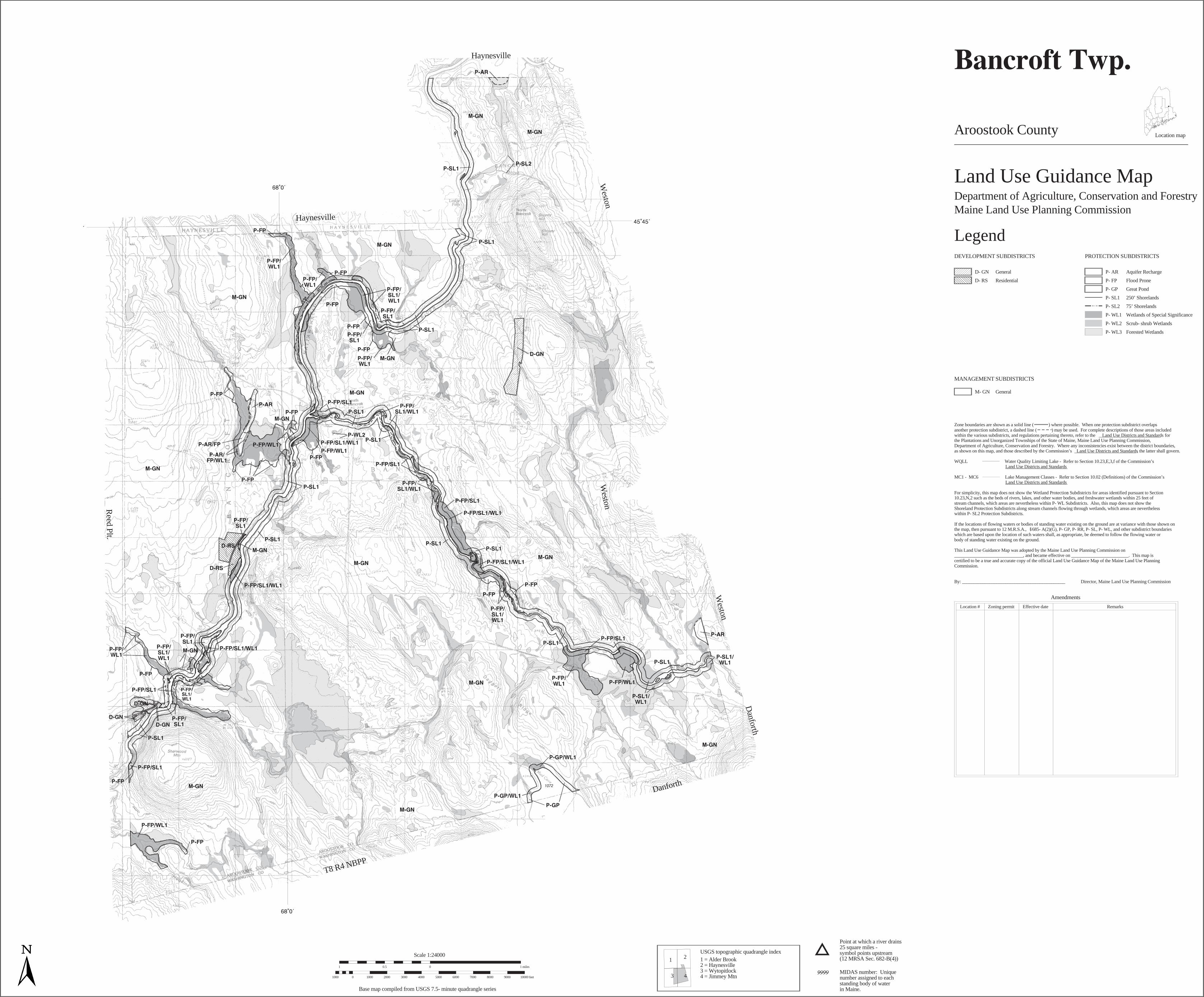
Proposed Zoning1: Development Subdistricts: There are three locations in Bancroft proposed to be Development Subdistricts. All are based on existing development densities and uses. Some of them extend to adjacent properties in order to accommodate future growth and planned activities. Two of these locations would be General Development (D-GN) Subdistricts and were identified by residents during the public meetings as places that either already include or would be appropriate for future small-scale commercial development. The remaining development zone would be a D-RS (Residential
1 While this proposed zoning for Bancroft Township does not affect Bancroft’s status with respect to the expedited permitting area
for wind energy development, the deorganization of Bancroft did affect its status. Prior to deorganization Bancroft was included in the expedited area, along with all other organized municipalities in the state, pursuant to the Wind Energy Act which includes “the organized areas in the State in their entirety.”(34-A M.R.S. §3451(3)(A)). After deorganization, Bancroft now is no longer part of the expedited area on the basis of being organized. Within the State’s unorganized and deorganized areas, the Wind Energy Act includes in the expedited area only “specific places … that are identified by rule by the Maine Land Use Planning Commission in accordance with this chapter.” (34-A M.R.S § 3451(3)(B)). Bancroft is not identified in the Commission’s chapter 10 rules and therefore is not within the expedited permitting area.
Zoning Petition ZP 756 – Proposed Bancroft Twp Land Use Guidance Map Page 3 of 3
Development) Subdistrict, and would include an existing residential neighborhood with a relatively dense pattern of development. Management Subdistricts: Large portions of Bancroft are managed as working forest or agricultural land and would be appropriate for the General Management (M-GN) Subdistrict. For the most part, we propose placing these areas in the M-GN Subdistrict unless they qualified for placement in Protection Subdistricts or were identified during the public meetings as being an appropriate place to direct future residential or commercial development. Protection Subdistricts: A number of areas in Bancroft qualify for protection subdistrict zoning. Among those proposed for Bancroft include protection subdistricts for aquifers (P-AR), flood protection (P-FP), great pond protection (P-GP), shoreland protection (P-SL), and wetland protection (P-WL).
Finalization of Protection Subdistrict boundaries on eight residential properties: In a few locations near the Mattawamkeag River and Baskahegan Stream, mapped wetlands and flood prone areas overlapped existing structural development and the Commission directed staff to work with property owners to obtain more detailed information to ensure proposed zoning would accurately reflect conditions on the ground. The wetland protection and flood prone area protection subdistrict boundaries in the attached draft zoning map reflect data collected as part of this effort. Consultations with property owners and in some cases more formal wetland delineation by consultants yielded accurate boundaries of existing wetlands at each site. In two locations, proposed subdistrict boundaries could clearly be adjusted to more accurately reflect what was on the ground. Boundaries of existing wetlands were less clear in the remaining 6 locations and staff used funds, set aside by the town prior to deorganization for development of the zoning map, to hire consultant Boyle Associates to delineate wetland boundaries. The site visits and subsequent delineation project also yielded additional information about the presence of Mixed Alluvial Soils at these sites, which forms the basis for a flood prone area protection subdistrict.
Public Comments: No comments were received from the public during the comment period. Staff submitted a comment during the public comment period that included additional information from Boyle Associates pertaining to two of the sites where the boundaries of wetland protection subdistricts were delineated and adjusted to exclude existing development. The additional information warranted minor, non-substantive, boundary adjustments at one site, and the reclassification of a wetland at another site resulting in it going from a P-WL3 to a P-WL2 subdistrict. In both cases property owners were notified of the proposed changes and did not raise any objections. The proposed zoning map included in Attachment 1 reflects these changes. Staff Recommendation: Staff recommends the Commission adopt the draft Bancroft Township Land Use Guidance Map and approve Zoning Petition ZP 756, which would become effective on12.24.2015. Attachment 1: Draft Bancroft Township Land Use Guidance Map Attachment 2: Zoning Petition ZP 756 Decision Document
Haynesville
Weston
Weston
Weston
Danforth
Danforth
T8 R4 NBPP
Reed Plt.
Haynesville
Aroostook County
Land Use Guidance MapDepartment of Agriculture, Conservation and ForestryMaine Land Use Planning Commission
LegendDEVELOPMENT SUBDISTRICTS
D- GN General
D- RS Residential
MANAGEMENT SUBDISTRICTS
M- GN General
PROTECTION SUBDISTRICTS
P- AR Aquifer Recharge
P- FP Flood Prone
P- GP Great Pond
P- SL1 250’ Shorelands
P- SL2 75’ Shorelands
P- WL1 Wetlands of Special Significance
P- WL2 Scrub- shrub Wetlands
P- WL3 Forested Wetlands
Zone boundaries are shown as a solid line ( ) where possible. When one protection subdistrict overlapsanother protection subdistrict, a dashed line ( ) may be used. For complete descriptions of those areas includedwithin the various subdistricts, and regulations pertaining thereto, refer to the Land Use Districts and Standards___________________________ forthe Plantations and Unorganized Townships of the State of Maine, Maine Land Use Planning Commission,Department of Agriculture, Conservation and Forestry. Where any inconsistencies exist between the district boundaries,as shown on this map, and those described by the Commission’s Land Use Districts and Standards___________________________ , the latter shall govern.
WQLL _______________ Water Quality Limiting Lake - Refer to Section 10.23,E,3,f of the Commission’sLand Use Districts and Standards___________________________
:MC1 - MC6 _______________ Lake Management Classes - Refer to Section 10.02 (Definitions) of the Commission’sLand Use Districts and Standards___________________________
:For simplicity, this map does not show the Wetland Protection Subdistricts for areas identified pursuant to Section10.23,N,2 such as the beds of rivers, lakes, and other water bodies, and freshwater wetlands within 25 feet ofstream channels, which areas are nevertheless within P- WL Subdistricts. Also, this map does not show theShoreland Protection Subdistricts along stream channels flowing through wetlands, which areas are neverthelesswithin P- SL2 Protection Subdistricts.
If the locations of flowing waters or bodies of standing water existing on the ground are at variance with those shown onthe map, then pursuant to 12 M.R.S.A., 685- A(2)(G), P- GP, P- RR, P- SL, P- WL, and other subdistrict boundarieswhich are based upon the location of such waters shall, as appropriate, be deemed to follow the flowing water orbody of standing water existing on the ground.
This Land Use Guidance Map was adopted by the Maine Land Use Planning Commission on______________________________, and became effective on _________________________. This map iscertified to be a true and accurate copy of the official Land Use Guidance Map of the Maine Land Use PlanningCommission.
By: _____________________________________________ Director, Maine Land Use Planning Commission
Amendments
Location # Zoning permit Effective date Remarks
Location map
USGS topographic quadrangle index
1 1 = Alder Brook2
2 = Haynesville
33 = Wytopitlock
4 4 = Jimmey Mtn
Point at which a river drains25 square miles -symbol points upstream(12 MRSA Sec. 682-B(4))
MIDAS number: Uniquenumber assigned to eachstanding body of waterin Maine.
1 0 1 miles0.5
Scale 1:24000
1000 0 1000 2000 3000 4000 5000 6000 7000 8000 9000 10000 feet
Base map compiled from USGS 7.5- minute quadrangle series
STATE OF MAINE
DEPARTMENT OF AGRICULTURE, CONSERVATION & FORESTRY
LAND USE PLANNING COMMISSION 22 STATE HOUSE STATION
AUGUSTA, MAINE 04333-0022
WALTER E. WHITCOMB
COMMISSIONER
NICHOLAS D. LIVESAY
EXECUTIVE DIRECTOR
PAUL R. LEPAGE
GOVERNOR
COMMISSION DECISION
IN THE MATTER OF
Establishment of Zoning in Bancroft Township as a result of Municipal Deorganization
Finding of Fact and Decision (DRAFT)
ZONING PETITION ZP 756 The Maine Land Use Planning Commission (the LUPC or Commission), at a meeting of the Commission held December 9, 2015 at Presque Isle, Maine, after reviewing the petition and supporting documents submitted by staff (the petitioner) for Zoning Petition ZP 756, review agency and public comments, and other related materials on file, pursuant to 12 M.R.S Sections 681 et. Seq. and the Commission’s rules, finds the following facts:
1. Petitioner: Commission Staff (attention: Ben Godsoe) Maine Land Use Planning Commission 22 State House Station Augusta, ME 04333
2. Date of Completed Petition: 10/28/2015
3. Proposal Location: Bancroft Township, southern Aroostook County
4. Acres to be Zoned: 26,256
5. Affected Waterbodies: Lower Hot Brook Lake; Mattawamkeag River, Baskahegan Stream
6. Present Zoning: None
7. Proposed Zoning:
General Management Subdistrict (M-GN) General Development Subdistrict (D-GN) Residential Development Subdistrict (D-RS) Aquifer Resource Protection Subdistrict (P-AR) Flood Prone Areas Protection Subdistrict (P-FP) Great Pond Protection Subdistrict (P-GP) Shore Land Zoning Protection Subdistrict (P-SL1 and P-SL2) Wetland Protection Subdistrict (P-WL1, P-WL2, and P-WL3)
Zoning Petition ZP 756; Establishment of Zoning in Bancroft Township due to Municipal Deorganization
2
Administrative Background
8. The town of Bancroft submitted a petition to the Maine Commission on Municipal Deorganization to deorganize. Bancroft then held a special town meeting to discuss the impacts of deorganization on May 3, 2012 and voted in favor of deorganizing.1 They appointed a citizen committee to develop a deorganization procedure and then submitted it to the Maine Commission on Deorganization on July 13, 2012. The procedure was formally accepted and the town scheduled a special town meeting to discuss and vote on the deorganization procedure. The 126th Maine Legislature approved deorganization of the Town of Bancroft, as described in Public Law 2013, Chapter 390.2 Residents of Bancroft issued final approval for the town to deorganize, in accordance with 30-A M.R.S. § 7209, during general elections held November 14, 2014. In accordance with 30-A M.R.S. § 7205(5), the Commission has one year from the effective date of deorganization, July 1, 2015, to adopt zoning for Bancroft Twp.
9. Commission staff hosted an informal open house on January 22, 2015. Commission representatives were available during regular hours at the Bancroft town office to answer questions that residents or property owners had about the deorganization process and land use services provided by the Commission.
10. A public informational meeting was held on March 19, 2015 and included an introduction to land use services provided by the Commission, as well as an overview of the prospective zoning process.3 Participants had a chance to review a series of maps depicting natural resources and existing development in Bancroft and to discuss likely zoning based on existing natural resources. Meeting participants, including current and prospective business owners, were encouraged to comment on what they would like for their town and to indicate where it would be appropriate to have development subdistricts.
11. A draft zoning map was developed based on the information depicted in the series of resource maps shown to property owners in Bancroft at the March 19, 2015 meeting.4 A second public informational meeting was held on May 7, 2015, and focused primarily on review of the draft zoning map. Participants were able to see the map, ask questions, and make comments. During further review of the draft map, it came to the Commission’s attention that several proposed P-WL and P-FP subdistricts, which are based on information contained in the National Wetlands Inventory and USGS soils dataset, overlapped existing structural development. In these locations, Commission staff proposed to work closely with property owners and consultants to gather better information about existing soils at each site and more accurately delineate the boundaries of mapped wetlands and flood prone areas that overlapped existing structural development.
12. On June 10, 2015 the Commission directed staff to proceed with the wetland delineation for certain identified properties in order to finalize the draft land use guidance map, and then to
1 Staff attended the meeting on May 3, 2012 and made an informational presentation.
2 The Deorganization Procedure for the Town of Bancroft and Public Law 2013, Chapter 390 are included as Exhibit
O, Items 2 & 4, in application materials for ZP 756. 3 Public Informational Meeting materials are included as Exhibit O, Item 3 in application materials for ZP 756.
4 The draft ‘Land Use Guidance Map for Bancroft Twp’ is included as Exhibit A in application materials for ZP 756.
Zoning Petition ZP 756; Establishment of Zoning in Bancroft Township due to Municipal Deorganization
3
initiate a public comment period.5 Wetland delineation was done on: 9/28/2015; 9/29/2015; 10/15/2015; and 10/28/2015. Once the P-FP and P-WL subdistrict boundaries were finalized, based on information obtained during wetland delineation by consultants, Staff initiated a 30 day public comment period from November 2, 2015 to December 2, 2015.
Public Notice
13. Notice of the proposed zoning petition was properly made to appropriate parties and the public as required under Chapter 4 of the Commission’s rules. Notice of public informational meetings held in Bancroft was sent by mail to all property owners based on contact information provided by the town. Additionally, posters advertising the meetings were posted in a public, visible place in Bancroft. The Commission developed a webpage6 for the deorganization project and posted information about, and materials for, public meetings online. Over the course of the project, staff regularly corresponded with property owners who could not make it to the meetings but wanted to ask questions or make comments.
Project Information
14. The petitioner proposes establishment of management, development and protection districts within the township of Bancroft. Establishment of zoning would extend sound principles of planning, zoning, and development to Bancroft Twp as it joins the deorganized and unorganized areas of the state and comes under the jurisdiction of the LUPC.
15. The Commission prospectively zones Minor Civil Divisions (MCDs) that become part of the Jurisdiction after deorganizing. Prospectively zoning an entire township entails: identification in a land use inventory of existing natural resources eligible for inclusion in protection or management subdistricts; and identification of existing development and appropriate locations for future growth, which forms the basis for establishing development subdistricts. The petitioner developed a series of maps, based on existing data that describes existing natural resources and existing development in Bancroft. Information about existing natural resources was obtained through the Maine Office of GIS and through discussions with state and federal agencies.7 The locations of existing structural development were verified during a land use windshield survey, conducted January 22, 2015 – January 23, 2015,8 and through outreach to individual property owners. Resource maps developed during the land use survey represent the best available data for the new township and are grouped into three broad topic areas:
A. Water Resources. This map shows the location of hydrologic features such as lakes,
ponds, rivers, and streams; significant sand and gravel aquifers (glacial deposits that are
5 Minutes from the June 10, 2015 Commission Meeting in Brewer are included as Exhibit O, Item 5 in application
materials for ZP 756. 6 Bancroft Deorganization Website:
http://www.maine.gov/dacf/lupc/projects/deorganization/bancroft_deorg.html 7 A complete list of sources can be found in Exhibit O, Item 1 in application materials for ZP 756.
8 Survey included visual verification from public roads of location and use of existing structural development.
Zoning Petition ZP 756; Establishment of Zoning in Bancroft Township due to Municipal Deorganization
4
significant ground water resources); wetlands depicted in the National Wetlands Inventory (NWI); and 10 foot contour intervals showing changes in elevation.9 Lower Hot Brook Lake is located on the southern boundary between T8 R4 WELS and Bancroft with only the northern portion of the lake in Bancroft. Lower Hot Brook Lake is approximately 713 acres, resource class 3, and characterized as inaccessible and undeveloped by the Maine Wildlands Lake Assessment Findings (Chapter 10, Appendix C). The Mattawamkeag River from the Reed Plantation and Bancroft Township town line to the East Branch, including its tributaries (e.g., Baskahegan Stream in Bancroft), is considered a Significant River Segment identified in 38 M.R.S. § 437. The Maine Rivers Study (Maine Dept. of Conservation, 1982) identified the sections of the Mattawamkeag River and Baskahegan Stream in Bancroft as Level B Rivers, exhibiting some outstanding characteristics of statewide significance. Both are noted for their undeveloped shoreline, scenic character, and recreational resources for canoe-touring and whitewater activities.10
B. Soil Resources. This map shows the locations of different soil profiles in the township
according to the National Cooperative Soil Survey (US Department of Agriculture Soil Conservation Service Southern Aroostook County Soil Survey). There currently are no Flood Insurance Studies, Flood Insurance Rate Maps (FIRM), Floodway Maps, or Flood Hazard Maps prepared by FEMA. Bancroft does not have an established Base Flood Elevation (BFE).11
C. Existing Development. This map shows existing property boundaries; structural development and known commercial, residential and municipal land uses; road networks; municipal facilities (e.g., sand/salt storage, cemetery, town office, etc.); and other development.12
D. Other Special Natural Resources. Mapped information about wildlife habitat in Bancroft, including deer wintering areas and Inland Wading and Water Bird Habitat (IWWH) developed by the Maine Department of Inland Fisheries and Wildlife, and adopted in rule by the Maine Department of Environmental Protection pursuant to the Natural Resources Protection Act (NRPA).13
E. Revised Other Special Natural Resources. A revised version of this map was developed after the Maine Natural Areas Program (MNAP) submitted newly mapped resources on
9 Water Resources Map can be found in Exhibit G, Item 1 in application materials for ZP 756.
10 Applicable excerpts from the Maine Rivers Study (Dept. of Conservation, 1982) can be found in Exhibit O, Item 6
in application materials for ZP 756. 11
Soil Resources Maps can be found in Exhibit E in application materials for ZP 756. 12
Existing Development Map can be found in Exhibit O, Item 2 in application materials for ZP 756. 13
Other Special Natural Resources Map can be found in Exhibit G, Item 2 in application materials for ZP 756.
Zoning Petition ZP 756; Establishment of Zoning in Bancroft Township due to Municipal Deorganization
5
November 5, 2015, during the public comment period. This map utilized the new data to depict a silver maple floodplain along Baskahegan Stream.14
Proposed New Zoning
16. New zones would be based on existing natural resources, existing development, and input from property owners and appropriate state or federal agencies. The following subdistricts are proposed in Bancroft:
A. General Development Subdistrict (D-GN). The D-GN subdistrict recognizes existing patterns of development in appropriate areas and encourages further compatible development therein and adjacent thereto. It is the Commission’s intent to promote these areas as future growth centers and encourage the general concentration of future development. Two areas were identified by Commission staff as being appropriate for the General Development subdistrict. The two areas proposed for a D-GN Subdistrict include:
I. Kelly Road D-GN: The boundaries of the D-GN located on Kelly Road were drawn
in consultation with property owners to include existing businesses and structures, and to incorporate enough additional area to accommodate planned small-scale commercial uses, but to exclude resources within proposed protection subdistricts.
II. Schoolhouse Road D-GN: The boundaries of the D-GN located on Schoolhouse
and Bancroft Roads, in the southwest corner of the township, were drawn to include existing structures and exclude known natural resources that would otherwise be included in protection subdistricts. The proposed D-GN would include the former town office and veteran’s memorial. The subdistrict is contiguous and includes areas within 250 feet of public roads along School House Road and a portion of Bancroft Road.
B. Residential Development Subdistrict (D-RS). The D-RS subdistrict is intended to set aside
certain areas for residential and other appropriate uses so as to provide for residential activities apart from commercial development. The Commission’s intention is to encourage residential development in and adjacent to existing, similarly developed areas. One D-RS subdistrict is proposed along Bancroft Road, in an area where four or more single family dwelling units exist within a 500 foot radius15, and are in a recorded single family residential subdivision.
C. General Management Subdistrict (M-GN). The General Management Subdistrict is
proposed in areas that do not qualify for any other subdistrict and is intended to permit forestry and agricultural management activities to occur with minimal interferences from unrelated development in areas where the Commission finds that the resource
14
Revised Other Special Natural Resources Map can be found in Exhibit G, Item 3 in application materials for ZP 756. 15
The D-RS subdistrict description in Chapter 10 Land Use Districts and Standards (Section 10.21,J,2) contains this language, which pertains to the density of residential development within the subdistrict.
Zoning Petition ZP 756; Establishment of Zoning in Bancroft Township due to Municipal Deorganization
6
protection afforded by protection subdistricts is not required. In Bancroft Township, these areas are currently low density, dispersed residential development, or actively managed for agricultural or forestry activities.
D. Aquifer Resource Protection Subdistricts (P-AR). The P-AR subdistrict is proposed in three locations where information from the Maine Geological Survey indicates significant sand and gravel aquifers mapped at a scale of 1:24,000. These identified aquifers consist of glacial soil deposits and are a significant ground water resource for Maine. All three areas proposed for a P-AR subdistrict are classified as ATYPE1, and are expected to yield 10-50 gallons per minute for a properly constructed well. Two of the proposed P-ARs include small portions of aquifers that are mostly located in nearby Haynesville and Danforth.
E. Flood Prone Area Protection Subdistricts (P-FP). The P-FP subdistrict is proposed in areas identified as being within the 100 year flood plain, based on information about soils from the National Cooperative Soil Survey (US Department of Agriculture Soil Conservation Service Southern Aroostook County Soil Survey), and additional information about historic flooding activity and the presence of fill at developed sites obtained by staff and consultants during site visits. Specifically, P-FP subdistricts would include soils identified in the National Cooperative Soil Survey as “Mixed Alluvial Lands”.
F. Great Pond Protection Subdistrict (P-GP). The P-GP subdistrict is proposed for areas within 250 feet of the shoreline of Lower Hot Brook Lake within Bancroft Township, which is 713 acres and is characterized by the Wildlands Lake Assessment as resource Class 3, inaccessible, and undeveloped. Shoreland Protection Subdistricts (P-SL1 and P-SL2). The P-SL1 subdistrict is proposed in areas within 250 feet of the normal high water mark of flowing waters within Bancroft Township that drain more than 50 square miles. The P-SL2 subdistrict is proposed in areas within 75 feet of the normal high water mark of flowing waters within Bancroft Twp that drain 50 square miles or less. Generally this includes, but is not limited to, the Mattawamkeag River and all of its tributaries.
G. Wetland Protection Subdistricts (P-WL1, P-WL2, and P-WL3). Wetland Protection Subdistricts are proposed throughout the township and would include areas identified in the National Wetlands Inventory (NWI), and through identification in the field, as: emergent wetlands (included in proposed P-WL1 subdistricts); scrub-shrub wetlands (included in proposed P-WL2 subdistricts); and forested wetlands (included in proposed P-WL3 subdistricts).
Review Criteria
17. Under 12 M.R.S § 685-A(8-A) of the Commission’s Statutes, and Section 10.08 of the Commission’s Land Use Districts and Standards, “A land use district boundary may not be adopted or amended unless there is substantial evidence that:
Zoning Petition ZP 756; Establishment of Zoning in Bancroft Township due to Municipal Deorganization
7
A. The proposed land use district is consistent with the standards for district boundaries in effect at the time, the comprehensive land use plan and the purpose, intent and provisions of this chapter;16 and
B. The proposed land use district has no undue adverse impact on existing uses or resources or a new district designation is more appropriate for the protection and management of existing uses and resources within the affected area.”
18. Sections 10.21, 10.22, and 10.23 of Chapter 10, Land Use Districts and Standards, sets out the
subdistrict purpose and descriptions for each of the proposed subdistricts as follows:
A. 10.21,C,1: General Development Subdistrict (D-GN).“The Purpose of the General Development Subdistrict is to recognize existing patterns of development in appropriate areas and to encourage further patterns of compatible development therein and adjacent thereto. It is the Commission’s intent to promote these areas as future growth centers in order to encourage the location of compatible development near each other and to minimize the impact of such development upon incompatible uses and upon public services and facilities. Thus the Commission’s purpose is to encourage the general concentration of new development, and thereby avoid the fiscal and visual costs of sprawl, and to provide a continuing sense of community in settled areas.”
Chapter 10, Section 10.21,C,2,a,(1) describes D-GN subdistricts as “Areas with the following patterns of existing intensive development use: (1) Areas where 4 or more principal buildings exist within a 500 foot radius provided that one or more of such buildings is other than a single family detached dwelling unit; and all such buildings are compatible with such residential units; or…”.
Chapter 10, Section 10.21,C,2,b describes D-GN subdistricts as “Areas which the Commission determines meet the criteria for redistricting to this subdistrict, pursuant to Section 10.08 hereof, are proposed for development which is consistent with the purposes of this subdistrict, and are suitable for the development activities proposed when measured against the standards of 12 M.R.S.A. § 685-B(4) and the Commission's Rules and Regulations relating thereto.”
B. Residential Development Subdistrict (D-RS). “The Purpose of the D-RS subdistrict is to set aside certain areas for residential and other appropriate uses so as to provide for residential activities apart from areas of commercial development. The intention is to encourage the concentration of residential type development in and adjacent to existing residentially developed areas.” (10.21,J,1)
Chapter 10, Section 10.21,J,2,b describes D-RS subdistricts as “Areas with the following existing patterns of intensive residential development: (1) Areas where four or more single family dwelling units exist within a 500 foot radius; … The designated D-RS subdistrict boundaries shall include all single family dwelling units and accessory buildings and uses, paved areas and areas directly related to, and necessary for, the conduct of those activities associated with the above described single family dwelling
16
Criteria A is discussed below in findings 18, A – H. Discussion of Criteria B is included later under “Impacts on Existing Uses and Resources, on page 16.
Zoning Petition ZP 756; Establishment of Zoning in Bancroft Township due to Municipal Deorganization
8
units, as well as other intervening areas between such buildings, paved surfaces and areas…”
Chapter 10, Section 10.21,J,2,b describes D-RS subdistricts as “Areas which the Commission determines meet the criteria for redistricting to this subdistrict, pursuant to Section 10.08 hereof, are proposed for development which is consistent with the purposes of this subdistrict, and are suitable for the development activities proposed when measured against the standards of 12 M.R.S.A. §685-B(4) and the Commission's Rules and Regulations relating thereto.”
C. General Management Subdistrict (M-GN). “The purpose of the M-GN subdistrict is to permit forestry and agricultural management activities to occur with minimal interferences from unrelated development in areas where the Commission finds that the resource protection afforded by protection subdistricts is not required.” (10.22,A,1)
D. Aquifer Protection Subdistrict (P-AR). “The purpose of the P-AR Subdistrict is to protect the quantity and quality of ground water supply used or potentially available for human or industrial consumption.” (10.23,B,1)
Chapter 10, Section 10.23,B,2 describes P-AR subdistricts as “Areas identified by the Commission as having soil rated as highly permeable and/or surficial geologic units that are highly permeable and are hydrologically connected through highly fractured bedrock units to a ground water supply which is currently, or anticipated to be, used for public, industrial, or agricultural purposes, or areas identified by the Commission as aquifer recharge areas based on studies by appropriate qualified persons or agencies where the Commission determines that such areas warrant water quality protection.”
E. Flood Prone Area Protection Subdistrict (P-FP). “The purpose of the P-FP subdistrict is to regulate in all flood prone areas, including areas of special flood hazard, certain land use activities in order to minimize the human, environmental, and financial costs of floods and flood cleanup programs, by protecting on-site, adjacent, upstream and downstream property from flood damage; and by minimizing danger from malfunctioning water supply and waste disposal systems in flood prone areas; and to comply with the cooperative agreement between the LUPC and the Federal Emergency management Agency (FEMA) regarding the regulation of land use according to the requirements of 44 CFR Part 60.3 of the National Flood Insurance Program, so that flood insurance can be made available to persons in flood prone areas” (10.23,C,1).
Chapter 10, Section 10.23,C,2 describes P-FP subdistricts as “Areas located within the 100 year floodplain, also known as areas of special flood hazard, as identified by the Commission after consideration of relevant data including, without limitation, areas determined to be flood prone by state or federal agencies, including the flood Insurance Studies and accompanying Flood Insurance Rate Maps, Flood Boundary and Floodway Maps or Flood Hazard Boundary Maps prepared by the Federal Emergency Management Agency, historical data, and the National Cooperative Soil Survey.
F. Great Pond Protection Subdistrict (P-GP). “The Purpose of the P-GP subdistrict is to regulate residential and recreational development on Great Ponds to protect water quality, recreation potential, fishery habitat, and scenic character” (10.23,E,1).
Zoning Petition ZP 756; Establishment of Zoning in Bancroft Township due to Municipal Deorganization
9
Chapter 10, Section 23,E,2 describes the P-GP subdistrict as: “Areas within 250 feet of the normal high water mark, measured as a horizontal distance landward of such high water mark, of those bodies of standing water 10 acres or greater in size.”
G. Shoreland Protection Subdistrict (P-SL). “The purpose of the P-SL subdistrict is to regulate certain land use activities in certain shoreland areas in order to maintain water quality, plant, fish, and wildlife habitat and in order to protect and enhance scenic and recreational opportunities” (10.23,L,1).
The P-SL subdistrict includes two designations: (i) “P-SL1: Areas within 250 feet of the normal high water mark, measured as horizontal distance landward of such high water mark, of (a) coastal wetlands, and (b) flowing waters downstream from the point where such waters drain 50 square miles or more; and (ii) “P-SL2: Areas within 75 feet, measured as a horizontal distance landward, of (a) the normal high water mark of flowing waters upstream from the point where such channels drain 50 square miles; (b) the upland edge of those freshwater wetlands identified in Section 10.23,N,2,a,(1),(c) and (2), and (3); and (c) the normal high water mark of bodies of standing water less than 10 acres in size, but excluding bodies of standing water which are less than three acres in size and which are not fed or drained by a flowing water” (10.23,L,2).
H. Wetland Protection Subdistricts Description (P-WL): “The purpose of the P-WL subdistrict is to conserve coastal and freshwater wetlands in essentially their natural state because of the indispensable biologic, hydrologic and environmental functions which they perform.
Preserving wetlands will promote the public health and safety of persons and protect property against the hazards of flooding and drought by holding back water during floods and retaining water during dry periods. Wetlands also maintain water quality for drinking, store nutrients from upland run-off in plant tissue, serve as settling basins for silt and sediment from upland erosion, stabilize water supply by maintaining the groundwater table and groundwater recharge and discharge areas, and provide plant, fish and wildlife habitat. Wetlands function as integral and irreplaceable parts of a larger natural system, influencing our climate, economy, environment, and natural heritage.
Insofar as this protection subdistrict also includes the area enclosed by the normal high water mark of surface water bodies within the Commission's jurisdiction, the purpose of this subdistrict shall also be to help insure compatible surface water uses on those water bodies where there is the potential for conflict with other uses and values of such water bodies” (10.23,N,1).
Chapter 10, Section 10.23,N,2,b states: “Areas meriting protection as P-WL1, P-WL2, or P-WL3 subdistricts will be identified by the Commission after consideration of relevant data including, without limitation, identification of freshwater and coastal wetlands 15,000 square feet or larger by the National Wetlands Inventory and, when on-site delineation is required, identification of freshwater and coastal wetlands of any size by methods described in the "Corps of Engineers Wetlands Delineation Manual" (1987).”
Chapter 10, Section 10.23,N,2,c states: “P-WL subdistricts described in Section 10.23,N,2,a above and identified on the Commission Land Use Guidance Maps may contain inclusions of upland areas or other wetland types smaller than 15,000 square
Zoning Petition ZP 756; Establishment of Zoning in Bancroft Township due to Municipal Deorganization
10
feet that do not conform to the description of P-WL subdistricts in Section 10.23,N,2,a. Such inclusions will be regulated in accordance with the mapped P-WL subdistrict in which they are located.”
19. A proposed rezoning must be consistent with the Comprehensive Land Use Plan. 12 M.R.S. § 685-A(8-A)(A). The Commission’s 2010 Comprehensive Land Use Plan (the CLUP) provides goals and policies that pertain to this proposal, which include:
A. Broad Goals of the Commission (CLUP, pg. 5). “Support and promote the management of all the resources, based on the principles of sound planning and multiple use, to enhance the living and working conditions of the people of Maine and property owners and residents of the unorganized and deorganized townships, to ensure the separation of incompatible uses and to ensure the continued availability of outstanding quality water, air, forest, wildlife and other natural resource values of the jurisdiction.”
B. Location of Development Goal (CLUP, pg. 6). “Guide the location of new development in order to protect and conserve forest, recreational, plant or animal habitat and other natural resources, to ensure the compatibility of land uses with one another and to allow for a reasonable range of development opportunities important to the people of Maine, including property owners and residents of the unorganized and deorganized townships.”
C. Location of Development on a Jurisdiction-wide level, Policy # 1 (CLUP, pg. 6). “Provide for a sustainable pattern of development, consistent with historical patterns, which directs development to suitable areas and retains the principal values of the jurisdiction, which includes a working forest, integrity of natural resources, and remoteness.”
D. Location of Development on a Community or regional level, Policy # 5 (CLUP, pg. 6). “Undertake prospective zoning within certain areas of the jurisdiction where there is a need to achieve balance between expected development pressures and high resources values in order to provide greater regulatory predictability.”
E. Water Resources Goal (CLUP, pg. 18). “Preserve, protect and enhance the quality and quantity of surface waters and groundwater.”
F. Water Resources Policy # 8 (CLUP, pg. 18). “Control land uses on identified aquifers and their recharge areas in order to prevent adverse effects on water quality or quantity.”
G. Wetland Resources Goal (CLUP, pg. 19). “Conserve and protect the ecological functions and social and economic values of wetland resources.”
H. Prospective Zoning (pg. 63). “Under prospective zoning, the Commission uses information on existing development patterns, natural resource constraints and recent trends to identify and zone areas appropriate for future growth. This allows the Commission to direct development on a regional level to areas that are suitable based on proximity to development centers and infrastructure. This approach brings more predictability to the permitting process and promotes concentrated economic development in suitable areas.”
Zoning Petition ZP 756; Establishment of Zoning in Bancroft Township due to Municipal Deorganization
11
20. A rezoning petition may not be granted unless the proposed land use district is consistent with
the purpose, intent and provisions of Title 12, Chapter 206-A. 12 M.R.S. § 685-A(8-A)(A). Section 685-A(1) establishes the Commission zoning authority: “The commission, acting on principles of sound land use planning and development, shall determine the boundaries of areas within the unorganized and deorganized areas of the State that shall fall into land use districts and designate each area in one of the following major district classifications: protection, management and development.” Section 685-C(1) required the Commission to develop the CLUP and establishes: “The commission must use the plan as a guide in developing specific land use standards and delineating district boundaries and guiding development and generally fulfilling the purposes of this chapter.” Section 681 states the Legislature “finds that it is desirable to extend principles of sound planning, zoning and development to the unorganized and deorganized townships of the State” to, among other things, “encourage appropriate residential, recreational, commercial and industrial land uses.”
Resource Agency Review Comments
21. Inland Fisheries and Wildlife (IF&W) reviewers recommended that the Inland Wading Bird and Waterfowl Habitat (IWWH) GIS layer be consulted in review of proposed development in Bancroft in addition to review of the zoning map because it includes some areas not included in P-WL or P-SL subdistricts.
22. The Maine Natural Areas Program (MNAP) identified a Silver Maple Floodplain in Bancroft along the Banks of Baskahegan Stream. The reviewer recommended that the Commission consider the feature in future development review in Bancroft Township and depict it on the resource maps included in the Land Use Survey.
Public Comments
23. As a result of additional information provided by consultants about the location of wetland boundaries on certain residential properties, Commission staff submitted the following comments during the public comment period:
A. On the residential property identified by Maine Revenue Services as Map 2, Lot 8-0, where wetland delineation was done by Boyle Associates on 10.28.2015, staff suggests minor adjustments to proposed P-WL and P-FP subdistrict boundaries in order to reflect the most recent data.17
B. On residential property identified by Maine Revenue Services as Map 4, Lot Unknown, where wetland delineation was done by Boyle Associates on 10.15.2015, staff suggests the proposed wetland subdistricts, identified as “Wetland A” in the final report submitted by Boyle Associates, be changed from a P-WL3 to a P-WL2 based on information contained in the final report.
17
Due to a few technical difficulties encountered by the consultant with software used for data collection in the field, additional data came to staff after the start of the public comment period. The resulting minor changes were not substantive.
Zoning Petition ZP 756; Establishment of Zoning in Bancroft Township due to Municipal Deorganization
12
Response to Comments18
24. Staff made minor changes to delineated portions of wetland boundaries on residential property Map 2, Lot 8-0 based on additional data supplied by consultants.
25. Staff changed the proposed wetland protection subdistrict on residential property Map 4, Lot Unknown, identified as “Wetland A” in the final report submitted by Boyle Associates, from a P-WL3 subdistrict to a P-WL2 subdistrict. The delineated boundary remained the same.
Based upon the above findings and the following analysis, the Commission concludes:
Consistency with the Standards for District Boundaries:
1. Pursuant to 12 M.R.S § 685-A(8-A)(A) – (B) of the Commission’s statute, a proposed rezoning must be consistent with the standards for district boundaries in effect at the time.
A. The two proposed General Development subdistricts in Bancroft conform to the D-GN subdistrict purpose and description in Chapter 10 Land Use Subdistricts and Standards, Section 10.21,C,2. The proposed zoning map for Bancroft Township was developed in response to the deorganization of the municipality of Bancroft. The Commission inventoried land uses and existing natural resources, and consulted with property owners to learn more about development trends and land owner intentions. The resulting land use inventory formed the basis for proposed new development subdistricts. Some of the proposed development zoning is intended to match the current land use where certain structural development already exists. In other locations the proposed development zoning is prospective and allows future development in locations determined to be appropriate for that type of land use. The Comprehensive Land Use Plan (CLUP) includes a discussion of prospective zoning, by which the Commission “uses information on existing development patterns, natural resources constraints and recent trends to identify and zone areas appropriate for future growth (CLUP, pg. 63). The CLUP goes on to describe several communities that have deorganized and been zoned in this way. In each Minor Civil Division the Commission “developed and adopted zoning maps which included development zones that have sufficient undeveloped land to accommodate future growth” (CLUP, pg. 64). During the two public meetings and subsequently as the map was developed, property owners in Bancroft identified two areas as being appropriate future growth centers. Both proposed D-GNs either currently have, or have had in the past, non-residential uses. Both are proximate to other existing residential development and public roads, and were identified as community focal points by participants in the public informational meetings.
18
Changes made to the proposed zoning map in response to comments are reflected in the attached Bancroft Twp Land Use Guidance Map (Attachment 1).
Zoning Petition ZP 756; Establishment of Zoning in Bancroft Township due to Municipal Deorganization
13
The proposed Kelly Road D-GN (described in finding 16,A,1) meets the purpose and description of the subdistrict (set out in finding 18,A). It includes an existing store, which is a non-residential use, and adjacent property intended by the property owners for commercial development. The proposed Schoolhouse Road D-GN subdistrict (described in finding 16,A,2) meets the purpose and description (set out in finding 18,A). It includes four or more principal buildings within a 500 foot radius. Prior to deorganization, this area contained the town office, which is a nonresidential use. This area was identified by participants at the public meetings as a community focal point and appropriate as a future growth center.
B. The proposed Residential Development Subdistrict (described in finding 16,B) would
conform to the D-RS Subdistrict purpose and description in Chapter 10 Land Use Subdistricts and Standards, Section 10.21,J,2 (set out in Finding 18,B). This is the only location in Bancroft where 4 or more single family dwelling units exist within a 500 foot radius and would not otherwise be eligible for a development or protection subdistrict.
C. The proposed General Management Subdistrict (described in finding 16, C) would conform to the M-GN subdistrict description in Chapter 10 Land Use Subdistricts and Standards, Section 10.22,A,2 (set out in findings, 18,C). The Proposed M-GN would include all areas not otherwise eligible for a development or protection subdistrict.
D. Proposed protection subdistrict boundaries would conform to the relevant subdistrict purposes and descriptions in the Commission’s Chapter 10 Land Use Districts and Standards for the following subdistricts: (i) P-AR [10.23,b,1-2]; (ii) P-FP [10.23,C,1-2]; (iii) P-GP [10.23,E,1-2]; (iv) P-SL [10.23,L,1-2]; and (v) P-WL [10.23,N,1-2]. All protection subdistricts would include resources identified by staff during a land use inventory conducted for Bancroft Township in 2015. Information about existing natural resources comes from GIS data available through the Maine Office of GIS and from other state and federal resource agencies. That mapped data identifies those areas of Bancroft that meet the description of the proposed protection subdistricts listed below:
I. Proposed P-AR subdistricts would include areas that are significant sand and gravel aquifers identified by the Maine Geological Survey in the Wytoptilock quadrangle (described in finding 16, D), and that meet the purpose and description of the subdistrict (set out in finding 18,D).
II. Proposed P-FP subdistricts would include areas identified in the National
Cooperative Soil Survey (US Department of Agriculture Soil Conservation Service Southern Aroostook County Soil Survey) that contain Mixed Alluvial Soils (described in finding 16, E), and that meet the purpose and description of the subdistrict (set out in finding 18, E, further discussion of which can be found below.).
III. Proposed P-GP subdistricts would include areas within 250 feet of Lower Hot
Brook Lake within Bancroft Township (described in finding 16, F).
Zoning Petition ZP 756; Establishment of Zoning in Bancroft Township due to Municipal Deorganization
14
IV. Proposed P-SL subdistricts include: areas within 250 feet of flowing waters, downstream from the point at which such waters drain 50 square miles or more; and areas within 75 feet of flowing waters upstream from the point where such channels drain 50 square miles (described in finding 16, G).
V. P-WL subdistricts would include areas identified in the National Wetland
Inventory that contain emergent, scrub-shrub, or forested wetlands (described in finding 16, H), and that meet the purpose and description of the subdistrict (set out in Finding 18, H and further discussion of which can be found below).
These data sources proved sufficient for most protection subdistrict boundaries in Bancroft, with the exception of the boundaries of proposed wetland subdistricts and proposed flood prone area protection subdistricts in a few locations where mapped resources overlapped existing buildings and other structural development. In these locations the Commission worked with property owners and consultants to obtain more information about soils and to delineate wetland boundaries near developed sites.
There are no FEMA Flood Insurance Rate Map (FIRM) zones for Bancroft Twp. There is no known Base Flood Elevation (BFE). In a few locations, where mapped “Mixed Alluvial Lands” overlap existing buildings, the boundaries of these “Mixed Alluvial Lands” have been adjusted based on data collection in the field and photo interpretation of likely “Made Lands”, which are commonly found in “built-up areas” according to the Aroostook County Soil Survey (USGS). The proposed Flood Prone Areas Protection Subdistrict would conform to the P-FP subdistrict description in Chapter 10 Land Use Subdistricts and Standards, Section 10.23,C,2.
E. P-WL subdistricts are proposed around resources identified in the National Wetlands Inventory (NWI). In a few instances, mapped wetlands overlapped existing structural development. In these locations, P-WL boundaries were further refined to exclude existing buildings in consultation with property owners. The proposed, refined, boundaries of wetland protection subdistricts reflect data collected in the field by Commission Staff, data collected through formal wetland delineation by consultants Boyle Associates, and additional information collected in consultation with property owners. The proposed Wetland Protection Subdistricts would conform to the P-WL subdistrict descriptions in Chapter 10 Land Use Subdistricts and Standards, Section 10.23,N,2.
Consistency with the Commission’s Comprehensive Land Use Plan (CLUP)
2. Upon its deorganization, Bancroft became part of the jurisdiction of the Land Use Planning Commission and the Commission is required to develop a land use guidance map for Bancroft within one year of deorganization [30-A M.R.S. § 7205(5)]. The proposed land use districts on the map must be consistent with the CLUP [12 M.R.S. § 685-A(8-A)]. The proposed map is consistent with the Broad Goals of the Commission (described in finding 19,A). The proposal seeks to preserve, to the extent practicable, development rights available to property owners prior to municipal deorganization, while simultaneously protecting and conserving existing natural resources. Prior to deorganization, Bancroft did not have any zoning
Zoning Petition ZP 756; Establishment of Zoning in Bancroft Township due to Municipal Deorganization
15
beyond state mandated shoreland zoning (38 M.R.S. § 435). Extension of the principles of sound planning and management for multiple uses through the Commission’s regulatory framework will ensure existing natural resources and historical development patterns are supported and promoted by separating incompatible uses, and maintaining outstanding quality water, air, forest, wildlife, and other natural resources. The proposed map is consistent with the Location of Development Goal (described in findings 19, B). The proposal includes Development Subdistricts that reflect historical development patterns and focus development near existing similar uses. The majority of Bancroft Township would be within the General Management Subdistrict (M-GN), which encourages land management activities such as forestry and agriculture. Proposed development and management subdistricts would exclude natural resources otherwise eligible for inclusion in a protection subdistrict.
The proposed map is consistent with the Location of Development on a Jurisdiction-wide Level Policy (described in finding 19,C). Proposed development subdistricts would include areas consistent with historical development patterns. While protection subdistricts were based on existing natural resources identified during the land use inventory, development subdistricts took into account historical development patterns, existing densities, and landowner intent. As a result they include undeveloped areas to accommodate future growth. During the two public meetings and subsequently as the map was developed, the Commission, with input from residents and property owners, identified two areas as being appropriate future growth centers. Both proposed D-GNs either currently have, or previously have had, non-residential uses. Both are proximate to other existing residential development and public roads, and were identified as community focal points by participants in the public informational meetings.19 The proposed map is consistent with the Location of Development on a Community or Regional Level Policy (identified in finding 19, D). The proposed zoning map was developed in a manner similar to past efforts to prospectively zone deorganized municipalities (described in findings 19,H). The CLUP includes a discussion of prospective zoning, by which the Commission “uses information on existing development patterns, natural resources constraints and recent trends to identify and zone areas appropriate for future growth” (CLUP, pg. 63). The CLUP goes on to
19
The Commission’s central principles regarding growth and development are: (1) Discourage growth which results in sprawling development patterns, and (2) Encourage orderly growth within and proximate to existing, compatibly developed areas. (2010 CLUP, chapter 4, p.61). For most rezoning on a case-by-case basis, the Commission looks to meet those principles by requiring that new development be located near existing development. This “adjacency” principle has generally been interpreted by the Commission to mean “that most rezoning for development should be no more than one mile by road from existing, compatible development.” (2010 CLUP, chapter 4, p.62). The process for adoption of a land use guidance map for an entire township considers existing uses and resources, and considers trends and future needs, on a township-wide basis to identify subdistrict areas for current and future development. This process is a form of prospective zoning. “Under prospective zoning, the Commission uses information on existing development patterns, natural resource constraints and recent trends to identify and zone areas appropriate for future growth. This allows the Commission to direct development on a regional level to areas that are suitable based on proximity to development centers and infrastructure.” (2010 CLUP, chapter 4, p.63) This prospective process allows zoning to meet the Commission’s central principles regarding growth and development without requiring that development subdistricts be located “no more than one mile by road from existing, compatible development” as the Commission generally requires for case-by-case rezoning of property in conjunction with specific development proposals.
Zoning Petition ZP 756; Establishment of Zoning in Bancroft Township due to Municipal Deorganization
16
describe several communities that have deorganized and been prospectively zoned. In each MCD the Commission “developed and adopted zoning maps which included development zones that have sufficient undeveloped land to accommodate future growth” (CLUP, pg. 64). The proposed map is consistent with the Water Resources and Wetland Resources Goals (described in findings 19, E & G). The proposal includes shoreland and wetland protection subdistricts to protect water and wetland resources within the township including emergent, scrub-shrub, and forested wetlands. The proposal is at least as protective of water-based natural resources in Bancroft Township as the municipality’s state mandated shoreland zoning ordinance. Bancroft’s shoreland zoning provided protection to a list of designated resources. All of these resources also fall within protection subdistricts in the Commission’s Jurisdiction. In some situations, the Commission’s regulatory framework would provide more protection for designated resources. For example, shoreland zoning would provide some level of protection for non-forested wetlands over 10 acres in size, while P-WL subdistricts provide additional protection to forested and other wetlands under 10 acres in size.
The proposed map is consistent with the Water Resources Policy (described in finding 19 F). Proposed P-AR subdistricts would contain identified aquifer resources. Prior to deorganization, Bancroft did not have any ordinances in place to provide specific protections for identified aquifer resources.
Consistency with Chapter 206-A
3. The Commission evaluated the petition and finds it to be consistent with Chapter 206-A and
principles of sound planning, zoning, and development. Having considered the locations of existing natural resources and development as described in findings 15-16, the review of agency and public comments, and the record as a whole, the Commission concludes approval of the petition would be an act of sound land use planning. Therefore, the Commission concludes the proposed rezoning is consistent with the purpose, intent and provisions of Chapter 206-A, which cumulatively are designed to promote sound planning.
Impacts on Existing Uses and Resources
4. A rezoning petition may not be granted unless the proposed land use district has no undue adverse impact on existing uses or resources or a new district designation is more appropriate for the protection and management of existing uses and resources within the affected area. The Commission finds that proposed district designations have no undue adverse impact on existing uses and resources and. This proposal extends zoning to a township that now falls under the jurisdiction of the LUPC as a result of municipal deorganization, but which previously had no zoning in place to protect and manage its existing uses and resources. The proposed development subdistricts reflect historical development patterns and growth centers identified in consultation with residents and property owners and should over time result in an overall positive impact on the community. The zoning will serve to direct development to the areas identified as being the most appropriate for those types of
Zoning Petition ZP 756; Establishment of Zoning in Bancroft Township due to Municipal Deorganization
17
development. The zoning also provides greater predictability for anyone interested in developing and therefore may facilitate some economic development in the community. The zoning also serves to discourage development in places that are not appropriate due to the characteristics of the land, resources, and uses in the area. Potential future negative impacts from development would be minimized by establishing protection subdistricts in the new township where there was no prior protection in place for significant natural resources. Establishment of protection subdistricts would create a baseline from which future potential impacts from specific development proposals could be measured. Potential impacts on existing uses and resources are considered broadly when land use districts are proposed for adoption. The Commission has made such considerations here through the land use inventory; community engagement, and resource data mapping. The Commission looks in greater detail at potential impacts from development during review of permit applications and would, for instance, consider special areas identified by Maine Natural Areas Program and Inland Wading Bird and Waterfowl Habitat during a development review process in Bancroft Township.
Final Conclusions
5. In summary, and for reasons explained above, the Commission concludes that the proposed rezoning of Bancroft Twp to: D-GN; D-RS; M-GN; P-AR; P-FP; P-GP; P-SL; and P-WL subdistricts:
A. Is consistent with the standards for district boundaries in effect at the time;
B. Is consistent with the Commission’s Comprehensive Land Use Plan;
C. Is consistent with the purpose, intent and provision of Title 12, Chapter 206-A; and
D. Will not have undue adverse impact on existing uses or resources.
Therefore, the Commission approves the staff initiated petition to rezone Bancroft Township to: D-GN; D-RS; M-GN; P-AR; P-FP; P-GP; P-SL; and P-WL subdistricts. In accordance with 5 M.R.S. § 11002 and Maine Rules of Civil Procedure 80C, this decision by the Commission may be appealed to Superior Court within 30 days after receipt of notice of the decision by a part to this proceeding, or within 40 days from the date of the decision by any other aggrieved person. In addition, where this decision has been made without a public hearing, any aggrieved person may request a hearing by filing a request in writing with the Commission within 30 days of the date of the decision.
DONE AND DATED AT PRESQUE ISLE, MAINE, THIS 9th DAY OF DECEMBER, 2015.
By: ____________________________________ Nicholas D. Livesay, Executive Director
This change in subdistrict designation is effective on December 24th, 2015.