Embed Size (px)
Citation preview
STATE OF WASHINGTON
DEPARTMENT OF ARCHAEOLOGY & HISTORIC PRESERVATION 1063 S. Capitol Way, Suite 106 � Olympia, Washington 98501
Mailing address: PO Box 48343 � Olympia, Washington 98504-8343 (360) 586-3065 ���� Fax Number (360) 586-3067 ���� Website: www.dahp.wa.gov
August 17, 2010
Mr. Kevin Bartoy
Cultural Resources Specialist
WSDOT ESO Mega Projects
999 3rd Avenue, Suite 2424
Seattle, WA 98104-3850
In future correspondence please refer to:
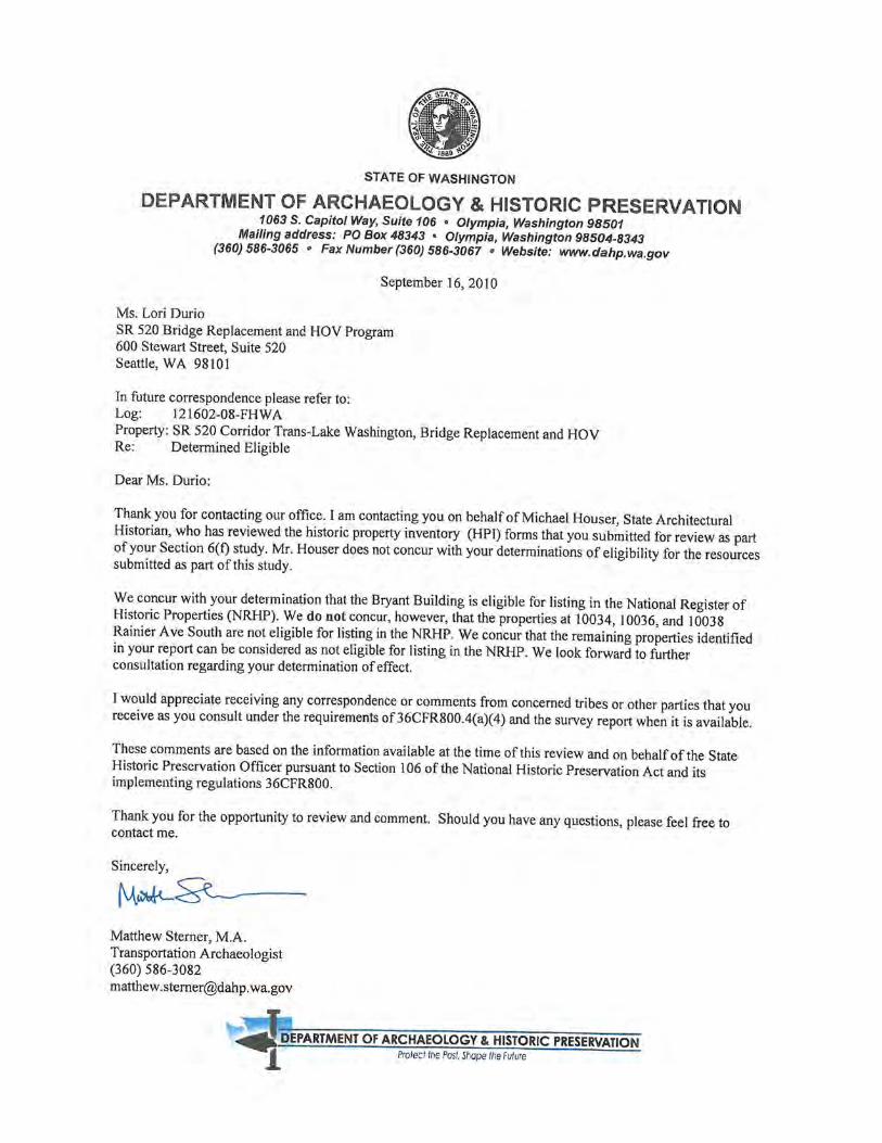
Log: 121602-08-FHWA
Property: SR 520 Corridor Trans-Lake Washington, Bridge Replacement and HOV
Re: Archaeology - APE Concur
Dear Mr. Bartoy:
We have reviewed the materials forwarded to our office for the above referenced project. Thank you for
your description of the revised area of potential effect (APE) that now incorporated property at the Ports
of Olympia and Tacoma. We concur with the definition of the revised APE. Since there are no
accompanying construction drawings, we presume that the APE boundaries reflect the maximum
footprint of the proposed construction.
We look forward to the results of your cultural resources survey efforts, your consultation with the
concerned tribes, and receiving the survey report. We would appreciate receiving any correspondence or
comments from concerned tribes or other parties that you receive as you consult under the requirements
of 36CFR800.4(a)(4) and the survey report when it is available.
These comments are based on the information available at the time of this review and on behalf of the
State Historic Preservation Officer in conformance with Section 106 of the National Historic Preservation
Act and its implementing regulations 36CFR800. Should additional information become available, our
assessment may be revised.
Please note that DAHP requires that all historic property inventory and archaeological site forms be
provided to our office electronically. If you have not registered for a copy of the database, please log onto
our website at www.dahp.wa.gov and go to the Survey/Inventory page for more information and a
registration form. To assist you in conducting a survey, DAHP has developed a set of cultural resource
reporting guidelines. You can obtain a copy of these guidelines from our website. Finally, please note that
effective Nov. 2, 2009, DAHP requires that all cultural resource reports be submitted in PDF format on a
labeled CD along with an unbound paper copy. For further information please go to
http://www.dahp.wa.gov/documents/CR_ReportPDF_Requirement.pdf.
Thank you for the opportunity to review and comment. If you have any questions, please feel free to
contact me.
Sincerely,
Matthew Sterner, M.A.
Transportation Archaeologist
(360) 586-3082

Copies of the following letter were sent to the following individuals:
Date Subject From To Corresp. Ref. No.
8/18/2010 SR 520 Bridge Replacement and HOV Project, Seattle, King County, DOEs for Potential Section 6(f) Replacement Properties
Lori Durio SR 520 Cultural Resources Program Lead WSDOT
Allyson Brooks Department of Archaeology and Historic Preservation 1063 S Capitol Way, Suite 106 Olympia, WA 98504-8343
LTR #1584

Attachment - CD-ROM with Database Files for Historic Property Inventory Forms and Cultural Resources Report for Section 6(f) Environmental Evaluation
Cc: Matthew Sterner, DAHP, w/o attachments
Randy Everett, Federal Highway Administration, w/o attachments Allison Hanson, WSDOT, w/o attachments
Kevin Bartoy, WSDOT, w/o attachments Scott Williams, WSDOT, w/o attachments

Copies of the following letter were sent to the following individuals:
Date Subject From To Corresp. Ref. No.
8/19/2010 SR 520 Bridge Replacement and HOV Project, Seattle, King County, DOEs for Potential Haul Route Properties
Lori Durio SR 520 Cultural Resources Program Lead WSDOT
Allyson Brooks Department of Archaeology and Historic Preservation 1063 S Capitol Way, Suite 106 Olympia, WA 98504-8343
None


Copies of the following letter were sent to the following individuals:
Date Subject From To Corresp. Ref. No.
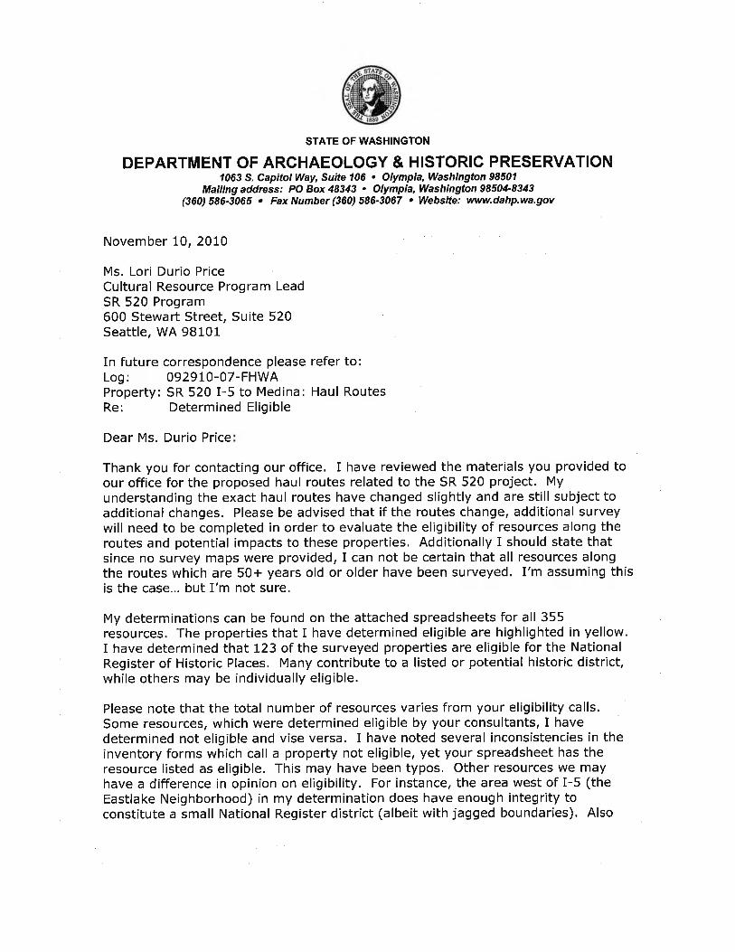
9/20/2010 SR 520 Bridge Replacement and HOV Project, Seattle, King County, Request for Concurrence with Eligibility Determination for Foster Island Traditional Cultural Property (TCP)
Kevin Bartoy Cultural Resources Specialist WSDOT
Allyson Brooks Department of Archaeology and Historic Preservation 1063 S Capitol Way, Suite 106 Olympia, WA 98504-8343
None


Advisory Council on Historic Preservation Consultation


National Parks Service Consultation


Consulting Party Consultation

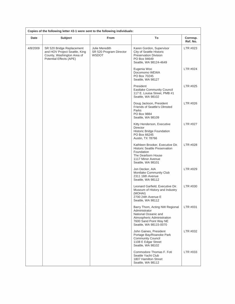
Copies of the following letter #2-1 were sent to the following individuals:
Date Subject From To Corresp. Ref. No.
4/8/2009 SR 520 Bridge Replacement and HOV Project Seattle, King County, Washington Area of Potential Effects (APE)
Julie Meredith SR 520 Program Director WSDOT
Karen Gordon, Supervisor City of Seattle Historic Preservation Division PO Box 94649 Seattle, WA 98124-4649
LTR #023
Eugenia Woo Docomomo WEWA PO Box 70245 Seattle, WA 98127
LTR #024
President Eastlake Community Council 117 E. Louisa Street, PMB #1 Seattle, WA 98102
LTR #025
Doug Jackson, President Friends of Seattle’s Olmsted Parks PO Box 9884 Seattle, WA 98109
LTR #026
Kitty Henderson, Executive Director Historic Bridge Foundation PO Box 66245 Austin, TX 78766
LTR #027
Kathleen Brooker, Executive Dir. Historic Seattle Preservation Foundation The Dearborn House 1117 Minor Avenue Seattle, WA 98101
LTR #028
Jon Decker, AIA Montlake Community Club 2311 16th Avenue Seattle, WA 98112
LTR #029
Leonard Garfield, Executive Dir. Museum of History and Industry (MOHAI) 2700 24th Avenue E Seattle, WA 98112
LTR #030
Barry Thom, Acting NW Regional Administrator National Oceanic and Atmospheric Administration 7600 Sand Point Way NE Seattle, WA 98115-0070
LTR #031
John Gaines, President Portage Bay/Roanoke Park Community Council 1108 E Edgar Street Seattle, WA 98102
LTR #032
Commodore Thomas F. Foti Seattle Yacht Club 1807 Hamilton Street Seattle, WA 98112
LTR #033
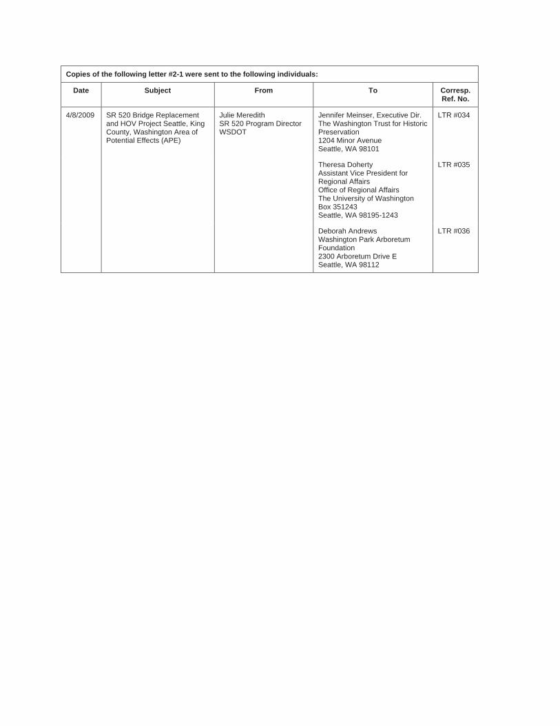
Copies of the following letter #2-1 were sent to the following individuals:
Date Subject From To Corresp. Ref. No.
4/8/2009 SR 520 Bridge Replacement and HOV Project Seattle, King County, Washington Area of Potential Effects (APE)
Julie Meredith SR 520 Program Director WSDOT
Jennifer Meinser, Executive Dir. The Washington Trust for Historic Preservation1204 Minor Avenue Seattle, WA 98101
LTR #034
Theresa Doherty Assistant Vice President for Regional Affairs Office of Regional Affairs The University of Washington Box 351243 Seattle, WA 98195-1243
LTR #035
Deborah Andrews Washington Park Arboretum Foundation 2300 Arboretum Drive E Seattle, WA 98112
LTR #036
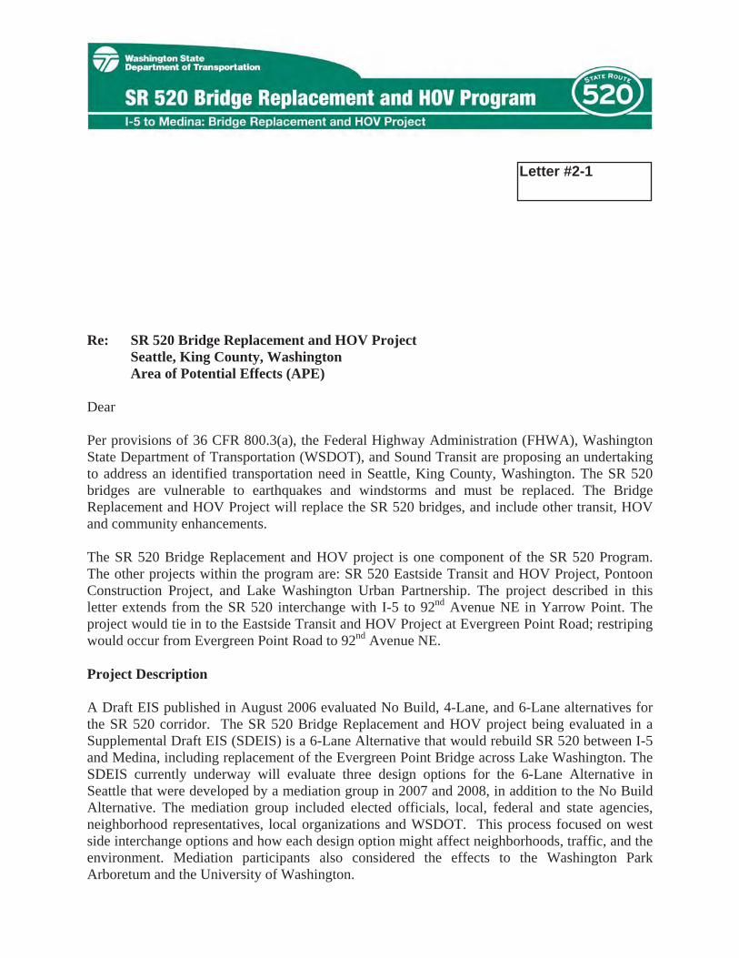
April 8, 2009 LTR #023
Karen Gordon, Supervisor City of Seattle Historic Preservation Division PO Box 94649 Seattle, WA 98124-4649
Re: SR 520 Bridge Replacement and HOV Project Seattle, King County, Washington
Area of Potential Effects (APE)
Dear Ms. Gordon:
Per provisions of 36 CFR 800.3(a), the Federal Highway Administration (FHWA), Washington State Department of Transportation (WSDOT), and Sound Transit are proposing an undertaking to address an identified transportation need in Seattle, King County, Washington. The SR 520 bridges are vulnerable to earthquakes and windstorms and must be replaced. The Bridge Replacement and HOV Project will replace the SR 520 bridges, and include other transit, HOV and community enhancements.
The SR 520 Bridge Replacement and HOV project is one component of the SR 520 Program. The other projects within the program are: SR 520 Eastside Transit and HOV Project, Pontoon Construction Project, and Lake Washington Urban Partnership. The project described in this letter extends from the SR 520 interchange with I-5 to 92nd Avenue NE in Yarrow Point. The project would tie in to the Eastside Transit and HOV Project at Evergreen Point Road; restriping would occur from Evergreen Point Road to 92nd Avenue NE.
Project Description
A Draft EIS published in August 2006 evaluated No Build, 4-Lane, and 6-Lane alternatives for the SR 520 corridor. The SR 520 Bridge Replacement and HOV project being evaluated in a Supplemental Draft EIS (SDEIS) is a 6-Lane Alternative that would rebuild SR 520 between I-5 and Medina, including replacement of the Evergreen Point Bridge across Lake Washington. The SDEIS currently underway will evaluate three design options for the 6-Lane Alternative in Seattle that were developed by a mediation group in 2007 and 2008, in addition to the No Build Alternative. The mediation group included elected officials, local, federal and state agencies, neighborhood representatives, local organizations and WSDOT. This process focused on west side interchange options and how each design option might affect neighborhoods, traffic, and the environment. Mediation participants also considered the effects to the Washington Park Arboretum and the University of Washington.
Letter #2-1
SR 520 Bridge Replacement and HOV Project APE April 8, 2009 Page 2
The mediation group developed three designs that were included in their 2008 project impact plan and WSDOT will further analyze all three in a NEPA Supplemental Draft EIS consistent with the WSDOT environmental process. The most significant differences are located in the vicinity of the Montlake neighborhood, and figures of the there options in this area are included in Appendix A of this submission. Appendix A also includes a schematic vicinity map. The three designs are:
� Option A - Most similar to today's configuration, with the addition of a second Montlake drawbridge over the Montlake Cut (Option A figure).
� Option K - Includes a tunnel under the Montlake Cut and a single point urban interchange below the SR 520 roadway (Option K figure).
� Option L - Includes a diagonal drawbridge over the Montlake Cut and a single point urban interchange above the SR 520 roadway (Option L figure).
Elements common to each option include:
� Two general-purpose lanes and one HOV lane in each direction (6-Lanes between I-5 and Medina).
� A bicycle and pedestrian path on the north side of SR 520.� A reversible direct HOV access ramp at the I-5/SR 520 connection. � Variable speed signs.� Lids at I-5, 10th Avenue E and Delmar Drive E
More details about each design option are available on the Program’s webpage: http://www.wsdot.wa.gov/Projects/SR520Bridge/brhpdesign.htm
Area of Potential Effects (APE) Pursuant to compliance with Section 106 of the National Historic Preservation Act (NHPA), we are consulting with you about the SR 520 Bridge Replacement and HOV Project. Enclosed (Appendix B) please find maps that illustrate the proposed APE for this project. The proposed APE includes all known areas of impact for all three (3) design options, which includes bridges, tunnels, roadway widening, several intersection improvements that include roadway widening, lids, and ADA-approved pedestrian walkways and upgrades, and known staging, temporary storage, and storm water management facilities. If there are any changes to the project, we will notify your office and provide additional information, including revised APE maps.
Built Environment
The APE for this project includes one parcel on either side of all areas of impact and ground disturbance. This approach is consistent with the APE determination for the former SR 520 project, with which your office concurred in 2005. For areas where only restriping will occur, such as on parts of Interstate-5, we are only including the highway right-of-way. The APE will account both for direct and indirect effects to historic properties. Direct effects may include demolition and alteration to historic properties, while potential indirect effects can be both during construction and subsequent operations, caused by noise, dust and dirt, vibration, change of setting, or other factors. All historic buildings, structures, sites, objects, and districts constructed prior to 1971 will be evaluated and documented. Further, based on our ongoing consultation with
SR 520 Bridge Replacement and HOV Project APE April 8, 2009 Page 3
your office, we have included the Washington Park Arboretum in the APE, and will determine eligibility and project effects, both positive and negative, as part of our evaluation
Electronic copies of Historic Property Inventory Database forms will be prepared for all properties that have not been surveyed within the last five years. Any properties surveyed within the last five years will be checked in the field to verify condition and integrity. Database inventory forms will be updated as necessary.
Archaeological Resources
Archaeological sites could be disturbed directly or destroyed by the project within the portion of the APE where construction activities will occur. Therefore, WSDOT has delineated a limits-of-construction (combined-option) to consider potential direct effects to archaeological historic properties. WSDOT plans to continue archaeological investigations to examine all areas either not included in the APE defined for the Draft EIS (2006), or purposefully not included at that time pending more detailed design plans that specifically identified ground disturbance locations (Foster Island). WSDOT intends to use background research, ethnographic study, field investigations, and evaluation of the project area’s geomorphology over time to identify archaeological historic properties and to assess the probability of encountering subsurface archaeological remains within the limits of construction. If encountered, archaeological sites will be recorded on DAHP archaeological site inventory forms.
Much of the construction portion of the APE was subjected to subsurface investigations during the Draft EIS process. Only one archaeological site, the Miller Street Landfill (45KI760), was identified. Foster Island is known to have been a burial ground of local Lakes Duwamish Indians, and has been identified as a culturally sensitive landform. WSDOT plans to use geophysical remote sensing, possibly other sophisticated techniques, and traditional archaeological investigations to identify potential burials on the Island (if present) in order to avoid or greatly minimize disturbance to them.
The archaeological portion of the APE also includes a vertical element in order to consider all potential effects from ground disturbance. The vertical APE is defined as either the full vertical limit of proposed construction, or the depth to consolidated glacial sediments, whichever is shallower. The latter part of the definition assumes that glacial sediments either pre-date all human occupation in the Puget Sound region, or would have been deposited after ice sheets scoured the landform and removed any physical evidence of pre-glacial human occupation.
Other Consulting Parties Per 36 CFR 800.2(c)(2), WSDOT and FHWA presently are consulting with five Native American tribes, including the Muckleshoot Indian Tribe, the Suquamish Tribe, the Snoqualmie Tribe, the Tulalip Tribes, and the Yakama Nation. We also are consulting with the non-federally recognized Duwamish Tribal Community. All tribes and tribal organizations, except for the Yakama Nation, have shown strong interest in the project and the SR 520 Program, and are actively involved with consultation.
Because of the size and scope of this project, WSDOT contacted several groups to participate as Section 106 consulting parties for this project, per provisions in 36 CFR 800.2(c)(5)(d)(i). In a letter dated March 2, 2009, the SR 520 project team invited several agencies, groups, and
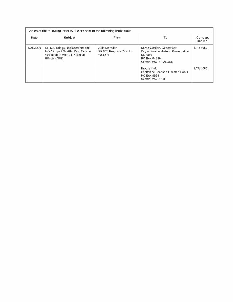
Copies of the following letter #2-2 were sent to the following individuals:
Date Subject From To Corresp. Ref. No.
4/21/2009 SR 520 Bridge Replacement and HOV Project Seattle, King County, Washington Area of Potential Effects (APE)
Julie Meredith SR 520 Program Director WSDOT
Karen Gordon, Supervisor City of Seattle Historic Preservation DivisionPO Box 94649 Seattle, WA 98124-4649
LTR #056
Brooks Kolb Friends of Seattle’s Olmsted Parks PO Box 9884 Seattle, WA 98109
LTR #057


April 21, 2009
LTR # 056
Karen Gordon, Supervisor and Historic Preservation Officer City of Seattle Historic Preservation Division (DON) PO Box 94649 Seattle, WA 98124-4649
Re: SR 520 Bridge Replacement and HOV Project Seattle, King County, Washington
Area of Potential Effects (APE)
Dear Ms. Brooks:
Per provisions of 36 CFR 800.3(a), the Federal Highway Administration (FHWA), Washington State Department of Transportation (WSDOT), and Sound Transit are proposing an undertaking to address an identified transportation need in Seattle, King County, Washington. The SR 520 bridges are vulnerable to earthquakes and windstorms and must be replaced. The Bridge Replacement and HOV Project will replace the SR 520 bridges, and include other transit, HOV and community enhancements.
The SR 520 Bridge Replacement and HOV project is one component of the SR 520 Program. The other projects within the program are: SR 520 Eastside Transit and HOV Project, Pontoon Construction Project, and Lake Washington Urban Partnership. The project described in this letter extends from the SR 520 interchange with I-5 to 92nd Avenue NE in Yarrow Point. The project would tie in to the Eastside Transit and HOV Project at Evergreen Point Road; restriping would occur from Evergreen Point Road to 92nd Avenue NE.
Project Description
A Draft EIS published in August 2006 evaluated No Build, 4-Lane, and 6-Lane alternatives for the SR 520 corridor. The SR 520 Bridge Replacement and HOV project being evaluated in a Supplemental Draft EIS (SDEIS) is a 6-Lane Alternative that would rebuild SR 520 between I-5 and Medina, including replacement of the Evergreen Point Bridge across Lake Washington. The SDEIS currently underway will evaluate three design options for the 6-Lane Alternative in Seattle that were developed by a mediation group in 2007 and 2008, in addition to the No Build Alternative. The mediation group included elected officials, local, federal and state agencies, neighborhood representatives, local organizations and WSDOT. This process focused on west side interchange options and how each design option might affect neighborhoods, traffic, and the environment. Mediation participants also considered the effects to the Washington Park Arboretum and the University of Washington.
Letter #2-2

SR 520 Bridge Replacement and HOV Project APE April 21, 2009 Page 2
The mediation group developed three designs that were included in their 2008 project impact plan and WSDOT will further analyze all three in a NEPA Supplemental Draft EIS consistent with the WSDOT environmental process. The most significant differences are located in the vicinity of the Montlake neighborhood, and figures of the there options in this area are included in Appendix A of this submission. Appendix A also includes a schematic vicinity map. The three designs are:
� Option A - Most similar to today's configuration, with the addition of a second Montlake drawbridge over the Montlake Cut (Option A figure).
� Option K - Includes a tunnel under the Montlake Cut and a single point urban interchange below the SR 520 roadway (Option K figure).
� Option L - Includes a diagonal drawbridge over the Montlake Cut and a single point urban interchange above the SR 520 roadway (Option L figure).
Elements common to each option include:
� Two general-purpose lanes and one HOV lane in each direction (6-Lanes between I-5 and Medina).
� A bicycle and pedestrian path on the north side of SR 520.� A reversible direct HOV access ramp at the I-5/SR 520 connection. � Variable speed signs.� Lids at I-5, 10th Avenue E and Delmar Drive E
More details about each design option are available on the Program’s webpage: http://www.wsdot.wa.gov/Projects/SR520Bridge/brhpdesign.htm
Area of Potential Effects (APE) Pursuant to compliance with Section 106 of the National Historic Preservation Act (NHPA), we are consulting with you about the SR 520 Bridge Replacement and HOV Project. Enclosed (Appendix B) please find maps that illustrate the proposed APE for this project. The proposed APE includes all known areas of impact for all three (3) design options, which includes bridges, tunnels, roadway widening, several intersection improvements that include roadway widening, lids, and ADA-approved pedestrian walkways and upgrades, and known staging, temporary storage, and storm water management facilities. If there are any changes to the project, we will notify your office and provide additional information, including revised APE maps.
Built Environment
The APE for this project includes one parcel on either side of all areas of impact and ground disturbance. This approach is consistent with the APE determination for the former SR 520 project, with which your office concurred in 2005. For areas where only restriping will occur, such as on parts of Interstate-5, we are only including the highway right-of-way. The APE will account both for direct and indirect effects to historic properties. Direct effects may include demolition and alteration to historic properties, while potential indirect effects can be both during construction and subsequent operations, caused by noise, dust and dirt, vibration, change of setting, or other factors. All historic buildings, structures, sites, objects, and districts constructed prior to 1971 will be evaluated and documented. Further, based on our ongoing consultation with your office, we have included the
SR 520 Bridge Replacement and HOV Project APE April 21, 2009 Page 3
Washington Park Arboretum in the APE, and will determine eligibility and project effects, both positive and negative, as part of our evaluation
Electronic copies of Historic Property Inventory Database forms will be prepared for all properties that have not been surveyed within the last five years. Any properties surveyed within the last five years will be checked in the field to verify condition and integrity. Database inventory forms will be updated as necessary.
Archaeological Resources
Archaeological sites could be disturbed directly or destroyed by the project within the portion of the APE where construction activities will occur. Therefore, WSDOT has delineated a limits-of-construction (combined-option) to consider potential direct effects to archaeological historic properties. WSDOT plans to continue archaeological investigations to examine all areas either not included in the APE defined for the Draft EIS (2006), or purposefully not included at that time pending more detailed design plans that specifically identified ground disturbance locations (Foster Island). WSDOT intends to use background research, ethnographic study, field investigations, and evaluation of the project area’s geomorphology over time to identify archaeological historic properties and to assess the probability of encountering subsurface archaeological remains within the limits of construction. If encountered, archaeological sites will be recorded on DAHP archaeological site inventory forms.
Much of the construction portion of the APE was subjected to subsurface investigations during the Draft EIS process. Only one archaeological site, the Miller Street Landfill (45KI760), was identified. Foster Island is known to have been a burial ground of local Lakes Duwamish Indians, and has been identified as a culturally sensitive landform. WSDOT plans to use geophysical remote sensing, possibly other sophisticated techniques, and traditional archaeological investigations to identify potential burials on the Island (if present) in order to avoid or greatly minimize disturbance to them.
The archaeological portion of the APE also includes a vertical element in order to consider all potential effects from ground disturbance. The vertical APE is defined as either the full vertical limit of proposed construction, or the depth to consolidated glacial sediments, whichever is shallower. The latter part of the definition assumes that glacial sediments either pre-date all human occupation in the Puget Sound region, or would have been deposited after ice sheets scoured the landform and removed any physical evidence of pre-glacial human occupation.
Other Consulting Parties Per 36 CFR 800.2(c)(2), WSDOT and FHWA presently are consulting with five Native American tribes, including the Muckleshoot Indian Tribe, the Suquamish Tribe, the Snoqualmie Tribe, the Tulalip Tribes, and the Yakama Nation. We also are consulting with the non-federally recognized Duwamish Tribal Community. All tribes and tribal organizations, except for the Yakama Nation, have shown strong interest in the project and the SR 520 Program, and are actively involved with consultation.
Because of the size and scope of this project, WSDOT contacted several groups to participate as Section 106 consulting parties for this project, per provisions in 36 CFR 800.2(c)(5)(d)(i). In a letter dated March 2, 2009, the SR 520 project team invited several agencies, groups, and organizations to
SR 520 Bridge Replacement and HOV Project APE April 21, 2009 Page 4
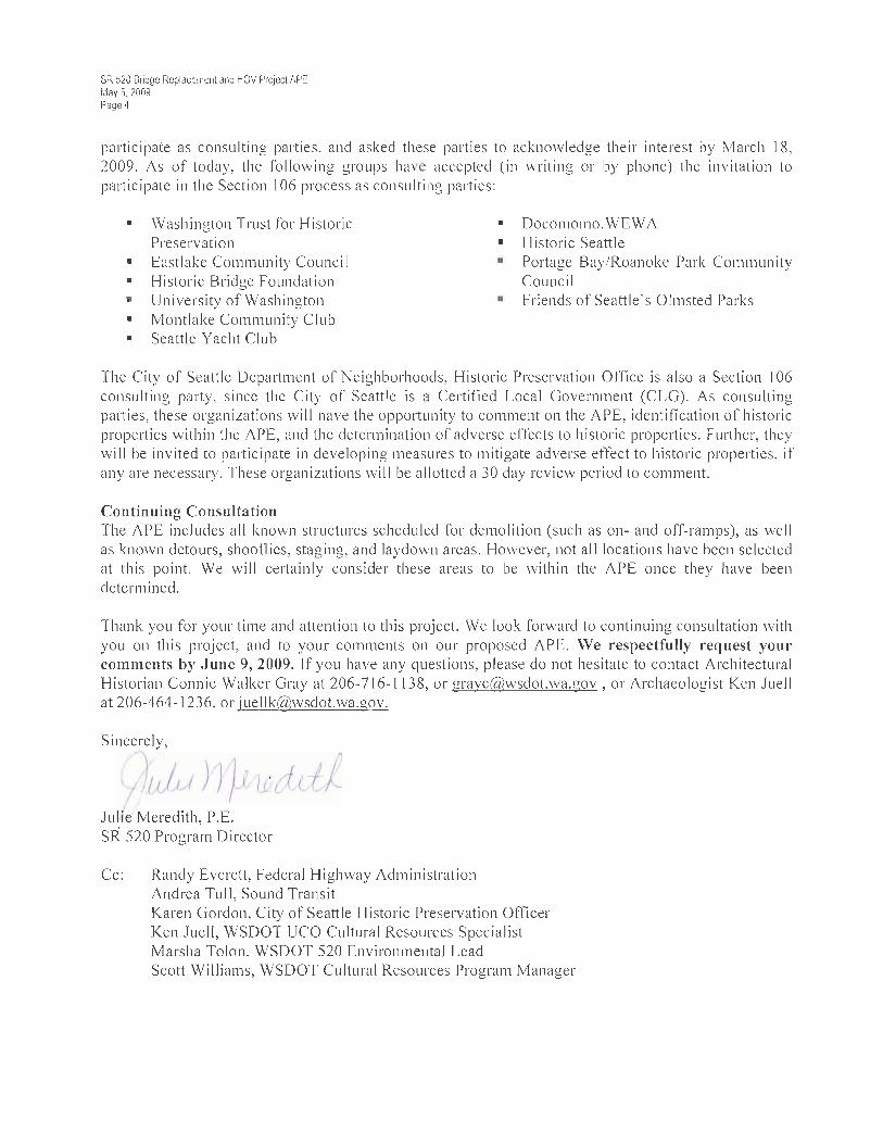
participate as consulting parties, and asked these parties to acknowledge their interest by March 18, 2009. As of today, the following groups have accepted (in writing or by phone) the invitation to participate in the Section 106 process as consulting parties:
� Washington Trust for Historic Preservation
� Eastlake Community Council � Historic Bridge Foundation� University of Washington � Montlake Community Club � Seattle Yacht Club
� Docomomo.WEWA � Historic Seattle� Portage Bay/Roanoke Park Community
Council� Friends of Seattle’s Olmsted Parks
The City of Seattle Department of Neighborhoods, Historic Preservation Office is also a Section 106 consulting party, since the City of Seattle is a Certified Local Government (CLG). As consulting parties, these organizations will have the opportunity to comment on the APE, identification of historic properties within the APE, and the determination of adverse effects to historic properties. Further, they will be invited to participate in developing measures to mitigate adverse effect to historic properties, if any are necessary. These organizations will be allotted a 30 day review period to comment.
Continuing Consultation The APE includes all known structures scheduled for demolition (such as on- and off-ramps), as well as known detours, shooflies, staging, and laydown areas. However, not all locations have been selected at this point. We will certainly consider these areas to be within the APE once they have been determined.
Thank you for your time and attention to this project. We look forward to continuing consultation with you on this project, and to your comments on our proposed APE. We respectfully request your comments by May 20, 2009. If you have any questions, please do not hesitate to contact Architectural Historian Connie Walker Gray at 206-716-1138, or [email protected] , or Archaeologist Ken Juell at 206-464-1236, or [email protected].
Sincerely,
Julie Meredith, P.E. SR 520 Program Director
Cc: Randy Everett, Federal Highway Administration Andrea Tull, Sound Transit Karen Gordon, City of Seattle Historic Preservation Officer Ken Juell, WSDOT UCO Cultural Resources Specialist Marsha Tolon, WSDOT 520 Environmental Lead
Scott Williams, WSDOT Cultural Resources Program Manager
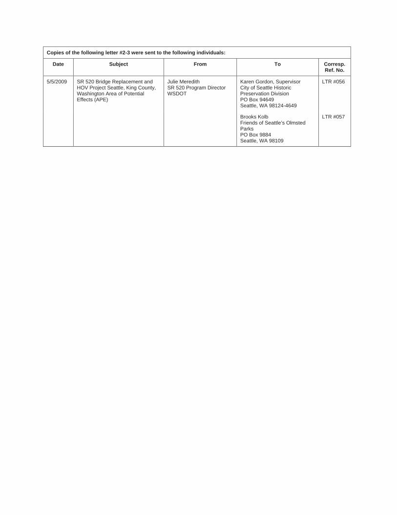
Copies of the following letter #2-3 were sent to the following individuals:
Date Subject From To Corresp. Ref. No.
5/5/2009 SR 520 Bridge Replacement and HOV Project Seattle, King County, Washington Area of Potential Effects (APE)
Julie Meredith SR 520 Program Director WSDOT
Karen Gordon, Supervisor City of Seattle Historic Preservation Division PO Box 94649 Seattle, WA 98124-4649
LTR #056
Brooks Kolb Friends of Seattle’s Olmsted Parks PO Box 9884 Seattle, WA 98109
LTR #057

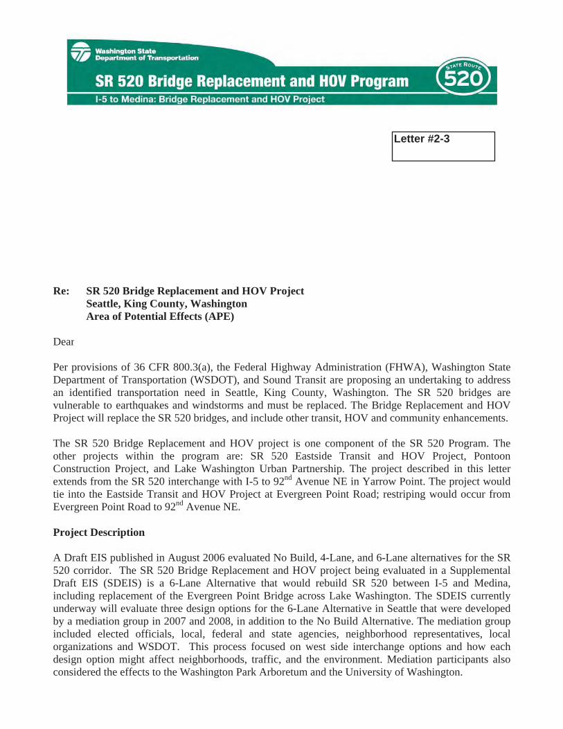
May 5, 2009
LTR # 056
Karen Gordon, Supervisor and Historic Preservation Officer City of Seattle Historic Preservation Division (DON) PO Box 94649 Seattle, WA 98124-4649
Re: SR 520 Bridge Replacement and HOV Project Seattle, King County, Washington
Area of Potential Effects (APE)
Dear Ms. Gordon:
Per provisions of 36 CFR 800.3(a), the Federal Highway Administration (FHWA), Washington State Department of Transportation (WSDOT), and Sound Transit are proposing an undertaking to address an identified transportation need in Seattle, King County, Washington. The SR 520 bridges are vulnerable to earthquakes and windstorms and must be replaced. The Bridge Replacement and HOV Project will replace the SR 520 bridges, and include other transit, HOV and community enhancements.
The SR 520 Bridge Replacement and HOV project is one component of the SR 520 Program. The other projects within the program are: SR 520 Eastside Transit and HOV Project, Pontoon Construction Project, and Lake Washington Urban Partnership. The project described in this letter extends from the SR 520 interchange with I-5 to 92nd Avenue NE in Yarrow Point. The project would tie into the Eastside Transit and HOV Project at Evergreen Point Road; restriping would occur from Evergreen Point Road to 92nd Avenue NE.
Project Description
A Draft EIS published in August 2006 evaluated No Build, 4-Lane, and 6-Lane alternatives for the SR 520 corridor. The SR 520 Bridge Replacement and HOV project being evaluated in a Supplemental Draft EIS (SDEIS) is a 6-Lane Alternative that would rebuild SR 520 between I-5 and Medina, including replacement of the Evergreen Point Bridge across Lake Washington. The SDEIS currently underway will evaluate three design options for the 6-Lane Alternative in Seattle that were developed by a mediation group in 2007 and 2008, in addition to the No Build Alternative. The mediation group included elected officials, local, federal and state agencies, neighborhood representatives, local organizations and WSDOT. This process focused on west side interchange options and how each design option might affect neighborhoods, traffic, and the environment. Mediation participants also considered the effects to the Washington Park Arboretum and the University of Washington.
Letter #2-3
SR 520 Bridge Replacement and HOV Project APE May 5, 2009 Page 2
The mediation group developed three designs that were included in their 2008 project impact plan and WSDOT will further analyze all three in a NEPA Supplemental Draft EIS consistent with the WSDOT environmental process. The most significant differences are located in the vicinity of the Montlake neighborhood, and figures of the three (3) options in this area are included in Appendix A of this submission. Appendix A also includes a schematic vicinity map. The three designs are:
� Option A - Most similar to today's configuration, with the addition of a second Montlake drawbridge over the Montlake Cut (Option A figure).
� Option K - Includes a tunnel under the Montlake Cut and a single point urban interchange below the SR 520 roadway (Option K figure).
� Option L - Includes a diagonal drawbridge over the Montlake Cut and a single point urban interchange above the SR 520 roadway (Option L figure).
Elements common to each option include:
� Two general-purpose lanes and one HOV lane in each direction (6-Lanes between I-5 and Medina).
� A bicycle and pedestrian path on the north side of SR 520.� A reversible direct HOV access ramp at the I-5/SR 520 connection. � Variable speed signs.� Lids at I-5, 10th Avenue E and Delmar Drive E
More details about each design option are available on the Program’s webpage: http://www.wsdot.wa.gov/Projects/SR520Bridge/brhpdesign.htm
Area of Potential Effects (APE) Pursuant to compliance with Section 106 of the National Historic Preservation Act (NHPA), we are consulting with you about the SR 520 Bridge Replacement and HOV Project. Enclosed (Appendix B) please find maps that illustrate the proposed APE for this project. The proposed APE includes all known areas of impact for all three (3) design options, which includes bridges, tunnels, roadway widening, several intersection improvements that include roadway widening, lids, and ADA-approved pedestrian walkways and upgrades, and known staging, temporary storage, and storm water management facilities. If there are any changes to the project, we will notify your office and provide additional information, including revised APE maps.
Built Environment
The APE for this project includes one parcel on either side of all areas of impact and ground disturbance. This approach is consistent with the APE determination for the former SR 520 project. For areas where only restriping will occur, such as on parts of Interstate-5, we are only including the highway right-of-way. The APE will account both for direct and indirect effects to historic properties. Direct effects may include demolition and alteration to historic properties, while potential indirect effects can be both during construction and subsequent operations, caused by noise, dust and dirt, vibration, change of setting, or other factors. All historic buildings, structures, sites, objects, and districts constructed prior to 1971 will be evaluated and documented. Further, based on our ongoing consultation with the Seattle Historic Preservation Office, we have included the Washington Park
SR 520 Bridge Replacement and HOV Project APE May 5, 2009 Page 3
Arboretum in the APE, and will determine eligibility and project effects, both positive and negative, as part of our evaluation
Electronic copies of Historic Property Inventory Database forms will be prepared for all properties that have not been surveyed within the last five years. Any properties surveyed within the last five years will be checked in the field to verify condition and integrity. Database inventory forms will be updated as necessary.
Archaeological Resources
Archaeological sites could be disturbed directly or destroyed by the project within the portion of the APE where construction activities will occur. Therefore, WSDOT has delineated a limits-of-construction (combined-option) to consider potential direct effects to archaeological historic properties. WSDOT plans to continue archaeological investigations to examine all areas either not included in the APE defined for the Draft EIS (2006), or purposefully not included at that time pending more detailed design plans that specifically identified ground disturbance locations (Foster Island). WSDOT intends to use background research, ethnographic study, field investigations, and evaluation of the project area’s geomorphology over time to identify archaeological historic properties and to assess the probability of encountering subsurface archaeological remains within the limits of construction. If encountered, archaeological sites will be recorded on DAHP archaeological site inventory forms.
Much of the construction portion of the APE was subjected to subsurface investigations during the Draft EIS process. Only one archaeological site, the Miller Street Landfill (45KI760), was identified. Foster Island is known to have been a burial ground of local Lakes Duwamish Indians, and has been identified as a culturally sensitive landform. WSDOT plans to use geophysical remote sensing, possibly other sophisticated techniques, and traditional archaeological investigations to identify potential burials on the Island (if present) in order to avoid or greatly minimize disturbance to them.
The archaeological portion of the APE also includes a vertical element in order to consider all potential effects from ground disturbance. The vertical APE is defined as either the full vertical limit of proposed construction, or the depth to consolidated glacial sediments, whichever is shallower. The latter part of the definition assumes that glacial sediments either pre-date all human occupation in the Puget Sound region, or would have been deposited after ice sheets scoured the landform and removed any physical evidence of pre-glacial human occupation.
Other Consulting Parties Per 36 CFR 800.2(c)(2), WSDOT and FHWA presently are consulting with five Native American tribes, including the Muckleshoot Indian Tribe, the Suquamish Tribe, the Snoqualmie Tribe, the Tulalip Tribes, and the Yakama Nation. We also are consulting with the non-federally recognized Duwamish Tribal Community. All tribes and tribal organizations, except for the Yakama Nation, have shown strong interest in the project and the SR 520 Program, and are actively involved with consultation.
Because of the size and scope of this project, WSDOT contacted several groups to participate as Section 106 consulting parties for this project, per provisions in 36 CFR 800.2(c)(5)(d)(i). In a letter dated March 2, 2009, the SR 520 project team invited several agencies, groups, and organizations to
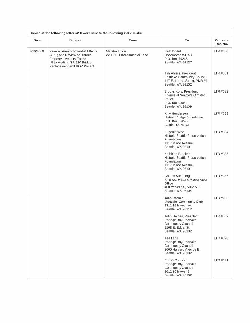
Copies of the following letter #2-8 were sent to the following individuals:
Date Subject From To Corresp. Ref. No.
7/16/2009 Revised Area of Potential Effects (APE) and Review of Historic Property Inventory Forms I-5 to Medina: SR 520 Bridge Replacement and HOV Project
Marsha Tolon WSDOT Environmental Lead
Beth Dodrill Docomomo WEWA P.O. Box 70245 Seattle, WA 98127
LTR #080
Tim Ahlers, President Eastlake Community Council 117 E. Louisa Street, PMB #1 Seattle, WA 98102
LTR #081
Brooks Kolb, President Friends of Seattle’s Olmsted Parks P.O. Box 9884 Seattle, WA 98109
LTR #082
Kitty Henderson Historic Bridge Foundation P.O. Box 66245 Austin, TX 78766
LTR #083
Eugenia Woo Historic Seattle Preservation Foundation 1117 Minor Avenue Seattle, WA 98101
LTR #084
Kathleen Brooker Historic Seattle Preservation Foundation 1117 Minor Avenue Seattle, WA 98101
LTR #085
Charlie Sundberg King Co. Historic Preservation Office400 Yesler St., Suite 510 Seattle, WA 98104
LTR #086
John Decker Montlake Community Club 2311 16th Avenue Seattle, WA 98112
LTR #088
John Gaines, President Portage Bay/Roanoke Community Council 1108 E. Edgar St. Seattle, WA 98102
LTR #089
Ted Lane Portage Bay/Roanoke Community Council 2600 Harvard Avenue E. Seattle, WA 98102
LTR #090
Erin O’Connor Portage Bay/Roanoke Community Council 2612 10th Ave. E Seattle, WA 98102
LTR #091
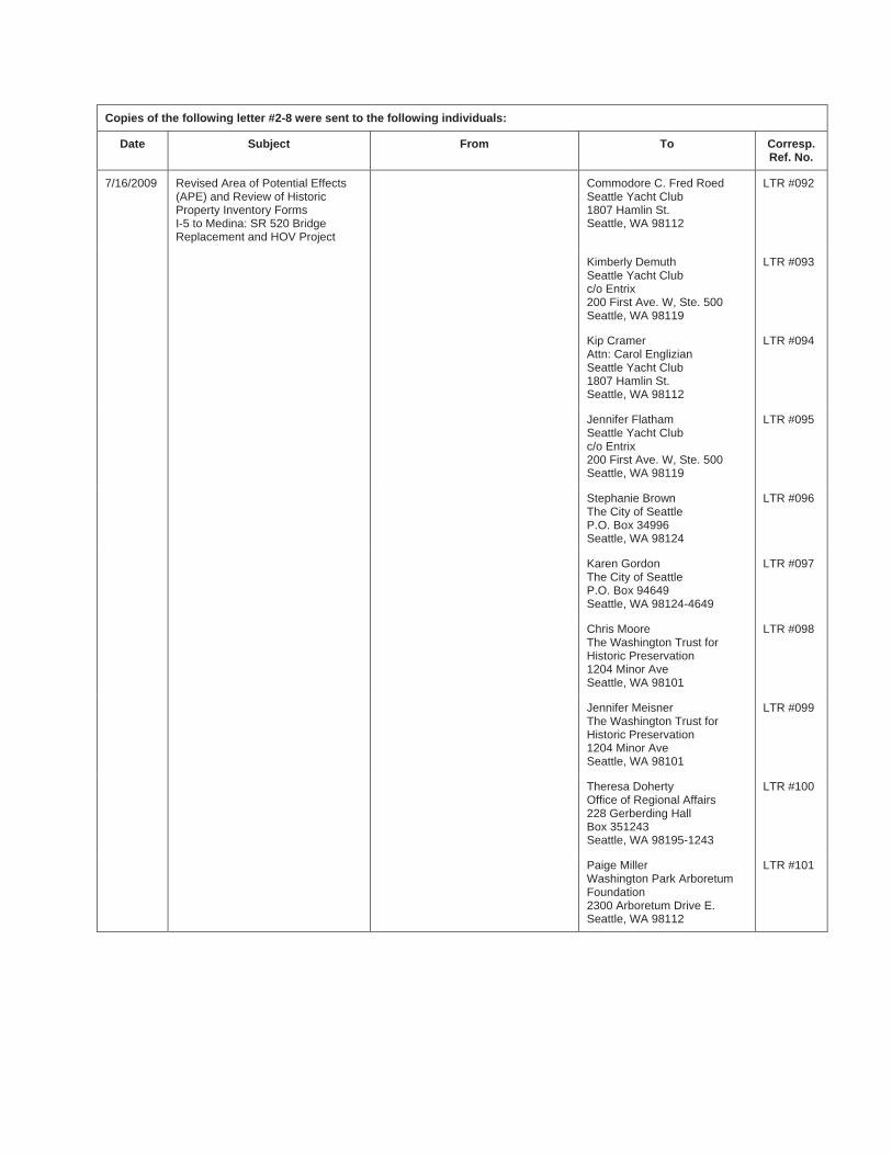
Copies of the following letter #2-8 were sent to the following individuals:
Date Subject From To Corresp. Ref. No.
7/16/2009 Revised Area of Potential Effects (APE) and Review of Historic Property Inventory Forms I-5 to Medina: SR 520 Bridge Replacement and HOV Project
Commodore C. Fred Roed Seattle Yacht Club 1807 Hamlin St. Seattle, WA 98112
LTR #092
Kimberly Demuth Seattle Yacht Club c/o Entrix 200 First Ave. W, Ste. 500 Seattle, WA 98119
LTR #093
Kip Cramer Attn: Carol Englizian Seattle Yacht Club 1807 Hamlin St. Seattle, WA 98112
LTR #094
Jennifer Flatham Seattle Yacht Club c/o Entrix 200 First Ave. W, Ste. 500 Seattle, WA 98119
LTR #095
Stephanie Brown The City of Seattle P.O. Box 34996 Seattle, WA 98124
LTR #096
Karen Gordon The City of Seattle P.O. Box 94649 Seattle, WA 98124-4649
LTR #097
Chris Moore The Washington Trust for Historic Preservation 1204 Minor Ave Seattle, WA 98101
LTR #098
Jennifer Meisner The Washington Trust for Historic Preservation 1204 Minor Ave Seattle, WA 98101
LTR #099
Theresa Doherty Office of Regional Affairs 228 Gerberding Hall Box 351243 Seattle, WA 98195-1243
LTR #100
Paige Miller Washington Park Arboretum Foundation 2300 Arboretum Drive E. Seattle, WA 98112
LTR #101
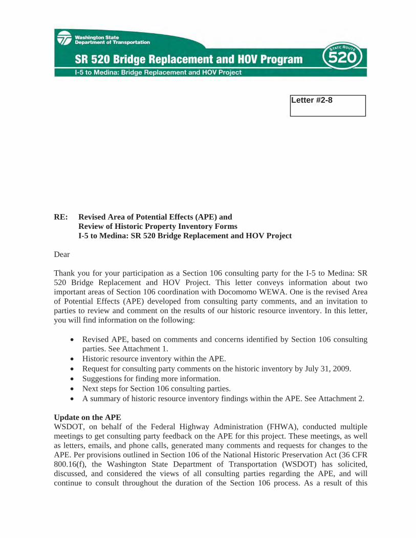
July 16, 2009
LTR # 080
Beth Dodrill Docomomo WEWA P.O. Box 70245 Seattle, WA 98127
RE: Revised Area of Potential Effects (APE) and Review of Historic Property Inventory Forms I-5 to Medina: SR 520 Bridge Replacement and HOV Project
Dear Ms. Dodrill:
Thank you for your participation as a Section 106 consulting party for the I-5 to Medina: SR 520 Bridge Replacement and HOV Project. This letter conveys information about two important areas of Section 106 coordination with Docomomo WEWA. One is the revised Area of Potential Effects (APE) developed from consulting party comments, and an invitation to parties to review and comment on the results of our historic resource inventory. In this letter, you will find information on the following:
� Revised APE, based on comments and concerns identified by Section 106 consulting parties. See Attachment 1.
� Historic resource inventory within the APE. � Request for consulting party comments on the historic inventory by July 31, 2009. � Suggestions for finding more information. � Next steps for Section 106 consulting parties. � A summary of historic resource inventory findings within the APE. See Attachment 2.
Update on the APE WSDOT, on behalf of the Federal Highway Administration (FHWA), conducted multiple meetings to get consulting party feedback on the APE for this project. These meetings, as well as letters, emails, and phone calls, generated many comments and requests for changes to the APE. Per provisions outlined in Section 106 of the National Historic Preservation Act (36 CFR 800.16(f), the Washington State Department of Transportation (WSDOT) has solicited, discussed, and considered the views of all consulting parties regarding the APE, and will continue to consult throughout the duration of the Section 106 process. As a result of this
Letter #2-8
SR 520 Bridge Replacement and HOV Project July 16, 2009 Page 2 of 3
consultation, WSDOT has adjusted the APE to accommodate many of the recommendations of the consulting parties. Comments on issues not directly related to the APE (such as potential adverse effects or mitigation) will be addressed later in the Section 106 process.
Attachment 1 of this letter includes the revised APE maps and WSDOT’s justification for why the APE was or was not altered. Again, we appreciate your participation in the Section 106 process, and your comments on the APE.
Historic Resource Inventory within the APE As part of the Section 106 process, we provide you the results of our historic resource inventory. WSDOT has evaluated every built environment resource constructed in or before 1971 within the revised APE. A professional architectural historian, who meets the Secretary of Interior Standards qualifications, has evaluated each property per the National Park Service guidelines for potential National Register of Historic Places eligibility. Each resource has been recorded in the Washington State Historic Property Inventory database administered by the Department of Archaeology and Historic Preservation.
The historic property evaluation is based on a “reconnaissance-level” survey, as required by the Department of Archaeology and Historic Preservation, and not every detail about each property is captured. Please review the Historic Property Inventory forms of interest, returning any comments on the forms to me by Friday, July 31, 2009, using the contact information at the end of this letter.
Comment Instructions To help in your review of the inventory information, please refer to Attachment 2: Summary of SR 520 Bridge Replacement and HOV Project Historic Resources Inventory Findings. A reference map is included with the CD containing the Historic Property Inventory forms in PDF format; no paper copies of the forms are available. Please focus your comments according to the two guidelines below:
1. Glaring errors and omissions which may result in a different determination of eligibility; and/or
2. Any information that increases our understanding of a property’s historic significance, and may lead to a different determination of eligibility for the National Register of Historic Places.
Need more information? For additional information on the historic property survey and inventory, you may refer to the following resources:
� Department of Archaeology and Historic Preservation overview of survey and inventory: http://www.dahp.wa.gov/pages/HistoricSites/Survey.htm

Attachment 1: Revised Area of Potential Effects
In May and June 2009, the Washington State Department of Transportation (WSDOT), on behalf of the Federal Highway Administration (FHWA), conducted multiple meetings to get consulting party feedback on the Area of Potential Effects (APE) for the SR 520 Bridge Replacement and HOV Project. These meetings, as well as letters, emails, and phone calls, generated many comments and requests for changes to the APE. Per provisions outlined in Section 106 of the National Historic Preservation Act (36 CFR 800.16(f)), WSDOT has solicited, discussed, and considered the views of all consulting parties regarding the APE, and will continue to consult throughout the duration of the Section 106 process. As a result of this consultation, WSDOT has adjusted the APE to accommodate many of the recommendations of the consulting parties.
Below is a summary of the comments and concerns raised by consulting parties about the APE, and WSDOT’s response. The revised APE maps (which include the location and NRHP-eligibility of resources within the APE) are located at the end of the summary.
Recommendation that WSDOT include the entire Roanoke Park Historic District within the APE.
WSDOT has expanded the APE to include the entire historic district within the APE.
Recommendation that WSDOT include Lake Washington Boulevard between East Madison Street and 32nd Avenue, as well as Boyer Avenue between 24th Avenue and Lake Washington Boulevard.
WSDOT does not plan to amend the APE to include these two areas. These areas already have traffic that lead to and from the Lake Washington Boulevard ramps. Compared to existing conditions, there is no potential for traffic to cause an adverse effect in these areas, which currently see heavy traffic volumes. Lake Washington Boulevard, Boyer Avenue, 24th Avenue East (north of Galer) and East Madison Street are all classified by the city of Seattle as arterials. Increased traffic has no potential to constitute an effect on historic properties that may be located on Lake Washington Boulevard between E. Madison Street and 32nd Avenue or Boyer Avenue between 24th Avenue and Lake Washington Boulevard.
SR 520 Bridge Replacement and HOV Project July 16, 2009 Attachment 1: Revised Area of Potential Effects Page 1 of 3
Recommendation that WSDOT expand the APE to include the Rainier Vista viewshed.
The southwestern-most portion of the Rainier Vista is included in the APE. However, the Rainier Vista was determined not eligible for listing in the National Register of Historic Places in 2003. Although we recognize it as part of the Alaska-Yukon-Pacific Exposition, the Rainier Vista is not a historic property as defined by Section 106 of the National Historic Preservation Act. Therefore, we will not adjust the APE to include the Rainier Vista “Fountain to Mountain” viewshed. Please note that the visual resources section of the project’s environmental impact statement will take into consideration the impact that the project will have on viewsheds and scenic features within the project area.
Recommendation that all construction staging areas be included in the APE.
All known staging areas are included within the APE; if additional staging areas are identified, the APE will be modified to account for the new staging areas.
Recommendation that WSDOT include all known haul routes within the APE.
WSDOT has adjusted the APE to include haul routes along non-arterial residential streets. This includes areas not yet within the APE, such as E. Shelby and E. Hamlin Streets, between Montlake Boulevard and McCurdy Park. However, the majority of haul routes are on streets that have been defined as arterials by the city of Seattle. This includes haul routes along 24th Avenue East, Montlake Boulevard, NE Pacific Street, Boyer Avenue East, and Harvard Avenue East.
Arterials have been identified by the city of Seattle in order to accommodate more traffic than local streets. Given the current baseline traffic conditions, temporary increases in truck traffic on arterials during construction would not have the potential to cause adverse effects to adjacent historic properties, if any exist.
The effects of construction truck trips on the local arterial system will be relatively minor for all options. With average construction activity, truck trips would range from 1-2 trips per hour under Option A and Option L, and 1-5 trips per hour under Option K. During peak construction periods, truck trips would range from 2-8 trips per hour under Option A, 2-20 trips per hour under Option K, and 2-12 trips per hour under Option L. The temporary nature of the increased traffic would not have the potential to cause a loss of integrity of the historic properties’ physical characteristics that convey their historic significance.
However, increased truck traffic on local (non-arterial) streets such as E. Shelby and E. Hamlin Streets between 24th Avenue East and McCurdy Park has the potential to cause alterations in the character or use of properties that may be eligible for listing in the National Register of Historic Places. Therefore, we are
SR 520 Bridge Replacement and HOV Project July 16, 2009 Attachment 1: Revised Area of Potential Effects Page 2 of 3
now including this area within the APE. Construction truck volumes would increase traffic approximately 10-40 percent on these streets.
WSDOT will be evaluating potential construction impacts from haul routes outside of the Section 106 framework during the NEPA process. If this analysis identifies potential impacts that would result in a loss of integrity to historic properties as defined by Section 106, the APE may be modified to take these impacts into account.
Recommendation that WSDOT include the entire area of Portage Bay (up to the University Bridge) and the Montlake Cut (to Webster Point), including the grounds just north of the Seattle Yacht Club clubhouse.
WSDOT will adjust the APE to include the entire navigable waterways of Portage Bay and the entire Montlake Cut, terminating at the eastern end of the Cut. The adjusted APE will not include additional shoreline docks, house boats, bridges, or other structures along the shores of Portage Bay, except for what was already included in the APE submitted in April 2009.
There is no potential to affect the character or use of historic properties as defined by Section 106 in the water east of the Montlake Cut out to Webster Point; therefore, that area is not included in the APE. Further, there is no potential to affect historic properties on or near the grounds north of the Seattle Yacht Club, so that area is also not included within the APE.
As described above, we carefully considered each consulting party comment and evaluated them against project construction and design descriptions. We recognize that we were not able to incorporate every recommendation about the APE. However, when we did not incorporate a comment, we did so after thoughtful evaluation and after concluding that the revised APE, as enclosed in this letter, includes all areas where the character or use of historic properties could potentially be affected by this project.
SR 520 Bridge Replacement and HOV Project July 16, 2009 Attachment 1: Revised Area of Potential Effects Page 3 of 3

Attachment 2: Summary of Historic Resources Inventory Findings
To help consulting parties review the results of the historic resources inventory performed for the SR 520 I-5 to Medina: Bridge Replacement and HOV Project, findings from different segments of the Area of Potential Effects (APE) are summarized below.
Historic Resource Survey within the APE
There are five resources within the APE that are listed in the National Register of Historic Places (NRHP): the Montlake Cut/Lake Washington Ship Canal, the Montlake Bridge, the Seattle Yacht Club, the Arboretum Aqueduct/Sewer Trestle, and the Canoe House (Naval Military Hangar-University Shell House) on the University of Washington campus. Since these are listed, we have not prepared HPI forms for these resources (but they are shown in the enclosed table and maps of resources).
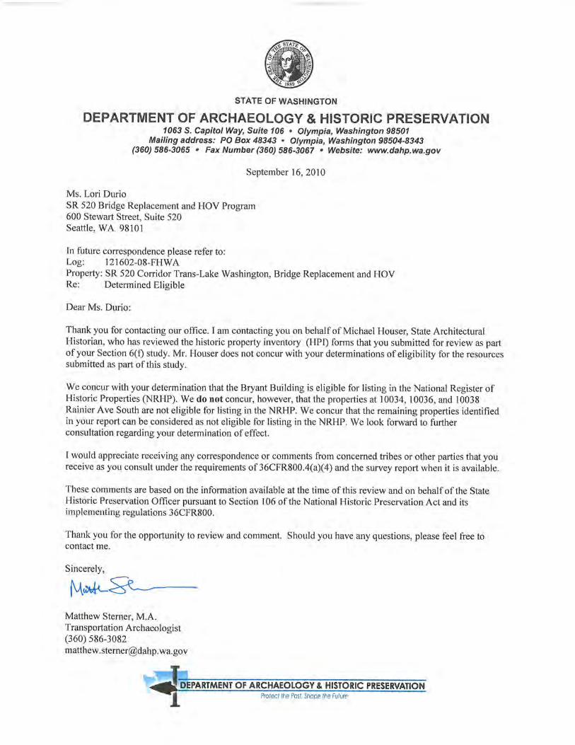
Two resources within the APE have been determined eligible for listing in the NRHP by WSDOT within the last year: the James Arnston House (2851 Evergreen Point Road) and the SR 520 Evergreen Point Bridge. An additional resource has been determined not NRHP-eligible by WSDOT in the past year: Helen Pierce House (2857 Evergreen Point Road). DAHP concurred with all three of these determinations. Therefore, we have not included the HPI forms in this submittal.
During the SR 520: I-5 to Medina Bridge Replacement and HOV Project historic resource survey, we identified, evaluated, and recorded 230 resources within the APE that were constructed prior to 1972. These have been documented on the Washington State Historic Property Inventory Database. Of these, 149 are eligible for listing in the NRHP, either individually or as contributing resource to the two NRHP eligible historic districts (Roanoke Park and Montlake). The remaining 81 evaluated resources are not eligible for listing in the NRHP, either individually or as contributing resources to historic districts.
Roanoke Park Historic District The nine-block Roanoke Park Historic District is located between E. Shelby Street on the north, 10th Avenue E. on the east, E. Roanoke Street on the south, and Harvard Avenue E. on the west, and is now completely included within the project APE. This district has been determined eligible for listing in the National Register of Historic Places (NRHP), is currently listed in the Washington Heritage Register (WHR), and is likely to be listed in the NRHP in the near future.
SR 520 Bridge Replacement and HOV Project July 16 2009 Attachment 2: Summary of Historic Resources Inventory Findings Page 1 of 2
SR 520 Bridge Replacement and HOV Project July 16 2009 Attachment 2: Summary of Historic Resources Inventory Findings Page 2 of 2
Per the direction of Dr. Allyson Brooks in the DAHP/UCO coordination meeting on May 20, 2009, and in a meeting at your office with members of the Portage Bay/Roanoke Park Community Club on May 26, 2009, WSDOT is not recording each individual property within the nine-block Roanoke Park Historic District in the Historic Property Inventory Database. Instead, WSDOT will reference—and include as an appendix in the Cultural Resources report—the NRHP nomination for this resource to assess the character-defining features of the historic property, and then will assess our undertaking's effects on the historic property. Please note, however, that WSDOT has already individually evaluated five historic resources (those closest to the SR 520 right of way) within the Roanoke Park Historic District, and those are included in this submittal. Of these, all five are contributing resources to the NRHP-eligible district, and one is also individually NRHP-eligible.
Montlake Historic District
The potential Montlake Historic District is generally defined as the area between the Lake Washington Ship Canal to the north, Lake Washington Boulevard to the east, Galer (between Lake Washington Boulevard and 24th Avenue East) to the south, Interlaken Boulevard (up to Fuhrman Ave E) to the south and west, and Portage Bay to the north and east. Within the proposed district boundaries, WSDOT evaluated 144 individual resources. 126 properties contribute to the NRHP-eligible district, 35 of which are also individually eligible for listing in the NRHP.
Individually NRHP-eligible Resources Outside of the Historic Districts
Excluding those properties that are located in potential historic districts, the survey identified 17 individually eligible properties within the APE.
Attachment 3: Historic Property Inventory Forms for all resources constructed prior to 1972.

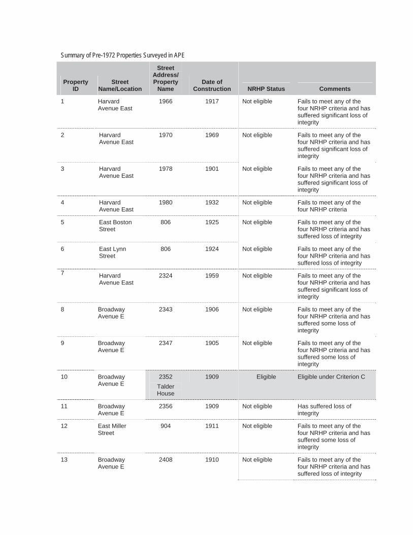
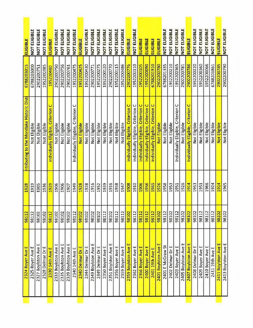
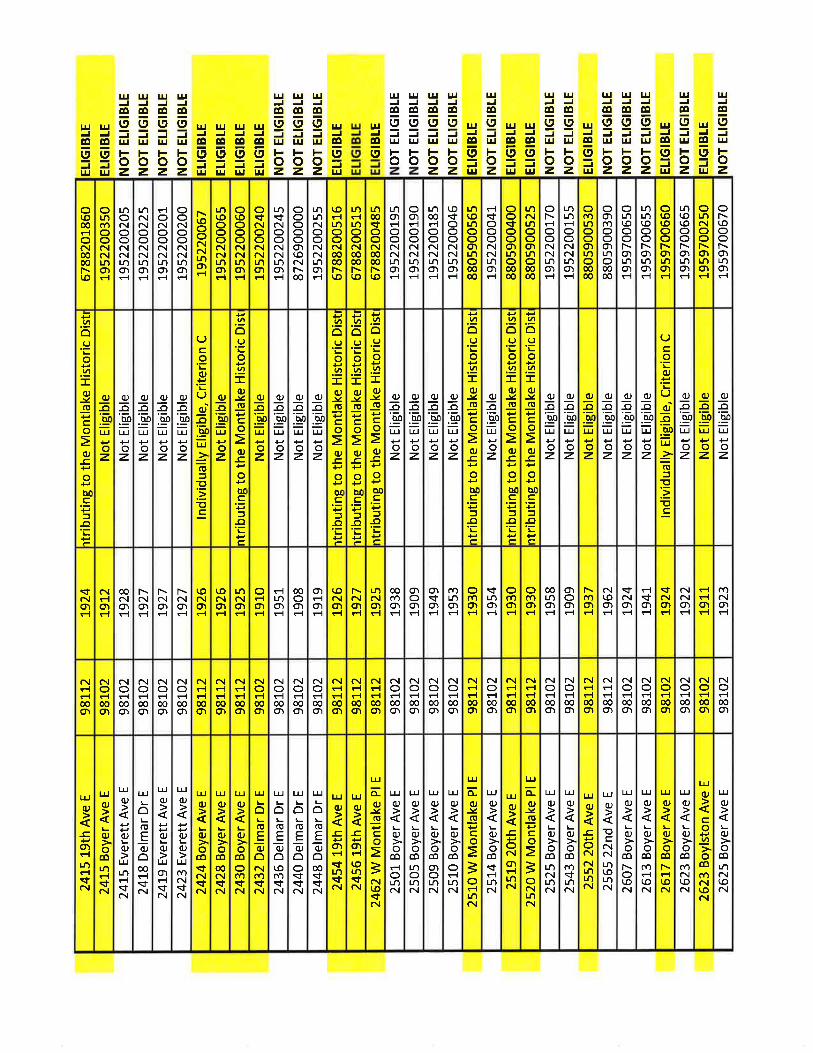
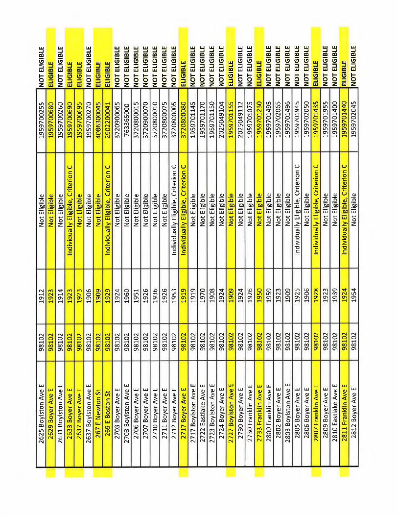
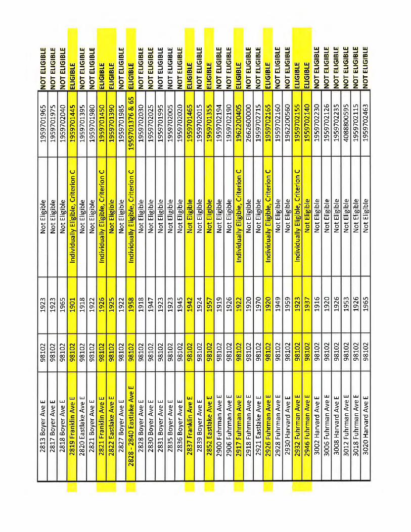
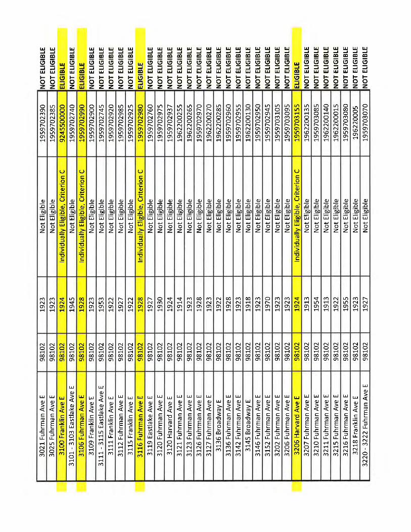
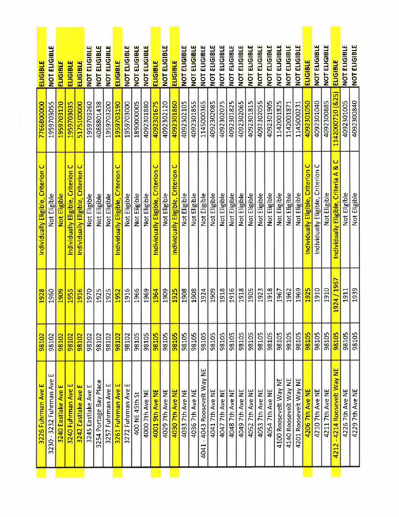
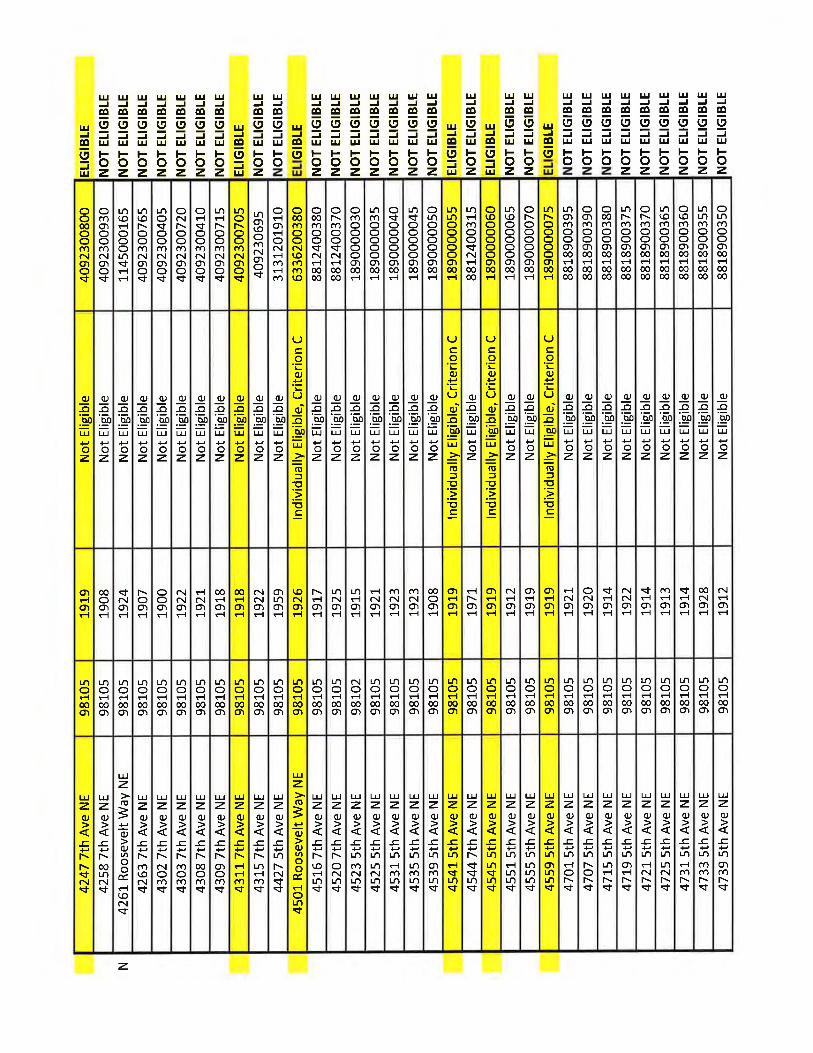
Summary of Pre-1972 Properties Surveyed in APE
Property ID
StreetName/Location
StreetAddress/ Property
Name Date of
Construction NRHP Status Comments
1 HarvardAvenue East
1966 1917 Not eligible Fails to meet any of the four NRHP criteria and has suffered significant loss of integrity
2 HarvardAvenue East
1970 1969 Not eligible Fails to meet any of the four NRHP criteria and has suffered significant loss of integrity
3 HarvardAvenue East
1978 1901 Not eligible Fails to meet any of the four NRHP criteria and has suffered significant loss of integrity
4 HarvardAvenue East
1980 1932 Not eligible Fails to meet any of the four NRHP criteria
5 East Boston Street
806 1925 Not eligible Fails to meet any of the four NRHP criteria and has suffered loss of integrity
6 East Lynn Street
806 1924 Not eligible Fails to meet any of the four NRHP criteria and has suffered loss of integrity
7 HarvardAvenue East
2324 1959 Not eligible Fails to meet any of the four NRHP criteria and has suffered significant loss of integrity
8 Broadway Avenue E
2343 1906 Not eligible Fails to meet any of the four NRHP criteria and has suffered some loss of integrity
9 Broadway Avenue E
2347 1905 Not eligible Fails to meet any of the four NRHP criteria and has suffered some loss of integrity
10 Broadway Avenue E
2352 Talder House
1909 Eligible Eligible under Criterion C
11 Broadway Avenue E
2356 1909 Not eligible Has suffered loss of integrity
12 East Miller Street
904 1911 Not eligible Fails to meet any of the four NRHP criteria and has suffered some loss of integrity
13 Broadway Avenue E
2408 1910 Not eligible Fails to meet any of the four NRHP criteria and has suffered loss of integrity
Summary of Pre-1972 Properties Surveyed in APE
Property ID
StreetName/Location
StreetAddress/ Property
Name Date of
Construction NRHP Status Comments
14 Broadway Avenue E
2412 1910 Not eligible Fails to meet any of the four NRHP criteria and has suffered loss of integrity
15 East Miller Street
910 1905 Not Eligible Fails to meet any of the four NRHP criteria
16 East Miller Street
914 1910 Not Eligible Fails to meet any of the four NRHP criteria and has suffered loss of integrity
17 10th Avenue E 2351 1930 Not eligible Fails to meet any of the four NRHP criteria and has suffered some loss of integrity
18 10th Avenue E 2401 1909 Not Eligible Fails to meet any of the four NRHP criteria and has suffered significant loss of integrity
19 10th Avenue E 2405 1909 Not Eligible Fails to meet any of the four NRHP criteria
20 10th Avenue E 2409 1921 Not Eligible Fails to meet any of the four NRHP criteria and has suffered significant loss of integrity
21 10th Avenue E 2413-15 1957; 1905 Not eligible (two buildings – 1905 and 1957) Fails to meet any of the four NRHP criteria and has suffered significant loss of integrity
22 10th Avenue E 2400 1932 Not eligible Fails to meet any of the four NRHP criteria and has suffered some loss of integrity
23 10th Avenue E 2406-08 1962 Not eligible Fails to meet any of the four NRHP criteria
24 10th Avenue E 2412 1910 Not eligible Fails to meet any of the four NRHP criteria
25 Federal Avenue E
2422 1907 Not eligible Fails to meet any of the four NRHP criteria and has suffered some loss of integrity
26 11th Avenue E 2423-2425 1910 Not eligible Fails to meet any of the four NRHP criteria and has suffered some loss of integrity
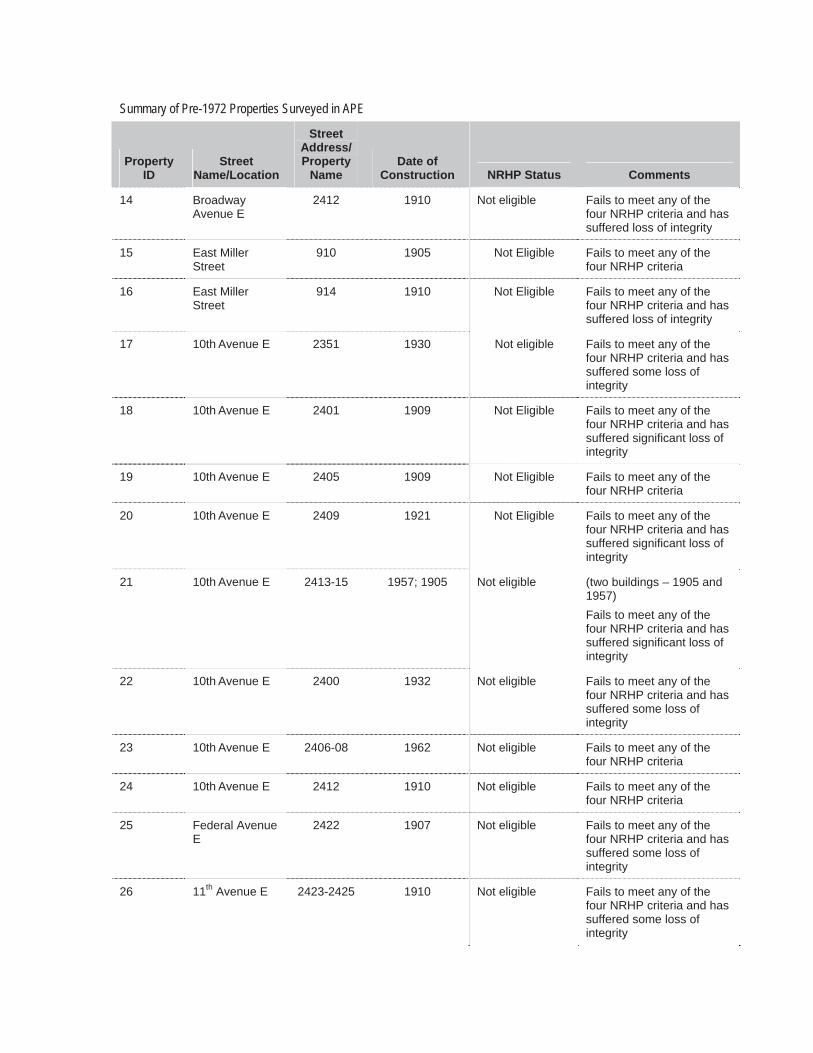
Summary of Pre-1972 Properties Surveyed in APE
Property ID
StreetName/Location
StreetAddress/ Property
Name Date of
Construction NRHP Status Comments
27 10th Avenue E Overpass 1962 Not Eligible Fails to meet any of the four NRHP criteria
28 Delmar Drive E Overpass 1962 Not Eligible Fails to meet any of the four NRHP criteria
29 Boyer Avenue E Overpass 1962 Not Eligible Fails to meet any of the four NRHP criteria
30 Delmar Drive E Bagley View Point
1908; 1970 Not Eligible Has suffered a significant loss of integrity
31 Between 11th
and 12th Avenue Roanoke
steps1908 Not Eligible Fails to meet any of the
four NRHP criteria
32 Boyer Avenue E 2545 Alden MasonHouse
1949 Eligible Eligible under Criterion C; Potentially eligible Seattle Landmark
33 Boyer Avenue E 2542 1957 Not eligible Fails to meet any of the four NRHP criteria
34 Boyer Avenue E 2534 1911 Not Eligible Fails to meet any of the four NRHP criteria and has suffered a significant loss of integrity
35 Boyer Avenue E 2524 Portage
Bay condominu
ms
1958 Not Eligible Fails to meet any of the four NRHP criteria
36 Boyer Avenue E 2518 Kelley House
1909 Eligible Eligible under Criterion C
37 East Roanoke Street
901Fire Station
#22
1965 Eligible Two buildings on one parcel; Outside of boundaries and period of significance for Roanoke Park historic district; Fire Station #22 is eligible under Criterion C
37 East Roanoke Street
901Freeway Control Office
Building
1965 Not eligible Two buildings on one parcel; Outside of boundaries and period of significance for Roanoke Park district; Freeway Control Office Building fails to meet any of the four NRHP criteria and has suffered loss of integrity
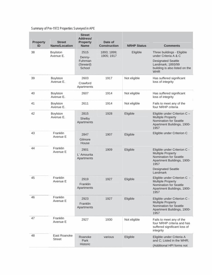
Summary of Pre-1972 Properties Surveyed in APE
Property ID
StreetName/Location
StreetAddress/ Property
Name Date of
Construction NRHP Status Comments
38 Boylston Avenue E.
2515 Denny-
Fuhrman (Seward) School
1893; 1899; 1905; 1917
Eligible Three buildings - Eligible under Criteria A & C Designated Seattle Landmark; 1893/99 building is also listed on the WHR
39 Boylston Avenue E.
2603 Crawford
Apartments
1917 Not eligible Has suffered significant loss of integrity
40 Boylston Avenue E.
2607 1914 Not eligible Has suffered significant loss of integrity
41 Boylston Avenue E.
2611 1914 Not eligible Fails to meet any of the four NRHP criteria
42 Boylston Avenue E.
2815 Shelby
Apartments
1928 Eligible Eligible under Criterion C – Multiple Property Nomination for Seattle Apartment Buildings, 1900-1957
43 Franklin Avenue E
2847 GilmoreHouse
1907 Eligible Eligible under Criterion C
44 Franklin Avenue E
2901 L’ Amourita Apartments
1909 Eligible Eligible under Criterion C - Multiple Property Nomination for Seattle Apartment Buildings, 1900-1957 Designated Seattle Landmark
45 Franklin Avenue E
2919 Franklin
Apartments
1927 Eligible Eligible under Criterion C - Multiple Property Nomination for Seattle Apartment Buildings, 1900-1957
46 Franklin Avenue E
2923 Franklin
Apartments
1927 Eligible Eligible under Criterion C - Multiple Property Nomination for Seattle Apartment Buildings, 1900-1957
47 Franklin Avenue E
2927 1930 Not eligible Fails to meet any of the four NRHP criteria and has suffered significant loss of integrity
48 East Roanoke Street
Roanoke Park
Historic
various Eligible Eligible under Criteria A and C; Listed in the WHR; (Additional HPI forms not
Summary of Pre-1972 Properties Surveyed in APE
Property ID
StreetName/Location
StreetAddress/ Property
Name Date of
Construction NRHP Status CommentsDistrict completed for this district)
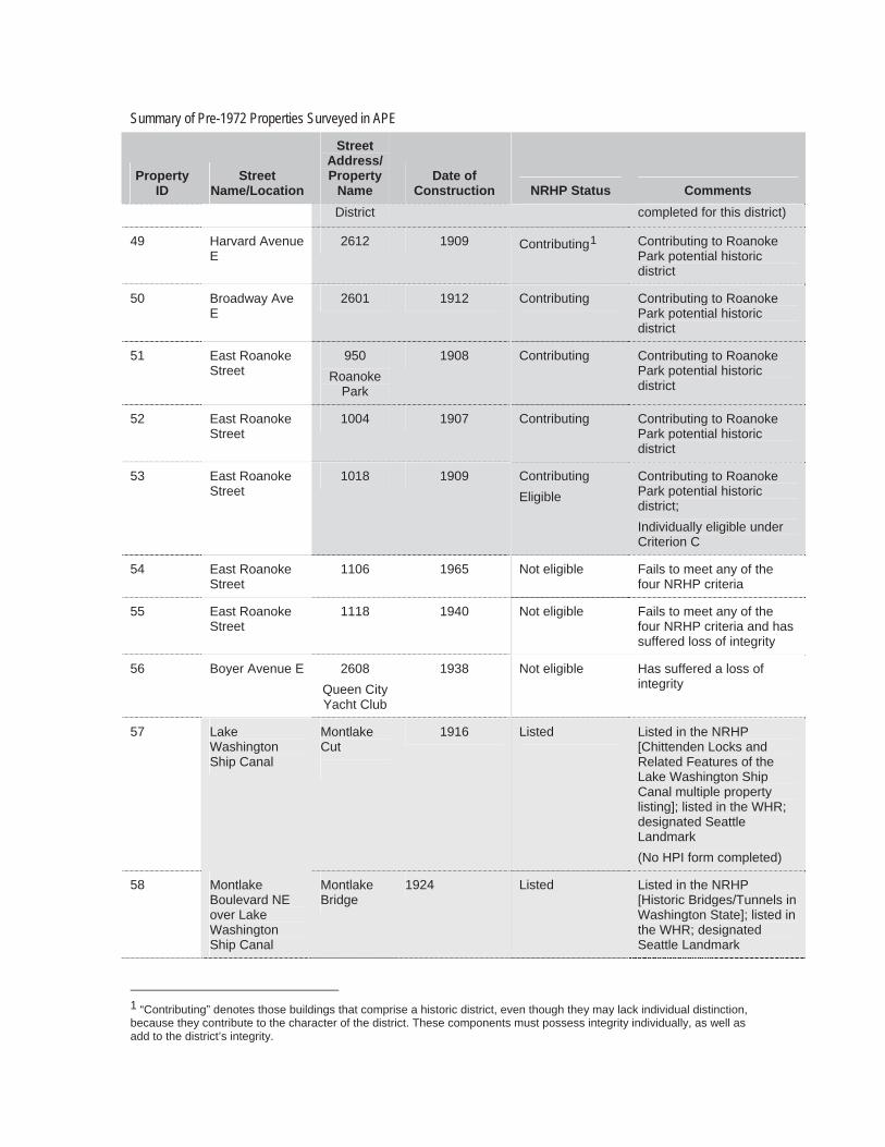
49 Harvard Avenue E
2612 1909 Contributing1 Contributing to Roanoke Park potential historic district
50 Broadway Ave E
2601 1912 Contributing Contributing to Roanoke Park potential historic district
51 East Roanoke Street
950Roanoke
Park
1908 Contributing Contributing to Roanoke Park potential historic district
52 East Roanoke Street
1004 1907 Contributing Contributing to Roanoke Park potential historic district
53 East Roanoke Street
1018 1909 Contributing Eligible
Contributing to Roanoke Park potential historic district;Individually eligible under Criterion C
54 East Roanoke Street
1106 1965 Not eligible Fails to meet any of the four NRHP criteria
55 East Roanoke Street
1118 1940 Not eligible Fails to meet any of the four NRHP criteria and has suffered loss of integrity
56 Boyer Avenue E 2608 Queen City Yacht Club
1938 Not eligible Has suffered a loss of integrity
57 LakeWashington Ship Canal
Montlake Cut
1916 Listed Listed in the NRHP [Chittenden Locks and Related Features of the Lake Washington Ship Canal multiple property listing]; listed in the WHR; designated Seattle Landmark (No HPI form completed)
58 Montlake Boulevard NE over Lake Washington Ship Canal
Montlake Bridge
1924 Listed Listed in the NRHP [Historic Bridges/Tunnels in Washington State]; listed in the WHR; designated Seattle Landmark
1 “Contributing” denotes those buildings that comprise a historic district, even though they may lack individual distinction, because they contribute to the character of the district. These components must possess integrity individually, as well as add to the district’s integrity.
Summary of Pre-1972 Properties Surveyed in APE
Property ID
StreetName/Location
StreetAddress/ Property
Name Date of
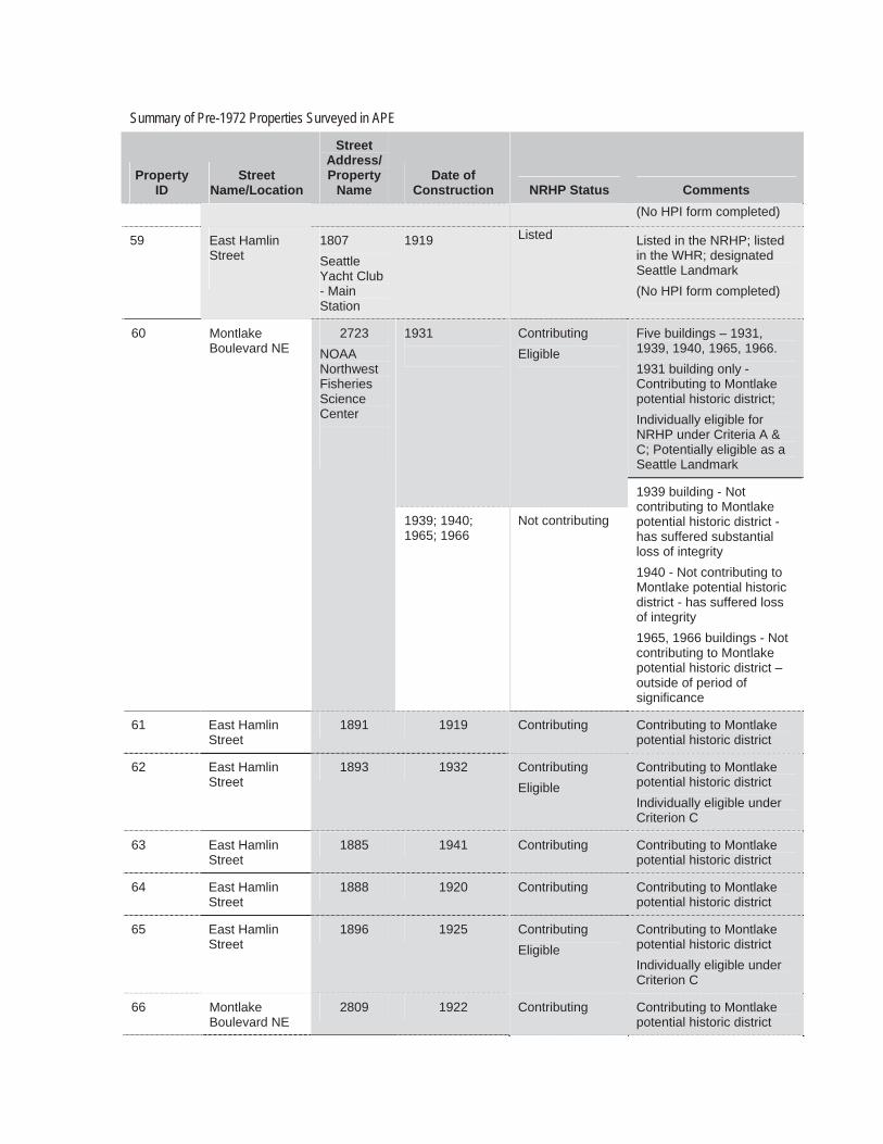
Construction NRHP Status Comments(No HPI form completed)
59 East Hamlin Street
1807SeattleYacht Club - Main Station
1919 Listed Listed in the NRHP; listed in the WHR; designated Seattle Landmark (No HPI form completed)
60 Montlake Boulevard NE
Five buildings – 1931, 1939, 1940, 1965, 1966. 1931 building only - Contributing to Montlake potential historic district; Individually eligible for NRHP under Criteria A & C; Potentially eligible as a Seattle Landmark
1931 Contributing Eligible
2723 NOAANorthwest Fisheries Science Center
1939; 1940; 1965; 1966
Not contributing
1939 building - Not contributing to Montlake potential historic district - has suffered substantial loss of integrity 1940 - Not contributing to Montlake potential historic district - has suffered loss of integrity 1965, 1966 buildings - Not contributing to Montlake potential historic district – outside of period of significance
61 East Hamlin Street
1891 1919 Contributing Contributing to Montlake potential historic district
62 East Hamlin Street
1893 1932 Contributing Eligible
Contributing to Montlake potential historic district Individually eligible under Criterion C
63 East Hamlin Street
1885 1941 Contributing Contributing to Montlake potential historic district
64 East Hamlin Street
1888 1920 Contributing Contributing to Montlake potential historic district
65 East Hamlin Street
1896 1925 Contributing Eligible
Contributing to Montlake potential historic district Individually eligible under Criterion C
66 Montlake Boulevard NE
2809 1922 Contributing Contributing to Montlake potential historic district
Summary of Pre-1972 Properties Surveyed in APE
Property ID
StreetName/Location
StreetAddress/ Property
Name Date of
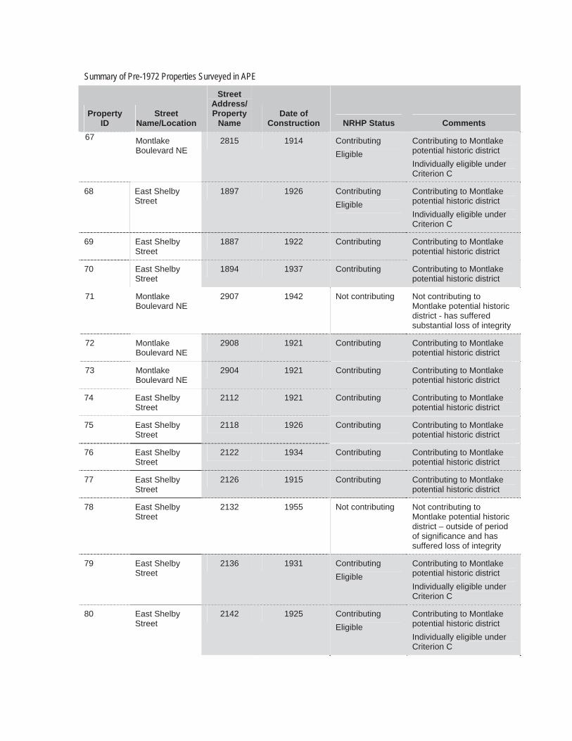
Construction NRHP Status Comments67 Montlake
Boulevard NE 2815 1914 Contributing
Eligible Contributing to Montlake potential historic district Individually eligible under Criterion C
68 East Shelby Street
1897 1926 Contributing Eligible
Contributing to Montlake potential historic district Individually eligible under Criterion C
69 East Shelby Street
1887 1922 Contributing Contributing to Montlake potential historic district
70 East Shelby Street
1894 1937 Contributing Contributing to Montlake potential historic district
71 Montlake Boulevard NE
2907 1942 Not contributing Not contributing to Montlake potential historic district - has suffered substantial loss of integrity
72 Montlake Boulevard NE
2908 1921 Contributing Contributing to Montlake potential historic district
73 Montlake Boulevard NE
2904 1921 Contributing Contributing to Montlake potential historic district
74 East Shelby Street
2112 1921 Contributing Contributing to Montlake potential historic district
75 East Shelby Street
2118 1926 Contributing Contributing to Montlake potential historic district
76 East Shelby Street
2122 1934 Contributing Contributing to Montlake potential historic district
77 East Shelby Street
2126 1915 Contributing Contributing to Montlake potential historic district
78 East Shelby Street
2132 1955 Not contributing Not contributing to Montlake potential historic district – outside of period of significance and has suffered loss of integrity
79 East Shelby Street
2136 1931 Contributing Eligible
Contributing to Montlake potential historic district Individually eligible under Criterion C
80 East Shelby Street
2142 1925 Contributing Eligible
Contributing to Montlake potential historic district Individually eligible under Criterion C
Summary of Pre-1972 Properties Surveyed in APE
Property ID
StreetName/Location
StreetAddress/ Property
Name Date of
Construction NRHP Status Comments
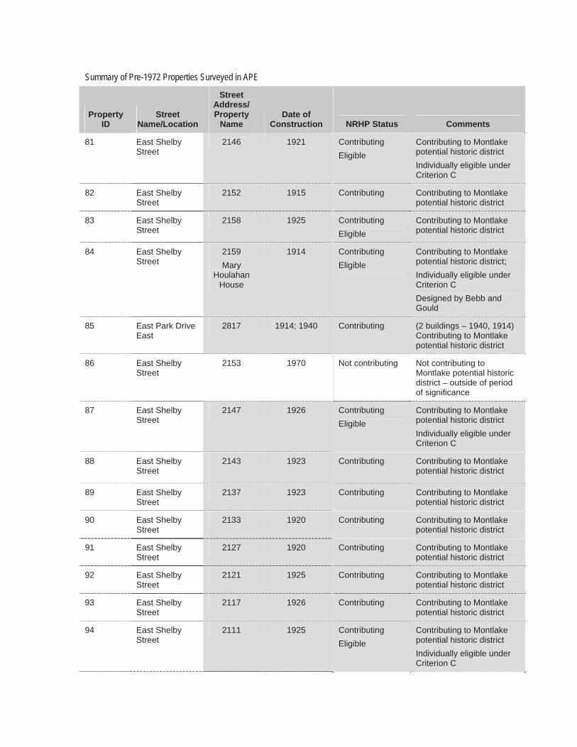
81 East Shelby Street
2146 1921 Contributing Eligible
Contributing to Montlake potential historic district Individually eligible under Criterion C
82 East Shelby Street
2152 1915 Contributing Contributing to Montlake potential historic district
83 East Shelby Street
2158 1925 Contributing Eligible
Contributing to Montlake potential historic district
84 East Shelby Street
2159 Mary
Houlahan House
1914 Contributing Eligible
Contributing to Montlake potential historic district; Individually eligible under Criterion C Designed by Bebb and Gould
85 East Park Drive East
2817 1914; 1940 Contributing (2 buildings – 1940, 1914) Contributing to Montlake potential historic district
86 East Shelby Street
2153 1970 Not contributing Not contributing to Montlake potential historic district – outside of period of significance
87 East Shelby Street
2147 1926 Contributing Eligible
Contributing to Montlake potential historic district Individually eligible under Criterion C
88 East Shelby Street
2143 1923 Contributing Contributing to Montlake potential historic district
89 East Shelby Street
2137 1923 Contributing Contributing to Montlake potential historic district
90 East Shelby Street
2133 1920 Contributing Contributing to Montlake potential historic district
91 East Shelby Street
2127 1920 Contributing Contributing to Montlake potential historic district
92 East Shelby Street
2121 1925 Contributing Contributing to Montlake potential historic district
93 East Shelby Street
2117 1926 Contributing Contributing to Montlake potential historic district
94 East Shelby Street
2111 1925 Contributing Eligible
Contributing to Montlake potential historic district Individually eligible under Criterion C
Summary of Pre-1972 Properties Surveyed in APE
Property ID
StreetName/Location
StreetAddress/ Property
Name Date of
Construction NRHP Status Comments95 Montlake
Boulevard NE 2818 1920 Contributing Contributing to Montlake
potential historic district
96 Montlake Boulevard NE
2812 1922 Contributing Contributing to Montlake potential historic district
97 Montlake Boulevard NE
2810 1915 Contributing Contributing to Montlake potential historic district
98 East Hamlin Street
2110 1924 Contributing Eligible
Contributing to Montlake potential historic district Individually eligible under Criterion C
99 East Hamlin Street
2112 1915 Contributing Contributing to Montlake potential historic district
100 East Hamlin Street
2122 1926 Contributing Contributing to Montlake potential historic district
101 East Hamlin Street
2128 1922 Contributing Contributing to Montlake potential historic district
102 East Hamlin Street
2130 1922 Contributing Contributing to Montlake potential historic district
103 East Hamlin Street
2136 1926 Contributing Contributing to Montlake potential historic district
104 East Hamlin Street
2142 1949 Contributing Contributing to Montlake potential historic district
105 East Hamlin Street
2146 1920 Contributing Eligible
Contributing to Montlake potential historic district Individually eligible under Criterion C
106 East Hamlin Street
2150 1930 Contributing Contributing to Montlake potential historic district
107 East Hamlin Street
2160 1920 Contributing Contributing to Montlake potential historic district
108 LakeWashington Blvd. E
2720 (aka 2161 E. Hamlin
St.)Museum of History and
Industry (MOHAI)
1950-52 Contributing Contributing to Montlake potential historic district
109 East Hamlin Street
2151 1923 Contributing Contributing to Montlake potential historic district
Summary of Pre-1972 Properties Surveyed in APE
Property ID
StreetName/Location
StreetAddress/ Property
Name Date of
Construction NRHP Status Comments
110 East Hamlin Street
2147 1924 Contributing Contributing to Montlake potential historic district
111 East Hamlin Street
2141 1923 Contributing Contributing to Montlake potential historic district
112 East Hamlin Street
2137 1925 Contributing Contributing to Montlake potential historic district
113 East Hamlin Street
2133 1919 Contributing Eligible
Contributing to Montlake potential historic district Individually eligible under Criterion C
114 East Hamlin Street
2127 1924 Contributing Eligible
Contributing to Montlake potential historic district Individually eligible under Criterion C
115 East Hamlin Street
2121 1927 Contributing Eligible
Contributing to Montlake potential historic district Individually eligible under Criterion C
116 East Hamlin Street
2117 1914 Contributing Contributing to Montlake potential historic district
117 East Hamlin Street
2111 1925 Contributing Contributing to Montlake potential historic district
118 Montlake Boulevard NE
2740 1920 Not Contributing Not contributing to Montlake potential historic district - has suffered substantial loss of integrity
119 Montlake Boulevard NE
2734 1919 Contributing Contributing to Montlake potential historic district
120 East Montlake Place East
2625 Union 76 ServiceStation
1952 Not contributing Not contributing to Montlake potential historic district - has suffered substantial loss of integrity
121 22nd Avenue East
2605 Hop In
Grocery
1937 Not contributing Not contributing to Montlake potential historic district - has suffered significant loss of integrity
122 West Montlake Place East
2575 1951 Contributing Contributing to Montlake potential historic district;
123 West Montlake Place East
2571 1938 Contributing Contributing to Montlake potential historic district;
Summary of Pre-1972 Properties Surveyed in APE
Property ID
StreetName/Location
StreetAddress/ Property
Name Date of
Construction NRHP Status Comments
124 West Montlake Place East
2563 1937 Not contributing Not contributing to Montlake potential historic district - has suffered substantial loss of integrity
125 West Montlake Place East
2553 1936 Contributing Contributing to Montlake potential historic district;
126 West Montlake Place East
2521 1937 Contributing Contributing to Montlake potential historic district;
127 West Montlake Place East
2511 1931 Contributing Eligible
Contributing to Montlake potential historic district; Individually eligible under Criterion C
128 West Montlake Place East
2507 1929 Contributing Contributing to Montlake potential historic district;
129 West Montlake Place East
2501 1931 Contributing Eligible
Contributing to Montlake potential historic district; Individually eligible under Criterion C
130 East Calhoun Street
1618 Montlake
Community Center
1935 Contributing Eligible
Contributing to Montlake potential historic district; Individually eligible under Criteria A & C Designated Seattle Landmark
131 20th Avenue East
2552 1937 Contributing Contributing to Montlake potential historic district
132 West Montlake Place East
2564 1947 Contributing Contributing to Montlake potential historic district;
133 East Roanoke Street
2009 1950 Contributing Contributing to Montlake potential historic district
134 East Roanoke Street
2015 1949 Not contributing Not contributing to Montlake potential historic district - has suffered substantial loss of integrity
135 East Roanoke Street
2023 1952 Contributing Contributing to Montlake potential historic district
136 22nd Avenue East
2565 1962 Not contributing Not contributing to Montlake potential historic district - outside of period of significance for Montlake historic district and has suffered significant loss of integrity
Summary of Pre-1972 Properties Surveyed in APE
Property ID
StreetName/Location
StreetAddress/ Property
Name Date of
Construction NRHP Status Comments
137 East Roanoke Street
2201 1910 Not contributing Not contributing to Montlake potential historic district - has suffered substantial loss of integrity
138 East Roanoke Street
2205 1947 Not contributing Not contributing to Montlake potential historic district - has suffered substantial loss of integrity
139 East Roanoke Street
2209 1921 Contributing Contributing to Montlake potential historic district
140 East Montlake Place East
2571 1951 Contributing Contributing to Montlake potential historic district
141 East Louisa Street
2216 1922 Not contributing Not contributing to Montlake potential historic district - has suffered substantial loss of integrity
142 East Louisa Street
2220 1930 Contributing Eligible
Contributing to Montlake potential historic district; Individually eligible under Criterion C
143 East Louisa Street
2226 1926 Contributing Contributing to Montlake potential historic district;
144 24th Avenue East
2515 1933 Contributing Contributing to Montlake potential historic district
145 East Miller Street
2230 1954 Not Contributing Not contributing to Montlake potential historic district – outside of period of significance and has suffered loss of integrity
146 East Miller Street
2233 1934 Contributing Contributing to Montlake potential historic district
147 24th Avenue East
2459 1934 Contributing Contributing to Montlake potential historic district
148 24th Avenue East
2455 1939 Contributing Contributing to Montlake potential historic district
149 24th Avenue East
2415 1924 Contributing Contributing to Montlake potential historic district
150 24th Avenue East
2402 1920 Contributing Eligible
Contributing to Montlake potential historic district Individually eligible under Criterion C
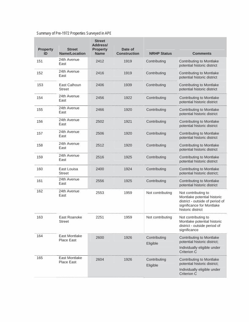
Summary of Pre-1972 Properties Surveyed in APE
Property ID
StreetName/Location
StreetAddress/ Property
Name Date of
Construction NRHP Status Comments
151 24th Avenue East
2412 1919 Contributing Contributing to Montlake potential historic district
152 24th Avenue East
2416 1919 Contributing Contributing to Montlake potential historic district
153 East Calhoun Street
2406 1939 Contributing Contributing to Montlake potential historic district
154 24th Avenue East
2456 1922 Contributing Contributing to Montlake potential historic district
155 24th Avenue East
2466 1920 Contributing Contributing to Montlake potential historic district
156 24th Avenue East
2502 1921 Contributing Contributing to Montlake potential historic district
157 24th Avenue East
2506 1920 Contributing Contributing to Montlake potential historic district
158 24th Avenue East
2512 1920 Contributing Contributing to Montlake potential historic district
159 24th Avenue East
2516 1925 Contributing Contributing to Montlake potential historic district
160 East Louisa Street
2400 1924 Contributing Contributing to Montlake potential historic district;
161 24th Avenue East
2556 1925 Contributing Contributing to Montlake potential historic district
162 24th Avenue East
2553 1959 Not contributing Not contributing to Montlake potential historic district - outside of period of significance for Montlake historic district
163 East Roanoke Street
2251 1959 Not contributing Not contributing to Montlake potential historic district - outside period of significance
164 East Montlake Place East
2600 1926 Contributing Eligible
Contributing to Montlake potential historic district; Individually eligible under Criterion C
165 East Montlake Place East
2604 1926 Contributing Eligible
Contributing to Montlake potential historic district; Individually eligible under Criterion C
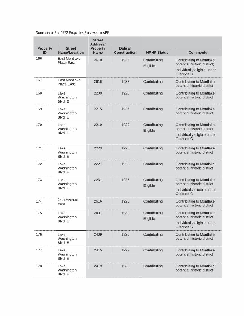
Summary of Pre-1972 Properties Surveyed in APE
Property ID
StreetName/Location
StreetAddress/ Property
Name Date of
Construction NRHP Status Comments166 East Montlake
Place East 2610 1926 Contributing
Eligible Contributing to Montlake potential historic district; Individually eligible under Criterion C
167 East Montlake Place East
2616 1938 Contributing Contributing to Montlake potential historic district
168 LakeWashington Blvd. E
2209 1925 Contributing Contributing to Montlake potential historic district
169 LakeWashington Blvd. E
2215 1937 Contributing Contributing to Montlake potential historic district
170 LakeWashington Blvd. E
2219 1929 Contributing Eligible
Contributing to Montlake potential historic district Individually eligible under Criterion C
171 LakeWashington Blvd. E
2223 1928 Contributing Contributing to Montlake potential historic district
172 LakeWashington Blvd. E
2227 1925 Contributing Contributing to Montlake potential historic district
173 LakeWashington Blvd. E
2231 1927 Contributing Eligible
Contributing to Montlake potential historic district Individually eligible under Criterion C
174 24th Avenue East
2616 1926 Contributing Contributing to Montlake potential historic district
175 LakeWashington Blvd. E
2401 1930 Contributing Eligible
Contributing to Montlake potential historic district Individually eligible under Criterion C
176 LakeWashington Blvd. E
2409 1920 Contributing Contributing to Montlake potential historic district
177 LakeWashington Blvd. E
2415 1922 Contributing Contributing to Montlake potential historic district
178 LakeWashington Blvd. E
2419 1935 Contributing Contributing to Montlake potential historic district
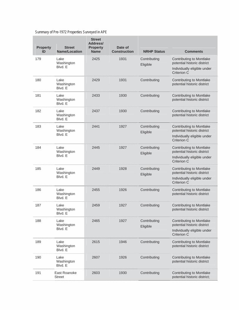
Summary of Pre-1972 Properties Surveyed in APE
Property ID
StreetName/Location
StreetAddress/ Property
Name Date of
Construction NRHP Status Comments
179 LakeWashington Blvd. E
2425 1931 Contributing Eligible
Contributing to Montlake potential historic district Individually eligible under Criterion C
180 LakeWashington Blvd. E
2429 1931 Contributing Contributing to Montlake potential historic district
181 LakeWashington Blvd. E
2433 1930 Contributing Contributing to Montlake potential historic district
182 LakeWashington Blvd. E
2437 1930 Contributing Contributing to Montlake potential historic district
183 LakeWashington Blvd. E
2441 1927 Contributing Eligible
Contributing to Montlake potential historic district Individually eligible under Criterion C
184 LakeWashington Blvd. E
2445 1927 Contributing Eligible
Contributing to Montlake potential historic district Individually eligible under Criterion C
185 LakeWashington Blvd. E
2449 1928 Contributing Eligible
Contributing to Montlake potential historic district Individually eligible under Criterion C
186 LakeWashington Blvd. E
2455 1926 Contributing Contributing to Montlake potential historic district
187 LakeWashington Blvd. E
2459 1927 Contributing Contributing to Montlake potential historic district
188 LakeWashington Blvd. E
2465 1927 Contributing Eligible
Contributing to Montlake potential historic district Individually eligible under Criterion C
189 LakeWashington Blvd. E
2615 1946 Contributing Contributing to Montlake potential historic district
190 LakeWashington Blvd. E
2607 1926 Contributing Contributing to Montlake potential historic district
191 East Roanoke Street
2603 1930 Contributing Contributing to Montlake potential historic district;
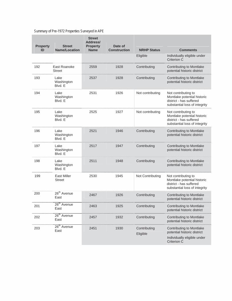
Summary of Pre-1972 Properties Surveyed in APE
Property ID
StreetName/Location
StreetAddress/ Property
Name Date of
Construction NRHP Status CommentsEligible Individually eligible under
Criterion C
192 East Roanoke Street
2559 1928 Contributing Contributing to Montlake potential historic district
193 LakeWashington Blvd. E
2537 1928 Contributing Contributing to Montlake potential historic district
194 LakeWashington Blvd. E
2531 1926 Not contributing Not contributing to Montlake potential historic district - has suffered substantial loss of integrity
195 LakeWashington Blvd. E
2525 1927 Not contributing Not contributing to Montlake potential historic district - has suffered substantial loss of integrity
196 LakeWashington Blvd. E
2521 1946 Contributing Contributing to Montlake potential historic district
197 LakeWashington Blvd. E
2517 1947 Contributing Contributing to Montlake potential historic district
198 LakeWashington Blvd. E
2511 1948 Contributing Contributing to Montlake potential historic district
199 East Miller Street
2530 1945 Not Contributing Not contributing to Montlake potential historic district - has suffered substantial loss of integrity
200 26th Avenue East
2467 1926 Contributing Contributing to Montlake potential historic district
201 26th Avenue East
2463 1925 Contributing Contributing to Montlake potential historic district
202 26th Avenue East
2457 1932 Contributing Contributing to Montlake potential historic district
203 26th Avenue East
2451 1930 Contributing Eligible
Contributing to Montlake potential historic district Individually eligible under Criterion C
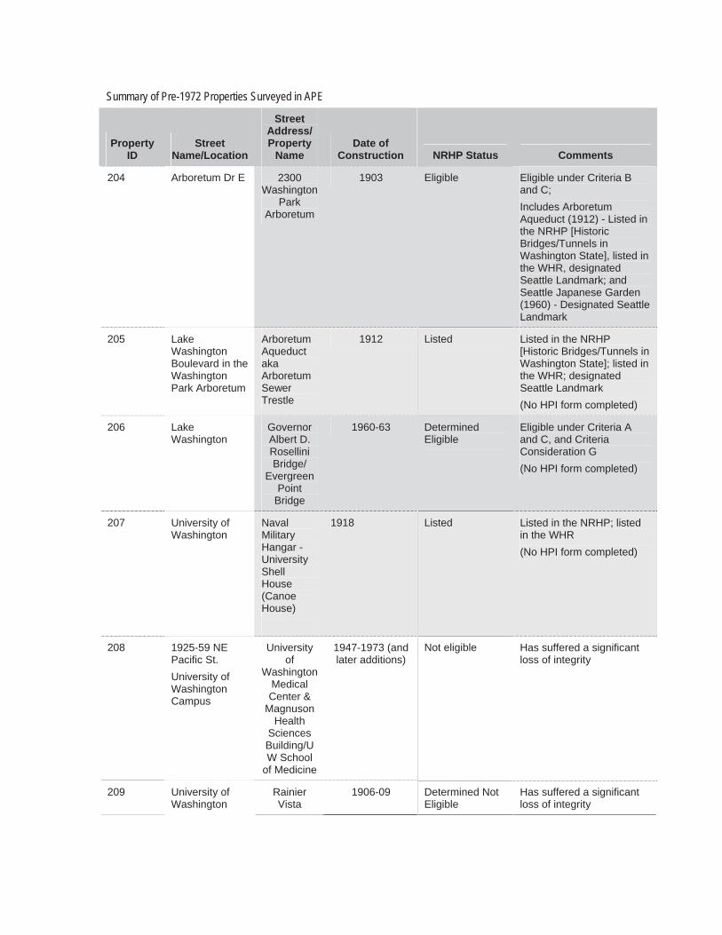
Summary of Pre-1972 Properties Surveyed in APE
Property ID
StreetName/Location
StreetAddress/ Property
Name Date of
Construction NRHP Status Comments
204 Arboretum Dr E 2300 Washington
ParkArboretum
1903 Eligible Eligible under Criteria B and C;Includes Arboretum Aqueduct (1912) - Listed in the NRHP [Historic Bridges/Tunnels in Washington State], listed in the WHR, designated Seattle Landmark; and Seattle Japanese Garden (1960) - Designated Seattle Landmark
205 LakeWashington Boulevard in the Washington Park Arboretum
ArboretumAqueduct akaArboretumSewer Trestle
1912 Listed Listed in the NRHP [Historic Bridges/Tunnels in Washington State]; listed in the WHR; designated Seattle Landmark (No HPI form completed)
206 LakeWashington
GovernorAlbert D. Rosellini Bridge/
Evergreen Point
Bridge
1960-63 DeterminedEligible
Eligible under Criteria A and C, and Criteria Consideration G (No HPI form completed)
207 University of Washington
NavalMilitary Hangar - University Shell House (Canoe House)
1918 Listed Listed in the NRHP; listed in the WHR (No HPI form completed)
208 1925-59 NE Pacific St.University of Washington Campus
University of
Washington Medical Center &
Magnuson Health
Sciences Building/UW School
of Medicine
1947-1973 (and later additions)
Not eligible Has suffered a significant loss of integrity
209 University of Washington
Rainier Vista
1906-09 Determined Not Eligible
Has suffered a significant loss of integrity
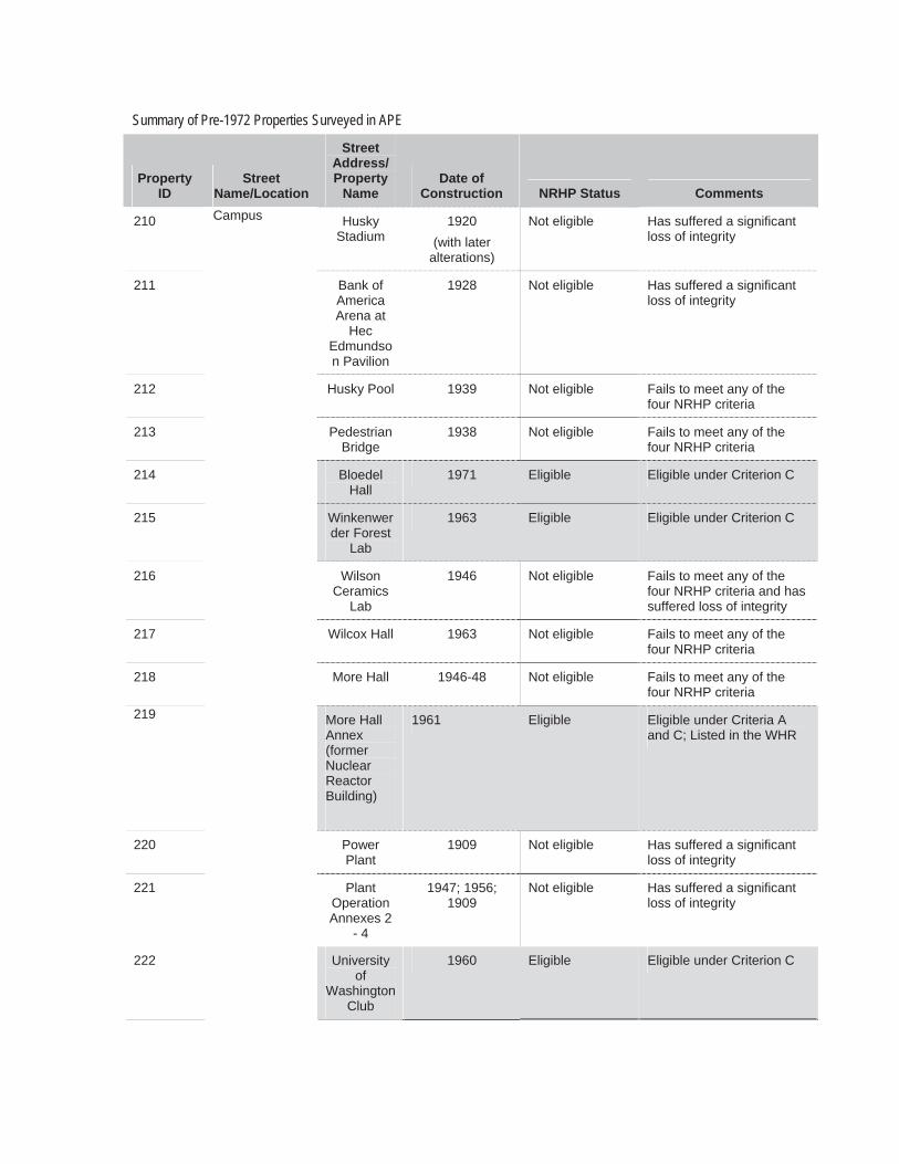
Summary of Pre-1972 Properties Surveyed in APE
Property ID
StreetName/Location
StreetAddress/ Property
Name Date of
Construction NRHP Status Comments
210 Husky Stadium
1920 (with later
alterations)
Not eligible Has suffered a significant loss of integrity
211 Bank of AmericaArena at
HecEdmundson Pavilion
1928 Not eligible Has suffered a significant loss of integrity
212 Husky Pool 1939 Not eligible Fails to meet any of the four NRHP criteria
213 Pedestrian Bridge
1938 Not eligible Fails to meet any of the four NRHP criteria
214 Bloedel Hall
1971 Eligible Eligible under Criterion C
215 Winkenwerder Forest
Lab
1963 Eligible Eligible under Criterion C
216 WilsonCeramics
Lab
1946 Not eligible Fails to meet any of the four NRHP criteria and has suffered loss of integrity
217 Wilcox Hall 1963 Not eligible Fails to meet any of the four NRHP criteria
218 More Hall 1946-48 Not eligible Fails to meet any of the four NRHP criteria
219 More Hall Annex (formerNuclear ReactorBuilding)
1961 Eligible Eligible under Criteria A and C; Listed in the WHR
220 Power Plant
1909 Not eligible Has suffered a significant loss of integrity
221
Campus
PlantOperation Annexes 2
- 4
1947; 1956; 1909
Not eligible Has suffered a significant loss of integrity
222 University of
Washington Club
1960 Eligible Eligible under Criterion C
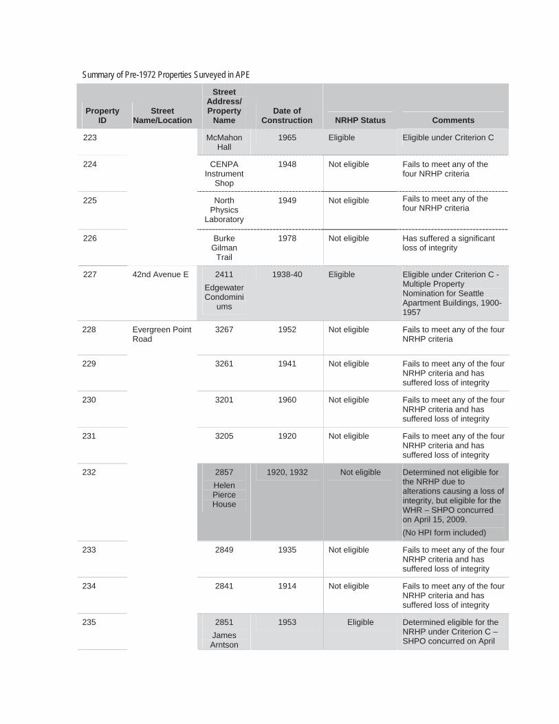
Summary of Pre-1972 Properties Surveyed in APE
Property ID
StreetName/Location
StreetAddress/ Property
Name Date of
Construction NRHP Status Comments
223 McMahon Hall
1965 Eligible Eligible under Criterion C
224 CENPAInstrument
Shop
1948 Not eligible Fails to meet any of the four NRHP criteria
225 NorthPhysics
Laboratory
1949 Not eligible Fails to meet any of the four NRHP criteria
226 BurkeGilman
Trail
1978 Not eligible Has suffered a significant loss of integrity
227 42nd Avenue E 2411 Edgewater Condomini
ums
1938-40 Eligible Eligible under Criterion C - Multiple Property Nomination for Seattle Apartment Buildings, 1900-1957
228 3267 1952 Not eligible Fails to meet any of the four NRHP criteria
229 3261 1941 Not eligible Fails to meet any of the four NRHP criteria and has suffered loss of integrity
230 3201 1960 Not eligible Fails to meet any of the four NRHP criteria and has suffered loss of integrity
231 3205 1920 Not eligible Fails to meet any of the four NRHP criteria and has suffered loss of integrity
232 2857 Helen PierceHouse
1920, 1932 Not eligible Determined not eligible for the NRHP due to alterations causing a loss of integrity, but eligible for the WHR – SHPO concurred on April 15, 2009. (No HPI form included)
233 2849 1935 Not eligible Fails to meet any of the four NRHP criteria and has suffered loss of integrity
234 2841 1914 Not eligible Fails to meet any of the four NRHP criteria and has suffered loss of integrity
235
Evergreen Point Road
2851 JamesArntson
1953 Eligible Determined eligible for the NRHP under Criterion C – SHPO concurred on April
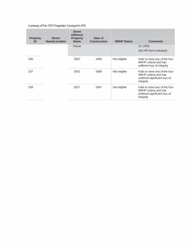
Summary of Pre-1972 Properties Surveyed in APE
Property ID
StreetName/Location
StreetAddress/ Property
Name Date of
Construction NRHP Status CommentsHouse 15, 2009.
(No HPI form included)
236 2837 1956 Not eligible Fails to meet any of the four NRHP criteria and has suffered loss of integrity
237 2651 1958 Not eligible Fails to meet any of the four NRHP criteria and has suffered significant loss of integrity
238 2617 1947 Not eligible Fails to meet any of the four NRHP criteria and has suffered significant loss of integrity

A copy of the following letter #2-4 was sent to the following individual:
Date Subject From To Corresp. Ref. No.
8/27/2009 Revised Area of Potential Effects Comments SR 520 Bridge Replacement and HOV Project
Marsh Tolon WSDOT Environmental Lead
Jon H. Decker Montlake Community Club 2311 16th Avenue East Seattle, WA 98112
LTR #114

August 27, 2009
LTR # 114
Jon H. Decker Montlake Community Club 2311 16th Avenue East Seattle, WA 98112
RE: Revised Area of Potential Effects Comments SR 520 Bridge Replacement and HOV Project
Dear Mr. Decker:
Thank you for your letter dated July 30, 2009 and review comments regarding the revised Area of Potential Effect (APE) and property inventory information for the SR 520 Bridge Replacement and HOV Project. Following are our responses to your paraphrased questions. I hope you will find our response adequate, and will contact us if further questions arise.
1. Request for specific information on the potential construction process occurring in the Montlake Community regarding:
a. St. Demetrious Church Fall Festival Thank you for the reminder to consider how construction activities may affect the annual Fall Festival and to devise ways to either avoid or minimize potential effects. While the church is not included in the APE, any potential effects that construction activities may pose to the Fall Festival at St. Demetrious Church would be considered as part of the proposed project.
b. The inclusion of West Montlake Park and adjacent properties on East Hamlin and East Shelby Streets, and areas east to Montlake Boulevard East, in the APE. The areas you have defined are part of the eligible Montlake Historic District, which is regarded as one discrete resource. Project activities that cause effect to any part of the district would be viewed as an effect to the district as a whole or as one resource.The APE is drawn with a conservative hand because it encompasses the proposed construction limits and the immediately adjacent properties, which is an area that is inventoried and surveyed. Since parts of the district are already included within the APE, and the district is one historic resource, effects to the entire district would be considered as part of the project analysis. Yet, by drawing the APE close to the
Letter #2-4

A copy of the following letter #2-5 was sent to the following individual:
Date Subject From To Coressp. Ref. No.
8/27/2009 Revised Area of Potential Effects Comments SR 520 Bridge Replacement and HOV Project
Marsh Tolon WSDOT Environmental Lead
Larry Sinnott Friends of Seattle’s Olmsted Parks 7043 21st Avenue NE Seattle, WA 98115
LTR #112

Letter #2-5


A copy of the following letter #2-6 was sent to the following individual:
Date Subject From To Corresp. Ref. No.
8/27/2009 Revised Area of Potential Effects Comments SR 520 Bridge Replacement and HOV Project
Marsh Tolon WSDOT Environmental Lead
Eugenia Woo Director of Preservation Services Historic Seattle 1117 Minor Avenue Seattle, WA 98101
LTR #113

August 27, 2009
LTR # 113
Eugenia Woo Director of Preservation Services Historic Seattle 1117 Minor Avenue Seattle, WA 98101
RE: Revised Area of Potential Effects Comments SR 520 Bridge Replacement and HOV Project
Dear Ms. Woo:
Thank you for your participation as a Section 106 consulting party for the SR 520 I-5 to Medina Bridge Replacement and HOV project. We appreciate your comments on the Historic Property Inventory forms in your letter dated July 31, 2009. Below please find our responses to your comments.
1. Thank you for alerting us about the missing photos for 2561, 2837, and 3201 Evergreen Point Road. Enclosed please find updated forms, with pictures, for those properties.
2. Thank you very much for the additional information about 2810 Montlake Boulevard NE. We will integrate this information into the statement of significance. In addition, according to the King County Assessor's Database, the property address is 2810 Montlake Boulevard NE (not E). We recognize it is confusing, because the street name there is "Montlake Boulevard E." However, we will continue to reference the King County Assessor's property nomenclature.
3. Thank you for the update on the NRHP status of the More Hall Annex (UW Nuclear Reactor) Building. At the time we completed the HPI form, it had not yet been accepted for listing in the NRHP. We have contacted Michael Houser at DAHP to ascertain the current status of the NRHP listing of the More Hall Annex Building.
4. Thank you for alerting us about the pedestrian bridges on Montlake Boulevard NE. We will record those and make determinations of NRHP eligibility. We will submit those to you for comment.
5. Regarding the use of the Historic Property Inventory form National Register Opinion Determination, it is our understanding that listing contributing resources to a potential historic district such as MOHAI (and others) as NRHP eligible is appropriate. As noted on page 46 of the DAHP Database User's Manual, selecting yes "will indicate to DAHP staff that the propertymay merit consideration for National Register eligibility."
Letter #2-6

A Copy of the following letter #2-7 was sent to the following individual:
Date Subject From To Corresp. Ref. No.
8/27/2009 Revised Area of Potential Effects Comments SR 520 Bridge Replacement and HOV Project
Marsh Tolon WSDOT Environmental Lead
C. Fred Roed, Commodore 1807 East Hamlin Street Seattle Yacht Club Seattle, WA 98112
LTR #115

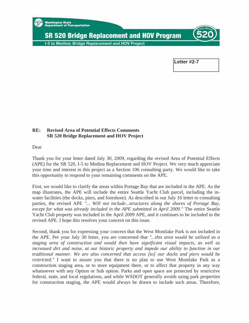
August 27, 2009
LTR # 115
C. Fred Roed, Commodore 1807 East Hamlin Street Seattle Yacht Club Seattle, WA 98112
RE: Revised Area of Potential Effects Comments SR 520 Bridge Replacement and HOV Project
Dear Commodore Roed:
Thank you for your letter dated July 30, 2009, regarding the revised Area of Potential Effects (APE) for the SR 520, I-5 to Medina Replacement and HOV Project. We very much appreciate your time and interest in this project as a Section 106 consulting party. We would like to take this opportunity to respond to your remaining comments on the APE.
First, we would like to clarify the areas within Portage Bay that are included in the APE. As the map illustrates, the APE will include the entire Seattle Yacht Club parcel, including the in-water facilities (the docks, piers, and foreshore). As described in our July 16 letter to consultingparties, the revised APE "... Will not include...structures along the shores of Portage Bay, except for what was already included in the APE submitted in April 2009." The entire Seattle Yacht Club property was included in the April 2009 APE, and it continues to be included in the revised APE. I hope this resolves your concern on this issue.
Second, thank you for expressing your concern that the West Montlake Park is not included in the APE. Per your July 30 letter, you are concerned that "...this area would be utilized as a staging area of construction and would then have significant visual impacts, as well as increased dirt and noise, at our historic property and impede our ability to function in our traditional manner. We are also concerned that access [to] our docks and piers would be restricted." I want to assure you that there is no plan to use West Montlake Park as a construction staging area, or to store equipment there, or to affect that property in any way whatsoever with any Option or Sub option. Parks and open space are protected by restrictive federal, state, and local regulations, and while WSDOT generally avoids using park properties for construction staging, the APE would always be drawn to include such areas. Therefore,
Letter #2-7
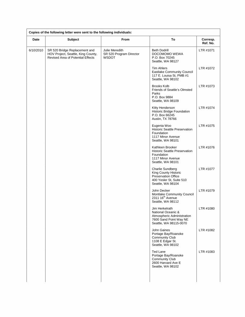
Copies of the following letter were sent to the following individuals:
Date Subject From To Corresp. Ref. No.
6/10/2010 SR 520 Bridge Replacement and HOV Project, Seattle, King County, Revised Area of Potential Effects
Julie Meredith SR 520 Program Director WSDOT
Beth Dodrill DOCOMOMO WEWA P.O. Box 70245 Seattle, WA 98127
LTR #1071
Tim Ahlers Eastlake Community Council 117 E. Louisa St, PMB #1 Seattle, WA 98102
LTR #1072
Brooks Kolb Friends of Seattle’s Olmsted Parks P.O. Box 9884 Seattle, WA 98109
LTR #1073
Kitty Henderson Historic Bridge Foundation P.O. Box 66245 Austin, TX 78766
LTR #1074
Eugenia Woo Historic Seattle Preservation Foundation 1117 Minor Avenue Seattle, WA 98101
LTR #1075
Kathleen Brooker Historic Seattle Preservation Foundation 1117 Minor Avenue Seattle, WA 98101
LTR #1076
Charlie Sundberg King County Historic Preservation Office 400 Yesler St, Suite 510 Seattle, WA 98104
LTR #1077
John Decker Montlake Community Council 2311 16th Avenue Seattle, WA 98112
LTR #1079
Jim Herkelrath National Oceanic & Atmospheric Administration 7600 Sand Point Way NE Seattle, WA 98115-0070
LTR #1080
John Gaines Portage Bay/Roanoke Community Club 1108 E Edgar St. Seattle, WA 98102
LTR #1082
Ted Lane Portage Bay/Roanoke Community Club 2600 Harvard Ave E Seattle, WA 98102
LTR #1083
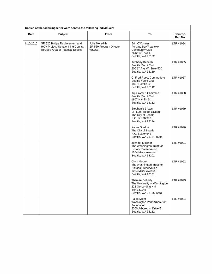
Copies of the following letter were sent to the following individuals:
Date Subject From To Corresp. Ref. No.
6/10/2010 SR 520 Bridge Replacement and HOV Project, Seattle, King County, Revised Area of Potential Effects
Julie Meredith SR 520 Program Director WSDOT
Erin O’Conner Portage Bay/Roanoke Community Club 2612 10th Ave E Seattle, WA 98102
LTR #1084
Kimberly Demuth Seattle Yacht Club 200 1st Ave W, Suite 500 Seattle, WA 98119
LTR #1085
C. Fred Roed, Commodore Seattle Yacht Club 1807 Hamlin St Seattle, WA 98112
LTR #1087
Kip Cramer, Chairman Seattle Yacht Club 1807 Hamlin St Seattle, WA 98112
LTR #1088
Stephanie Brown SR 520 Project Liaison The City of Seattle P.O. Box 34996 Seattle, WA 98124
LTR #1089
Karen Gordon The City of Seattle P.O. Box 94649 Seattle, WA 98124-4649
LTR #1090
Jennifer Meisner The Washington Trust for Historic Preservation 1204 Minor Avenue Seattle, WA 98101
LTR #1091
Chris Moore The Washington Trust for Historic Preservation 1204 Minor Avenue Seattle, WA 98101
LTR #1092
Theresa Doherty The University of Washington 228 Gerberding Hall Box 351243 Seattle, WA 98195-1243
LTR #1093
Paige Miller Washington Park Arboretum Foundation 2300 Arboretum Drive E Seattle, WA 98112
LTR #1094
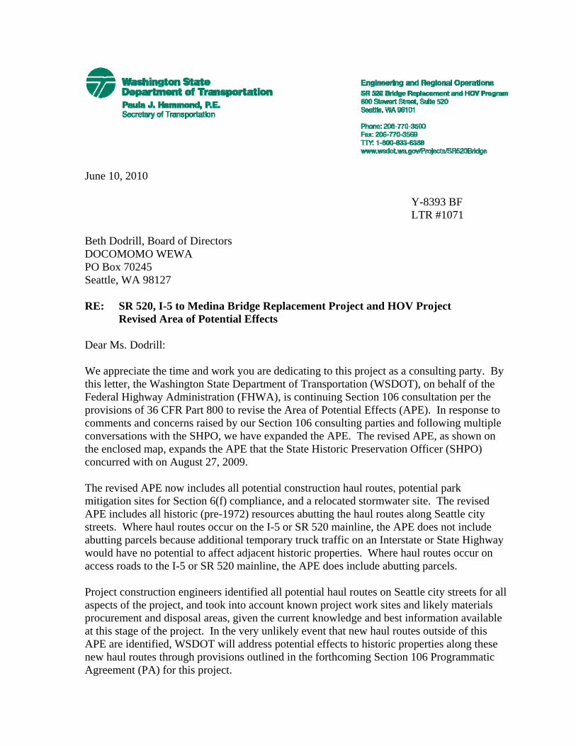
June 10, 2010 Y-8393 BF LTR #1071 Beth Dodrill, Board of Directors DOCOMOMO WEWA PO Box 70245 Seattle, WA 98127 RE: SR 520, I-5 to Medina Bridge Replacement Project and HOV Project
Revised Area of Potential Effects Dear Ms. Dodrill: We appreciate the time and work you are dedicating to this project as a consulting party. By this letter, the Washington State Department of Transportation (WSDOT), on behalf of the Federal Highway Administration (FHWA), is continuing Section 106 consultation per the provisions of 36 CFR Part 800 to revise the Area of Potential Effects (APE). In response to comments and concerns raised by our Section 106 consulting parties and following multiple conversations with the SHPO, we have expanded the APE. The revised APE, as shown on the enclosed map, expands the APE that the State Historic Preservation Officer (SHPO) concurred with on August 27, 2009. The revised APE now includes all potential construction haul routes, potential park mitigation sites for Section 6(f) compliance, and a relocated stormwater site. The revised APE includes all historic (pre-1972) resources abutting the haul routes along Seattle city streets. Where haul routes occur on the I-5 or SR 520 mainline, the APE does not include abutting parcels because additional temporary truck traffic on an Interstate or State Highway would have no potential to affect adjacent historic properties. Where haul routes occur on access roads to the I-5 or SR 520 mainline, the APE does include abutting parcels. Project construction engineers identified all potential haul routes on Seattle city streets for all aspects of the project, and took into account known project work sites and likely materials procurement and disposal areas, given the current knowledge and best information available at this stage of the project. In the very unlikely event that new haul routes outside of this APE are identified, WSDOT will address potential effects to historic properties along these new haul routes through provisions outlined in the forthcoming Section 106 Programmatic Agreement (PA) for this project.

Copies of the following letter were sent to the following individuals:
Date Subject From To Corresp. Ref. No.
7/21/2010 SR 520 Bridge Replacement and HOV Project, Seattle, King County, Invitation to Participate as a Section 106 Consulting Party
Julie Meredith SR 520 Program Director WSDOT
Pegeen Shean North Capitol Hill Neighborhood Association 2419 E Federal Avenue Seattle, WA 98102-4033
LTR #1496

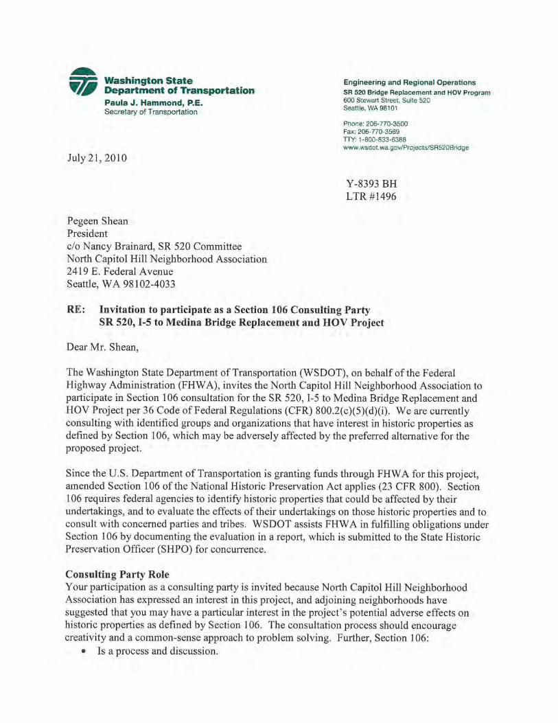
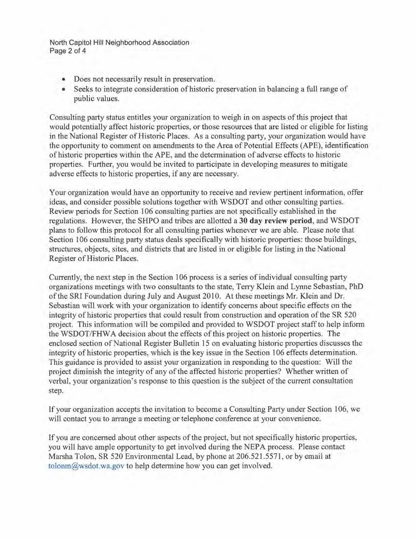
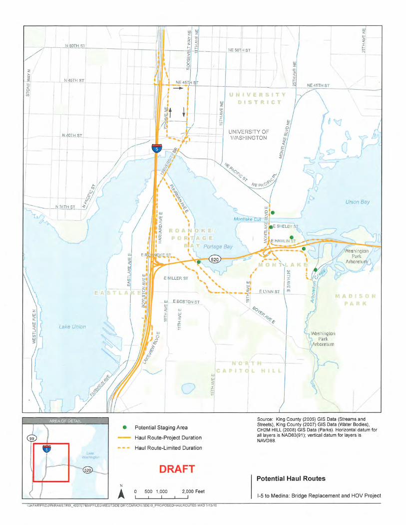
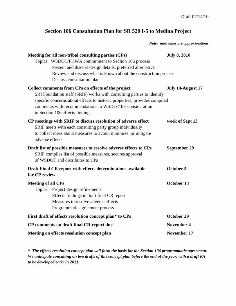
Draft 07/14/10
Section 106 Consultation Plan for SR 520 I-5 to Medina Project
Note: most dates are approximations
Meeting for all non-tribal consulting parties (CPs) July 8, 2010 Topics: WSDOT/FHWA commitment to Section 106 process Present and discuss design details, preferred alternative Review and discuss what is known about the construction process Discuss consultation plan
Collect comments from CPs on effects of the project July 14-August 17 SRI Foundation staff (SRIF) works with consulting parties to identify
specific concerns about effects to historic properties; provides compiled comments with recommendations to WSDOT for consideration
in Section 106 effects finding
CP meetings with SRIF to discuss resolution of adverse effect week of Sept 13 SRIF meets with each consulting party group individually to collect ideas about measures to avoid, minimize, or mitigate
adverse effects
Draft list of possible measures to resolve adverse effects to CPs September 29 SRIF compiles list of possible measures, secures approval of WSDOT and distributes to CPs
Draft Final CR report with effects determinations available October 5 for CP review
Meeting of all CPs October 13 Topics: Project design refinements Effects findings in draft final CR report Measures to resolve adverse effects Programmatic agreement process
First draft of effects resolution concept plan* to CPs October 29
CP comments on draft final CR report due November 4
Meeting on effects resolution concept plan November 17 * The effects resolution concept plan will form the basis for the Section 106 programmatic agreement. We anticipate consulting on two drafts of this concept plan before the end of the year, with a draft PA to be developed early in 2011.
VIII. HOW TO EVALUATE THEINTEGRITY OF A PROPERTY
INTRODUCTIONIntegrity is the ability of a prop-
erty to convey its significance. To belisted in the National Register ofHistoric Places, a property must notonly be shown to be significant underthe National Register criteria, but italso must have integrity. The evalua-tion of integrity is sometimes asubjective judgment, but it mustalways be grounded in an under-standing of a property's physicalfeatures and how they relate to itssignificance.
Historic properties either retainintegrity (this is, convey their signifi-cance) or they do not. Within theconcept of integrity, the NationalRegister criteria recognizes sevenaspects or qualities that, in variouscombinations, define integrity.
To retain historic integrity aproperty will always possess several,and usually most, of the aspects. Theretention of specific aspects of integ-rity is paramount for a property toconvey its significance. Determiningwhich of these aspects are mostimportant to a particular propertyrequires knowing why, where, andwhen the property is significant. Thefollowing sections define the sevenaspects and explain how they com-bine to produce integrity.
SEVEN ASPECTS OFINTEGRITY
• Location
• Design
• Setting
• Materials
• Workmanship
• Feeling
• Association
UNDERSTANDINGTHE ASPECTS OFINTEGRITY
LOCATION
Location is the place where thehistoric property was constructed orthe place where the historic eventoccurred. The relationship betweenthe property and its location is oftenimportant to understanding why theproperty was created or why some-thing happened. The actual locationof a historic property, complementedby its setting, is particularly importantin recapturing the sense of historicevents and persons. Except in rarecases, the relationship between aproperty and its historic associationsis destroyed if the property is moved.(See Criteria Consideration B in PartVII: How to Apply the Criteria Consider-ations, for the conditions under whicha moved property can be eligible.)
DESIGN
Design is the combination ofelements that create the form, plan,space, structure, and style of aproperty. It results from consciousdecisions made during the originalconception and planning of a prop-erty (or its significant alteration) andapplies to activities as diverse ascommunity planning, engineering,architecture, and landscape architec-ture. Design includes such elementsas organization of space, proportion,scale, technology, ornamentation, andmaterials.
A property's design reflects historicfunctions and technologies as well asaesthetics. It includes such consider-ations as the structural system;massing; arrangement of spaces;pattern of fenestration; textures andcolors of surface materials; type,amount, and style of ornamentaldetailing; and arrangement and typeof plantings in a designed landscape.
Design can also apply to districts,whether they are important primarilyfor historic association, architecturalvalue, information potential, or acombination thereof. For districtssignificant primarily for historicassociation or architectural value,design concerns more than just theindividual buildings or structureslocated within the boundaries. It alsoapplies to the way in which buildings,sites, or structures are related: forexample, spatial relationships be-tween major features; visual rhythmsin a streetscape or landscapeplantings; the layout and materials ofwalkways and roads; and the relation-ship of other features, such as statues,water fountains, and archeologicalsites.
44
SETTING
Setting is the physical environ-ment of a historic property. Whereaslocation refers to the specific placewhere a property was built or an eventoccurred, setting refers to the characterof the place in which the propertyplayed its historical role. It involveshow, not just where, the property issituated and its relationship to sur-rounding features and open space.
Setting often reflects the basicphysical conditions under which aproperty was built and the functions itwas intended to serve. In addition,the way in which a property is posi-tioned in its environment can reflectthe designer's concept of nature andaesthetic preferences.
The physical features that constitutethe setting of a historic property canbe either natural or manmade, includ-ing such elements as:
• Topographic features (a gorge orthe crest of a hill);
• Vegetation;
• Simple manmade features (pathsor fences); and
• Relationships between buildingsand other features or open space.
These features and their relation-ships should be examined not onlywithin the exact boundaries of theproperty, but also between the prop-erty and its surroundings. This isparticularly important for districts.
MATERIALS
Materials are the physical ele-ments that were combined or depos-ited during a particular period oftime and in a particular pattern orconfiguration to form a historicproperty. The choice and combinationof materials reveal the preferences ofthose who created the property andindicate the availability of particulartypes of materials and technologies.Indigenous materials are often thefocus of regional building traditionsand thereby help define an area'ssense of time and place.
A property must retain the keyexterior materials dating from theperiod of its historic significance. Ifthe property has been rehabilitated,the historic materials and significantfeatures must have been preserved.The property must also be an actualhistoric resource, not a recreation; a
recent structure fabricated to lookhistoric is not eligible. Likewise, aproperty whose historic features andmaterials have been lost and thenreconstructed is usually not eligible.(See Criteria Consideration E in PartVII: How to Apply the Criteria Consider-ations for the conditions under whicha reconstructed property can beeligible.)
WORKMANSHIP
Workmanship is the physicalevidence of the crafts of a particularculture or people during any givenperiod in history or prehistory. It isthe evidence of artisans' labor andskill in constructing or altering abuilding, structure, object, or site.Workmanship can apply to theproperty as a whole or to its indi-vidual components. It can be ex-pressed in vernacular methods ofconstruction and plain finishes or inhighly sophisticated configurationsand ornamental detailing. It can bebased on common traditions orinnovative period techniques.
Workmanship is important becauseit can furnish evidence of the technol-ogy of a craft, illustrate the aestheticprinciples of a historic or prehistoricperiod, and reveal individual, local,regional, or national applications ofboth technological practices andaesthetic principles. Examples ofworkmanship in historic buildingsinclude tooling, carving, painting,graining, turning, and joinery. Ex-amples of workmanship in prehistoriccontexts include Paleo-Indian clovisprojectile points; Archaic periodbeveled adzes; Hopewellian birdstonepipes; copper earspools and workedbone pendants; and Iroquoian effigypipes.
FEELING
Feeling is a property's expressionof the aesthetic or historic sense of aparticular period of time. It resultsfrom the presence of physical featuresthat, taken together, convey theproperty's historic character. Forexample, a rural historic districtretaining original design, materials,workmanship, and setting will relatethe feeling of agricultural life in the19th century. A grouping of prehis-toric petroglyphs, unmarred bygraffiti and intrusions and located onits original isolated bluff, can evoke asense of tribal spiritual life.
ASSOCIATION
Association is the direct linkbetween an important historic eventor person and a historic property. Aproperty retains association if it is theplace where the event or activityoccurred and is sufficiently intact toconvey that relationship to an ob-server. Like feeling, associationrequires the presence of physicalfeatures that convey a property'shistoric character. For example, aRevolutionary War battlefield whosenatural and manmade elements haveremained intact since the 18th centurywill retain its quality of associationwith the battle.
Because feeling and associationdepend on individual perceptions,their retention alone is never sufficientto support eligibility of a property forthe National Register.
ASSESSINGINTEGRITY INPROPERTIES
Integrity is based on significance:why, where, and when a property isimportant. Only after significance isfully established can you proceed tothe issue of integrity.
The steps in assessing integrity are:
• Define the essential physical fea-tures that must be present for aproperty to represent its signifi-cance.
• Determine whether the essentialphysical features are visibleenough to convey their signifi-cance.
• Determine whether the propertyneeds to be compared with simi-lar properties. And,
• Determine, based on the signifi-cance and essential physical fea-tures, which aspects of integrityare particularly vital to the prop-erty being nominated and if theyare present.
Ultimately, the question of integ-rity is answered by whether or not theproperty retains the identity forwhich it is significant.
45
DEFINING THE ESSENTIALPHYSICAL FEATURES
All properties change over time. Itis not necessary for a property toretain all its historic physical featuresor characteristics. The property mustretain, however, the essential physicalfeatures that enable it to convey itshistoric identity. The essentialphysical features are those featuresthat define both why a property issignificant (Applicable Criteria andAreas of Significance) and when it wassignificant (Periods of Significance).They are the features without which aproperty can no longer be identifiedas, for instance, a late 19th centurydairy barn or an early 20th centurycommercial district.
CRITERIA A AND B
A property that is significant for itshistoric association is eligible if itretains the essential physical featuresthat made up its character or appear-ance during the period of its associa-tion with the important event, histori-cal pattern, or person(s). If theproperty is a site (such as a treaty site)where there are no material culturalremains, the setting must be intact.
Archeological sites eligible underCriteria A and B must be in overallgood condition with excellent preser-vation of features, artifacts, andspatial relationships to the extent thatthese remains are able to conveyimportant associations with events orpersons.
CRITERION C
A property important for illustrat-ing a particular architectural style orconstruction technique must retainmost of the physical features thatconstitute that style or technique. Aproperty that has lost some historicmaterials or details can be eligible if itretains the majority of the featuresthat illustrate its style in terms of themassing, spatial relationships, propor-tion, pattern of windows and doors,texture of materials, and ornamenta-tion. The property is not eligible,however, if it retains some basicfeatures conveying massing but haslost the majority of the features thatonce characterized its style.
Archeological sites eligible underCriterion C must be in overall goodcondition with excellent preservation
of features, artifacts, and spatialrelationships to the extent that theseremains are able to illustrate a sitetype, time period, method of construc-tion, or work of a master.
CRITERION D
For properties eligible underCriterion D, including archeologicalsites and standing structures studiedfor their information potential, lessattention is given to their overallcondition, than it they were beingconsidered under Criteria A, B, or C.Archeological sites, in particular, donot exist today exactly as they wereformed. There are always culturaland natural processes that alter thedeposited materials and their spatialrelationships.
For properties eligible underCriterion D, integrity is based uponthe property's potential to yieldspecific data that addresses importantresearch questions, such as thoseidentified in the historic contextdocumentation in the StatewideComprehensive Preservation Plan orin the research design for projectsmeeting the Secretary of the Interior'sStandards for Archeological Documenta-tion.
INTERIORS
Some historic buildings are virtu-ally defined by their exteriors, andtheir contribution to the built environ-ment can be appreciated even if theirinteriors are not accessible. Examplesof this would include early examplesof steel-framed skyscraper construc-tion. The great advance in Americantechnology and engineering made bythese buildings can be read from theoutside. The change in Americanpopular taste during the 19th century,from the symmetry and simplicity ofarchitectural styles based on classicalprecedents, to the expressions of HighVictorian styles, with their combina-tion of textures, colors, and asym-metrical forms, is readily apparentfrom the exteriors of these buildings.
Other buildings "are" interiors.The Cleveland Arcade, that soaring19th century glass-covered shoppingarea, can only be appreciated from theinside. Other buildings in thiscategory would be the great coveredtrain sheds of the 19th century.
In some cases the loss of an interiorwill disqualify properties from listing
in the National Register—a historicconcert hall noted for the beauty of itsauditorium and its fine acousticqualities would be the type of prop-erty that if it were to lose its interior,it would lose its value as a historicresource. In other cases, the over-arching significance of a property'sexterior can overcome the adverseeffect of the loss of an interior.
In borderline cases particularattention is paid to the significance ofthe property and the remaininghistoric features.
HISTORIC DISTRICTS
For a district to retain integrity as awhole, the majority of the compo-nents that make up the district'shistoric character must possessintegrity even if they are individuallyundistinguished. In addition, therelationships among the district'scomponents must be substantiallyunchanged since the period of signifi-cance.
When evaluating the impact ofintrusions upon the district's integ-rity, take into consideration therelative number, size, scale, design,and location of the components thatdo not contribute to the significance.A district is not eligible if it containsso many alterations or new intrusionsthat it no longer conveys the sense ofa historic environment.
A component of a district cannotcontribute to the significance if:
• it has been substantially alteredsince the period of the district'ssignificance or
• it does not share the historic asso-ciations of the district.
VISIBILITY OF PHYSICALFEATURES
Properties eligible under CriteriaA, B, and C must not only retain theiressential physical features, but thefeatures must be visible enough toconvey their significance. This meansthat even if a property is physicallyintact, its integrity is questionable ifits significant features are concealedunder modern construction. Archeo-logical properties are often theexception to this; by nature theyusually do not require visible featuresto convey their significance.
46
NON-HISTORIC EXTERIORS SUNKEN VESSELS
If the historic exterior buildingmaterial is covered by non-historicmaterial (such as modern siding), theproperty can still be eligible if thesignificant form, features, and detail-ing are not obscured. If a property'sexterior is covered by a non-historicfalse-front or curtain wall, the prop-erty will not qualify under Criteria A,B, or C, because it does not retain thevisual quality necessary to conveyhistoric or architectural significance.Such a property also cannot beconsidered a contributing element in ahistoric district, because it does notadd to the district's sense of time andplace. If the false front, curtain wall,or non-historic siding is removed andthe original building materials areintact, then the property's integritycan be re-evaluated.
PROPERTY CONTAINEDWITHIN ANOTHERPROPERTY
Some properties contain an earlierstructure that formed the nucleus forlater construction. The exteriorproperty, if not eligible in its ownright, can qualify on the basis of theinterior property only if the interiorproperty can yield significant infor-mation about a specific constructiontechnique or material, such asrammed earth or tabby. The interiorproperty cannot be used as the basisfor eligibility if it has been so alteredthat it no longer contains the featuresthat could provide important infor-mation, or if the presence of impor-tant information cannot be demon-strated.
A sunken vessel can be eligibleunder Criterion C as embodying thedistinctive characteristics of a methodof construction if it is structurallyintact. A deteriorated sunken vessel,no longer structurally intact, can beeligible under Criterion D if theremains of either the vessel or itscontents is capable of yielding signifi-cant information. For further infor-mation, refer to National RegisterBulletin: Nominating Historic Vesselsand Shipwrecks to the National Registerof Historic Places.
Natural FeaturesA natural feature that is associated
with a historic event or trend, such asa rock formation that served as a trailmarker during westward expansion,must retain its historic appearance,unobscured by modern constructionor landfill. Otherwise it is not eli-gible, even though it remains intact.
COMPARING SIMILARPROPERTIES
For some properties, comparisonwith similar properties should beconsidered during the evaluation ofintegrity. Such comparison may beimportant in deciding what physicalfeatures are essential to properties ofthat type. In instances where it hasnot been determined what physicalfeatures a property must possess inorder for it to reflect the significanceof a historic context, comparison withsimilar properties should be under-taken during the evaluation of integ-rity. This situation arises whenscholarly work has not been done on aparticular property type or whensurviving examples of a property typeare extremely rare. (See ComparingRelated Properties in Part V: How toEvaluate a Property within its HistoricContext.)
RARE EXAMPLES OF APROPERTY TYPE
Comparative information isparticularly important to considerwhen evaluating the integrity of aproperty that is a rare survivingexample of its type. The propertymust have the essential physicalfeatures that enable it to convey itshistoric character or information. Therarity and poor condition, however, ofother extant examples of the type mayjustify accepting a greater degree ofalteration or fewer features, providedthat enough of the property survivesfor it to be a significant resource.
Eligible
• A one-room schoolhouse thathas had all original exteriorsiding replaced and a replace-ment roof that does not exactlyreplicate the original roof pro-file can be eligible if the otherextant rare examples have re-ceived an even greater degreeof alteration, such as the sub-division of the original one-room plan.
Not Eligible
• A mill site contains informa-tion on how site patterning re-flects historic functional re-quirements, but parts of thesite have been destroyed. Thesite is not eligible for its infor-mation potential if a compari-son of other mill sites revealsmore intact properties withcomplete information.
47
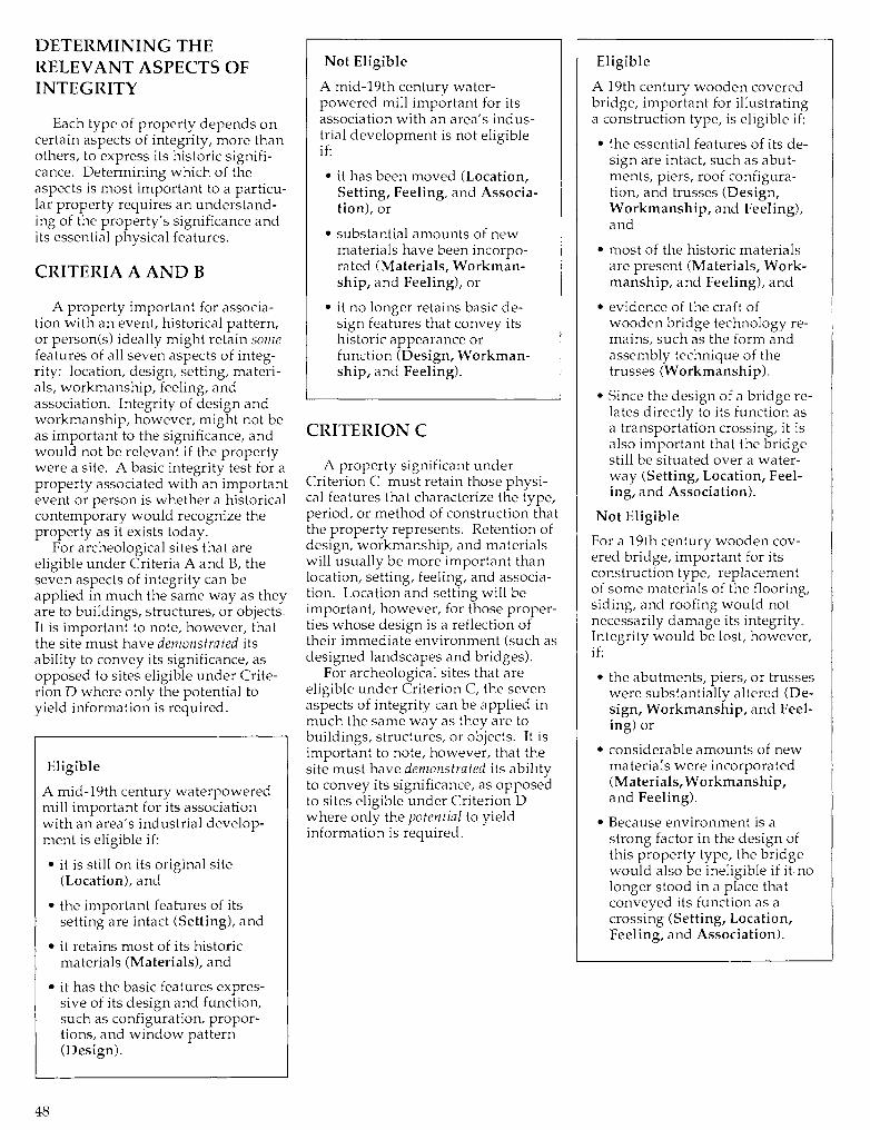
DETERMINING THERELEVANT ASPECTS OFINTEGRITY
Each type of property depends oncertain aspects of integrity, more thanothers, to express its historic signifi-cance. Determining which of theaspects is most important to a particu-lar property requires an understand-ing of the property's significance andits essential physical features.
CRITERIA A AND B
A property important for associa-tion with an event, historical pattern,or person(s) ideally might retain somefeatures of all seven aspects of integ-rity: location, design, setting, materi-als, workmanship, feeling, andassociation. Integrity of design andworkmanship, however, might not beas important to the significance, andwould not be relevant if the propertywere a site. A basic integrity test for aproperty associated with an importantevent or person is whether a historicalcontemporary would recognize theproperty as it exists today.
For archeological sites that areeligible under Criteria A and B, theseven aspects of integrity can beapplied in much the same way as theyare to buildings, structures, or objects.It is important to note, however, thatthe site must have demonstrated itsability to convey its significance, asopposed to sites eligible under Crite-rion D where only the potential toyield information is required.
Eligible
A mid-19th century waterpoweredmill important for its associationwith an area's industrial develop-ment is eligible if:
• it is still on its original site(Location), and
• the important features of itssetting are intact (Setting), and
• it retains most of its historicmaterials (Materials), and
• it has the basic features expres-sive of its design and function,such as configuration, propor-tions, and window pattern(Design).
Not Eligible
A mid-19th century water-powered mill important for itsassociation with an area's indus-trial development is not eligibleif:
• it has been moved (Location,Setting, Feeling, and Associa-tion), or
• substantial amounts of newmaterials have been incorpo-rated (Materials, Workman-ship, and Feeling), or
• it no longer retains basic de-sign features that convey itshistoric appearance orfunction (Design, Workman-ship, and Feeling).
CRITERION C
A property significant underCriterion C must retain those physi-cal features that characterize the type,period, or method of construction thatthe property represents. Retention ofdesign, workmanship, and materialswill usually be more important thanlocation, setting, feeling, and associa-tion. Location and setting will beimportant, however, for those proper-ties whose design is a reflection oftheir immediate environment (such asdesigned landscapes and bridges).
For archeological sites that areeligible under Criterion C, the sevenaspects of integrity can be applied inmuch the same way as they are tobuildings, structures, or objects. It isimportant to note, however, that thesite must have demonstrated its abilityto convey its significance, as opposedto sites eligible under Criterion Dwhere only the potential to yieldinformation is required.
Eligible
A 19th century wooden coveredbridge, important for illustratinga construction type, is eligible if:
• the essential features of its de-sign are intact, such as abut-ments, piers, roof configura-tion, and trusses (Design,Workmanship, and Feeling),and
• most of the historic materialsare present (Materials, Work-manship, and Feeling), and
• evidence of the craft ofwooden bridge technology re-mains, such as the form andassembly technique of thetrusses (Workmanship).
• Since the design of a bridge re-lates directly to its function asa transportation crossing, it isalso important that the bridgestill be situated over a water-way (Setting, Location, Feel-ing, and Association).
Not Eligible
For a 19th century wooden cov-ered bridge, important for itsconstruction type, replacementof some materials of the flooring,siding, and roofing would notnecessarily damage its integrity.Integrity would be lost, however,if:
• the abutments, piers, or trusseswere substantially altered (De-sign, Workmanship, and Feel-ing) or
• considerable amounts of newmaterials were incorporated(Materials, Workmanship,and Feeling).
• Because environment is astrong factor in the design ofthis property type, the bridgewould also be ineligible if it nolonger stood in a place thatconveyed its function as acrossing (Setting, Location,Feeling, and Association).
48
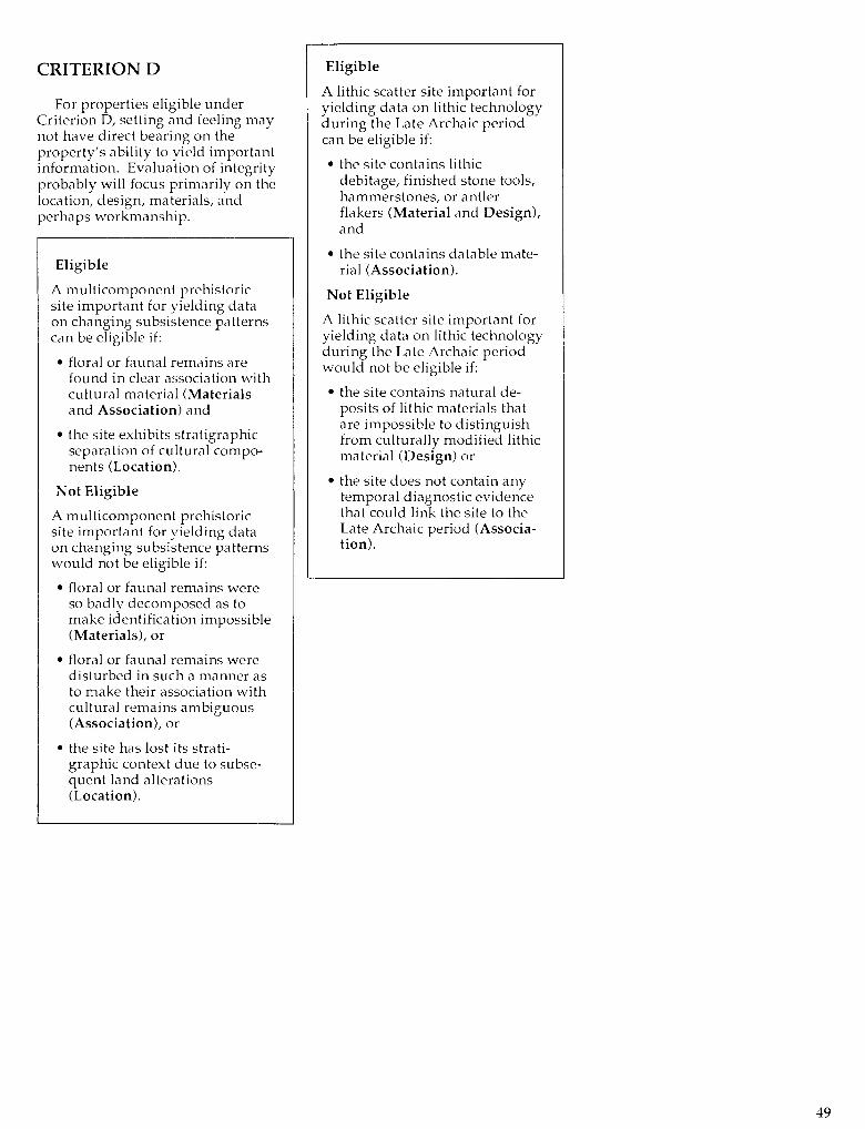
CRITERION D
For properties eligible underCriterion D, setting and feeling maynot have direct bearing on theproperty's ability to yield importantinformation. Evaluation of integrityprobably will focus primarily on thelocation, design, materials, andperhaps workmanship.
Eligible
A multicomponent prehistoricsite important for yielding dataon changing subsistence patternscan be eligible if:
• floral or faunal remains arefound in clear association withcultural material (Materialsand Association) and
• the site exhibits stratigraphicseparation of cultural compo-nents (Location).
Not Eligible
A multicomponent prehistoricsite important for yielding dataon changing subsistence patternswould not be eligible if:
• floral or faunal remains wereso badly decomposed as tomake identification impossible(Materials), or
• floral or faunal remains weredisturbed in such a manner asto make their association withcultural remains ambiguous(Association), or
• the site has lost its strati-graphic context due to subse-quent land alterations(Location).
Eligible
A lithic scatter site important foryielding data on lithic technologyduring the Late Archaic periodcan be eligible if:
• the site contains lithicdebitage, finished stone tools,hammerstones, or antlerflakers (Material and Design),and
• the site contains datable mate-rial (Association).
Not Eligible
A lithic scatter site important foryielding data on lithic technologyduring the Late Archaic periodwould not be eligible if:
• the site contains natural de-posits of lithic materials thatare impossible to distinguishfrom culturally modified lithicmaterial (Design) or
• the site does not contain anytemporal diagnostic evidencethat could link the site to theLate Archaic period (Associa-tion).
49
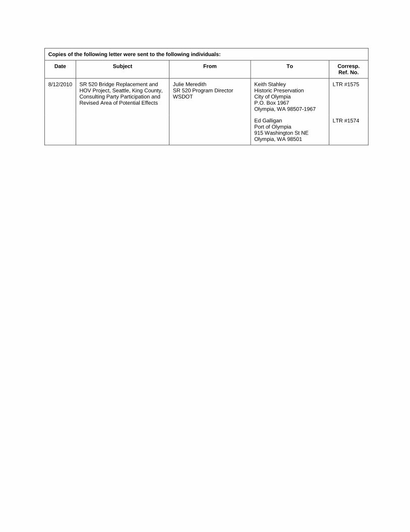
Copies of the following letter were sent to the following individuals:
Date Subject From To Corresp. Ref. No.
8/12/2010 SR 520 Bridge Replacement and HOV Project, Seattle, King County, Consulting Party Participation and Revised Area of Potential Effects
Julie Meredith SR 520 Program Director WSDOT
Keith Stahley Historic Preservation City of Olympia P.O. Box 1967 Olympia, WA 98507-1967
LTR #1575
Ed Galligan Port of Olympia 915 Washington St NE Olympia, WA 98501
LTR #1574