Embed Size (px)
Citation preview

State Planning Policy – state interest guidance material
Liveable communities
July 2017

State interest guidance material – Liveable communities
The State of Queensland, July 2017. Published by the Department of Infrastructure, Local Government and Planning, 1 William Street, Brisbane Qld 4000, Australia.
Licence: This work is licensed under the Creative Commons CC BY 4.0 Australia licence. To view a copy of the licence, visit http://creativecommons.org/licenses/by/4.0/.
Enquiries about this licence or any copyright issues can be directed to the department by email to [email protected] or in writing to PO Box 15009, City East Qld 4002.
Attribution: The State of Queensland, Department of Infrastructure, Local Government and Planning.
The Queensland Government supports and encourages the dissemination and exchange of information. However, copyright protects this publication. The State of Queensland has no objection to this material being reproduced, made available online or electronically but only if it is recognised as the owner of the copyright and this material remains unaltered.
The Queensland Government is committed to providing accessible services to Queenslanders of all cultural and linguistic backgrounds. If you have difficulty understanding this publication and need a translator, please call the Translating and Interpreting Service (TIS National) on 131 450 and ask them to telephone the Queensland Department of Infrastructure, Local Government and Planning on 13 QGOV (13 74 68).
Disclaimer: While every care has been taken in preparing this publication, the State of Queensland accepts no
responsibility for decisions or actions taken as a result of any data, information, statement or advice, expressed or implied, contained within. To the best of our knowledge, the content was correct at the time of publishing. Any references to legislation are not an interpretation of the law. They are to be used as a guide only. The information in this publication is general and does not take into account individual circumstances or situations. Where appropriate, independent legal advice should be sought. An electronic copy of this report is available on the Department of Infrastructure, Local Government and Planning’s website at www.dilgp.qld.gov.au.

State interest guidance material – Liveable communities
Contents Using the SPP state interest guidance material ................................................. 1 Part 1: Understanding the state interest ............................................................. 3 Part 2: Integrating the state interest policies ...................................................... 5 Part 3: Mapping ............................................................................................... 13 Part 4: Applying assessment benchmarks ....................................................... 14 Part 5: Example planning scheme provisions ................................................... 16 Part 6: Supporting information ......................................................................... 21

1
State interest guidance material – Liveable communities
Using the SPP state interest guidance material The Queensland Government established the State Planning Policy (SPP) to define the matters of state interest in land-use planning and development. State interests in the SPP consist of a state interest statement, state interest policies and, where applicable, assessment benchmarks. This guidance material has been prepared to support the implementation of the SPP and the interpretation of the Liveable communities state interest. Although the SPP broadly applies to a range of activities undertaken by state and local governments, the guidance material is particularly focused on assisting local governments when making or amending a local planning instrument and when applying the assessment benchmarks (to the extent relevant). The SPP does not prioritise one state interest over another, providing flexibility for decision makers to respond to specific regional and local circumstances. This allows for the state interests to be considered in their entirety rather than as individual or separate priorities. State interests are to be considered in the context of the guiding principles in the SPP, which promote an outcome focused, integrated, efficient, positive and accountable planning system. The SPP guidance material is intended to be read in conjunction with the SPP and the relevant state interest. The SPP guidance material is not statutory in its effect and does not contain any new policy. It is not mandatory for local governments to use the guidance material but it is provided to assist with the interpretation and application of the state interest policies and the assessment benchmarks contained in the SPP.

2
State interest guidance material – Liveable communities
The SPP guidance material is structured as follows: Part 1: Understanding the state interest – This section briefly explains why a particular matter is a matter of state interest, describes the purpose of the relevant state interest statement and defines the core concepts associated with the state interest. Part 2: Integrating the state interest policies – This section provides background and further explanation for each of the state interest policies defined in the SPP. It also provides examples and options regarding how to appropriately integrate each state interest policy into a local planning instrument. Part 3: Mapping – This section identifies and explains the mapping layers contained in the SPP Interactive Mapping System (IMS) relevant to a particular state interest. It also clarifies how a local government can locally refine state mapping in certain instances and outlines where online mapping for the state interest can be accessed (if relevant). Part 4: Applying assessment benchmarks – In accordance with the Planning Regulation, an assessment manager or referral agency must have regard to the SPP when assessing a development application. For some state interests, there are also specific assessment benchmarks that must be used by a local government for development assessment. This section outlines the development applications to which the assessment benchmarks apply and how a development application may demonstrate compliance with these benchmarks, to the extent that these are relevant. The assessment benchmarks contained in this section will apply to assessable development in addition to any assessment benchmarks contained in a local planning instrument, to the extent of any inconsistency. Part 5: Example planning scheme provisions – This section provides example planning scheme provisions that a local government may choose to adopt, or to adapt, when making or amending a local planning instrument. It is important to note that the example planning scheme provisions provided may only be in relation to a particular aspect of a state interest, rather than addressing all of the particular state interest policy requirements. Part 6: Supporting information – This section provides a list of technical resources that a local government may wish to consider when making or amending a planning scheme. This section also provides a glossary of terms and acronyms used throughout the SPP guidance material. Where text in this guidance material is in a coloured text box, it is an excerpt from the SPP and is either the state interest statement, state interest policy or the assessment benchmarks applicable to the Liveable communities state interest. Any queries related to the SPP guidance material or the SPP should be sent to [email protected].

3
State interest guidance material – Liveable communities
Pa
rt 2
Inte
gra
ting
the s
tate
inte
rest p
olic
ies
Part 1: Understanding the state interest
Background
The liveability of communities is of particular interest to the Queensland Government because it directly influences quality of life and wellbeing. A range of factors are in play, including the characteristics of the built and natural environments; access to employment, goods and services, and open space; and our resilience to natural hazards and the effects of climate change. As the population of our cities, towns and regions change, and the socio-economic and demographic profiles reflect that change, the importance of attractive, healthy, safe, accessible and inclusive places and spaces increases.
Core concepts
Liveable communities Liveable communities are those that are vibrant, prosperous, sustainable, diverse, inclusive, accessible, attractive, healthy and safe for all community members. Creating well-functioning, successful communities requires a long-term commitment to a combination of land-use planning, infrastructure investment, design and community development strategies. Planning and designing for liveable communities offers benefits to residents, businesses, workers and visitors to these communities, while advancing the health and prosperity of the state. Planning for a liveable community, including making allowances for future growth, will help to ensure the long-term success of the community. Liveable communities are most successful when they are inclusive and all community members feel a strong sense of place and belonging. The success of communities is advanced where communities are well connected to surrounding neighbourhoods, regions and towns. Liveable communities are those that also cater for the diverse needs of all people and abilities in the community, including people with disabilities or restricted mobility, seniors, and people with young children. High-quality urban design and place-making The quality of our suburbs, towns and cities has a significant impact on everyday life. People are strongly influenced by the physical and natural environment with the form, shape and pattern of land use providing the platform for human interaction and behaviour. The scale, intensity, legibility and aesthetics of places and spaces can have a positive influence on how well people interact with, access, and connect to, the place. Well-planned neighbourhoods can support safe, socially cohesive and inclusive communities and healthy lifestyles. To enhance liveability, built and natural environments can be innovatively designed, or transformed, through the well-planned placement and design of buildings, pedestrian and cyclist access, road and street networks, sport and recreation facilities, and public open spaces. Features such as shade, shelter, seating and footpaths can encourage walking and contribute to the accessibility of public transport, public places and local recreational
State interest statement Liveable, well-designed and serviced communities are delivered to support wellbeing and enhance quality of life.

4
State interest guidance material – Liveable communities
Pa
rt 2
Inte
gra
ting
the s
tate
inte
rest p
olic
ies
facilities for all people of all ages and abilities. It is important that quality open space offers a series of diverse spaces that accommodate a range of different uses, users and needs, and allows for different activities at different times of the day and seasons. Buildings, streets and spaces that are designed to work with and respond to the local climate create places and spaces that are resource efficient and deliver climate-resilient, cost-effective and comfortable living. Development that adopts a passive design approach, using natural elements such as sunlight and breezes to heat, cool and light buildings, reduces or eliminates the need for mechanical and electrical systems such as air conditioning. Land-use planning plays an important role in responding to the physical constraints that a changing climate presents. This can be achieved through appropriate zoning of land, siting and orientation of buildings, and through quality urban design principles that are sensitive to the local climate and local context. This ensures that potential future climate vulnerabilities are mitigated or minimised. By supporting well-designed higher density development in appropriate locations, planning can also facilitate and improve public and active transport usage, which improves community health and wellbeing and helps to reduce carbon emissions.
Accessible and connected places and spaces Liveable communities are easy to access and move around in, and are well connected to other destinations through a range of travel modes including public transport, walking, cycling and private vehicles. Connectivity is a facilitator of access by providing clear and legible routes between key destinations for all travel modes. Urban form plays an integral role in promoting accessibility and sustainability. Neighbourhoods that have higher residential densities, good access to destinations, connected street networks and quality pedestrian-oriented urban design produce substantial health benefits to communities.
Community facilities and services Community facilities and services (e.g. schools and childcare centres), as well as the social networks they help foster, are fundamental to community health and wellbeing. Community facilities and services encourage people to take part in community life, build a sense of place, reduce social isolation and help meet basic individual and family needs. It is important that community facilities and services are available to communities early in their formation to support the practical needs of residents and workers and reduce the need to travel long distances. The infrastructure should be designed to be inclusive for all people of all ages, abilities and stages of life (e.g. people with disability or restricted mobility, seniors and people with young children). It should also include a focus on groups with special needs (e.g. Indigenous or culturally and linguistically diverse people).
Affordable living Affordable living refers to the total cost of living. It covers all living costs, including the dwelling cost or cost of renting a dwelling, and the cost of accessing employment, services, open space, family and friends. The planning system can help address affordable living through appropriate planning controls that govern factors such as location, size, design and siting of housing, development, services and facilities. Complete communities Complete communities are communities where residents have good access locally to a range of everyday goods, services and employment opportunities. Complete communities support economic and social opportunity without residents having to commute long distances to access the basic elements that help sustain a community.

5
State interest guidance material – Liveable communities
Pa
rt 2
Inte
gra
ting
the s
tate
inte
rest p
olic
ies
PA
RT
B
Part 2: Integrating the state interest policies When making or amending a local planning instrument, each local government is required to consider all state interests in the SPP and appropriately integrate those state interests applicable to their local area. Appropriately integrating a state interest requires all state interest policies to be considered by a local government, but it does not necessarily mean a local government must address each and every state interest policy when making or amending a local planning instrument. For example, if a local government needs to balance competing state interests in a local planning instrument, it may not be possible to address all policies. This balancing of state interests may mean that the planning scheme preferences one state interest policy over another. This outcome will be considered as part of the state interest review. Ministerial approval means the approach taken by the local government in balancing the state interest polices is endorsed by the state. This section provides examples for how to appropriately integrate each state interest policy for the Liveable communities state interest.
Background Quality urban design and place-making increases the quality of life and wellbeing of communities and encourages residents, workers and visitors to the area. Creating attractive, sustainable, adaptable, accessible, functional and legible places and spaces is essential to promoting liveable and sustainable communities. How well communities are designed will influence personal safety and security, mobility and modes of transportation, access to shops, community facilities and schools. Quality urban design and place-making can contribute to affordable living outcomes and create flexibility within the built environment to accommodate individual needs and preferences as they change over time. Memorable places with their own identity reflect the distinctive qualities of their physical setting, heritage and community values. Buildings, streets and spaces create the opportunity to reflect character by identifying landscape, heritage and cultural assets worthy of protection, and by working with the local community to enhance local identity. Heritage buildings and areas of historical importance may act as a focal point to a precinct or neighbourhood and help to establish or maintain local identity and stimulate community spirit.
State interest policy (1) Built and natural environment: High quality urban design and place making outcomes are facilitated and promote: (a) affordable living and sustainable and complete communities (b) attractive, adaptable, accessible and inclusive built environments (c) personal safety and security (d) functional, accessible, legible and connected spaces (e) community identity through considering local features, character,
needs and aspirations.

6
State interest guidance material – Liveable communities
Pa
rt 2
Inte
gra
ting
the s
tate
inte
rest p
olic
ies
Land-use planning can influence urban form to support development that is adaptable, accessible and sustainable. It influences the siting of development to ensure it is appropriate for the local climate and community needs now and into the future.
How to appropriately integrate the policy
1.1 Ensure strategic outcomes and other relevant planning scheme provisions support development outcomes that maximise local accessibility to places of employment, education, recreation and other community facilities and services.
1.2 Include measures in the planning scheme to facilitate high-quality urban design and place-making outcomes in the built and natural environment that promote highly attractive, accessible, adaptive, functional, legible and connected places and spaces.
1.3 Include planning scheme provisions to ensure that development is designed to accommodate new uses and users in the long term and adapt to changing social, economic and environmental conditions.
1.4 Ensure strategic outcomes support development that is responsive to the local climate by providing natural shade, cooling and lighting, indoor and outdoor living spaces and public places.
1.5 Include contemporary approaches to crime prevention that address design and social development principles, including social inclusion, legibility and territoriality of space and community activation, as articulated in crime prevention through environmental design (CPTED) principles.
1.6 Incorporate planning scheme provisions that require development to protect, retain, respect and highlight local character and history where appropriate. These measures could:
• consider including provisions regarding streetscaping and public areas that support development that responds to local character and promotes legibility and amenity
• recognise and encourage local character and protect items, buildings and areas that demonstrate local heritage value.
State interest policy (2) Built and natural environment: Vibrant places and spaces, and diverse communities that meet lifestyle needs are facilitated by: (a) good neighbourhood planning and centre design (b) a mix of land uses that meet the diverse demographic, social, cultural,
economic and lifestyle needs of the community (c) consolidating urban development in and around existing settlements (d) higher density development in accessible and well-serviced locations (e) efficient use of established infrastructure and services (f) supporting a range of formal and informal sporting, recreational and
community activities.

7
State interest guidance material – Liveable communities
Pa
rt 2
Inte
gra
ting
the s
tate
inte
rest p
olic
ies
Background Vibrant places and spaces require a rich mix of building types, quality public realm design and contemporary architectural solutions to support sustainable population densities, encourage diversity and assist in creating a strong sense of local identity. To ensure the daily needs of different communities can be met, it is important that buildings, streets and spaces are designed to be inclusive, diverse and provide for a range of land uses and supporting infrastructure and services. A vibrant community accommodates diversity in housing, employment and a range of complementary uses (e.g. retail, offices, services, education, dining, entertainment and community and health facilities), which allows people to satisfy many of their daily needs in one place. Land-use planning plays a pivotal role in managing compatibility between different uses and activities in communities while promoting residential amenity, after-hours safety and access to appropriate services. Successful communities include centres of activity that accommodate employment as well as complementary activities such as businesses, services, and facilities for employment, cultural and entertainment facilities, health, education and recreational services. These facilities and services are usually clustered together and are co-located with higher density residential development. The clustering of activities in centres reduces the need for separate trips, makes it easier to provide access by public transport and active transport modes, and encourages social and economic interaction. Vibrant communities require a range of sporting, recreational, and community activities. These can be provided through specific facilities that require active participation, as well as places that encourage passive participation and informal activities.
How to appropriately integrate the policy
2.1 Include provisions for neighbourhood design that reflect the local needs and character of a neighbourhood and integrate appropriately with surrounding neighbourhoods.
2.2 Consider the use of precincts or local plans to accentuate the character and identity of a community through tailored planning provisions.
2.3 Include zoning provisions that allow for flexible and adaptive retail and commercial spaces, cafés and public places to be located within all neighbourhoods, precincts and centres.
2.4 Identify areas that can suitably accommodate infill development and redevelopment opportunities, particularly in accessible and well-serviced locations where existing infrastructure and services are underused. Ensure planning scheme provisions encourage and facilitate infill development and redevelopment opportunities in these areas.
2.5 Include planning scheme provisions that encourage and promote higher density development in areas that support high levels of public transport.
2.6 Include planning scheme provisions that support centres as meeting places and local focal points for the community.
2.7 Ensure levels of assessment and planning requirements support a range of formal and informal sporting, recreation and community activities in neighbourhoods and any district or local area planning.
8
State interest guidance material – Liveable communities
Pa
rt 2
Inte
gra
ting
the s
tate
inte
rest p
olic
ies
Background
The natural environment and landscape character of an area is important in contributing to community identity and sense of place. Development that is designed to have regard to local landscape characteristics, the natural environment, important cultural landscapes and areas of high scenic amenity will contribute positively to the visual experience of a place, social cohesion and overall liveability. It is important that planning for public open space achieves a connected network of diverse, accessible, quality parks and recreational facilities that contribute to the attractiveness and vitality of the local area. Access to the natural environment and open space can encourage a more active lifestyle, improve perceived general health, reduce stress levels, and enhance social outcomes.
How to appropriately integrate the policy
3.1 Consider measures in the planning scheme that encourage new development to respects and responds to local context, physical features, cultural significance, views and vistas, and connections to existing facilities and movement networks.
3.2 Identify local landscape, heritage and cultural assets of value to the local community and appropriately integrate new development.
3.3 Consider identifying areas of high scenic amenity and important views and vistas and include provisions to protect these areas from development that would detract from these values. This could include identifying the strategic outcomes (including mapping) and inclusion of development requirements in zone codes/local plans or an overlay.
3.4 Incorporate measures that maximise the benefits of open space, such as:
• protection of natural areas of high natural and scenic amenity
• provision of quality public spaces in new developments
• optimisation of the visual amenity of open spaces through appropriate design and siting.
3.5 Include provisions that support the development of a connected network of flexible and versatile open spaces that promote diverse activities and experiences and connect natural and recreational spaces in order to expand their use and accessibility, as well as encourage more physical activity.
3.6 Ensure adequate provision of open-space areas (including local, district and regional open spaces) to serve the different needs of the community. These areas can be spatially represented within appropriate planning scheme maps.
State interest policy (3) Built and natural environment: Development is designed to: (a) value and nurture local landscape character and the natural
environment (b) maintain or enhance important cultural landscapes and areas of
high scenic amenity, including important views and vistas that contribute to natural and visual amenity
(c) maintain or enhance opportunities for public access and use of the natural environment.

9
State interest guidance material – Liveable communities
Pa
rt 2
Inte
gra
ting
the s
tate
inte
rest p
olic
ies
3.7 Consider an open-space strategy and incorporate the provisions of this strategy into the strategic outcomes of planning schemes, land-use planning and open-space provisions and codes.
3.8 Include provisions so that development does not adversely impact on public access and use of the natural environment.
3.9 Include provisions in the appropriate development code or zone code so that park embellishments are provided to a level and quantity consistent with the intended function and level of use.
3.10 Include provisions so that equitable access for people with disability or restricted mobility, seniors and people with young children is provided.
Background
The provision of pedestrian, cycling and public transport infrastructure and the connectivity of these networks between and within suburbs/localities are important to the success of a community. Access to quality transport networks can increase transport efficiency, productivity, safety and quality of life, as well as contribute to affordable living, which is an important component of a liveable community. Providing for effective pedestrian, cycling and public transport infrastructure requires a permeable street network that is accessible to all users and has the capacity for multiple transport modes. The planning system can encourage and promote active transport by prioritising pedestrian and cycling through appropriate street layout and design.
How to appropriately integrate the policy
4.1 Include strategic outcomes within the planning scheme to promote a coherent and legible streetscape that is oriented to pedestrian and cyclist movement and offers safety, connectivity, legibility and permeability. Ensure code provisions support the strategic outcomes.
4.2 Include provisions that provide a highly-interconnected street layout with shorter block lengths and a grid pattern.
4.3 Include code provisions to support the delivery of direct, attractive and safe pedestrian, cycle and public transport links. This should prioritise the provision or improvement of links to public transport facilities, as well as between neighbourhoods and employment centres and community facilities. Local plans can be used to identify priority routes.
4.4 Encourage appropriate mixed use and higher density developments near transport nodes.
4.5 Include provisions so that equitable access for people with disability or restricted mobility is provided.
State interest policy (4) Infrastructure and services: Connected pedestrian, cycling and public transport infrastructure networks are facilitated and provided.

10
State interest guidance material – Liveable communities
Pa
rt 2
Inte
gra
ting
the s
tate
inte
rest p
olic
ies
PA
RT
B
4.6 Include provisions that deliver a range of street and space scales that easily and comfortably accommodate the needs of all users – pedestrians first, followed by cyclists and then vehicles.
4.7 Include code provisions to support the provision of end-of-trip facilities, such as secure storage for bicycles, lockers, showers and change facilities at destinations.
Background
Provision of adequate infrastructure and services to meet the current and future needs of a community is the cornerstone of a prosperous economy that supports community health and wellbeing. Best practice infrastructure planning focuses on the quantity of infrastructure being provided to the community and also the location, efficiency, quality and cost-effectiveness of the infrastructure. Inefficient provision of infrastructure with little regard for strengthening community connections and prosperity will add to the cost of living. Local governments may consider preparing a social infrastructure plan that identifies community need and current and planned provision of community infrastructure, both hard and soft, to inform local investment and delivery of essential infrastructure and services to meet community needs and expectations. To meet the needs of a successful, resilient and prosperous community, infrastructure planning should:
• make efficient use of existing assets
• focus on fixing critical points of stress in existing infrastructure systems
• avoid excessive focus on large-scale, long-term projects and encourage incremental improvement to networks and services
• support targeted investment, ensuring that investments which are given priority provide the highest level of benefit for the community
• establish a pipeline of infrastructure projects to assist in network planning and projections, and to encourage private sector investment
• recognise shifts in the needs of the community and plan for appropriate infrastructure (e.g. change in worker habits coinciding with growth in emerging technologies, resulting in a change in movement patterns and an increasing need for access to world-class digital infrastructure).
State interest policy (5) Infrastructure and services: Community facilities and services, including education facilities (state and non-state providers), health facilities, emergency services, arts and cultural infrastructure, and sport, recreation and cultural facilities are well-located, cost-effective and multi-functional.

11
State interest guidance material – Liveable communities
Pa
rt 2
Inte
gra
ting
the s
tate
inte
rest p
olic
ies
How to appropriately integrate the policy
5.1 Include strategic outcomes to identify valuable existing and planned community infrastructure and include provisions to protect, support, enhance, expand and further connect this infrastructure where appropriate.
5.2 Recognise existing or intended catchment of users for infrastructure should be recognised within the strategic outcomes and applicable zoning provisions to help determine the need or expansion of services or the requirement for new infrastructure.
5.3 Identify and appropriately zone sites that have been secured for community infrastructure.
5.4 Include provisions that promote flexible, multi-purpose and multi-functional community facilities capable of supporting a range of functions that can be adapted to changing uses over time.
5.5 Identify the location and capacity of existing infrastructure networks including projections for anticipated development.
5.6 Identify infrastructure requirements as well as the staging of the delivery of necessary infrastructure in both infill and greenfield areas.
5.7 Ensure zone codes and other scheme provisions support complementary community-related activities such as:
• the co-location of hospitals with supporting healthcare facilities (specialist medical clinics, allied health clinics, pharmacists, diagnostic imaging or pathology), retail (cafés, florists, food outlets, convenience supermarkets), childcare, and short-term accommodation
• the adjacent development of schools and childcare facilities
• the development of tertiary education facilities in close proximity to work placement opportunities (commercial, retail, clinical), youth services, boarding options and learning portals such as community libraries
• the integration of parks, cultural precincts and public spaces with recreational facilities, dining and retail, and the development of state and non-state schools in close proximity to facilitate the sharing of sports facilities where practicable.
5.8 Consider the known locations of future schools and make zoning provisions for complementary development.
Background
Provision of information and communication technology (ICT) in greenfield areas is provided to meet the diverse needs of all people and abilities in the community. Equitable and efficient access to ICT provides important opportunities for improving the quality of community life and for improved connection, economic growth and social capital. The benefits are extensive and critical for liveable communities. It is important that local planning schemes ensure development is able to connect to high-quality telecommunications infrastructure in greenfield areas.
State interest policy (6) Infrastructure and services: Connection to fibre-optic telecommunications infrastructure (e.g. broadband) is supported in greenfield areas.

12
State interest guidance material – Liveable communities
Pa
rt 2
Inte
gra
ting
the s
tate
inte
rest p
olic
ies
How to appropriately integrate the policy
6.1 Include planning schemes provisions (strategic outcomes and code provisions) so that greenfield development is designed and sited to provide suitable access for connection to high-quality telecommunication infrastructure.
6.2 Include scheme provisions to protect key infrastructure corridors and sites for telecommunications are protected from development and hazards that would undermine their safe, efficient and unencumbered operation or expansion.
6.3 Include relevant planning scheme provisions so that telecommunications infrastructure in greenfield areas is designed and located to minimise impacts on public health and safety, the visual character and amenity of the community, the natural environment and surrounding locations.
Background
To protect people, property, and the environment and ensure the safety and integrity of communities it is imperative that all development accessed by common private title is provided with appropriate fire hydrant infrastructure and is designed and located appropriately to ensure emergency service vehicles have unimpeded access.
How to appropriately integrate the policy
7.1 Include planning scheme provisions to appropriately locate and suitably identify fire hydrants so that emergency services can access water safely, effectively and efficiently and locate them at all hours.
7.2 Include code provisions so that new road widths and construction are adequate for emergency services to gain access to a safe working area close to buildings and near water supplies whether or not on-street parking spaces are occupied.
State interest policy (7) Infrastructure and services: All development accessed by common private title is provided with appropriate fire hydrant infrastructure and has unimpeded access for emergency service vehicles to protect people, property and the environment.

13
State interest guidance material – Liveable communities
Pa
rt 3
Ma
pp
ing
Part 3: Mapping There are no mapping layers on the SPP IMS relevant to the Liveable communities state interest.

14 State interest guidance material – Liveable communities
Pa
rt 4
Ap
ply
ing a
ssessm
ent b
en
chm
ark
s
Part 4: Applying assessment benchmarks The SPP contains specific assessment benchmarks for the Liveable communities state interest. Under the Planning Regulation 2017 the assessment benchmarks apply if the Liveable communities state interest has not been appropriately integrated in a planning scheme. If this is the case, a development application must be assessed against the assessment benchmarks to the extent of any inconsistency with the planning scheme and where the assessment manager considers these assessment benchmarks are relevant to the proposed development. In addition, the assessment manager must have regard to the SPP (including the Liveable communities state interest statement and policies), where the planning scheme has not appropriately integrated the state interest. The SPP applies as a matter to have regard to where the assessment manager considers these matters are relevant to the proposed development and only to the extent of any inconsistency with the planning scheme. This section provides guidance for local governments when determining how a development application may satisfy these assessment benchmarks.
How a development application may demonstrate compliance with the assessment benchmark
Applicable applications should demonstrate that the development has appropriate fire hydrant infrastructure. It is important where development is accessed by common private title that fire hydrants are located at appropriate intervals in residential streets and common access ways within a common private title to protect people, property and the environment from fire and chemical incidents. Development is designed to ensure that fire hydrants are installed and located to enable emergency service vehicles to access water safely, effectively and efficiently.
Assessment benchmark 1 Development ensures fire hydrants are installed and located to enable fire services to access water safely, effectively and efficiently.
Applicable development: A development application in an urban area involving premises that is, or will be, accessed by common private title, for: (1) a material change of use, or reconfiguring a lot; and (2) the application involves buildings – either attached or detached – that are
not covered by other legislation or planning provisions mandating fire hydrants.

15 State interest guidance material – Liveable communities
Pa
rt 4
Ap
ply
ing a
ssessm
ent b
en
chm
ark
s
How a development application may demonstrate compliance with the assessment benchmark
Applicable applications should demonstrate that road widths are able to allow emergency vehicles to access dwellings and water supplies. This includes roads being constructed to a standard to be accessible in all weather conditions, allow for free movement of vehicles, and be suitably constructed for heavy emergency vehicles. Development is designed to ensure the safe and efficient access and operation for emergency service vehicles.
How a development application may demonstrate compliance with the assessment benchmark
Applicable applications should demonstrate that hydrants are suitably identified to ensure that fire services can quickly locate water supplies in emergencies. Hydrant indicators should be visually identifiable. Development is designed to ensure that fire hydrants are clearly visible and easily locatable at all times.
Assessment benchmark 3 Fire hydrants are suitably identified so that fire services can locate them at all hours.
Assessment benchmark 2 Road widths, and construction within the development, are adequate for fire emergency vehicles to gain access to a safe working area close to buildings and near water supplies whether or not on-street parking spaces are occupied.

16 State interest guidance material – Liveable communities
Pa
rt 5
Exa
mp
le p
lann
ing s
ch
em
e p
rovis
ions
PA
RT
D
PA
RT
D
Part 5: Example planning scheme provisions Example planning scheme provisions for the Liveable communities state interest have been prepared. A local government may choose to adopt or otherwise adapt these when making or amending a planning scheme. The example planning scheme provisions should not be seen as the only way to appropriately reflect the Liveable communities state interest. It is not intended that a local government would use these example provisions verbatim. Where a local government seeks to adopt the example planning scheme provisions, variations will be required to reflect the local circumstances, opportunities and aspirations of each local government area.
Strategic outcomes
Promote inclusive built environments that are complete, attractive, adaptable, accessible and legible.
Specific outcomes
• Diversity – development offers choice and mix to meet the diverse demographic, social, cultural, economic and lifestyle needs of the community, including seniors, people with mobility impairment and people requiring assisted living.
• Integration – new development integrates with existing development and connects communities.
• Inclusiveness – development supports the diverse needs and aspirations of all people of all ages and abilities in the community.
• Adaptability – development is designed to be able to accommodate new uses, and users in the long term and adapt easily to changing social, economic and environmental conditions
• Accessibility – residents have good access locally to dwellings, city centres, and a range of everyday goods, services, education and employment opportunities.
• Legibility – places and spaces promote strong legibility to provide residents and visitors with confidence to be able to navigate easily and successfully.
• Completeness – urban form supports higher-density development and provides access to quality education, jobs, affordable housing, public and active transport, retail shops, social and other services, recreational and cultural opportunities, nature and greenspace.
Strategic outcomes
Maintain or enhance important cultural landscapes and areas of high scenic amenity.
Specific outcomes
• Scenic landscapes – landscapes that enhance amenity and character, rivers, other waterways and wetlands, foreshores, forested hills, rural and semi-rural areas are protected.
• Views and vistas – significant views and vistas of important natural and cultural character elements as seen from high public use areas and from movement networks are protected.

17 State interest guidance material – Liveable communities
Pa
rt 5
Exa
mp
le p
lann
ing s
ch
em
e p
rovis
ions
PA
RT
D
PA
RT
D
PA
RT
D
• Visual boundaries – visual boundaries between individual areas and along major movement networks to add to scenic diversity and enhance visual appeal are established and/or maintained.
• Visual buffering – buffering or screening to separate visually incompatible land uses.
• Sympathetic development – buildings, structures and landscaping that complement the surrounding character and style in both urban and rural areas.
Strategic outcomes
Development values and nurtures the local landscape character and natural environment.
Specific outcomes
• Compatability – development is compatible with the local setting and does not detract from the natural environment and local landscape character.
• Design – places and spaces are designed to complement natural features and sustainably manage resources efficiently and effectively (e.g. water sensitive urban design) to deliver improved biodiversity, landscape amenity, and recreational opportunities.
• Protection – where practical, development retains significant trees and avoids alteration to natural drainage lines.
Strategic outcomes
Development is responsive to the local climate to create places and spaces that are comfortable, safe, resource efficient, cost effective and climate resilient.
Specific outcomes
• Climate-responsive design – development adopts a passive-design approach using natural elements such as sunlight and breezes to heat, cool and light buildings to reduce or eliminate the need for mechanical and electrical systems.
• Design for safety – buildings, public places, pedestrian walkways and bikeways are designed to facilitate casual surveillance and help reduce the risk and fear of crime and ensure public safety and wellbeing.
• Equitable access – provide for non-discriminatory access to public and private development and open space.
• Light – development provides for adequate natural light and sun penetration in buildings and public spaces.
• Shade and shelter – places and spaces provide adequate shade and shelter from the adverse effects of sun and rain.
Strategic outcomes
Provide a continuous supply, and cater for a balanced range, of community facilities and services – cultural, recreational and sporting opportunities, natural environments and attractive landscapes – to meet the diverse and changing needs of all sectors and segments of the community.
Specific outcomes
• Parks and facilities – for a wide range and equitable distribution of high-quality, useable parks and recreational facilities are provided.
L

18 State interest guidance material – Liveable communities
Pa
rt 5
Exa
mp
le p
lann
ing s
ch
em
e p
rovis
ions
PA
RT
D
• Park diversity – parks and recreational facilities of different types and scales, containing different landforms, fauna communities, vegetation types and features, and maximising opportunities to protect cultural, recreational, ecological and aesthetic values are provided.
• Facilities and infrastructure – high-quality park facilities that respect each park’s character and are appropriate for potential users are provided.
• Privately owned community, cultural, open space and recreation facilities –privately owned and operated community facilities, open space or recreation venues that preferably integrate with the green space network and the public and active transport system are developed and maintained.
• Contributions – contributions of parkland as part of the development process are suitable for their intended purpose and cater for all members of the population for equitable access to accommodate adequate growth and change.
Strategic outcomes
Promote the optimum location of community services and facilities, including emergency services and educational facilities to meet community needs.
Specific outcomes
• Significant places – appropriately identify, conserve and manage places of cultural heritage significance in cooperation with the owners, relevant Indigenous and non-Indigenous groups, community organisations and government agencies.
• Public spaces – a range of accessible, comfortable, attractive and safe public and semi-public spaces that foster equitable social interaction and cultural activity are provided.
• History/heritage – development that respects elements of local history in a way that informs present and future communities of the historical value, role or function of that place or structure.
• Precincts – existing cultural precincts or creating new cultural precincts are reinforced by encouraging the concentration of community and commercial arts, and cultural and tourist facilities in readily identifiable accessible locations.
• Limiting impacts – development does not have a negative impact on the cultural heritage significance of a place.
Example code: Built form (medium to higher-density urban localities)
Application
This code applies to development applications involving a material change of use. The assessment benchmarks contained in the table below may apply to various codes in a planning scheme (e.g. appropriate residential zone codes).
Purpose
The purpose of the code is to provide for residential areas with a high level of amenity and safety, and to:
• encourage building and landscape design that reflects and reinforces the character of the town, city or region
• encourage developments that integrate equitable access for all users (including people with disability) into their surroundings and incorporate quality urban design

19 State interest guidance material – Liveable communities
Pa
rt 5
Exa
mp
le p
lann
ing s
ch
em
e p
rovis
ions
• establish minimum standards for building height, building form and gross floor area within various parts of the local government area (e.g. neighbourhoods, centres, etc.)
• achieve and maintain a high level of amenity for surrounding land uses
• ensure the development of safe and well-lit sites and pedestrian environments that are accessible to and useable by people with disability or restricted mobility, seniors and people with young children.
Table 1: Assessment benchmarks for assessable development
Performance outcomes Acceptable outcomes
Gross floor area, building height and building form
PO1 The height, scale and bulk of buildings must be consistent with buildings in the locality.
AO1.1 The height of buildings must be consistent with buildings in the locality or planned for the site.
AO1.2 The maximum gross floor area is in accordance with limits set in a local plan or centre concept plan applying to the centre. If not specified:
• the maximum gross floor area complies with the requirements provided in <<use/zone or local plan>>
OR
• in a mixed residential/non-residential development, the gross floor area of the residential component is a minimum of 30% of the total gross floor area.
PO2 Buildings must present a continuous pedestrian-friendly façade at human scale.
AO2 The podium height is no more than 15 metres above the mid-point of the main frontage of the site except where this is the best match to the existing streetscape and to neighbouring buildings.
PO3 Building design and continuity and connectivity of streetscape, pedestrian paths and street front spaces must promote integration with the surrounding area.
AO3.1 Buildings address the street with main entrances fronting the street or outdoor squares or plazas that constitute the focal point of the centre, rather than to internal spaces or parking areas.
AO3.1 Easements are created over vehicular, bicycle and pedestrian access ways to all adjoining owners and council parties to the easement where council determines these are to serve more than an individual development or property.
PO4 Buildings are designed to incorporate graffiti-prevention measures.
AO4 Building design and layout provide for development, structures and layout that prevent graffiti by incorporating the following features where practical:
• access control measures of vegetation, fencing, lighting or sprinklers
• designs with an absence of ‘natural ladders’
• minimal unbroken vertical surface areas.
PO5 Buildings must be well lit internally and externally.
AO5.1 Internal areas are lit to a minimum of 200 lux.
AO5.2 External areas are lit according to AS4282—Control of the obtrusive effects of outdoor lighting while still being a minimum 20 lux at footpath level.
20 State interest guidance material – Liveable communities
Pa
rt 5
Exa
mp
le p
lann
ing s
ch
em
e p
rovis
ions
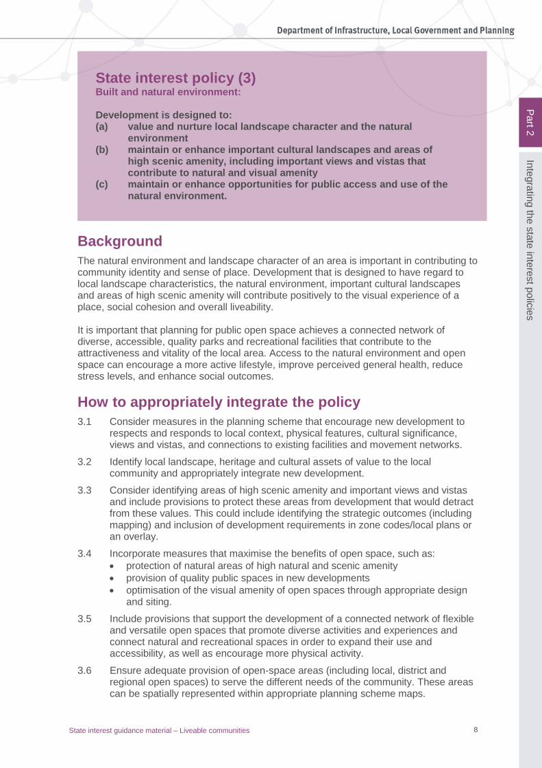
Example code: Fire services in developments accessed by common private title
Application
This code applies where the development:
(1) is for a material change of use or reconfiguring of lot for the purpose of residential, commercial or industrial development where part of the development or any building is more than 90 metres from the nearest located fire hydrant
(2) for attached and detached buildings, not covered in other legislation or planning provisions mandating fire hydrants
(3) the proposed development will include streets and common access ways within a common private title in areas serviced by reticulated water.
Note: The term ‘common private title’ covers areas such as access roads in community title developments or strata title unit access that is private and under group or body-corporate control.
Purpose
The purpose of the SPP code is to ensure that development proposals in an urban area accessed by common private title have appropriate fire hydrant infrastructure and unimpeded access for QFES vehicles (‘Fire Appliance’) for the protection of people, property and the environment from fire and chemical incidents. Table 2: Assessment benchmarks for assessable development
Performance outcomes Acceptable outcomes
PO1 – Installation of hydrant Fire hydrants are installed and located to enable QFES fire-appliance vehicles to access water safely, effectively and efficiently.
AO1.1 Fire hydrant placement and technical requirements for residential streets and common access ways within common private title are in accordance with:
(a) Australian Standard (AS) 2419.1 – 2005 Fire hydrant installations; and/ or
(b) QFES: Fire Hydrant and vehicle access guidelines for residential, commercial and industrial lots.1
AO1.2 Fire hydrant placement and technical requirements for commercial and industrial streets and access ways within streets serving commercial properties, such as factories, warehouses and offices, are in accordance with:
• Australian Standard (AS) 2419.1-2005 Fire hydrant installations; and/or
• QFES: Fire Hydrant and vehicle access guidelines for residential, commercial and industrial lots.
PO2 – Road technical standards Road widths and construction within the development are adequate for fire appliance vehicles to gain access to a safe working area close to buildings and near water supplies whether or not on-street parking spaces are occupied.
No acceptable outcome is nominated.
Note: Roads should be designed and constructed in accordance with Road Planning and Design Manual – 2nd edition – available on the Department of Transport and Main Roads website:
www.tmr.qld.gov.au/business-industry/Technical-standards-publications/Road-planning-and-design-manual-2nd-edition.aspx
1 www.qfes.qld.gov.au/buildingsafety/referral-agency-advice/documents/BFS-FireHydrant.pdf
21 State interest guidance material – Liveable communities
Pa
rt 6
Su
pp
ortin
g in
form
atio
n
Part 6: Supporting information Note: Local governments must consider its local and regional context in the interpretation of this supporting material. It should be considered and applied as locally appropriate, taking into account the demographic, social, cultural, economic and lifestyle needs of the community, development activity and existing built form.
1. Built form and urban design
Planning and design principles
Built form Planning schemes should ensure that development features high-quality urban design that is responsive to local climatic conditions (e.g. subtropical or tropical design) and maximises amenity, street activity and pedestrian access and connectivity. To achieve a high-quality built form through best-practice urban design and place-making:
• ensure every building in a neighbourhood precinct or centre contributes to positive outcomes through appropriate design and functionality
• cluster taller buildings at central nodes and close to transit stations to help promote more efficient use of public transport
• appropriately locate buildings and create places and spaces that preserve views and vistas
• respond to local context in building design, finding innovative ways to complement but not duplicate traditional character; create development that draws on local qualities
• work with the natural topography to minimise cut and fill and create places and spaces that contribute to the visual and environmental amenity
• apply best practice Water Sensitive Urban Design (WSUD) techniques in the design of buildings, places and spaces to sustainably manage surface-water run-off and deliver improved biodiversity, landscape amenity and recreational resources
• design at a human scale with pedestrian-level detail
• create a walkable network of streets and public places that are well connected, safe, attractive and inclusive, and provide a platform for diverse community interactions and commercial exchange
• deliver diverse development forms and density to ensure buildings, streets and spaces offer choice, diversity and mix to meet the diverse demographic, social, cultural, economic and lifestyle needs of the community, including people with disability or mobility impairment, seniors and people requiring assisted living and people with young children
• avoid blank walls and long, single-purpose buildings
• activate street frontages with pedestrian entrances, active land uses (e.g. shops and cafes), windows, public seating, trees and plant boxes and public art
• ensure the main entrance points to buildings are accessible for people of all ages and abilities (including people with disability – refer to National Construction Code (NCC) volume one). Entrances should be well defined and in the main façade of the building, with multiple entrances for multi-unit complexes
• activate upper-floor façades with windows, verandas and balconies
• maximise the development potential of sites in large centres to stimulate vibrant places – this can be supported through limiting setbacks and encouraging flexible and

22 State interest guidance material – Liveable communities
Pa
rt 6
Su
pp
ortin
g in
form
atio
n
appropriate design of buildings, particularly in the core of precincts where higher urban density is encouraged and promoted
• use setbacks sparingly in large centres and avoid them in the core of precincts
• apply passive urban design strategies that take advantage of the local climate and maximise natural elements such as sunlight and breezes to heat, cool and light buildings in order to reduce or eliminate the need for mechanical and electrical systems
• use appropriate building layout design and architectural elements such as hoods, louvres, screens, awnings along with landscape planning characteristics to reduce the impact of temperature extremes and urban heat island effect in buildings, streets and spaces
• identify the climatic region for the local government area and include design elements in urban layout that respond appropriately to the local climatic conditions.
Development intensity Planning schemes should allow for and encourage built form that can support a concentration and mix of employment opportunities. To achieve development and employment intensity:
• allow increased commercial densities in appropriate areas (see table 3: Indicative commercial densities)
• ensure employment diversity by providing a range of employment opportunities and business premises of varying sizes
• seek to avoid an over-dominance of residential components in the early stages of development projects, compromising future employment diversity
• allow the design of ground floors of buildings to convert to commercial uses in response to demand
• intensive commercial uses should be located in the core of centres and achieve densities (measured by commercial plot ratio) above the average for the surrounding precinct
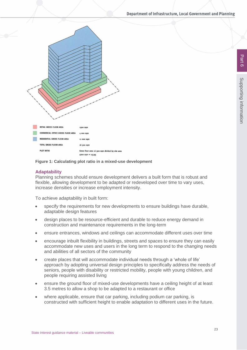
• commercial developments in major employment locations (e.g. activity centres identified in the planning scheme) should aim to achieve plot ratios no less than 3:1 to make the best use of land in these locations (see Figure 1 for advice on how to calculate plot ratio for mixed-use developments). The ability to achieve this will depend on the context, mix of uses and the type of surrounding precinct.
Table 3: Indicative commercial densities
Type Commercial plot ratio
City centre >5:1
Activity centre >3:1
Specialist activity centre >2:1
Urban >3:1
Suburban >2:1
Neighbourhood >1:1
23 State interest guidance material – Liveable communities
Pa
rt 6
Su
pp
ortin
g in
form
atio
n
Figure 1: Calculating plot ratio in a mixed-use development
Adaptability
Planning schemes should ensure development delivers a built form that is robust and flexible, allowing development to be adapted or redeveloped over time to vary uses, increase densities or increase employment intensity. To achieve adaptability in built form:
• specify the requirements for new developments to ensure buildings have durable, adaptable design features
• design places to be resource-efficient and durable to reduce energy demand in construction and maintenance requirements in the long-term
• ensure entrances, windows and ceilings can accommodate different uses over time
• encourage inbuilt flexibility in buildings, streets and spaces to ensure they can easily accommodate new uses and users in the long term to respond to the changing needs and abilities of all sectors of the community
• create places that will accommodate individual needs through a ‘whole of life’ approach by adopting universal design principles to specifically address the needs of seniors, people with disability or restricted mobility, people with young children, and people requiring assisted living
• ensure the ground floor of mixed-use developments have a ceiling height of at least 3.5 metres to allow a shop to be adapted to a restaurant or office
• where applicable, ensure that car parking, including podium car parking, is constructed with sufficient height to enable adaptation to different uses in the future.

24 State interest guidance material – Liveable communities
Pa
rt 6
Su
pp
ortin
g in
form
atio
n
Continuity of activity Planning schemes should encourage continuous activity in major centres or precincts to provide a sense of vitality and safety. To achieve continuity of activity:
• position different land uses to maximise the vitality of the precinct core
• arrange complementary uses for mutual support to reinforce the convenience of walking and cycling
• aim for 18 hours a day of activity in precinct core and mixed-use areas
• locate evening activities along key pedestrian routes and at intersections to maximise passive surveillance and vitality
• ensure buildings on key routes have active frontages to create a safe pedestrian environment.
Planning and design principles for safety
Safety and accessibility Planning schemes should ensure that development promotes a high sense of personal and community safety and equitable access to all public areas. To achieve safety and accessibility:
• incorporate CPTED (crime prevention through environmental design) principles in precinct planning
• include provisions that support the safe use of and accessibility to public spaces for children, seniors, people with disability and the mobility-impaired.
The CPTED principles relate to:
• casual surveillance and sightlines – ensure public spaces are overlooked by active street frontages, windows and balconies and that sightlines extend beyond the immediate environs; avoid blank or ‘dead’ frontages wherever possible
• land-use mix and activity generators – ensure that a mix of land uses fronts public space and key thoroughfares, and generates activity throughout the day and evening
• definition of use and ownership – clearly demarcate boundaries between public and private space to limit trespassing and create distinct public domains
• basic exterior building design – ensure active/permeable building frontages with clearly identified entry and exit points that are visible from public areas; ensure building articulation does not create recesses capable of concealing potential assailants
• lighting – ensure lighting is sufficient to see both the immediate surrounds and approaches to the chosen route; elevated lighting allows for approaching people or vehicles to be seen at a distance
• way-finding – create legible places and spaces that are well signed with clear pathways to important or frequently visited destinations
• choice of routes – predictable pedestrian routes offer more potential for planned criminal activity than permeable street layouts with route choice; similarly, dead-end streets can be potential danger zones
• need to avoid ‘entrapment’ locations – consider the safety of all pedestrian and cycle routes; avoid blank areas, concealed areas or unlit areas that could leave users exposed to danger.

25 State interest guidance material – Liveable communities
Pa
rt 6
Su
pp
ortin
g in
form
atio
n
PA
RT
E
2. Planning for diverse centres and neighbourhoods
Land-use planning
Density Where appropriate to the local area, the planning scheme should incorporate higher-density residential uses in appropriate precincts (centres, areas around transit nodes etc.) to increase vitality and provide convenient access to services and transport. Use the following baseline density guidelines:
• activity centres – 40 to 120 dwellings per hectare (net) or greater
• suburban and neighbourhood locations – 30 to 80 dwellings per hectare (net) or greater.
To achieve appropriate density promoting vitality in a medium-density to high-density urban context:
• prioritise higher-density activities within centres and around transit nodes, appropriate to the type of precinct or centre and its role, and match density to accessibility – the higher the accessibility, the higher the density
• intensify the core of major centres or precincts – consolidate density in the core of the precinct/centre and taper off towards the outer areas of the precinct/centre
• optimise the density potential of available developable land and balance the non-usable and open-space components (e.g. use minimal setbacks, minimise reliance on surface car parking)
• encourage site amalgamation in higher-density areas, where possible, to enable development of appropriate scale and intensity to occur (e.g. by using development allowances or incentives for larger properties)
• respond to local context and character – high-density doesn’t necessarily mean high rise
• ensure good design reflects the local climate and respects local context and character through design codes
• ensure public buildings establish a quality benchmark
• consider using an independent design review panel to ensure high-quality design. Mix of land uses Planning schemes should provide for and integrate a mix of uses to create a greater variety of services catering for the diverse needs of a vibrant community. Planning schemes should ensure the timely and convenient access to services and facilities required to support people’s daily needs, including an appropriate mix of commercial and retail services, jobs, community infrastructure and open space relevant to the context of the surrounding area. To achieve an appropriate mix of uses to promote a vibrant community:
• co-locate a range of residential, commercial, retail and other uses
• allocate the mix of residential, commercial and retail uses according to the precinct type
• emphasise uses that complement the role of a precinct or centre in the broader network or particular function
• include land uses that meet the daily needs of the local community, including people with disability

26 State interest guidance material – Liveable communities
Pa
rt 6
Su
pp
ortin
g in
form
atio
n
• increase the use of centre zones and mixed-use zones
• ensure new residential zones are close to other zones that will provide employment and recreation opportunities
• residential zones allow appropriate non-residential uses that meet the daily needs of the local community
• integrate education, healthcare and social services within high-density, mixed-use environments
• encourage site and context analyses for new developments to reveal particular uses lacking in a precinct (e.g. affordable housing in an urban precinct or childcare in a neighbourhood precinct) and perform similar analyses when developing neighbourhood plans
• ensure uses in the core of major centres or precincts offer active street frontages and are not overly car reliant.
Diversity
Community diversity adds to vitality. Vibrant places attract people, are great places to live and are economically successful. Cultural diversity is a recognised factor contributing to creative and innovative economies where people mix social, business and cultural activities. Ready access to interesting, well-designed and diverse open spaces supporting a range of different activities adds to the overall lifestyle appeal, bringing with it significant health benefits and increased social contact and sense of community. This will increase the appeal of the precinct and help it retain this appeal over time. Nine key factors have been identified as most influential in promoting community diversity:
• urban form and land use
• housing choice and diversity
• access to diverse jobs
• retail diversity
• social infrastructure
• access and movement
• quality open space, recreation and the public domain
• community engagement and collaboration
• community and cultural development.
Supporting social diversity and inclusion
Planning schemes should ensure that new development creates an environment that supports social inclusion, equity and diversity for all people, including different ages, mobility or impairment, cultural, employment and income groups. To encourage social diversity and inclusion:
• provide for a range of housing types, tenures and sizes to cater for different ages, household sizes and socio-economic groups and people requiring assisted living
• set goals for the provision of non-market affordable housing and consider mechanisms to incorporate affordable housing into private development
• provide community services and facilities that respond to community needs and comply with precinct design and density principles

27 State interest guidance material – Liveable communities
Pa
rt 6
Su
pp
ortin
g in
form
atio
n
PA
RT
E
• understand the demographic composition of communities, including, existing demographic analysis, forecast population growth and consultation with human services and emergency agencies to plan for future community services and facilities that are inclusive, flexible and equitable for all members of the community
• locate facilities for convenient access to pedestrian and cycle networks and public transport stations, and to help contribute to a sense of community (e.g. a community focal point or hub)
• provide a network of flexible and versatile spaces offering a diversity of activities and experiences, including social activities (e.g. meeting, talking, markets, community events), recreation activities (e.g. pleasure, exercise, play, sport), connection with nature (e.g. stimulation of the senses), as well as pedestrian and cycle paths. A network of spaces will expand their utility and accessibility and encourage more physical activity and promote health-related benefits.
Access to diverse jobs
Employment diversity enables people to live and work in the same neighbourhood, while also attracting a diversity of workers into the area. Creating precincts and centres that provide for diverse land uses and jobs expands local employment opportunities and contributes to the mix of people, which adds to the overall vitality and identity of a community. Jobs, businesses and cultural diversity are interdependent, helping to foster a more resilient and creative local economy. However, the establishment of centres or precincts in low-rent areas can also lead to the displacement of existing small businesses that are reliant on low rents, reducing employment diversity and opportunities for small and starter businesses. Specific strategies are needed to reduce this effect.
Supporting community diversity through employment
Diversity in jobs depends on the range of businesses and organisations operating in and around the precincts and centres within a community. There are a number of ways that job diversity can be stimulated:
• include strategies in the strategic objectives of the planning scheme to strengthen and diversify the local economy and employment opportunities
• encourage local skill development through providing land for education and training, preferably in locations accessible to on-the-job training
• ensure that land-use measures support the creation of diversity by enabling a range of land uses and building footprint sizes to support operations of varying scales
• allow housing to be designed to support the operation of home-based businesses, incorporating features such as flexibility in the use of rooms, internet infrastructure and the location of office space near the front door and away from living spaces.
Neighbourhood design
All sites need to be designed in a way that recognises the existing neighbourhood pattern, if any, and the creation of new neighbourhoods. This consideration should be initially assessed as part of the preparation of the brief and incorporated into the vision for the project. There are no absolute rules for the size, shape and design of a neighbourhood. However, it is at the local level where the sense of ‘neighbourliness’ has the greatest potential to emerge. The neighbourhood is often defined in terms of how far residents are happy to stroll or cycle to a desired point, whether it is to visit friends, buy a loaf of bread, or go to the local park. It takes some time for a neighbourhood community to emerge, and respect
28 State interest guidance material – Liveable communities
Pa
rt 6
Su
pp
ortin
g in
form
atio
n
should be given to the quality of life in existing neighbourhoods where new neighbourhoods are proposed. Where possible, all new development should be planned, designed and delivered to facilitate the creation of new neighbourhoods and contribute to the enhancement of existing neighbourhoods.
Respecting local conditions in the neighbourhood plan
The neighbourhood layout and design should respect and respond appropriately to local conditions, including:
• the local market and need for housing and businesses
• physical features such as topography, natural drainage systems and vegetation
• places of cultural heritage significance
• opportunities for views and vistas and other elements that will clearly identify and form a commercial perspective, i.e. ‘brand’ the neighbourhood
• providing connections to existing facilities, services and movement networks in the surrounding area.
Making the neighbourhood work as a community
To help achieve a healthy community, a new neighbourhood will typically be created with:
• defined entries and legible neighbourhood boundaries to foster a sense of identity
• a highly permeable, legible street pattern
• a variety of multi-use parks and green spaces
• a safe, attractive, connected and efficient pedestrian and cycle network
• a distribution of land uses, layout of streets and building densities that support public and active transport use
• a mix of lot sizes providing wide choice in affordable, accessible and adaptable housing
• lots of a size to allow small-scale, compatible land uses such as childcare, aged care, retirement living, local shops and home-based businesses.
Model centres design for larger urban areas
The scale and nature of centres vary depending on each centre’s particular attributes and the size and characteristics of its catchment. Individual centres form part of a network of centres. For the purposes of this guideline, the hierarchy of centres is considered to comprise the following types: Major centres Major centres (also town centres or sub-regional centres) are located around a significant transit node, and at the centre of the transport networks serving the community. These are relatively large centres that typically service a catchment population of 50,000 to 150,000 people, and provide a large number and range of employment opportunities. They contain the greatest mix of land uses and the highest development densities and are the principal focus of the community. Major centres usually have a central, highly accessible core, which contains the highest density of development and accommodates land uses such as major and specialist retail, professional and other specialist services, and civic, education, health and cultural facilities that benefit from a highly accessible location.

29 State interest guidance material – Liveable communities
Pa
rt 6
Su
pp
ortin
g in
form
atio
n
The major centre frame has a lower intensity of development and accommodates uses that support the activities in the major centre core or serve a similarly large catchment but do not require the same high level of accessibility. District centres District centres (or secondary centres) also provide a wide range of services and facilities but are significantly smaller in scale and lower in development intensity than major centres, serving a catchment population of 40,000 to 80,000. District centres provide a focal point for inter-suburban transport networks and for surrounding medium-density neighbourhoods. District centres provide health, education and community facilities, and a range of shops, including full-line supermarkets and specialist stores to cater for weekly shopping needs. Neighbourhood centres Neighbourhood centres provide a limited range of services, including convenience retail, to a cluster of local neighbourhoods. Neighbourhood centres attract frequent trips from within their catchments. They have good local accessibility, particularly by active transport, and act as a focal point and meeting place for the local community. A sense of community and the social life of the neighbourhood make the community healthy, safe, socially sustainable, and strengthen the local economy. Neighbourhood centres generally serve a catchment population of 10,000 to 15,000. In addition to those centres, a community can also contain small local groups of shops and offices. However, these are small-scale, stand-alone developments rather than centres and are not addressed in the following guidance material. Centre layout The layout of each centre needs to respond to its particular setting and characteristics, including such matters as existing natural features, role in the centre’s network and relationship to transport networks. However, there are certain basic principles that underpin the structure of successful centres, and should provide the initial starting point for any centre design activities. Detailed guidance regarding centre layout and design, including built form, public realm, street networks and parking, is provided in the following tables.
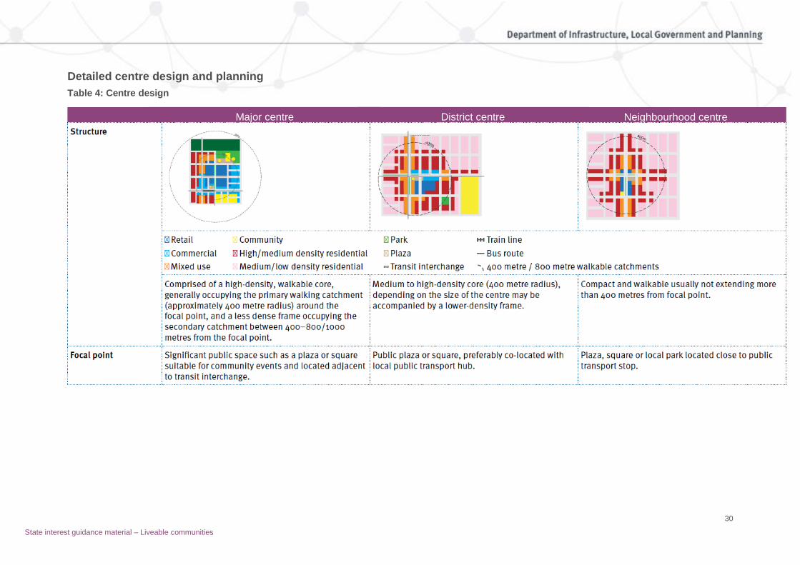
30
Major centre District centre Neighbourhood centre
Detailed centre design and planning
Table 4: Centre design
State interest guidance material – Liveable communities

31
Land-use mix Core – wide range of land uses including retail, business, residential, education and community/civic facilities with main street precinct focus. Substantial retail with high degree of vertical separation with active uses on ground floors and commercial/residential uses above.
Wide range of land uses focused on a main street retail precinct with at least one full-time supermarket. Some vertical mixing of land uses with residential/business uses above active ground-floor uses, particularly in the main streets. Lower-intensity development towards edge of centre or in centre frame.
Predominantly retail and community uses at ground level, with residential/office activities above.
Retail to include a supermarket that may not be full-line, depending on centre catchment.
Community facilities Locate community facilities require high levels of accessibility within or adjoining centres. Refer to Supporting information for more guidance on locating community facilities.
Height and density Tallest buildings and highest development density in its catchment area. Height and density should be highest in the core and generally decrease with distance from the core.
Significantly lower building height and development intensity than the major centre. Density should be highest near the focal point and generally transition to match surrounding heights and densities.
Commensurate with surrounding development. Usually no more than 3 storeys in suburban neighbourhoods.
Transition Incorporate residential into mixed-use developments near residential neighbourhoods to provide a transition between residential and non-residential uses.
Public transport Focused on a major transport interchange based around a line haul transit station (usually rail or busway).
Local public transport hub – can be rail/bus or connection of inter-suburban bus routes.
One or more local bus routes linking catchment neighbourhoods to centre.
Relationship to transit node
Integrate transit station entries/forecourts into the centres public realm/open space network. Ensure areas around transit station entries are developed for retail and other active uses that stay open for extended periods to provide activity and improve personal safety.
Locate bus stops close to focal point and retail core.
Development staging Higher-density buildings may not be visible until the community reaches certain development thresholds. Key, highly accessible lots should be retained for longer-term development when these thresholds are achieved. Staging of development to replace initial lower-intensity development with more intense development over the longer term is also acceptable.
Interim uses Depending on the specific context, a range of interim uses may be acceptable within a centre. The key tests to determine acceptability are whether the interim use would be compatible with existing and proposed centre activities and whether the interim use would be likely to prejudice or delay the ultimate development of the site and adjoining areas. Interim uses should be low intensity in nature and characterised by a low investment in buildings and infrastructure relative to the value of the site. Examples of uses that could pass the test include: bulk landscape supplies, garden centre, market, outdoor sales, wholesale nursery, indoor or outdoor sports and recreation.
CPTED Ensure that the centre layout achieved the CPTED principles for the design of centres.

32 State interest guidance material – Liveable communities
A fine-grained street network encourages pedestrian movements and street activity,
contributing to the vitality of the centre.
Table 5: Streets and lots within a centre
Major centre District centre Neighbourhood centre
Street network (internal)
Highly connected, legible and permeable grid. Network promotes safe movements and provides direct pedestrian and cyclist access to the centre’s focal point/transit opportunities.
All streets should accommodate multiple transport modes to encourage activity and personal safety.
Streets should accommodate on-street parking and vehicle movements without compromising walking and cycling safety and amenity.
The street network should provide sufficient capacity for service vehicles, taxis and public transport stops and layovers as required.
Focus internal street design around achieving a safe and attractive main street as the heart of the retail, entertainment and civic/cultural uses.
Development on main streets with active frontages are provided with access from rear lane or other access streets for service vehicles and to parking areas to reduce potential conflicts with pedestrians and cyclists.
Internal street types and design
Grid network of main streets, connector streets and access streets and lanes.
Main street located parallel to and adjacent to connector street where necessary to maintain pedestrian amenity due to traffic volumes. Rear lane to service centre.
Streets should be designed to accommodate all activities that take place in the street (such as outdoor dining, landscaping, bus stops, cycle lanes and on-street parking), not just the roadway or vehicle movements.
Ensure streets provide access for emergency vehicles.
Preferred block size Parallel streets not more than 100 m, and total block perimeter no greater than 600 m.
Maximum block size
200 m x 120 m 180 m x 80 m 150 m x 70 m
Pedestrian links Where block lengths exceed 120 m, a mid-block pedestrian and cycle connection with a minimum width of 6 m, constant public access incorporating CPTED principles should be provided.
Active transport links
Provide direct links from the centre street network to the main pedestrian and cycle network.
Weather protection All streets (except lanes) are provided with awnings where buildings are built to the street frontages and/or street trees to provide weather protection and visual amenity.
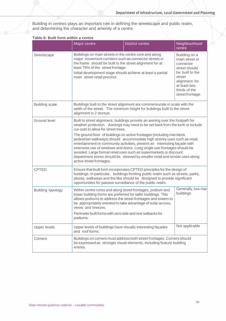
33 State interest guidance material – Liveable communities
Building in centres plays an important role in defining the streetscape and public realm, and determining the character and amenity of a centre. Table 6: Built form within a centre
Major centre District centre Neighbourhood centre
Streetscape Buildings on main streets in the centre core and along major movement corridors such as connector streets in the frame should be built to the street alignment for at least 75% of the street frontage.
Initial development stage should achieve at least a partial main street retail precinct.
Building on a main street or connector street should be built to the street alignment for at least two-thirds of the street frontage.
Building scale Buildings built to the street alignment are commensurate in scale with the width of the street. The minimum height for buildings built to the street alignment is 2 storeys.
Ground level Built to street alignment, buildings provide an awning over the footpath for weather protection. Awnings may need to be set back from the kerb or include cut-outs to allow for street trees.
The ground floor of buildings on active frontages (including mid-block pedestrian walkways) should accommodate high activity uses such as retail, entertainment or community activities, present an interesting façade with extensive use of windows and doors. Long single use frontages should be avoided. Large format retail uses such as supermarkets or discount department stores should be sleeved by smaller retail and similar uses along active street frontages.
CPTED Ensure that built form incorporates CPTED principles for the design of buildings. In particular, buildings fronting public realm such as streets, parks, plazas, walkways and the like should be designed to provide significant opportunities for passive surveillance of the public realm.
Building typology Within centre cores and along street frontages, podium and tower building forms are preferred for taller buildings. This allows podiums to address the street frontages and towers to be appropriately oriented to take advantage of solar access, views and breezes.
Perimeter built forms with zero side and rear setbacks for podiums.
Generally, low-rise buildings
Upper levels Upper levels of buildings have visually interesting façades and roof forms.
Not applicable
Corners Buildings on corners must address both street frontages. Corners should be expressed as stronger visual elements, including feature building entries.
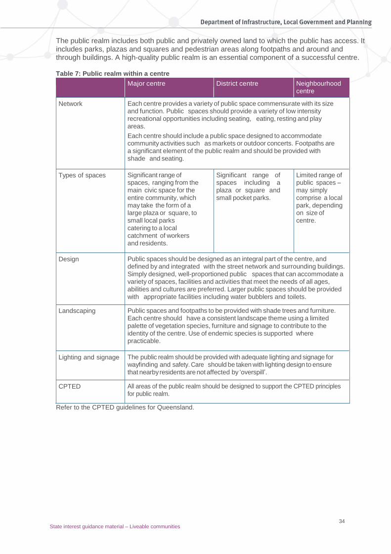
34 State interest guidance material – Liveable communities
The public realm includes both public and privately owned land to which the public has access. It includes parks, plazas and squares and pedestrian areas along footpaths and around and through buildings. A high-quality public realm is an essential component of a successful centre. Table 7: Public realm within a centre
Major centre District centre Neighbourhood centre
Network Each centre provides a variety of public space commensurate with its size and function. Public spaces should provide a variety of low intensity recreational opportunities including seating, eating, resting and play areas.
Each centre should include a public space designed to accommodate community activities such as markets or outdoor concerts. Footpaths are a significant element of the public realm and should be provided with shade and seating.
Types of spaces Significant range of spaces, ranging from the main civic space for the entire community, which may take the form of a large plaza or square, to small local parks catering to a local catchment of workers and residents.
Significant range of spaces including a plaza or square and small pocket parks.
Limited range of public spaces – may simply comprise a local park, depending on size of centre.
Design Public spaces should be designed as an integral part of the centre, and defined by and integrated with the street network and surrounding buildings. Simply designed, well-proportioned public spaces that can accommodate a variety of spaces, facilities and activities that meet the needs of all ages, abilities and cultures are preferred. Larger public spaces should be provided with appropriate facilities including water bubblers and toilets.
Landscaping Public spaces and footpaths to be provided with shade trees and furniture. Each centre should have a consistent landscape theme using a limited palette of vegetation species, furniture and signage to contribute to the identity of the centre. Use of endemic species is supported where practicable.
Lighting and signage The public realm should be provided with adequate lighting and signage for wayfinding and safety. Care should be taken with lighting design to ensure that nearby residents are not affected by ‘overspill’.
CPTED All areas of the public realm should be designed to support the CPTED principles for public realm.
Refer to the CPTED guidelines for Queensland.
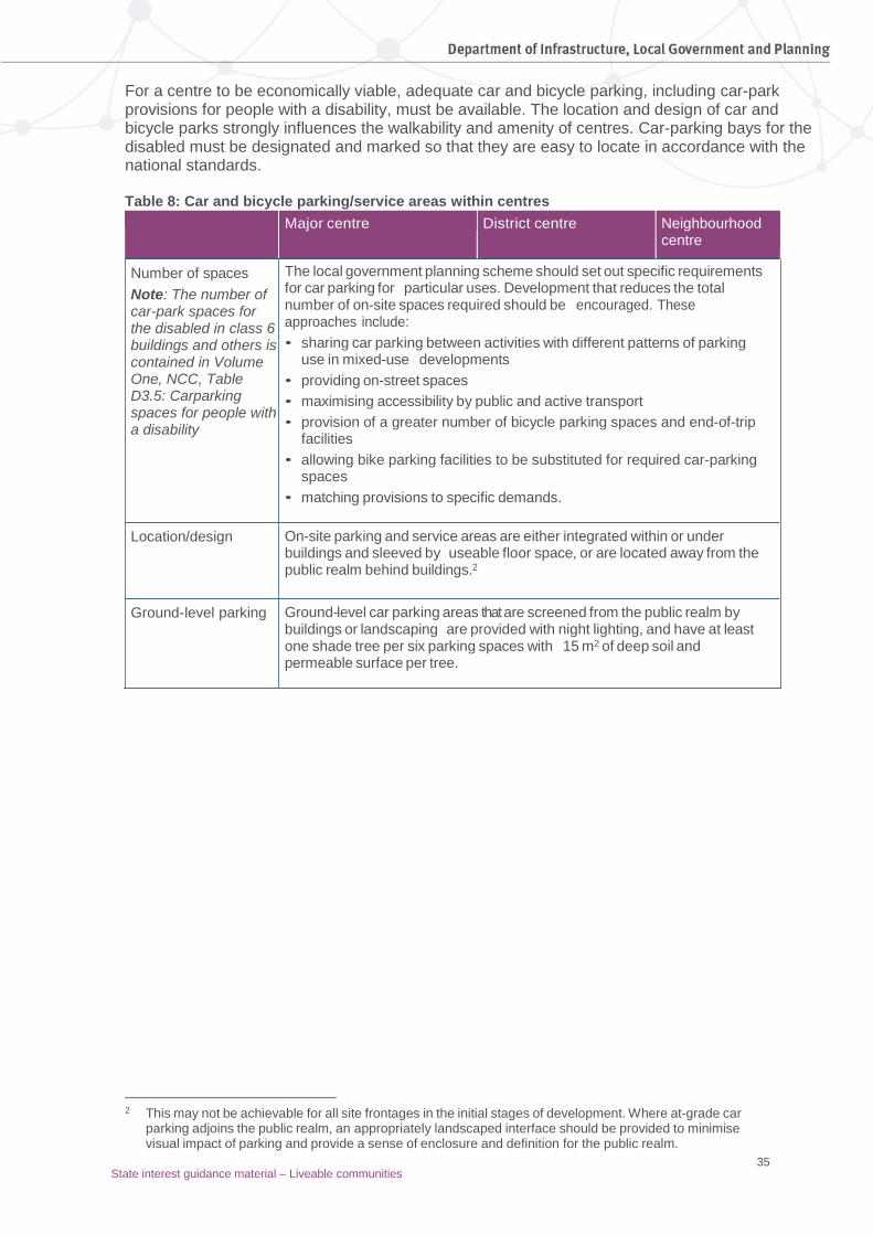
35 State interest guidance material – Liveable communities
For a centre to be economically viable, adequate car and bicycle parking, including car-park provisions for people with a disability, must be available. The location and design of car and bicycle parks strongly influences the walkability and amenity of centres. Car-parking bays for the disabled must be designated and marked so that they are easy to locate in accordance with the national standards. Table 8: Car and bicycle parking/service areas within centres
Major centre District centre Neighbourhood centre
Number of spaces
Note: The number of car-park spaces for the disabled in class 6 buildings and others is contained in Volume One, NCC, Table D3.5: Carparking spaces for people with a disability
The local government planning scheme should set out specific requirements for car parking for particular uses. Development that reduces the total number of on-site spaces required should be encouraged. These approaches include:
• sharing car parking between activities with different patterns of parking use in mixed-use developments
• providing on-street spaces
• maximising accessibility by public and active transport
• provision of a greater number of bicycle parking spaces and end-of-trip facilities
• allowing bike parking facilities to be substituted for required car-parking spaces
• matching provisions to specific demands.
Location/design On-site parking and service areas are either integrated within or under buildings and sleeved by useable floor space, or are located away from the public realm behind buildings.2
Ground-level parking Ground-level car parking areas that are screened from the public realm by buildings or landscaping are provided with night lighting, and have at least one shade tree per six parking spaces with 15 m2 of deep soil and permeable surface per tree.
2 This may not be achievable for all site frontages in the initial stages of development. Where at-grade car
parking adjoins the public realm, an appropriately landscaped interface should be provided to minimise visual impact of parking and provide a sense of enclosure and definition for the public realm.

36
Pa
rt F
Su
pp
ortin
g in
form
atio
n
State interest guidance material – Liveable communities
3. Public open space and quality public realm
The public domain includes public open space, public plazas and other pedestrian areas, including publicly accessible but privately owned civic spaces (e.g. shopping malls and building setbacks). The quality of the public domain is influenced by its availability, accessibility, diversity, utility and meaning to users and the contact and experience it offers with nature. Vitality in the public domain is critical to creating successful communities (particularly in neighbourhoods, precincts and centres) and attracting people to live, work and visit. Vital places also confer a sense of safety and are socially inclusive. The public domain connects people with the place, each other and nature. It must offer a series of diverse spaces that accommodate a range of different uses, users and needs, and allows for different activities at different times of the day and in different seasons. In planning higher-density neighbourhoods, the public domain takes on a more significant role as the outdoor living room of the neighbourhood than in a suburban setting. Access to basic environmental amenities is important to the wellbeing of both residents and workers, providing places for recreation and sport, social interaction, physical activity, getting around and leisure. Safe and convenient access to parks and other green spaces also has major health benefits, by encouraging greater physical activity and reducing stress levels. Privatised space (e.g. outdoor cafes, private malls and plazas) is associated with social exclusion. For example, the dominance of outdoor cafes can exclude those without the financial means to participate. Care is needed to ensure that the management of other private spaces does not make any social groups (e.g. elderly people, teenagers or Indigenous people) feel unwelcome – nor should these spaces replace the traditional role of publicly owned space.
Planning for public open space
The objective for public open space is to achieve a network of diverse, inclusive, accessible, quality parks and recreational facilities that are sustainable, contribute to the attractiveness and vitality of communities, and enhance people’s health and wellbeing by meeting their needs for outdoor recreation in urban settings now and into the future. The primary purpose of public open space is that it is intentionally set aside to provide for a range of sporting, recreation, leisure, cultural and educational activities. Examples of ‘public open space’ are:
• playing fields for formal outdoor sports
• recreation parks for informal, unstructured play and playgrounds
• amenity parks for rest, contemplation, enjoyment of nature and respite from the urban environment
• parks and civic spaces for community gatherings and events. There exists a variety of other open spaces that, while perceived and used as public open space, do not meet the primary purpose of public open space. These ‘other spaces’ include riparian corridors, areas set aside to protect environmental and heritage values, beach and coastal dune areas, drainage reserves, and spaces within education facilities.

37
Pa
rt F
Su
pp
ortin
g in
form
atio
n
State interest guidance material – Liveable communities
As public open space is not the primary purpose of these other spaces, they are generally not included within the definition of ‘public open space’ or count towards the overall quantum of public open space. However, the importance of these other spaces as sites for passive recreation, pedestrian and cycle linkages and amenity should be considered in the local planning context. The following principles should be used to guide the public open space planning and design process within local government planning schemes.
Diverse and inclusive spaces
The public open space network should provide a diverse range of settings and opportunities that cater for the varied recreational needs of residents and visitors of all ages and abilities, including people with disability. These settings may include both active spaces, which are primarily designed for users to participate in physical and social activity, and passive spaces, which are primarily designed for their natural or created amenity or views. All but the smallest parks should be designed to provide a variety of settings ranging from places for group activities and events to active play areas and places for quiet contemplation. Public open spaces that also focus on the interaction between different activity areas are more interesting places that can also be more convenient to users. The interactions between different park users and activities create animation and interest through activation synergies, rather than a series of isolated events. Diversity and inclusion should be addressed at all levels of planning and design. To achieve diverse and inclusive spaces:
• provide a range of public open-space settings at the broad networks level from natural and semi-natural places to highly modified areas for organised sports.
• locate and design open space to highlight significant local features such as waterways, hills and ridgelines.
• plan and design open spaces to provide various settings and opportunities for formal sports and active and passive recreational opportunities.
• ensure that public open space that is primarily for sports activities should also include informal recreational opportunities to cater for diverse user groups.
• designate high-activity uses in convenient locations close to park access points.
Encourage activation synergies including:
• locating shelters to overlook a playground or other active recreation space
• designing pathways to travel between activity nodes and lookouts to destination
• situating a large open area for active recreation next to areas of natural bushland and associated trails.
For recreation parks it is important to achieve a balance between active and passive recreation spaces. Table 9 shows the minimum level of active recreation spaces that should be provided for each type of recreation park. Sport parks should also include various informal and passive recreation opportunities to complement the sports areas and facilities.
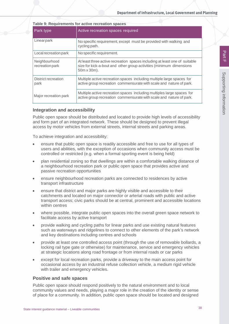
38
Pa
rt F
Su
pp
ortin
g in
form
atio
n
State interest guidance material – Liveable communities
Table 9: Requirements for active recreation spaces
Park type Active recreation spaces required
Linear park No specific requirement, except must be provided with walking and cycling path.
Local recreation park No specific requirement.
Neighbourhood recreation park
At least three active recreation spaces including at least one of suitable size for kick-a-bout and other group activities (minimum dimensions 50m x 30m).
District recreation park
Major recreation park
Multiple active recreation spaces including multiple large spaces for active group recreation commensurate with scale and nature of park.
Multiple active recreation spaces including multiples large spaces for active group recreation commensurate with scale and nature of park.
Integration and accessibility
Public open space should be distributed and located to provide high levels of accessibility and form part of an integrated network. These should be designed to prevent illegal access by motor vehicles from external streets, internal streets and parking areas. To achieve integration and accessibility:
• ensure that public open space is readily accessible and free to use for all types of users and abilities, with the exception of occasions when community access must be controlled or restricted (e.g. when a formal sporting event is being held)
• plan residential zoning so that dwellings are within a comfortable walking distance of a neighbourhood recreation park or public open space that provides active and passive recreation opportunities
• ensure neighbourhood recreation parks are connected to residences by active transport infrastructure
• ensure that district and major parks are highly visible and accessible to their catchments and located on major connector or arterial roads with public and active transport access; civic parks should be at central, prominent and accessible locations within centres
• where possible, integrate public open spaces into the overall green space network to facilitate access by active transport
• provide walking and cycling paths for linear parks and use existing natural features such as waterways and ridgelines to connect to other elements of the park’s network and key destinations including centres and schools
• provide at least one controlled access point (through the use of removable bollards, a locking rail type gate or otherwise) for maintenance, service and emergency vehicles at strategic locations along road frontage or from internal roads or car parks
• except for local recreation parks, provide a driveway to the main access point for occasional access by an industrial refuse collection vehicle, a medium rigid vehicle with trailer and emergency vehicles.
Positive and safe spaces
Public open space should respond positively to the natural environment and to local community values and needs, playing a major role in the creation of the identity or sense of place for a community. In addition, public open space should be located and designed

39
Pa
rt F
Su
pp
ortin
g in
form
atio
n
State interest guidance material – Liveable communities
to provide a safe environment, enhance physical and mental health by encouraging physical and social activities, and provide opportunities for respite from the surrounding built environment. To achieve positive and safe spaces:
• design spaces to take advantage of natural features, provide opportunities for social interaction and community events, be lively, attractive and interesting places about which the community feels a sense of pride and ownership
• incorporate the principles of CPTED, including clear sightlines from nearby buildings and roads and appropriate lighting
• encourage a variety of recreational opportunities and facilities that attract a range of users to ensure high levels of activity for extended periods
• identify and appropriately treat potentially unsafe areas such as those close to as busy roads or unsecured water bodies
• design spaces that are accessible and functional for all members of the community including seniors, families with young children, and people with disability or mobility impairment
• incorporate features that support broad community use including provision of shade, shelter, diverse and appropriate seating, lighting, clear and legible signage, and accessible public toilets.
Cost-effectiveness of public open spaces
Public open space should be planned and designed to balance capital costs with ongoing maintenance and operational costs. To achieve cost-effectiveness:
• design spaces to take advantage of natural features, provide opportunities for social interaction and community events, be lively, attractive and interesting places about which the community feels a sense of pride and ownership
• encourage the multiple use of public open space and shared use of community facilities, where the proposed uses are safe and compatible, as a means of reducing initial development costs (including cost of land acquisition) and the ongoing costs of the parks network to the community
• integrate flood and stormwater management elements, utility corridors and active transport links into parkland
• co-locate recreation, sporting and community facilities such as state and non-state school ovals and use of natural and semi-natural areas for compatible recreation purposes
• consider the specification of open-space embellishments that are long-lasting, require limited maintenance and incorporate sustainability principles
• group facilities that require high maintenance together in accessible locations to reduce overall maintenance effort
• in all cases, the inclusion of multiple-use elements should not diminish the functionality of the park or its recreational use values.
Flexible and fit-for-purpose
Public open space should be fit for purpose and capable of adapting to cater for changing recreational demands.

40
Pa
rt F
Su
pp
ortin
g in
form
atio
n
State interest guidance material – Liveable communities
PA
RT
E
To achieve flexible and fit-for-purpose open spaces:
• Plan for the appropriate location, size, shape, physical characteristics and facilities to accommodate the intended range of activities and compatibility with adjoining land uses.
• Include, as a significant proportion of the park’s network, larger and more regularly shaped parks that are inherently more flexible.
• Limit the proportion of land with steep slopes or other significant constraints in the park’s network, while encouraging some degree of varied topography.
• Design public open space to respond to the local climate including the provision of shade, locally endemic species, passive cooling and the availability of water in hot climates.
• Ensure that public open space is comfortable and attractive for the intended activities (e.g. areas with high noise levels may be acceptable for short duration sports activities but would not be appropriate for walking trails, picnicking and other quieter activities).
Planning for the public realm
Planning schemes should provide for a high-quality public realm that meets the needs of the surrounding community, including open space, pedestrian areas and transit access. Planning schemes should encourage public realm design that promotes social interaction and inclusion, physical activity and the development of a sense of place and identity. For public realm at a local scale and/or in built form:
• ensure public realm improvement is an integral part of private sector developments
• encourage a reduction in the width of road carriageways and enable wide footpaths, street trees and landscaping space for outdoor dining or street furniture
• introduce traffic-calming measures, where appropriate, to disperse motor vehicles and reduce speeds
• in high-density urban areas consider the use of green walls and rooftop gardens where site cover constrains tree planting
• allow for large shade trees in public and private spaces. Preference the planting of native trees extensively throughout the built environment and preserve existing trees during new construction, particularly in greenfield areas.
For land-use planning and neighbourhood design of public realm:
• encourage the design of places for people that reflects the needs of each neighbourhood – when people have less access to private open space, the quality of the streets and public realm become more important
• provide a range of open spaces and recreational opportunities arranged to optimise efficient use of space in each neighbourhood or precinct
• connect pocket parks with linear parks, landscaped streets and stormwater easements to create a network of public spaces
• for high-density residential neighbourhoods, ensure new multi-unit developments provide at least 20 to 30 square metres combined of private and communal open space per dwelling
• require shaded streets and median strips as part of new developments
• provide a continuous canopy of trees or awnings over footpaths along key pedestrian routes

41
Pa
rt F
Su
pp
ortin
g in
form
atio
n
State interest guidance material – Liveable communities
• use public art and streetscape features to promote a sense of place and local identity.
For high-quality transport infrastructure in public realm:
• design streets and public spaces around transit nodes, such as train or bus stations, at a human scale and with the pedestrian uppermost in mind
• ensure transit stations are highly accessible for all persons, including people with disability, from surrounding areas and visible from the local road network
• bear in mind when planning station access arrangements that pedestrians tend to take the shortest route to their destination and will only be deterred by major obstacles, particularly if the destination is in their sight
• ensure routes to transit stations through joint development are direct and convenient for pedestrians and cyclists, and not obstructed by internal roads, slip lanes, vehicular cross-overs or car parking
• ensure routes to transit stations through joint development are publicly accessible 24/7 and provide clear and legible access through the development to the station and to amenities such as bicycle storage
• include code provisions for uses around transit stations to optimise activity and passive surveillance of through routes to the station
• create safe connections across transit corridors in situations where the transit infrastructure acts as a barrier to pedestrian and cycle movement
• consider on-street bus lanes and/or light-rail corridors (where travel demand and distances warrant these modes) as these are more permeable, allowing interaction and movement across transit corridors
• ensure station entrances are easy to identify and not secondary to other premises or fully embedded within a building – the station should have a presence in the public domain and ideally be supported by public space such as a forecourt.
4. Transport integration and accessibility High-quality transport infrastructure, networks and connections for a liveable community
Integration and accessibility To address transport integration and accessibility, planning schemes should:
• incorporate direct, attractive and safe pedestrian links to transit stations and between neighbourhoods and employment centres, transit interchanges and community facilities
• develop a coherent and legible streetscape that is oriented to pedestrian and/or cyclist movement and offers safety, connectivity, legibility and permeability. The network should be supported by clear directional signage
• emphasise public safety in the design of all transit modes and routes so that all groups feel confident in using the mode of transport of their choice
• provide equitable access for people with disability or restricted mobility along continuous paths of travel in the public domain and to all parts of premises to which the public is entitled access.

42
Pa
rt F
Su
pp
ortin
g in
form
atio
n
State interest guidance material – Liveable communities
Transport efficiency Planning schemes should facilitate a high level of intermodal connection. To achieve transport efficiency:
• where possible, design precincts around transit stations, with the station located at the core of the precinct
• ensure safe, attractive and easy interchange between different transport modes
• provide bicycle storage and lockers at transit nodes
• locate ticket offices and vending machines conveniently for all modes
• install real-time service information
• ensure passive surveillance of all waiting areas and links between modes
• provide good pedestrian and/or cycle access as a higher priority than vehicle access. Integration
Local government planning schemes should ensure that design seamlessly integrates transit nodes and the community. To maximise transport integration:
• when undertaking neighbourhood, precinct or centre planning, identify transport movements and prepare an integrated transport plan
• manage place vs. node conflicts by putting the needs of the local community ahead of car-based commuters, visitors and through-traffic
• plan and manage access for commuters
• ensure there are clear transitions from higher-density centres or precincts to residential neighbourhoods
• provide high-quality intermodal connections with links between trains, buses, taxis and other forms of transport
• allow for increasing levels of pedestrian movement and use of public transport as fuel costs rise. Provide sufficient public space at transit stops, activated with civic, retail and commercial functions for growth
• protect and enhance pedestrian and cycle connectivity in the construction of new transit infrastructure
• achieve an improved balance between vehicular, cyclist and pedestrian use of the public domain by reducing car dominance and increasing access for pedestrians and cyclists.
Mode share Local government planning schemes should maximise mode share for walking, cycling and public transport by providing high levels of accessibility and public amenity within precincts to stations and surrounding areas for cyclists and pedestrians, with priority for pedestrians. To maximise mode share:
• where possible in new developments or greenfield development, create a permeable and interconnected street network such as a traditional grid pattern or modified grid
• where possible in new developments or greenfield development, use street lengths between 80 and 200 metres and mid-block connections to improve pedestrian movement

43
Pa
rt F
Su
pp
ortin
g in
form
atio
n
State interest guidance material – Liveable communities
• make direct and legible connections between key destinations.
Street design The function of streets is an extremely important part of planning, as streets provide the main linkages within and between neighbourhoods, centres, industrial and other areas of a community. A brief overview of the functions and uses of streets will be given below. Complete streets, produced by the Institute of Public Works Engineering Australia 2010, http://engicom.com.au/ outlines the importance and functions of street design with urban, residential and industrial development, identifying the following principal functions that a street must include:
• provision of routes for vehicles and public transport
• accommodation of utility services and drainage systems
• provision of pedestrian and cyclist movement
• street tree planting and water-sensitive features
• space for parking. More information may also be found in the Next generation planning handbook, South East Queensland Council of Mayors 2010 www.statedevelopment.qld.gov.au/resources/guideline/ngp-handbook.pdf. The movement network should be designed to encourage walking and cycling by:
• ensuring a highly interconnected and permeable street network
• establishing good linkages to surrounding development and features
• providing a well-located, legible and convenient to use pathway network.
Creating a highly legible and well-connected street pattern The development of new areas should provide a high level of connectivity within and to surrounding areas. Connected neighbourhoods should continue existing desire lines and provide access for existing and new residents through neighbourhoods. The street pattern and design should prioritise walking and cycling opportunities. To achieve legibility and connectivity and encourage walking and cycling:
• connect new streets with existing street systems, where appropriate
• provide clearly defined and continuous cycle and pedestrian connections
• provide for potential bus routes and ensure that these routes can be comfortably accessed by foot from most dwellings
• minimise cul-de-sacs and where they are used:
– limit their length so the end point is visible from the access point to prevent drivers inadvertently turning into a dead-end
– provide access to a maximum of 10 houses – ensure turning heads are capable of accommodating a three-point turn by a
medium-rigid vehicle(e.g. garbage and fire trucks) – ensure pedestrian and cyclist connections through to other streets are provided.
• avoid roundabouts, particularly on local streets if they are likely to be a barrier to pedestrian movement
• use traffic signals, street marking and signs where required
• use tight kerb radii at intersections to shorten pedestrian crossing distances and reduce vehicle speeds
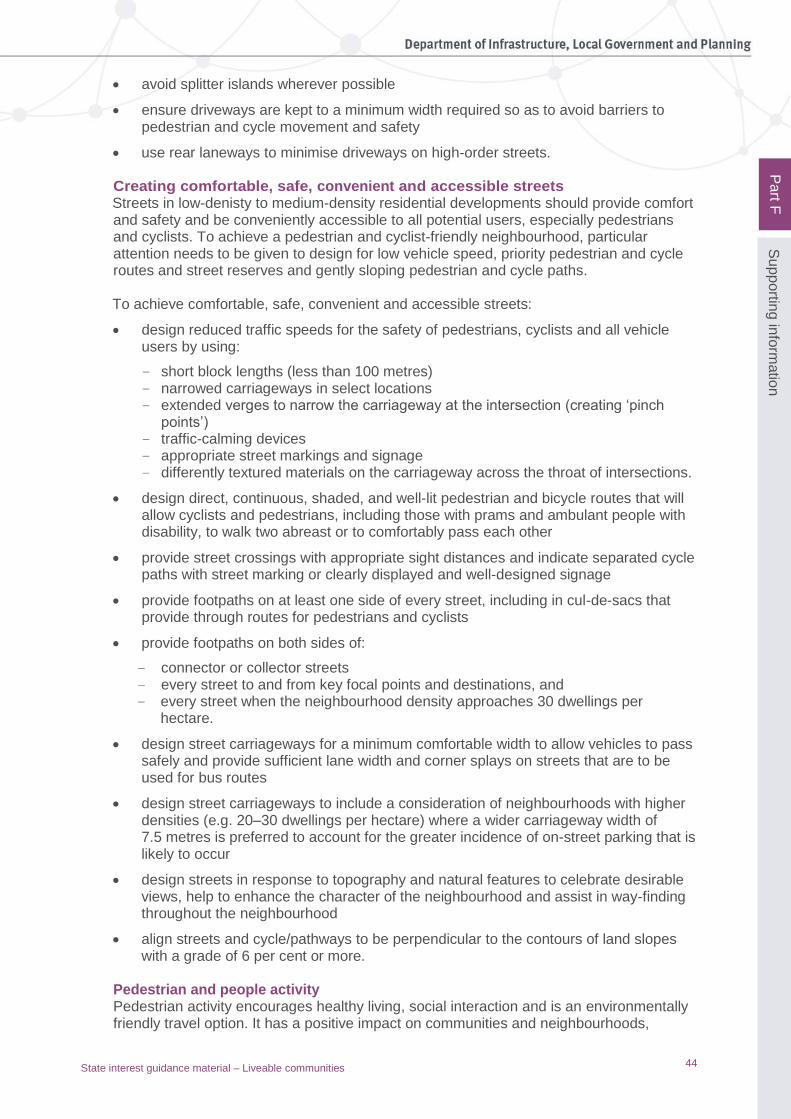
44
Pa
rt F
Su
pp
ortin
g in
form
atio
n
State interest guidance material – Liveable communities
• avoid splitter islands wherever possible
• ensure driveways are kept to a minimum width required so as to avoid barriers to pedestrian and cycle movement and safety
• use rear laneways to minimise driveways on high-order streets.
Creating comfortable, safe, convenient and accessible streets Streets in low-denisty to medium-density residential developments should provide comfort and safety and be conveniently accessible to all potential users, especially pedestrians and cyclists. To achieve a pedestrian and cyclist-friendly neighbourhood, particular attention needs to be given to design for low vehicle speed, priority pedestrian and cycle routes and street reserves and gently sloping pedestrian and cycle paths. To achieve comfortable, safe, convenient and accessible streets:
• design reduced traffic speeds for the safety of pedestrians, cyclists and all vehicle users by using:
– short block lengths (less than 100 metres) – narrowed carriageways in select locations – extended verges to narrow the carriageway at the intersection (creating ‘pinch
points’) – traffic-calming devices – appropriate street markings and signage – differently textured materials on the carriageway across the throat of intersections.
• design direct, continuous, shaded, and well-lit pedestrian and bicycle routes that will allow cyclists and pedestrians, including those with prams and ambulant people with disability, to walk two abreast or to comfortably pass each other
• provide street crossings with appropriate sight distances and indicate separated cycle paths with street marking or clearly displayed and well-designed signage
• provide footpaths on at least one side of every street, including in cul-de-sacs that provide through routes for pedestrians and cyclists
• provide footpaths on both sides of:
– connector or collector streets – every street to and from key focal points and destinations, and – every street when the neighbourhood density approaches 30 dwellings per
hectare.
• design street carriageways for a minimum comfortable width to allow vehicles to pass safely and provide sufficient lane width and corner splays on streets that are to be used for bus routes
• design street carriageways to include a consideration of neighbourhoods with higher densities (e.g. 20–30 dwellings per hectare) where a wider carriageway width of 7.5 metres is preferred to account for the greater incidence of on-street parking that is likely to occur
• design streets in response to topography and natural features to celebrate desirable views, help to enhance the character of the neighbourhood and assist in way-finding throughout the neighbourhood
• align streets and cycle/pathways to be perpendicular to the contours of land slopes with a grade of 6 per cent or more.
Pedestrian and people activity Pedestrian activity encourages healthy living, social interaction and is an environmentally friendly travel option. It has a positive impact on communities and neighbourhoods,
45
Pa
rt F
Su
pp
ortin
g in
form
atio
n
State interest guidance material – Liveable communities
PA
RT
E
promoting vibrancy and street activities. Providing space for pedestrians alongside streets in order to facilitate pedestrian movement and create activity opportunity is essential in modern street design. Pedestrians can use streets to commute, for fitness and health activities or to access adjacent land uses, such as public parks or commercial precincts. However, people do not use streets exclusively for travelling. Other activities undertaken by people in streets include street-side dining, shopping, sitting to rest, busking and entertaining, waiting for public transport, exercising and recreation, playing, and social interaction. To achieve successful pedestrian networks:
• provide supporting infrastructure including seating, bus stops and shelters, play space, shade structures, drinking fountains, gathering space, public artwork and outdoor dining
• design continuous accessible paths to ensure equitable access for people with disability including appropriate path widths for wheelchairs, motorised mobility modes and guide animals
• provide wayfinding in the form of mobility aids and vision-impaired guidance
• refer to AS/NZS1428 4.1:2009 for detailed guidance on design for access for people with a disability.
Cycle activity Encouraging active transport modes such as cycling can be achieved by providing a safe and comfortable environment for cyclists, providing network connections, and by managing interactions with other street users. There are three general types of cyclists: commuter, long-distance and local area cyclists. Commuter and long-distance cyclists typically travel at higher speeds. Therefore, it is easier to incorporate their needs on busy streets. Local-area cyclists generally have lower skill levels and so require wider cycle lanes, separated paths and slower vehicle traffic flows. All three groups have different requirements, and in order to encourage this mode of active transport, provisions should be made while designing streets to incorporate safe and efficient cycle routes. To achieve successful cycling networks:
• cycle infrastructure and lanes to be designed in accordance with Austroads’ Guide to road design, Part 6A—Pedestrian and cyclist paths to meet the requirements of the expected user
• the layout of new streets should consider and link with existing cycle networks and provide an efficient and appropriate hierarchy of infrastructure
• provide supporting infrastructure such as end-of-trip facilities including secure parking, showers and bike lockers and bicycle-parking facilities. Planning schemes must ensure they do not deviate from the Queensland Development Code MP 4.1 Sustainable buildings, which contains the mandatory provisions for end-of-trip facilities.
Public transport activity Public transport is a key activity in successful street networks and provides a more environmentally friendly transportation option than private vehicle transport. Bus services will be the predominant public transport mode using the street network; however, provisions should be made for taxi services in appropriate locations such as centres.

46
Pa
rt F
Su
pp
ortin
g in
form
atio
n
State interest guidance material – Liveable communities
Street design should provide public transport routes that integrate with the greater public transport network and with local pedestrian and cycle networks to increase use of public transport. Service coverage and access need to be integrated into the street and movement design of neighbourhoods, to enable effective public transport use. To achieve successful public transport networks:
• provide maximised service coverage and include, as a minimum, peak-hour bus lanes on key routes (where applicable to the local context)
• design streetscapes to incorporate space for bus stopping bays and indent stops to decrease the conflict between buses and other vehicles
• include supporting infrastructure including signage, stops and shelters
• integrate with other transport modes including access to taxi services where appropriate and through the provision of bike-parking facilities.
Motor vehicle activity Street design for motor vehicle activity must provide for the safe movement of motor vehicles and access to property while managing traffic speed to ensure the safety of all street users. Providing adequate capacity for anticipated use is a major design consideration, as well as designing streets to passively control the speed of motor vehicle traffic and reduce unnecessary motor vehicle movements (i.e. rat running). Motor vehicles travelling at lower speeds are more safely able to integrate with other street users and transport modes. Speed control is achieved through speed limits and, where appropriate, should be built into street geometry by designing streets and networks to have short straights and short distances between intersections, lane widths, streetscaping and on-street parking. Refer to the section above on creating comfortable, safe, convenient and accessible streets. A key objective of street design is to provide access to adjoining properties. Access must be controlled in certain environments (such as streets with high levels of pedestrian activity) where it is desirable to reduce the interaction between turning vehicles and other street users. For detailed guidance, refer to Austroads’ Guide to road design. Parking Parking for motor vehicles is a major consideration for street design. Key objectives are:
• avoid obstructing other street users
• balance supply and demand of parking requirements
• minimise parking
• provide accessible parking, managing parking zones and time limits to impact positively on the street vibrancy and on other street users.
Parking can be classified into two categories: on-street and on-site. On-street parking can be uncontrolled, or controlled via time limits or metering, influencing vehicle turnover. On-site parking is required to be provided in accordance with the local government regulations. In high-activity areas and other appropriate locations, parking lane space should also accommodate taxi stands. Motorcycle and motor scooter parking spaces may be provided at locations according to forecast demand. Provision must be made for commercial loading/delivery vehicles as

47
Pa
rt F
Su
pp
ortin
g in
form
atio
n
State interest guidance material – Liveable communities
well as waste collection vehicles. Parking lane widths must be sufficient to avoid obstruction of other street users, such as cyclists in adjoining cycle lanes. For more detailed guidance, refer to AS 2890.1 for off-street car parking, AS2890.5 for on-street parking, and the Queensland manual of uniform traffic control devices (MUTCD), produced by the Department of Transport and Main Roads: www.tmr.qld.gov.au/business-industry/Technical- standards-publications/Manual-of-uniform-traffic-control- devices.aspx and www.tmr.qld.gov.au/business-industry/Technical-standards-publications/Manual-of-uniform-traffic-control-devices.aspx

48
Pa
rt F
Su
pp
ortin
g in
form
atio
n
State interest guidance material – Liveable communities
5. Planning for infrastructure and community facilities
Types of Infrastructure ‘Hard’ infrastructure is commonly known as the physical networks necessary for a community to function, including:
• transportation infrastructure (e.g. airports, ports, roads, rail, public transport, pedestrian and cycle networks and facilities)
• utilities (e.g. water, energy, sewerage)
• telecommunication infrastructure (e.g. high-speed internet, telephone, radio and television).
‘Soft’ infrastructure is commonly known as the facilities and institutions necessary for a community to prosper and thrive, including:
• education (e.g. schools, universities and training institutions)
• health (e.g. private and public hospitals, emergency services and retirement and aged facilities)
• justice and correctional facilities
• sports and recreation facilities (parks, sporting grounds, stadiums, and cultural facilities).
While generally considered to be provided by government, social infrastructure can also be provided by the not-for-profit sector or private organisations and institutions. Examples of this include faith-based schools or health facilities. School infrastructure demand maps are available from the Queensland Government Statistician’s Office (QGSO).3 The maps show projected change in school-age population and will help to determine where new primary and secondary schools may need to be built, or existing schools expanded, over the next 20 years. The school infrastructure planning data can be used to efficiently identify and allocate land within a local government planning area for a future school.
The need for social infrastructure, and community services and facilities
Social infrastructure – and the community services, facilities and social networks it helps foster – is fundamental to the wellbeing of communities. Social infrastructure encourages people to take part in community life, builds belonging, reduces social isolation, and meets basic individual and family needs. It includes infrastructure that is available to all (e.g. education, health, arts, culture and community facilities), infrastructure targeted at people in different stages of life (e.g. children, young people, seniors, the mobility impaired and people with disability), and infrastructure targeted at groups with special needs (e.g. families, people with a disability, Indigenous people, and culturally and linguistically diverse people). In a high-density setting, community facilities and open space can also supplement the role of the private home by providing places for celebrations and gatherings (e.g. affordable venues for children’s birthday parties). Social infrastructure needs to be available to communities early in their formation to support the practical needs of residents and workers including access to childcare or venues for fitness, craft and other recreational activities.
3 The maps are available at www.qgso.qld.gov.au/products/maps/schools-infrastructure-demand-maps-
2015/index.php

49
Pa
rt F
Su
pp
ortin
g in
form
atio
n
State interest guidance material – Liveable communities
The planning and provision of social infrastructure in neighbourhoods and communities plays an important role in the development of new communities, and supporting the needs of residents and workers.
Providing community facilities
A local government may require a developer to prepare a community development strategy in conjunction with a large-scale development application, such as a master-planned community. The community development strategy may include:
• a community facilities plan and program to guide future development decisions and implementation, including the early provision and longer term sequencing of community facilities and services as well as the exploration of alternative and innovative solutions such as schools as community hubs, and/or
• a community development program including key objectives, initiatives and targets, and implementation mechanisms and resources.
Supporting community diversity through provision of infrastructure
To help achieve community diversity:
• Where a social infrastructure plan is required as part of the planning process, identify for both existing and new communities: – the type of built infrastructure required, its size and location, preferred timing and
the agency responsible for its development – the community services that need to be established in built facilities, and cultural
and community development strategies required to support the emerging community
– performance outcomes or standards of provision to ensure appropriateness for the intended purpose, including design, land-use compatibility and function.
• Provide a base level of community infrastructure at the outset to support the early stages of the development (e.g. childcare centres, schools, community centres, information and welcoming programs), complemented by the staged provision of infrastructure as the population grows.
For further information regarding planning social infrastructure, refer to the
implementation guideline No. 5 – Social infrastructure planning, which can be found at
www.dilgp.qld.gov.au/resources/guideline/ImplementationGuideline5.pdf
Note: The State Infrastructure Plan (2016) has committed to the production of five strategic
documents, including a strategy for social infrastructure. The document is currently being
drafted and is expected to be released in late 2017. When publicly available this document will
replace the implementation guideline No. 5 – Social infrastructure planning.
Principles of providing community facilities
1. Innovation and value for money Demonstrate how innovation, efficiency and value for money will maximise the use of the resources required to meet community needs and deliver sustainable outcomes, through:
• using partnerships and formal agreements between public, private and community organisations and landowners, including state and non-state education providers
• facilitating early delivery of facilities and services rather than a land-only contribution
• co-locating facilities and sharing resources and spaces, including sports facilities, for state and non-state schools

50
Pa
rt F
Su
pp
ortin
g in
form
atio
n
State interest guidance material – Liveable communities
• multi-purpose and multi-functional spaces and places that can be used for a wide range of community uses and can be adapted to changing uses over time
• efficient use of land
• innovative design.
2. Early provision of facilities Meet the needs of incoming residents through early provision of facilities in the formative stages of the community in order to contribute to a sense of place and belonging. This is particularly important in greenfield areas and in locations where there is limited access to existing facilities and services. 3. Community hubs and precincts Consider the co-location of facilities including open space in hubs and precincts to provide the community access to multiple services in a single location that facilitates enhanced and integrated service delivery and provides a focus for community activity. 4. Optimising accessibility Locate community facilities in a highly visible location in centres within walkable catchments, with good access to public transport, shops and meeting places and spaces to encourage social gathering and community building. The design, location and management of these community facilities will ensure safe, inclusive and convenient access for communities and individuals of all user groups and levels of ability. 5. A network that meets identified needs Community facilities contribute to a broader network and hierarchy of facilities. The nature and distribution of facilities in a local government area should:
• contribute to equitable provision across the network
• be provided at an appropriate scale in a hierarchy of centres
• address deficiencies, needs and priorities in the local government and its surrounding community
• re-use underutilised spaces and places, where available, as focal points for community activity.
6. Design The design of community facilities will be guided by the function, the place, and the requirements of government and community organisations. A community facility should also be guided by its location, the make-up of its community, the physical environment, climate and local culture. Some factors to consider are:
• contribution to the public domain and sense of place – integrates with streets and footpaths, connects with adjoining buildings and spaces, creates small public spaces to avoid unused spaces, contributes to public safety
• contribution to health and wellbeing – creates shade, provides places for social interaction, incorporates nature, allows natural light, and avoids or minimises exposure to chronic noise
• response to the environmental context – incorporates or reflects local cultural places or natural features, enhances local landscape, reflects vernacular built form and materials
• visibility and accessibility – connectivity signage for way-finding, signage to identify uses of a facility, adequate lighting

51
Pa
rt F
Su
pp
ortin
g in
form
atio
n
State interest guidance material – Liveable communities
• function – flexible design that also considers the needs of people with disability, children, young people and seniors, adequate storage for multiple uses, car parking, and bicycle storage.
Green Star Communities – Framework and rating tool
For further information regarding urban design and liveable communities, refer to Green star communities: Guide for local government www.gbca.org.au/uploads/189/2749/Green_Star_Communities_Guide_for_Local_Government_For_Web.pdf.

State Planning Policy PO Box 15009 City East Qld 4002 tel 13 QGOV (13 74 68) email [email protected]
www.dilgp.qld.gov.au