Embed Size (px)
Citation preview

Important Note Existing water rights for stock and individual domestic uses from instream or groundwater sources were exempted from the filing requirements of § 85-2-221, MCA. An existing water right is a water right first put to beneficial use prior to July 1, 1973.
In 2017, the Montana Legislature passed House Bill 110, allowing the filing for existing water rights that were exempt from filing in the statewide water right adjudication, and set a filing deadline to be received or postmarked on or before June 30, 2019.
House Bill 110 requires that you complete this claim form, include supporting documentation for your claim (e.g., maps, affidavits, decrees, notices of appropriation or completion, etc.), and pay the filing fee set out above.
1. WATER RIGHT OWNER INFORMATION:NAME(S) ____________________________________________________________________________________________________________MAILING ADDRESS ____________________________________________________________________________________________________CITY _________________________________ STATE ________________________ ZIP______________________________WORK PHONE _______________________ HOME PHONE____________________ CELL PHONE_____________________
2. PERSON COMPLETING FORM: Same as above? Yes No If yes, proceed to #3. NAME ____________________________________________________________________________________________________________ MAILING ADDRESS ____________________________________________________________________________________________________CITY _________________________________ STATE ________________________ ZIP______________________________WORK PHONE _______________________ HOME PHONE____________________ CELL PHONE_____________________
3. SOURCE OF WATER: Choose only one: Developed Spring Well Stream Lake Name of Source (if applicable) ___________________________ Tributary of _________________________
STATEMENT OF CLAIM FOR EXISTING WATER RIGHT
EXEMPT STOCK USE Use this form to claim an existing water right exempt
from the claim filing process. § 85-2-222, MCA
Filing / Examination Fee
The total filing fees for all claims under 85-2-222 filed by one person in any one water court division may not exceed $1,560.
A filing fee is not required to accompany a claim or an existing right that is included in a decree of a court in the state of Montana and that is accompanied by a copy of that decree or pertinent portion of the decree.
FOR DEPARTMENT USE ONLY
Claim No. _________________ Basin _________________
Date Rec’d ________________ Time ___________AM - PM
Rec'd By _______________________________________
Fee Rec'd $ ____________ Check No. _____________
Deposit Receipt # __________________________________
Payor (if different from name(s) listed in item 1 below) __________________________________________________
Refund $ ______________ Date __________________
Page 1 of 2
Undeveloped Spring
1 Claim = $130
4. SOURCE TYPE: Groundwater Surface Water
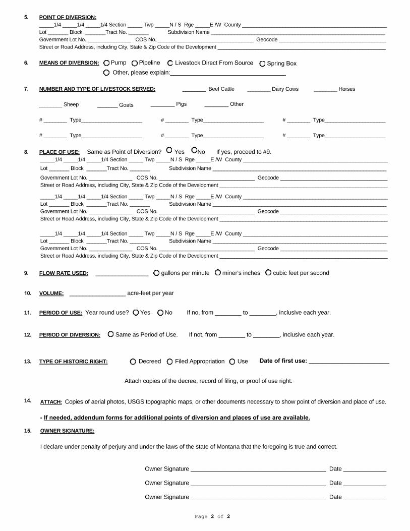
6. MEANS OF DIVERSION: Pump Pipeline Livestock Direct From Source Other, please explain:___________________________________
7. NUMBER AND TYPE OF LIVESTOCK SERVED: ________ Beef Cattle
________ Sheep
________ Dairy Cows ________ Horses
# ________ Type_____________________ # ________ Type_____________________ # ________ Type_____________________
# ________ Type_____________________ # ________ Type_____________________ # ________ Type_____________________
8. PLACE OF USE: Same as Point of Diversion? Yes No If yes, proceed to #9._____1/4 _____1/4 _____1/4 Section _____ Twp _____N / S Rge _____E /W County __________________________________________________Lot _______ Block _______Tract No. _______ Subdivision Name ____________________________________________________________
Government Lot No. _______________ COS No. _________________________________ Geocode _____________________________________Street or Road Address, including City, State & Zip Code of the Development __________________________________________________________
_____1/4 _____1/4 _____1/4 Section _____ Twp _____N / S Rge _____E /W County __________________________________________________Lot _______ Block _______Tract No. _______ Subdivision Name ____________________________________________________________Government Lot No. _______________ COS No. _________________________________ Geocode _____________________________________Street or Road Address, including City, State & Zip Code of the Development __________________________________________________________
_____1/4 _____1/4 _____1/4 Section _____ Twp _____N / S Rge _____E /W County __________________________________________________Lot _______ Block _______Tract No. _______ Subdivision Name ____________________________________________________________Government Lot No. _______________ COS No. _________________________________ Geocode _____________________________________Street or Road Address, including City, State & Zip Code of the Development __________________________________________________________
9. FLOW RATE USED: ________________ gallons per minute miner’s inches cubic feet per second
10. VOLUME: _________________ acre-feet per year
11. PERIOD OF USE: Year round use? Yes No If no, from ________ to ________, inclusive each year.
12. PERIOD OF DIVERSION: Same as Period of Use. If not, from ________ to ________, inclusive each year.
13. TYPE OF HISTORIC RIGHT: Decreed Filed Appropriation Use
Attach copies of the decree, record of filing, or proof of use right.
14.
15. OWNER SIGNATURE:
I declare under penalty of perjury and under the laws of the state of Montana that the foregoing is true and correct.
Owner Signature _________________________________________ Date _____________
Owner Signature _________________________________________ Date _____________
Owner Signature _________________________________________ Date _____________
Page 2 of 2
Spring Box
5. POINT OF DIVERSION:_____1/4 _____1/4 _____1/4 Section _____ Twp _____N / S Rge _____E /W County __________________________________________________Lot _______ Block _______Tract No. _______ Subdivision Name ____________________________________________________________Government Lot No. _______________ COS No. _________________________________ Geocode _____________________________________Street or Road Address, including City, State & Zip Code of the Development __________________________________________________________
ATTACH: Copies of aerial photos, USGS topographic maps, or other documents necessary to show point of diversion and place of use.
- If needed, addendum forms for additional points of diversion and places of use are available.
_______ Goats ________ Pigs ________ Other
Date of first use: ________________________