Embed Size (px)
Citation preview
GOFC/GOLD 2nd Geo Fire Workshop, EUMETSAT, Dec. 4-6, 2006
Status and Plans for Global Geostationary Fire Status and Plans for Global Geostationary Fire Detection and Monitoring with the WF_ABBADetection and Monitoring with the WF_ABBA
Elaine M. PrinsChristopher C. Schmidt
Jason BrunnerScott LindstromJoleen M. Feltz
Jay Hoffman
UW-Madison SSECCooperative Institute for
Meteorological Satellite Studies
UW-MadisonCooperative Institute for Meteorological Satellite Studies (CIMSS)
National Aeronauticsand Space Administration
NOAA/NESDIS/STAR/CORPAdvanced Satellite Products Branch (ASPB)
GOFC/GOLD 2nd Geo Fire Workshop, EUMETSAT, Dec. 4-6, 2006
Current Projects and Collaborations
Trend analysis work in the Western Hemisphere
Reprocessing effort in South America for NASA LBA (1995 – 1999) for long-term fire dynamics study (1995 – current).
Collaborations with several air quality and aerosol transport modeling groups: (NRL-Monterey, INPE CPTEC, Univ. of Alabama Huntsville, Harvard Univ., NCAR Atmos. Chem. Division, etc.)
MODIS/GOES fire product comparisons
Collaborations with air quality and emissions groups (EPA, WRAP, Infusing satellite Data into Environmental Applications (IDEA), local air quality districts)
Fire Weather and Rapid Scan Applications
Development of a global geostationary fire monitoring network with transfer to NOAA/NESDIS operations (HMS).
Algorithm updates
GOES-R ABI research and development (launch 2014)
GOFC/GOLD 2nd Geo Fire Workshop, EUMETSAT, Dec. 4-6, 2006
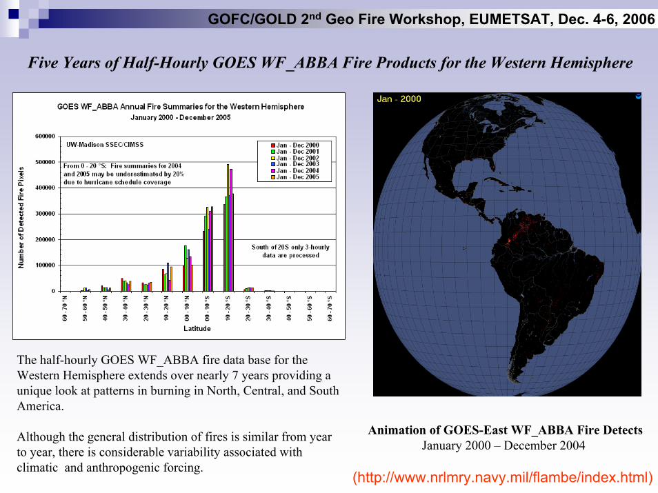
Five Years of Half-Hourly GOES WF_ABBA Fire Products for the Western Hemisphere
The half-hourly GOES WF_ABBA fire data base for the Western Hemisphere extends over nearly 7 years providing a unique look at patterns in burning in North, Central, and South America.
Although the general distribution of fires is similar from year to year, there is considerable variability associated with climatic and anthropogenic forcing.
Animation of GOES-East WF_ABBA Fire DetectsJanuary 2000 – December 2004
(http://www.nrlmry.navy.mil/flambe/index.html)
GOFC/GOLD 2nd Geo Fire Workshop, EUMETSAT, Dec. 4-6, 2006
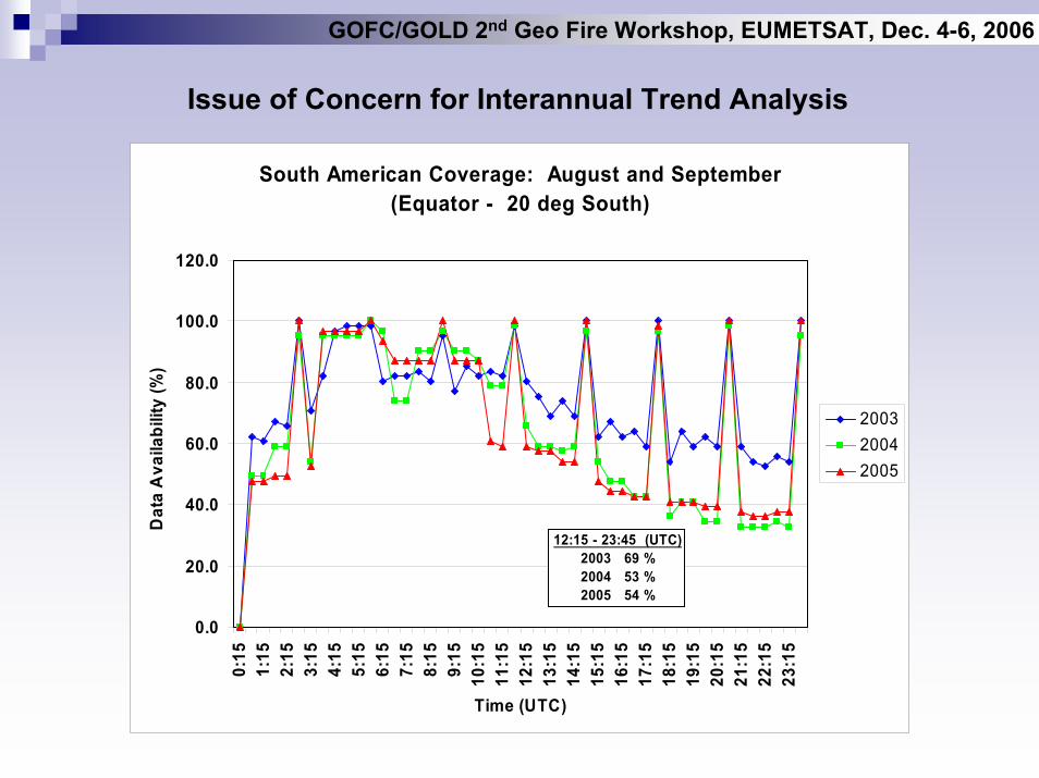
Issue of Concern for Interannual Trend Analysis
South American Coverage: August and September(Equator - 20 deg South)
0.0
20.0
40.0
60.0
80.0
100.0
120.00:
151:
152:
153:
154:
155:
156:
157:
158:
159:
1510
:15
11:1
512
:15
13:1
514
:15
15:1
516
:15
17:1
518
:15
19:1
520
:15
21:1
522
:15
23:1
5
Time (UTC)
Dat
a A
vaila
bilit
y (%
)
200320042005
12:15 - 23:45 (UTC)2003 69 %2004 53 %2005 54 %
GOFC/GOLD 2nd Geo Fire Workshop, EUMETSAT, Dec. 4-6, 2006
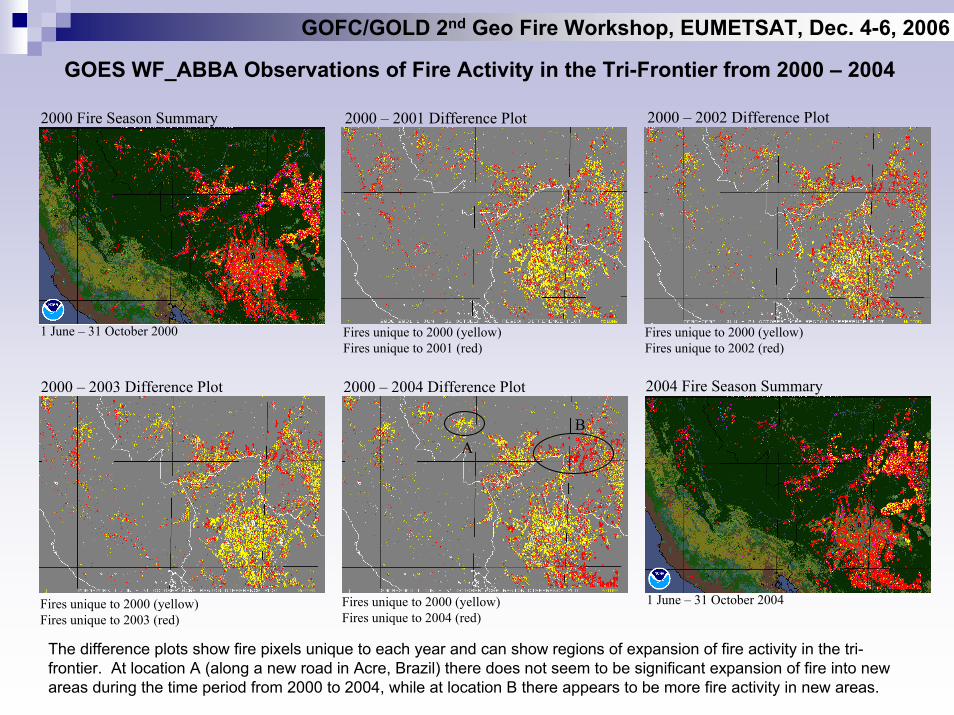
GOES WF_ABBA Observations of Fire Activity in the Tri-Frontier from 2000 – 2004
2000 – 2001 Difference Plot 2000 – 2002 Difference Plot2000 Fire Season Summary
Fires unique to 2000 (yellow)Fires unique to 2001 (red)
Fires unique to 2000 (yellow)Fires unique to 2002 (red)
1 June – 31 October 2000
1 June – 31 October 2004
2004 Fire Season Summary2000 – 2003 Difference Plot 2000 – 2004 Difference Plot
Fires unique to 2000 (yellow)Fires unique to 2003 (red)
Fires unique to 2000 (yellow)Fires unique to 2004 (red)
AB
The difference plots show fire pixels unique to each year and can show regions of expansion of fire activity in the tri-frontier. At location A (along a new road in Acre, Brazil) there does not seem to be significant expansion of fire into new areas during the time period from 2000 to 2004, while at location B there appears to be more fire activity in new areas.
GOFC/GOLD 2nd Geo Fire Workshop, EUMETSAT, Dec. 4-6, 2006
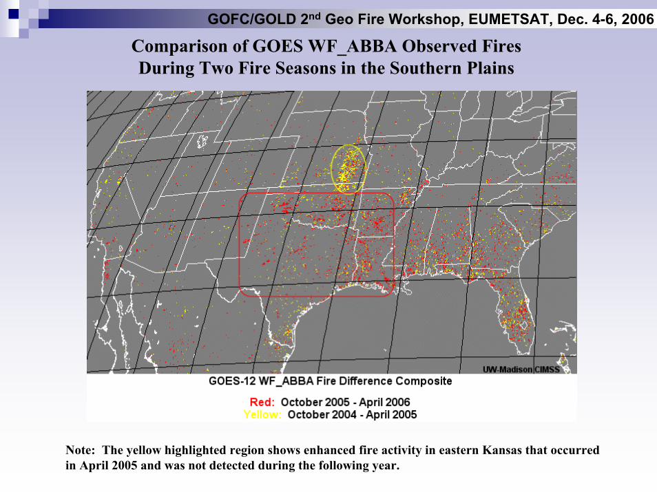
Comparison of GOES WF_ABBA Observed Fires During Two Fire Seasons in the Southern Plains
Note: The yellow highlighted region shows enhanced fire activity in eastern Kansas that occurred in April 2005 and was not detected during the following year.
GOFC/GOLD 2nd Geo Fire Workshop, EUMETSAT, Dec. 4-6, 2006
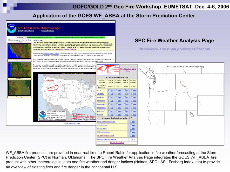
Application of the GOES WF_ABBA at the Storm Prediction Center
SPC Fire Weather Analysis Pagehttp://www.spc.noaa.gov/exper/firecom
WF_ABBA fire products are provided in near real time to Robert Rabin for application in fire weather forecasting at the Storm Prediction Center (SPC) in Norman, Oklahoma. The SPC Fire Weather Analysis Page integrates the GOES WF_ABBA fire product with other meteorological data and fire weather and danger indices (Haines, SPC LASI, Fosberg Index, etc) to provide an overview of existing fires and fire danger in the continental U.S.
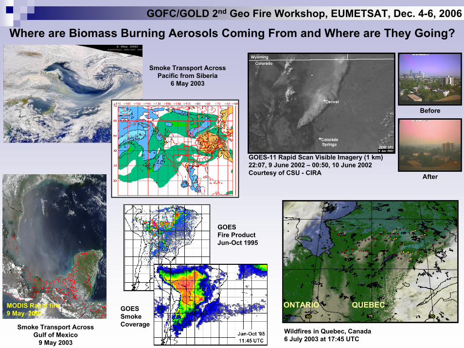
Where are Biomass Burning Aerosols Coming From and Where are They Going?
Smoke Transport AcrossPacific from Siberia
6 May 2003
MODIS Rapid fire9 May 2003
Smoke Transport Across Gulf of Mexico
9 May 2003
QUEBECONTARIO
Wildfires in Quebec, Canada6 July 2003 at 17:45 UTC
GOES-11 Rapid Scan Visible Imagery (1 km)22:07, 9 June 2002 – 00:50, 10 June 2002Courtesy of CSU - CIRA
Before
After
GOES Fire ProductJun-Oct 1995
GOES SmokeCoverage
GOFC/GOLD 2nd Geo Fire Workshop, EUMETSAT, Dec. 4-6, 2006
GOFC/GOLD 2nd Geo Fire Workshop, EUMETSAT, Dec. 4-6, 2006
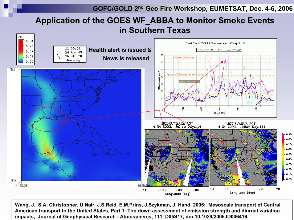
Application of the GOES WF_ABBA to Monitor Smoke Events Application of the GOES WF_ABBA to Monitor Smoke Events in Southern Texasin Southern Texas
Health alert is issued &Health alert is issued &News is releasedNews is released
Wang, J., S.A. Christopher, U.Nair, J.S.Reid, E.M.Prins, J.Szykman, J. Hand, 2006: Mesoscale transport of Central American transport to the United States, Part 1: Top down assessment of emission strength and diurnal variation impacts, Journal of Geophysical Research - Atmospheres, 111, D05S17, doi:10.1029/2005JD006416.
GOFC/GOLD 2nd Geo Fire Workshop, EUMETSAT, Dec. 4-6, 2006
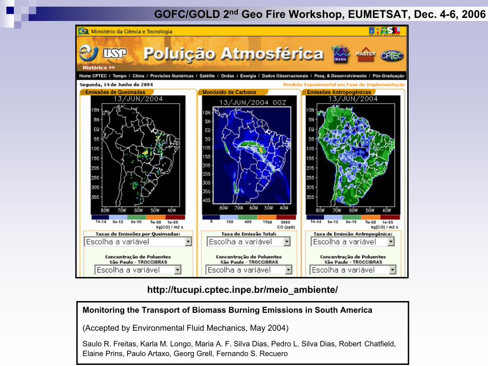
http://tucupi.cptec.inpe.br/meio_ambiente/
Monitoring the Transport of Biomass Burning Emissions in South America
(Accepted by Environmental Fluid Mechanics, May 2004)
Saulo R. Freitas, Karla M. Longo, Maria A. F. Silva Dias, Pedro L. Silva Dias, Robert Chatfield, Elaine Prins, Paulo Artaxo, Georg Grell, Fernando S. Recuero
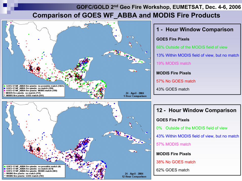
Comparison of GOES WF_ABBA and MODIS Fire Products
1 - Hour Window ComparisonGOES Fire Pixels
68% Outside of the MODIS field of view
13% Within MODIS field of view, but no match
19% MODIS match
MODIS Fire Pixels
57% No GOES match
43% GOES match
12 - Hour Window ComparisonGOES Fire Pixels
0% Outside of the MODIS field of view
43% Within MODIS field of view, but no match
57% MODIS match
MODIS Fire Pixels
38% No GOES match
62% GOES match
GOFC/GOLD 2nd Geo Fire Workshop, EUMETSAT, Dec. 4-6, 2006
GOFC/GOLD 2nd Geo Fire Workshop, EUMETSAT, Dec. 4-6, 2006
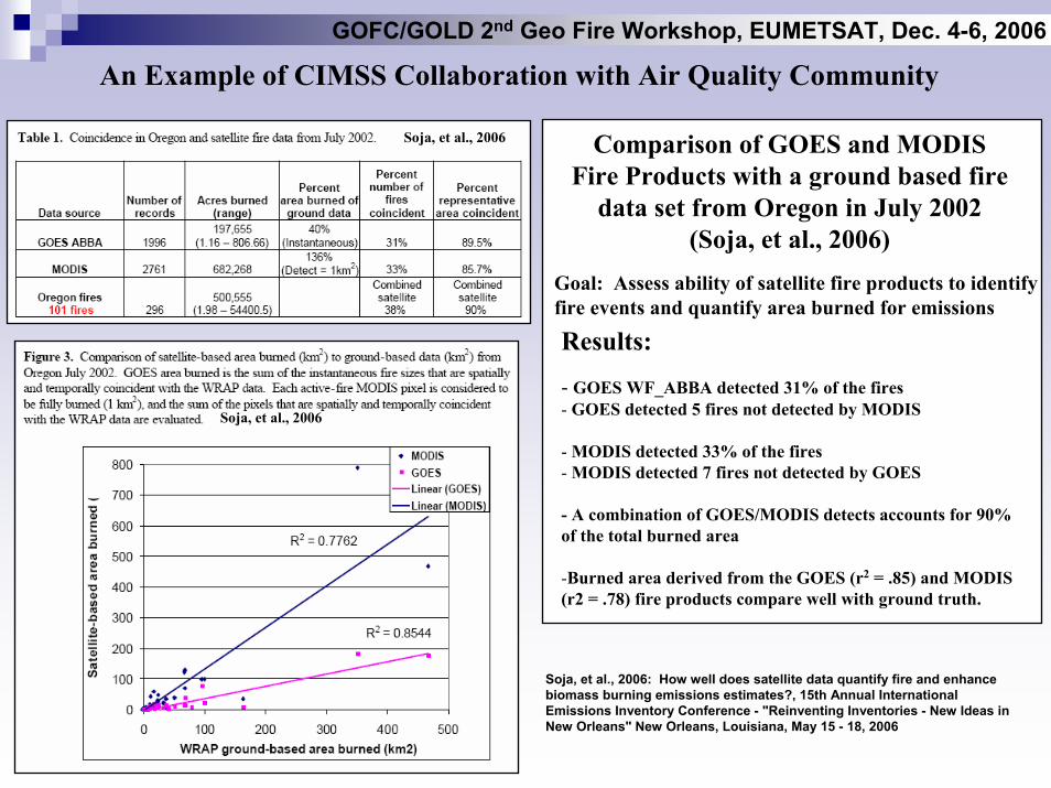
An Example of CIMSS Collaboration with Air Quality Community
Comparison of GOES and MODISFire Products with a ground based fire
data set from Oregon in July 2002(Soja, et al., 2006)
Goal: Assess ability of satellite fire products to identify fire events and quantify area burned for emissions
Results:
- GOES WF_ABBA detected 31% of the fires- GOES detected 5 fires not detected by MODIS
- MODIS detected 33% of the fires- MODIS detected 7 fires not detected by GOES
- A combination of GOES/MODIS detects accounts for 90% of the total burned area
-Burned area derived from the GOES (r2 = .85) and MODIS (r2 = .78) fire products compare well with ground truth.
Soja, et al., 2006
Soja, et al., 2006
Soja, et al., 2006: How well does satellite data quantify fire and enhance biomass burning emissions estimates?, 15th Annual International Emissions Inventory Conference - "Reinventing Inventories - New Ideas in New Orleans" New Orleans, Louisiana, May 15 - 18, 2006
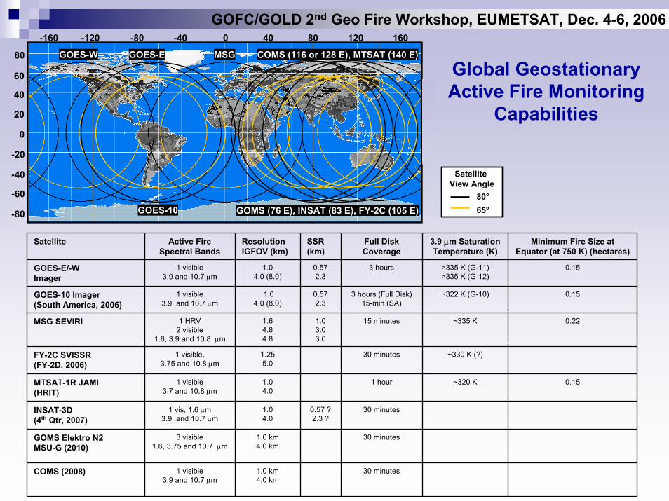
Global GeostationaryActive Fire Monitoring
Capabilities
Satellite View Angle
80°65°
0-40-80-120-160 40 80 120
80
60
40
20
0
-20
-40
-60
-80
GOES-EGOES-W MSG COMS (116 or 128 E), MTSAT (140 E)
160
GOMS (76 E), INSAT (83 E), FY-2C (105 E)GOES-10
GOFC/GOLD 2nd Geo Fire Workshop, EUMETSAT, Dec. 4-6, 2006
Satellite Active Fire Spectral Bands
Resolution IGFOV (km)
SSR (km)
Full Disk Coverage
3.9 µm SaturationTemperature (K)
Minimum Fire Size at Equator (at 750 K) (hectares)
GOES-E/-WImager
1 visible3.9 and 10.7 µm
1.04.0 (8.0)
0.572.3
3 hours >335 K (G-11)>335 K (G-12)
0.15
GOES-10 Imager(South America, 2006)
1 visible3.9 and 10.7 µm
1.04.0 (8.0)
0.572.3
3 hours (Full Disk)15-min (SA)
~322 K (G-10) 0.15
MSG SEVIRI 1 HRV2 visible
1.6, 3.9 and 10.8 µm
1.6 4.84.8
1.0 3.03.0
15 minutes ~335 K 0.22
FY-2C SVISSR(FY-2D, 2006)
1 visible,3.75 and 10.8 µm
1.255.0
30 minutes ~330 K (?)
MTSAT-1R JAMI(HRIT)
1 visible3.7 and 10.8 µm
1.04.0
1 hour ~320 K 0.15
INSAT-3D(4th Qtr, 2007)
1 vis, 1.6 µm3.9 and 10.7 µm
1.04.0
0.57 ?2.3 ?
30 minutes
GOMS Elektro N2MSU-G (2010)
3 visible1.6, 3.75 and 10.7 µm
1.0 km4.0 km
30 minutes
COMS (2008) 1 visible3.9 and 10.7 µm
1.0 km4.0 km
30 minutes
GOFC/GOLD 2nd Geo Fire Workshop, EUMETSAT, Dec. 4-6, 2006
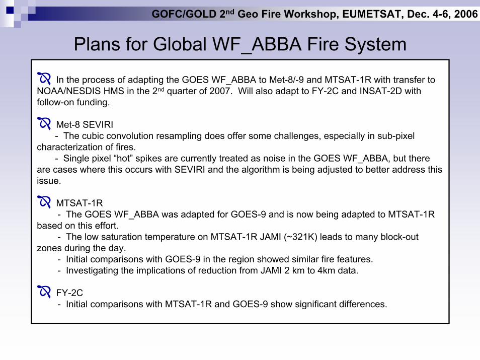
Plans for Global WF_ABBA Fire System
In the process of adapting the GOES WF_ABBA to Met-8/-9 and MTSAT-1R with transfer to NOAA/NESDIS HMS in the 2nd quarter of 2007. Will also adapt to FY-2C and INSAT-2D with follow-on funding.
Met-8 SEVIRI- The cubic convolution resampling does offer some challenges, especially in sub-pixel
characterization of fires.- Single pixel “hot” spikes are currently treated as noise in the GOES WF_ABBA, but there
are cases where this occurs with SEVIRI and the algorithm is being adjusted to better address this issue.
MTSAT-1R- The GOES WF_ABBA was adapted for GOES-9 and is now being adapted to MTSAT-1R
based on this effort.- The low saturation temperature on MTSAT-1R JAMI (~321K) leads to many block-out
zones during the day.- Initial comparisons with GOES-9 in the region showed similar fire features.- Investigating the implications of reduction from JAMI 2 km to 4km data.
FY-2C- Initial comparisons with MTSAT-1R and GOES-9 show significant differences.
GOFC/GOLD 2nd Geo Fire Workshop, EUMETSAT, Dec. 4-6, 2006
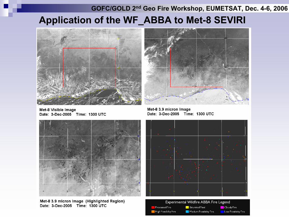
Application of the WF_ABBA to Met-8 SEVIRI
GOFC/GOLD 2nd Geo Fire Workshop, EUMETSAT, Dec. 4-6, 2006
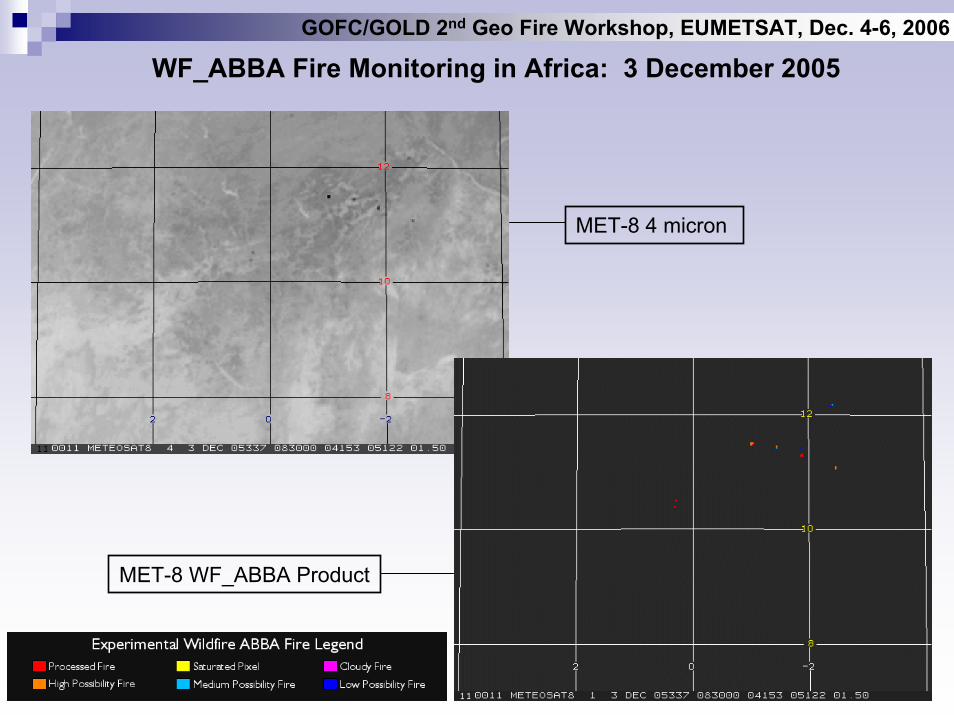
WF_ABBA Fire Monitoring in Africa: 3 December 2005
MET-8 4 micron
MET-8 WF_ABBA Product
GOFC/GOLD 2nd Geo Fire Workshop, EUMETSAT, Dec. 4-6, 2006
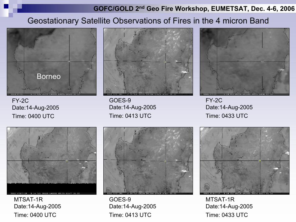
Geostationary Satellite Observations of Fires in the 4 micron Band
Borneo
GOES-9Date:14-Aug-2005Time: 0413 UTC
FY-2CDate:14-Aug-2005Time: 0433 UTC
FY-2CDate:14-Aug-2005Time: 0400 UTC
MTSAT-1RDate:14-Aug-2005Time: 0400 UTC
GOES-9Date:14-Aug-2005Time: 0413 UTC
MTSAT-1RDate:14-Aug-2005Time: 0433 UTC
GOFC/GOLD 2nd Geo Fire Workshop, EUMETSAT, Dec. 4-6, 2006
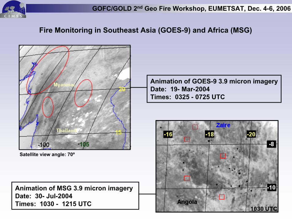
Fire Monitoring in Southeast Asia (GOES-9) and Africa (MSG)
-
Animation of GOES-9 3.9 micron imageryDate: 19- Mar-2004Times: 0325 - 0725 UTC
Animation of MSG 3.9 micron imageryDate: 30- Jul-2004Times: 1030 - 1215 UTC
Satellite view angle: 70º
GOFC/GOLD 2nd Geo Fire Workshop, EUMETSAT, Dec. 4-6, 2006
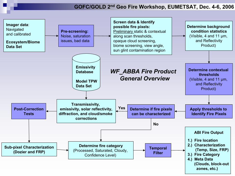
WF_ABBA Fire Product General Overview
Imager data: Navigatedand calibrated
Ecosystem/Biome Data Set
Pre-screening:Noise, saturation issues, bad data
Screen data & Identify possible fire pixels:Preliminary static & contextual along scan thresholds, opaque cloud screening, biome screening, view angle, sun glint contamination region
Determine background condition statistics
(Visible, 4 and 11 µm, and Reflectivity
Product)
Determine contextual thresholds
(Visible, 4 and 11 µm, and Reflectivity
Product)
Apply thresholds to Identify Fire Pixels
Determine if fire pixelscan be characterized
Transmissivity, emissivity, solar reflectivity,
diffraction, and cloud/smoke corrections
EmissivityDatabase
Model TPW Data Set
Post-CorrectionTests
Sub-pixel Characterization(Dozier and FRP)
Determine fire category(Processed, Saturated, Cloudy,
Confidence Level)
TemporalFilter
ABI Fire Output
1.) Fire location2.) Characterization
(Temp, Size, FRP)3.) Fire Category4.) Meta Data
(Clouds, block-outzones, etc.)
Yes
No
GOFC/GOLD 2nd Geo Fire Workshop, EUMETSAT, Dec. 4-6, 2006
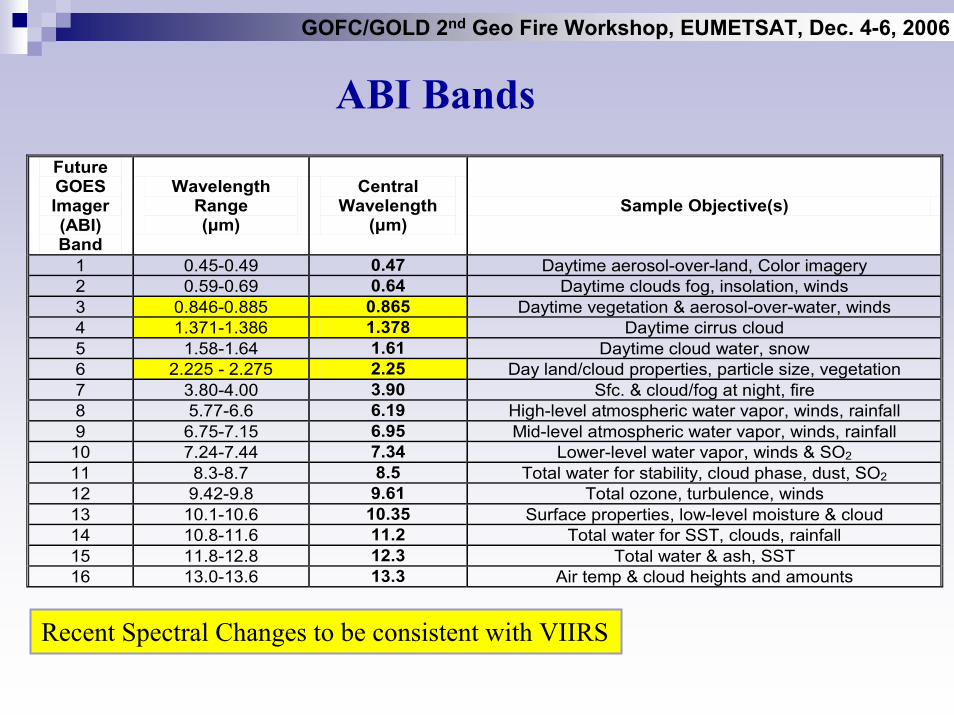
ABI BandsFuture GOES Imager (ABI) Band
Wavelength Range (µm)
Central Wavelength
(µm) Sample Objective(s)
1 0.45-0.49 0.47 Daytime aerosol-over-land, Color imagery 2 0.59-0.69 0.64 Daytime clouds fog, insolation, winds 3 0.846-0.885 0.865 Daytime vegetation & aerosol-over-water, winds 4 1.371-1.386 1.378 Daytime cirrus cloud 5 1.58-1.64 1.61 Daytime cloud water, snow 6 2.225 - 2.275 2.25 Day land/cloud properties, particle size, vegetation 7 3.80-4.00 3.90 Sfc. & cloud/fog at night, fire 8 5.77-6.6 6.19 High-level atmospheric water vapor, winds, rainfall 9 6.75-7.15 6.95 Mid-level atmospheric water vapor, winds, rainfall
10 7.24-7.44 7.34 Lower-level water vapor, winds & SO2 11 8.3-8.7 8.5 Total water for stability, cloud phase, dust, SO2 12 9.42-9.8 9.61 Total ozone, turbulence, winds 13 10.1-10.6 10.35 Surface properties, low-level moisture & cloud 14 10.8-11.6 11.2 Total water for SST, clouds, rainfall 15 11.8-12.8 12.3 Total water & ash, SST 16 13.0-13.6 13.3 Air temp & cloud heights and amounts
Recent Spectral Changes to be consistent with VIIRS
GOFC/GOLD 2nd Geo Fire Workshop, EUMETSAT, Dec. 4-6, 2006
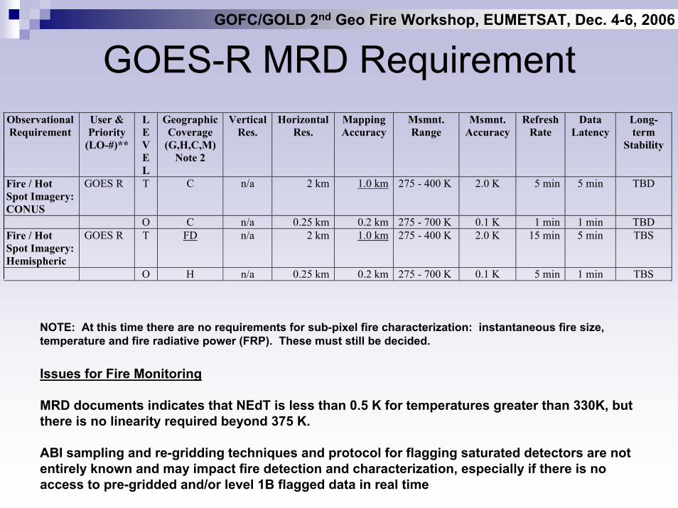
GOES-R MRD RequirementObservational Requirement
User & Priority
(LO-#)**
L E V E L
Geographic Coverage
(G,H,C,M) Note 2
Vertical Res.
Horizontal Res.
Mapping Accuracy
Msmnt. Range
Msmnt. Accuracy
Refresh Rate
Data Latency
Long-term
Stability
Fire / Hot Spot Imagery: CONUS
GOES R T C n/a 2 km 1.0 km 275 - 400 K 2.0 K 5 min 5 min TBD
O C n/a 0.25 km 0.2 km 275 - 700 K 0.1 K 1 min 1 min TBD Fire / Hot Spot Imagery: Hemispheric
GOES R T FD n/a 2 km 1.0 km 275 - 400 K 2.0 K 15 min 5 min TBS
O H n/a 0.25 km 0.2 km 275 - 700 K 0.1 K 5 min 1 min TBS
NOTE: At this time there are no requirements for sub-pixel fire characterization: instantaneous fire size, temperature and fire radiative power (FRP). These must still be decided.
Issues for Fire Monitoring
MRD documents indicates that NEdT is less than 0.5 K for temperatures greater than 330K, but there is no linearity required beyond 375 K.
ABI sampling and re-gridding techniques and protocol for flagging saturated detectors are not entirely known and may impact fire detection and characterization, especially if there is no access to pre-gridded and/or level 1B flagged data in real time
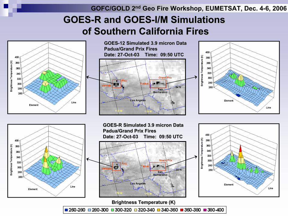
GOESGOES--R and GOESR and GOES--I/M Simulations I/M Simulations of Southern California Firesof Southern California Fires
GOESGOES--12 Simulated 3.9 micron Data12 Simulated 3.9 micron DataPadua/Grand Prix FiresPadua/Grand Prix FiresDate: 27Date: 27--OctOct--03 Time: 09:50 UTC03 Time: 09:50 UTC
GOFC/GOLD 2nd Geo Fire Workshop, EUMETSAT, Dec. 4-6, 2006
GOESGOES--R Simulated 3.9 micron DataR Simulated 3.9 micron DataPadua/Grand Prix FiresPadua/Grand Prix FiresDate: 27Date: 27--OctOct--03 Time: 09:50 UTC03 Time: 09:50 UTC
Brightness Temperature (K)Brightness Temperature (K)
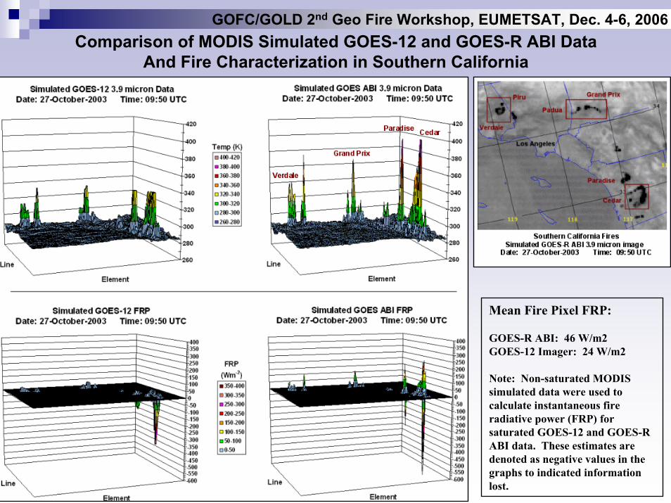
Comparison of MODIS Simulated GOES-12 and GOES-R ABI DataAnd Fire Characterization in Southern California
Mean Fire Pixel FRP:
GOES-R ABI: 46 W/m2GOES-12 Imager: 24 W/m2
Note: Non-saturated MODIS simulated data were used to calculate instantaneous fire radiative power (FRP) for saturated GOES-12 and GOES-R ABI data. These estimates are denoted as negative values in the graphs to indicated information lost.
GOFC/GOLD 2nd Geo Fire Workshop, EUMETSAT, Dec. 4-6, 2006
GOFC/GOLD 2nd Geo Fire Workshop, EUMETSAT, Dec. 4-6, 2006
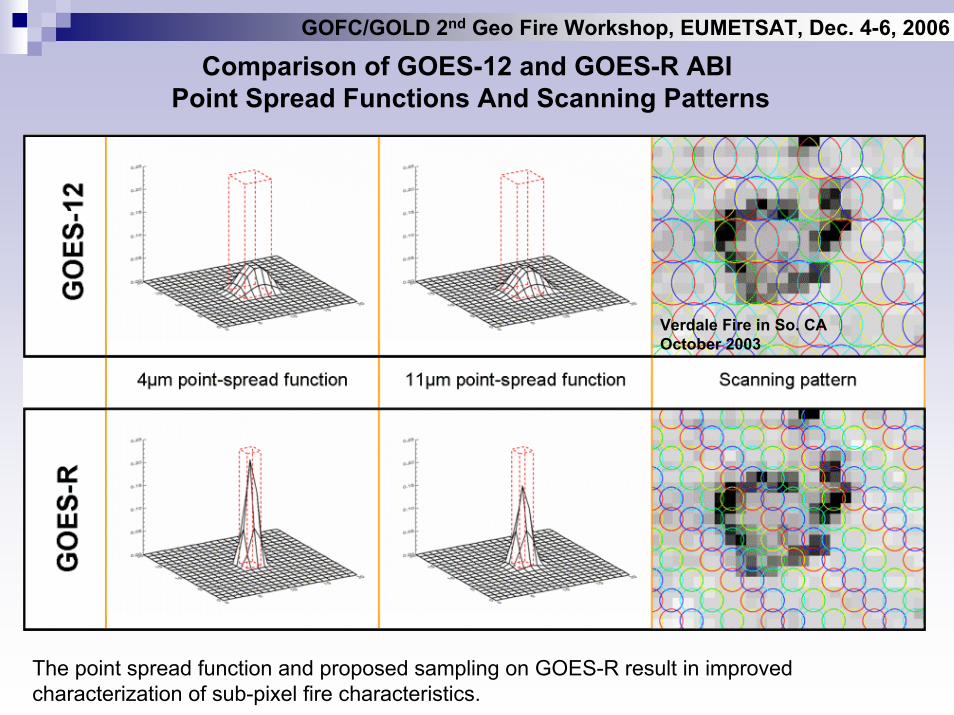
Comparison of GOES-12 and GOES-R ABI Point Spread Functions And Scanning Patterns
Verdale Fire in So. CAOctober 2003
The point spread function and proposed sampling on GOES-R result in improved characterization of sub-pixel fire characteristics.