Embed Size (px)
Citation preview
CONSERVATION COMMISSION OF WESTERN AUSTRALIA
STATUS PERFORMANCE ASSESSMENT: BIODIVERSITY CONSERVATION ON
WESTERN AUSTRALIAN ISLANDS
PHASE II – KIMBERLEY ISLANDS
FINAL REPORT

ii
CONTENTS
EXECUTIVE SUMMARY ............................................................................................................. 2 1. INTRODUCTION ................................................................................................................... 4
1.1 Background ....................................................................................................................... 4 1.2 Objectives .......................................................................................................................... 5 1.3 Methods ............................................................................................................................. 5
OBJECTIVES 1, 2 AND 3 .............................................................................................................. 5 2. KIMBERLEY ISLANDS ........................................................................................................ 5
2.1 Number and size distribution of Kimberley islands .......................................................... 5 2.2 Archipelagos and island groups ...................................................................................... 11 2.3 Assessment of knowledge and status of biodiversity conservation on Kimberley islands ............................................................................................................................................... 11
3. CONTEXT ............................................................................................................................ 12 3.1 Biodiversity values of Kimberley islands ....................................................................... 12 3.2 Threats to Kimberley island biodiversity ........................................................................ 16 3.3 Context – Findings ......................................................................................................... 19 3.4 Context – Recommendations ......................................................................................... 19
4. PLANNING .......................................................................................................................... 20 4.1 Kimberley islands vested in the Commission ................................................................. 20 4.2 Islands not vested in the Commission ............................................................................. 21 4.3 Progress relating to the recommendations in the document ‘Nature Conservation Reserves in the Kimberley Western Australia’ ..................................................................... 21 4.4 Inclusion of Kimberley islands in the State’s protected area system .............................. 23 4.5 Planning Findings ............................................................................................................ 27 4.6 Planning Recommendations ............................................................................................ 27
5. INPUTS ................................................................................................................................. 27 5.1 Inputs Findings ................................................................................................................ 28 5.2 Inputs Recommendations ................................................................................................ 28
6. MANAGEMENT SYSTEMS ............................................................................................... 28 6.1 Management System Findings ........................................................................................ 28 6.2 Management System Recommendations ........................................................................ 29
7. OUTPUTS ............................................................................................................................. 29 8. OUTCOMES ......................................................................................................................... 29
8.1 Outcomes Findings .......................................................................................................... 29 8.2 Outcomes Recommendations .......................................................................................... 29
OBJECTIVE 4 ............................................................................................................................... 30 9. CONSULTATION ................................................................................................................ 30
9.1 Mechanisms for Joint Management ................................................................................ 30 9.2 Kimberley Science and Conservation Strategy ............................................................... 30 9.3 Implementing recommendations ..................................................................................... 31
ACKNOWLEDGEMENTS ...................................................................................................... 32 BIBLIOGRAPHY ..................................................................................................................... 32 APPENDIX 1. Complete list of Kimberley islands .................................................................. 34 APPENDIX 2. Methods used in developing a list of Kimberley islands .................................. 89 APPENDIX 3. Archipelagos and major island groups in the Kimberley ................................. 91 APPENDIX 4. Kimberley islands annotated bibliography and notes on unpublished data ..... 94 APPENDIX 5. Kevin Coate’s Kimberley islands bird sightings from 1962 .......................... 100
APPENDIX 6. DEC’s response to report recommendations…………………………………123
iii
TABLES
1. Kimberley islands by size category ........................................................................................... 11 2. Priority flora records from Kimberley islands .......................................................................... 13 3. Listed threatened and priority fauna occurring on Kimberley islands ...................................... 14 4. Known turtle breeding rookeries on Kimberley islands ............................................................ 14 5. Known seabird breeding colonies on Kimberley islands .......................................................... 15 6. Status of reservation recommendations made in ‘Nature Conservation Reserves in the Kimberley Western Australia’ (1991) ................................................................................. 22 7. Kimberley islands of more than 200 ha, plus smaller islands with known biodiversity values ......................................................................................................................... 24
FIGURES
1. Trend in Annual Total Rainfall in Australia, 1950-2007 ........................................................... 18 2. Trend in Mean Temperature in Australia, 1950-2007 ................................................................ 18
MAPS 1. Kimberley coast showing archipelagos and location of detailed maps ........................................ 6 2. Buccaneer Archipelago and adjacent islands ............................................................................... 7 3. Islands in Doubtful Bay and in the southern Bonaparte Archipelago .......................................... 8 4. Islands in Admiralty Gulf, Vansittart Bay, Napier Broome Bay and adjacent areas ................... 9 5. Islands in Cambridge Gulf and adjacent areas ........................................................................... 10
April-2010 2
EXECUTIVE SUMMARY
The 2633 Kimberley islands comprise the least impacted part of one of the world’s last and largest tropical wilderness areas—the north Kimberley of Western Australia—and are attracting heightened world-wide interest and rapidly increasing tourism. Their varied, often spectacular, landscapes and ecosystems, which include sandstone and volcanic escarpments, rainforest patches, mangrove forests, freshwater creeks and swamps, savannah woodland and pristine beaches, harbour a wide variety of animals and plants, including some that occur nowhere else and some that are threatened with extinction on the mainland. South of the Kimberley, where most islands are conservation reserves vested in the Conservation Commission of Western Australia, inclusion of islands in the State’s protected area system has resulted in very effective biodiversity conservation outcomes. The Kimberley lies in stark contrast: of the 2633 Kimberley islands (53% of Western Australian islands of >1000 ha and 68% of WA islands of >20 ha), only 12 small islands are reserved for conservation and some of these do not have the highest level of protection. As is the case in the southern two thirds of the State, Kimberley islands are largely unaffected by the key threatened processes that are causing the decline of ecosystems and species on the Australian mainland; threats such as land clearing, introduced animals and plants, changed fire regimes, urban development and pollution. Islands in the Kimberley have high cultural and traditional values to local Aboriginal people and most are under Native Title claim. Future protection of the biodiversity of Kimberley islands must take account of the aspirations and rights of local Aboriginal people. Their future management offers employment opportunities for local people. The conservation of the biodiversity on Kimberley islands deserves a much higher priority by government than has been the case in the past. Kimberley islands collectively are an extremely valuable biodiversity conservation resource. There is an opportunity to include all or almost all Kimberley islands in the State’s protected area system using mechanisms such as conservation reserves that are jointly managed by the State and Traditional Owners. Knowledge of the terrestrial biodiversity of most Kimberley islands is generally very limited. While there have been biological surveys since the 1970s and there is good knowledge of the biodiversity of some islands, the high number of islands and the small number of surveys have combined to greatly limit the quantity of data. Most survey work has been on the larger islands and the Department of Environment and Conservation’s (DEC) current Kimberley islands Biological Survey is able to examine only 22 of the largest islands. Many of the smaller islands can be expected to have high biodiversity values as well. However, even with the limited quantity of data, it is clear that the larger Kimberley islands have very high biodiversity conservation values and that several smaller islands with seabird breeding colonies and marine turtle rookeries also require the highest levels of protection. This report includes a number of recommendations for future action. The lack of knowledge about the biodiversity of the vast majority of Kimberley islands indicates the need to extend the current Kimberley islands Biological Survey so that the biodiversity of many other larger Kimberley islands can be documented, plus that of a random sample of small islands. DEC’s Kimberley Region needs an identified island management budget so that staff can regularly visit
April-2010 3
and manage high priority islands. A regulated Kimberley islands and coast tourism and recreation management strategy that minimises impact on biodiversity and cultural values, developed in conjunction with the tourism industry and Traditional Owners, is urgently required. The few populations of feral animals, especially the Pacific rats on Adele Island, need to be eradicated. One weed, the stinking passionflower, is invading Kimberley islands and biological control research is urgent. Biosecurity is a vital requirement of island use to prevent further introductions of non-indigenous species and a biosecurity protocol, developed with the tourism industry, other industries in the region and local Aboriginal people, is needed. In coming decades, climate change appears to be a lower threat to Kimberley islands compared with those further south in WA; however, some islands will be impacted by rising sea levels and increased storm surge. Research into which islands and species will be impacted is needed, with strategies being developed to minimise impact. The Conservation Commission will seek ways to integrate the recommendations of this assessment report into the broader communication initiatives of the Kimberley Science and Conservation Strategy. Through this proposed integration the recommendations in this assessment report will provide part of the Conservation Commissions input into this strategy.
April-2010 4
1. INTRODUCTION
1.1 Background The Conservation Commission of Western Australia is a statutory body set up under the Conservation and Land Management Act 1984. Pursuant to section 19(1)(g) of the Act, the Commission has responsibility to assess and audit the performance of the Department of Environment and Conservation (DEC) and the Forest Products Commission in carrying out and complying with management plans. ‘Status Performance Assessments’ (SPA) are conducted with the agreement of DEC and focus on documenting the status of the biodiversity in a geographic area to provide an overall view of management performance. Performance assessments help inform the Conservation Commission's policy development function and its responsibility to advise the Minister on conservation and management of biodiversity components throughout the State. The assessments have a broad focus and are not confined to land vested in the Commission. In 2007, the Commission decided to conduct a SPA of biodiversity conservation on Western Australian islands. Phase I of the assessment covered islands vested in the Commission and was finalised in 2009. Phase II covers all Kimberley islands, most of which are not vested in the Commission. Of the 3747 islands, islets and rocks in Western Australia (WA) (Geoscience Australia http://www.ga.gov.au/education/geoscience-basics/landforms/islands.jsp), 2633 (70%) are located in the Kimberley. Of the 8222 islands in the whole of Australia, 32% are in the Kimberley. WA’s islands have very high biodiversity conservation values. They conserve unique subsets of Australia’s continental biodiversity, they harbour threatened species that have become extinct or have greatly declined on the mainland, they have genetically-unique populations of mainland species, they provide breeding sites unaffected by terrestrial predators (including exotic predators such as pigs, foxes, cats and rats) for sea turtles, seabirds, seals and sealions, and most are unaffected by most of the threatening processes causing decline of mainland biodiversity such as grazing, altered fire regimes, pests and diseases, urban development and pollution. The littoral zone of islands contains valuable biodiversity that needs protection in its own right and also provides energy and food for terrestrial organisms. Worldwide, islands are of two major types: oceanic (usually derived from mid-ocean volcanic or tectonic action) and continental (or landbridge) islands on continental shelves—sometimes these are called ‘offshore’ islands. None of the islands within the jurisdiction of the State of Western Australia are oceanic in origin. Most WA islands are continental in origin, having separated from the Australian mainland between 14,000 and 6,000 years before present as sea levels rose at the end of the last Pleistocene glaciation. Cays, accumulations of sand and/or coral rubble on reefs, usually have a more recent origin. The cays on Rowley Shoals and Scott Reef have accumulated on coral atolls. WA’s islands can be divided into two types:
• islands with mainly terrestrial values, containing unique ecosystems resulting from subsets of mainland ecosystems; many terrestrial-value islands are large enough to allow vegetation communities to grow away from the immediate influence of sea spray, and
• islands with mainly marine values (seabird breeding and resting, sea turtle breeding, seal and sealion breeding and haul-out sites); marine-value islands can be cays (sand and/or coral rubble) or small rocky islands and islets with or without beaches.
April-2010 5
On some islands both values are present, as turtles nest on large islands such as Bigge Island and seabirds will use many beaches and headlands on larger islands for resting.
1.2 Objectives Phase II of the islands SPA has four objectives: 1. Assessment of the existing data and status of biodiversity conservation on Kimberley
islands—incorporating the status of the progress relating to the recommendations in the document Nature Conservation Reserves in the Kimberley Western Australia (Burbidge et al., 1991);
2. Assessment of the key threatening processes to the Kimberley islands within the scope of this assessment including biosecurity, climate change, and development;
3. Evaluating and reporting on gaps and contribution of Kimberley islands to the island reserve system (with emphasis on comprehensiveness, adequacy and representativeness);
4. In consultation with Traditional Owners and stakeholders, recommending planning, research, management actions and reservation proposals for islands.
The results of the first three objectives are reported hereunder and have been utilised to progress objective 4.
1.3 Methods The Conservation Commission employed Dr Andrew Burbidge as the assessor in relation to objectives 1, 2 and 3. Information on the biodiversity of Kimberley islands was sought from the Department of Environment and Conservation, from the scientific literature and from naturalists and ecotourism tour guides. A list of Kimberley islands was developed as described in Appendix 2.
OBJECTIVES 1, 2 AND 3
2. KIMBERLEY ISLANDS This report is limited to the terrestrial biodiversity of Kimberley islands. The Phase I report drew attention to the values of the littoral (intertidal) biodiversity on islands and the importance of the seaward limit of Land Administration Act 1997 conservation reserves in the protection of littoral areas. Recommendations for marine reserves in the Kimberley were made in the Report of the Marine Parks and Reserves Selection Working Group, known as ‘The Wilson Report’ (MPRSWG 1994). The only marine park in the Kimberley surrounds Rowley Shoals.
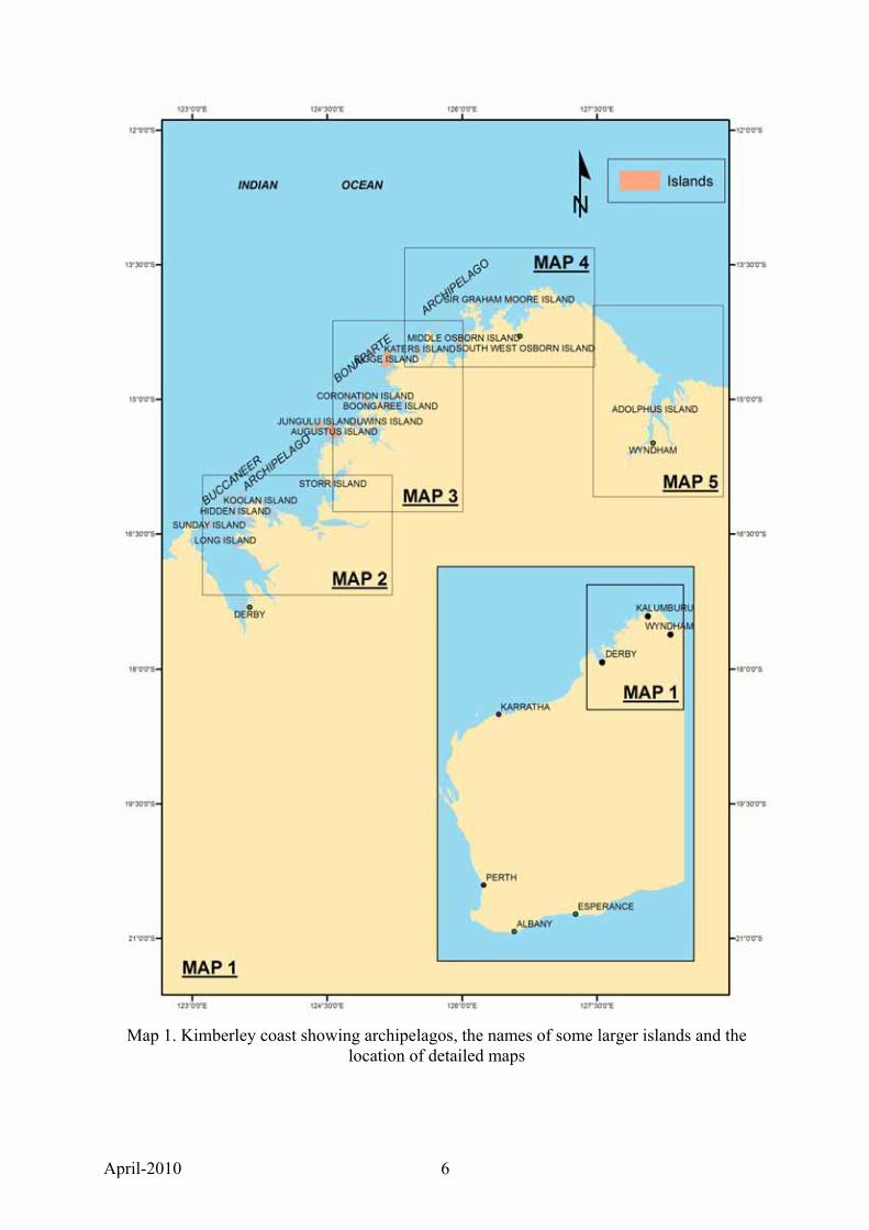
2.1 Number and size distribution of Kimberley islands No definitive list of Kimberley islands was available when this project commenced, nor was it clear where the boundaries of some archipelagos were situated. A list of islands was therefore developed. The methods used are described in Appendix 2. Table 1 shows the number of islands in different size categories. Maps 1, 2, 3, 4 and 5 (see over) depict the geographical location of the islands. There are approximately 200 islands ≥20 ha in the remainder of Western Australia, meaning that about 68% of Western Australian islands ≥20 ha are in the Kimberley. There are 18 islands ≥1000 ha in the remainder of the State; 53% of islands in this size category occur in the Kimberley.
April-2010 6
Map 1. Kimberley coast showing archipelagos, the names of some larger islands and the location of detailed maps
April-2010 7
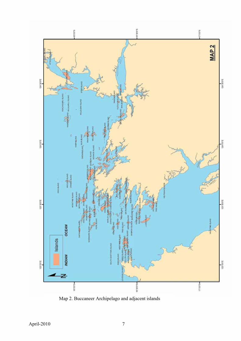
Map 2. Buccaneer Archipelago and adjacent islands
April-2010 8
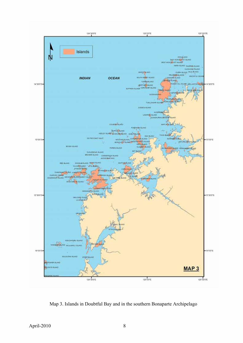
Map 3. Islands in Doubtful Bay and in the southern Bonaparte Archipelago
April-2010 9
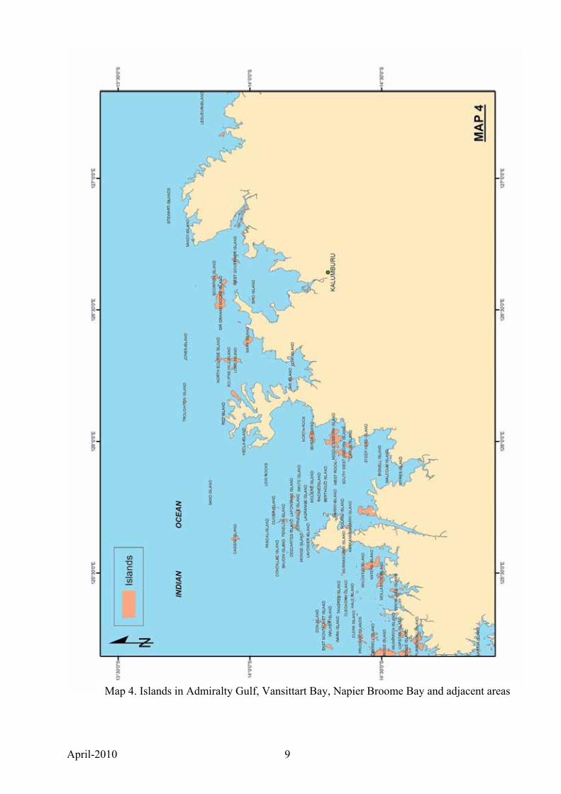
Map 4. Islands in Admiralty Gulf, Vansittart Bay, Napier Broome Bay and adjacent areas
April-2010 10
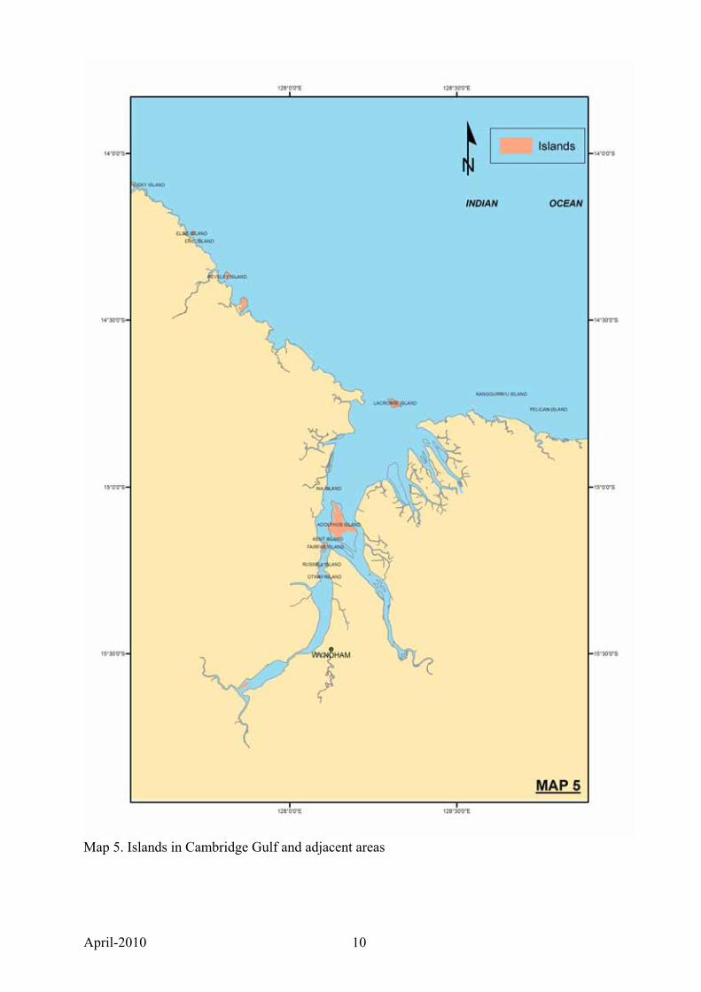
Map 5. Islands in Cambridge Gulf and adjacent areas
April-2010 11
Of the 2633 Kimberley islands, only 352 have been officially named, although some unnamed islands lie within named islands groups. There are 1000 named islands in the whole of Western Australia. Many Kimberley islands lie close to the coast and are separated from the mainland by narrow channels. Some are joined at low tide to the mainland by mangal and/or exposed mud, or by exposed reef. Islands ≥100 ha identified as being close to the coast by the ‘Ocean Mask’
GIS layer (see Appendix 2) were checked using satellite imagery and are shown as being connected at low tide (Y in column F in Appendix 1) or possibly connected (?Y). Islands <100 ha with a ‘1’ in column 2 (Ocean Mask) in Appendix 1 are likely to be joined to the mainland or an adjacent island at low tide. Of the total of 2633 Kimberley islands, 248 (9.4%) were identified as being likely to be joined to the mainland or an adjacent island at low tide.
2.2 Archipelagos and island groups Several major named archipelagos and many smaller island groups occur in the Kimberley. It is often unclear from maps where the boundaries to archipelagos and island groups lie. In some cases named island groups lie within archipelagos. To clarify boundaries, information was sought from Landgate and is summarised in Appendix 3.
2.3 Assessment of knowledge and status of biodiversity conservation on Kimberley islands Knowledge of the terrestrial biodiversity of most Kimberley islands is generally very limited. While there have been biological surveys since the 1970s, the large number of islands and the small number of surveys have combined to greatly limit the quantity of data. Most survey work, apart from some land snail collecting, has been on the larger islands and the current ‘Biological Survey of Kimberley islands’ is able to examine only 22 of the largest islands. Many of the smaller islands can be expected to have high biodiversity values as well. For example, How et al. (2006) located golden-backed tree-rat and pale field rat on an unnamed island of 14 ha in Scott Strait, a brief Kimberley Land Council Land and Sea Unit visit to Jar Island (150 ha) located echidna and golden-backed tree-rat (T. Vigilante1 pers. comm.) and the few small islands examined for land snails are rich in species, often currently not known from elsewhere. Knowledge of mammals, reptiles and frogs is available, in most cases, only from the larger islands. Knowledge of birds is more widespread resulting mainly from visits by ecotourism guides and naturalists (eg, Kevin Coate2, Appendix 6). Knowledge of seabird breeding islands is reasonably good, due to visits by scientists and naturalists. Knowledge of turtle breeding rookeries is poor. Casual observations suggest that almost every beach on Kimberley islands is used by turtles, mainly flatbacks Natator depressa and green turtles Chelonia mydas, for breeding, with a few islands, such as Browse Island, the Lacepede Islands, Slate Islands, Prudhoe Islands and Lesueur Island, known to have significant rookeries. Information provided by Kevin Coate on beaches that he has recorded as being used by turtles for breeding is included in Table 4).
1 Tom Vigilante, Kimberley Land Council, Loch St, Derby WA 6728 2 Kevin Coate, 11 Peak View, Canning Vale, WA 6155
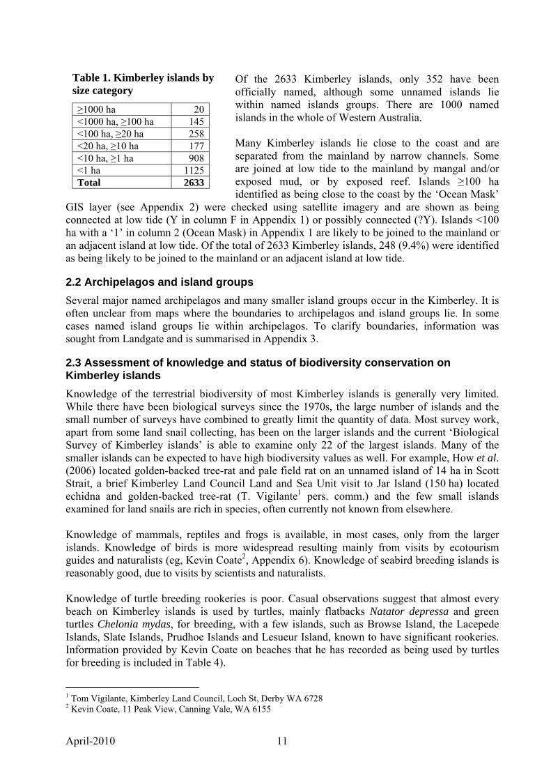
Table 1. Kimberley islands by size category
≥1000 ha 20 <1000 ha, ≥100 ha 145 <100 ha, ≥20 ha 258 <20 ha, ≥10 ha 177 <10 ha, ≥1 ha 908 <1 ha 1125 Total 2633
April-2010 12
3. CONTEXT
3.1 Biodiversity values of Kimberley islands
3.1.1 Overview In general, Kimberley islands have similar values to those of islands further south (see Phase I Report), but there are some differences. Kimberley islands are of very high biodiversity conservation value because:
• They protect unique ecosystems isolated for thousands of years. Each of the larger islands has a unique assemblage of plants and animals, a subset of the biota of the mainland from which they were isolated, reduced in variety dependent on the size of the island, the interactions between the species that were isolated, and chance. The more mobile species (eg, birds, plants with wind-blown, water-borne or bird-carried seeds) may establish and disappear from time to time (species turnover), but populations of many sedentary species have been restricted to an island since it was isolated from the mainland.
• Twenty-five ‘Priority Flora’ taxa are known from Kimberley islands (Table 2). • Six listed threatened fauna species and 13 Priority Fauna species are known from
Kimberley islands (Table 3). • No threatened ecological communities are known from Kimberley islands, but detailed
surveys have not been conducted. • Two vertebrates are known only from Kimberley islands: Buccaneer Burrowing Skink
Lerista praefrontalis from King Hall Island and Koolan Blind Snake Ramphotyphlops yampiensis from Koolan Island.
• No vertebrate subspecies have been described that are restricted to Kimberley islands, but it is likely that populations of many sedentary species on islands are genetically distinct from mainland populations.
• Several species of terrestrial molluscs are known only from Kimberley islands. • Australian islands are extremely important for mammal conservation and Kimberley
islands are no exception. Without islands, Australia’s appalling extinction record of 22 extinct species since European settlement would be even worse as eight species that became extinct on the mainland survive on islands. There have been no mammal extinctions in the North Kimberley IBRA Region (McKenzie et al. 2007), but some species still occurring there have suffered major declines in range and abundance. Several of these, such as the golden bandicoot Isoodon auratus and golden-backed tree-rat Mesembriomys macrurus, occur on islands. The Kimberley endemic mammals; monjon Petrogale burbidgei, scaly-tailed possum Wyulda squamicaudata and Kimberley rock-rat Zyzomys woodwardi all occur on islands. The golden-backed tree-rat is a ‘new endemic’ as it is considered to be extinct in the Northern Territory, the only other place it occurred.
• Fire regime change is of significant concern in the Kimberley with large areas now burning every year or almost every year. Most Kimberley islands burn infrequently and most fires on islands originate from lightning strikes. However, as visitation increases, so will fire incidence.
• Damage to vegetation and soils by feral herbivores such as cattle, pigs and donkeys is of significant concern in the Kimberley. Kimberley islands are free from these species.
• Most seabird breeding in WA occurs on islands, many species breed only on islands. WA now has the best (and expanding) populations of the island-nesting roseate tern Sterna dougallii anywhere is the world, including those on islands in the Kimberley. Three seabird species breed on Kimberley islands and do not breed further south in WA—great frigatebird Fregata minor, red-footed booby Sula sula and little tern Sterna albifrons—
April-2010 13
while three others breed mainly in the Kimberley with some breeding occurring also in the northern Pilbara, ie, masked booby Sula dactylatra, brown booby Sula leucogaster and lesser frigatebird Fregata ariel.
• In WA, most sea turtle breeding is on islands. Island rookeries, unlike those on mainland beaches, are not affected by egg predation from exotic predators. Kimberley islands have important rookeries of two species of turtle: green Chelonia mydas and flatback Natator depressus.
Often, particularly on the larger islands, some of the above features occur in combination: Bigge Island, for example, has threatened mammals and significant populations of reptiles and birds, as well as sea turtle rookeries.
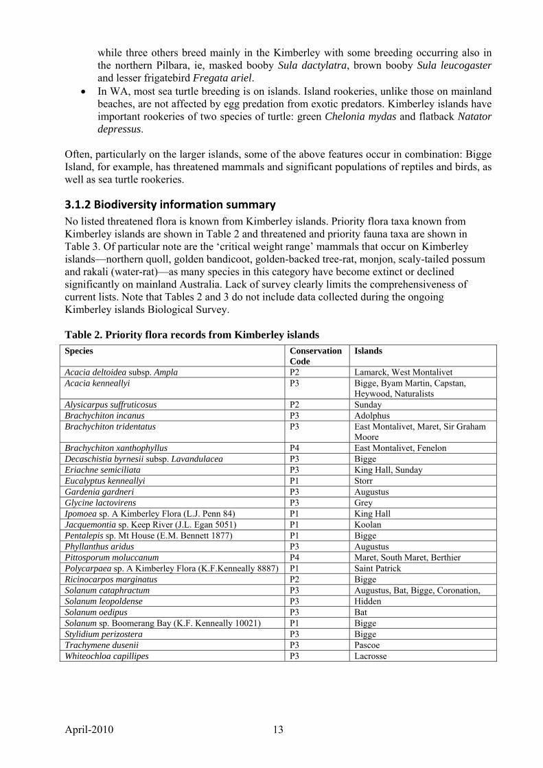
3.1.2 Biodiversity information summary No listed threatened flora is known from Kimberley islands. Priority flora taxa known from Kimberley islands are shown in Table 2 and threatened and priority fauna taxa are shown in Table 3. Of particular note are the ‘critical weight range’ mammals that occur on Kimberley islands—northern quoll, golden bandicoot, golden-backed tree-rat, monjon, scaly-tailed possum and rakali (water-rat)—as many species in this category have become extinct or declined significantly on mainland Australia. Lack of survey clearly limits the comprehensiveness of current lists. Note that Tables 2 and 3 do not include data collected during the ongoing Kimberley islands Biological Survey. Table 2. Priority flora records from Kimberley islands
Species Conservation Code
Islands
Acacia deltoidea subsp. Ampla P2 Lamarck, West Montalivet Acacia kenneallyi P3 Bigge, Byam Martin, Capstan,
Heywood, Naturalists Alysicarpus suffruticosus P2 Sunday Brachychiton incanus P3 Adolphus Brachychiton tridentatus P3 East Montalivet, Maret, Sir Graham
Moore Brachychiton xanthophyllus P4 East Montalivet, Fenelon Decaschistia byrnesii subsp. Lavandulacea P3 Bigge Eriachne semiciliata P3 King Hall, Sunday Eucalyptus kenneallyi P1 Storr Gardenia gardneri P3 Augustus Glycine lactovirens P3 Grey Ipomoea sp. A Kimberley Flora (L.J. Penn 84) P1 King Hall Jacquemontia sp. Keep River (J.L. Egan 5051) P1 Koolan Pentalepis sp. Mt House (E.M. Bennett 1877) P1 Bigge Phyllanthus aridus P3 Augustus Pittosporum moluccanum P4 Maret, South Maret, Berthier Polycarpaea sp. A Kimberley Flora (K.F.Kenneally 8887) P1 Saint Patrick Ricinocarpos marginatus P2 Bigge Solanum cataphractum P3 Augustus, Bat, Bigge, Coronation, Solanum leopoldense P3 Hidden Solanum oedipus P3 Bat Solanum sp. Boomerang Bay (K.F. Kenneally 10021) P1 Bigge Stylidium perizostera P3 Bigge Trachymene dusenii P3 Pascoe Whiteochloa capillipes P3 Lacrosse
April-2010 14
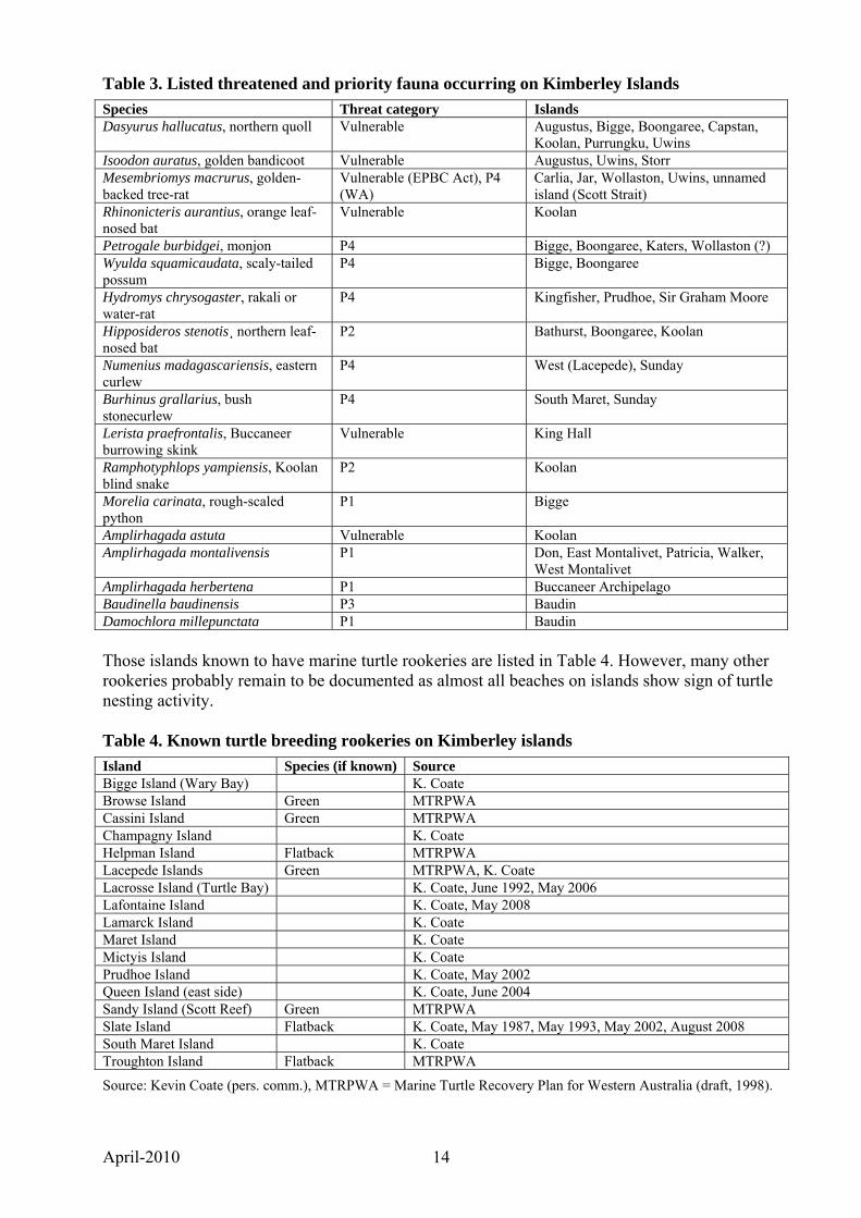
Table 3. Listed threatened and priority fauna occurring on Kimberley Islands
Species Threat category Islands Dasyurus hallucatus, northern quoll Vulnerable Augustus, Bigge, Boongaree, Capstan,
Koolan, Purrungku, Uwins Isoodon auratus, golden bandicoot Vulnerable Augustus, Uwins, Storr Mesembriomys macrurus, golden-backed tree-rat
Vulnerable (EPBC Act), P4 (WA)
Carlia, Jar, Wollaston, Uwins, unnamed island (Scott Strait)
Rhinonicteris aurantius, orange leaf-nosed bat
Vulnerable Koolan
Petrogale burbidgei, monjon P4 Bigge, Boongaree, Katers, Wollaston (?) Wyulda squamicaudata, scaly-tailed possum
P4 Bigge, Boongaree
Hydromys chrysogaster, rakali or water-rat
P4 Kingfisher, Prudhoe, Sir Graham Moore
Hipposideros stenotis¸ northern leaf-nosed bat
P2 Bathurst, Boongaree, Koolan
Numenius madagascariensis, eastern curlew
P4 West (Lacepede), Sunday
Burhinus grallarius, bush stonecurlew
P4 South Maret, Sunday
Lerista praefrontalis, Buccaneer burrowing skink
Vulnerable King Hall
Ramphotyphlops yampiensis, Koolan blind snake
P2 Koolan
Morelia carinata, rough-scaled python
P1 Bigge
Amplirhagada astuta Vulnerable Koolan Amplirhagada montalivensis P1 Don, East Montalivet, Patricia, Walker,
West Montalivet Amplirhagada herbertena P1 Buccaneer Archipelago Baudinella baudinensis P3 Baudin Damochlora millepunctata P1 Baudin Those islands known to have marine turtle rookeries are listed in Table 4. However, many other rookeries probably remain to be documented as almost all beaches on islands show sign of turtle nesting activity. Table 4. Known turtle breeding rookeries on Kimberley islands
Island Species (if known) Source Bigge Island (Wary Bay) K. Coate Browse Island Green MTRPWA Cassini Island Green MTRPWA Champagny Island K. Coate Helpman Island Flatback MTRPWA Lacepede Islands Green MTRPWA, K. Coate Lacrosse Island (Turtle Bay) K. Coate, June 1992, May 2006 Lafontaine Island K. Coate, May 2008 Lamarck Island K. Coate Maret Island K. Coate Mictyis Island K. Coate Prudhoe Island K. Coate, May 2002 Queen Island (east side) K. Coate, June 2004 Sandy Island (Scott Reef) Green MTRPWA Slate Island Flatback K. Coate, May 1987, May 1993, May 2002, August 2008 South Maret Island K. Coate Troughton Island Flatback MTRPWA
Source: Kevin Coate (pers. comm.), MTRPWA = Marine Turtle Recovery Plan for Western Australia (draft, 1998).
April-2010 15
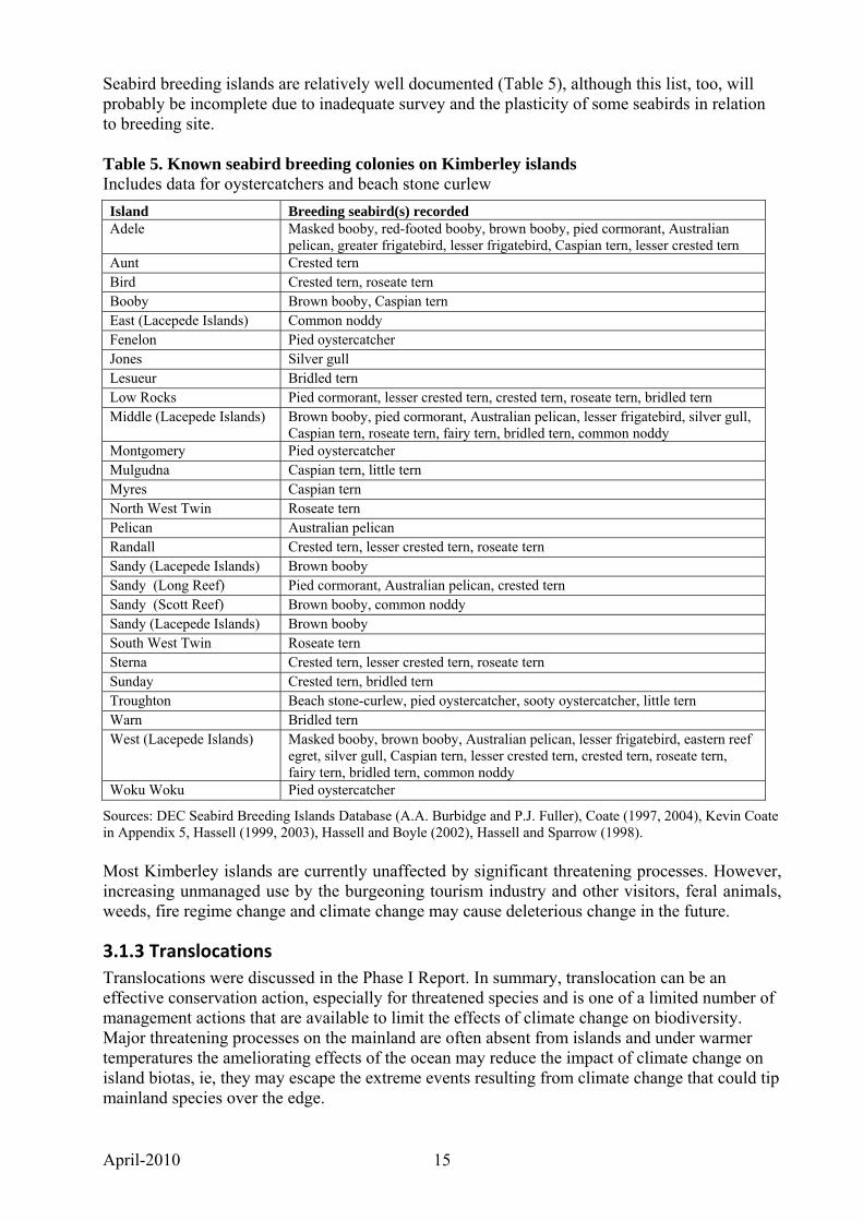
Seabird breeding islands are relatively well documented (Table 5), although this list, too, will probably be incomplete due to inadequate survey and the plasticity of some seabirds in relation to breeding site. Table 5. Known seabird breeding colonies on Kimberley islands Includes data for oystercatchers and beach stone curlew
Island Breeding seabird(s) recorded Adele Masked booby, red-footed booby, brown booby, pied cormorant, Australian
pelican, greater frigatebird, lesser frigatebird, Caspian tern, lesser crested tern Aunt Crested tern Bird Crested tern, roseate tern Booby Brown booby, Caspian tern East (Lacepede Islands) Common noddy Fenelon Pied oystercatcher Jones Silver gull Lesueur Bridled tern Low Rocks Pied cormorant, lesser crested tern, crested tern, roseate tern, bridled tern Middle (Lacepede Islands) Brown booby, pied cormorant, Australian pelican, lesser frigatebird, silver gull,
Caspian tern, roseate tern, fairy tern, bridled tern, common noddy Montgomery Pied oystercatcher Mulgudna Caspian tern, little tern Myres Caspian tern North West Twin Roseate tern Pelican Australian pelican Randall Crested tern, lesser crested tern, roseate tern Sandy (Lacepede Islands) Brown booby Sandy (Long Reef) Pied cormorant, Australian pelican, crested tern Sandy (Scott Reef) Brown booby, common noddy Sandy (Lacepede Islands) Brown booby South West Twin Roseate tern Sterna Crested tern, lesser crested tern, roseate tern Sunday Crested tern, bridled tern Troughton Beach stone-curlew, pied oystercatcher, sooty oystercatcher, little tern Warn Bridled tern West (Lacepede Islands) Masked booby, brown booby, Australian pelican, lesser frigatebird, eastern reef
egret, silver gull, Caspian tern, lesser crested tern, crested tern, roseate tern, fairy tern, bridled tern, common noddy
Woku Woku Pied oystercatcher
Sources: DEC Seabird Breeding Islands Database (A.A. Burbidge and P.J. Fuller), Coate (1997, 2004), Kevin Coate in Appendix 5, Hassell (1999, 2003), Hassell and Boyle (2002), Hassell and Sparrow (1998). Most Kimberley islands are currently unaffected by significant threatening processes. However, increasing unmanaged use by the burgeoning tourism industry and other visitors, feral animals, weeds, fire regime change and climate change may cause deleterious change in the future.
3.1.3 Translocations Translocations were discussed in the Phase I Report. In summary, translocation can be an effective conservation action, especially for threatened species and is one of a limited number of management actions that are available to limit the effects of climate change on biodiversity. Major threatening processes on the mainland are often absent from islands and under warmer temperatures the ameliorating effects of the ocean may reduce the impact of climate change on island biotas, ie, they may escape the extreme events resulting from climate change that could tip mainland species over the edge.
April-2010 16
Translocations of threatened animals to Kimberley islands are not warranted at present because:
• threatened Kimberley species, such as the northern quoll, golden bandicoot, golden-backed tree-rat and orange-leaf-nosed bat, and geographically restricted mammals such as monjon and scaly-tailed possum, occur naturally on islands,
• the lack of knowledge about the occurrence of many species on islands due to limited biological survey and a large number of islands means that there may be more occurrences of threatened species on islands, and
• introducing species to islands, even species native to the adjacent mainland, can lead to significant ecological change and is only warranted where the conservation outcomes outweigh the possible negative effects.
However, the status of some species on the Kimberley mainland is poorly known. Among mammals, for example, the taxonomic status of the Kimberley population of the brush-tailed phascogale (Phascogale tapoatafa) is unclear, but it may be a separate taxon or conservation management unit. The species has not been recorded from any island. Should it become clear that it is declining on the mainland, translocation to an island may be warranted.
3.2 Threats to Kimberley island biodiversity
3.2.1 Tourism and recreation The north Kimberley coast and islands are one of the world’s last large ‘wilderness’ areas and one that possesses spectacular scenery. As such the area is attracting increased tourism. Most tourism is from charter boats, with increasing numbers of larger vessels entering the industry, such as the 100-passenger ship ‘Orion’. Most trips include a visit to an Aboriginal site on Bigge Island. Aboriginal people are concerned about tourists visiting this site, which is a burial site as well as an art site. Naturalists Island in Prince Frederick Harbour is visited by ecotourism and naturalist groups and a beach there is also used by helicopters based at Mitchell Plateau to land to pick up people from vessels for sightseeing flights. Protection of islands and proper regulation of the industry, including meeting the aspirations and rights of Traditional Owners, are uregntly needed. Future management of Kimberley islands offers employment opportunities for local people. (Also see findings on tourism under the section titled management systems)
3.2 2 Feral animals Most Kimberley islands are free from feral animals, which is one of their biodiversity conservation values. The adjacent mainland is increasingly affected by feral cattle, donkeys, pigs and cats. Sir Graham Moore Island did have a population of feral pigs, but a recent visit during DEC’s Kimberley islands Biological Survey revealed that they had died out, apparently due to the island’s only fresh water source becoming saline after erosion caused by a cyclone. House mice (Mus musculus/domesticus) occur on Browse Island, black rats (Rattus rattus) occur on Sunday Island and Pacific rats (Rattus exulans) occur on Adele Island. According to the ShoreAir website www.shorebase.com.au/sa_troughton.html Troughton Island has introduced populations of quail and ‘Children’s pythons’. The cane toad (Bufo marinus) will establish in the eastern Kimberley in the near future and is likely to spread throughout the higher rainfall parts of the Kimberley. The arrival of cane toads into an area where they previously did not occur leads to a significant decline in some frog predators such as the northern quoll (Dasyurus hallucatus), although Queensland experience shows that these predators gradually increase in numbers in the presence of cane toads, perhaps not to the same level of abundance. Cane toads can be carried to islands when flooding occurs
April-2010 17
after high rainfall events, as has happened in the Sir Edward Pellew Islands in the Gulf of Carpentaria, Northern Territory. Predicting which islands might be invaded in the future is difficult, but islands near the mouth of major rivers would be most at risk. (Also see findings on feral animals under the section titled management systems)
3.2.3 Weeds One weed in particular, stinking passion flower Passiflora foetida, has established on several Kimberley islands. Its seeds are believed to be spread by birds. It is particularly common at the edges of rainforest patches and in swamps. Research into biological control is urgently needed.
3.2.4 Biosecurity Biosecurity issues for Western Australian islands were outlined in the Phase I Report. In summary, invasive exotic species have been the major cause of loss of biodiversity on Australian islands. Kimberley islands have, so far, largely escaped the establishment of invasive species. Black rats Rattus rattus established on the Lacepede Islands, probably from pearling vessels in the 19th Century and would have affected breeding success by smaller seabirds such as small terns. The rats were eradicated by the Department of Conservation and Land Management in 1986 (Burbidge and Morris 2002). Black rats occur on Sunday Island, possibly being transported in food and materials taken to the mission that once occurred there. The Pacific rat Rattus exulans occurs on Adele Island, presumably having escaped from an Indonesian fishing vessel. Pigs Sus scrofa occurred on Sir Graham Moore Island but are no longer present. The weed stinking passionflower Passiflora foetida occurs on several islands and is expanding in range. With visitation increasing, prevention of establishment of exotic animals and plants on Kimberley islands should have a very high priority, as should the eradication, where feasible, of any exotics detected on island conservation reserves. Currently, surveillance of islands aimed at detecting incursions of exotic animals or plants is ad hoc and should, for high priority islands at least, become a high priority regular action. Eradication expertise in the Department of Environment and Conservation needs to be maintained.
3.2.5 Fire regimes Fires in the Kimberley can start from lightning or be lit by humans. Most Kimberley islands burn infrequently, mainly from lightning strikes, but fires seem to be increasing in frequency on some visited islands, such as Augustus.
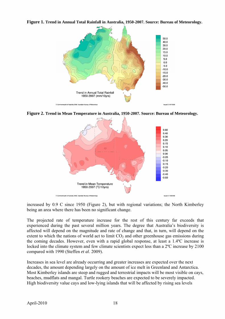
3.2.6 Climate change Significant changes in regional rainfall patterns have occurred over the past century (Figure 1), especially when comparing the period 1910-1950 and the period since. Since 1950, annual rainfall and extreme daily rainfall intensity and frequency have increased over the north west, mainly in the summer (Steffen et al. 2009). Australian average temperatures on land have
April-2010 18
Figure 1. Trend in Annual Total Rainfall in Australia, 1950-2007. Source: Bureau of Meteorology.
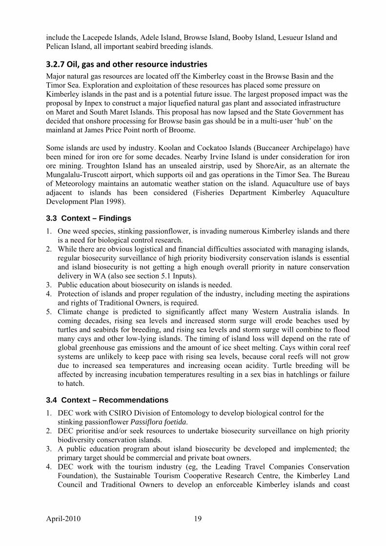
Figure 2. Trend in Mean Temperature in Australia, 1950-2007. Source: Bureau of Meteorology.
increased by 0.9 C since 1950 (Figure 2), but with regional variations; the North Kimberley being an area where there has been no significant change. The projected rate of temperature increase for the rest of this century far exceeds that experienced during the past several million years. The degree that Australia’s biodiversity is affected will depend on the magnitude and rate of change and that, in turn, will depend on the extent to which the nations of world act to limit CO2 and other greenhouse gas emissions during the coming decades. However, even with a rapid global response, at least a 1.4ºC increase is locked into the climate system and few climate scientists expect less than a 2ºC increase by 2100 compared with 1990 (Steffen et al. 2009). Increases in sea level are already occurring and greater increases are expected over the next decades, the amount depending largely on the amount of ice melt in Greenland and Antarctica. Most Kimberley islands are steep and rugged and terrestrial impacts will be most visible on cays, beaches, mudflats and mangal. Turtle rookery beaches are expected to be severely impacted. High biodiversity value cays and low-lying islands that will be affected by rising sea levels
April-2010 19
include the Lacepede Islands, Adele Island, Browse Island, Booby Island, Lesueur Island and Pelican Island, all important seabird breeding islands.
3.2.7 Oil, gas and other resource industries Major natural gas resources are located off the Kimberley coast in the Browse Basin and the Timor Sea. Exploration and exploitation of these resources has placed some pressure on Kimberley islands in the past and is a potential future issue. The largest proposed impact was the proposal by Inpex to construct a major liquefied natural gas plant and associated infrastructure on Maret and South Maret Islands. This proposal has now lapsed and the State Government has decided that onshore processing for Browse basin gas should be in a multi-user ‘hub’ on the mainland at James Price Point north of Broome. Some islands are used by industry. Koolan and Cockatoo Islands (Buccaneer Archipelago) have been mined for iron ore for some decades. Nearby Irvine Island is under consideration for iron ore mining. Troughton Island has an unsealed airstrip, used by ShoreAir, as an alternate the Mungalalu-Truscott airport, which supports oil and gas operations in the Timor Sea. The Bureau of Meteorology maintains an automatic weather station on the island. Aquaculture use of bays adjacent to islands has been considered (Fisheries Department Kimberley Aquaculture Development Plan 1998).
3.3 Context – Findings 1. One weed species, stinking passionflower, is invading numerous Kimberley islands and there
is a need for biological control research. 2. While there are obvious logistical and financial difficulties associated with managing islands,
regular biosecurity surveillance of high priority biodiversity conservation islands is essential and island biosecurity is not getting a high enough overall priority in nature conservation delivery in WA (also see section 5.1 Inputs).
3. Public education about biosecurity on islands is needed. 4. Protection of islands and proper regulation of the industry, including meeting the aspirations
and rights of Traditional Owners, is required. 5. Climate change is predicted to significantly affect many Western Australia islands. In
coming decades, rising sea levels and increased storm surge will erode beaches used by turtles and seabirds for breeding, and rising sea levels and storm surge will combine to flood many cays and other low-lying islands. The timing of island loss will depend on the rate of global greenhouse gas emissions and the amount of ice sheet melting. Cays within coral reef systems are unlikely to keep pace with rising sea levels, because coral reefs will not grow due to increased sea temperatures and increasing ocean acidity. Turtle breeding will be affected by increasing incubation temperatures resulting in a sex bias in hatchlings or failure to hatch.
3.4 Context – Recommendations 1. DEC work with CSIRO Division of Entomology to develop biological control for the
stinking passionflower Passiflora foetida. 2. DEC prioritise and/or seek resources to undertake biosecurity surveillance on high priority
biodiversity conservation islands. 3. A public education program about island biosecurity be developed and implemented; the
primary target should be commercial and private boat owners. 4. DEC work with the tourism industry (eg, the Leading Travel Companies Conservation
Foundation), the Sustainable Tourism Cooperative Research Centre, the Kimberley Land Council and Traditional Owners to develop an enforceable Kimberley islands and coast
April-2010 20
tourism and recreation management strategy that minimises impact on biodiversity and cultural values.
5. Research be conducted to identify Kimberley islands and species on islands that will be deleteriously affected by climate change, particularly islands with Kimberley endemics and islands with seabird and turtle breeding rookeries, and strategies be developed to minimise impact.
4. PLANNING
4.1 Kimberley islands vested in the Commission Information on the few Kimberley islands vested in the Conservation Commission was provided in the Phase I report and is provided in revised summary form below. Areas given below are from DEC’s tenure information system (TENIS) and from Appendix 1 (complete list of Kimberley islands), which were calculated from shape files (see Appendix 2 - Methods used in developing a list of Kimberley islands). There is notable variation in the areas figures listed below. Most of the area figures in Appendix 1 are considered more accurate than those listed in TENIS, with a few less accurate. A reconciliation of these vested island land area figures would be of benefit to future planning. Pelican Island (Joseph Bonaparte Gulf), 8.1 ha in TENIS, 19.4 ha in Appendix 1. Not Class A and does not extend to low water mark. Kevin Coate reported an abandoned Australian pelican rookery with about 30 nests, some containing up to three eggs, during a visit on 14 July 2005. Other birds present during this visit were Australian darter, eastern reef egret, striated heron, rufous night-heron, brahminy kite, Australian kestrel, eastern curlew, common greenshank, common sandpiper, grey-tailed tattler, ruddy turnstone, red-necked stint, beach stone-curlew, pied oystercatcher, sooty oystercatcher, red-capped plover, lesser sand plover, greater sand plover, gull-billed tern, crested tern, sacred kingfisher, willie wagtail and golden-headed cisticola. Lesueur Island (Joseph Bonaparte Gulf), 57.8 ha in TENIS, 72.0 ha in Appendix 1. Class A reserve, extends to low water mark. Lesueur is a sandy cay. Bridled tern breeding recorded in 1978 and 1982; no recent data. The island has a flatback turtle rookery. Low Rocks (Admiralty Gulf), 4 ha in TENIS, 5.1 ha in Appendix 1. Class A reserve, extends to high water mark only. Formerly a significant seabird breeding island, but recent information suggests that many species have moved to Sterna Island, on the west side of the Gulf, which is not reserved (Coate 2004). Kevin Coate (2005; Appendix 5) recorded breeding of pied cormorant, white-bellied sea-eagle, crested tern and lesser crested tern. Browse Island (Timor Sea), 14 ha in TENIS, 25.4 ha in Appendix 1. Not a Class A reserve; extends to low water mark. The site of a major turtle rookery. The island was extensively disturbed by guano mining more than 100 years ago and house mice occur there. A helipad is used by the oil and gas industry. It is visited by Indonesian fishers. Sandy Island, Scott Reef. Lies within a marine park, the total area of which is 11 568 ha (TENIS). It has a major turtle rookery, is used by the oil and gas industry and is visited by Indonesian fishers. Adele Island (Timor Sea, north of Buccaneer Archipelago), 217 ha in TENIS, 299.6 in Appendix 1. Class A reserve; extends to low water mark. A very significant seabird breeding island with several Japan-Australia Migratory Birds Agreement (JAMBA), China-Australia
April-2010 21
Migratory Birds Agreement (CAMBA) and Republic of Korea Migratory Birds Agreement (ROKAMBA) listed species breeding there. Of particular importance are large colonies of masked booby, brown booby, Australian pelican and lesser frigatebird. It has the only known WA colonies of red-footed booby and greater frigatebird. Intertidal zone used by migratory waders. The exotic Rattus exulans is present and a 2004 attempt by DEC’s West Kimberley District to eradicate it was not successful. Eradication should be a high priority, as the existence of this population increases the risk of animals being transported to other Kimberley islands or the mainland by boats. Planning is currently underway in DEC for another attempt to eradicate the rats. Swan Island (off Swan Point, near Cape Leveque), 29 ha in TENIS, 22.0 ha in Appendix 1. Not a Class A reserve; extends to high water mark only. Swan Island was reserved at a time when brown boobies nested there, but there is nothing to indicate that they still do and there is no other information about its biodiversity values. Lacepede Islands (north of Broome), four islands totalling 180.2 ha in TENIS, Appendix 1: West Island 90.6 ha, Middle Island 60.9 ha, Sandy Island 7.94 ha, East Island 3.5 ha, Total 162.9 ha. Not a Class A reserve; extends to low water mark. Very important seabird and green turtle breeding islands. Major seabird breeding colonies of masked booby, brown booby, pied cormorant, Australian pelican and lesser frigatebird. Black Rats have been eradicated. Visited by tourist charter boats. Bedwell and Cunningham Islands (Rowley Shoals). No area in TENIS, 56.3 ha and 63.5 ha in Appendix 1. Located within a marine park. Red-tailed tropicbirds breed on Bedwell Island, but it is a minor breeding site for the species, which has large breeding colonies on several oceanic islands. No available information on Cunningham Island. The Rowley Shoals Marine Park Management Plan covers the surrounding waters. No management plans exist for any of the reserved Kimberley islands.
4.2 Islands not vested in the Commission The great majority of Kimberley islands are unallocated Crown land. DEC does have certain responsibilities on islands which are unallocated Crown land or unmanaged reserves such as managing declared plants and animals. A number of islands near the former Kunmunya Mission are included in Reserve 23079 for ‘Use and Benefit of Aborigines’, which is vested in the Aboriginal Lands Trust. It includes islands in Doubtful Bay and the Montgomery Islands, north to Cape Wellington. Larger islands within this reserve include Augustus, Byam Martin, Champagny, Heywood, Jungulu, Uwins, St Andrew and St Patrick. Other reserves for ‘Use and Benefit of Aborigines’ that include islands are reserves 23080 (Storr Island and islands in Doubtful Bay), 23081 (unnamed islands north east of Augustus Island and near Lizard Island), 24705 (unnamed island east of Cape Bougainville), 25106 (Sunday and Hancock Islands), 25107 (East Sunday) and 29174 (Jackson Island). Available published and unpublished terrestrial biodiversity information is summarised in the Annotated Bibliography (Appendix 4).
4.3 Progress relating to the recommendations in the document ‘Nature Conservation Reserves in the Kimberley Western Australia’ Nature Conservation Reserves in the Kimberley Western Australia (Burbidge et al. 1991) was the submission by the former Department of Conservation and Land Management to the
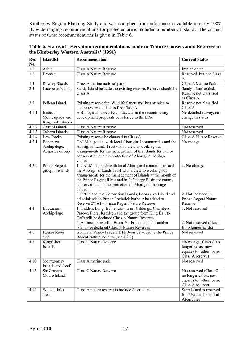
April-2010 22
Kimberley Region Planning Study and was complied from information available in early 1987. Its wide-ranging recommendations for protected areas included a number of islands. The current status of these recommendations is given in Table 6. Table 6. Status of reservation recommendations made in ‘Nature Conservation Reserves in the Kimberley Western Australia’ (1991)
Rec No.
Island(s) Recommendation Current Status
1.1 Adele Class A Nature Reserve Implemented 1.2 Browse Class A Nature Reserve Reserved, but not Class
A 1.3 Rowley Shoals Class A marine national parks Class A Marine Park 2.4 Lacepede Islands Sandy Island be added to existing reserve. Reserve should be
Class A. Sandy Island added. Reserve not classified as Class A.
3.7 Pelican Island Existing reserve for ‘Wildlife Sanctuary’ be amended to nature reserve and classified Class A
Reserve not classified Class A
4.1.1 Institut, Montesquieu and Kingsmill Islands
A Biological survey be conducted; in the meantime any development proposals be referred to the EPA
No detailed survey, no change in status
4.1.2 Cassini Island Class A Nature Reserve Not reserved 4.1.3 Osborn Islands Class A Nature Reserve Not reserved 4.1.4 Low Rocks Existing reserve be changed to Class A Class A Nature Reserve 4.2.1 Bonaparte
Archipelago, Augustus Group
CALM negotiate with local Aboriginal communities and the Aboriginal Lands Trust with a view to working out arrangements for the management of the islands for nature conservation and the protection of Aboriginal heritage values
No change
4.2.2 Prince Regent group of islands
1. CALM negotiate with local Aboriginal communities and the Aboriginal Lands Trust with a view to working out arrangements for the management of islands at the mouth of the Prince Regent River and in St George Basin for nature conservation and the protection of Aboriginal heritage values 2. Bat Island, the Coronation Islands, Boongaree Island and other islands in Prince Frederick harbour be added to Reserve 27164 – Prince Regent Nature Reserve
1. No change 2. Not included in Prince Regent Nature Reserve
4.3 Buccaneer Archipelago
1. Hidden, Long, Irvine, Conilurus, Gibbings, Chambers, Pascoe, Flora, Kathleen and the group from King Hall to Caffarelli be declared Class A Nature Reserves 2. Admiral, Powerful, Bruin, Sir Frederick and Lachlan Islands be declared Class B Nature Reserves
1. Not reserved 2. Not reserved (Class B no longer exists)
4.6 Hunter River area
Islands in Prince Frederick Harbour be added to the Prince Regent Nature Reserve (see 4.2.2)
Not reserved
4.7 Kingfisher Islands
Class C Nature Reserve No change (Class C no longer exists, now equates to ‘other’ or not Class A reserve)
4.10 Montgomery Islands and Reef
Class A marine park Not reserved
4.13 Sir Graham Moore Islands
Class C Nature Reserve Not reserved (Class C no longer exists, now equates to ‘other’ or not Class A reserve)
4.14 Walcott Inlet area.
Class A nature reserve to include Storr Island Storr Island is reserved for ‘Use and benefit of Aborigines’
April-2010 23
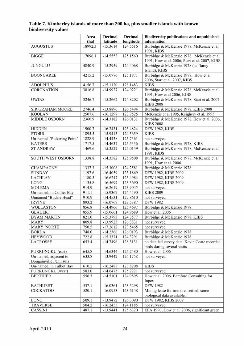
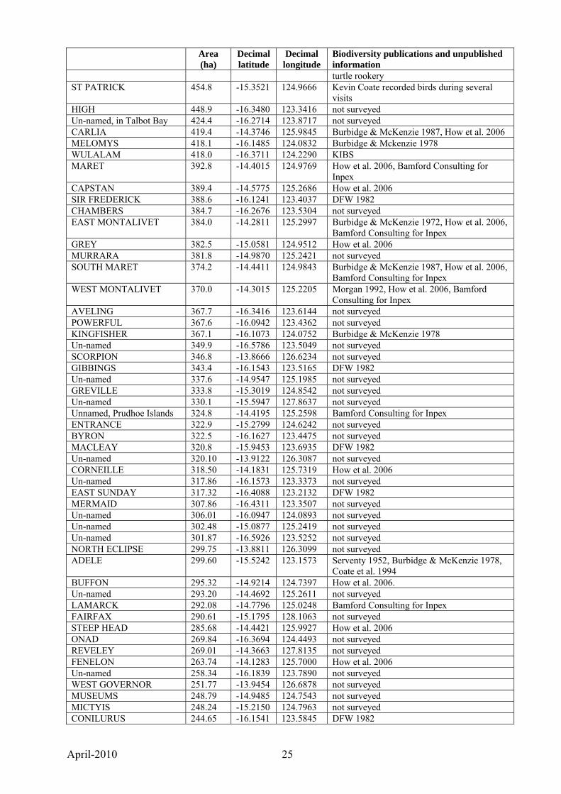
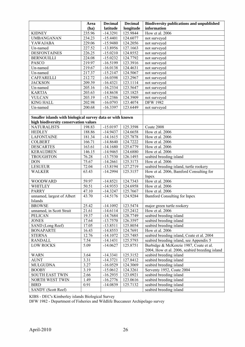
4.4 Inclusion of Kimberley islands in the State’s protected area system Very few Kimberley islands are included in Western Australia’s system of protected areas and the reserves system in the Kimberley as a whole, and for Kimberley islands in particular, does not meet accepted ‘Comprehensive, Adequate and Representative’ criteria. Only 12 of the 2633 Kimberley islands are currently reserved for nature conservation. Some of these do not have the highest level of protection and some do not extend to low water mark. Almost all recommendations for additional nature conservation reserves made in the past have not been enacted, initially because of concerns expressed to government by resource industries and the State Department of Mines and Petroleum (and its predecessors) that this would inhibit mineral exploration and production, and more recently also because of Native Title issues. Future protection of the biodiversity of Kimberley islands must take account of the aspirations and native title claims of local Aboriginal people. Establishing priorities for inclusion of Kimberley islands in a protected area system is greatly inhibited by lack of comprehensive biodiversity information. Because there are more than two thousand islands that have not had their biodiversity documented, it will not be possible to document the distribution of plants and animals on all but a few of them in the foreseeable future. Detailed information will continue to be limited to a few large islands and the biodiversity of smaller islands will, unless considerable resources are allocated to biological survey in the near future, remain largely unknown. However, available information demonstrates that the larger Kimberley islands that have been examined by biologists have very high biodiversity conservation values. The 109 Kimberley islands of more than 200 ha, plus smaller islands with biodiversity data and/or known high conservation values, together with a brief notes on their biodiversity values where known, are listed in Table 7 (see over). Of the 109 islands of >200 ha, 50 are noted as ‘not surveyed’.
April-2010 24
Table 7. Kimberley islands of more than 200 ha, plus smaller islands with known biodiversity values
Area (ha)
Decimal latitude
Decimal longitude
Biodiversity publications and unpublished information
AUGUSTUS 18992.3 -15.3614 124.5516 Burbidge & McKenzie 1978, McKenzie et al. 1991, KIBS
BIGGE 17096.1 -14.5553 125.1560 Burbidge & McKenzie 1978, McKenzie et al. 1991, How et al. 2006, Start et al. 2007, KIBS
JUNGULU 4840.9 -15.2959 124.4068 Burbidge & McKenzie 1978 (as Darcy Island), KIBS
BOONGAREE 4215.2 -15.0776 125.1871 Burbidge & McKenzie 1978, How et al. 2006, Start et al. 2007, KIBS
ADOLPHUS 4156.7 -15.1120 128.1483 KIBS CORONATION 3816.8 -14.9927 124.9221 Burbidge & McKenzie 1978, McKenzie et al.
1991, How et al 2006, KIBS UWINS 3246.7 -15.2662 124.8202 Burbidge & McKenzie 1978, Start et al. 2007,
KIBS 2008 SIR GRAHAM MOORE 2746.4 -13.8896 126.5494 Burbidge & McKenzie 1978, KIBS 2008 KOOLAN 2507.6 -16.1297 123.7525 McKenzie et al 1995, Keighery et al. 1995 MIDDLE OSBORN 2360.9 -14.3182 126.0131 Burbidge & McKenzie 1978, How et al. 2006,
KIBS 2008 HIDDEN 1900.7 -16.2431 123.4824 DFW 1982, KIBS STORR 1895.5 -15.9413 124.5659 KIBS Un-named "Pickering Point" 1828.9 -14.4438 125.7361 not surveyed KATERS 1717.5 -14.4637 125.5336 Burbidge & McKenzie 1978, KIBS ST ANDREW 1469.6 -15.3522 125.0139 Burbidge & McKenzie 1978, McKenzie et al.
1991, KIBS SOUTH WEST OSBORN 1338.8 -14.3582 125.9508 Burbidge & McKenzie 1978, McKenzie et al.
1991, How et al. 2006 CHAMPAGNY 1337.3 -15.3008 124.2581 Burbidge & McKenzie 1978 SUNDAY 1197.6 -16.4059 123.1869 DFW 1982, KIBS 2009 LACHLAN 1180.5 -16.6247 123.4984 DFW 1982, KIBS 2009 LONG 1135.8 -16.5697 123.3690 DFW 1982, KIBS 2009 MOLEMA 914.9 -16.2619 123.9045 not surveyed Un-named, in Collier Bay 911.1 -15.9367 124.4590 KIBS 2009 Unnamed "Buckle Head" 910.9 -14.4531 127.8610 not surveyed IRVINE 893.2 -16.0767 123.5387 DFW 1982 WOLLASTON 856.8 -14.4966 125.4697 Burbidge & McKenzie 1978 GLAUERT 855.9 -15.0661 124.9689 How et al. 2006 BYAM MARTIN 821.0 -15.3793 124.3577 Burbidge & McKenzie 1978, KIBS MARY 809.8 -13.9923 126.3831 not surveyed MARY NORTH 750.5 -17.2612 123.5465 not surveyed BORDA 748.0 -14.2366 126.0193 Burbidge & McKenzie 1978 HEYWOOD 722.8 -15.3371 124.3291 Burbidge & McKenzie 1978 LACROSSE 653.4 -14.7496 128.3131 no detailed survey data, Kevin Coate recorded
birds during several visits PURRUNGKU (east) 645.8 -14.6344 125.2480 How et al. 2006 Un-named, adjacent to Bougainville Peninsula
633.8 -13.9442 126.1758 not surveyed
Un-named, in Talbot Bay 610.2 -16.2488 123.8208 KIBS PURRUNGKU (west) 583.0 -14.6475 125.2221 not surveyed BERTHIER 556.3 -14.5101 124.9895 How et al. 2006. Bamford Consulting for
Inpex BATHURST 537.1 -16.0361 123.5298 DFW 1982 COCKATOO 520.1 -16.0953 123.6148 Mining lease for iron ore, settled, some
biological data available. LONG 509.1 -13.9472 126.3090 DFW 1982, KIBS 2009 TRAVERSE 504.2 -16.2455 124.1185 not surveyed CASSINI 487.1 -13.9441 125.6320 EPA 1990, How et al. 2006, significant green
April-2010 25
Area (ha)
Decimal latitude
Decimal longitude
Biodiversity publications and unpublished information turtle rookery
ST PATRICK 454.8 -15.3521 124.9666 Kevin Coate recorded birds during several visits
HIGH 448.9 -16.3480 123.3416 not surveyed Un-named, in Talbot Bay 424.4 -16.2714 123.8717 not surveyed CARLIA 419.4 -14.3746 125.9845 Burbidge & McKenzie 1987, How et al. 2006 MELOMYS 418.1 -16.1485 124.0832 Burbidge & Mckenzie 1978 WULALAM 418.0 -16.3711 124.2290 KIBS MARET 392.8 -14.4015 124.9769 How et al. 2006, Bamford Consulting for
Inpex CAPSTAN 389.4 -14.5775 125.2686 How et al. 2006 SIR FREDERICK 388.6 -16.1241 123.4037 DFW 1982 CHAMBERS 384.7 -16.2676 123.5304 not surveyed EAST MONTALIVET 384.0 -14.2811 125.2997 Burbidge & McKenzie 1972, How et al. 2006,
Bamford Consulting for Inpex GREY 382.5 -15.0581 124.9512 How et al. 2006 MURRARA 381.8 -14.9870 125.2421 not surveyed SOUTH MARET 374.2 -14.4411 124.9843 Burbidge & McKenzie 1987, How et al. 2006,
Bamford Consulting for Inpex WEST MONTALIVET 370.0 -14.3015 125.2205 Morgan 1992, How et al. 2006, Bamford
Consulting for Inpex AVELING 367.7 -16.3416 123.6144 not surveyed POWERFUL 367.6 -16.0942 123.4362 not surveyed KINGFISHER 367.1 -16.1073 124.0752 Burbidge & McKenzie 1978 Un-named 349.9 -16.5786 123.5049 not surveyed SCORPION 346.8 -13.8666 126.6234 not surveyed GIBBINGS 343.4 -16.1543 123.5165 DFW 1982 Un-named 337.6 -14.9547 125.1985 not surveyed GREVILLE 333.8 -15.3019 124.8542 not surveyed Un-named 330.1 -15.5947 127.8637 not surveyed Unnamed, Prudhoe Islands 324.8 -14.4195 125.2598 Bamford Consulting for Inpex ENTRANCE 322.9 -15.2799 124.6242 not surveyed BYRON 322.5 -16.1627 123.4475 not surveyed MACLEAY 320.8 -15.9453 123.6935 DFW 1982 Un-named 320.10 -13.9122 126.3087 not surveyed CORNEILLE 318.50 -14.1831 125.7319 How et al. 2006 Un-named 317.86 -16.1573 123.3373 not surveyed EAST SUNDAY 317.32 -16.4088 123.2132 DFW 1982 MERMAID 307.86 -16.4311 123.3507 not surveyed Un-named 306.01 -16.0947 124.0893 not surveyed Un-named 302.48 -15.0877 125.2419 not surveyed Un-named 301.87 -16.5926 123.5252 not surveyed NORTH ECLIPSE 299.75 -13.8811 126.3099 not surveyed ADELE 299.60 -15.5242 123.1573 Serventy 1952, Burbidge & McKenzie 1978,
Coate et al. 1994 BUFFON 295.32 -14.9214 124.7397 How et al. 2006. Un-named 293.20 -14.4692 125.2611 not surveyed LAMARCK 292.08 -14.7796 125.0248 Bamford Consulting for Inpex FAIRFAX 290.61 -15.1795 128.1063 not surveyed STEEP HEAD 285.68 -14.4421 125.9927 How et al. 2006 ONAD 269.84 -16.3694 124.4493 not surveyed REVELEY 269.01 -14.3663 127.8135 not surveyed FENELON 263.74 -14.1283 125.7000 How et al. 2006 Un-named 258.34 -16.1839 123.7890 not surveyed WEST GOVERNOR 251.77 -13.9454 126.6878 not surveyed MUSEUMS 248.79 -14.9485 124.7543 not surveyed MICTYIS 248.24 -15.2150 124.7963 not surveyed CONILURUS 244.65 -16.1541 123.5845 DFW 1982
April-2010 26
Area (ha)
Decimal latitude
Decimal longitude
Biodiversity publications and unpublished information
KIDNEY 235.96 -14.3291 125.9844 How et al. 2006 UMBANGANAN 234.23 -15.4401 124.6077 not surveyed YAWAJABA 229.06 -15.9480 124.2056 not surveyed Un-named 227.52 -13.8956 127.1663 not surveyed DESFONTAINES 226.25 -15.0210 124.8552 not surveyed BERNOUILLI 224.08 -15.0232 124.7792 not surveyed PASCO 219.97 -16.5199 123.3916 not surveyed Un-named 219.67 -16.0138 124.4631 not surveyed Un-named 217.37 -15.2147 124.5067 not surveyed CAFFARELLI 212.72 -16.0398 123.2967 not surveyed JACKSON 209.39 -16.4321 123.1114 not surveyed Un-named 205.16 -16.2334 123.5647 not surveyed KARTJA 203.63 -14.8638 125.1825 not surveyed VULCAN 203.19 -15.2386 124.3909 not surveyed KING HALL 202.98 -16.0793 123.4074 DFW 1982 Un-named 200.68 -16.3397 123.6449 not surveyed Smaller islands with biological survey data or with known high biodiversity conservation values
NATURALISTS 198.83 -15.0197 125.3598 Coate 2008 HEDLEY 188.86 -14.9437 124.6658 How et al. 2006 LAFONTAINE 181.34 -14.1615 125.7878 How et al. 2006 COLBERT 166.71 -14.8640 124.7222 How et al. 2006 DESCARTES 163.61 -14.1680 125.6779 How et al. 2006 KERAUDREN 146.15 -14.9465 124.6880 How et al. 2006 TROUGHTON 76.28 -13.7530 126.1493 seabird breeding island DON 75.67 -14.2661 125.3173 How et al. 2006 LESUEUR 72.04 -13.8194 127.2719 seabird breeding island, turtle rookery WALKER 63.43 -14.2994 125.3157 How et al. 2006, Bamford Consulting for
Inpex WOODWARD 59.97 -14.8521 124.7343 How et al. 2006 WHITLEY 50.51 -14.9353 124.6958 How et al. 2006 PARRY 47.10 -14.3247 125.7667 How et al. 2006 unnamed, largest of Albert Islands
43.70 -14.5176 124.9284 Bamford Consulting for Inpex
BROWSE 25.42 -14.1092 123.5474 major green turtle rookery unnamed, in Scott Strait 21.61 -14.6114 125.2412 How et al. 2006 PELICAN 19.37 -14.7684 128.7749 seabird breeding island JONES 17.64 -13.7570 126.3597 seabird breeding island SAND (Long Reef) 17.05 -13.8511 125.8054 seabird breeding island BONAPARTE 16.43 -14.8553 124.7691 How et al. 2006 STERNA 12.76 -14.1072 125.7485 seabird breeding island, Coate et al. 2004 RANDALL 7.54 -14.1431 125.5793 seabird breeding island, see Appendix 5 LOW ROCKS 5.09 -14.0627 125.8751 Burbidge & McKenzie 1987, Coate et al.
2004, How et al. 2006, seabird breeding island WARN 3.64 -14.3341 125.3152 seabird breeding island AUNT 3.31 -14.3721 127.8412 seabird breeding island MULGUDNA 3.27 -16.0529 124.3069 seabird breeding island BOOBY 3.19 -15.0612 124.3261 Serventy 1952, Coate 2004 SOUTH EAST TWIN 2.66 -16.2935 123.0921 seabird breeding island NORTH WEST TWIN 1.49 -16.2776 123.0616 seabird breeding island BIRD 0.91 -14.0839 125.7132 seabird breeding island SANDY (Scott Reef) seabird breeding island
KIBS - DEC's Kimberley islands Biological Survey DFW 1982 - Department of Fisheries and Wildlife Buccaneer Archipelago survey
April-2010 27
Making specific recommendations for particular islands or island groups to be included in the protected area system would be biased in favour of those for which information is available. It is clear, however, that all the larger islands have significant biodiversity conservation values and that some smaller islands with seabird colonies and/or marine turtle rookeries also require urgent protection. Kimberley islands collectively are an extremely valuable biodiversity conservation resource. There is an opportunity to include all or almost all Kimberley islands in the State’s protected area system using mechanisms such as conservation reserves that are jointly managed by the State and Traditional Owners.
4.5 Planning Findings 1. Very few Kimberley islands (12 out of 2633) are included in the State’s system of protected
areas. 2. No management plans exist for any of the reserved Kimberley islands. 3. Almost all recommendations for additional nature conservation reserves made in the past,
including those in Nature Conservation Reserves in the Kimberley Western Australia (Burbidge et al. 1991), have not been enacted.
4. Detailed biodiversity information is limited to the largest islands and a few smaller islands known to have seabird breeding colonies and/or marine turtle rookeries.
5. Larger islands that have been surveyed by biologists are known to have very high biodiversity conservation values.
6. The 2633 Kimberley islands collectively are a very significant biodiversity conservation asset.
7. Translocation of threatened species to Kimberley islands is currently not warranted.
4.6 Planning Recommendations 1. The Conservation Commission and DEC work towards including all Kimberley islands in the
State’s protected area system in a manner that takes account of the rights and aspirations of Traditional Owners. This can be considered as an important recommendation with a medium to long term view. For immediate consideration the list of outstanding recommendations presented in Table 6 (Status of reservation recommendations made in ‘Nature Conservation Reserves in the Kimberley Western Australia’ – 1991) and Table 7 (Kimberly islands of more than 200 ha, plus smaller islands with known biodiversity values) should form the priority listing for this recommendation.
5. INPUTS Scientific research has been limited to occasional biological survey, mainly of the larger islands, with the current Kimberley islands Biological Survey, which ends in 2010, being a significant investment. Allocation of resources by DEC to Kimberley island survey, research and management is minimal. Biological survey data has also been collected by the Western Australian Museum, by Western Australian Naturalists’ Club expeditions, by Landscope Expeditions and by ecotourism tour guides. DEC’s Kimberley region staff do not have an identified budget for managing islands and do not visit any Kimberley islands on a routine basis. Island biodiversity is clearly a very important component of WA’s biodiversity, and island conservation and management has been recognised as a significant activity for many decades. Nevertheless, resource allocation to Kimberley island conservation and management is very low. While there are obvious logistical and financial difficulties associated with managing islands there seems to be no specific allocation of resources to island conservation.
April-2010 28
5.1 Inputs Findings 1. DECs Kimberley Region does not have an identified budget for work on islands. 2. Apart from an attempt to eradicate Rattus exulans from Adele Island, DEC’s Kimberley
Region staff have not undertaken any work on Kimberley islands. 3. While there have been occasional biodiversity surveys by DEC and its predecessors and by
the Western Australian Museum, there is no ongoing program to accumulate biodiversity data for Kimberley islands.
4. DEC’s Science Division is currently undertaking a major biological survey of 22 the largest Kimberley islands, which will provide high quality data for them, in many cases augmenting data collected previously. There are no plans to survey the thousands of other Kimberley islands.
5.2 Inputs Recommendations 1. Kimberley Region be provided with an identified budget for management of islands. 2. Visits to high priority islands be frequent and regular and include biosecurity surveillance.
Staff visiting islands should be trained so that they can record and evaluate necessary information.
3. The Kimberley islands Biological Survey be extended so that that the biodiversity of many other larger Kimberley islands can be documented, plus a sample of small islands.
6. MANAGEMENT SYSTEMS This topic was covered in the Phase I Report and the findings in the Phase I Report should apply to the unreserved Kimberley islands as well as the few reserved ones. As stated in the context section, with visitation increasing, prevention of establishment of exotic animals and plants on Kimberley islands should have a very high priority, as should the eradication, where feasible, of any exotics detected on island conservation reserves. Currently, surveillance of islands aimed at detecting incursions of exotic animals or plants is ad hoc and should, for high priority islands at least, become a high priority regular action. Eradication expertise in the Department of Environment and Conservation needs to be maintained.
6.1 Management System Findings 1. Visitor use of Kimberley islands is increasing, including landings by ships carrying up to 100
passengers, but there is no Kimberley islands tourism strategy or means of managing visitor use to minimise impact on biodiversity and cultural values.
2. Feral animals are absent from almost all Kimberley islands and weeds, with one exception, are not a major problem. Establishment of invasive species of Kimberley islands would cause significant biodiversity loss, yet there is no biosecurity plan or regular inspection of high priority islands.
3. Feral animals are not currently a major issue on Kimberley islands, but there is a risk that exotic species will be introduced. Existing feral animal populations, such as of the Pacific rat on Adele Island, should be eradicated.
4. Fire management is currently not a significant management issue on Kimberley islands; however, increasing visitation may lead to more frequent fires.
April-2010 29
6.2 Management System Recommendations 1. Commercial tourism operators and other visitors to Kimberley islands need better regulation
and supervision. DEC work with tourism operators using Kimberley islands to develop and implement a biosecurity protocol
2. Populations of feral animals on Kimberley islands be eradicated (Adele Island (highest priority), Sunday Island, Browse Island).
3. High biodiversity value islands be regularly surveyed for feral animals. Priorities for surveillance be developed as recommended in the Phase I Report.
7. OUTPUTS As previously stated, knowledge of the terrestrial biodiversity of most Kimberley islands is generally very limited. There are no management plans for the reserved islands and as such there are no specific management or research products arising from plans to report against in this section. While there have been occasional biodiversity surveys by DEC and its predecessors and by the Western Australian Museum, there is no ongoing program to accumulate biodiversity data for Kimberley islands. The current DEC Kimberley islands Biological Survey is examining 22 of the largest islands and preliminary information and media releases have been recently produced. The development of a Kimberley Science and Conservation Strategy is also underway and there have been community forums, workshops and meetings held in the Kimberley and in Perth. DEC is the lead agency for the development and implementation of the Kimberley strategy in conjunction with the Department of State Development. See further discussion of the Kimberley Science and Conservation Strategy under the section titled ‘Objective 4’ later in this report.
8. OUTCOMES The conservation of biodiversity on WA islands south of the Kimberley has been a very successful method of conserving the State’s and nation’s biodiversity and the foresight of people who successfully sought the reservation of many of the State’s islands for conservation should be commended. Unfortunately, however, reservation of Kimberley islands has not been an accepted strategy, despite recommendations from the conservation agency and others.
8.1 Outcomes Findings 1. Most islands south of the Kimberley have been reserved for nature conservation, but
Kimberley islands are almost entirely unprotected with only 12 of 2633 Kimberley islands being reserved for nature conservation.
2. Most Kimberley islands are under Native Title claim; most of these claims are unresolved.
8.2 Outcomes Recommendations 1. The conservation of the biodiversity on Kimberley islands deserves a much higher priority by
government than has been the case in the past. This can be achieved by protecting all Kimberley islands in a manner that respects the rights and aspirations of Traditional Owners. Further to the detail of ‘Planning recommendation 1’ include all Kimberley islands on the national heritage list and most Kimberley islands and adjacent coast on the World Heritage List.
April-2010 30
OBJECTIVE 4 The Kimberley islands collectively are an extremely valuable biodiversity conservation resource and the details and recommendations collated for Objectives 1, 2 and 3 as outlined earlier in this document aim to facilitate information for future planning. However the assessment has not to this point attempted to gauge and report on the cultural significance of specific islands to Traditional Owners. The aim of Objective 4 for this performance assessment is as follows:-
• In consultation with Traditional Owners and stakeholders, recommending planning, research, management actions and reservation proposals for islands.
9. CONSULTATION Most of the Kimberley islands are within the boundaries of Native Title claims/determinations. The results of these claims will mark an important milestone for future management of the Kimberley islands. Most of the Kimberley islands are also subject to several federally administered Indigenous Protected Area Consultation Projects. The Conservation Commission has previously stated that the meaningful engagement of the Traditional Owners in the management of conservation areas is imperative. It is considered that the people who speak for country as traditional custodians should be directly involved in the decision making processes. The positive outcomes of a successful approach in this regard are numerous and are to the great benefit of all parties, such as:-
• A greater understanding by the broader community of the living cultures of Australia; • Connection to country of people with traditional responsibilities; • Economic opportunities for Aboriginal people across a wide range of areas; • Direct engagement with improved management of the land, and; • Acknowledgement of the importance of Aboriginal knowledge.
9.1 Mechanisms for Joint Management In its current form, the Conservation and Land Management Act 1984 (CALM Act) does not provide for Aboriginal joint management initiatives. In recent years options have been explored to amend the CALM Act in such a way that will enable joint management provisions to apply to conservation lands. There is also a current initiative to;
• introduce legislative changes to the CALM Act to acknowledge Aboriginal interests in, and allow joint management of, lands and waters to which the Act applies and to allow for Aboriginal customary practices, as well as;
• associated amendments to the Wildlife Conservation Act 1950 relating to Aboriginal hunting and gathering to enable joint management of land under agreement between Traditional Owners and the State Government.
9.2 Kimberley Science and Conservation Strategy The Kimberley Science and Conservation Strategy is being developed by DEC in conjunction with the Department of State Development and the consultation phase has commenced. The Conservation Commission was asked by the Minister for the Environment; Youth to play a key
April-2010 31
role in the development of the strategy with a specific focus on areas within the Kimberley conservation estate that warrant enhanced protection. Through the process of engagement, which has commenced with the development of the strategy, the Conservation Commission will seek to fulfil its role in the discussions and arrangements which transpire. The Conservation Commission has outlined in its support of the strategy that it is important to investigate additional and complementary approaches to conventional tenure arrangements to enable shared and joint management of conservation reserves. The Conservation Commission considers flexibility and the discussion of all options a necessary approach to achieve sustainable conservation, tourism and broader development outcomes in a manner that takes account of the rights and aspirations of Traditional Owners. To achieve these multiple outcomes will be a complex task.
9.3 Implementing recommendations The Conservation Commission will seek ways to integrate the recommendations of this report into the broader communication and consultation initiatives of the Kimberley Science and Conservation Strategy. Through such integration the recommendations in this assessment report will provide part of the Conservation Commissions input into the strategy. As detailed in the Phase 1 report (Biodiversity Conservation on Western Australian Islands (2008)) the process of reserving islands for biodiversity conservation and vesting islands in the Conservation Commission of Western Australia has proved a successful method of conserving Western Australia’s biodiversity. For immediate consideration the list of outstanding recommendations presented in Table 6 (Status of reservation recommendations made in ‘Nature Conservation Reserves in the Kimberley Western Australia’ – 1991) and Table 7 (Kimberly islands of more than 200 ha, plus smaller islands with known biodiversity values) should form the priority listing for the purposes of consultation.
April-2010 32
ACKNOWLEDGEMENTS (For consulting work undertaken by Dr Andrew Burbidge – Objectives 1,2 and 3) Many people helped me by providing information about Kimberley islands. I would like to thank:
• Tom Hughson (Conservation Commission) for carrying out all the analyses of Kimberley Island digitised maps, for developing the list of islands in Appendix 1 and for preparing Maps 1 to 5.
• Kevin Coate for providing his extensive notes on Kimberley birds from 1962 to the present and allowing me to extract data for Kimberley islands (Appendix 5) and providing notes on marine turtle breeding rookeries,
• Chris Hassell and Adrian Boyle of Turnstone Nature Discovery for providing data on the Lacepede islands and other islands with seabird breeding colonies,
• DEC for providing lists of threatened and priority flora and fauna known from Kimberley islands,
• DEC for providing information on threatened ecological communities, • Russell Palmer for providing references on Kimberley islands, • DEC for providing information on DEC’s Kimberley islands Biological Survey, and • Mike Bamford of Bamford Consulting for providing information of islands surveyed by
his company.
BIBLIOGRAPHY (For consulting work undertaken by Dr Andrew Burbidge – Objectives 1,2 and 3) Burbidge, A.A. and McKenzie, N.L. (eds) (1978). The islands of the north-west Kimberley,
Western Australia. Wildlife Research Bulletin Western Australia No. 7. Department of Fisheries and Wildlife, Perth.
Burbidge, A.A., McKenzie, N.L. and Kenneally, K.F. (1991). Nature Conservation Reserves in the Kimberley Western Australia. Department of Conservation and Land Management, Como.
Burbidge, A.A. and Morris, K.D. (2002). Introduced mammal eradications for nature conservation on Western Australian islands: a review. In: Veitch, C. R.; Clout, M. N. (eds) Turning the tide: the eradication of invasive species. Auckland, IUCN SSC Invasive Species Specialist Group, pp. 64-70.
Burbidge, A.A., Fuller, P.J., Lane J.A.K. and Moore, S.A. (1978). Counts of nesting boobies and Lesser Frigate-birds in Western Australia. Emu 87, 128-9.
CALM (1998). Marine turtle recovery plan for Western Australia. Draft. Department of Conservation and Land Management, Perth.
Coate, K. (1997). Adele Island, Western Australia. Seabird Island Series No. 236. Corella 21(3): 124-128.
Coate, K. (2004a). Sterna Island, Kimberley Region, Western Australia. Seabird Island Series No. 249. Corella 28(4): 112-114.
Coate, K. (2004b). Booby Island (formerly White Island), Kimberley Region, Western Australia. Corella 28(4): 110-111. Seabird Island Series No. 248.
Coate, K. (2005). Kimberley bird sightings from 1962. Unpublished. Author, Perth. Coate, K. (2006). Rose-crowned Fruit-dove on Maret Island - a new location and food source.
Western Australian Naturalist 25, 191. Coate, K. (2008). Birds of Naturalists Island, Kimberley, Western Australia. Western Australian
Naturalist 26, 73-84
April-2010 33
Coate, K. (2008). Pied Imperial Pigeon and Red-tailed Black Cockatoo commuting to the Coronation Islands, Kimberley, Western Australia. Western Australian Naturalist 26, 216-217.
Coate, K. (2009_. Kimberley bird sightings from 2005. Unpublished. Author, Perth. Coate, K.H., Smith, L.A. and Fontanini, L. 1994. The birds of Adele Island, Western Australia,
including notes on recently established breeding colonies of Red-footed Boobies (Sula sula) and Great Frigate Birds (Fregata minor). Western Australian Naturalist 19: 285-291.
Cornell, C. (Translator) (1974). The Journal of Post captain Nicholas Baudin. Libraries Board of South Australia, Adelaide.
Crawford, I.M. (1968). The Art of the Wandjina. Aboriginal Cave Paintings in Kimberley, Western Australia. Oxford University Press, Melbourne.
Environmental Protection Authority 1990. Application for a special lease on Cassini Island: BHP Petroleum Pty Ltd: Report and recommendations of the Environmental Protection Authority. Bulletin 474. EPA, Perth.
Hassell, C. (1999). Bird counts on the Lacepedes 09/10/1999. Report to CALM. Hassell, C. (2003). A bird survey with the Australian Quarantine Inspection Service of some
Kimberley islands and Ashmore Reef. 22nd to 26th February 2003. Unpublished Report to AQIS.
Hassell, C. and Boyle, A. 2002. Breeding roseate terns in the Kimberley. Western Australian Bird Notes No 101, 12-13.
Hassell, C. and Sparrow, J. (1998). Trip Report – Lacepede Islands. Report to CALM. Hill, G.F. (1911). Field notes on birds of the Kimberley, North West Australia. Emu 10, 258-90. How, R., Schmitt, L., Teale, R. and Cowan, M. (2006). Appraising vertebrate diversity of
Bonaparte Islands, Kimberley, Western Australia. Western Australian Naturalist 25, 92-110.
Kenneally, K., Edinger, D. and Coate, K. (1996). Buccaneer Archipelago 1996. Landscope Expedition Report No. 15. Department of Conservation and Land Management, Bentley, and UWA Extension, Nedlands.
King, P.P. (1827). Narrative of a survey of the intertropical and western coasts of Australia performed between the years of 1818 and 1822. John Murray, London.
McKenzie, N.L., Johnston, R.B. and Kendrick, P.G. (Eds) (1991). Kimberley Rainforests of Australia. Surrey Beatty and Sons, Chipping Norton, New South Wales.
McKenzie, N.L., Burbidge, A.A., Baynes, A., R. N. Brereton, R.N., Dickman, C.R., Gordon, G., Gibson, L.A., Menkhorst, P.W., Robinson, A.C., Williams, M.R. and Woinarski, J.C.Z. (2007). Analysis of factors implicated in the recent decline of Australia’s mammal fauna. Journal of Biogeography 34(4), 597-611.
MPRSWG (1994). A representative marine reserve system for Western Australia. Report of the Marine Parks and Reserves Selection Working Group. Department of Conservation and Land Management, Perth.
Serventy, D.L. (1952). Birds of islands of the Sahul Shelf. Emu 52, 33-59. Start, A.N., Burbidge, A.A., McKenzie, N.L. and Palmer, C. (2007). The status of mammals in
the north Kimberley, Western Australia. Australian Mammalogy 29, 1-16. Steffen, W., Burbidge, A.A., Hughes, L., Kitching, R., Lindenmayer, D., Musgrave, W., Stafford
Smith, M. and Werner, P.A. (2009). Australia’s biodiversity and climate change. Technical Synthesis. Department of Climate Change, Canberra.
Stokes, J.L. (1846). Discoveries in Australia, etc. 2 Vols. T & W Boone, London.
April-2010 34
APPENDIX 1. Complete list of Kimberley islands (in order of size - largest first)
NAME OCEAN MASK Hectares Decimal
Latitude Decimal
Longitude
Joined to mainland at
low tide? Comments
AUGUSTUS ISLAND 0 18992.33 -15.36144709 124.5516417
BIGGE ISLAND 0 17096.14 -14.55533041 125.1559578
JUNGULU ISLAND 0 4840.91 -15.2959255 124.406813 formerly confused with Darcy Island, which is a small island to the south of Jungulu Island
BOONGAREE ISLAND 0 4215.24 -15.07761809 125.1870614
ADOLPHUS ISLAND 0 4156.71 -15.11201861 128.1482608
CORONATION ISLAND 0 3816.79 -14.99268554 124.922101
UWINS ISLAND 0 3246.71 -15.26618576 124.8202019
SIR GRAHAM MOORE ISLAND
0 2746.40 -13.88957959 126.5494141 Sir Graham Moore Islands
KOOLAN ISLAND 0 2507.62 -16.12966895 123.7524908
MIDDLE OSBORN ISLAND
0 2360.87 -14.31822222 126.0131126 Osborn Islands
HIDDEN ISLAND 0 1900.70 -16.24312667 123.4823833
STORR ISLAND 0 1895.55 -15.94126736 124.5658727
"Pickering Point" 1 1828.92 -14.44383743 125.7361358 Y
KATERS ISLAND 0 1717.50 -14.46373758 125.5335524
ST ANDREW ISLAND 0 1469.58 -15.35219169 125.0138918
SOUTH WEST OSBORN ISLAND
0 1338.81 -14.35816597 125.9508396 Osborn Islands
CHAMPAGNY ISLAND 0 1337.27 -15.30078376 124.2581349
SUNDAY ISLAND 0 1197.61 -16.40589854 123.1868559
LACHLAN ISLAND 0 1180.54 -16.62472691 123.498403
LONG ISLAND 0 1135.78 -16.5696501 123.3689863
MOLEMA ISLAND 0 914.86 -16.26185101 123.9044733 Y?
0 911.08 -15.93667765 124.45895
1 910.89 -14.45312334 127.8610118 Y
IRVINE ISLAND 0 893.16 -16.0767377 123.5387093
WOLLASTON ISLAND 0 856.79 -14.49659299 125.4696759
GLAUERT ISLAND 0 855.91 -15.0661402 124.9689411 Coronation Islands
BYAM MARTIN ISLAND 0 820.96 -15.37927864 124.357652
MARY ISLAND 0 809.81 -13.9923014 126.383149
MARY ISLAND NORTH 0 750.54 -17.2612051 123.5465003
BORDA ISLAND 0 747.96 -14.23664889 126.0192673 Osborn Islands
HEYWOOD ISLAND 0 722.75 -15.33710312 124.3291034
LACROSSE ISLAND 0 653.40 -14.74962313 128.3130953
PURRUNGKU ISLAND 1 645.81 -14.63438916 125.2480234 ?Y Purrungku 'East'
0 633.82 -13.94417971 126.1757564
0 610.20 -16.248848 123.8208116
PURRUNGKU ISLAND 1 583.04 -14.64748463 125.2220773 ?Y to Purrungku 'East'
Purrungku 'West'
BERTHIER ISLAND 0 556.27 -14.51009876 124.9895386
BATHURST ISLAND 0 537.07 -16.03610733 123.5298208
COCKATOO ISLAND 0 520.15 -16.09530577 123.6147964
LONG ISLAND 0 509.12 -13.9472058 126.3090224 Eclipse Islands
TRAVERSE ISLAND 0 504.23 -16.24554419 124.1185377
CASSINI ISLAND 0 487.12 -13.94406879 125.6320296
ST PATRICK ISLAND 0 454.82 -15.3520734 124.9665991
April-2010 35
NAME OCEAN MASK
Hectares Decimal Latitude
Decimal Longitude
Joined to mainland at
low tide?
Comments
HIGH ISLAND 0 448.89 -16.34796801 123.3416033
0 424.42 -16.27140635 123.8717138
CARLIA ISLAND 0 419.42 -14.37463349 125.9844891 Osborn Islands
MELOMYS ISLAND 0 418.13 -16.14852937 124.0831842 Kingfisher Islands
WULALAM ISLAND 0 417.95 -16.37108165 124.2290388
MARET ISLAND 0 392.81 -14.40149589 124.9768504
CAPSTAN ISLAND 0 389.42 -14.57747994 125.2685506
SIR FREDERICK ISLAND 0 388.58 -16.12410536 123.4037022
CHAMBERS ISLAND 0 384.67 -16.26762333 123.5304134
EAST MONTALIVET ISLAND
0 384.02 -14.28114042 125.2996605
GREY ISLAND 0 382.54 -15.05806175 124.9511816
MURRARA ISLAND 1 381.84 -14.98704302 125.2420732 ?Y
SOUTH MARET ISLAND 0 374.21 -14.44113354 124.9842604
WEST MONTALIVET ISLAND
0 369.97 -14.30147598 125.220545
AVELING ISLAND 0 367.72 -16.34164538 123.6143926
POWERFUL ISLAND 0 367.57 -16.09415056 123.4362305
KINGFISHER ISLAND 0 367.11 -16.10726773 124.0751979 Kingfisher Islands
1 349.87 -16.57858301 123.5048575 Y
SCORPION ISLAND 0 346.80 -13.86662107 126.6234229 Sir Graham Moore Islands
GIBBINGS ISLAND 0 343.39 -16.15433285 123.5164789
1 337.55 -14.95472533 125.1984818 ?Y
GREVILLE ISLAND 0 333.78 -15.30193647 124.8542272
0 330.14 -15.59469963 127.8636958
0 324.79 -14.4195221 125.2598121 Prudhoe Islands
ENTRANCE ISLAND 0 322.93 -15.2798953 124.6242341
BYRON ISLAND 0 322.47 -16.16267081 123.4474941
MACLEAY ISLAND 0 320.75 -15.94531148 123.6935428
0 320.10 -13.91222901 126.308731
CORNEILLE ISLAND 0 318.50 -14.18305434 125.7318604
0 317.86 -16.1573074 123.337274
EAST SUNDAY ISLAND 0 317.32 -16.40880985 123.2131826
MERMAID ISLAND 0 307.86 -16.43109184 123.3507109
0 306.01 -16.09469839 124.08933
0 302.48 -15.08770377 125.2419389
0 301.87 -16.59257465 123.5252223
NORTH ECLIPSE ISLAND 0 299.75 -13.8810917 126.3099214 Eclipse Islands
ADELE ISLAND 0 299.60 -15.52422862 123.1572945
BUFFON ISLAND 0 295.32 -14.92136004 124.7397388
0 293.20 -14.46916958 125.2610531
LAMARCK ISLAND 0 292.08 -14.77957722 125.0248054
FAIRFAX ISLAND 0 290.61 -15.17952426 128.1062631
STEEP HEAD ISLAND 0 285.68 -14.44208581 125.9927186 Osborn Islands
ONAD ISLAND 0 269.84 -16.3694147 124.4492895
REVELEY ISLAND 0 269.01 -14.36629754 127.8134536
FENELON ISLAND 0 263.74 -14.12829167 125.7000483 Montesquieu Islands
1 258.34 -16.18387683 123.7890262 Y
WEST GOVERNOR ISLAND
0 251.77 -13.9454104 126.6878243 Governor Islands
April-2010 36
NAME OCEAN MASK
Hectares Decimal Latitude
Decimal Longitude
Joined to mainland at
low tide?
Comments
MUSEUMS ISLAND 0 248.79 -14.9485454 124.7542661
MICTYIS ISLAND 0 248.24 -15.21499471 124.796305
CONILURUS ISLAND 0 244.65 -16.15406579 123.5844858
KIDNEY ISLAND 0 235.96 -14.32912487 125.9844017 Osborn Islands
UMBANGANAN ISLAND 0 234.23 -15.44009846 124.6076761
YAWAJABA ISLAND 0 229.06 -15.94801204 124.2055661
0 227.52 -13.89563575 127.1662796
DESFONTAINES ISLAND 0 226.25 -15.02102386 124.8552134
BERNOUILLI ISLAND 0 224.08 -15.02323334 124.7791562
PASCO ISLAND 0 219.97 -16.5199146 123.3915856
0 219.67 -16.01375271 124.4630714
0 217.37 -15.21474609 124.5066965
CAFFARELLI ISLAND 0 212.72 -16.03979338 123.2966627
JACKSON ISLAND 0 209.39 -16.43212722 123.1114396
1 205.16 -16.23343026 123.5646601 ?Y
KARTJA ISLAND 0 203.63 -14.86378158 125.1824642
VULCAN ISLAND 0 203.19 -15.23856999 124.3909345 Vulcan Islands
KING HALL ISLAND 0 202.98 -16.07925849 123.4073846
0 200.68 -16.33974806 123.6448848
NATURALISTS ISLAND 0 198.83 -15.01965724 125.3597767
WINYALKAN ISLAND 0 192.72 -14.55541576 125.426912
HEDLEY ISLAND 0 188.86 -14.94365081 124.6658121
0 182.59 -16.20196868 123.837073
LAFONTAINE ISLAND 0 181.34 -14.16146831 125.7877851 Kingsmill Islands
0 181.04 -14.5402445 125.4344715
JAR ISLAND 0 176.76 -14.15414963 126.2370137
SHIRLEY ISLAND 0 176.09 -16.2684514 123.4442448
WIILUNTJU ISLAND 0 175.03 -14.42997832 125.5110019
TANPANMIRRI ISLAND 0 170.21 -15.07957182 125.356332
1 169.67 -16.42085386 123.6175779 ?Y
ECLIPSE HILL ISLAND 0 169.44 -13.93875986 126.2830884 Eclipse Islands
COLBERT ISLAND 0 166.71 -14.86403613 124.7221787
0 165.40 -15.93109835 124.2191204
DESCARTES ISLAND 0 163.61 -14.16803256 125.677894 Institut Islands
MURRANGINGI ISLAND 0 161.48 -14.35760928 125.5800321
ADMIRAL ISLAND 0 160.47 -16.06561618 123.4010606
0 158.53 -15.87621614 124.4489809
0 157.87 -17.32072822 123.5304032
1 157.50 -16.31594546 123.8099132 Y
0 156.56 -16.3005672 123.8749994
0 156.49 -16.25439459 123.5656714
1 155.08 -16.3896172 123.5213111 Y
ALLORA ISLAND 0 153.09 -16.41191238 123.159317
0 152.04 -16.24682832 124.071358
0 152.00 -15.31706597 124.4777362
0 151.55 -17.34657775 123.5221078
SLUG ISLAND 0 147.73 -16.33587975 123.9375223
KERAUDREN ISLAND 0 146.15 -14.94649417 124.688007
April-2010 37
NAME OCEAN MASK
Hectares Decimal Latitude
Decimal Longitude
Joined to mainland at
low tide?
Comments
KANKANMENGARRI ISLAND
1 141.76 -14.37385556 125.6765091 ?Y
TALLON ISLAND 0 141.03 -16.40923289 123.124876
DUNVERT ISLAND 0 139.51 -16.28734814 123.5163687
1 139.12 -16.57291801 123.5996499 Y
MARY ISLAND SOUTH 0 137.55 -17.30848649 123.54761
KANNAMATJU ISLAND 0 136.45 -15.45855077 124.4938276
PECKED ISLAND 0 131.33 -16.52604734 123.4428
1 129.72 -16.21406065 123.8065596 Y
WEST ROE ISLAND 0 126.93 -16.36252256 123.1882174
0 126.34 -14.57670955 125.4391159
CARRONADE ISLAND 0 124.40 -13.94340148 126.6015714
0 119.30 -16.2328753 124.0861312
0 119.11 -15.31446376 125.0477381
SIR RICHARD ISLAND 1 118.94 -16.41248101 123.4880604 Y
0 116.57 -16.35191783 123.6892766
0 115.38 -13.98386476 126.8886514
0 111.40 -14.5057364 125.4990577
0 111.16 -15.20840926 125.0107383
0 110.21 -15.34302901 124.8513485
0 110.18 -16.36786034 123.6065701 Edeline Islands
0 110.00 -16.38604133 124.2520266
0 109.31 -16.13078808 123.3036545
LORD ISLAND 0 109.26 -16.14907939 123.4511563
1 108.27 -16.26525726 123.7522287 Y
QUOY ISLAND 0 107.57 -14.42245476 125.2404534 Prudhoe Islands
0 104.06 -16.39692367 124.2437955
0 102.48 -16.34953442 124.3540051 Fletcher Islands
0 99.90 -16.35193383 123.6637776
0 99.80 -15.23385153 124.5401696
0 98.47 -16.13942227 123.3191649
0 98.14 -15.09787613 125.3335033
1 97.91 -15.51159746 125.150863
DEGERANDO ISLAND 0 94.91 -15.33552506 124.1980265
0 94.59 -15.31667382 124.4368677
1 93.99 -16.41345539 123.6935109
DORNEY ISLAND 0 93.00 -16.28083391 123.4211303
CONDILLAC ISLAND 0 91.80 -14.10436568 125.5562841 Institut Islands
0 90.95 -16.19513882 123.8760006
WEST ISLAND 0 90.63 -16.85440309 122.1106964
0 90.43 -15.97378223 124.4805759
POOLNGIN ISLAND 0 90.11 -16.39234838 123.1516832
0 89.12 -16.41528651 123.6535203 Henrietta Islands
JACKSON ISLAND 0 88.16 -15.1687051 124.645928
LOW ISLAND 0 87.51 -14.1648089 126.2920825
DJARUMU ISLAND 0 87.19 -15.32047795 124.2233557
TANCRED ISLAND 0 86.15 -14.33855504 125.4082648
0 86.04 -14.93385433 125.1736452
0 83.72 -14.9460534 124.7751221
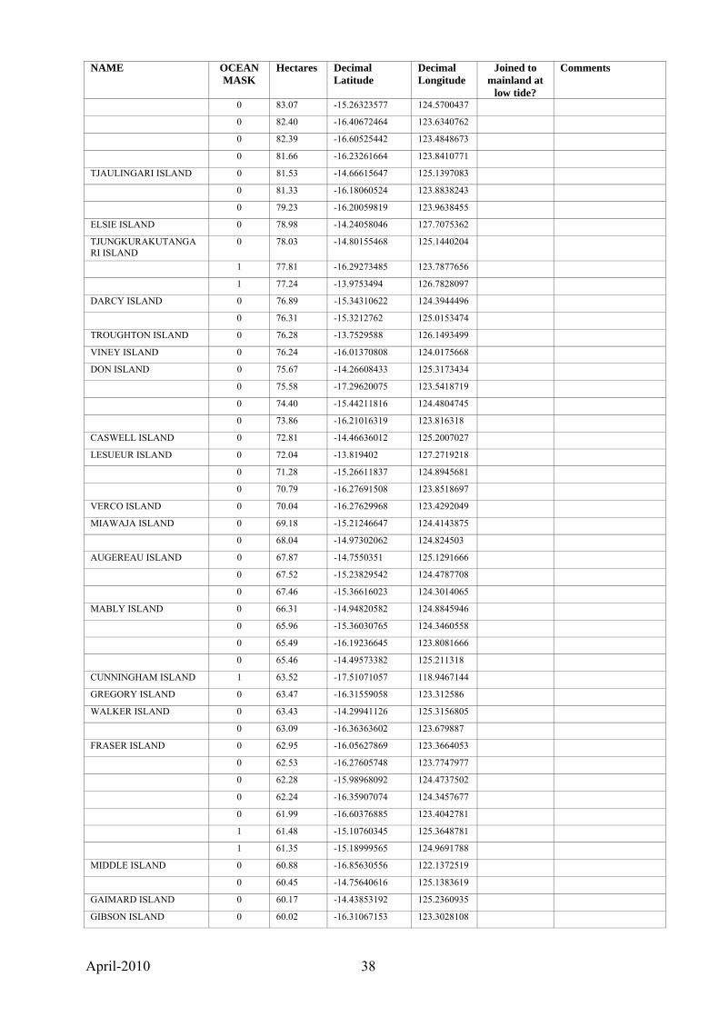
April-2010 38
NAME OCEAN MASK
Hectares Decimal Latitude
Decimal Longitude
Joined to mainland at
low tide?
Comments
0 83.07 -15.26323577 124.5700437
0 82.40 -16.40672464 123.6340762
0 82.39 -16.60525442 123.4848673
0 81.66 -16.23261664 123.8410771
TJAULINGARI ISLAND 0 81.53 -14.66615647 125.1397083
0 81.33 -16.18060524 123.8838243
0 79.23 -16.20059819 123.9638455
ELSIE ISLAND 0 78.98 -14.24058046 127.7075362
TJUNGKURAKUTANGARI ISLAND
0 78.03 -14.80155468 125.1440204
1 77.81 -16.29273485 123.7877656
1 77.24 -13.9753494 126.7828097
DARCY ISLAND 0 76.89 -15.34310622 124.3944496
0 76.31 -15.3212762 125.0153474
TROUGHTON ISLAND 0 76.28 -13.7529588 126.1493499
VINEY ISLAND 0 76.24 -16.01370808 124.0175668
DON ISLAND 0 75.67 -14.26608433 125.3173434
0 75.58 -17.29620075 123.5418719
0 74.40 -15.44211816 124.4804745
0 73.86 -16.21016319 123.816318
CASWELL ISLAND 0 72.81 -14.46636012 125.2007027
LESUEUR ISLAND 0 72.04 -13.819402 127.2719218
0 71.28 -15.26611837 124.8945681
0 70.79 -16.27691508 123.8518697
VERCO ISLAND 0 70.04 -16.27629968 123.4292049
MIAWAJA ISLAND 0 69.18 -15.21246647 124.4143875
0 68.04 -14.97302062 124.824503
AUGEREAU ISLAND 0 67.87 -14.7550351 125.1291666
0 67.52 -15.23829542 124.4787708
0 67.46 -15.36616023 124.3014065
MABLY ISLAND 0 66.31 -14.94820582 124.8845946
0 65.96 -15.36030765 124.3460558
0 65.49 -16.19236645 123.8081666
0 65.46 -14.49573382 125.211318
CUNNINGHAM ISLAND 1 63.52 -17.51071057 118.9467144
GREGORY ISLAND 0 63.47 -16.31559058 123.312586
WALKER ISLAND 0 63.43 -14.29941126 125.3156805
0 63.09 -16.36363602 123.679887
FRASER ISLAND 0 62.95 -16.05627869 123.3664053
0 62.53 -16.27605748 123.7747977
0 62.28 -15.98968092 124.4737502
0 62.24 -16.35907074 124.3457677
0 61.99 -16.60376885 123.4042781
1 61.48 -15.10760345 125.3648781
1 61.35 -15.18999565 124.9691788
MIDDLE ISLAND 0 60.88 -16.85630556 122.1372519
0 60.45 -14.75640616 125.1383619
GAIMARD ISLAND 0 60.17 -14.43853192 125.2360935
GIBSON ISLAND 0 60.02 -16.31067153 123.3028108

April-2010 39
NAME OCEAN MASK
Hectares Decimal Latitude
Decimal Longitude
Joined to mainland at
low tide?
Comments
WOODWARD ISLAND 0 59.97 -14.85211271 124.7342805
0 59.13 -14.15764309 125.7695205
0 58.47 -14.93680068 124.86895
0 58.16 -16.17109212 124.074304
LUCAS ISLAND 0 57.76 -15.20825084 124.4923873
WEST ROCK 0 56.79 -14.3261806 125.9248125 Osborn Islands
1 56.34 -16.760865 123.740873
BEDWELL ISLAND 1 56.29 -17.26511379 119.3561973
0 56.23 -15.37237129 124.6322072
0 55.94 -16.22638214 123.9527583
TURBIN ISLAND 0 55.81 -14.47848387 125.0026042
VALENTINE ISLAND 0 55.48 -17.08633607 123.3186118
RANKIN ISLAND 0 55.22 -16.32077618 124.3911165
HANCOCK ISLAND 0 54.22 -16.42743679 123.1590938
0 53.43 -14.53913474 125.4090193
0 52.93 -15.43463409 125.0086833
LAUANGI ISLAND 0 52.85 -14.1790284 125.6667128
0 52.07 -15.12749318 125.3763663
0 52.06 -16.21988868 123.4959521
COMBE HILL ISLAND 0 51.75 -14.49831399 125.3416408
0 51.01 -16.33891873 123.4186297
WHITLEY ISLAND 0 50.51 -14.93533891 124.6958421
0 50.48 -14.55456581 125.3255364
0 50.29 -15.84498141 124.4530922
0 50.16 -15.04483424 128.128586
0 49.88 -15.97375697 124.0752906
ERIC ISLAND 0 49.24 -14.26013622 127.7301224
0 47.37 -14.90725983 125.2269704
FONTANES ISLAND 0 47.12 -14.89375237 124.9235695
MARGARET ISLAND 0 47.12 -16.37496753 123.3919277
PARRY ISLAND 0 47.10 -14.32468776 125.7666824
EAST GOVERNOR ISLAND
0 46.30 -13.94637847 126.7046323 Governor Islands
KATHLEEN ISLAND 0 45.90 -16.06573088 123.5562013
NGLAYU ISLAND 0 44.89 -14.35193739 125.713001
LASERON ISLAND 0 44.38 -15.23123926 124.517957
0 44.23 -14.90888057 124.9038879
ARBIDEJ ISLAND 0 44.17 -16.19934686 123.5439124
1 44.13 -15.49005762 124.9913604
0 43.70 -14.51755371 124.9284168 largest of Albert Islands
SALURAL ISLAND 0 43.52 -16.38577427 123.1311876
RACINE ISLAND 0 43.15 -14.26360518 125.8270181
0 42.59 -16.0424866 123.2814991
LAGRANGE ISLAND 0 42.05 -14.21203711 125.7667461
0 42.03 -14.51258827 125.3371855
BRUEN ISLAND 0 41.75 -16.06577192 123.3808524
0 40.93 -14.4799175 125.2545186
RUSSELL ISLAND 0 40.79 -15.23214954 128.0970488
0 40.63 -14.64568682 125.2738165

April-2010 40
NAME OCEAN MASK
Hectares Decimal Latitude
Decimal Longitude
Joined to mainland at
low tide?
Comments
0 40.35 -15.32846516 124.3203457
0 39.98 -14.40758325 125.4290634
ETISUS ISLAND 0 39.85 -15.2390175 124.4250767
0 39.69 -16.27103305 123.8250785
0 39.60 -16.3255247 123.6311485
0 39.20 -16.36917382 124.3627146
0 38.71 -16.22175407 123.5597783
HENEY ISLAND 0 38.55 -16.49714608 123.3842105
LULIM ISLAND 0 38.47 -15.54460084 124.4131537
0 38.41 -15.06958526 125.3023909
0 38.07 -14.95974142 125.1776967
1 37.98 -15.56304769 125.2200636
0 37.72 -16.20120119 123.8679551
CLEGHORN ISLAND 0 37.52 -14.36595218 125.4049319
0 36.91 -15.43672354 124.4938645
FOLLY ISLAND 0 36.82 -16.37790167 123.4253563
0 36.82 -15.00895559 124.8453757
1 36.78 -16.38014633 124.2021455
0 36.66 -16.13580301 124.0682876
0 36.64 -15.28461195 124.4972618
PYRENE ISLAND 0 36.52 -15.25620126 124.4054004
MALCOLM ISLAND 0 35.94 -14.5214774 125.9062038
MOLIERE ISLAND 0 35.58 -14.22964165 125.8269083
WARING ISLAND 0 34.80 -15.01335869 124.7986282
0 34.68 -14.63603777 125.0927456
ATYS ISLAND 0 34.66 -15.23951392 124.5192034
BAUDIN ISLAND 0 34.50 -14.12747585 125.6051571 Institut Islands
MIDWAY ISLAND 0 34.23 -15.2821211 124.8675488
1 33.66 -18.71608261 121.6628991
0 33.65 -15.25945198 124.5825835
1 33.53 -16.58445266 123.5713731
0 33.50 -16.37613998 123.6060968
0 33.05 -14.66881334 125.2063241
LAPLACE ISLAND 0 32.86 -14.18995364 125.6592403 Institut Islands
TROCHUS ISLAND 0 32.57 -14.48489199 125.4925774
0 32.56 -14.53147424 125.4090346
SHALE ISLAND 0 32.21 -16.38022789 124.3402828
0 31.96 -14.7857722 125.1850567
0 31.60 -13.90112388 126.5638254
0 31.55 -16.27418771 124.2100514
EAST ROE ISLAND 0 31.43 -16.36812458 123.2260115
1 31.42 -15.11721887 124.9486162
0 31.10 -16.49000433 123.471967
0 31.09 -16.36773887 123.5012885 Mary Islands
1 31.07 -15.5507147 125.2173605
0 30.86 -14.76439647 125.1426112
NGALANGURU ISLAND 0 30.60 -15.9083982 124.3436158
WAILGWIN ISLAND 0 30.59 -15.53086872 124.4015272 Slate Islands
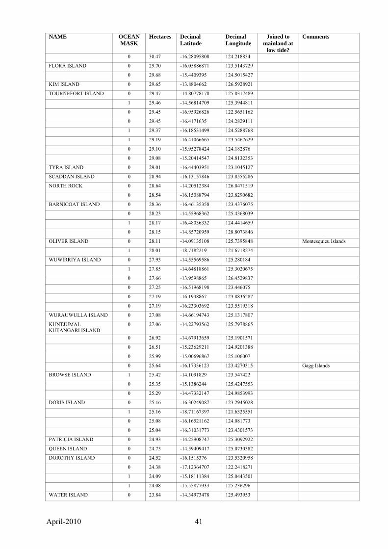
April-2010 41
NAME OCEAN MASK
Hectares Decimal Latitude
Decimal Longitude
Joined to mainland at
low tide?
Comments
0 30.47 -16.28095808 124.218834
FLORA ISLAND 0 29.70 -16.05886871 123.5143729
0 29.68 -15.4409395 124.5015427
KIM ISLAND 0 29.65 -13.8804662 126.5928921
TOURNEFORT ISLAND 0 29.47 -14.80778178 125.0317489
1 29.46 -14.56814709 125.3944811
0 29.45 -16.95926826 122.5651162
0 29.45 -16.4171635 124.2829111
1 29.37 -16.18531499 124.5288768
1 29.19 -16.41066665 123.5467629
0 29.10 -15.95278424 124.182876
0 29.08 -15.20414547 124.8132353
TYRA ISLAND 0 29.01 -16.44403951 123.1045127
SCADDAN ISLAND 0 28.94 -16.13157846 123.8555286
NORTH ROCK 0 28.64 -14.20512384 126.0471519
0 28.54 -16.15088794 123.8290682
BARNICOAT ISLAND 0 28.36 -16.46135358 123.4376075
0 28.23 -14.55968362 125.4368039
1 28.17 -16.48036332 124.4414659
0 28.15 -14.85720959 128.8073846
OLIVER ISLAND 0 28.11 -14.09135108 125.7395848 Montesquieu Islands
1 28.01 -18.7182219 121.6718274
WUWIRRIYA ISLAND 0 27.93 -14.55569586 125.280184
1 27.85 -14.64818861 125.3020675
0 27.66 -13.9598865 126.4529837
0 27.25 -16.51968198 123.446075
0 27.19 -16.1938867 123.8836287
0 27.19 -16.23303692 123.5519318
WURAUWULLA ISLAND 0 27.08 -14.66194743 125.1317807
KUNTJUMAL KUTANGARI ISLAND
0 27.06 -14.22793562 125.7978865
0 26.92 -14.67913659 125.1901571
0 26.51 -15.23629211 124.9201388
0 25.99 -15.00696867 125.106007
0 25.64 -16.17336123 123.4270315 Gagg Islands
BROWSE ISLAND 1 25.42 -14.1091829 123.547422
0 25.35 -15.1386244 125.4247553
0 25.29 -14.47332147 124.9853993
DORIS ISLAND 0 25.16 -16.30249087 123.2945028
1 25.16 -18.71167397 121.6325551
0 25.08 -16.16521162 124.081773
0 25.04 -16.31031773 123.4301573
PATRICIA ISLAND 0 24.93 -14.25908747 125.3092922
QUEEN ISLAND 0 24.73 -14.59409417 125.0730382
DOROTHY ISLAND 0 24.52 -16.1515376 123.5320958
0 24.38 -17.12364707 122.2418271
1 24.09 -15.18111384 125.0443501
1 24.08 -15.55877933 125.236296
WATER ISLAND 0 23.84 -14.34973478 125.493953
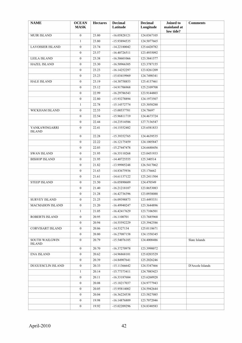
April-2010 42
NAME OCEAN MASK
Hectares Decimal Latitude
Decimal Longitude
Joined to mainland at
low tide?
Comments
MUIR ISLAND 0 23.80 -16.05828121 124.0367105
1 23.80 -15.93894535 124.5077665
LAVOISIER ISLAND 0 23.74 -14.22180042 125.6420782
0 23.57 -16.40726511 123.4935092
LEILA ISLAND 0 23.38 -16.50601066 123.3841577
HAZEL ISLAND 0 23.30 -16.50966305 123.3787155
0 23.23 -16.14252297 123.8261209
0 23.23 -15.03419969 124.7490341
HALE ISLAND 0 23.19 -14.38758853 125.4137461
0 23.12 -14.91706968 125.2109708
0 22.99 -16.29786543 123.9144803
0 22.80 -15.93278894 124.1973507
1 22.78 -15.14572774 125.3058288
WICKHAM ISLAND 0 22.55 -15.00537701 124.78697
0 22.54 -15.96811719 124.4673724
0 22.44 -14.23514586 127.7136547
YANKAWINGARRI ISLAND
0 22.41 -14.15552482 125.6581833
0 22.28 -15.39352765 124.4639535
0 22.22 -16.12175459 124.1005847
0 22.03 -15.27447478 124.6688456
SWAN ISLAND 0 21.95 -16.35110268 123.0451933
BISHOP ISLAND 0 21.95 -14.40725555 125.340514
0 21.82 -13.99905248 126.5417062
0 21.63 -14.83675936 125.176662
0 21.61 -14.61137122 125.2411504
STEEP ISLAND 0 21.50 -16.05890609 124.470549
0 21.40 -16.21218107 123.8653083
0 21.28 -16.42736396 123.0938088
SURVEY ISLAND 0 21.25 -16.09398873 123.4493331
MACMAHON ISLAND 0 21.20 -16.49940247 123.3644896
1 21.05 -16.42417629 123.7106501
ROBERTS ISLAND 0 20.95 -16.1100701 123.7685968
0 20.94 -14.55592229 125.3942586
CORVISART ISLAND 0 20.86 -14.5327134 125.0118671
0 20.80 -16.27087158 124.1558345
SOUTH WAILGWIN ISLAND
0 20.79 -15.54076185 124.4008486 Slate Islands
0 20.70 -16.37270978 123.3990072
ENA ISLAND 0 20.62 -14.96868101 125.0203529
0 20.39 -14.84907641 125.2026246
DUGUESCLIN ISLAND 0 20.33 -15.11366642 124.5347466 D'Arcole Islands
1 20.14 -15.77373411 124.7085423
0 20.11 -16.33187684 123.6260928
0 20.08 -15.18217037 124.9777943
0 20.05 -15.95814002 124.5942644
0 20.04 -16.36224538 123.5827085
0 19.98 -16.14876809 123.7072046
0 19.92 -15.02209296 124.8340583

April-2010 43
NAME OCEAN MASK
Hectares Decimal Latitude
Decimal Longitude
Joined to mainland at
low tide?
Comments
0 19.91 -16.28620175 124.2320261
1 19.86 -15.78692556 124.707191
SLADE ISLAND 0 19.77 -15.49155064 124.5572236
CAESAR ISLAND 0 19.70 -16.06555384 123.9344385
0 19.54 -15.31488729 124.780132
0 19.52 -16.08472619 124.0651183
0 19.49 -14.64751791 125.1631138
HECLA ISLAND 0 19.44 -13.97803115 126.0005493
PELICAN ISLAND 0 19.37 -14.76835158 128.7748538
0 19.26 -16.24588808 123.5537965
0 19.21 -15.32223549 124.2451787
1 19.13 -15.1534645 125.3236774
0 19.13 -14.89352366 124.8858348 Desaix Islands
1 19.11 -13.99811159 126.815196
JUSSIEU ISLAND 0 19.06 -14.71196465 124.9767846
0 18.99 -15.2672405 124.3476593
HUMMOCK ISLAND 0 18.79 -15.32161297 124.6204017
0 18.54 -16.260945 123.8326188
0 18.46 -16.2321523 123.8590678
0 18.30 -15.02745839 125.283793
1 18.27 -14.89522883 125.3073884
0 18.24 -16.38111345 123.4421336
0 18.14 -15.38778353 124.4683886
0 18.13 -15.15523096 128.1291967
1 18.03 -15.10391592 125.374697
0 18.00 -14.58855885 125.4463747
WIIRRA ISLAND 0 17.93 -14.58087494 125.225179
0 17.91 -16.26536272 123.5528716
0 17.81 -13.691145 126.916118
JONES ISLAND 0 17.64 -13.75695209 126.3596635
HELIPAD ISLAND 0 17.61 -16.27140763 124.1706967
0 17.60 -14.81366919 128.711686
0 17.55 -16.19702941 123.6033316
0 17.33 -14.34704288 126.0019259
1 17.26 -16.63664054 123.5429501
MCINTYRE ISLAND 0 17.25 -15.98741873 123.5382993
SAND ISLAND 0 17.05 -13.85108019 125.8053894
1 16.99 -15.46655302 125.0893458
1 16.92 -14.65387867 125.32152
0 16.48 -15.17020984 124.6529341
0 16.43 -15.94470567 124.4904993
BONAPARTE ISLAND 0 16.43 -14.85529796 124.7690995
0 16.36 -16.26630941 123.5733285
0 16.30 -14.80392615 128.4481929
THAIS ISLAND 0 16.03 -14.96018393 125.1605045
HAWICK ISLAND 0 16.00 -14.33612827 125.3806252
1 15.81 -16.60152687 123.5545686
WANGANIA ISLAND 0 15.79 -16.02659463 123.5427212
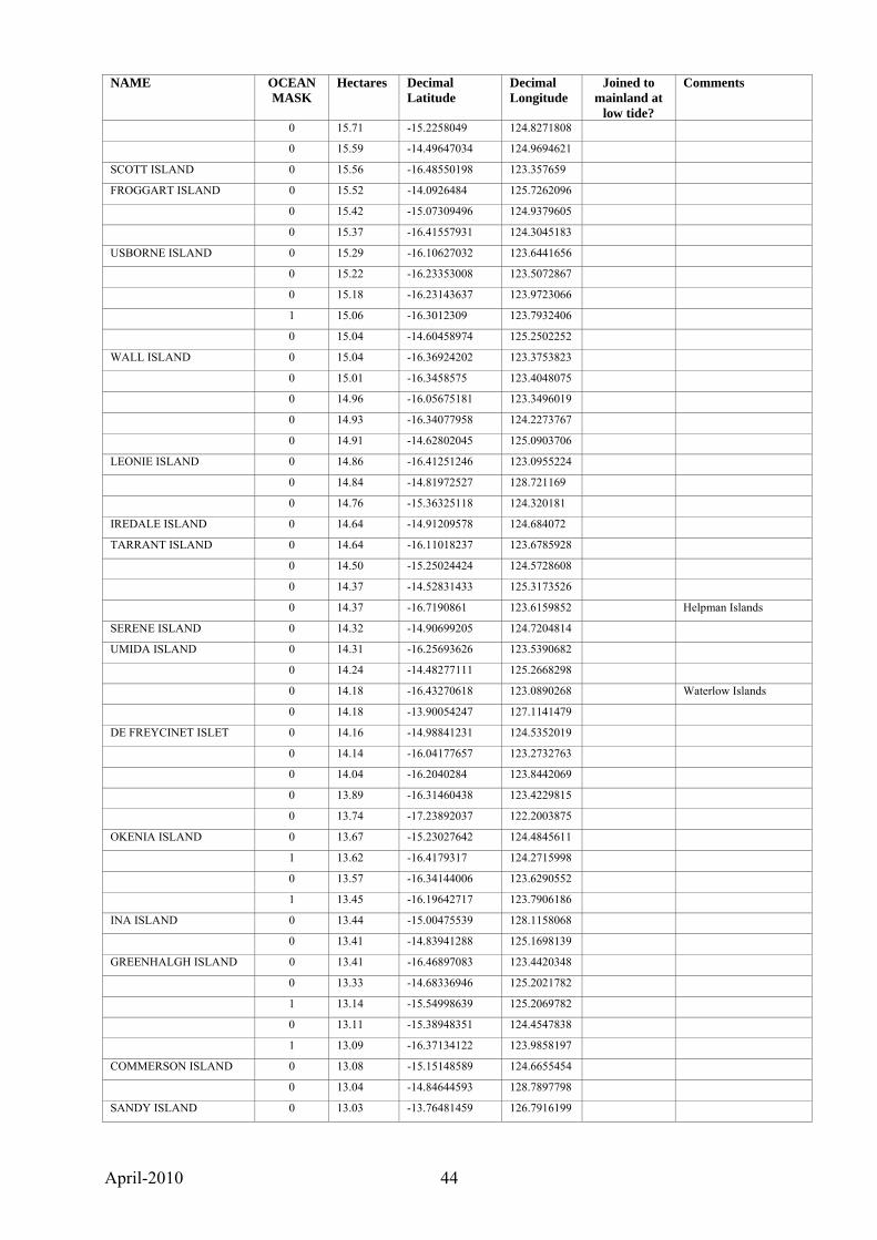
April-2010 44
NAME OCEAN MASK
Hectares Decimal Latitude
Decimal Longitude
Joined to mainland at
low tide?
Comments
0 15.71 -15.2258049 124.8271808
0 15.59 -14.49647034 124.9694621
SCOTT ISLAND 0 15.56 -16.48550198 123.357659
FROGGART ISLAND 0 15.52 -14.0926484 125.7262096
0 15.42 -15.07309496 124.9379605
0 15.37 -16.41557931 124.3045183
USBORNE ISLAND 0 15.29 -16.10627032 123.6441656
0 15.22 -16.23353008 123.5072867
0 15.18 -16.23143637 123.9723066
1 15.06 -16.3012309 123.7932406
0 15.04 -14.60458974 125.2502252
WALL ISLAND 0 15.04 -16.36924202 123.3753823
0 15.01 -16.3458575 123.4048075
0 14.96 -16.05675181 123.3496019
0 14.93 -16.34077958 124.2273767
0 14.91 -14.62802045 125.0903706
LEONIE ISLAND 0 14.86 -16.41251246 123.0955224
0 14.84 -14.81972527 128.721169
0 14.76 -15.36325118 124.320181
IREDALE ISLAND 0 14.64 -14.91209578 124.684072
TARRANT ISLAND 0 14.64 -16.11018237 123.6785928
0 14.50 -15.25024424 124.5728608
0 14.37 -14.52831433 125.3173526
0 14.37 -16.7190861 123.6159852 Helpman Islands
SERENE ISLAND 0 14.32 -14.90699205 124.7204814
UMIDA ISLAND 0 14.31 -16.25693626 123.5390682
0 14.24 -14.48277111 125.2668298
0 14.18 -16.43270618 123.0890268 Waterlow Islands
0 14.18 -13.90054247 127.1141479
DE FREYCINET ISLET 0 14.16 -14.98841231 124.5352019
0 14.14 -16.04177657 123.2732763
0 14.04 -16.2040284 123.8442069
0 13.89 -16.31460438 123.4229815
0 13.74 -17.23892037 122.2003875
OKENIA ISLAND 0 13.67 -15.23027642 124.4845611
1 13.62 -16.4179317 124.2715998
0 13.57 -16.34144006 123.6290552
1 13.45 -16.19642717 123.7906186
INA ISLAND 0 13.44 -15.00475539 128.1158068
0 13.41 -14.83941288 125.1698139
GREENHALGH ISLAND 0 13.41 -16.46897083 123.4420348
0 13.33 -14.68336946 125.2021782
1 13.14 -15.54998639 125.2069782
0 13.11 -15.38948351 124.4547838
1 13.09 -16.37134122 123.9858197
COMMERSON ISLAND 0 13.08 -15.15148589 124.6655454
0 13.04 -14.84644593 128.7897798
SANDY ISLAND 0 13.03 -13.76481459 126.7916199
April-2010 45
NAME OCEAN MASK
Hectares Decimal Latitude
Decimal Longitude
Joined to mainland at
low tide?
Comments
0 13.01 -16.24096917 124.0421215
FLAT ISLAND 0 12.95 -14.15203629 125.7002367
DAMPIERS MONUMENT 0 12.95 -16.12602943 123.4405244
0 12.91 -16.57965785 123.5407061
0 12.89 -14.47234828 125.2004967
0 12.83 -15.15463203 124.6732662
GREEN ISLAND 0 12.78 -15.4757367 124.6009425
0 12.77 -15.0310996 124.6080906
STERNA ISLAND 0 12.76 -14.10718158 125.7485463 Montesquieu Islands
0 12.75 -15.24266172 124.53724
0 12.68 -16.04180416 123.3615531
0 12.66 -16.26709431 124.1429678
0 12.65 -15.39372765 124.4698871
0 12.38 -15.08471507 125.261283
0 12.37 -14.21644225 126.5898879
1 12.31 -16.43007632 123.6748972
1 12.23 -16.40255677 124.4998432
0 12.23 -14.8899503 125.2512974
0 12.10 -16.31403954 123.2770204 Salier Islands
0 12.05 -13.95553984 126.8156244
1 12.05 -16.50190487 124.4391973
0 12.02 -16.17059968 123.4197534
0 11.98 -16.34706977 123.8825695
0 11.95 -15.08603975 125.2570788
0 11.93 -15.93021111 124.2048481
MIDDLE ISLAND 0 11.92 -16.44803393 123.0874595
1 11.86 -16.80879804 123.7712982
0 11.83 -14.56935963 125.4204405
RED ISLAND 0 11.79 -15.21275865 124.2599933
CENTRE ROCK 0 11.77 -14.32582319 125.943902
0 11.74 -16.06232699 123.3666618
0 11.62 -16.31037018 123.8526705
0 11.61 -15.16860579 125.0414413
KANGGURRYU ISLAND 0 11.61 -14.72249753 128.6349431
0 11.57 -16.27489298 124.1634377
0 11.53 -15.26936589 128.089144
0 11.53 -16.17713327 123.808959
0 11.49 -15.05441419 125.2943611
0 11.48 -14.47502853 125.4030354
0 11.46 -16.30736822 124.3703841
0 11.42 -16.38526949 123.4452187 Muddle Islands
0 11.36 -14.56417138 125.3149757
1 11.29 -14.63195012 125.2259463
1 11.27 -16.28138301 123.5501699
0 11.26 -16.26108748 123.5715046
0 11.16 -14.91594412 125.1409149
0 11.12 -16.15399067 123.8349429
0 11.08 -16.30504039 123.3079533
April-2010 46
NAME OCEAN MASK
Hectares Decimal Latitude
Decimal Longitude
Joined to mainland at
low tide?
Comments
0 11.05 -16.43702796 123.0923953
ATRINA ISLAND 0 10.99 -15.22991534 124.4946349
SUFFREN ISLAND 0 10.99 -14.541635 124.9287533
0 10.90 -14.4046671 125.5245087
MCCULLOCH ISLAND 0 10.83 -14.93577936 124.6756101
TREE ISLAND 0 10.82 -16.65591861 123.484016
KOLGANU ISLAND 0 10.79 -16.39818626 123.1626757
0 10.77 -16.18246481 123.810011
0 10.69 -16.28213959 123.8238186
0 10.68 -14.9825682 125.2060742
0 10.63 -16.31297114 123.4148356
0 10.59 -16.23323711 123.8082448
0 10.54 -16.23683635 124.0544406
0 10.48 -16.39422622 124.2742424
0 10.46 -15.52957048 124.4602368
0 10.43 -16.45167409 123.5585978 Razor Islands
0 10.41 -14.79396768 125.1735009
0 10.40 -16.36428281 123.4290755
0 10.39 -14.35699821 125.4261389
1 10.33 -16.60621906 123.5523361
0 10.29 -16.34012862 123.8730808
0 10.23 -14.77409667 125.146395
0 10.21 -15.29478354 124.5769967
0 10.14 -14.4977438 125.4960322
0 10.10 -16.13768117 123.4630604 Finch Islands
0 10.10 -16.57469786 123.3175858 Fairway Islands
0 10.07 -15.30831011 124.2561702
0 10.07 -16.1697491 123.4107687
0 10.05 -14.59378516 125.4258308
GILL ISLAND 1 10.04 -15.76480616 124.7543867
0 10.03 -14.85722303 128.8222083
0 9.98 -16.30005511 124.1990482
0 9.95 -14.4648984 124.9806629
0 9.94 -16.09872751 123.4448749
0 9.91 -15.45235354 124.6099862
0 9.83 -15.3536708 124.3603358
0 9.82 -16.51891814 122.8594952
0 9.79 -16.3190011 123.8674427
GABRIEL ISLAND 0 9.78 -14.09787086 125.7487302
1 9.77 -16.1990143 124.6129016
0 9.74 -14.2042754 125.640749
0 9.66 -14.82972749 125.1800151
ROUND ISLAND 0 9.62 -16.16271572 123.7688685
0 9.60 -15.0305257 125.2531548
0 9.59 -14.76858614 128.5612411
0 9.59 -14.33472441 125.5888302
LATIRUS ISLAND 0 9.52 -15.23018393 124.5246347
0 9.47 -14.59533744 125.0929026
April-2010 47
NAME OCEAN MASK
Hectares Decimal Latitude
Decimal Longitude
Joined to mainland at
low tide?
Comments
0 9.46 -16.03356378 123.5536125
0 9.43 -14.92016079 125.1489402
1 9.40 -15.1972914 125.0308065
0 9.34 -14.56522006 125.4213984
RATHBUN ISLAND 0 9.31 -14.9313467 124.6796431
TREE ISLAND 0 9.28 -16.38668996 123.3094748
0 9.27 -14.48704462 125.2451468
0 9.25 -14.14788641 126.5544682
0 9.24 -16.20071634 123.8902011
COTTON ISLAND 0 9.23 -14.90611934 124.7255686
0 9.22 -14.69093944 125.1935271
0 9.16 -15.22722476 124.8143479
0 9.13 -13.95968678 127.1296934
1 9.04 -15.89075123 124.4765877
KING ISLAND 0 9.02 -15.87238923 123.6366021 Macleay Islands
0 9.00 -14.6422565 125.0652648
0 8.94 -16.15637849 124.0823668
0 8.93 -14.5362668 124.9343796
WULAJARLU ISLAND 0 8.90 -15.95376614 124.3055426
0 8.88 -14.7866227 125.0180403
0 8.85 -16.22131559 123.4423757
0 8.77 -14.82307258 125.1810444
1 8.74 -14.57409276 125.4619559
0 8.73 -14.40405331 124.9564167
0 8.71 -14.8787524 128.9656565
CLEFT ISLAND 0 8.70 -16.03599158 123.3516827
0 8.67 -14.49815797 125.3768983
OTWAY ISLAND 0 8.66 -15.26991158 128.1046227
0 8.66 -16.19207409 123.4476163
1 8.65 -16.41711037 124.2646552
0 8.63 -14.78612317 128.569532
0 8.61 -16.29828663 123.9214878
0 8.57 -15.00305105 125.4704517
CUSSEN ISLAND 0 8.56 -16.38954726 123.4679886
0 8.55 -16.40808583 123.6750465
0 8.53 -14.82601252 128.7258863
POPE ISLAND 0 8.50 -16.49121522 123.3651745
0 8.46 -15.52147344 124.6216827
1 8.46 -16.61325615 123.5568446
0 8.45 -14.09167869 126.313942
PASCAL ISLAND 0 8.39 -14.06726216 125.651795
0 8.34 -14.59380552 125.2112242
0 8.31 -16.33421655 123.8760038
ROCKY ISLAND 0 8.27 -14.09479797 127.5489787
0 8.24 -16.32992047 123.8811821
1 8.23 -14.65141863 125.2475348
0 8.23 -14.57479274 125.3689408
BAT ISLAND 0 8.22 -15.10389143 124.9077253
April-2010 48
NAME OCEAN MASK
Hectares Decimal Latitude
Decimal Longitude
Joined to mainland at
low tide?
Comments
1 8.22 -16.48970363 123.4799527
TALBOYS ISLAND 0 8.20 -16.39422814 123.0691181
0 8.18 -15.23277378 124.3806334
1 8.18 -16.41767719 124.274788
BERTHOUD ISLAND 0 8.17 -14.28086328 125.8382775
0 8.06 -16.03910607 123.3519502
0 8.05 -14.56146356 125.4139919
1 8.05 -16.09219379 124.5925989
0 8.05 -13.96522205 126.8730516
0 7.99 -15.46987559 124.6739676
0 7.96 -16.39427397 123.4822561
SANDY ISLAND 0 7.94 -16.88155407 122.1697299 Lacepede Islands
0 7.94 -16.16683433 123.7970269
0 7.83 -14.42077854 125.4043234
0 7.81 -14.87098671 125.2093313
0 7.76 -15.37224064 124.4377245
0 7.75 -15.42569405 124.6210324
0 7.74 -16.45847047 123.423292
0 7.72 -16.33160747 124.1994132
0 7.71 -14.90085862 124.8876499
1 7.69 -15.21607529 125.0201578
FARR ISLAND 0 7.69 -16.45000601 123.4006355 Farr Islands
0 7.66 -14.93466898 128.3053289
0 7.64 -16.07712976 124.0662497
1 7.59 -14.82807383 125.1827315
0 7.58 -15.11384774 125.1691669
0 7.56 -16.41524653 123.6769732
RANDALL ISLAND 0 7.54 -14.14314647 125.5793178 Institut Islands
0 7.53 -15.43280725 125.0573675
1 7.51 -16.17925425 123.7393979
0 7.48 -16.52688679 123.4273966
0 7.47 -14.92126997 124.9074827
0 7.46 -16.37933862 123.4340681
0 7.44 -14.61002499 125.2109212
0 7.42 -14.53751656 125.248212
0 7.42 -16.35285332 123.4040569
0 7.41 -16.18742549 123.4560697
0 7.40 -14.52423837 125.1417265
0 7.40 -14.51219019 124.9219796
0 7.37 -14.69442366 125.1992847
0 7.37 -15.23139743 124.4624755
0 7.32 -16.1702138 123.5713145
0 7.31 -15.28647897 124.2930545
1 7.30 -16.40824964 123.682478
0 7.29 -14.78313631 125.1524447
0 7.29 -14.98751454 125.0965255
0 7.28 -14.96122862 125.182713
0 7.26 -16.60744132 123.4971464
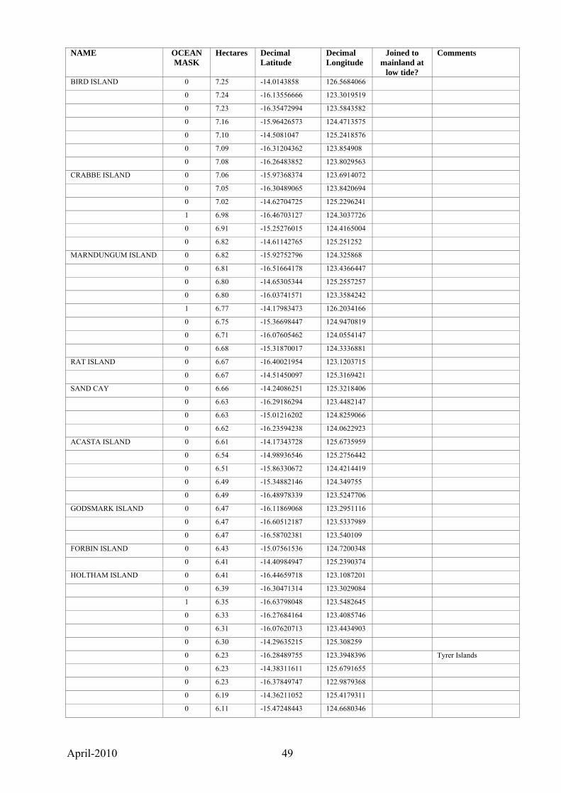
April-2010 49
NAME OCEAN MASK
Hectares Decimal Latitude
Decimal Longitude
Joined to mainland at
low tide?
Comments
BIRD ISLAND 0 7.25 -14.0143858 126.5684066
0 7.24 -16.13556666 123.3019519
0 7.23 -16.35472994 123.5843582
0 7.16 -15.96426573 124.4713575
0 7.10 -14.5081047 125.2418576
0 7.09 -16.31204362 123.854908
0 7.08 -16.26483852 123.8029563
CRABBE ISLAND 0 7.06 -15.97368374 123.6914072
0 7.05 -16.30489065 123.8420694
0 7.02 -14.62704725 125.2296241
1 6.98 -16.46703127 124.3037726
0 6.91 -15.25276015 124.4165004
0 6.82 -14.61142765 125.251252
MARNDUNGUM ISLAND 0 6.82 -15.92752796 124.325868
0 6.81 -16.51664178 123.4366447
0 6.80 -14.65305344 125.2557257
0 6.80 -16.03741571 123.3584242
1 6.77 -14.17983473 126.2034166
0 6.75 -15.36698447 124.9470819
0 6.71 -16.07605462 124.0554147
0 6.68 -15.31870017 124.3336881
RAT ISLAND 0 6.67 -16.40021954 123.1203715
0 6.67 -14.51450097 125.3169421
SAND CAY 0 6.66 -14.24086251 125.3218406
0 6.63 -16.29186294 123.4482147
0 6.63 -15.01216202 124.8259066
0 6.62 -16.23594238 124.0622923
ACASTA ISLAND 0 6.61 -14.17343728 125.6735959
0 6.54 -14.98936546 125.2756442
0 6.51 -15.86330672 124.4214419
0 6.49 -15.34882146 124.349755
0 6.49 -16.48978339 123.5247706
GODSMARK ISLAND 0 6.47 -16.11869068 123.2951116
0 6.47 -16.60512187 123.5337989
0 6.47 -16.58702381 123.540109
FORBIN ISLAND 0 6.43 -15.07561536 124.7200348
0 6.41 -14.40984947 125.2390374
HOLTHAM ISLAND 0 6.41 -16.44659718 123.1087201
0 6.39 -16.30471314 123.3029084
1 6.35 -16.63798048 123.5482645
0 6.33 -16.27684164 123.4085746
0 6.31 -16.07620713 123.4434903
0 6.30 -14.29635215 125.308259
0 6.23 -16.28489755 123.3948396 Tyrer Islands
0 6.23 -14.38311611 125.6791655
0 6.23 -16.37849747 122.9879368
0 6.19 -14.36211052 125.4179311
0 6.11 -15.47248443 124.6680346
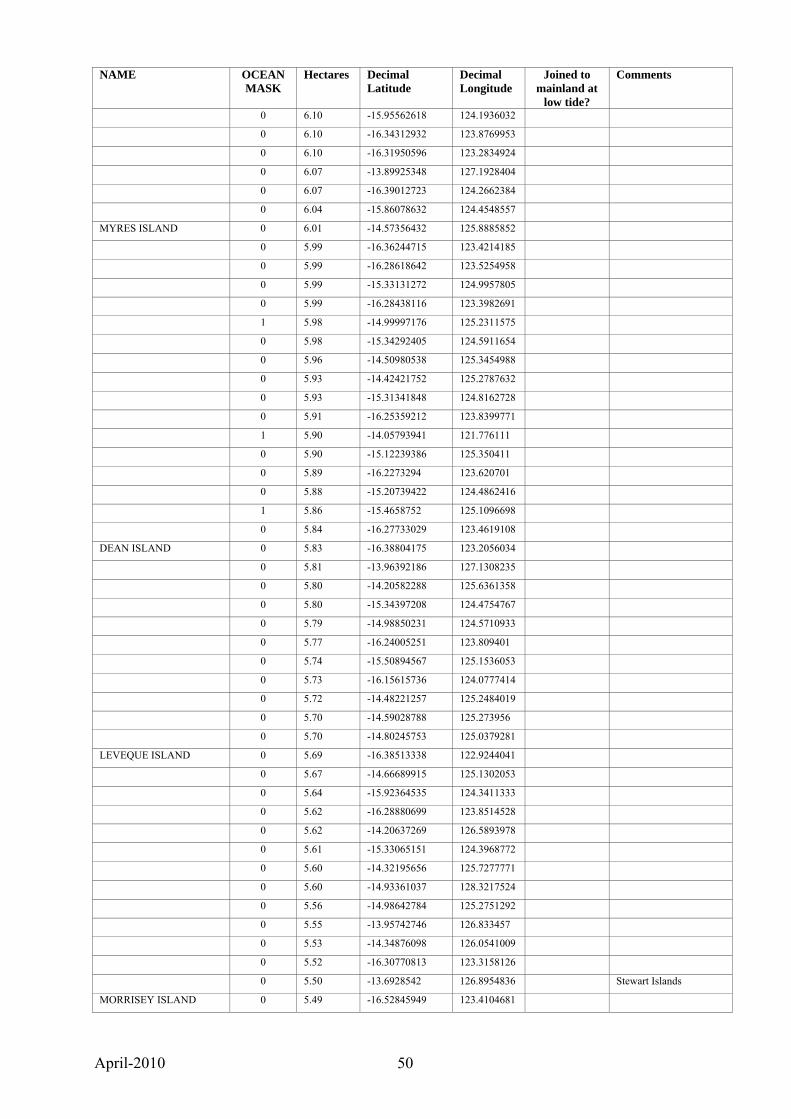
April-2010 50
NAME OCEAN MASK
Hectares Decimal Latitude
Decimal Longitude
Joined to mainland at
low tide?
Comments
0 6.10 -15.95562618 124.1936032
0 6.10 -16.34312932 123.8769953
0 6.10 -16.31950596 123.2834924
0 6.07 -13.89925348 127.1928404
0 6.07 -16.39012723 124.2662384
0 6.04 -15.86078632 124.4548557
MYRES ISLAND 0 6.01 -14.57356432 125.8885852
0 5.99 -16.36244715 123.4214185
0 5.99 -16.28618642 123.5254958
0 5.99 -15.33131272 124.9957805
0 5.99 -16.28438116 123.3982691
1 5.98 -14.99997176 125.2311575
0 5.98 -15.34292405 124.5911654
0 5.96 -14.50980538 125.3454988
0 5.93 -14.42421752 125.2787632
0 5.93 -15.31341848 124.8162728
0 5.91 -16.25359212 123.8399771
1 5.90 -14.05793941 121.776111
0 5.90 -15.12239386 125.350411
0 5.89 -16.2273294 123.620701
0 5.88 -15.20739422 124.4862416
1 5.86 -15.4658752 125.1096698
0 5.84 -16.27733029 123.4619108
DEAN ISLAND 0 5.83 -16.38804175 123.2056034
0 5.81 -13.96392186 127.1308235
0 5.80 -14.20582288 125.6361358
0 5.80 -15.34397208 124.4754767
0 5.79 -14.98850231 124.5710933
0 5.77 -16.24005251 123.809401
0 5.74 -15.50894567 125.1536053
0 5.73 -16.15615736 124.0777414
0 5.72 -14.48221257 125.2484019
0 5.70 -14.59028788 125.273956
0 5.70 -14.80245753 125.0379281
LEVEQUE ISLAND 0 5.69 -16.38513338 122.9244041
0 5.67 -14.66689915 125.1302053
0 5.64 -15.92364535 124.3411333
0 5.62 -16.28880699 123.8514528
0 5.62 -14.20637269 126.5893978
0 5.61 -15.33065151 124.3968772
0 5.60 -14.32195656 125.7277771
0 5.60 -14.93361037 128.3217524
0 5.56 -14.98642784 125.2751292
0 5.55 -13.95742746 126.833457
0 5.53 -14.34876098 126.0541009
0 5.52 -16.30770813 123.3158126
0 5.50 -13.6928542 126.8954836 Stewart Islands
MORRISEY ISLAND 0 5.49 -16.52845949 123.4104681
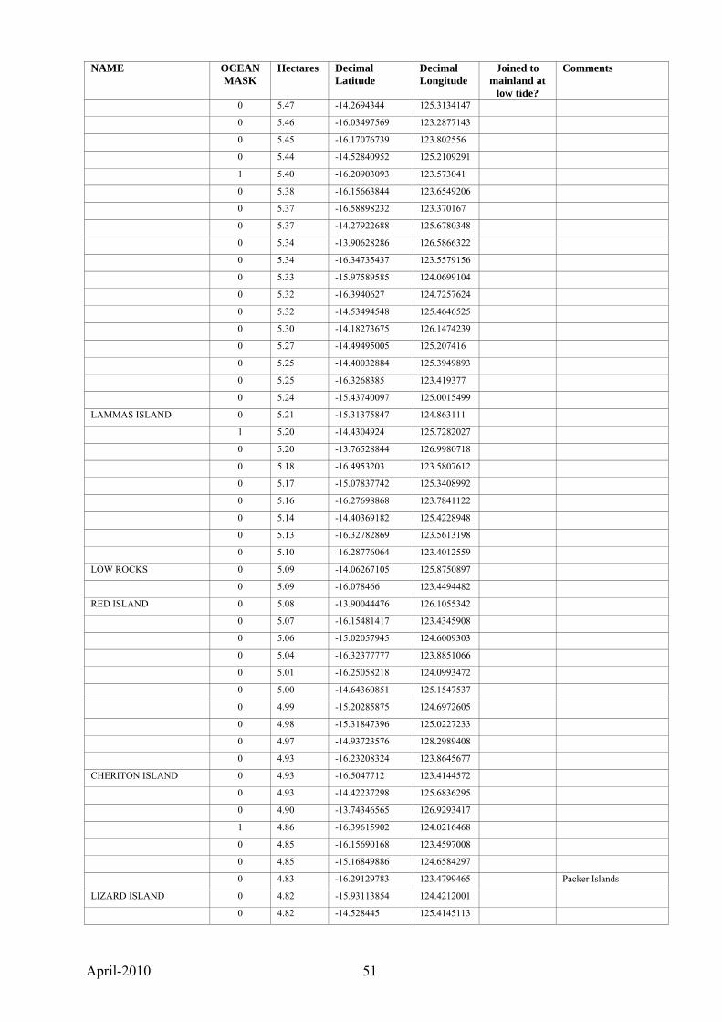
April-2010 51
NAME OCEAN MASK
Hectares Decimal Latitude
Decimal Longitude
Joined to mainland at
low tide?
Comments
0 5.47 -14.2694344 125.3134147
0 5.46 -16.03497569 123.2877143
0 5.45 -16.17076739 123.802556
0 5.44 -14.52840952 125.2109291
1 5.40 -16.20903093 123.573041
0 5.38 -16.15663844 123.6549206
0 5.37 -16.58898232 123.370167
0 5.37 -14.27922688 125.6780348
0 5.34 -13.90628286 126.5866322
0 5.34 -16.34735437 123.5579156
0 5.33 -15.97589585 124.0699104
0 5.32 -16.3940627 124.7257624
0 5.32 -14.53494548 125.4646525
0 5.30 -14.18273675 126.1474239
0 5.27 -14.49495005 125.207416
0 5.25 -14.40032884 125.3949893
0 5.25 -16.3268385 123.419377
0 5.24 -15.43740097 125.0015499
LAMMAS ISLAND 0 5.21 -15.31375847 124.863111
1 5.20 -14.4304924 125.7282027
0 5.20 -13.76528844 126.9980718
0 5.18 -16.4953203 123.5807612
0 5.17 -15.07837742 125.3408992
0 5.16 -16.27698868 123.7841122
0 5.14 -14.40369182 125.4228948
0 5.13 -16.32782869 123.5613198
0 5.10 -16.28776064 123.4012559
LOW ROCKS 0 5.09 -14.06267105 125.8750897
0 5.09 -16.078466 123.4494482
RED ISLAND 0 5.08 -13.90044476 126.1055342
0 5.07 -16.15481417 123.4345908
0 5.06 -15.02057945 124.6009303
0 5.04 -16.32377777 123.8851066
0 5.01 -16.25058218 124.0993472
0 5.00 -14.64360851 125.1547537
0 4.99 -15.20285875 124.6972605
0 4.98 -15.31847396 125.0227233
0 4.97 -14.93723576 128.2989408
0 4.93 -16.23208324 123.8645677
CHERITON ISLAND 0 4.93 -16.5047712 123.4144572
0 4.93 -14.42237298 125.6836295
0 4.90 -13.74346565 126.9293417
1 4.86 -16.39615902 124.0216468
0 4.85 -16.15690168 123.4597008
0 4.85 -15.16849886 124.6584297
0 4.83 -16.29129783 123.4799465 Packer Islands
LIZARD ISLAND 0 4.82 -15.93113854 124.4212001
0 4.82 -14.528445 125.4145113
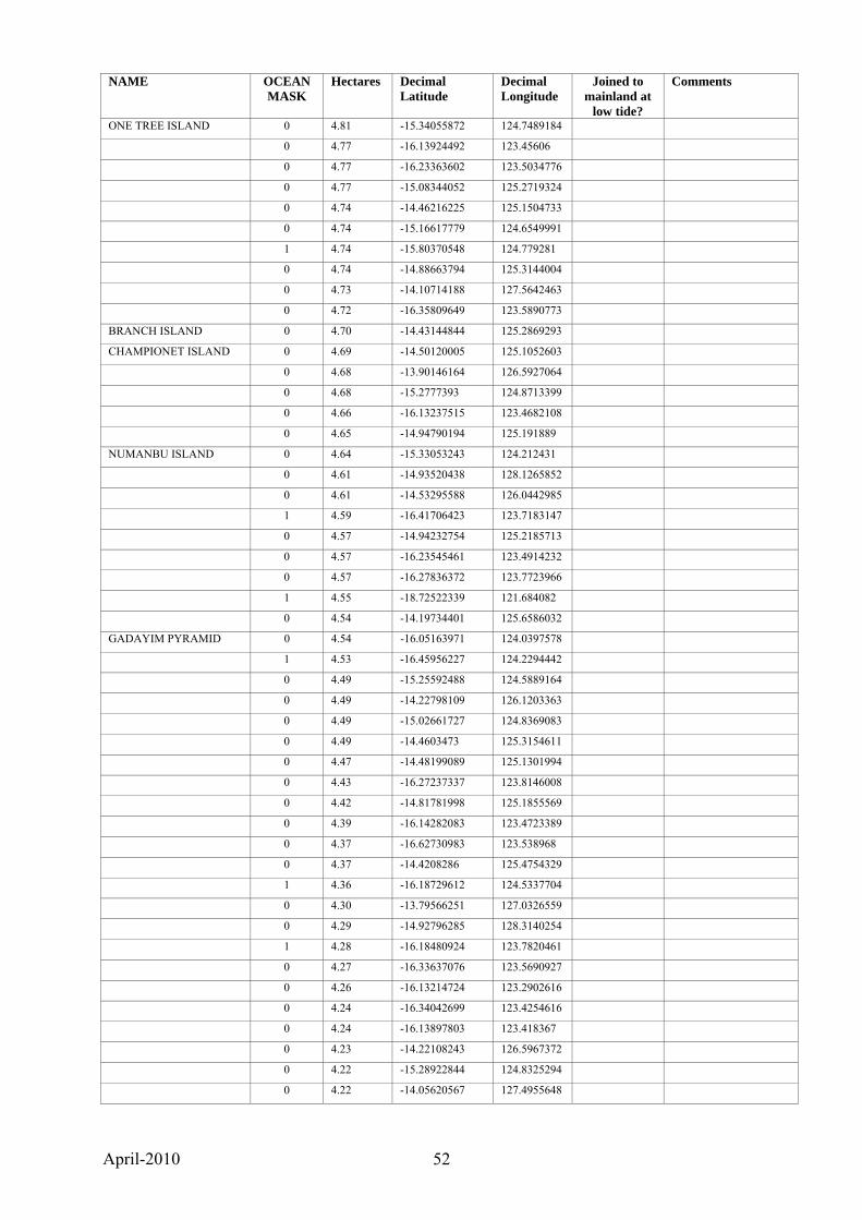
April-2010 52
NAME OCEAN MASK
Hectares Decimal Latitude
Decimal Longitude
Joined to mainland at
low tide?
Comments
ONE TREE ISLAND 0 4.81 -15.34055872 124.7489184
0 4.77 -16.13924492 123.45606
0 4.77 -16.23363602 123.5034776
0 4.77 -15.08344052 125.2719324
0 4.74 -14.46216225 125.1504733
0 4.74 -15.16617779 124.6549991
1 4.74 -15.80370548 124.779281
0 4.74 -14.88663794 125.3144004
0 4.73 -14.10714188 127.5642463
0 4.72 -16.35809649 123.5890773
BRANCH ISLAND 0 4.70 -14.43144844 125.2869293
CHAMPIONET ISLAND 0 4.69 -14.50120005 125.1052603
0 4.68 -13.90146164 126.5927064
0 4.68 -15.2777393 124.8713399
0 4.66 -16.13237515 123.4682108
0 4.65 -14.94790194 125.191889
NUMANBU ISLAND 0 4.64 -15.33053243 124.212431
0 4.61 -14.93520438 128.1265852
0 4.61 -14.53295588 126.0442985
1 4.59 -16.41706423 123.7183147
0 4.57 -14.94232754 125.2185713
0 4.57 -16.23545461 123.4914232
0 4.57 -16.27836372 123.7723966
1 4.55 -18.72522339 121.684082
0 4.54 -14.19734401 125.6586032
GADAYIM PYRAMID 0 4.54 -16.05163971 124.0397578
1 4.53 -16.45956227 124.2294442
0 4.49 -15.25592488 124.5889164
0 4.49 -14.22798109 126.1203363
0 4.49 -15.02661727 124.8369083
0 4.49 -14.4603473 125.3154611
0 4.47 -14.48199089 125.1301994
0 4.43 -16.27237337 123.8146008
0 4.42 -14.81781998 125.1855569
0 4.39 -16.14282083 123.4723389
0 4.37 -16.62730983 123.538968
0 4.37 -14.4208286 125.4754329
1 4.36 -16.18729612 124.5337704
0 4.30 -13.79566251 127.0326559
0 4.29 -14.92796285 128.3140254
1 4.28 -16.18480924 123.7820461
0 4.27 -16.33637076 123.5690927
0 4.26 -16.13214724 123.2902616
0 4.24 -16.34042699 123.4254616
0 4.24 -16.13897803 123.418367
0 4.23 -14.22108243 126.5967372
0 4.22 -15.28922844 124.8325294
0 4.22 -14.05620567 127.4955648
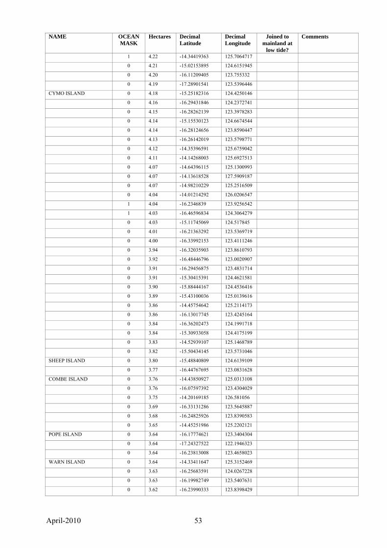
April-2010 53
NAME OCEAN MASK
Hectares Decimal Latitude
Decimal Longitude
Joined to mainland at
low tide?
Comments
1 4.22 -14.34419363 125.7064717
0 4.21 -15.02153895 124.6151945
0 4.20 -16.11209405 123.755332
0 4.19 -17.28901541 123.5396446
CYMO ISLAND 0 4.18 -15.25182316 124.4250146
0 4.16 -16.29431846 124.2372741
0 4.15 -16.28262139 123.3978283
0 4.14 -15.15530123 124.6674544
0 4.14 -16.28124656 123.8590447
0 4.13 -16.26142019 123.5798771
0 4.12 -14.35396591 125.6759042
0 4.11 -14.14268003 125.6927513
0 4.07 -14.64396115 125.1300993
0 4.07 -14.13618528 127.5909187
0 4.07 -14.98210229 125.2516509
0 4.04 -14.01214292 126.0206547
1 4.04 -16.2346839 123.9256542
1 4.03 -16.46596834 124.3064279
0 4.03 -15.11745069 124.517845
0 4.01 -16.21363292 123.5369719
0 4.00 -16.33992153 123.4111246
0 3.94 -16.32035903 123.8610793
0 3.92 -16.48446796 123.0020907
0 3.91 -16.29456875 123.4831714
0 3.91 -15.30415391 124.4621581
0 3.90 -15.88444167 124.4536416
0 3.89 -15.43100036 125.0139616
0 3.86 -14.45754642 125.2114173
0 3.86 -16.13017745 123.4245164
0 3.84 -16.36202473 124.1991718
0 3.84 -15.30933058 124.4175199
0 3.83 -14.52939107 125.1468789
0 3.82 -15.50434145 123.5731046
SHEEP ISLAND 0 3.80 -15.48840809 124.6139109
0 3.77 -16.44767695 123.0831628
COMBE ISLAND 0 3.76 -14.43850927 125.0313108
0 3.76 -16.07597392 123.4304029
0 3.75 -14.20169185 126.581056
0 3.69 -16.33131286 123.5645887
0 3.68 -16.24825926 123.8390583
0 3.65 -14.45251986 125.2202121
POPE ISLAND 0 3.64 -16.17774621 123.3404304
0 3.64 -17.24327522 122.1946323
0 3.64 -16.23813008 123.4658023
WARN ISLAND 0 3.64 -14.33411647 125.3152469
0 3.63 -16.25683591 124.0267228
0 3.63 -16.19982749 123.5407631
0 3.62 -16.23990333 123.8398429
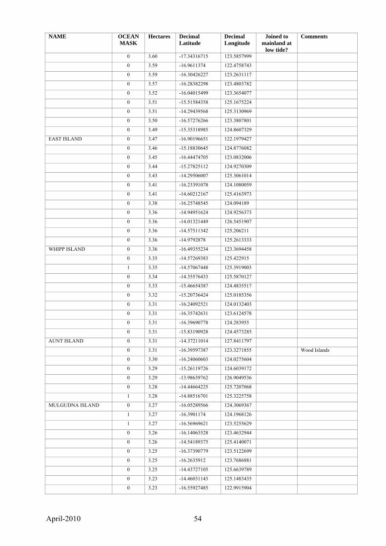
April-2010 54
NAME OCEAN MASK
Hectares Decimal Latitude
Decimal Longitude
Joined to mainland at
low tide?
Comments
0 3.60 -17.34316715 123.5857999
0 3.59 -16.9611374 122.4758743
0 3.59 -16.30426227 123.2631117
0 3.57 -16.28382298 123.4803782
0 3.52 -16.04015499 123.3654077
0 3.51 -15.51584358 125.1675224
0 3.51 -14.29439568 125.3130969
0 3.50 -16.57276266 123.3807801
0 3.49 -15.35318985 124.8607329
EAST ISLAND 0 3.47 -16.90196651 122.1979427
0 3.46 -15.18830645 124.8776082
0 3.45 -16.44474705 123.0832006
0 3.44 -15.27825112 124.9270309
0 3.43 -14.29506007 125.3061014
0 3.41 -16.23391078 124.1080059
0 3.41 -14.60212167 125.4163973
0 3.38 -16.25748545 124.094189
0 3.36 -14.94951624 124.9256373
0 3.36 -14.01321449 126.5451907
0 3.36 -14.57511342 125.206211
0 3.36 -14.9792878 125.2613333
WHIPP ISLAND 0 3.36 -16.49355234 123.3694458
0 3.35 -14.57269383 125.422915
1 3.35 -14.57067448 125.3919003
0 3.34 -14.35576433 125.5870127
0 3.33 -15.46654387 124.4835517
0 3.32 -15.20736424 125.0185356
0 3.31 -16.24092521 124.0132403
0 3.31 -16.35742631 123.6124578
0 3.31 -16.39690778 124.283955
0 3.31 -15.83190928 124.4573285
AUNT ISLAND 0 3.31 -14.37211014 127.8411797
0 3.31 -16.39597387 123.3271855 Wood Islands
0 3.30 -16.24060603 124.0275604
0 3.29 -15.26119726 124.6039172
0 3.29 -13.98639762 126.9049536
0 3.28 -14.44664225 125.7207068
1 3.28 -14.88516701 125.3225758
MULGUDNA ISLAND 0 3.27 -16.05289566 124.3069367
1 3.27 -16.3901174 124.1968126
1 3.27 -16.56969621 123.5255629
0 3.26 -16.14063528 123.4632944
0 3.26 -14.54189375 125.4140071
0 3.25 -16.37390779 123.5122699
0 3.25 -16.2635912 123.7686881
0 3.25 -14.43727105 125.6639789
0 3.23 -14.46031143 125.1483435
0 3.23 -16.55927485 122.9915904
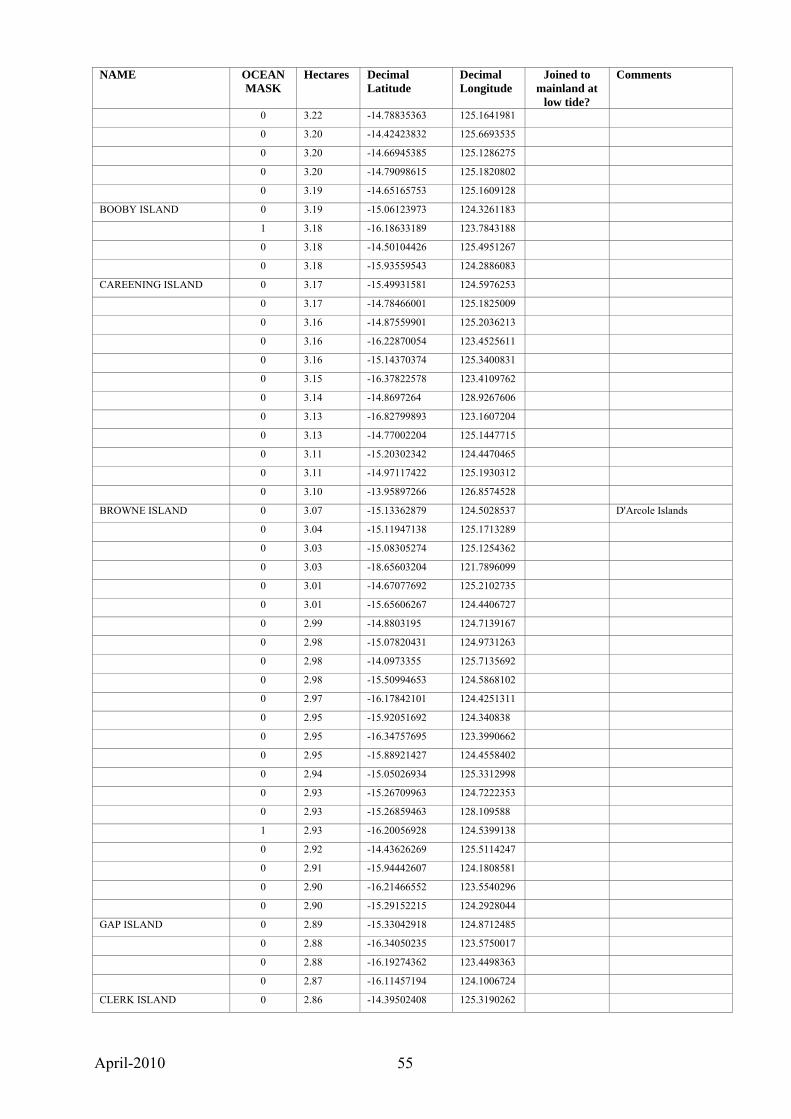
April-2010 55
NAME OCEAN MASK
Hectares Decimal Latitude
Decimal Longitude
Joined to mainland at
low tide?
Comments
0 3.22 -14.78835363 125.1641981
0 3.20 -14.42423832 125.6693535
0 3.20 -14.66945385 125.1286275
0 3.20 -14.79098615 125.1820802
0 3.19 -14.65165753 125.1609128
BOOBY ISLAND 0 3.19 -15.06123973 124.3261183
1 3.18 -16.18633189 123.7843188
0 3.18 -14.50104426 125.4951267
0 3.18 -15.93559543 124.2886083
CAREENING ISLAND 0 3.17 -15.49931581 124.5976253
0 3.17 -14.78466001 125.1825009
0 3.16 -14.87559901 125.2036213
0 3.16 -16.22870054 123.4525611
0 3.16 -15.14370374 125.3400831
0 3.15 -16.37822578 123.4109762
0 3.14 -14.8697264 128.9267606
0 3.13 -16.82799893 123.1607204
0 3.13 -14.77002204 125.1447715
0 3.11 -15.20302342 124.4470465
0 3.11 -14.97117422 125.1930312
0 3.10 -13.95897266 126.8574528
BROWNE ISLAND 0 3.07 -15.13362879 124.5028537 D'Arcole Islands
0 3.04 -15.11947138 125.1713289
0 3.03 -15.08305274 125.1254362
0 3.03 -18.65603204 121.7896099
0 3.01 -14.67077692 125.2102735
0 3.01 -15.65606267 124.4406727
0 2.99 -14.8803195 124.7139167
0 2.98 -15.07820431 124.9731263
0 2.98 -14.0973355 125.7135692
0 2.98 -15.50994653 124.5868102
0 2.97 -16.17842101 124.4251311
0 2.95 -15.92051692 124.340838
0 2.95 -16.34757695 123.3990662
0 2.95 -15.88921427 124.4558402
0 2.94 -15.05026934 125.3312998
0 2.93 -15.26709963 124.7222353
0 2.93 -15.26859463 128.109588
1 2.93 -16.20056928 124.5399138
0 2.92 -14.43626269 125.5114247
0 2.91 -15.94442607 124.1808581
0 2.90 -16.21466552 123.5540296
0 2.90 -15.29152215 124.2928044
GAP ISLAND 0 2.89 -15.33042918 124.8712485
0 2.88 -16.34050235 123.5750017
0 2.88 -16.19274362 123.4498363
0 2.87 -16.11457194 124.1006724
CLERK ISLAND 0 2.86 -14.39502408 125.3190262
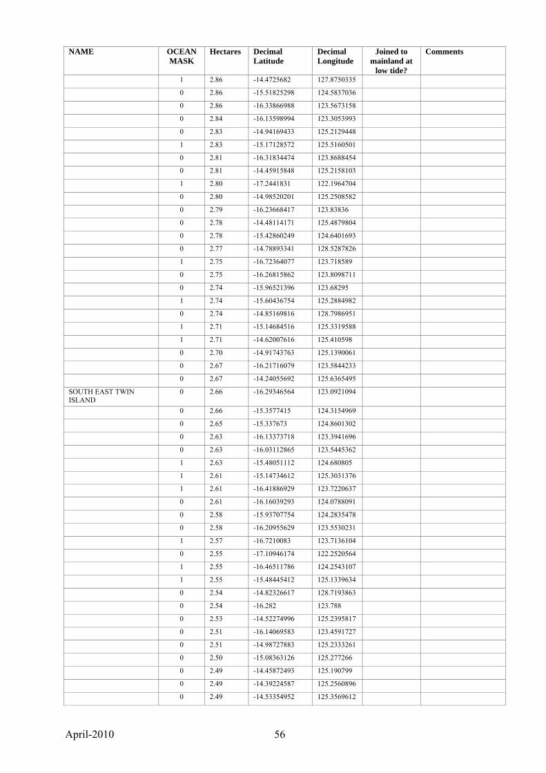
April-2010 56
NAME OCEAN MASK
Hectares Decimal Latitude
Decimal Longitude
Joined to mainland at
low tide?
Comments
1 2.86 -14.4725682 127.8750335
0 2.86 -15.51825298 124.5837036
0 2.86 -16.33866988 123.5673158
0 2.84 -16.13598994 123.3053993
0 2.83 -14.94169433 125.2129448
1 2.83 -15.17128572 125.5160501
0 2.81 -16.31834474 123.8688454
0 2.81 -14.45915848 125.2158103
1 2.80 -17.2441831 122.1964704
0 2.80 -14.98520201 125.2508582
0 2.79 -16.23668417 123.83836
0 2.78 -14.48114171 125.4879804
0 2.78 -15.42860249 124.6401693
0 2.77 -14.78893341 128.5287826
1 2.75 -16.72364077 123.718589
0 2.75 -16.26815862 123.8098711
0 2.74 -15.96521396 123.68295
1 2.74 -15.60436754 125.2884982
0 2.74 -14.85169816 128.7986951
1 2.71 -15.14684516 125.3319588
1 2.71 -14.62007616 125.410598
0 2.70 -14.91743763 125.1390061
0 2.67 -16.21716079 123.5844233
0 2.67 -14.24055692 125.6365495
SOUTH EAST TWIN ISLAND
0 2.66 -16.29346564 123.0921094
0 2.66 -15.3577415 124.3154969
0 2.65 -15.337673 124.8601302
0 2.63 -16.13373718 123.3941696
0 2.63 -16.03112865 123.5445362
1 2.63 -15.48051112 124.680805
1 2.61 -15.14734612 125.3031376
1 2.61 -16.41886929 123.7220637
0 2.61 -16.16039293 124.0788091
0 2.58 -15.93707754 124.2835478
0 2.58 -16.20955629 123.5530231
1 2.57 -16.7210083 123.7136104
0 2.55 -17.10946174 122.2520564
1 2.55 -16.46511786 124.2543107
1 2.55 -15.48445412 125.1339634
0 2.54 -14.82326617 128.7193863
0 2.54 -16.282 123.788
0 2.53 -14.52274996 125.2395817
0 2.51 -16.14069583 123.4591727
0 2.51 -14.98727883 125.2333261
0 2.50 -15.08363126 125.277266
0 2.49 -14.45872493 125.190799
0 2.49 -14.39224587 125.2560896
0 2.49 -14.53354952 125.3569612

April-2010 57
NAME OCEAN MASK
Hectares Decimal Latitude
Decimal Longitude
Joined to mainland at
low tide?
Comments
1 2.48 -16.37044159 124.1674697
0 2.47 -16.31460129 123.878654
0 2.46 -16.27012842 123.5701528
0 2.46 -16.27409321 124.084002
1 2.46 -14.55988227 125.5987375
LIVINGSTONE ISLAND 0 2.44 -16.44136382 123.1107732
LONGITUDE ISLAND 0 2.44 -16.05860134 123.4021711
0 2.44 -16.25353453 123.8091109
0 2.44 -14.62772813 125.2221207
0 2.43 -13.83795834 127.0490731
0 2.43 -13.97031809 126.8779695
0 2.43 -15.27436064 124.8629478
0 2.42 -16.49767486 123.5751066
0 2.42 -16.18226023 124.432108
1 2.42 -15.60325291 125.2845837
0 2.41 -14.11138426 125.7010965
0 2.39 -14.4650672 125.2101202
0 2.39 -14.38582642 125.6846708
0 2.38 -16.25813625 123.8398821
0 2.38 -14.37610099 125.4147442
0 2.38 -16.16185489 123.3284613
0 2.37 -15.12019874 125.1960763
0 2.37 -16.55904773 122.8055903
HELBY ISLAND 0 2.37 -15.23284208 128.1099822
1 2.36 -15.52463546 124.6294646
0 2.36 -14.39959952 125.6639517
0 2.35 -16.34280093 123.4101118
0 2.35 -14.54255734 125.2017866
0 2.34 -15.35146241 124.3284953
0 2.34 -16.03158197 123.5601976
0 2.34 -16.07849344 124.0634519
0 2.33 -13.81033196 127.020411
0 2.32 -14.18089662 125.6780164
0 2.32 -14.46060483 125.6916435
0 2.32 -16.30716115 123.2676456
0 2.32 -16.30728833 124.1995352
0 2.31 -16.44466552 123.0882046
0 2.30 -16.18677559 123.8176615
0 2.30 -16.27770427 123.8131977
PACK ISLAND 0 2.30 -16.51295962 123.4106096
0 2.29 -16.3444028 123.4217459
0 2.29 -14.63948922 125.1558142
0 2.29 -16.38158757 123.4963978
0 2.29 -14.9650537 124.8155659
0 2.28 -14.21112265 126.0308109
0 2.28 -14.46320575 125.1930368
0 2.28 -14.63106803 125.0930859
0 2.28 -15.19467879 124.7004351

April-2010 58
NAME OCEAN MASK
Hectares Decimal Latitude
Decimal Longitude
Joined to mainland at
low tide?
Comments
0 2.28 -16.25386658 124.0828546
0 2.28 -14.85630943 128.7953937
0 2.26 -16.15293749 123.3209757
0 2.25 -14.50465658 125.3767578
0 2.24 -14.99582116 124.8490141
0 2.23 -15.39562232 124.9599865
0 2.23 -14.8628706 128.8202666
0 2.23 -14.57319222 125.1338411
0 2.22 -14.99857126 125.2816725
0 2.21 -15.23914009 124.5265439
0 2.21 -15.35544699 124.3649506
0 2.21 -16.25431923 124.1172151
0 2.20 -14.426521 125.7504018
0 2.20 -15.30203404 124.364726
0 2.19 -13.9427091 126.7097596
1 2.19 -15.52575702 125.1953792
0 2.19 -14.46480177 125.7765966
0 2.18 -15.35468645 124.4897404
0 2.17 -14.77237646 128.7825126
0 2.16 -13.98120799 126.878665
0 2.16 -16.55937668 123.35225
0 2.16 -16.16715003 123.4637812
0 2.15 -16.44151936 123.3533171
0 2.15 -16.13218601 123.4610864
0 2.14 -14.54242427 125.2001697
0 2.14 -16.15520091 123.4305117
0 2.13 -14.86338341 128.8170904
0 2.13 -16.2403832 124.0368658
0 2.11 -14.63566945 125.0950674
0 2.10 -14.46477431 125.1909183
TANNER ISLAND 0 2.08 -16.09409538 123.5296232
0 2.07 -14.46801746 125.1865653
0 2.07 -14.56656457 125.3876421
0 2.07 -13.90567845 126.5893089
0 2.07 -16.10546771 124.0913305
0 2.06 -16.49783476 123.4830123
1 2.04 -16.40763255 123.6866085
0 2.04 -14.67322033 125.1271872
0 2.04 -14.47431479 125.0086538
1 2.02 -16.09658232 124.603235
0 2.02 -14.33228231 125.3798714
0 2.01 -14.56999262 125.3237781
0 2.01 -16.1568936 123.5315087
0 2.00 -14.21610461 126.5864326
0 2.00 -16.39055279 123.13069
0 2.00 -14.67303898 125.1431989
0 2.00 -14.17895934 127.6495358
0 2.00 -17.10720477 122.2477571
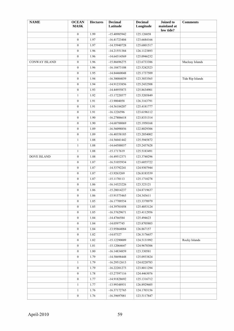
April-2010 59
NAME OCEAN MASK
Hectares Decimal Latitude
Decimal Longitude
Joined to mainland at
low tide?
Comments
0 1.99 -15.48985942 125.126858
0 1.97 -16.41723404 123.6684166
0 1.97 -14.35940728 125.6801517
0 1.96 -14.21551384 126.1123893
0 1.96 -14.64314569 125.0946232
CONWAY ISLAND 0 1.96 -15.86696275 123.6733386 Macleay Islands
0 1.96 -16.18473108 123.5242523
0 1.95 -14.84460048 125.1737509
0 1.94 -16.30084039 123.3033565 Tide Rip Islands
0 1.94 -14.91233856 125.2432508
0 1.93 -14.44955873 125.8634901
1 1.92 -15.17220577 125.5205849
0 1.91 -13.9004058 126.3163791
0 1.91 -14.56184207 125.4181777
0 1.91 -16.1226596 123.6196112
0 1.90 -16.27806618 123.8331314
0 1.90 -14.68788069 125.1950168
0 1.89 -16.56098856 122.8029306
0 1.89 -16.40358185 123.2054002
1 1.88 -14.56041442 125.5945872
1 1.88 -14.64588037 125.2437628
1 1.88 -15.1717619 125.5183491
DOVE ISLAND 0 1.88 -16.49512371 123.3740296
0 1.87 -16.51055934 123.6055722
0 1.87 -14.53792241 124.9307944
0 1.87 -13.9263269 126.8183539
0 1.87 -15.1170113 125.1710278
0 1.86 -16.14323226 123.323121
0 1.86 -15.28014237 124.8719637
0 1.86 -15.91575465 124.343611
0 1.85 -16.17709554 123.3378979
0 1.85 -14.39701058 125.4053124
0 1.85 -16.37629671 123.4112956
0 1.84 -14.4766584 125.494623
0 1.84 -14.0597745 125.8705803
0 1.84 -13.95864084 126.867157
0 1.82 -14.07327 126.3176657
0 1.82 -15.12290009 124.5131992 Rocky Islands
0 1.81 -15.12064647 124.9670306
0 1.80 -16.14834859 123.330581
0 1.79 -14.58698448 125.0933824
1 1.79 -16.29512613 124.0220783
0 1.79 -16.22201273 123.8011294
0 1.78 -15.27597116 124.4463076
0 1.77 -14.91828692 125.1316712
1 1.77 -13.99348931 126.8929605
1 1.76 -16.37172765 124.1703156
0 1.76 -16.39697081 123.5117847
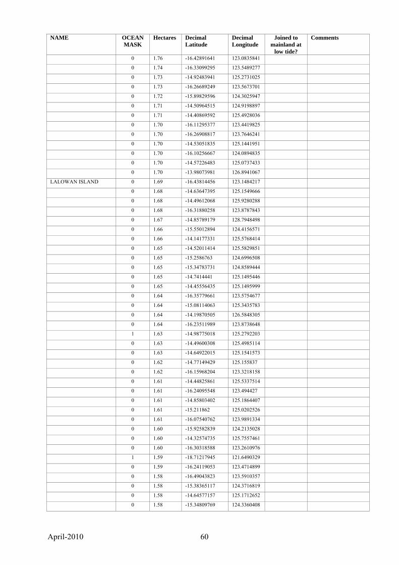
April-2010 60
NAME OCEAN MASK
Hectares Decimal Latitude
Decimal Longitude
Joined to mainland at
low tide?
Comments
0 1.76 -16.42891641 123.0835841
0 1.74 -16.33099295 123.5489277
0 1.73 -14.92483941 125.2731025
0 1.73 -16.26689249 123.5673701
0 1.72 -15.89829596 124.3025947
0 1.71 -14.50964515 124.9198897
0 1.71 -14.40869592 125.4928036
0 1.70 -16.11295377 123.4419825
0 1.70 -16.26908817 123.7646241
0 1.70 -14.53051835 125.1441951
0 1.70 -16.10256667 124.0894835
0 1.70 -14.57226483 125.0737433
0 1.70 -13.98073981 126.8941067
LALOWAN ISLAND 0 1.69 -16.43814456 123.1484217
0 1.68 -14.63647395 125.1549666
0 1.68 -14.49612068 125.9280288
0 1.68 -16.31880258 123.8787843
0 1.67 -14.85789179 128.7948498
0 1.66 -15.55012894 124.4156571
0 1.66 -14.14177331 125.5768414
0 1.65 -14.52011414 125.5829851
0 1.65 -15.2586763 124.6996508
0 1.65 -15.34783731 124.8589444
0 1.65 -14.7414441 125.1495446
0 1.65 -14.45556435 125.1495999
0 1.64 -16.35779661 123.5754677
0 1.64 -15.08114063 125.3435783
0 1.64 -14.19870505 126.5848305
0 1.64 -16.23511989 123.8738648
1 1.63 -14.98775018 125.2792203
0 1.63 -14.49600308 125.4985114
0 1.63 -14.64922015 125.1541573
0 1.62 -14.77149429 125.155837
0 1.62 -16.15968204 123.3218158
0 1.61 -14.44825861 125.5337514
0 1.61 -16.24095548 123.494427
0 1.61 -14.85803402 125.1864407
0 1.61 -15.211862 125.0202526
0 1.61 -16.07540762 123.9891334
0 1.60 -15.92582839 124.2135028
0 1.60 -14.32574735 125.7557461
0 1.60 -16.30318588 123.2610976
1 1.59 -18.71217945 121.6490329
0 1.59 -16.24119053 123.4714899
0 1.58 -16.49043823 123.5910357
0 1.58 -15.38365117 124.3716819
0 1.58 -14.64577157 125.1712652
0 1.58 -15.34809769 124.3360408
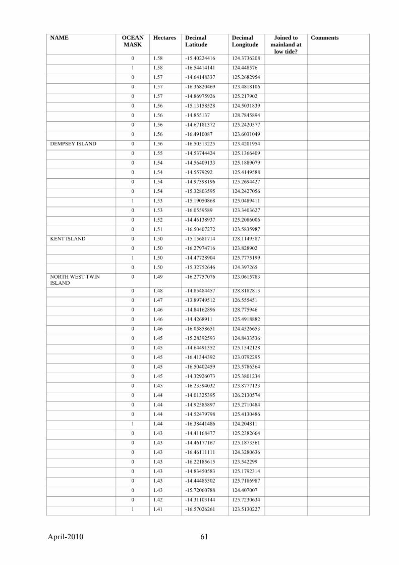
April-2010 61
NAME OCEAN MASK
Hectares Decimal Latitude
Decimal Longitude
Joined to mainland at
low tide?
Comments
0 1.58 -15.40224416 124.3736208
1 1.58 -16.54414141 124.448576
0 1.57 -14.64148337 125.2682954
0 1.57 -16.36820469 123.4818106
0 1.57 -14.86975926 125.217902
0 1.56 -15.13158528 124.5031839
0 1.56 -14.855137 128.7845894
0 1.56 -14.67181372 125.2420577
0 1.56 -16.4910087 123.6031049
DEMPSEY ISLAND 0 1.56 -16.50513225 123.4201954
0 1.55 -14.53744424 125.1366409
0 1.54 -14.56409133 125.1889079
0 1.54 -14.5579292 125.4149588
0 1.54 -14.97398196 125.2694427
0 1.54 -15.32803595 124.2427056
1 1.53 -15.19050868 125.0489411
0 1.53 -16.0559589 123.3403627
0 1.52 -14.46138937 125.2086006
0 1.51 -16.50407272 123.5835987
KENT ISLAND 0 1.50 -15.15681714 128.1149587
0 1.50 -16.27974716 123.828902
1 1.50 -14.47728904 125.7775199
0 1.50 -15.32752646 124.397265
NORTH WEST TWIN ISLAND
0 1.49 -16.27757076 123.0615783
0 1.48 -14.85484457 128.8182813
0 1.47 -13.89749512 126.555451
0 1.46 -14.84162896 128.775946
0 1.46 -14.4268911 125.4918882
0 1.46 -16.05858651 124.4526653
0 1.45 -15.28392593 124.8433536
0 1.45 -14.64491352 125.1542128
0 1.45 -16.41344392 123.0792295
0 1.45 -16.50402459 123.5786364
0 1.45 -14.32926073 125.3801234
0 1.45 -16.23594032 123.8777123
0 1.44 -14.01325395 126.2130574
0 1.44 -14.92585897 125.2710484
0 1.44 -14.52479798 125.4130486
1 1.44 -16.38441486 124.204811
0 1.43 -14.41168477 125.2382664
0 1.43 -14.46177167 125.1873361
0 1.43 -16.46111111 124.3280636
0 1.43 -16.22185615 123.542299
0 1.43 -14.83450583 125.1792314
0 1.43 -14.44485302 125.7186987
0 1.43 -15.72060788 124.407007
0 1.42 -14.31103144 125.7230634
1 1.41 -16.57026261 123.5130227
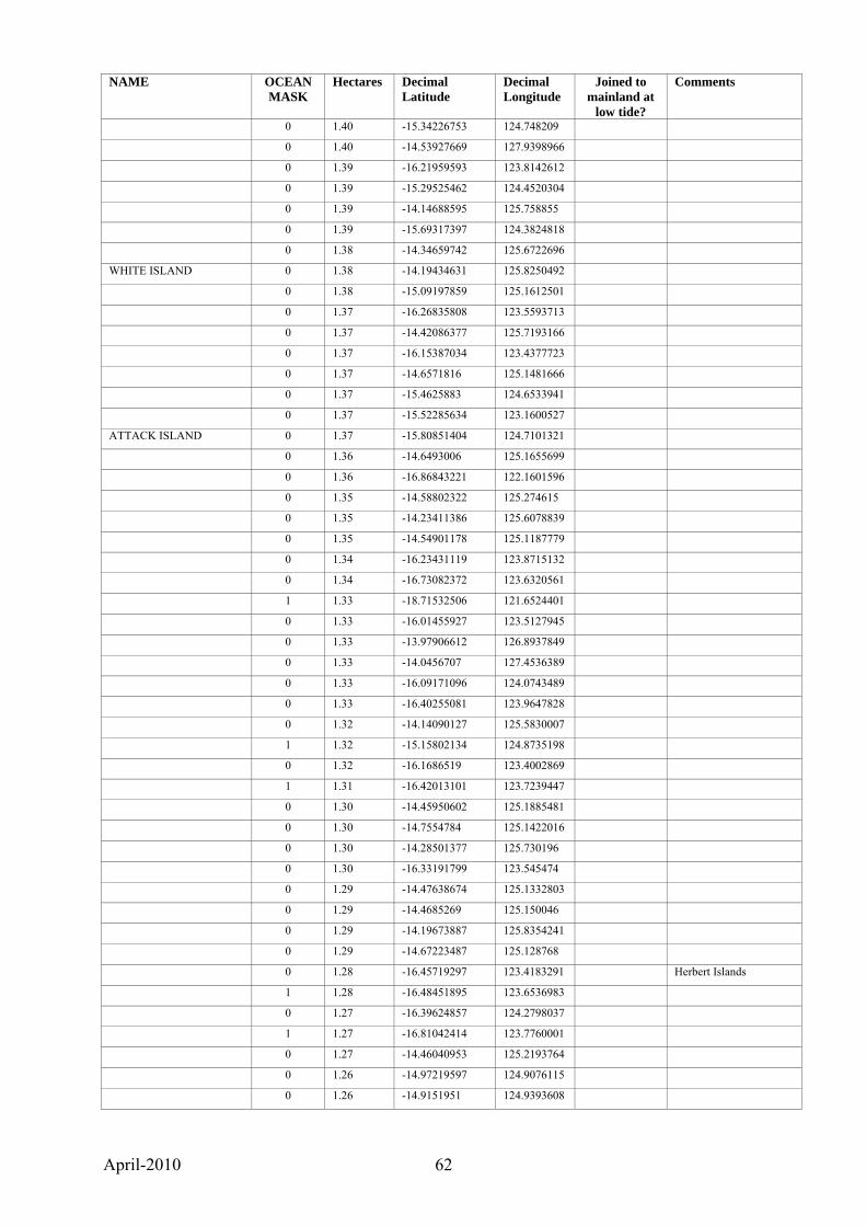
April-2010 62
NAME OCEAN MASK
Hectares Decimal Latitude
Decimal Longitude
Joined to mainland at
low tide?
Comments
0 1.40 -15.34226753 124.748209
0 1.40 -14.53927669 127.9398966
0 1.39 -16.21959593 123.8142612
0 1.39 -15.29525462 124.4520304
0 1.39 -14.14688595 125.758855
0 1.39 -15.69317397 124.3824818
0 1.38 -14.34659742 125.6722696
WHITE ISLAND 0 1.38 -14.19434631 125.8250492
0 1.38 -15.09197859 125.1612501
0 1.37 -16.26835808 123.5593713
0 1.37 -14.42086377 125.7193166
0 1.37 -16.15387034 123.4377723
0 1.37 -14.6571816 125.1481666
0 1.37 -15.4625883 124.6533941
0 1.37 -15.52285634 123.1600527
ATTACK ISLAND 0 1.37 -15.80851404 124.7101321
0 1.36 -14.6493006 125.1655699
0 1.36 -16.86843221 122.1601596
0 1.35 -14.58802322 125.274615
0 1.35 -14.23411386 125.6078839
0 1.35 -14.54901178 125.1187779
0 1.34 -16.23431119 123.8715132
0 1.34 -16.73082372 123.6320561
1 1.33 -18.71532506 121.6524401
0 1.33 -16.01455927 123.5127945
0 1.33 -13.97906612 126.8937849
0 1.33 -14.0456707 127.4536389
0 1.33 -16.09171096 124.0743489
0 1.33 -16.40255081 123.9647828
0 1.32 -14.14090127 125.5830007
1 1.32 -15.15802134 124.8735198
0 1.32 -16.1686519 123.4002869
1 1.31 -16.42013101 123.7239447
0 1.30 -14.45950602 125.1885481
0 1.30 -14.7554784 125.1422016
0 1.30 -14.28501377 125.730196
0 1.30 -16.33191799 123.545474
0 1.29 -14.47638674 125.1332803
0 1.29 -14.4685269 125.150046
0 1.29 -14.19673887 125.8354241
0 1.29 -14.67223487 125.128768
0 1.28 -16.45719297 123.4183291 Herbert Islands
1 1.28 -16.48451895 123.6536983
0 1.27 -16.39624857 124.2798037
1 1.27 -16.81042414 123.7760001
0 1.27 -14.46040953 125.2193764
0 1.26 -14.97219597 124.9076115
0 1.26 -14.9151951 124.9393608
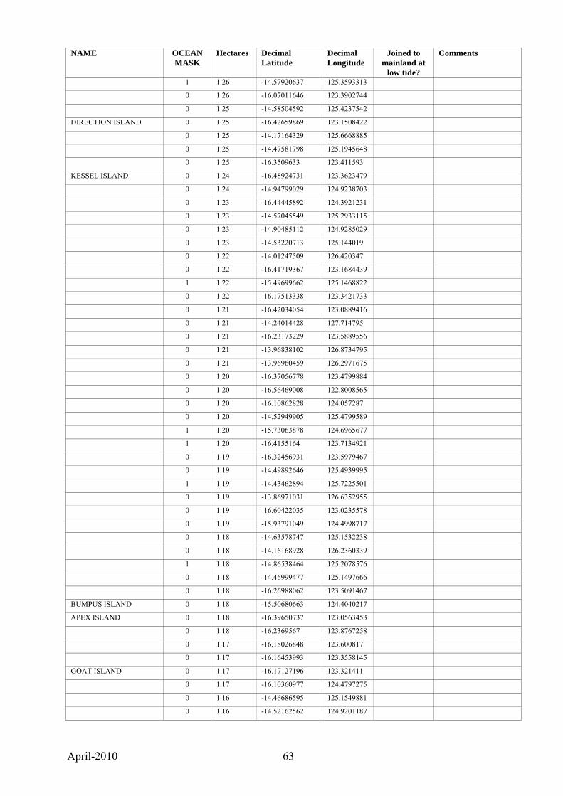
April-2010 63
NAME OCEAN MASK
Hectares Decimal Latitude
Decimal Longitude
Joined to mainland at
low tide?
Comments
1 1.26 -14.57920637 125.3593313
0 1.26 -16.07011646 123.3902744
0 1.25 -14.58504592 125.4237542
DIRECTION ISLAND 0 1.25 -16.42659869 123.1508422
0 1.25 -14.17164329 125.6668885
0 1.25 -14.47581798 125.1945648
0 1.25 -16.3509633 123.411593
KESSEL ISLAND 0 1.24 -16.48924731 123.3623479
0 1.24 -14.94799029 124.9238703
0 1.23 -16.44445892 124.3921231
0 1.23 -14.57045549 125.2933115
0 1.23 -14.90485112 124.9285029
0 1.23 -14.53220713 125.144019
0 1.22 -14.01247509 126.420347
0 1.22 -16.41719367 123.1684439
1 1.22 -15.49699662 125.1468822
0 1.22 -16.17513338 123.3421733
0 1.21 -16.42034054 123.0889416
0 1.21 -14.24014428 127.714795
0 1.21 -16.23173229 123.5889556
0 1.21 -13.96838102 126.8734795
0 1.21 -13.96960459 126.2971675
0 1.20 -16.37056778 123.4799884
0 1.20 -16.56469008 122.8008565
0 1.20 -16.10862828 124.057287
0 1.20 -14.52949905 125.4799589
1 1.20 -15.73063878 124.6965677
1 1.20 -16.4155164 123.7134921
0 1.19 -16.32456931 123.5979467
0 1.19 -14.49892646 125.4939995
1 1.19 -14.43462894 125.7225501
0 1.19 -13.86971031 126.6352955
0 1.19 -16.60422035 123.0235578
0 1.19 -15.93791049 124.4998717
0 1.18 -14.63578747 125.1532238
0 1.18 -14.16168928 126.2360339
1 1.18 -14.86538464 125.2078576
0 1.18 -14.46999477 125.1497666
0 1.18 -16.26988062 123.5091467
BUMPUS ISLAND 0 1.18 -15.50680663 124.4040217
APEX ISLAND 0 1.18 -16.39650737 123.0563453
0 1.18 -16.2369567 123.8767258
0 1.17 -16.18026848 123.600817
0 1.17 -16.16453993 123.3558145
GOAT ISLAND 0 1.17 -16.17127196 123.321411
0 1.17 -16.10360977 124.4797275
0 1.16 -14.46686595 125.1549881
0 1.16 -14.52162562 124.9201187
April-2010 64
NAME OCEAN MASK
Hectares Decimal Latitude
Decimal Longitude
Joined to mainland at
low tide?
Comments
0 1.16 -16.59615796 123.5160025
0 1.16 -15.21047045 124.7008465
0 1.16 -17.23752208 122.1846804
0 1.16 -14.47401056 125.1542072
0 1.16 -14.10332192 125.6915038
0 1.15 -15.22048196 124.734374
0 1.15 -15.22739253 124.5388483
0 1.15 -16.15718994 123.4205436
0 1.15 -16.33134415 124.1949547
1 1.15 -16.84145493 122.5703087
0 1.15 -14.47121455 125.1941488
0 1.15 -16.26545819 123.765379
0 1.15 -14.06699697 127.5185896
0 1.14 -14.44860585 125.7172143
0 1.14 -14.65115041 125.6478779
0 1.14 -16.26997401 123.7745282
0 1.14 -16.2547683 124.0879296
0 1.13 -14.48974792 125.4969582
0 1.13 -14.62200076 125.0971836
0 1.13 -14.22927276 126.2969185
0 1.13 -16.27837269 123.4150643
0 1.12 -16.19516303 123.9755543
0 1.12 -16.25146605 123.9877726
0 1.12 -14.86940705 125.2804116
0 1.11 -16.03365936 123.5592165
0 1.11 -14.48506813 125.3643698
0 1.11 -15.4276013 124.6381617
0 1.10 -16.40780158 123.1420708
0 1.10 -14.87233312 128.952727
0 1.09 -16.09793497 124.0871159
KID ISLAND 0 1.09 -15.66475234 124.4012808
0 1.09 -16.17450622 123.4192344
1 1.09 -15.47412237 125.1014719
1 1.09 -14.64051041 125.4484752
0 1.09 -16.38615007 123.1375249
0 1.09 -14.65061111 125.1552746
0 1.09 -14.64763835 125.0942996
0 1.09 -14.48925176 126.0418254
0 1.08 -14.08452105 127.512605
0 1.08 -15.06192992 128.1468747
0 1.08 -16.24733384 123.8373875
0 1.08 -14.64440015 125.1143525
0 1.07 -16.42482627 123.0973672
0 1.07 -16.22343456 123.444222
0 1.07 -14.91574142 125.2847014
0 1.06 -15.00921332 124.5966591
0 1.06 -15.30839806 124.8151571
0 1.06 -16.43666526 123.1291658

April-2010 65
NAME OCEAN MASK
Hectares Decimal Latitude
Decimal Longitude
Joined to mainland at
low tide?
Comments
0 1.06 -14.6235076 125.168696
0 1.06 -14.96581176 125.2300273
0 1.06 -14.41538824 125.6628716
0 1.06 -14.19437595 125.835185
0 1.05 -14.48408664 125.4965934
0 1.05 -16.23256707 123.5890707
0 1.04 -14.3537622 125.7195965
1 1.04 -14.50934617 125.3595057
0 1.04 -15.30366119 124.8238095
0 1.04 -14.47876167 125.1327579
0 1.04 -14.41858267 124.9749263
0 1.04 -14.87266893 128.9323119
0 1.03 -16.15043328 123.347753
0 1.03 -16.99954416 122.3611636
0 1.02 -14.21387599 126.5843172
0 1.02 -15.91644107 124.5814191
0 1.02 -16.21527451 123.5571935
0 1.02 -14.31760104 125.739358
0 1.02 -16.69129499 123.1334175
0 1.02 -16.36408123 123.4917033
0 1.01 -14.51761039 125.4886371
0 1.01 -14.63919143 125.265566
0 1.01 -15.14169609 128.1207045
0 1.01 -14.5697685 125.423991
0 1.01 -14.87622411 128.9813507
0 1.00 -16.11725233 123.4467434
0 1.00 -16.38068048 123.1339018
0 0.99 -16.17227591 124.4151191
1 0.99 -14.37698521 127.7555652
0 0.99 -16.42704047 123.3608905
0 0.99 -14.22251068 125.7969215
0 0.99 -14.48760059 124.9656109
0 0.99 -16.61714999 123.5326947
0 0.99 -14.37839368 125.6843112
0 0.99 -16.83308489 123.1610764
0 0.98 -16.21368006 123.6095176
0 0.98 -14.979487 124.55555
0 0.98 -13.94851267 126.8178255
1 0.98 -16.2922377 123.5571196
1 0.98 -14.63791924 125.2695801
UNCLE ISLAND 0 0.98 -14.3730315 127.8383817
0 0.97 -14.46461743 125.1534994
0 0.96 -14.49428701 125.3775452
0 0.96 -16.38887894 123.3081832
0 0.96 -14.13972322 125.5751928
0 0.96 -16.16999107 123.5677535
0 0.96 -13.89701025 126.1021455
0 0.96 -16.12163985 123.372516

April-2010 66
NAME OCEAN MASK
Hectares Decimal Latitude
Decimal Longitude
Joined to mainland at
low tide?
Comments
0 0.95 -15.47740436 124.6738203
0 0.95 -14.52654885 125.3268817
0 0.95 -14.47052711 125.1430689
0 0.95 -16.25734797 123.4626194
0 0.95 -14.35714788 125.678042
0 0.94 -18.80553466 121.6387812
1 0.94 -16.20157938 123.7919776
1 0.94 -16.31309649 123.8856183
1 0.94 -16.20760402 123.5701935
0 0.94 -16.21395348 123.6162938
0 0.93 -16.12828431 123.2854715
0 0.93 -14.63313552 125.4357064
1 0.93 -16.25644722 123.7443845
0 0.93 -14.17469838 126.1477236
0 0.93 -16.40586264 123.2029931
1 0.93 -16.41180289 124.4476432
0 0.93 -14.51547606 125.9583284
0 0.93 -15.33221124 124.8732373
1 0.92 -14.85252887 125.2100043
1 0.92 -15.23024775 125.3600361
0 0.92 -14.77762055 128.5533033
0 0.92 -13.9680559 126.2983302
0 0.92 -14.42190399 125.5125794
0 0.92 -16.44469844 123.3522959
0 0.92 -16.19003554 123.4763779
BIRD ISLAND 0 0.91 -14.08392792 125.7131667
0 0.91 -16.08168045 123.4003661
0 0.91 -14.0616716 125.8721769
0 0.91 -15.32326926 124.2101436
0 0.91 -16.15015402 123.6897898
0 0.90 -15.3362122 124.3112105
0 0.90 -16.44870605 123.3502049
0 0.90 -16.03461893 123.5570118
0 0.90 -14.57107545 125.3773587
0 0.89 -16.46156915 123.4322712
0 0.89 -16.2373997 124.1022992
REES ISLAND 0 0.89 -16.38602011 123.106916
0 0.89 -14.63585202 125.2233479
0 0.89 -14.85233545 128.7820186
0 0.89 -14.19985674 125.643931
0 0.88 -14.6423866 125.0968193
0 0.88 -15.85315955 124.4518839
0 0.88 -16.12345089 123.4156891
0 0.88 -16.2263421 123.4797966
0 0.88 -16.42065822 123.1967633
0 0.88 -16.23208826 124.1032865
0 0.88 -13.88196463 126.5973897
0 0.88 -14.49207021 124.9671383

April-2010 67
NAME OCEAN MASK
Hectares Decimal Latitude
Decimal Longitude
Joined to mainland at
low tide?
Comments
0 0.87 -14.22413066 126.0165213
0 0.87 -16.50283071 123.3876862
0 0.87 -16.50148804 123.4460801
0 0.87 -16.43796754 123.3454865
0 0.87 -16.24070472 123.9972706
0 0.87 -16.56235923 122.8018865
0 0.86 -16.03567527 123.2950381
0 0.86 -15.0241945 125.1691943
0 0.86 -16.2445448 124.1339578
0 0.86 -16.53984854 123.3562488
0 0.86 -14.08864064 125.7033599
0 0.86 -15.43388951 124.6681866
1 0.85 -16.39649898 124.1972861
0 0.85 -14.38683615 125.4177506
0 0.85 -16.20289585 123.5330265
1 0.85 -16.32083556 123.8087908
0 0.85 -15.51945905 123.1580176
0 0.85 -14.95410592 124.6736446
0 0.85 -15.90650808 124.5993636
0 0.84 -15.88092875 124.6270194
0 0.84 -16.13250812 123.288235
0 0.84 -14.66605245 125.1287003
0 0.84 -15.12191738 125.1964772
0 0.83 -15.29955337 124.4102986
0 0.83 -14.31390777 125.7245801
0 0.83 -16.14296071 123.3143493
0 0.83 -15.32388346 123.5283814
1 0.83 -16.40777167 124.4708292
0 0.83 -14.81731994 128.7203413
0 0.83 -16.55086792 122.9865862
0 0.82 -14.64092399 125.1588267
0 0.82 -14.56737267 125.0935217
0 0.82 -16.50190433 123.4482981
0 0.82 -16.39239374 123.1431608
0 0.82 -16.5041306 124.4645325
0 0.82 -14.49559276 125.4968356
0 0.81 -16.63927397 123.0433131
0 0.81 -14.84156308 125.168133
1 0.81 -16.23150308 123.621036
1 0.81 -18.7196411 121.6532231
0 0.80 -14.17658275 126.2284981
0 0.80 -14.99153357 125.2744626
0 0.80 -14.38383454 124.9742993
0 0.80 -16.44870196 123.5470879
SAVILLE ISLAND 0 0.80 -15.14843136 128.1026522
0 0.80 -16.39810799 123.9652076
1 0.80 -16.20819527 123.786326
0 0.79 -13.98388093 126.3491027
April-2010 68
NAME OCEAN MASK
Hectares Decimal Latitude
Decimal Longitude
Joined to mainland at
low tide?
Comments
0 0.79 -14.60396222 125.4153035
0 0.79 -14.50845848 125.1203622
0 0.79 -16.34752393 123.9700572
0 0.79 -13.97980158 126.8735024
0 0.79 -15.42417686 124.6680038
0 0.79 -16.47146029 123.4434994
0 0.79 -14.17785314 126.1479564
0 0.79 -16.19559094 123.4415051
0 0.79 -14.38457076 125.6800456
0 0.79 -16.5402149 123.3553457
1 0.78 -15.22297026 124.867752
0 0.78 -16.1528194 123.4674195
0 0.78 -14.31501171 125.7242253
1 0.78 -14.62865653 125.4496296
0 0.78 -16.36174964 123.3556655
0 0.78 -15.08927417 125.2400371
0 0.78 -16.28015765 123.4409931
1 0.78 -16.18619892 123.7836045
0 0.78 -16.36484016 123.4818386
0 0.78 -14.64037593 125.0913011
0 0.78 -16.32959756 124.1952931
1 0.77 -15.46170366 125.1087839
0 0.77 -15.22899998 124.3986333
0 0.77 -14.21446814 126.1305183
0 0.77 -16.0492616 123.4230901
0 0.76 -16.16558179 123.5932307
0 0.76 -14.64854378 125.2627839
0 0.76 -16.13608001 123.3286136
0 0.76 -16.5983619 123.5170534
0 0.76 -16.45847515 123.3407148 Wybron Islands
0 0.76 -16.23360726 123.8380375
0 0.75 -15.02900028 125.2576838
0 0.75 -15.72592115 124.3951118
0 0.75 -14.4571303 125.5088957
0 0.75 -14.06958038 125.7723777
0 0.75 -16.45472327 124.3538748
0 0.75 -16.59233498 122.7700245
0 0.75 -16.49250138 123.5825116
0 0.75 -14.47939636 125.1308585
0 0.75 -13.98567986 126.8831297
0 0.74 -16.3175337 123.3213115
0 0.74 -14.0239184 126.11657
0 0.74 -16.41692077 124.3283542
0 0.74 -16.23188719 123.8736291
0 0.74 -14.91765014 125.1523345
HUNT ISLAND 0 0.74 -16.39994433 123.2267526
1 0.74 -14.38693003 127.7504071
0 0.74 -14.48513405 125.3702303

April-2010 69
NAME OCEAN MASK
Hectares Decimal Latitude
Decimal Longitude
Joined to mainland at
low tide?
Comments
0 0.74 -16.23863648 124.3829788
0 0.73 -14.46801665 125.1560608
0 0.73 -14.32578185 125.7268208
0 0.73 -14.50311749 127.9159642
0 0.73 -17.23535252 122.1996604
0 0.73 -14.65141276 125.1628873
0 0.73 -14.93613873 124.658876
0 0.72 -16.44509074 123.112268
0 0.72 -16.29590171 124.3890644
0 0.72 -14.56484972 125.3899555
0 0.72 -16.28019044 123.4653748
0 0.72 -16.13521275 123.442932
1 0.72 -16.19969167 123.7960474
0 0.72 -16.16320991 123.6400061
0 0.72 -15.23467705 124.3692594
0 0.72 -14.91703131 125.2991501
0 0.72 -14.35653481 126.0622759
0 0.71 -14.78383031 128.5663835
1 0.71 -14.87030164 125.2726275
0 0.71 -16.3454738 123.8934034
0 0.71 -16.10152214 123.4481712
0 0.71 -14.58705664 125.4235882
1 0.71 -16.22702756 124.3790335
0 0.71 -14.18522186 126.1471453
0 0.71 -14.96937653 125.2310343
0 0.70 -16.04660275 123.280613
0 0.70 -16.42543421 124.3634572
1 0.70 -16.24056422 123.9340784
0 0.70 -14.95094368 124.9245541
0 0.69 -15.47280369 125.102908
0 0.69 -16.51946265 122.8459732
0 0.69 -14.89037664 125.2547426
0 0.69 -16.45098523 123.1310111
0 0.69 -14.53212592 125.1422716
0 0.69 -16.17705037 123.4439992
0 0.69 -13.9413316 126.816909
0 0.69 -14.06121142 127.5171143
0 0.69 -17.77061612 122.2166921
0 0.69 -16.4836677 123.4603495
0 0.69 -16.29781427 123.7935231
1 0.68 -16.31697136 123.8047141
0 0.68 -14.64566717 125.1531048
0 0.68 -13.94000881 126.6788375
0 0.68 -14.59913406 125.0952458
0 0.68 -15.27698994 124.5913857
0 0.67 -16.31061009 123.2717665
0 0.67 -14.45447842 125.5457008
0 0.67 -16.0527065 123.3719024
April-2010 70
NAME OCEAN MASK
Hectares Decimal Latitude
Decimal Longitude
Joined to mainland at
low tide?
Comments
0 0.67 -16.36165567 123.3588146
0 0.67 -16.15892627 123.5719723
0 0.67 -16.13657901 123.3273312
1 0.67 -16.39385103 124.1987159
0 0.67 -16.26099178 123.5538058
0 0.67 -16.19406288 123.4816219
0 0.66 -16.36175865 123.5947322
BIGNELL ISLAND 0 0.66 -14.49275557 125.9272902
0 0.66 -16.57835419 123.5360154
1 0.66 -16.31871673 123.8067417
0 0.66 -14.55076337 125.1076792
0 0.66 -16.52145506 123.3813978
0 0.66 -14.28295732 125.7322838
0 0.65 -15.11177365 125.1436156
0 0.65 -15.34161132 124.7471038
0 0.65 -15.43712552 124.9997603
0 0.65 -16.1432824 123.3207531
0 0.65 -15.06599121 128.1490921
0 0.65 -14.456412 125.2156977
0 0.65 -16.10339796 123.4495253
0 0.65 -14.52983044 125.1451153
0 0.64 -15.36238449 124.3062007
0 0.64 -16.40577889 123.4641372
0 0.64 -13.97342494 126.8298544
0 0.64 -16.5766497 123.3803178
0 0.64 -14.49443172 125.5032332
0 0.64 -15.03029927 124.6032162
0 0.63 -14.84604473 125.1747811
0 0.63 -16.42529538 123.0895578
0 0.63 -14.95434291 125.2073495
VICKERY ISLAND 0 0.63 -16.48436203 123.347454
0 0.63 -14.11989281 127.5749291
0 0.63 -16.29906981 123.4931372
0 0.62 -16.05321771 123.3738235
1 0.62 -15.78038809 124.7052469
0 0.62 -16.31633418 123.8570455
0 0.62 -13.78561895 127.0152419
0 0.62 -13.94623902 126.320357
0 0.62 -16.38544268 123.3026429
0 0.62 -14.17003829 125.6696816
0 0.62 -16.33506679 124.2017305
0 0.62 -16.92556117 123.1506151
0 0.61 -14.44851702 125.7191673
0 0.61 -16.05159901 123.5612684
HOWARD ISLAND 0 0.61 -16.38641513 123.069552
0 0.61 -16.26915133 123.5677786
1 0.61 -13.94109718 126.863882
0 0.61 -15.05956896 128.1525901

April-2010 71
NAME OCEAN MASK
Hectares Decimal Latitude
Decimal Longitude
Joined to mainland at
low tide?
Comments
0 0.61 -13.96913518 126.3449817
0 0.61 -14.52636159 125.5801057
0 0.61 -15.52244342 123.158379
0 0.60 -14.4576241 125.1466775
0 0.60 -15.46049856 125.0748516
0 0.60 -16.06929028 123.9389032
1 0.60 -14.67470779 125.3315658
0 0.60 -14.64411988 125.0871832
0 0.59 -16.10411664 123.4421123
0 0.59 -16.15483114 123.6647469
0 0.59 -15.13100096 125.1744022
0 0.59 -16.46062255 123.3425365
0 0.59 -15.93328677 124.2091914
0 0.59 -14.5283587 125.1438807
0 0.59 -14.22008728 126.5895731
0 0.58 -15.10049133 125.1648349
0 0.58 -14.06533364 127.5190038
0 0.58 -16.13900921 123.3291794
0 0.58 -16.17807751 123.4177409
0 0.58 -15.06963214 128.1504945
0 0.58 -14.16044272 126.2432988
1 0.58 -16.20987591 124.5291116
0 0.58 -14.82075185 125.178593
0 0.58 -15.30421055 124.2576771
0 0.57 -15.8804246 124.4546568
0 0.57 -14.58048778 125.28035
1 0.57 -15.56016293 125.2135523
0 0.57 -16.36557507 123.4269101
0 0.57 -14.56780875 125.3866575
0 0.57 -14.51241863 125.4973747
0 0.57 -14.48754758 125.4991916
0 0.57 -16.36637786 123.479538
0 0.57 -14.7735231 125.0171365
0 0.57 -16.09554248 123.4367402
0 0.57 -14.66780786 125.1288403
0 0.56 -14.62848414 125.1877485
1 0.56 -15.80806348 124.7704904
0 0.56 -14.53018654 125.358266
0 0.56 -15.13479742 125.1480395
0 0.55 -16.14993757 123.4698057
0 0.55 -16.39541587 123.324394
1 0.55 -15.97869326 124.6022281
0 0.55 -14.213297 126.0306983
0 0.55 -16.27676369 123.8185392
0 0.55 -14.83613948 125.1736274
0 0.55 -14.17353176 125.6676283
0 0.55 -16.34965994 123.4114419
1 0.55 -15.79764576 124.7793022

April-2010 72
NAME OCEAN MASK
Hectares Decimal Latitude
Decimal Longitude
Joined to mainland at
low tide?
Comments
0 0.54 -14.46537884 125.2088359
0 0.54 -14.99268641 125.273511
0 0.54 -14.35816644 125.7199909
0 0.54 -13.8836742 126.5855344
0 0.54 -14.62903665 125.1703551
0 0.54 -15.06515707 128.1477771
0 0.54 -14.64868209 125.1608151
1 0.53 -14.64701892 125.2629862
0 0.53 -16.16438579 123.3536602
0 0.53 -14.9195481 125.1397742
0 0.53 -14.3928314 125.2524848
0 0.53 -16.17091756 123.3491709
0 0.53 -13.97690107 126.8923073
0 0.53 -15.88575164 124.4517525
0 0.53 -14.16847043 125.6681546
0 0.53 -16.57733066 123.5726601
0 0.53 -14.91748303 125.2312291
0 0.52 -16.4053639 123.2018964
0 0.52 -14.56995342 128.0119714
0 0.52 -14.39066954 125.9794496
0 0.52 -14.29858757 125.72595
0 0.52 -16.3022288 123.3067983
0 0.52 -14.58000514 125.3641505
0 0.52 -14.45512465 125.2179369
0 0.52 -16.32231991 123.3219935
0 0.52 -15.14204729 128.1216755
1 0.52 -14.98758777 125.2807662
0 0.52 -13.95217595 127.4294421
0 0.51 -16.26731725 123.7764363
0 0.51 -16.4098302 124.3401705
0 0.51 -14.80038597 128.4606423
0 0.51 -14.53155797 125.4408094
0 0.51 -16.13029468 123.4081533
1 0.51 -13.94044849 126.8645238
0 0.51 -16.33835877 123.4261645
0 0.51 -14.43073518 125.7527579
0 0.50 -13.97969986 126.870872
1 0.50 -16.29416861 124.0238427
0 0.50 -16.27372358 123.4245931
0 0.50 -14.7757409 128.552095
0 0.50 -16.40249794 123.2067459
0 0.50 -14.13433518 126.2052776
0 0.50 -16.27904879 123.461736
0 0.50 -14.13626867 126.2087133
0 0.50 -14.21591477 126.0295368
0 0.50 -14.3292873 125.9270279
0 0.50 -14.24035223 126.0695059
0 0.49 -14.52768514 125.5796619
April-2010 73
NAME OCEAN MASK
Hectares Decimal Latitude
Decimal Longitude
Joined to mainland at
low tide?
Comments
ADVANCE ISLAND 0 0.49 -16.15398864 123.9313773
1 0.49 -15.20991836 125.3875083
1 0.49 -16.40707681 123.6881652
0 0.49 -14.5257566 125.1470434
0 0.49 -16.43054177 123.1653826
0 0.49 -16.42441793 123.0961454
0 0.49 -16.12182334 123.6175369
0 0.49 -16.19173674 123.5345645
0 0.49 -16.11955308 123.4529265
0 0.49 -14.91674955 125.2493047
0 0.49 -16.26847382 123.5075388
0 0.49 -15.37458078 124.9202933
0 0.49 -13.95597469 127.1324386
0 0.49 -16.14760018 123.7179523
0 0.48 -16.33349862 123.5674212
0 0.48 -14.98872099 125.2795087
0 0.48 -16.18413528 123.8836205
0 0.48 -16.06962529 123.392306
0 0.48 -16.19585901 123.5390241
0 0.48 -16.1207343 123.6339242
0 0.48 -14.3493655 125.9973493
0 0.47 -16.27140071 123.7631935
0 0.47 -14.56453948 125.557218
0 0.47 -15.1108823 125.1429385
0 0.47 -16.01065267 124.0167918
0 0.47 -16.30238827 123.3038528
0 0.47 -14.15917698 126.2324251
0 0.47 -16.32396513 124.3853016
0 0.47 -14.8495463 125.1834836
0 0.47 -15.97207425 124.4784892
0 0.47 -14.53243732 125.9379308
0 0.47 -14.98955034 125.2513048
0 0.47 -16.2408099 124.0217207
0 0.47 -14.64349363 125.1573283
0 0.47 -14.29794566 125.7255356
0 0.46 -16.1471766 123.3295912
1 0.46 -15.7685728 124.7115432
0 0.46 -13.93997889 126.8423057
0 0.46 -16.40046751 123.2088601
0 0.46 -16.3597429 123.4069629
0 0.46 -14.42943391 125.500209
0 0.46 -14.44763591 125.7688328
0 0.46 -15.31090719 124.8142671
1 0.46 -16.1992331 123.7987667
0 0.46 -16.35980228 123.4054453
0 0.46 -16.28914547 123.4573754
0 0.46 -16.42452275 123.192607
0 0.45 -14.23091397 125.8409107
April-2010 74
NAME OCEAN MASK
Hectares Decimal Latitude
Decimal Longitude
Joined to mainland at
low tide?
Comments
0 0.45 -14.43002762 125.7518828
0 0.45 -16.15500518 123.3136459
0 0.45 -15.4595676 124.6524312
0 0.45 -14.15074567 126.645604
0 0.45 -16.2417712 123.8813512
0 0.45 -16.20562196 123.5526242
0 0.45 -14.4575621 125.1496569
0 0.45 -16.32196373 123.3132647
0 0.45 -16.22212272 123.4387789
0 0.45 -16.30499251 123.3238399
0 0.44 -16.33187438 123.6228995
0 0.44 -16.44496195 123.5359152
0 0.44 -16.16998808 123.4167131
0 0.44 -14.59415811 125.0963201
1 0.44 -16.19156045 124.5413462
0 0.44 -16.36897776 124.3584679
0 0.44 -14.45636344 125.1904457
0 0.44 -16.25706949 123.5458944
0 0.44 -14.48985537 125.2110891
0 0.44 -16.12368782 123.380048
0 0.44 -14.33410543 125.318414
0 0.43 -14.20037615 126.1344386
0 0.43 -16.40540572 123.1420246
0 0.43 -14.07297267 127.5253242
0 0.43 -17.23778156 122.1988309
0 0.43 -14.60947683 125.414924
0 0.42 -16.17872279 123.8843928
0 0.42 -15.07836563 124.7207389
0 0.42 -16.10285581 124.0923163
0 0.42 -14.57046364 125.3986936
1 0.42 -16.77272458 122.5704341
0 0.42 -16.1444002 123.7336992
0 0.41 -16.42529319 123.094776
0 0.41 -16.03551986 123.2916454
0 0.41 -14.53881759 125.1411954
0 0.41 -16.20731316 123.8981615
1 0.41 -15.33510705 124.9087594
0 0.41 -14.64991878 125.0328424
1 0.41 -16.1812703 123.6046792
0 0.41 -13.9282111 126.8311706
0 0.41 -16.26978611 123.561438
1 0.41 -18.71354485 121.6504447
0 0.41 -15.49030784 124.6747462
0 0.41 -16.37416848 123.4830324
0 0.41 -16.27879361 123.4422444
0 0.41 -16.05226502 123.3700933
0 0.40 -16.6527681 123.049459
0 0.40 -14.35436182 126.0504632

April-2010 75
NAME OCEAN MASK
Hectares Decimal Latitude
Decimal Longitude
Joined to mainland at
low tide?
Comments
0 0.40 -16.17230898 123.350395
0 0.40 -16.41030381 123.6469443
0 0.40 -16.14548511 123.7479311
MONGE ISLAND 0 0.40 -14.19674467 125.6075407
0 0.40 -16.24122917 124.0165977
0 0.40 -16.03171761 123.3397984
0 0.40 -14.22895432 126.2930054
0 0.40 -16.37981556 123.6163338
0 0.40 -16.30456582 123.299534
0 0.39 -16.13948583 124.080711
0 0.39 -14.61284188 125.4136723
0 0.39 -16.18929998 123.4775297
0 0.39 -16.48406963 123.0051158
0 0.38 -14.21167155 126.0288168
0 0.38 -16.18941983 123.8861498
1 0.38 -16.41072466 123.9785352
0 0.38 -14.29715967 125.7246934
0 0.38 -16.61259024 123.5137891
0 0.38 -15.05199852 128.1426283
0 0.38 -14.2338724 125.61023
0 0.38 -14.91762976 125.1531977
0 0.38 -14.12368388 127.5708578
0 0.37 -15.49102446 124.6753721
0 0.37 -16.38694676 123.3127057
0 0.37 -14.39046478 125.4100427
0 0.37 -16.45135738 123.4037499
0 0.37 -13.81134105 127.040455
1 0.37 -16.28808685 123.9971762
0 0.37 -16.21959912 123.4409234
0 0.37 -14.26610162 125.6706306
1 0.37 -16.3986799 124.0188573
0 0.37 -14.643881 125.2984042
0 0.37 -16.35050885 123.6458123
0 0.37 -16.3644321 123.2099896
0 0.37 -14.16314938 126.2359405
0 0.37 -14.64744353 125.1661211
1 0.37 -14.98113667 125.2493287
0 0.37 -16.17500449 124.420323
0 0.37 -15.20532345 124.9424832
0 0.36 -16.28774318 123.4504715
0 0.36 -16.24130447 124.0076147
0 0.36 -14.64482598 125.0597045
0 0.36 -14.39648856 125.2492049
0 0.36 -16.39290965 123.314297 Clarke Islands
0 0.36 -13.955837 126.7018043
0 0.36 -14.07231265 127.5249426
0 0.36 -14.59089274 125.3601206
1 0.36 -14.291843 126.0704092
April-2010 76
NAME OCEAN MASK
Hectares Decimal Latitude
Decimal Longitude
Joined to mainland at
low tide?
Comments
0 0.36 -14.41981074 125.681122
0 0.36 -16.1939593 123.4468921
0 0.36 -14.33142509 125.7271771
0 0.36 -16.33422227 123.8704835
1 0.36 -14.85477119 125.2086802
0 0.36 -14.91960603 125.1289461
0 0.36 -16.62914456 123.53019
0 0.36 -16.15058665 123.3490765
0 0.36 -16.45374094 123.4006639
0 0.35 -14.20353069 125.6071626
0 0.35 -14.23376032 126.109593
0 0.35 -14.19970643 126.3184644
0 0.35 -16.14279277 123.7317111
0 0.35 -16.19399178 123.4434746
0 0.35 -16.57303207 123.3136677
0 0.35 -14.85368436 128.7862111
1 0.35 -16.40737642 123.9746228
1 0.34 -16.48599821 124.469815
0 0.34 -14.59590031 125.3555715
0 0.34 -16.34567484 123.4154593
0 0.34 -16.39662805 123.3295779
0 0.34 -14.23239782 126.2982551
0 0.34 -16.45093729 123.4020927
0 0.34 -16.05930345 123.4081731
0 0.34 -14.52975246 125.3593126
0 0.34 -13.94075074 126.8427868
0 0.34 -15.98482709 123.5403893
0 0.34 -16.28723091 123.4168118
0 0.34 -16.30904732 123.864543
0 0.34 -16.39056144 124.2395544
0 0.34 -15.93433298 124.5058893
0 0.33 -16.10139183 124.4801027
0 0.33 -16.25911271 123.7730761
0 0.33 -14.21736847 126.227532
0 0.33 -14.85908559 125.2358323
1 0.33 -18.72627874 121.6870805
1 0.33 -16.2307896 123.9166814
0 0.33 -13.90543552 126.5920627
0 0.33 -14.97984699 125.2073969
0 0.33 -16.19326412 123.4748379
0 0.33 -16.34620787 123.8955647
0 0.33 -16.42775237 123.0998433
0 0.33 -14.85769764 128.7969077
0 0.33 -16.19792926 123.5256797
0 0.33 -16.46068863 123.3405857
0 0.33 -15.02741418 125.1546647
0 0.33 -16.14497902 123.3216858
0 0.33 -14.02396885 126.1146708

April-2010 77
NAME OCEAN MASK
Hectares Decimal Latitude
Decimal Longitude
Joined to mainland at
low tide?
Comments
0 0.33 -15.35912559 124.3174149
0 0.33 -14.91779882 125.2056667
0 0.32 -14.50776563 125.5062005
0 0.32 -14.57645951 125.3699747
0 0.32 -14.45247842 125.1914253
0 0.32 -16.05909459 123.4070212
0 0.32 -14.46123708 125.1989087
0 0.32 -14.86839679 125.2636158
0 0.32 -16.03057375 123.3211166
0 0.32 -16.43450541 123.2131473
0 0.32 -16.36342271 123.2016132
0 0.32 -14.20722087 126.0328963
1 0.32 -14.86221654 125.2898025
0 0.32 -15.05612823 128.1453545
0 0.32 -16.18583618 123.5239142
0 0.32 -14.64657911 125.1722316
0 0.32 -14.19288999 125.8248446
0 0.32 -14.45627029 125.1846746
0 0.32 -15.1217612 125.1743625
0 0.31 -16.03845442 123.5574054
0 0.31 -16.45002507 123.3494994
0 0.31 -16.26152673 123.555167
1 0.31 -15.50058143 125.1571321
0 0.31 -14.51357313 125.957717
0 0.31 -16.42968956 123.1640422
0 0.31 -16.16492541 124.0676046
0 0.31 -14.84245791 125.1748858
0 0.31 -16.21147636 123.8209875
0 0.31 -16.33160858 123.5472976
0 0.31 -14.01348822 126.0240911
0 0.31 -15.34163836 124.3364996
0 0.31 -14.81182936 128.7111804
0 0.31 -15.01514067 124.6023705
0 0.31 -16.40231782 123.6683947
1 0.31 -16.33000647 123.8451751
0 0.30 -14.58961376 125.3603744
0 0.30 -14.85194332 125.1847204
0 0.30 -15.20720841 124.7003741
0 0.30 -14.83243583 125.1799432
0 0.30 -14.19836392 126.1358862
0 0.30 -15.11787093 125.1799745
0 0.30 -14.5685837 125.0936313
0 0.30 -16.45011273 123.1330226
0 0.30 -18.70813382 121.6291924
1 0.30 -16.35293896 123.7073003
0 0.30 -16.38749623 123.4695644
0 0.30 -15.01784834 124.6006877
0 0.30 -14.87574905 128.9832004
April-2010 78
NAME OCEAN MASK
Hectares Decimal Latitude
Decimal Longitude
Joined to mainland at
low tide?
Comments
0 0.30 -16.13666256 123.3005373
0 0.30 -16.44681497 123.5441762
0 0.30 -14.58812065 125.3603455
0 0.30 -14.31987691 125.7241918
0 0.30 -14.46220198 125.2044311
0 0.30 -14.58613088 125.2779555
0 0.29 -16.33827563 123.6208406
0 0.29 -16.33755613 124.204216
0 0.29 -16.34310463 123.890202
0 0.29 -14.4925616 125.3772711
0 0.29 -14.6417675 125.0941067
1 0.29 -16.63895279 123.5440973
0 0.29 -16.01045362 124.0006004
0 0.29 -14.4061958 125.4129421
1 0.29 -14.97319872 125.2453526
1 0.29 -16.24799515 123.9446002
0 0.29 -16.28706623 123.4149697
0 0.29 -16.30392018 123.3146866
1 0.29 -16.39204254 124.4440911
0 0.29 -16.39281638 123.3204465
0 0.29 -14.46849095 125.1928156
0 0.29 -14.54718603 125.9062132
0 0.29 -16.06418866 123.546678
0 0.29 -15.14716028 128.13606
0 0.29 -14.64655124 125.1729268
0 0.29 -16.1677386 123.5271139
0 0.28 -16.32758016 123.8847499
0 0.28 -16.15789848 123.3206158
1 0.28 -16.40945261 123.9812841
0 0.28 -16.18777656 123.5268667
0 0.28 -16.40639073 123.6769506
0 0.28 -16.48039874 123.0438331
0 0.28 -16.25805556 124.096691
0 0.28 -14.53375164 125.9391803
0 0.28 -16.23468715 123.8143152
0 0.28 -16.49711214 123.3661174
0 0.28 -13.94201158 127.1892541
0 0.28 -16.51019306 123.6120391
0 0.28 -14.49054206 125.3789398
0 0.28 -16.38921015 123.1310644
0 0.27 -15.50744702 124.6269165
0 0.27 -16.38121683 123.4006827
0 0.27 -14.51162523 125.5384993
0 0.27 -15.31009329 124.8166813
0 0.27 -14.34029979 125.9843173
1 0.27 -14.98568539 125.2795695
0 0.27 -16.57797513 123.3153923
0 0.27 -16.08833982 124.0721389

April-2010 79
NAME OCEAN MASK
Hectares Decimal Latitude
Decimal Longitude
Joined to mainland at
low tide?
Comments
0 0.27 -14.63693011 125.1588138
0 0.27 -14.15970187 125.6573902
1 0.27 -16.28854924 123.9956848
0 0.27 -14.20593389 125.6100209
0 0.27 -16.49199612 123.4022894
0 0.26 -16.40072671 123.0558888
0 0.26 -16.61154718 123.5389966
0 0.26 -16.42077019 123.1014683
0 0.26 -16.43915288 123.1100985
0 0.26 -14.47582749 125.197874
0 0.26 -13.89752472 126.5652824
0 0.26 -14.41834274 125.6845919
0 0.26 -16.26070154 124.395741
0 0.26 -14.64549632 125.1539278
0 0.26 -16.35991711 123.4152228
0 0.26 -14.49798615 125.497979
1 0.25 -16.19408128 124.5419261
0 0.25 -14.50014098 125.4942656
0 0.25 -16.37034243 123.3787341
0 0.25 -14.86832794 125.2177615
0 0.25 -15.08264744 125.3458403
0 0.25 -16.27351478 123.7671529
0 0.25 -14.47005812 125.1946266
0 0.25 -14.85668708 125.1857091
0 0.25 -16.04063493 123.305306
0 0.25 -16.58603804 123.3181795
0 0.25 -14.16791489 126.1928603
0 0.25 -14.10453463 125.692726
0 0.24 -16.29792948 123.9172979
0 0.24 -15.45487241 124.6106656
0 0.24 -15.98554832 124.4751872
0 0.24 -16.12369814 123.3748
0 0.24 -16.14515277 123.7978044
0 0.24 -14.56726524 125.3247662
0 0.24 -16.9264885 123.1494658
0 0.24 -16.56018604 123.348776
0 0.24 -16.38929325 123.9506652
WHIRL ISLAND 0 0.24 -16.43353162 123.1301545
0 0.24 -14.59293585 125.0960494
0 0.24 -16.2875195 123.8269251
0 0.24 -13.98503025 126.3517434
0 0.24 -14.34661482 126.0552727
0 0.24 -14.53862431 125.1347796
0 0.24 -16.45786782 123.0591454
0 0.24 -16.10765121 123.696148
0 0.23 -16.45981193 124.3331354
0 0.23 -16.25782999 124.0890861
0 0.23 -16.2982162 124.2008085
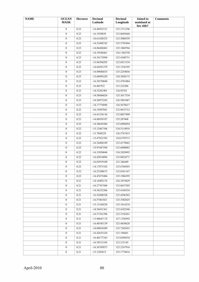
April-2010 80
NAME OCEAN MASK
Hectares Decimal Latitude
Decimal Longitude
Joined to mainland at
low tide?
Comments
0 0.23 -16.49452121 123.3712196
0 0.23 -16.1939839 123.8695668
0 0.23 -16.61420325 123.5080559
0 0.23 -14.52498742 125.5792494
0 0.23 -14.86468463 125.1860766
0 0.23 -14.19544461 126.1384758
0 0.23 -16.34175898 123.4100731
0 0.23 -15.96304295 123.6913154
0 0.23 -14.64591379 125.1536745
0 0.23 -14.89886835 125.2254036
0 0.23 -15.68995229 124.3858173
0 0.23 -16.29370048 123.4791084
0 0.23 -16.401932 123.222206
0 0.23 -14.52281901 124.92763
0 0.23 -14.58686024 125.3617334
0 0.23 -14.20472242 126.5841067
0 0.23 -14.17776896 126.5678617
0 0.22 -16.19207841 123.9633712
0 0.22 -16.41534136 123.0857499
0 0.22 -14.86959187 125.207408
0 0.22 -14.20645484 125.6096054
0 0.22 -15.12467106 124.5114918
0 0.22 -13.7849229 126.5767423
0 0.22 -15.47921592 124.6759715
0 0.22 -16.34484189 123.4179662
0 0.22 -15.97447594 123.6890882
0 0.22 -16.33950848 124.2028992
0 0.22 -16.42814096 123.0824571
0 0.22 -16.03919109 123.346449
0 0.22 -14.17873102 125.6768503
0 0.22 -16.53288673 123.0101167
0 0.22 -14.47675486 125.1986395
0 0.21 -14.16492176 126.1874429
0 0.21 -16.27767448 123.8657505
0 0.21 -14.56252206 125.4168524
0 0.21 -16.52688528 123.4296582
0 0.21 -16.57461021 123.3582025
0 0.21 -15.13160228 125.1814218
0 0.21 -14.56431361 125.4182546
0 0.21 -16.57341396 123.3156261
0 0.21 -13.90647174 127.1328592
0 0.21 -16.40345139 123.4830628
0 0.21 -14.09034289 125.7245653
0 0.21 -16.42653324 123.194681
0 0.21 -16.40177343 123.0598554
0 0.21 -16.39313105 123.315145
0 0.21 -16.36705073 123.2167916
0 0.21 -15.1203815 125.1774816

April-2010 81
NAME OCEAN MASK
Hectares Decimal Latitude
Decimal Longitude
Joined to mainland at
low tide?
Comments
0 0.21 -14.91903197 125.1402269
0 0.20 -16.39565851 124.2725429
0 0.20 -16.46133159 124.3927365
0 0.20 -16.14688221 123.5829709
0 0.20 -16.12969657 123.7898758
0 0.20 -16.3274456 123.8643288
0 0.20 -16.31303204 123.8654142
0 0.20 -16.33310586 123.5632543
0 0.20 -16.15796508 123.6214049
0 0.20 -14.16342901 126.2390935
0 0.20 -16.41847683 123.1963517
0 0.20 -16.22774517 123.4493173
0 0.20 -16.50001984 123.4012605
0 0.20 -16.04949128 123.4248758
0 0.20 -16.18826386 123.8188019
0 0.20 -16.23608633 123.4655905
0 0.20 -15.11799776 125.1702083
0 0.20 -14.20641318 126.5850547
1 0.19 -15.82030248 124.7567309
1 0.19 -14.63914285 125.448667
0 0.19 -16.16490749 123.6497705
0 0.19 -16.44912849 123.1319295
0 0.19 -16.73749004 123.6491093
0 0.19 -16.20502293 123.8759879
0 0.19 -16.50331899 123.413508
0 0.19 -14.41179162 125.2401524
0 0.19 -15.12120583 125.1974207
0 0.19 -16.16114284 124.0950757
0 0.19 -16.14325405 123.7493504
0 0.19 -16.24071786 123.4758205
0 0.19 -14.85861005 125.2363867
0 0.19 -14.48334499 127.8860523
0 0.19 -16.13151953 123.2938422
0 0.19 -14.91707386 125.1358116
0 0.19 -14.45566665 125.5105864
0 0.19 -16.19843813 123.8118135
0 0.19 -16.1184856 123.4489617
0 0.19 -14.05033952 126.3862163
0 0.19 -14.52560196 125.3319392
0 0.18 -16.38600262 123.1390216
0 0.18 -15.2245105 124.539656
0 0.18 -16.56721157 123.3492788
0 0.18 -14.94912518 125.1934294
0 0.18 -16.21770775 123.4377551
0 0.18 -16.1690775 123.8038309
0 0.18 -16.39579117 123.9691025
0 0.18 -16.05154119 123.4238153
0 0.18 -14.51145587 125.498197

April-2010 82
NAME OCEAN MASK
Hectares Decimal Latitude
Decimal Longitude
Joined to mainland at
low tide?
Comments
0 0.18 -16.09482027 124.0735889
0 0.18 -16.12425998 123.3805239
0 0.18 -14.16694168 126.2376675
0 0.18 -16.16366627 123.699213
1 0.18 -16.23244926 123.9269715
0 0.18 -14.98111187 125.2636618
0 0.18 -15.13700978 124.4946553
0 0.18 -16.13911297 123.4615692
0 0.18 -16.42026242 123.1663583
0 0.18 -16.12266966 123.3687879
0 0.18 -16.60335678 123.3858808
0 0.18 -16.29958649 123.4918488
0 0.18 -16.156584 123.6336061
0 0.17 -16.61585093 123.5336119
0 0.17 -14.84026479 125.1761993
0 0.17 -16.59866865 123.5358436
0 0.17 -14.49784559 125.4939693
0 0.17 -16.20749712 123.8407604
0 0.17 -16.5014432 123.4439536
0 0.17 -15.49248126 125.1305624
0 0.17 -15.2343539 124.9183905
0 0.17 -14.51063667 125.5282467
0 0.17 -16.12971797 123.4668294
0 0.17 -16.35320292 123.4019789
0 0.17 -14.51282854 125.9581797
0 0.16 -16.16775785 123.7039401
0 0.16 -16.18860795 123.4797429
0 0.16 -17.05085992 122.3280318
1 0.16 -16.4091692 123.9817454
0 0.16 -14.23672691 126.3007379
0 0.16 -16.28729354 123.4141839
0 0.16 -16.61263059 123.5393607
0 0.16 -16.46833165 123.4475042
0 0.16 -16.13612199 123.3000399
0 0.16 -16.19891032 123.8113916
0 0.16 -14.53285781 125.9371355
0 0.16 -16.13661537 123.7940861
0 0.16 -14.84187337 125.1693486
0 0.16 -16.14607307 123.3218982
1 0.16 -15.17388409 125.3334147
0 0.16 -16.07866106 123.580308
1 0.16 -16.38511025 124.1972549
0 0.16 -16.32715566 123.8637808
0 0.16 -14.47729834 125.2007878
0 0.16 -16.40348447 123.2106738
0 0.15 -16.53097353 123.0107232
0 0.15 -14.23346589 126.2991143
0 0.15 -16.22368729 123.8135597

April-2010 83
NAME OCEAN MASK
Hectares Decimal Latitude
Decimal Longitude
Joined to mainland at
low tide?
Comments
0 0.15 -16.30830535 124.3672791
0 0.15 -16.22914852 123.4552483
0 0.15 -16.15406114 123.4474265
0 0.15 -15.46407065 124.6542916
0 0.15 -16.35105499 123.4082798
0 0.15 -15.02842198 125.1561674
0 0.15 -16.48017749 123.0448916
0 0.15 -16.44830992 123.4025153
0 0.15 -16.06291775 123.5402192
0 0.15 -16.23318641 124.3769208
0 0.15 -16.49161598 123.6176188
0 0.15 -16.17649827 123.4194515
0 0.15 -14.71248647 128.2335391
0 0.15 -16.36480126 123.2109159
0 0.15 -16.35139979 123.6484083
0 0.15 -16.12993916 123.392277
1 0.15 -14.47519362 125.7593084
0 0.15 -16.37592099 123.3911905
0 0.15 -15.02058367 124.61735
0 0.14 -16.36692504 123.480519
0 0.14 -15.98573453 124.4758368
0 0.14 -16.35397823 123.5870744
0 0.14 -16.58977741 123.529059
0 0.14 -16.14647185 123.7985306
0 0.14 -14.83293824 125.180057
0 0.14 -16.44864181 123.1054146
0 0.14 -16.39693439 123.9700583
0 0.14 -14.52224755 124.9306216
0 0.14 -16.27413361 123.4475284
0 0.14 -16.51998214 123.0088875
0 0.14 -16.48101004 123.0475163
0 0.14 -15.52363971 123.1613267
1 0.14 -15.22122399 124.8680494
0 0.14 -16.61525142 123.040862
1 0.14 -16.25707806 123.746795
0 0.14 -16.23077133 124.378668
0 0.14 -14.86886187 125.2077264
0 0.14 -16.15470743 123.4617826
0 0.14 -16.1232855 123.3805549
0 0.14 -13.89056471 126.5907389
0 0.14 -16.36386022 123.4193506
0 0.13 -16.50217449 123.4177187
0 0.13 -16.39337515 124.2723206
0 0.13 -16.32999513 123.5592335
0 0.13 -16.27072536 123.8807475
0 0.13 -15.25378944 124.4122793
0 0.13 -13.89916981 126.3091089
1 0.13 -16.25740428 123.7487344

April-2010 84
NAME OCEAN MASK
Hectares Decimal Latitude
Decimal Longitude
Joined to mainland at
low tide?
Comments
0 0.13 -16.05654541 123.3443824
0 0.13 -16.1125187 123.6804745
0 0.13 -16.49314293 123.367397
0 0.13 -14.23379333 126.0854364
0 0.13 -16.26468718 124.1483063
0 0.13 -16.27072298 123.7646521
0 0.13 -14.47680303 125.1997194
0 0.13 -16.36904352 123.4844882
0 0.13 -14.83471184 125.1734469
0 0.13 -16.15520523 123.4623861
0 0.13 -14.86611246 125.2091426
1 0.13 -16.35264063 124.1871862
0 0.12 -14.15331752 126.2302406
0 0.12 -16.37801451 123.4088596
0 0.12 -14.75441575 125.1427307
0 0.12 -14.17703024 126.56771
0 0.12 -16.41917387 124.334445
0 0.12 -16.20920865 123.5425409
0 0.12 -16.13024457 123.2858659
0 0.12 -16.11140641 124.1000612
0 0.12 -16.16042837 123.3305065
0 0.12 -16.40438945 123.6366037
0 0.12 -16.45042868 123.3491151
0 0.12 -16.38628232 123.3063436
0 0.12 -16.31350266 123.3074109
0 0.12 -16.38428751 124.2602915
0 0.12 -16.4687268 123.4479389
0 0.12 -14.0643819 127.5119812
0 0.12 -16.34353818 123.4058272
0 0.12 -14.496308 125.3755381
0 0.12 -16.25371805 123.8414343
0 0.12 -16.44766233 123.1055139
0 0.12 -16.16559648 124.0678506
0 0.12 -15.11509829 125.1711179
1 0.11 -16.38491735 123.997011
0 0.11 -16.30721372 123.3187381
0 0.11 -16.13343498 123.3170682
0 0.11 -16.39001555 123.9512336
0 0.11 -16.24030058 123.5692641
0 0.11 -16.42049425 123.1029927
0 0.11 -14.14530733 126.2363089
0 0.11 -16.42138887 123.6023409
0 0.11 -16.15986207 123.3282081
0 0.11 -16.4503737 123.4021244
0 0.11 -16.13881579 123.794914
0 0.11 -16.5743365 123.3149884
0 0.11 -14.78110791 125.1852436
0 0.11 -16.39365637 123.0649272
April-2010 85
NAME OCEAN MASK
Hectares Decimal Latitude
Decimal Longitude
Joined to mainland at
low tide?
Comments
0 0.11 -16.22821685 124.1135628
0 0.11 -15.223187 124.7257054
0 0.11 -16.47541602 123.6068122
0 0.11 -16.45716674 123.3407789
0 0.11 -14.71216068 128.2320816
0 0.11 -14.53058323 125.4121172
0 0.11 -16.16034201 123.5336547
0 0.10 -16.55494044 123.3533433
1 0.10 -16.30049133 124.0019666
0 0.10 -14.4944345 125.9266573
0 0.10 -16.25138271 123.9732543
0 0.10 -13.88890842 126.6053011
0 0.10 -13.89452802 126.5988488
0 0.10 -15.51855424 123.1576591
0 0.10 -16.08193339 123.520746
0 0.10 -16.16571963 123.6987706
0 0.10 -16.19248622 123.4448234
0 0.10 -16.12221544 123.3670527
0 0.10 -16.19298915 123.5406331
0 0.10 -16.33921901 124.2013097
0 0.10 -16.49569957 123.3804251
0 0.10 -16.19202681 123.5393742
0 0.10 -16.49030406 123.5988909
0 0.09 -16.49120911 123.5995335
0 0.09 -14.49699261 125.4938084
0 0.09 -15.12026919 125.1722764
0 0.09 -16.3308161 123.5590529
0 0.09 -16.18977678 123.4799984
0 0.09 -14.53452169 125.9402069
0 0.09 -16.28102737 123.415325
0 0.09 -16.36053509 123.4168933
0 0.09 -16.13049109 123.46748
0 0.09 -16.20296132 123.8119703
0 0.09 -16.26420969 123.5765651
0 0.09 -15.35522621 124.3046146
0 0.09 -16.35820522 123.3897656
0 0.09 -14.84940564 125.1841041
0 0.09 -16.17987328 123.8118727
1 0.08 -16.638395 123.5399042
0 0.08 -16.60280127 123.3862684
0 0.08 -14.84870655 125.1853936
0 0.08 -14.82027197 125.1805514
0 0.08 -16.3072727 123.3180426
0 0.08 -16.49182576 123.5999787
0 0.08 -16.39411871 123.0644163
0 0.08 -14.52446359 125.1444629
0 0.08 -16.39602608 123.2108152
0 0.08 -16.45038126 123.0911139

April-2010 86
NAME OCEAN MASK
Hectares Decimal Latitude
Decimal Longitude
Joined to mainland at
low tide?
Comments
0 0.08 -16.35115789 123.9694114
0 0.08 -16.42123663 123.0795126
0 0.08 -16.19836647 123.527406
0 0.08 -16.20330522 123.8748958
0 0.08 -16.27519437 123.7825947
0 0.08 -16.393382 123.320202
0 0.08 -16.36667433 123.4311393
0 0.08 -14.53369016 125.9399943
0 0.08 -16.50296167 123.4158108
0 0.08 -16.40516522 123.2224855
0 0.08 -16.35227428 123.4060783
0 0.08 -16.45014572 123.0904578
0 0.08 -16.11590543 123.4469747
0 0.07 -16.12992216 123.466068
0 0.07 -16.50565787 123.4193007
0 0.07 -16.26646727 123.7781035
0 0.07 -16.24552882 123.5469619
0 0.07 -16.56639923 123.5731489
0 0.07 -16.44228988 123.0830933
0 0.07 -14.84160831 125.1751505
1 0.07 -16.1541094 123.6906054
0 0.07 -16.53211248 123.3521031
0 0.07 -16.20066804 123.8393035
0 0.07 -16.079122 123.5804447
0 0.07 -16.42742791 124.3577058
0 0.07 -16.21843584 123.4443394
0 0.07 -16.21435847 123.5661836
0 0.07 -14.50945464 125.5281279
0 0.07 -16.34352497 123.4063606
0 0.07 -16.21844354 123.4436304
0 0.07 -16.62815476 123.5297492
0 0.07 -16.34922027 123.4124834
0 0.07 -16.36486954 123.4512625
0 0.07 -16.08248202 123.4004686
0 0.07 -16.12996757 123.3941494
0 0.06 -16.4939195 123.5867418
1 0.06 -16.14505929 123.7190272
0 0.06 -14.75651632 125.1430785
0 0.06 -16.15517661 123.6652993
0 0.06 -16.37140706 123.4800476
0 0.06 -16.2048941 123.4672972
0 0.06 -16.20375695 123.8729622
0 0.06 -14.83908448 125.1726381
0 0.06 -16.24557297 123.5706272
0 0.06 -16.5936142 123.3717369
0 0.06 -16.60921661 123.4567878
0 0.06 -16.22958431 123.869836
0 0.06 -16.07827608 123.5801722

April-2010 87
NAME OCEAN MASK
Hectares Decimal Latitude
Decimal Longitude
Joined to mainland at
low tide?
Comments
0 0.06 -16.40796375 123.633381
1 0.06 -15.79523909 124.7771362
0 0.06 -14.91915925 125.1409499
0 0.06 -16.19425322 123.5591271
0 0.06 -16.44179127 123.1221471
0 0.06 -16.1694841 123.8044085
0 0.06 -15.04863592 125.3303787
0 0.06 -16.39890224 123.1356953
0 0.06 -16.07865921 123.4463071
0 0.06 -16.26766395 123.8783681
0 0.05 -16.13384735 123.3173554
0 0.05 -16.13417691 123.7063925
0 0.05 -14.91623802 125.1350261
0 0.05 -16.49143964 123.606423
0 0.05 -16.30932155 123.2710027
0 0.05 -16.27375609 123.5639715
0 0.05 -16.38332973 123.1393225
0 0.05 -16.19012026 123.5319847
0 0.05 -14.71150654 128.2321524
0 0.05 -16.59411459 123.3724272
0 0.05 -16.44141767 123.082207
0 0.05 -14.92402008 125.1462767
0 0.05 -16.16409164 123.3542456
0 0.05 -16.2054889 123.4690203
0 0.05 -16.27023736 123.8794812
0 0.05 -16.60932445 123.4559999
0 0.05 -16.45101036 123.1326115
0 0.05 -16.19818778 123.5267729
0 0.05 -16.241495 124.0042037
1 0.05 -16.28690039 123.9934735
0 0.05 -16.36479815 123.4361642
0 0.05 -14.45547428 125.5456214
0 0.05 -16.497266 123.577166
0 0.05 -13.9422017 126.7135475
0 0.04 -14.8388704 125.1729379
0 0.04 -16.36761374 123.6007213
0 0.04 -16.04870845 123.5608753
0 0.04 -16.20360154 123.5416434
0 0.04 -16.28436941 123.7813589
0 0.04 -16.18298014 123.5902241
0 0.04 -16.30721627 123.8494055
0 0.04 -16.15405965 123.7248412
1 0.04 -16.22521611 123.5746299
0 0.04 -16.15407986 123.7132306
0 0.04 -16.42645703 123.0889145
0 0.04 -16.4505711 123.0884225
0 0.04 -16.59153248 123.3688794
0 0.04 -16.15446386 123.7247328
April-2010 88
NAME OCEAN MASK
Hectares Decimal Latitude
Decimal Longitude
Joined to mainland at
low tide?
Comments
0 0.04 -16.39833141 123.6249189
0 0.04 -16.14363651 123.7970907
0 0.04 -16.40604691 123.4668551
0 0.04 -16.30506925 123.3151562
0 0.04 -14.92003715 125.1434041
0 0.04 -16.55079131 123.3489407
0 0.04 -14.91891758 125.1380919
0 0.04 -16.34521015 123.4177248
0 0.04 -14.70927156 124.972098
0 0.04 -16.41997076 123.1023184
0 0.03 -16.45043545 123.0898899
0 0.03 -16.22082015 123.4413727
0 0.03 -16.17927756 123.5933545
0 0.03 -14.83954368 125.1729582
0 0.03 -16.34465457 123.4184961
0 0.03 -16.40266458 123.4803484
0 0.03 -16.20514448 123.4682177
0 0.03 -16.44177644 123.0821359
0 0.03 -16.45047437 123.0871985
0 0.03 -16.27542625 123.8104835
0 0.03 -14.91806339 125.1545505
1 0.03 -16.1447725 123.7185768
0 0.03 -16.59859508 123.5143523
0 0.03 -16.1380053 123.7945056
0 0.03 -16.38990383 123.166159
0 0.03 -16.1686765 123.4109042
0 0.03 -16.17781168 123.8844738
0 0.03 -16.42609739 123.0893207
0 0.03 -16.24121718 124.0042848
0 0.02 -14.91770368 125.1541746
0 0.02 -16.18772501 123.8181496
0 0.02 -14.92197882 125.1239768
1 0.02 -16.17642625 123.7406096
0 0.02 -16.59131857 123.3710872
0 0.02 -14.91711201 125.1381739
0 0.02 -13.9425592 126.7131489
0 0.02 -16.37477473 123.4836829
0 0.02 -16.21837547 123.4440029
0 0.02 -16.44540783 123.0865933
0 0.02 -16.14569495 123.7978252
0 0.02 -16.58188759 123.3605815
0 0.02 -16.38883123 123.1668738
0 0.02 -16.54080667 123.3591133
0 0.01 -16.47637369 123.6088325
0 0.01 -16.15352807 123.724196
0 0.01 -16.42725964 123.0888345
0 0.01 -16.21892 123.5480647
0 0.01 -16.18643028 123.8116036

April-2010 89
APPENDIX 2. Methods used in developing a list of Kimberley islands Tom Hughson and Andrew Burbidge The north Kimberley coast has extreme tides, with more than an 11 metre range in places, and is heavily incised with many embayments, mangrove forests, narrow valleys and tidal rivers. Developing a list of Kimberley islands was not straightforward as some of the many features that show up on maps and digital coastal/island boundaries are close to the coast and may appear to be joined to it by mangroves or tidal flats. Available topographic and digitised maps are often unclear about what ‘an island’ is and what intertidal areas are. A set of rules was therefore developed to guide decisions about what features were included or excluded from the list. The basis for developing the rules was to identify islands as places where most terrestrial organisms would not be able to move between the island and the adjacent mainland, i.e., where there would be no or very limited gene flow. Where doubt existed about whether a feature was an island the following rules were observed.
1. Above high water mark land masses separated from the mainland by mangrove-lined channels which fill at high tide but are dry at low tide were considered islands, but noted in the database as being joined to the mainland at low tide.
2. Above high water mark land masses joined to the mainland by supra-tidal flats (or supra-littoral zone, ie, not normally submerged by ocean water, but sea water penetrates during extreme spring tides or storm surges) were not considered islands. Such areas include low-lying areas surrounded by mangroves that remain dry most of the time, even if lightly vegetated by salt-tolerant plants.
3. Mangrove patches surrounded by ocean but with no land above high water mark were not considered to be islands.
Datasets used for the geographic analysis The principal data layer which was used to derive the estimates of island size, location and number was the layer titled ‘Polygonised Coast of Western Australia’. Its description provided in the metadata statement is:
This dataset consists of polygons delineating the coastline of Western Australia and includes the mainland, islands, intertidal and subtidal waters out to the limit of Coastal Waters of the state. Polygons were derived from the best available High Water (HWM), Low Water (LWM) and Mean High Water Mark (MHWM) linework from the WA Department of Land Information (DLI) as at August 2006, unioned with the latest Australian Maritime Boundaries (AMB) WA Coastal Waters extent. Polygons are attributed as Mainland (landward of the mainland HWM), Island (landward of island HWMs), Intertidal (between HWM and LWM) or Subtidal (seaward of the LWM, out to the limit of Coastal Waters of the state). (The Department of Environment and Conservation (DEC) is listed as the custodian of its own corporate dataset)
A subset of the above dataset was extracted which included only the polygons described as ‘Islands’. Part of the verification process involved closely analysing the polygons which were potentially connected to the mainland by tidal flats and/or mangroves. Near-shore islands were selected from the islands sub-set for analysis using another layer in the DEC corporate dataset which is titled ‘ocean-mask’. This layer is highly stylised and is probably more often used for map production than analysis, however the general extent of the layer was broadly suitable for this task.
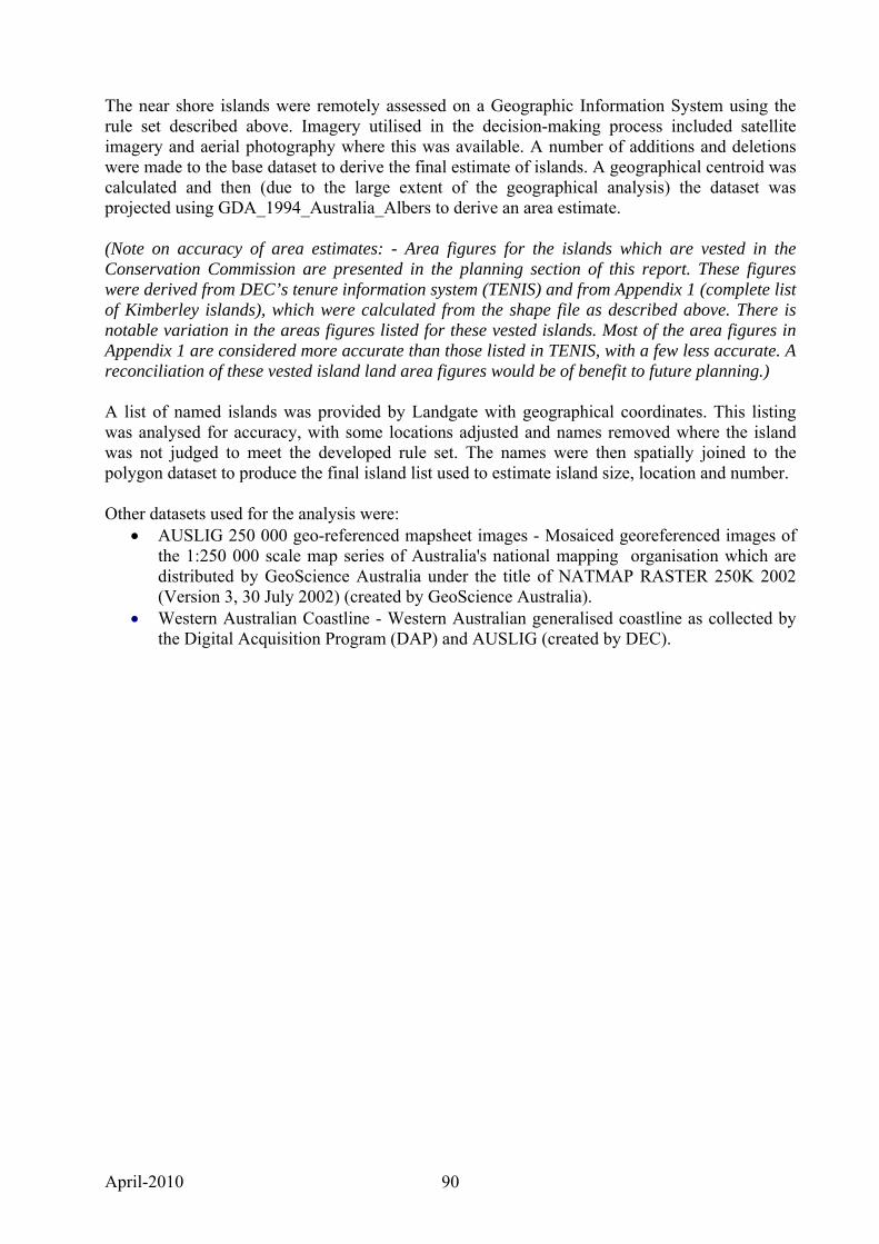
April-2010 90
The near shore islands were remotely assessed on a Geographic Information System using the rule set described above. Imagery utilised in the decision-making process included satellite imagery and aerial photography where this was available. A number of additions and deletions were made to the base dataset to derive the final estimate of islands. A geographical centroid was calculated and then (due to the large extent of the geographical analysis) the dataset was projected using GDA_1994_Australia_Albers to derive an area estimate. (Note on accuracy of area estimates: - Area figures for the islands which are vested in the Conservation Commission are presented in the planning section of this report. These figures were derived from DEC’s tenure information system (TENIS) and from Appendix 1 (complete list of Kimberley islands), which were calculated from the shape file as described above. There is notable variation in the areas figures listed for these vested islands. Most of the area figures in Appendix 1 are considered more accurate than those listed in TENIS, with a few less accurate. A reconciliation of these vested island land area figures would be of benefit to future planning.) A list of named islands was provided by Landgate with geographical coordinates. This listing was analysed for accuracy, with some locations adjusted and names removed where the island was not judged to meet the developed rule set. The names were then spatially joined to the polygon dataset to produce the final island list used to estimate island size, location and number. Other datasets used for the analysis were:
• AUSLIG 250 000 geo-referenced mapsheet images - Mosaiced georeferenced images of the 1:250 000 scale map series of Australia's national mapping organisation which are distributed by GeoScience Australia under the title of NATMAP RASTER 250K 2002 (Version 3, 30 July 2002) (created by GeoScience Australia).
• Western Australian Coastline - Western Australian generalised coastline as collected by the Digital Acquisition Program (DAP) and AUSLIG (created by DEC).
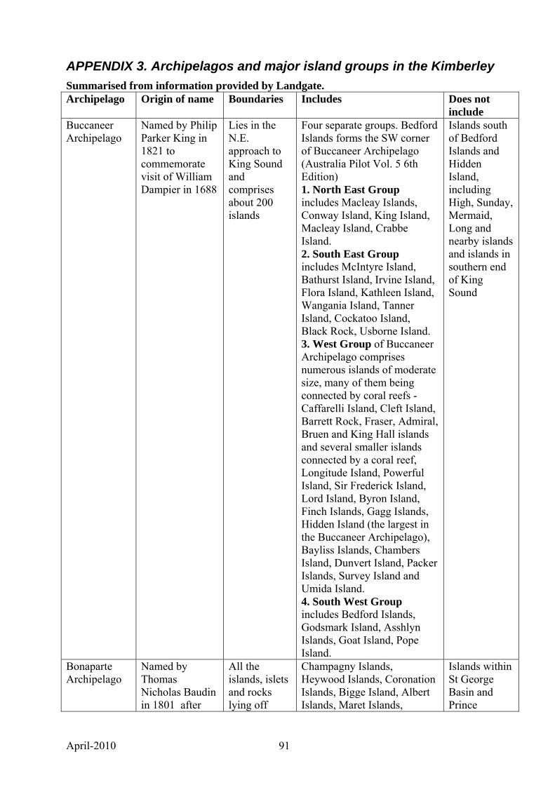
April-2010 91
APPENDIX 3. Archipelagos and major island groups in the Kimberley Summarised from information provided by Landgate. Archipelago Origin of name Boundaries Includes Does not
include Buccaneer Archipelago
Named by Philip Parker King in 1821 to commemorate visit of William Dampier in 1688
Lies in the N.E. approach to King Sound and comprises about 200 islands
Four separate groups. Bedford Islands forms the SW corner of Buccaneer Archipelago (Australia Pilot Vol. 5 6th Edition) 1. North East Group includes Macleay Islands, Conway Island, King Island, Macleay Island, Crabbe Island. 2. South East Group includes McIntyre Island, Bathurst Island, Irvine Island, Flora Island, Kathleen Island, Wangania Island, Tanner Island, Cockatoo Island, Black Rock, Usborne Island. 3. West Group of Buccaneer Archipelago comprises numerous islands of moderate size, many of them being connected by coral reefs - Caffarelli Island, Cleft Island, Barrett Rock, Fraser, Admiral, Bruen and King Hall islands and several smaller islands connected by a coral reef, Longitude Island, Powerful Island, Sir Frederick Island, Lord Island, Byron Island, Finch Islands, Gagg Islands, Hidden Island (the largest in the Buccaneer Archipelago), Bayliss Islands, Chambers Island, Dunvert Island, Packer Islands, Survey Island and Umida Island. 4. South West Group includes Bedford Islands, Godsmark Island, Asshlyn Islands, Goat Island, Pope Island.
Islands south of Bedford Islands and Hidden Island, including High, Sunday, Mermaid, Long and nearby islands and islands in southern end of King Sound
Bonaparte Archipelago
Named by Thomas Nicholas Baudin in 1801 after
All the islands, islets and rocks lying off
Champagny Islands, Heywood Islands, Coronation Islands, Bigge Island, Albert Islands, Maret Islands,
Islands within St George Basin and Prince
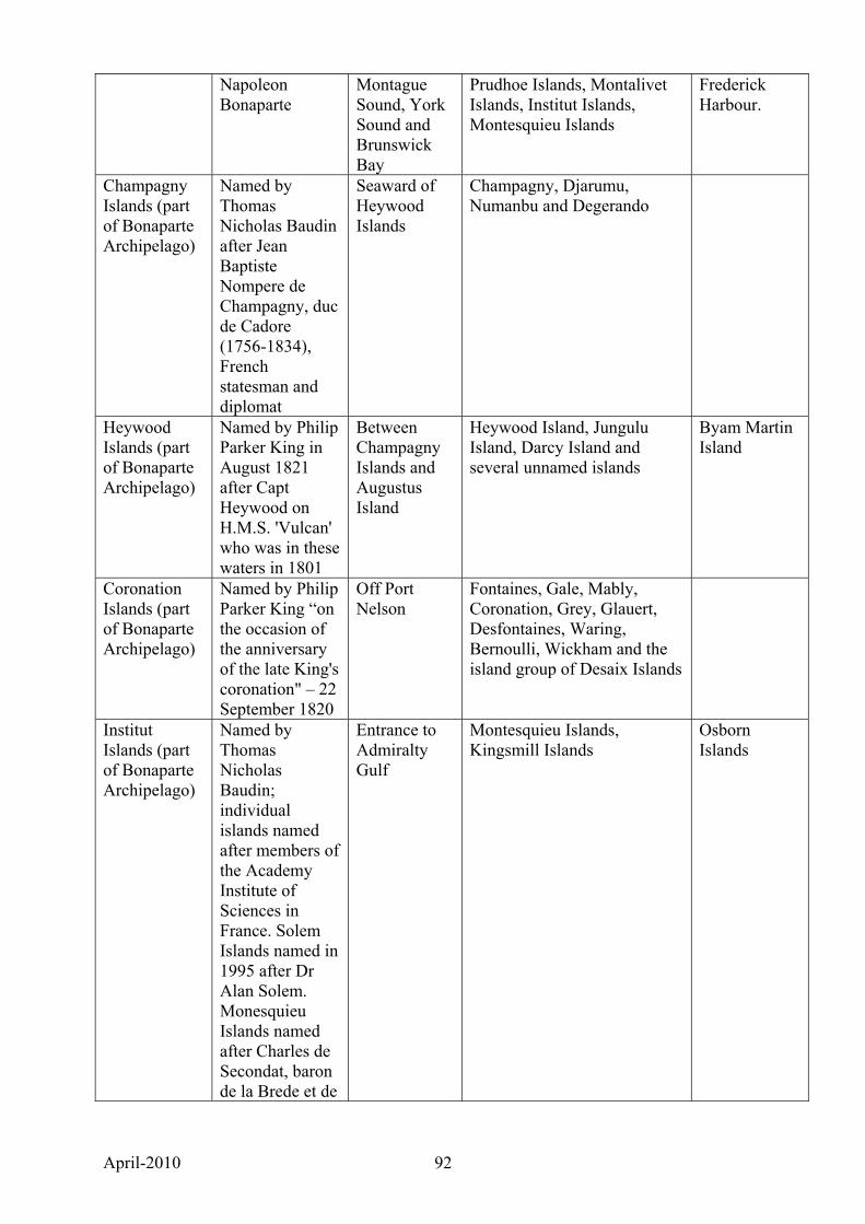
April-2010 92
Napoleon Bonaparte
Montague Sound, York Sound and Brunswick Bay
Prudhoe Islands, Montalivet Islands, Institut Islands, Montesquieu Islands
Frederick Harbour.
Champagny Islands (part of Bonaparte Archipelago)
Named by Thomas Nicholas Baudin after Jean Baptiste Nompere de Champagny, duc de Cadore (1756-1834), French statesman and diplomat
Seaward of Heywood Islands
Champagny, Djarumu, Numanbu and Degerando
Heywood Islands (part of Bonaparte Archipelago)
Named by Philip Parker King in August 1821 after Capt Heywood on H.M.S. 'Vulcan' who was in these waters in 1801
Between Champagny Islands and Augustus Island
Heywood Island, Jungulu Island, Darcy Island and several unnamed islands
Byam Martin Island
Coronation Islands (part of Bonaparte Archipelago)
Named by Philip Parker King “on the occasion of the anniversary of the late King's coronation" – 22 September 1820
Off Port Nelson
Fontaines, Gale, Mably, Coronation, Grey, Glauert, Desfontaines, Waring, Bernoulli, Wickham and the island group of Desaix Islands
Institut Islands (part of Bonaparte Archipelago)
Named by Thomas Nicholas Baudin; individual islands named after members of the Academy Institute of Sciences in France. Solem Islands named in 1995 after Dr Alan Solem. Monesquieu Islands named after Charles de Secondat, baron de la Brede et de
Entrance to Admiralty Gulf
Montesquieu Islands, Kingsmill Islands
Osborn Islands

April-2010 93
Montesquieu (1689-1755), magistrate, man of letters, philosopher and a former Member of the French Academy of Sciences.
Osborn Islands
Named by Philip Parker King in 1819 after Sir John Osborn, one of the Lords of the Admiralty. (Aboriginal name: Pelaga)
Western side of Admiralty Gulf
Borda Island, Carlia Island, Middle Osborn Island, South West Osborn Island, Kidney Island, Centre Rock, West Rock and North Rock
Eclipse Islands
Named by Philip Parker King after an eclipse that took place on 2 October 1819 (Aboriginal name: Nganguru)
Entrance to Vansittart Bay
Sir Graham Moore Islands
Named by Philip Parker King in 1819 after Sir Graham Moore, then holding a seat on the English Admiralty Board
Entrance to Napier Broome Bay
Sir Graham Moore Island, Scorpion Island
Governor Islands
April-2010 94
APPENDIX 4. Kimberley islands annotated bibliography and notes on unpublished data 1. Kimberley islands published papers and reports Burbidge, A.A. and McKenzie, N.L. (eds) (1978). The islands of the north-west Kimberley,
Western Australia. Wildlife Research Bulletin Western Australia No. 7. Department of Fisheries and Wildlife, Perth.
Data on vascular flora and vertebrate fauna of islands visited in 1971, 1972 and 1973 by
Department of Fisheries and Wildlife expeditions accompanied by staff from the WA Museum and WA Herbarium. Islands visited (with varying amounts of data) were: Adele, Augustus, Bat, Bigge, Boongaree, Borda, Browse, Byam Martin, Carlia, Champagny, Commerson, Coronation, East Montalivet, Fenelon, Heywood, Jungulu (as Darcy), Katers, Kingfisher, Louis, Low Rocks, Melomys, Middle Osborn, North Eclipse, Saint Andrew, Sir Graham Moore, South Maret, South West Osborn, Uwins and Wollaston.
Burbidge, A.A. and Morris, K.D. (2002). Introduced mammal eradications for nature
conservation on Western Australian islands: a review. In: Veitch, C. R.; Clout, M. N. (eds) Turning the tide: the eradication of invasive species. Auckland, IUCN SSC Invasive Species Specialist Group, pp. 64-70.
Summarises feral animal eradications on Western Australian islands, including the Lacepede
Islands. Burbidge, A.A., Fuller, P.J., Lane J.A.K. and Moore, S.A. (1978). Counts of nesting boobies
and Lesser Frigate-birds in Western Australia. Emu 87, 128-9.
Includes data on brown boobies and lesser frigatebirds on Adele Island and Lacepede Islands.
CALM (1998). Marine turtle recovery plan for Western Australia. Draft. Department of
Conservation and Land Management, Perth. States that the following Kimberley islands have important rookeries:
Green Turtle: Lacepede Islands, Sandy Island (Scott Reef), Browse Island, Cassini Island. Flatback Turtle: Helpman Island, Troughton Island.
Coate, K. (1997). Adele Island, Western Australia. Seabird Island Series No. 236. Corella 21(3):
124-128. Detailed information on seabirds of Adele Island. Coate, K. (2004). Booby Island (formerly White Island), Kimberley Region, Western Australia.
Corella 28(4): 110-111. Seabird Island Series No. 248. Detailed information on seabirds of Booby Island Coate, K. (2006). Rose-crowned Fruit-dove on Maret Island - a new location and food source.
Western Australian Naturalist 25, 191.
April-2010 95
Information on birds of the Maret Islands. Coate, K. (2008). Birds of Naturalists Island, Kimberley, Western Australia. Western Australian
Naturalist 26, 73-84. Comprehensive summary of the birds of Naturalists Island. Coate, K. (2008). Pied Imperial Pigeon and Red-tailed Black Cockatoo commuting to the
Coronation Islands, Kimberley, Western Australia. Western Australian Naturalist 26, 216-217.
Information on birds of the Coronation Islands. Coate, K. (2005). Kimberley bird sightings from 1962. Unpublished. Author, Perth. Comprehensive information on the birds of many Kimberley islands. Summarised in
Appendix 5. Coate, K. (2009). Kimberley bird sightings from 2005. Unpublished. Author, Perth. Comprehensive information on the birds of many Kimberley islands. Summarised in
Appendix 5. Coate, K., Done, C. and Willing, T. (2004). Sterna Island, Kimberley Region, Western Australia.
Seabird Island Series No. 249. Corella 28(4): 112-114.
Summarises information on seabirds of Sterna Island. Coate, K.H., Smith, L.A. and Fontanini, L. (1994). The birds of Adele Island, Western Australia,
including notes on recently established breeding colonies of Red-footed Boobies (Sula sula) and Great Frigate Birds (Fregata minor). Western Australian Naturalist 19: 285-291.
Summarises information on the seabirds of Adele Island.
Cornell, C. (Translator) (1974). The Journal of Post captain Nicholas Baudin. Libraries Board of
South Australia, Adelaide. Narrative of the Baudin expedition, which traversed the Kimberley coast in July and August
1801. Crawford, I.M. (1968). The Art of the Wandjina. Aboriginal Cave Paintings in Kimberley,
Western Australia. Oxford University Press, Melbourne. Documents Wandjina and Gwion Gwion Aboriginal art and culture of the Kimberley,
including Bigge Island and some other islands. A few natural history collections made during expeditions are lodged in the WA Museum.
Environmental Protection Authority (1990). Application for a special lease on Cassini Island:
BHP Petroleum Pty Ltd: Report and recommendations of the Environmental protection Authority. Bulletin 474. EPA, Perth.
April-2010 96
Includes limited biodiversity data for Cassini Island. BHPP sought a special lease to build and operate an airstrip on the island. EPA concluded that the proposal was environmentally unacceptable. Notes that CALM had applied for the island to be reserved for nature conservation and that the island has a turtle rookery.
Hassell, C. (1999). Bird counts on the Lacepedes 09/10/1999. Report to CALM. Reports counts of seabirds made on a visit to the Lacepede Islands in October 1999. Hassell, C. (2003). A bird survey with the Australian Quarantine Inspection Service of some
Kimberley islands and Ashmore Reef. 22nd to 26th february 2003. Unpublished Report to AQIS.
Reports observations of birds on Adele Island, East, West and Middle Islands (Ashmore
Reef), one of the Albert Islands and Cassini Island. Hassell, C. and Boyle, A. (2002). Breeding roseate terns in the Kimberley. Western Australian
Bird Notes No 101, pp 12-13. Reports large breeding colonies of roseate terns on Twin Islands, north of King Sound. Hassell, C. and Sparrow, J. (1998). Trip Report – Lacepede Islands. Report to CALM. Reports observations by 15 people made on a trip to the Lacepede islands in October, 1998.
Detailed bird counts made on 1 September and 14 October provided separately. Hassell, C. (1999). Bird counts on the Lacepedes 09/10/1999. Report to CALM. Reports bird counts on the Lacepede islands made by Broome Bird Observatory staff and
volunteers and a CALM officer on West and Middle Islands. Hill, G.F. (1911). Field notes on birds of the Kimberley, North West Australia. Emu 10, 258-90. Notes are about birds of Napier Broome Bay and the Drysdale River near the old Pago
Mission. However, Hill made ‘several brief visits to islands and many points of the mainland between that bay (Napier Broome Bay) and Gibson Point (Parry Harbour) and on my return by lugger to Derby in July further opportunities were afforded for seeing much of the coast and adjacent islands of the Kimberley’ (p. 259). Only islands mentioned by name are Hecla and Augustus.
How, R., Schmitt, L., Teale, R. and Cowan, M. (2006). Appraising vertebrate diversity of
Bonaparte Islands, Kimberley, Western Australia. Western Australian Naturalist 25, 92-110.
Documents biological collections and observations made on 35 islands in 2002 – 2005.Islands examined were: Berthier, Bigge, Bonaparte, Boongaree, Buffon, Capstan, Carlia, Cassini, Colbert, Corneille, Coronation, Descartes, Don, Fenelon, Glauert, Grey, Hedley, Keraudren, Kidney, Lafontaine, Low Rocks, Maret (as Maret North), South Maret, McCullouch, East Montalivet, West Montalivet, Middle Osborn, South West Osborn, Parry, Purrungku (East), Steep Head, unnamed (14º36’S, 125º14’E), Walker, Whitley and Woodward.
April-2010 97
Keighery, G.K., Gibson, N. and Kenneally, K.F. (1995). Biological inventory of Koolan Island, Westen Australia. 1. Flora and vegetation. Records of the Western Australian Museum 17, 237-248.
Detailed information on the flora and vegetation of Koolan Island, Buccaneer Archipelago. Kenneally, K., Edinger, D. and Coate, K. (1996). Buccaneer Archipelago 1996. Landscope
Expedition Report No. 15. Department of Conservation and Land Management, Bentley, and UWA Extension, Nedlands.
Narrative and data including visits to Lacepede Islands, Koolan Island, Cockatoo Island and
Mulgudna Island. Kimberley Land Council and Dept of Aboriginal Affairs. (2006). Solwoda Kantri. Final report to
the Rangelands NRM Coordinating Group on the 'Saltwater Country Coastal Project, Northwest Kimberley', November 2004 - June 2006.
Documents indigenous values and assets of marine and coastal environments of the north
Kimberley. Proposes management frameworks and policy directions. King, P.P. (1827). Narrative of a survey of the intertropical and western coasts of Australia
performed between the years of 1818 and 1822. John Murray, London. Narrative of hydrographical survey of Kimberley coast and islands. Includes natural history
observations. Maryan, B. and Robinson, D. (1997). An insular population of Lerista griffini and and comments
on the identity of Lerista praefrontalis (lacertilia: Scincidae). Western Australian Naturalist 21.
Reports a visit to King Hall Island to search for Lerista praefrontalis and suggests that it is
an aberrant L. griffini. McKenzie, N.L., Fontanin, L., Lindus, N.V. and Williams, N.R. (1995). Biological inventory of
Koolan Island, Westen Australia. 2. Zoological notes. Records of the Western Australian Museum 17, 249-266.
Detailed information on the fauna of Koolan Island, Buccaneer Archipelago. McKenzie, N.L., Johnston, R.B. and Kendrick, P.G. (Eds) (1991). Kimberley Rainforests of
Australia. Surrey Beatty and Sons, Chipping Norton, New South Wales. Detailed information on rainforest patches in the Kimberley, including those on Augustus,
Bigge, Boongaree, Glauert, Middle Osborn, Saint Andrew and South West Osborn Islands. Morgan, G.J. (Ed.) (1992). Survey of the Kimberley islands and reefs, Western Australia.
Western Australian Museum, Perth. Report on biological surveys of Kimberley islands in August 1991. Collections were made
mainly of marine animals and plants, but includes some data on terrestrial molluscs and freshwater fishes and molluscs. Includes data from an unnamed island south of Fenelon Island at 14º09’S, 125º39’E and West Montalivet Island.
April-2010 98
Serventy, D.L. (1952). Birds of islands of the Sahul Shelf. Emu 52, 33-59. Includes data on birds of Scott Reef, Seringapatam Reef, Sandy Island (Long Reef), Stewart
Islands, Jones Island, Lesueur Island, Low Rocks, Browse Island, Booby Island (as White Island), Adele Island and the Lacepede Islands.
Söderberg, R. (1918). Results off Dr E. Mjöberg’s Swedish Scientific Expeditions to Australia
1910-1913. Kungl. Sv. Vet. Akademiens Handlingar 52 No. 17, 1-116.
Includes observations of birds on Sunday Island. Start, A.N., Burbidge, A.A., McKenzie, N.L. and Palmer, C. (2007). The status of mammals in
the north Kimberley, Western Australia. Australian Mammalogy 29, 1-16. A re-appraisal of the status of terrestrial mammals at sites visited in the 1970s. Includes data
on Bigge, Boongaree, Uwins and Augustus Islands. Stokes, J.L. 1846. Discoveries in Australia, etc. 2 Vols. T & W Boone, London. Includes narrative of a hydrographical survey of Kimberley coast in 1838. Warham, J. (1957). Cockatoo Island birds. Emu 57, 225-231. Includes an annotated list of birds observed on Cockatoo Island in July and August 1956.
Makes comparisons with birds of Sunday Island. Mentions that a ‘rabbit rat (Mesembriomys)’ lived on the island. Only Kimberley rock-rats have been collected there.
Wells, F.E. (1989). Survey of the invertebrate fauna of the Kimberley islands, Western Australia.
A report to the National Geographic Society. Western Australian Museum, Perth. Includes a preliminary report by Alan Solem (Field Museum of Natural History, Chicago) on
land snails collected by Vince Kessner and A.F. Longbottom at 101 stations on 82 islands. Many marine collections made also. Appendix A lists collecting stations for land mollusca, including many unnamed islands, some of which have since been named.
2. Unpublished data Biological collections. The collections of the Western Australian Museum and Western
Australian herbarium have specimens collected on Kimberley islands. Buccaneer Archipelago expedition 1982. Department of Fisheries and Wildlife research
scientists and other staff conducted a biological survey of islands in the Buccaneer Archipelago and adjacent islands in King Sound in 1982. Botanical collections were lodged in the WA Herbarium and zoological collections were lodged in the WA Museum. Islands examined were: Bathurst, Caffarelli, Conilurus, East Sunday, Gibbings, Hidden, Irvine, King Hall, Long, Lachlan, Macleay, Sir Frederick and Sunday.
Bamford Consulting for Inpex. Bamford Consulting conducted biological surveys of Maret
and South Maret Islands, which at the time were the proposed site of a liquefied natural gas plant. For comparison the nearby Berthier, East and West Montalivet, Walker and the largest of the Albert Islands were also surveyed, and a brief visit was made to Bigge Island. Lists of
April-2010 99
specimens collected were sent to DEC as a requirement of the company’s scientific licence return. Full survey data are not currently available.
Kimberley islands Biological Survey. DEC scientists together with scientists from the WA
Museum, are carrying out detailed biological surveys of 22 of the largest islands off the Kimberley. Field work commenced in the 2007 dry season and is programmed to finish in the 2009-10 wet season. Surveys are site-based and include mammals, birds (opportunistic data only), reptiles, frogs, terrestrial and aquatic molluscs and vascular plants. Islands surveyed are: Adolphus, Augustus, Bigge, Boongaree, Byam Martin, Coronation, Jungulu, Hidden, Katers, Kingfisher, Lachlan, Long, Middle Osborn, unnamed (16.2488ºS, 123.8208ºS, NW of Molema), Sir Graham Moore, St Andrew, Storr, Sunday, Uwins, unnamed (15.9367ºS, 124.4590ºE) and Wulalam. The results of the survey will be published.
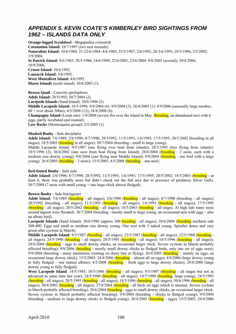
April-2010 100
APPENDIX 5. KEVIN COATE’S KIMBERLEY BIRD SIGHTINGS FROM 1962 – ISLANDS DATA ONLY Orange-legged Scrubfowl - Megapodius reinwardt Coronation Island: 18/7/1997 (two nest mounds). Naturalists Island: 10/6/1984. 21-22/6/1984; 4/6/1985; 25/5/1987; 2/6/1992; 28-3/6/1993; 29/5/1996; 5/5/2002; 3/9/2004. St Patrick Island: 8/6/1985; 28/5/1986; 14/6/1989; 22/6/2003; 23/6/2004. 8/8/2005 (several); 29/4/2006; 10/9/2006. Crosse Island: 10/6/1992. Lamarck Island: 3/6/1992. West Montalivet Island: 4/6/1992. Maret Islands (north island): 10/8/2005 (1). Brown Quail - Coturnix ypsilophora Adele Island: 28/51992; 30/7/2004 (2). Lacepede Islands (Sand Island): 30/6/1996 (2). Middle Lacepede Island: 18/5/1996; 9/8/2004 (6): 9/9/2004 (3). 26/4/2005 (1); 4/9/2006 (unusually large number, 60 + over about 300m); 4/5/2008 (12); 28/8/2008 (8). Champagny Island (Loran site): 1/9/2008 (severe fire over the island in May. Breeding, an abandoned nest with 6 eggs, partly incubated and roasted). Low Rocks (Montesquieu group): 2/5/2005 (1). Masked Booby - Sula dactylatra Adele Island: 7/6/1989; 2/6/1990; 8/7/1990; 28/51992; 11/5/1993; 1/6/1993; 17/5/1995; 20/5/2002 (breeding in all stages); 18/5/2003 (breeding in all stages); 30/7/2004 (breeding - small to large young). Middle Lacepede Island: 9/5/1987 (one flying over boat from islands); 28/5/1995 (two flying from islands); 18/5/1996 (2); 30/4/2002 (one seen from boat flying from Island); 28/6/2004 (breeding - 2 nests, each with a medium size downy young); 9/8/2004 (one flying near Middle Island); 9/9/2004 (breeding - one bird with a large young). 26/4/2005 (breeding – 3 nests); 15/5/2005; 4/5/2008 (breeding – one nest). Red-footed Booby - Sula sula Adele Island: 2/6/1990; 8/7/1990; 28/51992; 11/5/1993; 1/6/1993; 17/5/1995; 20/5/2002; 18/5/2003 (breeding - at least 6, there was probably more but didn’t check out the full area due to presence of predatory Silver Gull); 30/7/2004 (7 nests with small young + one large chick almost fledged). Brown Booby - Sula leucogaster Adele Island: 7/6/1989 (breeding - all stages); 2/6/1990 (breeding - all stages); 8/7/1990 (breeding - all stages); 28/51992 (breeding - all stages); 11/5/1993 (breeding - all stages); 1/6/1993 (breeding - all stages); 17/5/1995 (breeding - all stages); 20/5/2002 (breeding - all stages); 18/5/2003 (breeding - all stages. At high tide many nests around lagoon were flooded). 30/7/2004 (breeding - mostly small to large young, an occasional nest with eggs – also an albino bird). Lacepede Islands (Sand Island): 30/6/1996 (approx 300 breeding - all stages); 28/6/2004 (breeding northern side 300-400. Eggs and small to medium size downy young. One nest with 3 naked young. Spinifex dense and very green after cyclone in March). Middle Lacepede Island: 9/5/1987 (breeding - all stages); 23/5/1987 (breeding - all stages); 12/5/1988 (breeding - all stages); 24/5/1990 (breeding - all stages). 28/5/1995 (breeding - all stages); 18/5/1996 (breeding - all stages); 28/6/2004 (breeding - eggs to small downy chicks, an occasional larger chick. Severe cyclone in March probably affected breeding); 9/8/2004 (breeding - mostly small downy chicks to fledged birds, only one set of eggs seen); 9/9/2004 (breeding - many immatures roosting on shore line or flying). 26/4/2005 (breeding – mainly on eggs, an occasional large downy chick); 15/5/2005; 24/4/2006 (breeding – almost all on eggs); 4/9/2006 (large downy young to fully fledged – one mature albino); 4/5/2008 (breeding – fresh eggs to large downy chicks); 28/8/2008 (large downy young to fully fledged). West Lacepede Island: 14/5/1985; 10/5/1986 (breeding - all stages); 9/5/1987 (breeding - all stages but not as advanced as same time last year); 24/5/1990 (breeding - all stages); 19/7/1990 (breeding. large young); 24/5/1993 (breeding - all stages); 28/5/1995 (breeding - all stages); 18/5/1996 (breeding - all stages); 30/6/1996 (breeding - all stages); 30/4/2002 (breeding - all stages); 27/4/2004 (breeding - all birds on eggs which is unusual. Severe cyclone in March probably affected breeding); 28/6/2004 (breeding - eggs to small downy chicks, an occasional larger chick. Severe cyclone in March probably affected breeding); 9/8/2004 (breeding - chicks to fledged young); 9/9/2004 (breeding - medium to large downy chicks to fledged young). 26/4/2005 (breeding - eggs); 15/5/2005; 24/4/2006
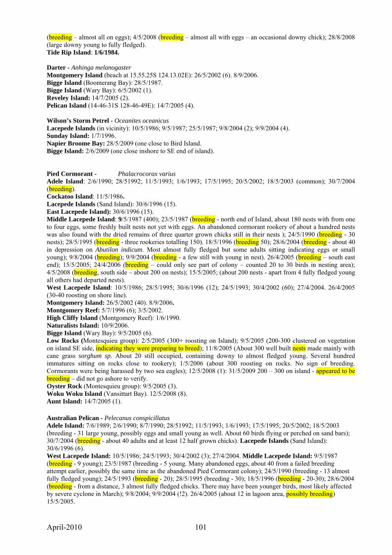
April-2010 101
(breeding – almost all on eggs); 4/5/2008 (breeding – almost all with eggs – an occasional downy chick); 28/8/2008 (large downy young to fully fledged). Tide Rip Island: 1/6/1984. Darter - Anhinga melanogaster Montgomery Island (beach at 15.55.25S 124.13.02E): 26/5/2002 (6). 8/9/2006. Bigge Island (Boomerang Bay): 28/5/1987. Bigge Island (Wary Bay): 6/5/2002 (1). Reveley Island: 14/7/2005 (2). Pelican Island (14-46-31S 128-46-49E): 14/7/2005 (4). Wilson’s Storm Petrel - Oceanites oceanicus Lacepede Islands (in vicinity): 10/5/1986; 9/5/1987; 25/5/1987; 9/8/2004 (2); 9/9/2004 (4). Sunday Island: 1/7/1996. Napier Broome Bay: 28/5/2009 (one close to Bird Island. Bigge Island: 2/6/2009 (one close inshore to SE end of island). Pied Cormorant - Phalacrocorax varius Adele Island: 2/6/1990; 28/51992; 11/5/1993; 1/6/1993; 17/5/1995; 20/5/2002; 18/5/2003 (common); 30/7/2004 (breeding). Cockatoo Island: 11/5/1986. Lacepede Islands (Sand Island): 30/6/1996 (15). East Lacepede Island): 30/6/1996 (15). Middle Lacepede Island: 9/5/1987 (400); 23/5/1987 (breeding - north end of Island, about 180 nests with from one to four eggs, some freshly built nests not yet with eggs. An abandoned cormorant rookery of about a hundred nests was also found with the dried remains of three quarter grown chicks still in their nests ); 24/5/1990 (breeding - 30 nests); 28/5/1995 (breeding - three rookeries totalling 150). 18/5/1996 (breeding 50); 28/6/2004 (breeding - about 40 in depression on Abutilon indicum. Most almost fully fledged but some adults sitting indicating eggs or small young); 9/8/2004 (breeding); 9/9/2004 (breeding - a few still with young in nest). 26/4/2005 (breeding – south east end); 15/5/2005; 24/4/2006 (breeding – could only see part of colony – counted 20 to 30 birds in nesting area); 4/5/2008 (breeding, south side – about 200 on nests); 15/5/2005; (about 200 nests - apart from 4 fully fledged young all others had departed nests). West Lacepede Island: 10/5/1986; 28/5/1995; 30/6/1996 (12); 24/5/1993; 30/4/2002 (60); 27/4/2004. 26/4/2005 (30-40 roosting on shore line). Montgomery Island: 26/5/2002 (40). 8/9/2006. Montgomery Reef: 5/7/1996 (6); 3/5/2002. High Cliffy Island (Montgomery Reef): 1/6/1990. Naturalists Island: 10/9/2006. Bigge Island (Wary Bay): 9/5/2005 (6). Low Rocks (Montesquieu group): 2/5/2005 (300+ roosting on Island); 9/5/2005 (200-300 clustered on vegetation on island SE side, indicating they were preparing to breed); 11/8/2005 (About 300 well built nests made mainly with cane grass sorghum sp. About 20 still occupied, containing downy to almost fledged young. Several hundred immatures sitting on rocks close to rookery); 1/5/2006 (about 300 roosting on rocks. No sign of breeding. Cormorants were being harassed by two sea eagles); 12/5/2008 (1): 31/5/2009 200 – 300 on island - appeared to be breeding – did not go ashore to verify. Oyster Rock (Montesquieu group): 9/5/2005 (3). Woku Woku Island (Vansittart Bay). 12/5/2008 (8). Aunt Island: 14/7/2005 (1). Australian Pelican - Pelecanus conspicillatus Adele Island: 7/6/1989; 2/6/1990; 8/7/1990; 28/51992; 11/5/1993; 1/6/1993; 17/5/1995; 20/5/2002; 18/5/2003 (breeding - 31 large young, possibly eggs and small young as well. About 60 birds flying or perched on sand bars); 30/7/2004 (breeding - about 40 adults and at least 12 half grown chicks). Lacepede Islands (Sand Island): 30/6/1996 (6). West Lacepede Island: 10/5/1986; 24/5/1993; 30/4/2002 (3); 27/4/2004. Middle Lacepede Island: 9/5/1987 (breeding - 9 young); 23/5/1987 (breeding - 5 young. Many abandoned eggs, about 40 from a failed breeding attempt earlier, possibly the same time as the abandoned Pied Cormorant colony); 24/5/1990 (breeding - 13 almost fully fledged young); 24/5/1993 (breeding - 20); 28/5/1995 (breeding - 30); 18/5/1996 (breeding - 20-30); 28/6/2004 (breeding - from a distance, 3 almost fully fledged chicks. There may have been younger birds, most likely affected by severe cyclone in March); 9/8/2004; 9/9/2004 (!2). 26/4/2005 (about 12 in lagoon area, possibly breeding) 15/5/2005.
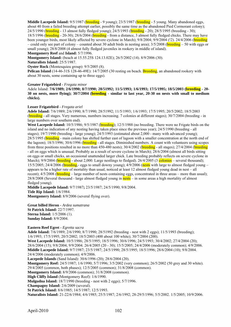
April-2010 102
Middle Lacepede Island: 9/5/1987 (breeding - 9 young); 23/5/1987 (breeding - 5 young. Many abandoned eggs, about 40 from a failed breeding attempt earlier, possibly the same time as the abandoned Pied Cormorant colony); 24/5/1990 (breeding - 13 almost fully fledged young); 24/5/1993 (breeding - 20); 28/5/1995 (breeding - 30); 18/5/1996 (breeding - 20-30); 28/6/2004 (breeding - from a distance, 3 almost fully fledged chicks. There may have been younger birds, most likely affected by severe cyclone in March); 9/8/2004; 9/9/2004 (!2). 24/4/2006 (breeding – could only see part of colony – counted about 30 adult birds in nesting area); 3/5/2008 (breeding – 50 with eggs or small young); 28/8/2008 (4 almost fully fledged juveniles in rookery in middle of island). Montgomery Reef and Island: 5/7/1996. Montgomery Island: (beach at 15.55.25S 124.13.02E); 26/5/2002 (14). 8/9/2006 (30). Naturalists Island: 25/5/1987. Oyster Rock (Montesquieu group): 9/5/2005 (8). Pelican Island (14-46-31S 128-46-49E): 14/7/2005 (30 resting on beach. Breeding, an abandoned rookery with about 30 nests, some containing up to three eggs). Greater Frigatebird - Fregata minor Adele Island: 7/6/1989; 2/6/1990; 8/7/1990; 28/51992; 11/5/1993; 1/6/1993; 17/5/1995; 18/5/2003 (breeding - 20-30 on nests, more flying); 30/7/2004 (breeding - similar to last year, 20-30 on nests with small to medium chicks). Lesser Frigatebird - Fregata ariel Adele Island: 7/6/1989; 2/6/1990; 8/7/1990; 28/51992; 11/5/1993; 1/6/1993; 17/5/1995; 20/5/2002; 18/5/2003 (breeding - all stages. Very numerous, numbers increasing. 7 colonies at different stages); 30/7/2004 (breeding - in large numbers over southern end). West Lacepede Island: 10/5/1986; 9/5/1987 (breeding); 12/5/1988 (no breeding. There were no Frigate birds on the island and no indication of any nesting having taken place since the previous year); 24/5/1990 (breeding - all stages); 19/7/1990 (breeding - large young); 24/5/1993 (estimated about 2,000 - many with advanced young); 28/5/1995 (breeding - main colony has shifted further east of lagoon with a smaller concentration at the north end of the lagoon); 18/5/1996; 30/6/1996 (breeding - all stages. Diminished numbers. A count with volunteers using scopes from three positions resulted in no more than 450-480 nests); 30/4/2002 (breeding - all stages); 27/4/2004 (breeding - all on eggs which is unusual. Probably as a result of severe cyclone in March); 28/6/2004 (almost all birds sitting on eggs or small chicks, an occasional unattended larger chick. Late breeding probably reflects on severe cyclone in March); 9/9/2004 (breeding - about 2,000. Large nestlings to fledged). 26/4/2005 (3 colonies – several thousand); 15/5/2005; 24/4/2006 (breeding,- eggs to small downy young); 4/9/2006 (nests with large to almost fledged young – appears to be a higher rate of mortality than usual, noticed at least 12 almost fledged young dead in nest – all recent); 4/5/2008 (breeding – large number of nests containing eggs, concentrated in three areas – more than usual); 28/8/2008 (Several thousand - large almost fledged young in nests – in some areas a high mortality of almost fledged young). Middle Lacepede Island: 9/7/1987; 23/5/1987; 24/5/1990; 9/8/2004. Tide Rip Island: 1/6/1984. Montgomery Island: 8/9/2006 (several flying over). Great billed Heron - Ardea sumatrana St Patrick Island: 22/7/1997. Sterna Island: 1/5/2006 (1). Sunday Island: 8/9/2004. Eastern Reef Egret - Egretta sacra Adele Island: 7/6/1989; 2/6/1990; 8/7/1990; 28/51992 (breeding - nest with 2 eggs); 11/5/1993 (breeding); 1/6/1993; 17/5/1995; 20/5/2002; 18/5/2003 (400 about 100 white); 30/7/2004 (200). West Lacepede Island: 10/5/1986; 28/5/1995; 18/5/1996; 30/6/1996; 24/5/1993; 30/4/2002; 27/4/2004 (20); 28/6/2004 (15); 9/8/2004; 9/9/2004. 26/4/2005 (20 - 30); 15/5/2005; 24/4/2006 (moderately common); 4/9/2006. Middle Lacepede Island: 9/7/1987; 23/5/1987; 24/5/1990; 28/5/1995; 18/5/1996; 28/6/2004 (10); 9/8/2004. 24/4/2006 (moderately common); 4/9/2006. Lacepede Islands (Sand Island): 30/6/1996 (20); 28/6/2004 (20). Montgomery Reef: 24/5/1987; 1/6/1990; 5/7/1996; 3/5/2002 (very common); 26/5/2002 (50 grey and 30 white). 29/4/2005 (common, both phases); 12/5/2005 (common); 31/8/2008 (common). Montgomery Island: 8/9/2006 (common); 31/8/2008 (common). High Cliffy Island (Montgomery Reef): 1/6/1990. Mulgudna Island: 18/7/1990 (breeding - nest with 2 eggs); 5/7/1996. Champagny Island: 2/6/2009 (several). St Patrick Island: 8/6/1985; 14/5/1987; 12/5/1993. Naturalists Island: 21-22/6/1984; 4/6/1985; 25/5/1987; 2/6/1992; 28-29/5/1996; 5/5/2002. 1/5/2005; 10/9/2006.
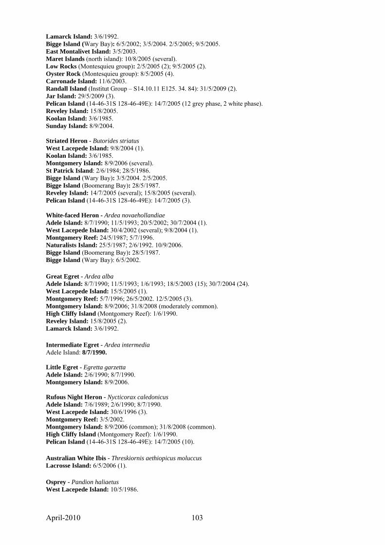
April-2010 103
Lamarck Island: 3/6/1992. Bigge Island (Wary Bay): 6/5/2002; 3/5/2004. 2/5/2005; 9/5/2005. East Montalivet Island: 3/5/2003. Maret Islands (north island): 10/8/2005 (several). Low Rocks (Montesquieu group): 2/5/2005 (2); 9/5/2005 (2). Oyster Rock (Montesquieu group): 8/5/2005 (4). Carronade Island: 11/6/2003. Randall Island (Institut Group – S14.10.11 E125. 34. 84): 31/5/2009 (2). Jar Island: 29/5/2009 (3). Pelican Island (14-46-31S 128-46-49E): 14/7/2005 (12 grey phase, 2 white phase). Reveley Island: 15/8/2005. Koolan Island: 3/6/1985. Sunday Island: 8/9/2004. Striated Heron - Butorides striatus West Lacepede Island: 9/8/2004 (1). Koolan Island: 3/6/1985. Montgomery Island: 8/9/2006 (several). St Patrick Island: 2/6/1984; 28/5/1986. Bigge Island (Wary Bay): 3/5/2004. 2/5/2005. Bigge Island (Boomerang Bay): 28/5/1987. Reveley Island: 14/7/2005 (several); 15/8/2005 (several). Pelican Island (14-46-31S 128-46-49E): 14/7/2005 (3). White-faced Heron - Ardea novaehollandiae Adele Island: 8/7/1990; 11/5/1993; 20/5/2002; 30/7/2004 (1). West Lacepede Island: 30/4/2002 (several); 9/8/2004 (1). Montgomery Reef: 24/5/1987; 5/7/1996. Naturalists Island: 25/5/1987; 2/6/1992. 10/9/2006. Bigge Island (Boomerang Bay): 28/5/1987. Bigge Island (Wary Bay): 6/5/2002. Great Egret - Ardea alba Adele Island: 8/7/1990; 11/5/1993; 1/6/1993; 18/5/2003 (15); 30/7/2004 (24). West Lacepede Island: 15/5/2005 (1). Montgomery Reef: 5/7/1996; 26/5/2002. 12/5/2005 (3). Montgomery Island: 8/9/2006; 31/8/2008 (moderately common). High Cliffy Island (Montgomery Reef): 1/6/1990. Reveley Island: 15/8/2005 (2). Lamarck Island: 3/6/1992. Intermediate Egret - Ardea intermedia Adele Island: 8/7/1990. Little Egret - Egretta garzetta Adele Island: 2/6/1990; 8/7/1990. Montgomery Island: 8/9/2006. Rufous Night Heron - Nycticorax caledonicus Adele Island: 7/6/1989; 2/6/1990; 8/7/1990. West Lacepede Island: 30/6/1996 (3). Montgomery Reef: 3/5/2002. Montgomery Island: 8/9/2006 (common); 31/8/2008 (common). High Cliffy Island (Montgomery Reef): 1/6/1990. Pelican Island (14-46-31S 128-46-49E): 14/7/2005 (10). Australian White Ibis - Threskiornis aethiopicus moluccus Lacrosse Island: 6/5/2006 (1). Osprey - Pandion haliaetus West Lacepede Island: 10/5/1986.
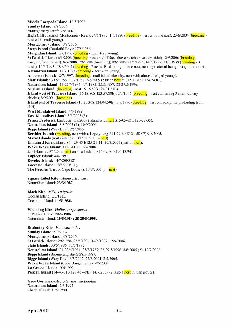
April-2010 104
Middle Lacepede Island: 18/5/1996. Sunday Island: 8/9/2004. Montgomery Reef: 3/5/2002. High Cliffy Island (Montgomery Reef): 24/5/1987; 1/6/1990 (breeding - nest with one egg); 23/6/2004 (breeding - nest with small young). Montgomery Island: 8/9/2006. Steep Island (Doubtful Bay): 17/5/1986. Mulgudna Island: 5/7/1996 (breeding - immature young). St Patrick Island: 6/5/2006 (breeding, nest on cliff face above beach on eastern side); 12/9/2006 (breeding, carrying food to nest); 8/5/2008. 2/6/1984 (breeding); 8/6/1985; 28/5/1986; 14/5/1987; 13/6/1989 (breeding - 3 nests); 12/5/1993; 23/6/2004 (breeding - 2 nests. Bird sitting on one nest, nesting material being brought to other). Keraudren Island: 18/7/1997 (breeding - nest with young). Anderton Island: 18/7/1997. (breeding, small island close by, nest with almost fledged young). Slate Islands: 30/5/1986; 13/7/1987. 3/6/2009 (pair on nest at S15.32.67 E124.24.01). Naturalists Island: 21-22/6/1984; 4/6/1985; 25/5/1987; 28-29/5/1996. Augustus Island: (breeding - nest 15.15.63S 124.31.51E). Island west of Traverse Island (16.13.80S 123.57.80E): 7/9/1996 (breeding - nest containing 3 small downy chicks); 8/9/2004 (breeding). Island east of Traverse Island (16.20.30S 124.04.50E): 7/9/1996 (breeding - nest on rock pillar protruding from cliff). West Montalivet Island: 4/6/1992. East Montalivet Island: 3/5/2003 (3). Prince Frederick Harbour: 6/8/2005 (island with nest S15-05-63 E125-22-05). Naturalists Island: 8/8/2005 (1); 10/9/2006. Bigge Island (Wary Bay): 2/5/2005. Berthier Island: (breeding, nest with a large young S14-29-60 E124-58-07) 9/8/2005. Maret Islands (north island): 10/8/2005 (1+ a nest). Unnamed basalt island S14-29-45 E125-21-11: 10/5/2008 (pair on nest). Woku Woku Island: 11/8/2005; 12/5/2008. Jar Island: 29/5/2009 (nest on small island S14.09.56 E126.13.94). Laplace Island: 4/6/1992. Reveley Island: 14/7/2005 (2). Lacrosse Island: 18/8/2005 (1). The Needles (East of Cape Domett): 18/8/2005 (1+ nest). Square-tailed Kite - Hamirostra isura Naturalists Island: 25/5/1987. Black Kite - Milvus migrans Koolan Island: 3/6/1985. Cockatoo Island: 11/5/1986. Whistling Kite - Haliastur sphenurus St Patrick Island: 28/5/1986. Naturalists Island: 10/6/1984; 28-29/5/1996. Brahminy Kite - Haliastur indus Sunday Island: 8/9/2004. Montgomery Island: 8/9/2006. St Patrick Island: 2/6/1984; 28/5/1986; 14/5/1987. 12/9/2006. Slate Islands: 30/5/1986; 13/5/1987. Naturalists Island: 21-22/6/1984; 25/5/1987; 28-29/5/1996. 8/8/2005 (2); 10/9/2006. Bigge Island (Boomerang Bay): 28/5/1987. Bigge Island (Wary Bay): 6/5/2002; 22/6/2004. 2/5/2005. Woku Woku Island (Cape Bougainville): 9/6/2003. La Crosse Island: 10/6/1992. Pelican Island (14-46-31S 128-46-49E): 14/7/2005 (2, also a nest in mangroves). Grey Goshawk - Accipiter novaehollandiae Naturalists Island: 2/6/1992. Sheep Island: 31/5/1990.
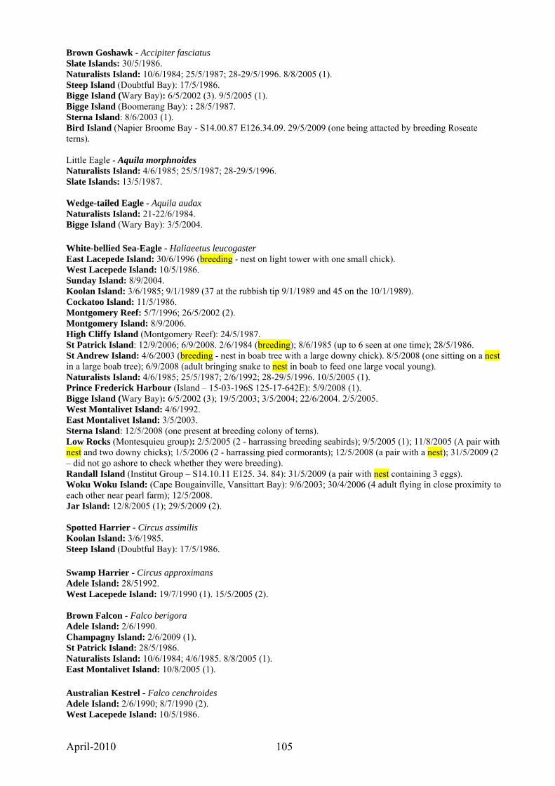
April-2010 105
Brown Goshawk - Accipiter fasciatus Slate Islands: 30/5/1986. Naturalists Island: 10/6/1984; 25/5/1987; 28-29/5/1996. 8/8/2005 (1). Steep Island (Doubtful Bay): 17/5/1986. Bigge Island (Wary Bay): 6/5/2002 (3). 9/5/2005 (1). Bigge Island (Boomerang Bay): : 28/5/1987. Sterna Island: 8/6/2003 (1). Bird Island (Napier Broome Bay - S14.00.87 E126.34.09. 29/5/2009 (one being attacted by breeding Roseate terns). Little Eagle - Aquila morphnoides Naturalists Island: 4/6/1985; 25/5/1987; 28-29/5/1996. Slate Islands: 13/5/1987. Wedge-tailed Eagle - Aquila audax Naturalists Island: 21-22/6/1984. Bigge Island (Wary Bay): 3/5/2004. White-bellied Sea-Eagle - Haliaeetus leucogaster East Lacepede Island: 30/6/1996 (breeding - nest on light tower with one small chick). West Lacepede Island: 10/5/1986. Sunday Island: 8/9/2004. Koolan Island: 3/6/1985; 9/1/1989 (37 at the rubbish tip 9/1/1989 and 45 on the 10/1/1989). Cockatoo Island: 11/5/1986. Montgomery Reef: 5/7/1996; 26/5/2002 (2). Montgomery Island: 8/9/2006. High Cliffy Island (Montgomery Reef): 24/5/1987. St Patrick Island: 12/9/2006; 6/9/2008. 2/6/1984 (breeding); 8/6/1985 (up to 6 seen at one time); 28/5/1986. St Andrew Island: 4/6/2003 (breeding - nest in boab tree with a large downy chick). 8/5/2008 (one sitting on a nest in a large boab tree); 6/9/2008 (adult bringing snake to nest in boab to feed one large vocal young). Naturalists Island: 4/6/1985; 25/5/1987; 2/6/1992; 28-29/5/1996. 10/5/2005 (1). Prince Frederick Harbour (Island – 15-03-196S 125-17-642E): 5/9/2008 (1). Bigge Island (Wary Bay): 6/5/2002 (3); 19/5/2003; 3/5/2004; 22/6/2004. 2/5/2005. West Montalivet Island: 4/6/1992. East Montalivet Island: 3/5/2003. Sterna Island: 12/5/2008 (one present at breeding colony of terns). Low Rocks (Montesquieu group): 2/5/2005 (2 - harrassing breeding seabirds); 9/5/2005 (1); 11/8/2005 (A pair with nest and two downy chicks); 1/5/2006 (2 - harrassing pied cormorants); 12/5/2008 (a pair with a nest); 31/5/2009 (2 – did not go ashore to check whether they were breeding). Randall Island (Institut Group – S14.10.11 E125. 34. 84): 31/5/2009 (a pair with nest containing 3 eggs). Woku Woku Island: (Cape Bougainville, Vansittart Bay): 9/6/2003; 30/4/2006 (4 adult flying in close proximity to each other near pearl farm); 12/5/2008. Jar Island: 12/8/2005 (1); 29/5/2009 (2). Spotted Harrier - Circus assimilis Koolan Island: 3/6/1985. Steep Island (Doubtful Bay): 17/5/1986. Swamp Harrier - Circus approximans Adele Island: 28/51992. West Lacepede Island: 19/7/1990 (1). 15/5/2005 (2). Brown Falcon - Falco berigora Adele Island: 2/6/1990. Champagny Island: 2/6/2009 (1). St Patrick Island: 28/5/1986. Naturalists Island: 10/6/1984; 4/6/1985. 8/8/2005 (1). East Montalivet Island: 10/8/2005 (1). Australian Kestrel - Falco cenchroides Adele Island: 2/6/1990; 8/7/1990 (2). West Lacepede Island: 10/5/1986.
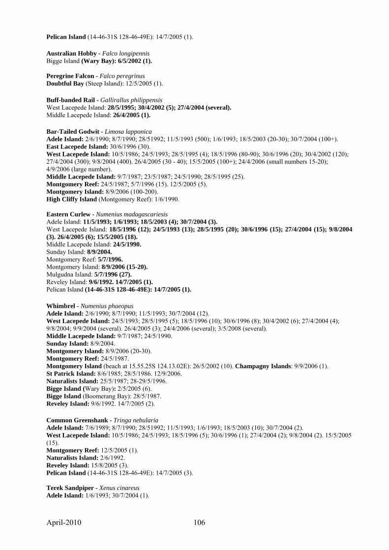
April-2010 106
Pelican Island (14-46-31S 128-46-49E): 14/7/2005 (1). Australian Hobby - Falco longipennis Bigge Island (Wary Bay): 6/5/2002 (1). Peregrine Falcon - Falco peregrinus Doubtful Bay (Steep Island): 12/5/2005 (1). Buff-banded Rail - Gallirallus philippensis West Lacepede Island: 28/5/1995; 30/4/2002 (5); 27/4/2004 (several). Middle Lacepede Island: 26/4/2005 (1). Bar-Tailed Godwit - Limosa lapponica Adele Island: 2/6/1990; 8/7/1990; 28/51992; 11/5/1993 (500); 1/6/1993; 18/5/2003 (20-30); 30/7/2004 (100+). East Lacepede Island: 30/6/1996 (30). West Lacepede Island: 10/5/1986; 24/5/1993; 28/5/1995 (4); 18/5/1996 (80-90); 30/6/1996 (20); 30/4/2002 (120); 27/4/2004 (300); 9/8/2004 (400). 26/4/2005 (30 - 40); 15/5/2005 (100+); 24/4/2006 (small numbers 15-20); 4/9/2006 (large number). Middle Lacepede Island: 9/7/1987; 23/5/1987; 24/5/1990; 28/5/1995 (25). Montgomery Reef: 24/5/1987; 5/7/1996 (15). 12/5/2005 (5). Montgomery Island: 8/9/2006 (100-200). High Cliffy Island (Montgomery Reef): 1/6/1990. Eastern Curlew - Numenius madagascariesis Adele Island: 11/5/1993; 1/6/1993; 18/5/2003 (4); 30/7/2004 (3). West Lacepede Island: 18/5/1996 (12); 24/5/1993 (13); 28/5/1995 (20); 30/6/1996 (15); 27/4/2004 (15); 9/8/2004 (3). 26/4/2005 (6); 15/5/2005 (18). Middle Lacepede Island: 24/5/1990. Sunday Island: 8/9/2004. Montgomery Reef: 5/7/1996. Montgomery Island: 8/9/2006 (15-20). Mulgudna Island: 5/7/1996 (27). Reveley Island: 9/6/1992. 14/7/2005 (1). Pelican Island (14-46-31S 128-46-49E): 14/7/2005 (1). Whimbrel - Numenius phaeopus Adele Island: 2/6/1990; 8/7/1990; 11/5/1993; 30/7/2004 (12). West Lacepede Island: 24/5/1993; 28/5/1995 (5); 18/5/1996 (10); 30/6/1996 (8); 30/4/2002 (6); 27/4/2004 (4); 9/8/2004; 9/9/2004 (several). 26/4/2005 (3); 24/4/2006 (several); 3/5/2008 (several). Middle Lacepede Island: 9/7/1987; 24/5/1990. Sunday Island: 8/9/2004. Montgomery Island: 8/9/2006 (20-30). Montgomery Reef: 24/5/1987. Montgomery Island (beach at 15.55.25S 124.13.02E): 26/5/2002 (10). Champagny Islands: 9/9/2006 (1). St Patrick Island: 8/6/1985; 28/5/1986. 12/9/2006. Naturalists Island: 25/5/1987; 28-29/5/1996. Bigge Island (Wary Bay): 2/5/2005 (6). Bigge Island (Boomerang Bay): 28/5/1987. Reveley Island: 9/6/1992. 14/7/2005 (2). Common Greenshank - Tringa nebularia Adele Island: 7/6/1989; 8/7/1990; 28/51992; 11/5/1993; 1/6/1993; 18/5/2003 (10); 30/7/2004 (2). West Lacepede Island: 10/5/1986; 24/5/1993; 18/5/1996 (5); 30/6/1996 (1); 27/4/2004 (2); 9/8/2004 (2). 15/5/2005 (15). Montgomery Reef: 12/5/2005 (1). Naturalists Island: 2/6/1992. Reveley Island: 15/8/2005 (3). Pelican Island (14-46-31S 128-46-49E): 14/7/2005 (3). Terek Sandpiper - Xenus cinareus Adele Island: 1/6/1993; 30/7/2004 (1).
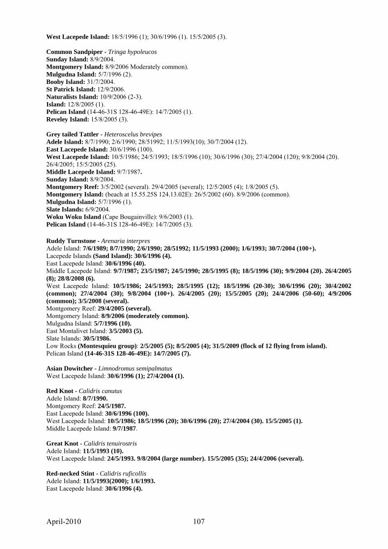
April-2010 107
West Lacepede Island: 18/5/1996 (1); 30/6/1996 (1). 15/5/2005 (3). Common Sandpiper - Tringa hypoleucos Sunday Island: 8/9/2004. Montgomery Island: 8/9/2006 Moderately common). Mulgudna Island: 5/7/1996 (2). Booby Island: 31/7/2004. St Patrick Island: 12/9/2006. Naturalists Island: 10/9/2006 (2-3). Island: 12/8/2005 (1). Pelican Island (14-46-31S 128-46-49E): 14/7/2005 (1). Reveley Island: 15/8/2005 (3). Grey tailed Tattler - Heteroscelus brevipes Adele Island: 8/7/1990; 2/6/1990; 28/51992; 11/5/1993(10); 30/7/2004 (12). East Lacepede Island: 30/6/1996 (100). West Lacepede Island: 10/5/1986; 24/5/1993; 18/5/1996 (10); 30/6/1996 (30); 27/4/2004 (120); 9/8/2004 (20). 26/4/2005; 15/5/2005 (25). Middle Lacepede Island: 9/7/1987. Sunday Island: 8/9/2004. Montgomery Reef: 3/5/2002 (several). 29/4/2005 (several); 12/5/2005 (4); 1/8/2005 (5). Montgomery Island: (beach at 15.55.25S 124.13.02E): 26/5/2002 (60). 8/9/2006 (common). Mulgudna Island: 5/7/1996 (1). Slate Islands: 6/9/2004. Woku Woku Island (Cape Bougainville): 9/6/2003 (1). Pelican Island (14-46-31S 128-46-49E): 14/7/2005 (3). Ruddy Turnstone - Arenaria interpres Adele Island: 7/6/1989; 8/7/1990; 2/6/1990; 28/51992; 11/5/1993 (2000); 1/6/1993; 30/7/2004 (100+). Lacepede Islands (Sand Island): 30/6/1996 (4). East Lacepede Island: 30/6/1996 (40). Middle Lacepede Island: 9/7/1987; 23/5/1987; 24/5/1990; 28/5/1995 (8); 18/5/1996 (30); 9/9/2004 (20). 26/4/2005 (8); 28/8/2008 (6). West Lacepede Island: 10/5/1986; 24/5/1993; 28/5/1995 (12); 18/5/1996 (20-30); 30/6/1996 (20); 30/4/2002 (common); 27/4/2004 (30); 9/8/2004 (100+). 26/4/2005 (20); 15/5/2005 (20); 24/4/2006 (50-60); 4/9/2006 (common); 3/5/2008 (several). Montgomery Reef: 29/4/2005 (several). Montgomery Island: 8/9/2006 (moderately common). Mulgudna Island: 5/7/1996 (10). East Montalivet Island: 3/5/2003 (5). Slate Islands: 30/5/1986. Low Rocks (Montesquieu group): 2/5/2005 (5); 8/5/2005 (4); 31/5/2009 (flock of 12 flying from island). Pelican Island (14-46-31S 128-46-49E): 14/7/2005 (7). Asian Dowitcher - Limnodromus semipalmatus West Lacepede Island: 30/6/1996 (1); 27/4/2004 (1). Red Knot - Calidris canutus Adele Island: 8/7/1990. Montgomery Reef: 24/5/1987. East Lacepede Island: 30/6/1996 (100). West Lacepede Island: 10/5/1986; 18/5/1996 (20); 30/6/1996 (20); 27/4/2004 (30). 15/5/2005 (1). Middle Lacepede Island: 9/7/1987. Great Knot - Calidris tenuirostris Adele Island: 11/5/1993 (10). West Lacepede Island: 24/5/1993. 9/8/2004 (large number). 15/5/2005 (35); 24/4/2006 (several). Red-necked Stint - Calidris ruficollis Adele Island: 11/5/1993(2000); 1/6/1993. East Lacepede Island: 30/6/1996 (4).

April-2010 108
West Lacepede Island: 10/5/1986; 24/5/1993; 28/5/1995 (8); 18/5/1996 (40); 30/6/1996 (25); 27/4/2004 (50); 9/8/2004 (60+). 15/5/2005 (8). Middle Lacepede Island: 9/7/1987. Montgomery Reef: 12/5/2005 (10). Mulgudna Island: 5/7/1996 (20). Slate Islands: 30/5/1986. East Montalivet Island: 10/8/2005 (5). Reveley Island: 15/8/2005 (30). Pelican Island (14-46-31S 128-46-49E): 14/7/2005 (5). Sharp-tailed Sandpiper - Calidris acuminata Adele Island: 1/6/1993. Montgomery Reef: 24/5/1987. Curlew Sandpiper - Calidris ferruginea Adele Island: 30/7/2004 (2). Montgomery Reef: 24/5/1987. West Lacepede Island: 24/5/1993; 18/5/1996 (1); 27/4/2004 (2). 15/5/2005 (8). Middle Lacepede Island: 9/7/1987. Beach Stone-Curlew - Esacus neglectus Middle Lacepede Island: 24/5/1990. Montgomery Island: (beach at 15.55.25S 124.13.02E): 26/5/2002 (1). 8/9/2006 (2). High Cliffy Island: 24/6/2004. Sheep Island: 31/5/1992. Champagny Islands: 9/9/2006 (1). Slate Islands (N): 6/5/2008 (3); 3/6/2009 (2 pair – lots of flatback turtles hatching). Naturalists Island: 28-29/5/1996; 5/5/2002; 1/8/2004. 8/8/2005 (2); 10/5/2008. Slate Islands: 13/5/1987. Prince Frederick Harbour (Island – 15-03-196S 125-17-642E): 5/9/2008 (2). Bigge Island (Wary Bay): 6/5/2002; 21/6/2004. Queen Island (opposite Bigge Island): 3/9/2008 (2 on turtle beach). East Montalivet Island: 3/5/2003 (3). Carronade Island: 11/6/2003. Woku Woku Island (Cape Bougainville): 9/6/2003 (3). Laplace Island: 4/6/1992. La Crosse Island: 10/6/1992. Woku Woku Island: 2/5/2006 (2- south end near maccassan site); Reveley Island: 14/7/2005 (2). Lacrosse Island: 18/8/2005 (2); 6/5/2006 (1). Pelican Island (14-46-31S 128-46-49E): 14/7/2005 (2). Pied Oystercatcher - Haematopus longirostris Adele Island: 7/6/1989; 8/7/1990; 28/51992; 11/5/1993; 18/5/2003; 30/7/2004 (6). Lacepede Islands (Sand Island): 30/6/1996 (12). East Lacepede Island: 30/6/1996 (2). West Lacepede Island: 10/5/1986; 24/5/1993; 28/5/1995; 18/5/1996 (4); 30/6/1996. 30/4/2002 (4); 27/4/2004 (8); 9/8/2004 (6); 9/9/2004 (1). 26/4/2005 (5); 15/5/2005 (10); 24/4/2006 (9); 4/9/2006. Middle Lacepede Island: 9/7/1987; 23/5/1987; 24/5/1990; 28/5/1995; 18/5/1996 (4); 28/6/2004 (2). 4/9/2006; 28/8/2008 (2). Turtle Reef (near northern entrance to Talbot Bay): 6/6/2009 (several). Montgomery Reef: 24/5/1987; 5/7/1996 (4). 12/5/2005 (3); 31/8/2008 (several). Montgomery Island: (beach at 15.55.25S 124.13.02E): 26/5/2002 (23). 8/9/2006 (about 10. – Breeding, one egg on beach); 31/8/2008 (two with a small fluffy chick). Naturalists Island: 21-22/6/1984; 4/6/1985; 25/5/1987; 2/6/1992. Slate Islands: 30/5/1986; 6/9/2004. Prince Frederick Harbour (Island – 15-03-196S 125-17-642E): 5/9/2008 (2). Prince Frederick Harbour (Island – 15-04-767S 125-20-537E): 5/9/2008 (3). Bigge Island (Boomerang Bay): 28/5/1987. East Montalivet Island: 3/5/2003. Maret Islands (north island): 10/8/2005 (3). Palm Island (Swift Bay): 11/5/2008 (2).

April-2010 109
Woku Woku Island: 9/6/2003 (2). 11/8/2005 (breeding, nest with 2 freshly laid eggs); 12/5/2008 (2). Carronade Island: 11/6/2003. Reveley Island: 9/6/1992. 15/8/2005 (3). Randall Island (Institut Group – S14.10.11 E125. 34. 84): 31/5/2009 (4). Pelican Island (14-46-31S 128-46-49E): 14/7/2005 (4). Sooty Oystercatcher - Haematopus fuliginosus Middle Lacepede Island: 9/7/1987; 23/5/1987; 24/5/1990; 28/5/1995; 18/5/1996 (6); 28/6/2004 (4); 9/8/2004 (2). 4/9/2006. West Lacepede Island: 10/5/1986; 24/5/1993; 28/5/1995; 18/5/1996 (6); 30/6/1996; 30/4/2002 (12); 27/4/2004 (15). Lacepede Islands (Sand Island): 30/6/1996 (12). Mulgudna Island: 5/7/1996 (3). Montgomery Reef: 24/5/1987; 5/6/1996 (6). 1/8/2005 (6). Montgomery Island: 8/9/2006 (5-6). Slate Islands: 6/5/2008 (2). Camden harbour (Sheep Island): 7/5/2008 (2). Champagny Islands: 9/9/2006 (1). Naturalists Island: 21-22/6/1984; 25/5/1987. Prince Frederick Harbour (Island – 15-04-767S 125-20-537E): 5/9/2008 (1). Bigge Island (Wary Bay): 6/5/2002; 21/6/2004. 2/5/2005 (1). Bigge Island (Boomerang Bay): 28/5/1987. East Montilivet Island: 3/5/2003. Carronade Island: 11/6/2003. Woku Woku Island (Cape Bougainville): 9/6/2003 (1). Laplace Island: 4/6/1992. Steep Island (Doubtful Bay): 17/5/1986. Slate Islands: 30/5/1986; 6/9/2004. Jar Island: 29/5/2009 (2). Reveley Island: 14/7/2005 (2). Pelican Island (14-46-31S 128-46-49E): 14/7/2005 (2). Grey Plover - Pluvialis squatarola Adele Island: 8/7/1990; 2/6/1990; 30/7/2004 (2). East Lacepede Island: 30/6/1996 (30). West Lacepede Island: 10/5/1986; 28/5/1995 (5); 18/5/1996 (10); 30/6/1996 (4); 9/8/2004 (2). 15/5/2005 (12); 24/4/2006 (30 - 40); 4/9/2006 (100+). Middle Lacepede Island: 18/5/1996. Montgomery Island: 8/9/2006 (flock of about 60). Reveley Island: 9/6/1992. Pacific Golden Plover - Pluvialis fulva Adele Island: 7/6/1989. West Lacepede Island: 24/5/1993; 30/6/1996 (1); 30/4/2002 (20); 9/8/2004 (several). 26/4/2005; 15/5/2005 (4). Carronade Island: 11/6/2003 Red-capped Plover - Charadrius ruficapillus Adele Island: 7/6/1989; 8/7/1990; 11/5/1993 (5); 18/5/2003 (2). West Lacepede Island: 10/5/1986; 24/5/1993; 18/5/1996 (16); 30/6/1996 (2); 9/8/2004 (100+). 15/5/2005 (25); 3/5/2008 (8-10). Middle Lacepede Island: 24/5/1990. Slate Islands: 30/5/1986; 6/9/2004 (breeding - one nest with 2 eggs and two adults with newly hatched young 1+2). Champagny Islands: 9/9/2006 (2). East Montalivet Island: 10/8/2005 (5). West Montalivet Island: 4/6/1992. Sterna Island: 8/6/2003 (3). Woku Woku Island (Cape Bougainville): 9/6/2003 (6). Carronade Island: 11/6/2003. Laplace Island: 4/6/1992. Reveley Island: 9/6/1992. 14/7/2005 (3); 15/8/2005; (20). Lacrosse Island: 6/5/2006 (several). Pelican Island (14-46-31S 128-46-49E): 14/7/2005 (15).
April-2010 110
Lesser Sand Plover - Charadrius mongolus East Lacepede Island: 30/6/1996 (10). West Lacepede Island: 10/5/1986; 24/5/1993; 28/5/1995 (4); 18/5/1996 (6); 30/6/1996 (3); 30/4/2002 (20); 27/4/2004 (40); 9/8/2004 (reasonably common). 24/5/1993; 18/5/1996 (4); 9/8/2004 (reasonably common). Middle Lacepede Island: 24/5/1990. 24/5/1990. Montgomery Reef: 5/7/1996 (30). Montgomery Island (beach at 15.55.25S 124.13.02E): 26/5/2002 (12). Mulgudna Island: 5/7/1996 (200). Reveley Island: 15/8/2005; (25). Pelican Island (14-46-31S 128-46-49E): 14/7/2005 (20). Greater Sand Plover - Charadrius leschenaultii Adele Island: 11/5/1993 (10). West Lacepede Island: 3/5/2008 (5). Montgomery Reef: 7/8/2004. 12/5/2005 (4). Mulgudna Island: 5/7/1996 (200). Slate Islands: 6/9/2004. Reveley Island: 9/6/1992. 15/8/2005 (2). Pelican Island (14-46-31S 128-46-49E): 14/7/2005 (54). Australian Pratincole - Stiltia isabella Adele Island: 2/6/1990; 8/7/1990. Naturalists Island: 21-22/6/1984; 28-29/5/1996. Pacific Gull - Larus pacificus West Lacepede Island: 10/5/1986 (unusual record). Silver Gull - Larus novaehollandiae Adele Island: 7/6/1989; 8/7/1990; 2/6/1990; 28/51992; 11/5/1993; 1/6/1993; 17/5/1995; 20/5/2002 (26); 18/5/2003 (30); 30/7/2004 (30). East Lacepede Island: 30/6/1996 (20). Middle Lacepede Island: 9/5/1987; 23/5/1987; 28/5/1995; 18/5/1996; 28/6/2004 (40); 9/8/2004 (30); 9/9/2004 (30-40). 26/4/2005 (60-70 scattered through Brown Booby breeding area); 24/4/2006 (common – at two sites observed about 20 clustered around and feeding on emerging turtle hatchlings); 4/9/2006 (small number); 3/5/2008 (50-60, very little interest was shown in our presence which was unusual, it may have had something to do with the lateness of the day); 28/8/2008 (50-60). West Lacepede Island: 10/5/1986; 9/5/1987; 19/7/1990; 24/5/1993; 28/5/1995 (breeding - immatures and runners); 18/5/1996 breeding - runners); 30/6/1996 (40); 30/4/2002 (1500-2000 - also breeding); 27/4/2004 (70); 28/6/2004 (50); 9/8/2004 (30); 9/9/2004 (30-40). 26/4/2005 (breeding – large runners and immature eastern end); 15/5/2005 (many recently fledged); 24/4/2006 (common); 4/9/2006 (small number); 3/5/2008 (50-60, as on Middle Island very little interest was shown in our presence which was unusual, it may have had something to do with the lateness of the day); 28/8/2008 (50-60). Lacepede Islands (Sand Island): 30/6/1996 (20); 28/6/2004 (25 - not predating). Sunday Island: 8/9/2004. Cockatoo Island: 11/5/1986. Montgomery Reef: 24/5/1987. 29/4/2005 (several). Montgomery Island (beach at 15.55.25S 124.13.02E): 26/5/2002 (20). Naturalists Island: 21-22/6/1984. Low Rocks (Montesquieu group): 2/5/2005 (4); 9/5/2005 (2). Randall Island (Institut Group – S14.10.11 E125. 34. 84): 31/5/2009 (10). Gull-billed Tern - Sterna nilotica Adele Island: 2/6/1990; 20/5/2002 (6); 30/7/2004 (16). West Lacepede Island: 10/5/1986; 19/7/1990; 24/5/1993; 28/5/1995 (3); 30/6/1996 (20); 9/8/2004 (6). 15/5/2005 (15); 26/4/2006 (40–50). Middle Lacepede Island: 24/5/1990. Pelican Island (14-46-31S 128-46-49E): 14/7/2005 (60). Caspian Tern - Sterna caspia

April-2010 111
Adele Island: 7/6/1989; 2/6/1990; 8/7/1990; 28/51992; 11/5/1993; 1/6/1993; 17/5/1995; 20/5/2002; 18/5/2003; 30/7/2004 (10). West Lacepede Island: 10/5/1986; 24/5/1990 (breeding - a tight group of 70 on eggs); 20/7/1990 (breeding); 24/5/1993 (breeding - 40 in two colonies of about 20. About 110 in breeding plumage nearby ready to go down); 28/5/1995 (breeding - 25); 18/5/1996 (breeding colony SW end of lagoon); 30/6/1996 (breeding - 25 nests + runners from previous hatchings in the vicinity); 30/4/2002 (a concentration of Roseate Tern and Caspian Tern could be seen at the western end of lagoon - possibly breeding); 30/4/2002 (10); 28/6/2004 (breeding - two colonies 50m apart on eggs [22 nests in one and 20 in the other]); 9/8/2004 (10-15); 27/4/2004 (30); 9/9/2004 (15 + several fledged young). 26/4/2005 (15 - 20); 15/5/2005 (40); 26/4/2006 (2); 3/5/2008 (breeding, about 20 on the western end of lagoon). Middle Lacepede Island: 9/7/1987. Montgomery Reef: 24/5/1987; 3/5/2002; 7/8/2004. 29/4/2005 (several); 12/5/2005. Montgomery Island: (beach at 15.55.25S 124.13.02E): 26/5/2002 (40). 8/9/2006 (15-20). High Cliffy Island (Montgomery Reef): 1/6/1990. Mulgudna Island: 18/7/1990 (breeding - one pair with 2 eggs). Crested Tern - Sterna bergii Adele Island: 7/6/1989; 2/6/1990; 8/7/1990; 11/5/1993; 1/6/1993; 17/5/1995; 20/5/2002 (breeding - southern end of island); 18/5/2003; 30/7/2004 (100+). West Lacepede Island: 10/5/1986; 24/5/1993 (75); 27/4/2004 (20); 28/6/2004 (breeding - 31 nests with eggs abutting a breeding colony of Caspian Tern); 9/8/2004 (100+); 9/9/2004 (several hundred). 26/4/2005 (10); 15/5/2005 (50); 26/4/2006 (common); 4/9/2006 (about 300); 3/5/2008 (several); 28/8/2008 (100+); 3/5/2009 (breeding 300 on eggs). Middle Lacepede Island: 9/7/1987; 23/5/1987; 24/5/1990. Sunday Island: 8/9/2004. Montgomery Reef: 24/5/1987; 5/7/1996; 3/5/2002; 7/8/2004. 29/4/2005; 12/5/2005. Montgomery Island: (beach at 15.55.25S 124.13.02E): 26/5/2002 (30). 8/9/2006 (common). High Cliffy Island: 1/6/1990. Mulgudna Island: 5/7/1996 (20). St Patrick Island: 8/6/1985; 28/5/1986. Slate Islands: 30/5/1986. Naturalists Island: 8/6/1985; 31/5/1986. 10/9/2006 (several); 10/5/2008. Bigge Island (Boomerang Bay): 28/5/1987. Bigge Island (Wary Bay): 6/5/2002; 3/5/2004; 21/6/2004 (large number with Roseate Tern, southern end of island - may be a breeding island in vicinity). ): 2/5/2005 (several); 9/5/2005. East Montalivet Island: 3/5/2003 (6). Low Rocks (Montesquieu group): 2/5/2005 (breeding, 50-100 on eggs, up from the beach amongst Ipomaea macrantha). 9/5/2005 (2500+ breeding on beach above high water on southern end, south west beach and in vegetation on island above south western beach and in vegetation on the northern end. All with one freshly laid egg. Many eggs on sand in front of cave containing a large crocodile; 11/8/2005 (Most birds had finished breeding and left, however there were still several thousand tern including 300-400 almost fledged runners on the island); 1/5/2006 (none breeding on Low Rocks). Sterna Island: 1/5/2006 (breeding, about 1,500 on freshly laid eggs). Colony appeared to have only just become established and is in the process of expanding. Predation on about 14 freshly laid eggs, some of which had been brought to a central place, most likely by a heron. A great billed Heron was present on our arrival and flew to the beach of a nearby island. There was no sign of raptors or silver gulls; 12/5/2008 (breeding, about 3,000 on freshly laid eggs). 4 eggs freshly predated, possibly by heron. One white bellied sea-eagle at the breeding site but no evidence of silver gulls. Ashore at 6am. Randall Island (Institut Group – S14.10.11 E125. 34. 84): 31/5/2009 (breeding, 4 colonies approx 2,000. Eggs freshly laid to several newly hatched chicks. Many (100s) old intact abandoned eggs from previous breeding. Nests with eggs on southern end and west side of main island. On east side a colony of about 300 with some newly hatched chicks. Nesting amongst Roseate Terns on western extension of island. Very heavy predation of hundreds of fresh eggs evident, most probably gulls, oystercatchers or herons. A pair of White bellied Sea eagles have a nest containing 3 eggs on the island. Jar Island: 29/5/2009 (20-30 roosting). Carronade Island: 11/6/2003. Bird Island (Napier Broome Bay - S14.00.87 E126.34.09): 29/5/2009 (breeding on coral shingle with a few nests in beach spinifex, 40 nests with eggs + several small downy runners. Old eggs from previous breeding scattered over island. Three crocodiles at island. Aunt Island: 14/7/2005 (breeding, 1000+); 17/8/2005 (several hundred immature birds roosting on rocks at northern end); 21/5/2009 (breeding). Pelican Island (14-46-31S 128-46-49E): 14/7/2005 (one dead bird on beach).
April-2010 112
Lesser Crested Tern - Sterna bengalensis Adele Island: 7/6/1989; 2/6/1990; 28/51992; 11/5/1993; 1/6/1993; 17/5/1995; 18/5/2003. West Lacepede Island: 24/5/1993; 18/5/1996. Cockatoo Island: 11/5/1986. Tide Rip Island: June 1984. Low Rocks (Montesquieu group): 9/5/2005 (breeding, several hundred all with one freshly laid egg, mixed amongst breeding Crested Tern); 11/8/2005 (Most birds had finished breeding and left, however there was a small number of dependent, almost fledged runners still on the island (about 7-10). Sterna Island: 12/5/2008 (breeding, 800-1000 on freshly laid eggs in small groups amongst crested terns. Randall Island (Institut Group – S14.10.11 E125. 34. 84): 31/5/2009 (breeding, approx 30 amongst Crested Terns. Roseate Tern - Sterna dougallii Adele Island: 2/6/1990; 20/5/2002; 30/7/2004 (20). East Lacepede Island: 30/6/1996 (20). Middle Lacepede Island: 26/4/2005 (several small flocks of about eight flying past). West Lacepede Island: 19/7/1990 (several thousand roosting); 24/5/1993 (breeding); 28/5/1995; 4/5/1996 (flocks up to 200 feeding on bait fish between the Lacepede Islands and mainland); 18/5/1996 (2 - large flocks at sea close to island); 30/6/1996 (breeding - 20 nests + runners); 30/4/2002 (a concentration of Roseate Tern and Caspian Tern could be seen at the western end of lagoon - possibly breeding); 27/4/2004 (15); 9/8/2004 (many thousands flying to island to roost); 9/9/2004 (between 10,000 and 15,000 roosting in lagoon area). 26/4/2005 (several small flocks); 15/5/2005 (8); 26/4/2006 (3 to 4,000 roosting at sunset in lagoon area); 4/9/2006 (10,000 to 15,000 roosting on sand bar in lagoon area at sunset with many more flocks of 30-40 still arriving as we left): 3/5/2008 (1,000 +). Sand Island (Lacepedes): 3/5/2008 (several thousand flying in flocks of 15 to 30 across West and Middle Lacepede islands towards Sand Island at sundown; 28/8/2008 (several thousand flying in flocks of 10 to 80 across West and Middle Lacepede islands towards Sand Island at sundown.. Sunday Island: 14/5/1996 (flocks of a 100 or more feeding); 1/7/1996 (small flocks flying in southerly direction); 8/9/2004. Montgomery Reef: 29/4/2005 (several small flocks 6-8); 12/5/2005 (several small flocks). Bigge Island (southern end); 21/6/2004 (many hundreds feeding on bait fish with Crested Tern. Possibly a breeding colony in vicinity). Low Rocks (Montesquieu group): 2/5/2005 (breeding, 1000 to 1500, all with one newly laid egg, concentrated on sand just above high tide mark on south beach and on adjacent rock ledges); 9/5/2005 (breeding, estimated at about 4000 +. Nesting on rocks, amongst Ipomoea macrantha vines and amongst Spinifex longifolius over much of the island. Earlier nesting site on sand above high tide mark on south beach displaced by Crested Tern; 11/8/2005 (A small number still on island bringing food to about 20-30 dependent juveniles capable of flying short distances. In the breeding areas there were many dried out remains of young birds from freshly hatched to fledged); 1/5/2006 (no birds at Low Rocks, the colony has returned to Sterna Island); 31/5/2009 (several small flocks roosting on rocks and flying toward Long Reef – low tide. Water Temperature 28.7 degree). Sterna Island: 1/5/2006 (breeding, 5,000 to 6,000 on freshly laid eggs (1-3). An area abutting the main colony had about 1,000 birds with no eggs as yet laid. Colony appeared to have only just established and is in the process of expanding with much courtship taking place. Many of the birds with roseate chests. Predation on some freshly laid eggs, most likely by a heron. A great billed Heron was present and flew to the beach on a nearby island. Unusual to see this bird which is usually associated more with tidal inlets and mangrove areas. There was no sign of raptors or silver gulls; 12/5/2008 (breeding, 1500-2000 on freshly laid eggs). Breeding just beginning, probably many more will arrive during the week. Randall Island (Institut Group – S14.10.11 E125. 34. 84): 31/5/2009 (breeding, 5 colonies approx 6-8,000. Eggs freshly laid to several newly hatched chicks. Many old abandoned eggs from previous year. Nests amongst and on top of vines and grass and amongst beach spinifex in centre of island and on shell gritty openings amongst basalt rocks on western arms of the island. Nests contained one to three eggs. Some predation of fresh eggs but not much. Ten silver gulls on the beach on our arrival but they disappeared soon after and were not seen again. Water Temperature 30.4 degree). Bird Island (Napier Broome Bay - S14.00.87 E126.34.09. The small sandy island which has a few low rocks of sandstone over it is of about two acres and apart from a small area of shrubbery on the east side is covered almost entirely with beach spinifex about half a metre in height which is not dense and easy to walk through): 29/5/2009 (breeding mainly in beach spinifex, 800-1000 with eggs + small downy young. Old eggs from previous breeding scattered over island. By their tracks the three crocodiles resident at island move through the colony. A large female Goshawk was present at time of landing and being attacked by the terns. A dead Roseate chick had been pecked around the head. Hermit crabs which are plentiful were feeding on another dead chick. Common Tern - Sterna hirundo West Lacepede Island: 30/6/1996 (1).
April-2010 113
Little Tern - Sterna albifrons Adele Island: 30/7/2004 (2). West Lacepede Island: 10/5/1986; 24/5/1993 (350); 28/5/1995 (50); 18/5/1996 (50); 30/6/1996 (200); 27/4/2004 (120); 9/8/2004 (2). Middle Lacepede Island: 24/5/1990. Sunday Island: 1/7/1996 (small numbers flying in southerly direction). Montgomery Island: 8/9/2006 (flock of about 15). Mulgudna Island: 5/7/1996 (breeding). Bridled Tern - Sterna anaethetus Middle Lacepede Island: 28/8/2008 (70-80 loafing on beach). West Lacepede Island: 24/4/2006 (15-20). Low Rocks (Montesquieu group): 2/5/2005 (breeding, about 20-30). 9/5/2005 (breeding, about 20 observed flying into rock crevices). Common Noddy - Anous stolidus Adele Island: 7/6/1989; 28/51992; 11/5/1993; 20/5/2002; 30/7/2004 (240). Lacepede Islands: 9/9/2004 (several close inshore to Middle Island flying in the direction of Sand Island). Middle Lacepede Island: 9/7/1987; 23/5/1987 (breeding - eggs, apart from some small chicks. Colony estimated to cover more than an acre); 24/5/1990; 28/5/1995; 9/9/2004 (several thousand roosting here and on West Island). 26/4/2005 (several hundred roosting on beach); 24/4/2006 (at least 1,000 roosting at sunset); 3/5/2008 (about 400); 28/8/2008 (3-400 loafing on beach). West Lacepede Island: 10/5/1986; 18/5/1996 (large flocks off shore); 30/4/2002 (100+); 31/5/2002 (three to four thousand roosting); 27/4/2004 (300); 9/8/2004 (several hundred with many more at sea coming in to roost); 9/9/2004 (several thousand roosting here and on Middle Island). 15/5/2005 (10); 24/4/2006 (at least 3,000 roosting in and around the lagoon area at sunset); 4/9/2006 (about 300); 3/5/2008 (about 600); 28/8/2008 (several hundred). Sunday Island: 8/9/2004. Emerald Dove - Chalcophaps indica St Patrick Island: 28/5/1986; 14/5/1987; 12/5/1993; 6/6/1993. Storr Island: 17/7/1990. Naturalists Island: 21-22/6/1984; 25/5/1987; 24/6/2003. 10/9/2006; 4/9/2008. Common Bronzewing - Phaps chalcoptera Koolan Island: 3/6/1985. Champagny Island: 2/6/2009 (2). White-quilled Rock Pigeon - Petrophassa albipennis Koolan Island: 3/6/1985. Naturalists Island: 4/6/1985; 28-29/5/1996 (3). 10/5/2005. Diamond Dove - Geopelia cuneata Cockatoo Island: 11/5/1986. Peaceful Dove - Geopelia striata Sunday Island: 8/9/2004. Slate Islands: 30/5/1986. Champagny Island: 2/6/2009 (common). St Patrick Island: 28/5/1986; 23/6/2004. 6/9/2008 (moderately common). Bigge Island (Wary Bay): 22/6/2004. 9/5/2005 (reasonably common around mangrove inlet). Bar-shouldered Dove - Geopelia humeralis Koolan Island: 3/6/1985. Cockatoo Island: 11/5/1986. Montgomery Island: 8/9/2006 (moderately common). Storr Island: 17/7/1990. Slate Islands: 13/5/1987. Champagny Island (Loran site): 1/9/2008 (common); 2/6/2009 (common). St Patrick Island: 28/5/1986; 12/5/1993; 23/6/2004. 3/8/2005 (moderately common); 6/5/2006 (common); 12/9/2006; 6/9/2008 (common). Naturalists Island: 4/6/1985; 27/5/1987; 2/6/1992; 5/5/2002; 4/9/2004. 29/4/2006; 10/9/2006; 10/5/2008; 4/9/2008.
April-2010 114
Bigge Island (Wary Bay): 3/5/2004; 22/6/2004. 2/5/2005 (common around mangrove inlet). Bigge Island (Boomerang Bay): 28/5/1987. Carronade Island: 11/6/2003. West Montalivet Island: 4/6/1992. East Montalivet Island: 3/5/2004. Sterna Island: 8/6/2004. Laplace Island: 4/6/1992. Coronation Island: 18/7/1997. Reveley Island: 15/8/2005 (several). Lacrosse Island: 10/6/1992. 18/8/2005 (several). Pied Imperial Pigeon - Ducula bicolor Montgomery Island: 8/9/2006 (several). Storr Island: 17/7/1990. Champagny Islands: 9/9/2006 (several). St Patrick Island: 2/6/1984; 8/6/1985; 28/5/1986; 14/5/1987; 23/6/2004 (plentiful, feeding on Aidia racemosa). 3/8/2005 (20-30); 6/5/2006 (5-10); 6/9/2008 (15-20). Careening Bay: 11/9/2006; 9/5/2008 (about 400 taking water from a seepage on the southern side of the bay at S15-06-30 E125-00-21). Counted two hundred and fifty one in flocks of up to 30 arriving from the Coronation Islands. After drinking some returned others went inland including a flock of more than 60. Slate Islands: 14/7/1990. St Andrew Island: 5/6/1993 (large flock 200-300). Naturalists Island: 21-22/6/1984; 4/6/1985; 2/6/1992; 28-29/5/1996 (7); 5/5/2002; 4/9/2004. 29/4/2006; 10/9/2006; 4/9/2008. Prince Frederick Harbour (Island – 15-03-196S 125-17-642E): 5/9/2008 (8). Lamarck Island: 3/6/1992. Bigge Island (Boomerang Bay): 28/5/1987(6). Bigge Island (Wary Bay): 6/5/2002 (reasonably common); 26/6/2003; 3/5/2004; 22/6/2004. 2/5/2005 (30+); 3/9/2008 (14). Queen Island (opposite Bigge Island): 21/6/2004 (8). Coronation Islands: 2/6/1993 (large flock with at least 250 birds). Carronade Island: 11/6/2003. Swift Bay (Small island south of Winyalkan Island less than a 5th of an acre S14.34.21 E125.25.42): 1/6/2009 (About 60 arriving just before dusk in small independent flocks to roost in Rhizophora stylosa mangroves surrounding the small island – I have noticed over the years that these birds often have a preference at night to roost on islands). Rose-crowned Fruit-dove – Ptilinopus regina Sunday Island: 8/9/2004. Cockatoo Island: 13/6/1993; 9/7/1996. High Cliffy Island (Montgomery Reef): 24/5/1987. St Patrick Island: 2/6/1984; 8/6/1985; 28/5/1986; 14/5/1987; 5/6/1993; 12/5/1993. Naturalists Island: 10/6/1984; 21-22/6/1984; 4/6/1985; 25/5/1987; 2/6/1992; 3/6/1993; 28-29/5/1996 (1); 5/5/2002 (heard); 24/6/2003 (heard). 8/8/2005 (several heard); 10/5/2008 (one heard); 4/9/2008. Maret Islands (north island): 10/8/2005 (common, 15-20 feeding in small trees close to beach, on the fruit of Scaevola taccada and Pittosporum molluccan). Lamark Island: 3/6/1992. Laplace Island: 4/6/1992. Red-tailed Black Cockatoo - Calyptorhynchus banksii Koolan Island: 3/6/1985. St Patrick Island: 28/5/1986; 23/6/2004. Naturalists Island: 2/6/1992. Prince Frederick Harbour (Island – 15-03-196S 125-17-642E): 5/9/2008 (6 flying over the island). Bigge Island (Boomerang Bay): 28/5/1987. Coronation Islands (hundreds crossing from mainland): 15/7/1997. Little Corella - Cacatua sanguinea Yampi Peninsula (Cone Bay): 3-4/7/1996 (Bald Rock a breeding island). High Cliffy Island (Montgomery Reef): 1/6/1990. St Patrick Island: 23/6/2004. 6/5/2006 (20-30); 12/9/2006.
April-2010 115
Sulphur-crested Cockatoo - Cacatua galerita Storr Island: 17/7/1990. St Patrick Island: 14/5/1987; 12/5/1993; 23/6/2004. Naturalists Island: 21-22/6/1984. 10/9/2006. Bigge Island (Boomerang Bay): 28/5/1987. Bigge Island (Wary Bay): 6/5/2002. 6/5/2002. Rainbow Lorikeet - Trichoglossus haematodus Bigge Island (Wary Bay): 2/5/2005 (30). Varied Lorikeet - Trichoglossus versicolor Bigge Island (Boomerang Bay): 28/5/1987. Red-winged Parrot - Aprosmictus erythropterus Koolan Island: 3/6/1985. St Patrick Island: 2/6/1984; 8/6/1985; 28/5/1986; 14/5/1987. 12/9/2006. Naturalists Island: 25/5/1987. Bigge Island (Wary Bay): 19/5/2003; 3/5/2004. 2/5/2005 (7); 9/5/2005 (reasonably common). Lacrosse Island: 10/6/1992. Northern Rosella - Platycercus venustus Koolan Island: 3/6/1985. Brush Cuckoo - Cacomantis variolosus Naturalists Island: 8/8/2005 (heard). Horsfield's Bronze-Cuckoo - Chrysococcyx basalis Slate Islands: 3/5/1987; 14/7/1990. Champagny Island: 2/6/2009 (1). Naturalists Island: 25/5/1987; 2/6/1992; 28-29/5/1996. 21-22/6/1984. Pheasant Coucal - Centropus phasianinus Lacrosse Island: 15/8/2005 (1). Prince Frederick Harbour (Island – 15-03-196S 125-17-642E): 5/9/2008 (1). Barking Owl - Ninox connivens Naturalists Island: 25/5/1987. Boobook Owl - Ninox novaeseelandiae Adele Island: 8/7/1990. St Patrick Island: 19/6/1984; 22/6/2003 (3 calling). 12/9/2006. Naturalists Island: 3/6/1993; 28-29/5/1996; 1/8/2004. 29/4/2006. Barn Owl - Tyto alba Reveley Island: 15/8/2005 (one, roosting in cliff). Tawny Frogmouth - Podargus strigoides Koolan Island: 10/1/1989 (2). Naturalists Island: 4/6/1985. Spotted Nightjar - Eurostopodus argus Champagny Islands: 9/9/2006 (2). Reveley Island: 9/6/1992. Glossy Swiftlet – Collocalia sp. Bigge Island (Wary Bay): 6/5/2002 (one bird flying above mangroves with Fairy Martins). Azure Kingfisher - Alcedo azurea Koolan Island: 3/6/1985. St Patrick Island: 8/6/1985.
April-2010 116
Blue-winged Kookaburra - Dacelo leachii St Patrick Island: 12/5/1993; 23/6/2004. Naturalists Island: 4/6/1985. 1/5/2005 (1); 7/8/2005 (2). Bigge Island (Wary Bay): 19/5/2003. Sacred Kingfisher - Todiramphus sanctus Adele Island: 1/6/1993; 18/5/2003. West Lacepede Island: 24/5/1993. St Patrick Island: 8/6/1985; 28/5/1986; 14/5/1987; 12/5/1993; 23/6/2004. Naturalists Island: 21-22/6/1984; 27/5/1987. 10/9/2006. Maret Islands (north island): 10/8/2005 (1). East Montalivet Island: 3/5/2004. Jar Island: 29/5/2009 (1). Pelican Island (14-46-31S 128-46-49E): 14/7/2005 (1). Collared Kingfisher - Todiramphus chloris Montgomery Island: 8/9/2006 (1); 31/8/2008. St Patrick Island: 14/5/1987. Rainbow Bee-eater - Merops ornatus Koolan Island: 3/6/1985. Slate Islands: 6/9/2004 (breeding - nesting in burrows in sand banks up from beach): Champagny Islands: 9/9/2006 (several). St Patrick Island: 23/6/2004. Naturalists Island: 10/6/1984; 21-22/6/1984; 4/6/1985; 25/5/1987. Lacrosse Island: 10/6/1992. 6/5/2006 (common). Rainbow Pitta - Pitta iris St Patrick Island: 8/6/1985; 28/5/1986; 14/5/1987; 12/5/1993; 12/5/1993. Naturalists Island: 21-22/6/1984; 25/5/1987; 2/6/1992; 3/6/1993. 10/9/2006 (1); 4/9/2008 (2). Variegated Fairy-wren - Malurus lamberti Koolan Island: 3/6/1985. Woku Woku Island (Cape Bougainville): 9/6/2003. Striated Pardalote - Pardalotus striatus Naturalists Island: 20/6/2004. Woku Woku Island: 12/5/2008. Weebill - Smicrornis brevirostris St Patrick Island: 8/6/1985. Naturalists Island: 25/5/1987; 4/9/2004. Lamarck Island: 3/6/1992. Green-backed Gerygone - Gerygone chloronotus Naturalists Island: 21-22/6/1984. St Patrick Island: 24/6/2004. Mangrove Gerygone - Gerygone levigaster Montgomery Island: (beach at 15.55.25S 124.13.02E): 26/5/2002 (14). 8/9/2006 (moderately common). Reveley Island: 15/8/2005 (several). Brown Honeyeater - Lichmera indistincta Sunday Island: 8/9/2004. Koolan Island: 3/6/1985. Cockatoo Island: 11/5/1986. Montgomery Island: 8/9/2006. Storr Island: 17/7/1990. Steep Island (Doubtful Bay): 17/5/1986. Sheep Island: 31/5/1992. Champagny Islands: 9/9/2006 (several); 1/9/2008 (several); 2/6/2009 (common). St Patrick Island: 28/5/1986; 23/6/2004. 12/9/2006; 6/9/2008.
April-2010 117
Naturalists Island: 10/6/1984; 21-22/6/1984; 4/6/1985; 25/5/1987; 2/6/1992; 28-29/5/1996; 5/5/2002; 4/9/2004. 1/5/2005; 7/8/2005; 10/9/2006; 10/5/2008; 4/9/2008. Bigge Island (Wary Bay): 2/5/2005; 9/5/2005. Bigge Island (Boomerang Bay): 28/5/1987. Bigge Island: 6/5/2002; 19/5/2003; 3/5/2004. Maret Islands (north island): 10/8/2005 (common). Reveley Island: 9/6/1992. 15/8/2005. Lacrosse Island: 18/8/2005; 6/5/2006 (common). 10/6/1992. Red headed Honeyeater - Mysomela erythrocephala High Cliffy Island (Montgomery Reef): 24/5/1987. Montgomery Island: 8/9/2006. St Patrick Island: : 2/6/1984; 8/6/1985; 28/5/1986; 14/5/1987; 12/5/1993. 6/5/2006 (several). White-lined Honeyeater - Meliphaga albilineata Naturalists Island: 23/6/1984; 27/5/1987 (6). Storr Island: 17/7/1990. White-gaped Honeyeater - Meliphaga unicolor Koolan Island: 3/6/1985. Storr Island: 17/7/1990. St Patrick Island: 23/6/2004. Naturalists Island: 4/6/1985; 28-29/5/1996; 5/5/2002; 4/9/2004. 1/5/2005; 7/8/2005; 4/9/2008. Bigge Island (Wary Bay): 2/5/2005; 9/5/2005. Bigge Island: 6/5/2002; 19/5/2003; 3/5/2004; 22/6/2004. Woku Woku Island (Cape Bougainville): 9/6/2003. 11/8/2005 (moderately common). Lacrosse Island: 18/8/2005. Black-chinned Honeyeater - Melithreptus gularis St Patrick Island: 12/5/1993; 23/6/2004. White-throated Honeyeater - Melithreptus albogularis St Patrick Island: 14/5/1987; 23/6/2004. 12/9/2006. Naturalists Island: 21-22/6/1984; 4/6/1985; 25/5/1987; 28-29/5/1996. 8/8/2005 (moderately common on flowering E. miniata); 10/9/2006. Little Friarbird - Philemen citreogularis Sunday Island: 8/9/2004. St Patrick Island: 23/6/2004. Naturalists Island: 21-22/6/1984; 4/6/1985; 25/5/1987; 2/6/1992; 28-29/5/1996; 5/5/2002; 4/9/2004. 1/5/2005; 4/9/2008. Bigge Island (Boomerang Bay): 28/5/1987. Bigge Island (Wary Bay): 6/5/2002; 19/5/2003; 3/5/2004. 2/5/2005; 9/5/2005. Jar Island: 29/5/2009 (several attracted to Xanthostemon paradoxus). Lacrosse Island: 10/6/1992. Silver-crowned Friarbird - Philemen argenticeps Storr Island: 17/7/1990. Slate Islands: 13/5/1987. St Patrick Island: 8/6/1985; 28/5/1986; 14/5/1987; 12/5/1993. 3/8/2005 (common, feeding on flowering E. miniata); 12/9/2006 (several). Naturalists Island: 10/6/1984; 21-22/6/1984; 4/6/1985; 25/5/1987; 28-29/5/1996; 5/5/2002. 8/8/2005 (common on flowering E. miniata); 29/4/2006. Bigge Island (Boomerang Bay): 28/5/1987. Bigge Island (Wary Bay): 6/5/2002; 19/5/2003. Woku Woku Island (Cape Bougainville): 9/6/2003. Lacrosse Island: 10/6/1992. Banded Honeyeater - Cissomela pectoralis Naturalists Island: 25/5/1987. Lacrosse Island: 10/6/1992.
April-2010 118
Rufous-throated Honeyeater - Conopophila rufogularis St Patrick Island: 12/5/1993. Naturalists Island: 28-29/5/1996. Yellow-throated Miner - Manorina flavigula Koolan Island: 3/6/1985. Lemon-breasted Flycatcher - Microeca flavigaster St Patrick Island: 28/5.1986. Mangrove Robin - Eopsaltria pulverulenta St Patrick Island: 8/6/1985. White-browed Robin - Poecilodryas superciliosa Naturalists Island: 4/6/1985. Mangrove Golden Whistler - Pachycephala melanura Montgomery Island: 8/9/2006 (several). Lamarck Island: 3/6/1992 (common). Storr Island: 17/7/1990. West Montalivet Island: 4/6/1992. East Montalivet Island: 3/5/2004. Rufous Whistler - Pachycephala rufiventris Champagny Island: 2/6/2009 (1). St Patrick Island: 8/6/1985; 28/5/1986. Naturalists Island: 25/5/1987; 4/9/2004. White-breasted Whistler - Pachycephala lanioides Montgomery Island: 8/9/2006 (2). Little Shrike-thrush - Colluricincla megarhyncha St Patrick Island: 2/6/1984;. 8/6/1985; 12/5/1993. 12/9/2006. Sandstone Shrike-thrush - Colluricincla woodwardi Koolan Island: 3/6/1985. Bigge Island (Wary Bay): 9/5/2005. Grey Shrike-thrush - Colluricincla harmonica Champagny Island (Loran site): 1/9/2008 (1). Broad billed Flycatcher - Myiagra ruficollis St Patrick Island: 2/6/1984; 28/5/1986. Sheep Island: 31/5/1992. Naturalists Island: 28-29/5/1996. East Montalivet Island: 10/8/2005 (1). Leaden Flycatcher - Myiagra rubecula Koolan Island: 3/6/1985. High Cliffy Island (Montgomery Reef): 24/5/1987. Storr Island: 17/7/1990. Champagny Island (Loran site): 1/9/2008 (2). St Patrick Island: 2/6/1984; 8/6/1985; 28/5/1986; 12/5/1993. 12/9/2006. Naturalists Island: 21-22/6/1984; 4/6/1985; 25/5/1987; 2/6/1992; 28-29/5/1996; 4/9/2004. 8/8/2005; 10/9/2006. Bigge Island (Boomerang Bay): 28/5/1987. Restless Flycatcher - Myiagra inquieta Cockatoo Island: 9/7/1996. Shining Flycatcher - Myiagra alecto Montgomery Island (beach at 15.55.25S 124.13.02E): 26/5/2002 (3). 8/9/2006.
April-2010 119
St Patrick Island: 2/6/1984; 8/6/1985; 14/5/1987; 12/5/1993. Naturalists Island: 29/4/2006. Rufous Fantail - Rhipidura dryas St Patrick Island: 8/6/1985; 14/5/1987. Coronation Island: 18/7/1997. Naturalists Island: 25/5/1987. 10/9/2006. Willie Wagtail - Rhipidura leucophrys West Lacepede Island: 10/5/1986. Sunday Island: 8/9/2004. Koolan Island: 3/6/1985. Cockatoo Island: 9/7/1996. Champagny Islands: 9/9/2006 (1); 1/9/2008 (several); 2/6/2009 (very common – 20 +). West Montalivet Island: 4/6/1992. East Montalivet Island: 3/5/2004. Maret Islands (north island): 10/8/2005 (2). East Montalivet Island: 10/8/2005 (1). Laplace Island: 4/6/1992. Sterna Island: 1/5/2006 (2). Lacrosse Island: 18/8/2005 (2). Pelican Island (14-46-31S 128-46-49E): 14/7/2005 (1). Northern Fantail - Rhipidura rufiventris Koolan Island: 3/6/1985. Storr Island: 17/7/1990. Lamarck Island: 3/6/1992. Naturalists Island: 4/6/1985; 25/5/1987; 2/6/1992; 28-29/5/1996; 1/8/2004. 30/4/2006. Bigge Island (Boomerang Bay): 28/5/1987. Magpie Lark - Grallina cyanoleuca Adele Island: 8/7/1990. Middle Lacepede Island: 24/5/1990. Koolan Island: 3/6/1985. Slate Islands: 30/5/1986. Lacrosse Island: 10/6/1992. Spangled Drongo - Dicrurus bracteatus St Patrick Island: 2/6/1984; 8/6/1985; 28/5/1986; 14/5/1987; 12/5/1993; 23/6/2004. 3/8/2005 (2). Coronation Island: 18/7/1997. Naturalists Island: 4/6/1985; 4/9/2004. 8/8/2005; 4/9/2008. Bigge Island (Boomerang Bay): 28/5/1987. Black-faced Cuckoo-shrike - Coracina novaehollandiae Koolan Island: 3/6/1985. Cockatoo Island: 11/5/1986. Storr Island: 17/7/1990. Champagny Island (Loran site): 1/9/2008 (1). St Patrick Island: 8/6/1985; 28/5/1986; 23/6/2004. Naturalists Island: -22/6/1984; 4/6/1985; 25/5/1987; 2/6/1992. 1/5/2005. Bigge Island (Wary Bay): 22/6/2004. 2/5/2005; 9/5/2005. Maret Islands (north island): 10/8/2005 (several). Reveley Island: 15/8/2005. Lacrosse Island: 18/8/2005 (1). White-breasted Cuckoo-shrike - Coracina papuensis Cockatoo Island: 11/5/1986. Storr Island: 17/7/1990. St Patrick Island: 8/6/1985; 28/5/1986; 23/6/2004. Naturalists Island: 21-22/6/1984; 4/6/1985; 25/5/1987; 28-29/5/1996. Cicadabird - Coracina tenuirostris
April-2010 120
St Patrick Island: 28/5/1985. White-winged Triller - Lalage tricolor Patrick Island: 8/6/1985; 28/5/1986; 14/5/1987; 12/5/1993. 8/6/1985. 3/8/2005 (several). Naturalists Island: 10/6/1984; 25/5/1987. Varied Triller - Lalage leucomela St Patrick Island: 8/6/1985; 28/5/1986; 14/5/1987; 12/5/1993. 6/5/2006 (several). Naturalists Island: 21-22/6/1984; 4/6/1985; 25/5/1987; 3/6/1993 (breeding - a pair with a nest in the fork of a small Lysiphyllum cunninghamii tree in remnant rain forest just above our camp on the beach. Observed over two days); 4/9/2004. 1/5/2005 (several); 10/5/2005; 7/8/2005 (several); 29/4/2006. Storr Island: 17/7/1990. Bigge Island (Wary Bay): 22/6/2004. Woku Woku Island (Cape Bougainville): 9/6/2003. Yellow Oriole - Oriolus flavocinctus Storr Island: 17/7/1990. St Patrick Island: 8/6/1985; 28/5/1986; 14/5/1987; 12/5/1993. Lamarck Island: 3/6/1992. Coronation Island: 18/7/1997. Olive-backed Oriole - Oriolus saggitatus Storr Island: 17/7/1990. St Patrick Island: 14/5/1987; 12/5/1993; 5/9/2004. Bigge Island (Wary Bay): 19/5/2003. Maret Islands (north island): 10/8/2005 (1). Lacrosse Island: 10/6/1992. Fig Bird - Sphecotheres viridis St Patrick Island: 23/6/2004 (very vocal, some immatures, feeding on Aidea racemosa): 5/9/2004. White-breasted Woodswallow - Artamus leucorhynchus Koolan Island: 3/6/1985. Montgomery Island: 8/9/2006 (moderately common). High Cliffy Island (Montgomery Reef): 1/6/1990; Storr Island: 17/7/1990. Champagny Islands: 9/9/2006 (small flock); 1/9/2008 (several); 2/6/2009 (common). Naturalists Island: 28-29/5/1996. Black-faced Woodswallow - Artamus cinereus Naturalists Island: 5/5/2002. Little Woodswallow - Artamus minor Koolan Island: 3/6/1985. Cockatoo Island: 11/5/1986. St Patrick Island: 8/6/1985; 23/6/2004. Naturalists Island: 21-22/6/1984; 4/6/1985; 25/5/1987; 5/5/2002. 8/8/2005 (moderately common above cliff). Bigge Island: 6/5/2002. Grey Butcherbird - Cracticus torquatus Koolan Island: 3/6/1985. Pied Butcherbird - Cracticus nigrogularis Koolan Island: 3/6/1985. Naturalists Island: 4/6/1985. Great Bowerbird - Ptilonorhynchus nuchalis Koolan Island: 3/6/1985. Slate Islands: 13/5/1987. Storr Island: 17/7/1990. St Patrick Island: 2/6/1984; 8/6/1985; 28/5/1986; 14/5/1987; 23/6/2004. 12/9/2006; 6/9/2008 (working bower).
April-2010 121
Naturalists Island: 10/6/1984; 4/6/1985; 21-22/6/1984; 25/5/1987; 28-29/5/1996; 4/9/2004. 10/9/2006. Bigge Island: 6/5/2002; 3/5/2004; 22/6/2004. Bigge Island (Boomerang Bay): 28/5/1987. Bigge Island (Wary Bay): 2/5/2005; 9/5/2005. Jar Island: 29/5/2009 (2). Mistletoebird - Dicaeum hirundinaceum Cockatoo Island: 11/5/1986. Montgomery Island: 8/9/2006 (1). Storr Island: 17/7/1990. St Patrick Island): 2/6/1984; 8/6/1985; 28/5/1986; 12/5/1993. Naturalists Island: 10/6/1984; 21-22/6/1984; 25/5/1987; 2/6/1992. 1/5/2005 (1 pair). Lacrosse Island: 10/6/1992. Barn Swallow - Hirundo rustica Bigge Island-Boomerang Bay: 28/5/1987 (unusual sighting). Tree Martin - Hirundo nigricans Adele Island: 20/5/2002 (several - also resting on boat at sea). Middle Lacepede Island: 24/5/1990. West Lacepede Island: 24/5/1996 (one). Montgomery Island: 8/9/2006 (several). Slate Islands: 30/5/1986. Champagny Island (Loran site): 1/9/2008 (several). Naturalists Island: 25/5/1987; 28-29/5/1996. Bigge Island (Boomerang Bay): 28/5/1987. Fairy Martin - Hirundo ariel Koolan Island: 3/6/1985. Naturalists Island: 4/6/1985; 25/5/1987; 5/5/2002. Bigge Island: 6/5/2002 (small flocks). Yellow White-eye - Zosterops luteus Montgomery Island (beach at 15.55.25S 124.13.02E): 26/5/2002 (several). High Cliffy Island (Montgomery Reef): 24/51987. Storr Island: 17/7/1990. Sheep Island: 31/5/1992. St Patrick Island: 2/6/1984; 8/6/1985; 28/5/1986; 14/5/1987. 6/9/2008 (moderately common). Naturalists Island: 25/5/1987. West Montalivet Island: 4/6/1992. East Montalivet Island: 3/5/2004 (common). Maret Islands (north island): 10/8/2005 (moderately common). Woku Woku Island (Cape Bougainville): 9/6/2003. Lamarck Island: 3/6/1992. Carronade Island: 11/6/2003. Tawny Grassbird - Megalurus timoriensis Adele Island: 7/6/1989 (breeding - nest with 2 eggs); 2/6/1990; 8/7/1990; 28/51992; 11/5/1993; 1/6/1993 (breeding); 17/5/1995; 20/5/2002 (common in spinifex north end); 30/7/2004 (6). Golden-headed Cisticola - Cisticola exilis Slate Islands: 13/5/1987; 14/7/1990. Naturalists Island: 21-22/6/1984; 25/5/1987. Pelican Island (14-46-31S 128-46-49E): 14/7/2005 (5, unusual on such a small Island).
April-2010 122
ADDENDUM (APPENDIX 5) Bird sightings made During Landscope Expedition 2-15 June, 2003 St Patrick Island: Orange-footed Scrub Fowl, Eastern Reef Egret, Black Kite, Emerald Dove, Peaceful Dove, Bar-shouldered Dove, Rose-crowned fruit-Dove, Pied Imperial Pigeon, Sulphur-crested Cockatoo, Red-winded Parrot, Little Bronze Cuckoo, Peasant Coucal, Boobook Owl, Australian Owlet-Nightjar, Blue-winged Kookaburra, Sacred Kingfisher, Rainbow Bee-eater, Rainbow Pitta, White-throated Gerygone, Silver-crowned Friarbird, Little Friarbird, Brown Honeyeater, Singing Honeyeater, White-gaped Honeyeater, White-throated Honeyeater, Red-headed Honeyeater, Rufous Whistler, Little Shrike-thrush, Grey Shrike-thrush, Leaden Flycatcher, Restless Flycatcher, Shining Flycatcher, Willie Wagtail, Northern fantail, Spangled Drongo, Black-faced Cuckoo-Shrike, Varied Triller, Olive-backed Oriole, Little Woodswallow, Torresian Crow, Great Bowerbird, Mistletoebird, Yellow White-eye. Bigge Island: Eastern Reef Egret, Osprey, Whimbrel, Beach Stone-Curlew, Crested Tern, Bar-shouldered Dove, Pied Imperial Pigeon, Sacred Kingfisher, Little Friarbird, Brown Honeyeater, White-gaped Honeyeater, Spangled Drongo, Black-faced Cuckoo-shrike, Varied Triller, Olive-backed Oriole, Great Bowerbird. Maret Islands: Orange-footed Scrubfowl, Eastern Reef Egret, Osprey, Black-breasted Buzzard, White-bellied Sea-Eagle, Beach Stone Curlew, Pied Oystercatcher, Brown Honeyeater, Bar-breasted Honeyeater, Jacky Winter, Mangrove Golden Whistler, Olive-backed Oriole, Mistletoebird, Yellow White-eye. Adolphus Island: Rufous Night Heron, Whistling Kite, Little Eagle, Brown Falcon, Whimbrel, Silver Gull, Crested Tern, Spinifex Pigeon, Peaceful Dove, Tawney Frogmouth, Sacred Kingfisher, rainbow Bee-eater, Weebill, Mangrove Gerygone, Brown Honeyeater, Rufous Whistler, Restless Flycatcher, Northern Fantail, Black-faced Cuckoo-Shrike, White-breasted Woodswallow, Black-faced Woodswallow, Pied Butcherbird, Torresian Crow, Great Bowerbird, Australian Pipit, Mistletoebird, Tree Martin. Note: Agile Wallaby common on Adolphus Island.


APPENDIX 6. DEC's response to the report's recommendations

APPENDIX 6. DEC's response to the report's recommendations

APPENDIX 6. DEC's response to the report's recommendations

APPENDIX 6. DEC's response to the report's recommendations