Embed Size (px)
Citation preview
Published in 2002 IEEE Aerospace Conference Proceedings, March 2002, Big Sky, Montana, USA
Stereo Vision and Rover Navigation Softwarefor Planetary Exploration
StevenB. GoldbergIndelibleSystems8921QuartzAve
Northridge,CA 91311+1 (818)998- 6895
Mark W. Maimone Larry MatthiesJetPropulsionLaboratory
CaliforniaInstituteof TechnologyPasadena,CA 91109+1 (818)354- 0592�
mwm,lhm� @robotics.jpl.nasa.gov
http://robotics.jpl.nasa.gov/people/mwm/visnavsw/
Abstract—NASA’sMarsExplorationRover (MER) missionswill land twin roverson the surfaceof Mars in 2004. Theserovers will have the ability to navigate safely throughun-known andpotentiallyhazardousterrain,usingautonomouspassivestereovisionto detectpotentialterrainhazardsbeforedriving into them.Unfortunately, thecomputationalpowerofcurrently available radiationhardenedprocessorslimits theamountof distance(andthereforescience)thatcanbesafelyachievedby any rover in a giventime frame.
We presentoverviewsof ourcurrentrovervisionandnaviga-tion systems,to providecontext for thetypesof computationthatarerequiredto navigatesafely. We alsopresentbaselinetiming resultsthatrepresenta lowerboundin achievableper-formance(useful for systemsengineeringstudiesof futuremissions),and describeways to improve that performanceusingcommercialgrade(asopposedto radiationhardened)processors.In particular, wedocumentspeedupsto ourstereovision systemthat wereachievedusingthe vectorizedoper-ationsprovidedby PentiumMMX technology. Timing datawerederived from implementationson several platforms: aprototypeMarsroverwith flight-like electronics(theAthenaSoftware DevelopmentModel (SDM) rover), a RAD6000computingplatform (aswill be usedin the 2003MER mis-sions),andresearchplatformswith commercialPentiumIIIandSparcprocessors.
Finally, wesummarizetheradiationeffectsanalysisthatsug-geststhat commercialgradeprocessorsare likely to be ad-equatefor Mars surfacemissions,and discussthe level ofspeedupthat may accruefrom using theseinsteadof radia-tion hardenedparts.
TABLE OF CONTENTS
1 INTRODUCTION
2 STEREO V ISION ALGORITHM
3 STEREO V ISION OPTIMIZATIONS
4 GESTALT NAVIGATION SYSTEM
5 BASELINE SYSTEM TIMINGS
0-7803-7231-X/01/$10.00/c�
2002IEEE
IEEEAC paper# 324
6 FUTURE M ISSIONS
7 CONCLUSION
8 ACKNOWLEDGEMENTS
9 BIOGRAPHIES
1. INTRODUCTION
Planetaryrovers now have the ability to navigate safelythroughunknownandpotentiallyhazardousterrain,usingau-tonomouspassivestereovisionto detectpotentialterrainhaz-ardsbeforedriving into them.A local mapof theterraincanbemaintainedonboard,by resamplingandeffectivelymanag-ing therangedatageneratedby stereovision. NASA’s MarsExplorationRover (MER) missionswill drive safelyon theRedPlanetin early2004usingthis typeof technology.
Stereovision is anattractive technologyfor rover navigationbecauseit is passive; sunlightprovidesall theenergy neededfor daylightoperations.Henceonly asmallamountof poweris requiredfor the imagingelectronicsto obtainknowledgeabouttheenvironment.And with enoughcamerasor a wideenoughfield of view, thereneedbe no moving partsin thesystem.Having fewer motorsreducesthenumberof compo-nentsthatcouldfail.
Our navigation systemrelieson a geometricanalysisof theworld neartherover, combiningvariousrangedatasnapshotsgeneratedby the stereosysteminto a local map. We devel-opedasystemfor interpretingthisdata,calledtheGrid-basedEstimationof SurfaceTraversabilityAppliedto LocalTerrain(GESTALT) system,basedonCarnegieMellon’sMorphinal-gorithm[9], [10].
AlthoughtheMER mission(launchingin mid-2003)only re-quiresthe rover to travel at most100 metersper day, futuremissionslike the SmartLanderRover beingconsideredfor2009will requireroversto travel evenfarther, henceat fasterspeeds.In this paperwe describeour currentalgorithmsforautonomousrover navigation, andprovide baselinetimingsfor implementationsof thesealgorithmson a varietyof plat-forms. Our implementationsareprimarily written in C andC++,but certainoptimizationsarehardcodedin assemblertotake advantageof vectoroperations.Thesetimingsprovideabenchmarkfrom which future rover driving capabilitiescan
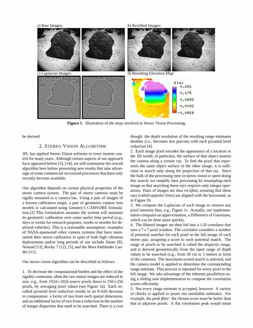
a)Raw Images: b) RectifiedImages:
c) LaplacianImages: d) ResultingElevationMap:
Figure 1. Illustrationof thestepsinvolvedin StereoVision Processing.
bederived.
2. STEREO V ISION ALGORITHM
JPLhasappliedStereoVision softwareto rover motioncon-trol for many years.Althoughcertainaspectsof ourapproachhaveappearedbefore[3], [14], wewill summarizetheoverallalgorithmherebeforepresentingnew resultsthattakeadvan-tageof somecommercialvectorizedprocessorsthathaveonlyrecentlybecomeavailable.
Our algorithmdependson certainphysicalpropertiesof thestereocamerasystem. The pair of stereocamerasmust berigidly mountedto a camerabar. Using a pair of imagesofa known calibrationtarget, a pair of geometriccameralensmodelsis calculatedusingGennery’s CAHVORE formula-tion.[2] This formulationassumesthe systemwill maintainits geometriccalibrationover someusefultime period(e.g.,daysor weeksfor researchpurposes,weeksor monthsfor de-ployedvehicles).This is a reasonableassumption:examplesof NASA-sponsoredrobot camerasystemsthat have main-tainedtheir stereocalibrationin spiteof bothhigh vibrationdeploymentsand/or long periodsof useinclude Dante[8],Nomad[13], Rocky 7 [12], [5], andtheMarsPathfinderLan-der[11].
Our stereovision algorithmcanbedescribedasfollows:
1. To decreasethecomputationalburdenandtheeffectof therigidity constraint,oftentheraw sensorimagesarereducedinsize,e.g.,from 1024� 1024sourcepixelsdown to 256� 256pixels, by averagingpixel values(seeFigure1a). Eachso-calledpyramid level reductionresultsin an 8-fold decreasein computation:a factorof two from eachspatialdimension,andanadditionalfactorof two fromareductionin thenumberof integerdisparitiesthatneedto besearched.Thereis acost
though: thedepthresolutionof theresultingrangeestimatesdoubles(i.e., becomeslessprecise)with eachpyramid levelreduction[4].2. Eachimagepixel encodestheappearanceof a locationinthe3D world; in particular, thesurfaceof thatobjectnearestthe cameraalonga certainray. To find the pixel that repre-sentsthe sameobjectsurfacein the other image,it is suffi-cient to searchonly along the projectionof that ray. Sincethebulk of theprocessingtime in stereovision is spentdoingthis search,we simplify laterprocessingby resamplingeachimagesothatsearchingtheseraysrequiresonly integeroper-ations.Pairsof imagesarethusrectified, ensuringthat theserays(calledepipolarlines) arealignedwith thehorizontal,asin Figure1b.3. We computethe Laplacianof eachimageto remove anypixel intensitybias,e.g.,Figure1c. Actually, our implemen-tationcomputesanapproximation,aDifferenceof Gaussians,which canbedonemorequickly.4. Thefilteredimagesarethenfed into a 1-D correlatorthatusesa 7 � 7 pixel window. Thecorrelatorconsidersa numberof potentialmatchesfor eachpixel in the left imageof eachstereopair, assigninga scoreto eachpotentialmatch. Therangeof pixels to be searchedis calledthe disparity range,and is derived geometricallyfrom the input rangeof depthvaluesto be searched(e.g.,from 30 cm to 3 metersin frontof thecameras).Themaximum-scoredmatchis selected,andthe cameramodelis appliedto determinethe correspondingrangeestimate.Thisprocessis repeatedfor everypixel in theleft image.We takeadvantageof theinherentparallelismus-ing a sliding sumimplementationto computethecorrelationscoresefficiently.5. Not every rangeestimateis accepted,however. A varietyof checksis appliedto pruneout unreliableestimates.Forexample,thepeakfilter: thechosenscoremustbebetterthanthat at adjacentpixels. A flat correlationpeakwould mean
(a) (b)
(c) (d)
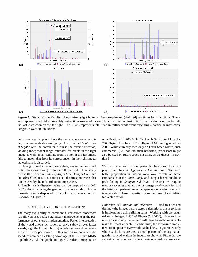
Figure 2. StereoVision Results:Unoptimized(light blue)vs. Vector-optimized(darkred) run timesfor 4 functions.TheXaxisrepresentsindividual assemblyinstructionsexecutedfor eachfunction; thefirst instructionin a functionis on thefar left,the last instructionon the far right. The Y axis representstotal time in millisecondsspentexecutinga particularinstruction,integratedover200iterations.
that many nearbypixels have the sameappearance,result-ing in an unresolvableambiguity. Also, the Left/RightLineof Sightfilter: the correlatoris run in the reversedirection,yielding independentrangeestimatesfor pixels in the rightimageaswell. If an estimatefrom a pixel in the left imagefails to matchthat from its correspondentin theright image,theestimateis discarded.6. Having prunedsomeof thesevalues,any remainingsmallisolatedregionsof rangevaluesarethrown out. Thesesafetychecks(thepeakfilter, theLeft/RightLineOf Sightfilter, andthis Blob filter) resultin a robustsetof correspondencesthatcanbeusedby theonboardautonomysystem.7. Finally, each disparity value can be mappedto a 3-D(X,Y,Z) locationusingthegeometriccameramodel.This in-formationcanbedisplayedin many forms;anelevationmapis shown in Figure1d.
3. STEREO V ISION OPTIMIZATIONS
The readyavailability of commercialvectorizedprocessorshasallowedusto realizesignificantimprovementsin theper-formanceof our stereoimplementation.Fasterinterpretationof the world allows our roversto drive safelyat ever fasterspeeds,e.g. the Urbie robot [6] which cannow drive safelyat over 1 meterpersecond.In this sectionwe documentthespeedupsobtainedby takingadvantageof thePentiumMMXcapabilities.All thegraphsin Figure2 reflecttimings taken
on a PentiumIII 700 MHz CPU with 32 Kbyte L1 cache,256Kbyte L2 cacheand512Mbyte RAM runningWindows2000.While currentlyusedonly on Earth-basedrovers,suchcommercial(i.e., non-radiationhardened)processorsmightalsobeusedon futurespacemissions,aswe discussin Sec-tion 6.
We focus attentionon four particular functions: local 2Dpixel resamplingin Differenceof Gaussianand Decimate,buffer preparationin Prepare New Row, correlationscorecomparisonin the Inner Loop, and integer-basedquadraticpeakfinding in ComputeSub-Pixel. The first two requirememoryaccessesthatjumpacrossimagerow boundaries,andthe latter two performmany independentoperationson 8-bitinteger data. Thesepropertiesmake themusefulcandidatesfor vectorization.
Differenceof Gaussianand Decimate— Usedto filter anddecimatetheimagesbeforestereocalculations,thisalgorithmis implementedusingsliding sums.Working with the origi-nal stereoimages,2 @ 240Kbytes(512*480),thisalgorithmmustaccessmainmemoryandwill incurL2 cachemisses.Tomake themostof eachL2 cachemiss,thevectorizedimple-mentationoperatesoverwholecachelines.To guaranteeonlywholecachelinesareused,a smallportionof theoriginalal-gorithmis usedto aligntheinputs.As shown in Figure2a,thevectorizedversiondoeshave a morelocalizedoccurrenceof
L2 cachemisses,andits efficientuseof PentiumIII prefetch-ing mak� esbetteruseof theL1 cache.Note,in Figure2a,theL1 cachemissescannot be directly measuredsoan estima-tion of L2 cachereadsis used.This, coupledwith a vector-izedcomputationof slidingsumvalues,resultsin a2 � speedincrease.
PrepareNext Row— Thisfunctionmaintainstheslidingsumbuffers. It accessesleft and right input imagesand bothsliding sumbuffers. Optimizing this function producesthelargestgains,4.8 � , from vectorizationandPentiumIII cacheoptimizations. This is accomplishedby operatingover fullcachelines of alignedmemory. Sinceaccessto imagedatais not aligned,this algorithm makesuseof the PentiumIIIprefetchinstruction to assistin loading the requiredcachelines into theL1 cache.Theothermemory, namelytheslid-ing sumbuffers,is guaranteedto bealigned.In Figure2b,thetall light blue barsindicatehow muchtime is wastedby theC algorithmwaiting for theprocessorto fetchoperandsfrommemory.
InnerLoop— Thecoreof thestereomatchingalgorithm,thisfunctionfinds the level of disparitywith the bestcorrelationscorefor left andright disparities,andsavesthenecessaryin-formationto generatesub-pixel information.TheC algorithmusedanunaligneddatastructureto storefour shortsandonebyte of data. This wasnot vectorizableso it was rewrittento storetwo shortsin onedatastructureandonecorrelationvaluein a table. With this simplerdatastructure,the “InnerLoop” could be codedusingvectoroperations,specifically,vectorcomparisons.Usingvectorcomparisonsratherthanifstatementspreventedpipelinethrashingandallowedfour leftandfour right disparitiesto becalculatedeverypass.Theuseof a tableof correlationscoreswasslower but necessarytoreducethesizeof thedatastructure.By reducingthesizeofthedatastructureandusingvectorcomparisons,thevectoral-gorithmperformsover1.5 timesfaster. This algorithmcouldbefurtheroptimizedby removing theright disparitycalcula-tion andusinga correlationtable,but this wouldsacrificetheleft-right-line-of-sightfilter andsub-pixel disparity.
ComputeSub-Pixel— Run only after the best correlationscoreis found for eachrow, this functiongeneratesthefinalpixel andsub-pixel disparity image. The C versionis fasterherebecauseit makesuseof thespatiallocality of the threebestcorrelationscoresfor eachdisparity, while the vector-ized versionmust do a table lookup to find the two of thethreescores.Thisoverheadis partiallyabsorbedby theuseofa vectorizeddivision ratherthanindividual integerdivisionsfor eachsub-pixel value. In Figure2d, the two annotationspoint to thetimings for thesedivisions. Note,thevectorizeddivisionis called4 timesfewerthantheintegerversion,but isstill 1.2 � faster. Unfortunately, while thisalgorithmhasmostrecentlybeenoptimizedandmaystill providea performanceincrease,at themomentit resultsin a 1.3 � slow down.
Theseperformancenumbers,measuredwith Intel’s VTune,
havebeenmeasuredwithoutthebenefitof compileroptimiza-tions.With thecompilersetto optimizefor speed,thefinal re-sultsshow theJPLstereoalgorithmrunning2.5 timesfaster.That translatesto just over 20 framesper secondon a Pen-tium III 750with 256Kbyte L2 cache,working on 256� 240imagesover32 disparitiesandwith awindow sizeof 8 � 8.
4. GESTALT NAVIGATION SYSTEM
A primary input to any navigation systemis a metrically-specifiedwaypoint.Althoughonecouldtell theroverto driverandomly, typically it will besentto a particularpoint in theworld. Waypointsmaybespecifiedstaticallyby simply giv-ing an(X,Y,Z) valuein aknown world frame,or dynamicallyby providing a modulethat cantrack a featurein the worldand always return its currentposition. In what follows weassumethe waypoint is static,but the extensionto dynamicwaypointsis trivial.
At its core,GESTALT is asetof routinesthatdecidethenextbestdirectionfor aroverto move,giventhestateof theworldalreadyseen,new sensordata,anda desiredwaypointgoal.It first checksto seeif theroverhasalreadyreachedits goal,or at leasta point within sometolerancebandaroundit. Ifso, the navigation cycle hascompletedandthe traversewillterminatesuccessfully.
The rover will rarely start out alreadyat its goal, however.Whenit hasany distanceleft to travel, it will evaluateits ter-rain informationto determinethesafetyof all possiblenearbyturns.Senseddataabouttheterraincancomefrom any num-beror typeof sensors,solongastheirresultsareprefilteredtoprovide individualpointmeasurementsof (X,Y,Z) datain therover’s (not the sensor’s) coordinateframe. GESTALT thenchoosesfrom amongthesafeturns,onethatwill besthelp itreachthe goal. The desiredturn anda shortdistance(e.g.,35 cm) is thensentto thelow-level wheelcontroller, andtherover is commandedto moveblindly.
While theroveris driving its next step,it will notuseits imag-ing sensorsto look for obstacles.Othertypesof safeguardingwill likely beenabled(e.g.,tilt sensors,motorcurrentlimits,potentiometersthat monitor kinematiclimit configurations),but noadditionalhigh-level terrain-basedplanningor sensingneedbeperformed.
At the end of eachstep, sensorsare expectedto providea reasonablyaccurateestimateof the rover’s new position.GESTALT doesnot require that the rover motion exactlymatchthat which wascommanded,but it doesassumethatwherever the rover endedup, its relative positionandorien-tationcanbereasonablyinferredandprovidedasinput. Thatis onelimitation of thesystem,thatit reliesonothermodulesto dealwith myriadpositionestimationproblems(slippinginsand,gettingstuckon arock, freeinga jammedwheel,etc).
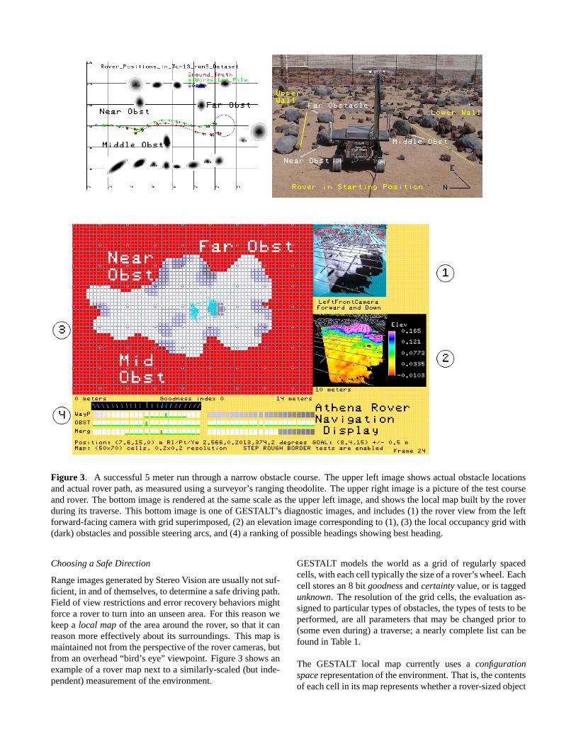
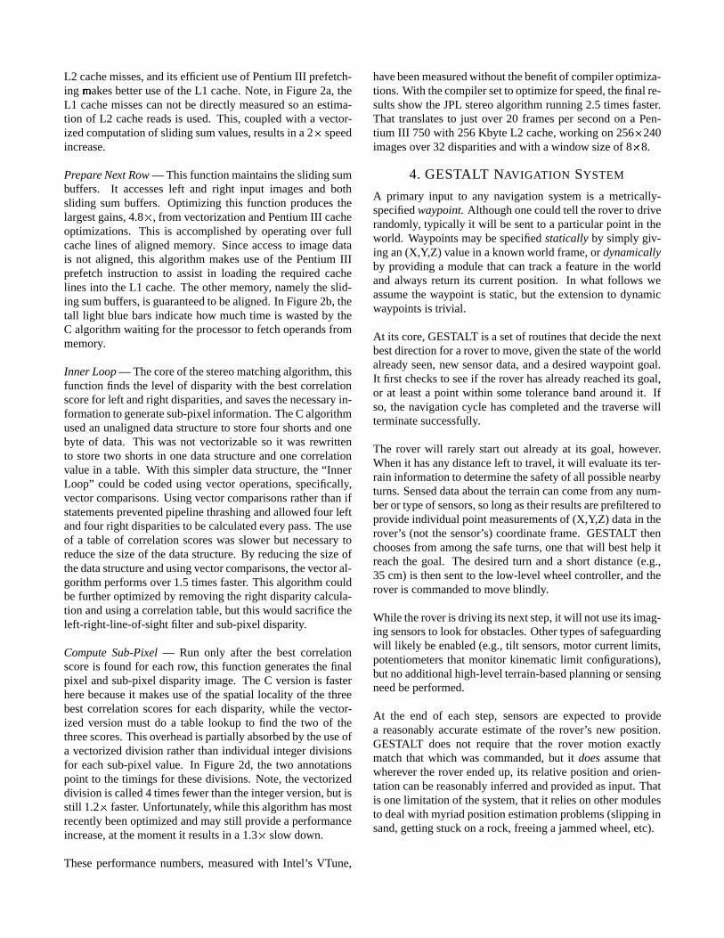
Figure 3. A successful5 meterrun througha narrow obstaclecourse.Theupperleft imageshows actualobstaclelocationsandactualroverpath,asmeasuredusinga surveyor’s rangingtheodolite.Theupperright imageis a pictureof thetestcourseandrover. Thebottomimageis renderedat thesamescaleastheupperleft image,andshows thelocal mapbuilt by theroverduring its traverse.This bottomimageis oneof GESTALT’s diagnosticimages,andincludes(1) therover view from the leftforward-facingcamerawith grid superimposed,(2) anelevationimagecorrespondingto (1), (3) thelocal occupancy grid with(dark)obstaclesandpossiblesteeringarcs,and(4) a rankingof possibleheadingsshowing bestheading.
Choosinga SafeDirection
Rangeimagesgeneratedby StereoVisionareusuallynotsuf-ficient, in andof themselves,to determineasafedriving path.Field of view restrictionsanderrorrecoverybehaviors mightforcea rover to turn into anunseenarea.For this reasonwekeepa local mapof the areaaroundthe rover, so that it canreasonmoreeffectively aboutits surroundings.This mapismaintainednot from theperspectiveof therovercameras,butfrom anoverhead“bird’ s eye” viewpoint. Figure3 shows anexampleof a rover mapnext to a similarly-scaled(but inde-pendent)measurementof theenvironment.
GESTALT modelsthe world as a grid of regularly spacedcells,with eachcell typically thesizeof arover’swheel.Eachcell storesan8 bit goodnessandcertaintyvalue,or is taggedunknown. Theresolutionof thegrid cells, theevaluationas-signedto particulartypesof obstacles,thetypesof teststo beperformed,areall parametersthat may be changedprior to(someevenduring) a traverse;a nearlycompletelist canbefoundin Table1.
The GESTALT local map currently uses a configurationspacerepresentationof theenvironment.Thatis, thecontentsof eachcell in its maprepresentswhetherarover-sizedobject
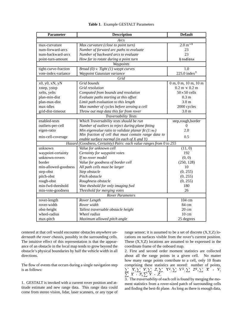
Table 1. ExampleGESTALT Parameters
Parameter Description DefaultArcs
max-curvature Maxcurvature(closeto point turn) 2.0m ���num-forward-arcs Numberof forward arc pathsto evaluate 23num-backward-arcs Numberof backward arcsto evaluate 23point-turn-amount Howfar to rotateduringa point turn � ���� ��������
Waypointstight-curve-fraction Broad(0) v. Tight (1) wayptcurves 1.0vote-index-variance WaypointGaussianvariance 225.0index
Grid
x0, y0, xN, yN Grid bounds 0 m, 0 m, 10 m, 10 mxstep,ystep Grid resolution 0.2m � 0.2mxelts,yelts Computedfromboundsandresolution 50 � 50cellsplan-min-dist Evaluatepathsstartingat thisoffset 0.3mplan-max-dist Limit pathevaluationto this length 3.0mmax-idles Maxnumberof cyclesbeforezeroing a cell 2000cyclesgrid-dist-timeout Throw outmapdatathis far fromrover 3.0m
Traversability Testsenabled-tests Which Traversability testsshouldberun step,rough,borderoutliers-per-cell Numberof outliers to rejectduringplanefitting 0eigen-ratio Min eigenvalueratio to validateplanarfit (1: � ) 2.0
min-cell-coverageMin fraction of cell that mustcontain range data toenablesurfacenormal(in each of X andY)
0.5
Hazard (Goodness,Certainty)Pairs: each valuerangesfrom0 to 255unknown Valuefor unknowncell (11,0)waypoint-certainty Certaintyfor waypointvotes 192unknown-rovers If no rover model (0, 0)border Valuefor goodnessof bordercell (250,128)min-allowed-goodness All pathcellsmustbelarger 10step-obst Stepobstacle (0, 255)pitch-obst Pitch obstacle (0, 255)rough-obst Roughnessobstacle (0, 255)min-fwd-threshold Votethesholdfor only imaging fwd 180min-vote-goodness Thresholdfor mergingvotes 26
RoverParametersrover-length RoverLength 104cmrover-width Roverwidth 84 cmobst-height Tallesttraversableobstacleheight 20 cmwheel-radius Wheelradius 10 cmmax-pitch Maximumallowedpitch angle 25degrees
centeredat thatcell would encounterobstaclesanywhereun-derneaththerover chassis,possiblyin thesurroundingcells.The intuitive effect of this representationis that the appear-anceof anobstaclein thelocalmaptendsto grow beyondtheobstacle’sphysicalboundariesby half thevehiclewidth in alldirections.
Theflow of eventsthatoccursduringasinglenavigationstepis asfollows:
1. GESTALT is invokedwith a currentroverpositionandat-titude estimateand new rangedata. This rangedatacouldcomefrom stereovision, lidar, laserscanners,or any typeof
rangesensor;it is assumedto bea setof discrete(X,Y,Z) lo-cationson surfacesvisible from the rover’s currentposition.These(X,Y,Z) locationsareassumedto be expressedin thecoordinateframeof theonboardmap.2. First and secondorder moment statisticsare collectedabout all the range points in a given cell. No matterhow many rangepoints contribute to a cell, only 10 floatscomprising thesestatisticsare stored: number of points,� ����� ����� � ��� � ��� � ��� � ��� � !"�#��$�%!&�&���%�'!&�
.3. Thetraversabilityof eachcell is foundbymergingthemo-mentstatisticsfrom a rover-sizedpatchof surroundingcellsandfindingthebest-fitplane.As longasthereis enoughdata,
andthedatapassessomepreliminarytests(e.g.,at leasthalfthe cells( have more than1 point), the planeparametersareusedto computeseveralhazardmeasures:StepHazard: Find the maximumelevation differencebe-
tweenany pair of cells in this patch ) . If lessthan1/3 therover clearanceheight( * ), thereis no stephazard;elsethereis a hazardwith goodness+-,/. !10 + 2436587 0 + � )�9�*;:<: .RoughnessHazard: Computethe residualfrom the planar
fit = . If lessthan roughnessfraction! �> * , thereis no rough-
nesshazard;elsethereis a hazardwith goodness,�?1? !@0 +A236587 0 + � roughnessfraction!CBD :E: .
Pitch Hazard: ComputetheslopeF from theplanarfit (onlyif enoughdataarepresent).Thereisapitchhazardwith good-ness,�?1? !10 +&243G5H7 0 + � I
maxpitch angle:E: .BorderHazard: If this cell bordersanunknown cell, there
is a hazardwith goodnessbordergoodness.The minimum goodnessaccordingto thesehazardsis as-signedto thecell with a certaintyof 255.4. Hazard Arc votes: Arc pathsareconsideredout to min(dist to goal,defaultlength). A weightedsum,biasedto con-sidernearbycellsmorestrongly, is usedto find the valueofeacharcpath.Thevaluesassignedto eacharcpath,forwardandbackward, aredisplayedin the diagnosticimageas themiddlerow next to Figure3, part(4).5. Waypoint Arc votes: Independentlyof thehazardavoid-ancesystem,thesamesetof arcsis assignedgoodnessvaluesaccordingto how well they move the rover toward its goalpoint. Thearcthatbestpointstherover towardthegoalgetsthehighestvalue,andthatvalueformsthepeakof agaussiancurve that is appliedto the otherarcs. The varianceof thiscurve is a systemparameter, vote-index-variance. Both for-wardandbackwardvotesareassignedvalues;arcsrunninginthe directiontoward the goalget a peakof 255, thosein theoppositedirectiongetapeakof 128.Waypointarcpathvotesaredisplayedin thetop row of Figure3, part(4).6. Merging Hazard and Waypoint arc votes: Hazardandwaypointvotesaremergedpairwise.If eithervoteis below athresholdthentheminimumis chosen.Otherwiseaweightedgoodnesssumis computed,usingthe certaintiesasweights.Themergedvotes,from whichtheactualcommandedarcwillbechosen,aredisplayedin thebottomrow of Figure3, part(4).7. Finally, thearcwith maximumgoodnessis selectedasthenext rover step. In caseof multiple peaks,themiddlearcofthe longestadjacentsetof votesis chosen.Multiple candi-datesareindicatedin Figure3, part (4) with a greenunder-line highlight,andtheactualarcchosenis taggedwith agreenbox.
As mentionedpreviously, theprocessof arcselectionrepeatsuntil the desiredwaypoint is reachedor someother condi-tion terminatesthe run. Of coursethings tendto work bet-ter if theroveractuallyfollows thetrajectorycommandedbyGESTALT, but sincethepathis reevaluatedateverystepthisis not a strict requirement.
5. BASELINE SYSTEM TIMINGS
In Section3 we describedcertainoptimizationsto theStereoVision codethat take advantageof thevectorizedMMX op-erationsavailableon the Pentiumarchitecture.To provide abenchmarkfor future studies,in this sectionwe presentthe(unoptimized)timings of the StereoVision and GESTALTNavigationsoftwareonfour differentCPUs.TheR3000CPUis partof acompleterovervehicle,theAthenaSDM; theoth-ersaresimplydesktopmachinesonwhichthesamecodewasbuilt, andtestedonrealimagesloggedfrom anearlierrunonthe AthenaSDM. The desktopresultsdemonstratethe kindof speedupattainableusingcommercialCPUs,andeachoftheseCPUshasbeenusedto control rovers in the past(orwill beusedin thenearfuture).
R3000(AthenaSDM)— [1] A prototypeof aMarsRoverde-sign that predatesMER, the AthenaSoftwareDevelopmentModel(SDM) roverhasanR300012MHz CPUwith 2 Kbytedatacache,4 Kbyte instructioncache,and32MbytesDRAMmemory. Its topspeedmechanicallyis about5 cm/s,but com-putationalconstraintslimit it to 1 cm/sonaveragewhile driv-ing with obstacleavoidanceenabled.
RAD6000— Somesimulationtiming numbersweregener-atedon a desktopcagenot connectedto a physicalvehicle.Thisunit hasaRAD6000RISCprocessor, similar to thetypeof processorplannedfor the 2003 Mars ExplorationRovermission,runningat 20MHz with 8 KbytesL1 cacheand128Mbytes RAM. Individual timings generatedon this systemarealwaysin multiplesof “ticks”, oneof which takesatmost�J<K seconds.
SunUltra 10 Workstation— Additional simulationtimingscomefrom adesktopworkstationnotconnectedto aphysicalvehicle.ThisworkstationhasaSunSparc-IIiCPUrunningat300MHz with a2 Mbyteexternal(L2) cacheand128MbytesRAM.
Linux Workstation — Additional simulation timings comefrom a desktopworkstationnot connectedto a physicalve-hicle. ThisworkstationhasaPentiumIII CPUrunningat500MHz with 32KbytesL1 cache,512KbytesL2 cacheand256MbytesRAM.
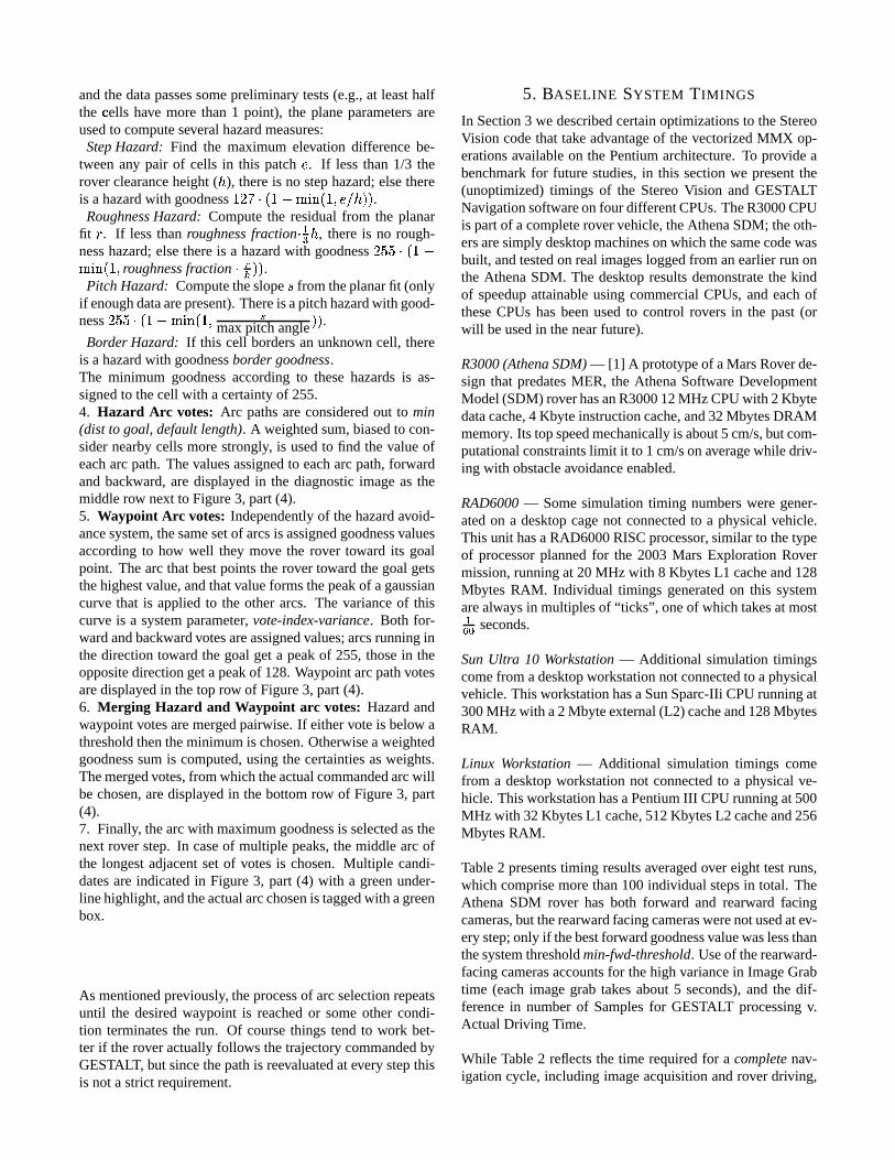
Table2 presentstiming resultsaveragedover eight testruns,which comprisemorethan100individual stepsin total. TheAthena SDM rover has both forward and rearward facingcameras,but therearwardfacingcameraswerenotusedatev-erystep;only if thebestforwardgoodnessvaluewaslessthanthesystemthresholdmin-fwd-threshold. Useof therearward-facingcamerasaccountsfor thehigh variancein ImageGrabtime (eachimagegrab takesabout5 seconds),and the dif-ferencein numberof Samplesfor GESTALT processingv.ActualDriving Time.
While Table2 reflectsthe time requiredfor a completenav-igationcycle, including imageacquisitionandrover driving,
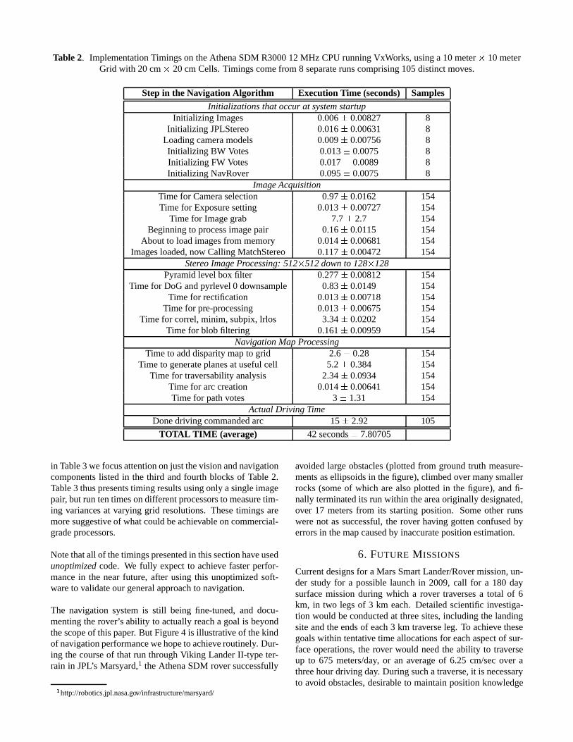
Table 2. ImplementationTimingson theAthenaSDM R300012MHz CPUrunningVxWorks,usinga 10 meter � 10 meterGrid with 20 cm � 20cm Cells.Timingscomefrom 8 separaterunscomprising105distinctmoves.
Step in the Navigation Algorithm Execution Time (seconds) SamplesInitializationsthatoccurat systemstartup
Initializing Images 0.006 L 0.00827 8Initializing JPLStereo 0.016 L 0.00631 8
Loadingcameramodels 0.009 L 0.00756 8Initializing BW Votes 0.013 L 0.0075 8Initializing FW Votes 0.017 L 0.0089 8Initializing NavRover 0.095 L 0.0075 8
ImageAcquisitionTime for Cameraselection 0.97 L 0.0162 154Time for Exposuresetting 0.013 L 0.00727 154
Time for Imagegrab 7.7 L 2.7 154Beginningto processimagepair 0.16 L 0.0115 154
About to loadimagesfrom memory 0.014 L 0.00681 154Imagesloaded,now CallingMatchStereo 0.117 L 0.00472 154
StereoImageProcessing:512� 512downto 128� 128Pyramidlevel boxfilter 0.277 L 0.00812 154
Time for DoGandpyrlevel 0 downsample 0.83 L 0.0149 154Time for rectification 0.013 L 0.00718 154
Time for pre-processing 0.013 L 0.00675 154Time for correl,minim, subpix,lrlos 3.34 L 0.0202 154
Time for blobfiltering 0.161 L 0.00959 154NavigationMapProcessing
Time to adddisparitymapto grid 2.6 L 0.28 154Time to generateplanesatusefulcell 5.2 L 0.384 154
Time for traversabilityanalysis 2.34 L 0.0934 154Time for arccreation 0.014 L 0.00641 154Time for pathvotes 3 L 1.31 154
ActualDriving TimeDonedriving commandedarc 15 L 2.92 105
TOTAL TIME (average) 42 secondsL 7.80705
in Table3 wefocusattentiononjustthevisionandnavigationcomponentslisted in the third andfourth blocksof Table2.Table3 thuspresentstiming resultsusingonly asingleimagepair, but run tentimesondifferentprocessorsto measuretim-ing variancesat varying grid resolutions.Thesetimings aremoresuggestiveof whatcouldbeachievableoncommercial-gradeprocessors.
Notethatall of thetimingspresentedin thissectionhaveusedunoptimizedcode. We fully expect to achieve fasterperfor-mancein the nearfuture, after using this unoptimizedsoft-wareto validateour generalapproachto navigation.
The navigation systemis still being fine-tuned,and docu-mentingtherover’sability to actuallyreacha goal is beyondthescopeof thispaper. But Figure4 is illustrativeof thekindof navigationperformancewehopeto achieveroutinely. Dur-ing thecourseof that run throughViking LanderII-type ter-rain in JPL’s Marsyard,1 theAthenaSDM roversuccessfully
Mhttp://robotics.jpl.nasa.gov/infrastructure/marsyard/
avoidedlarge obstacles(plottedfrom groundtruth measure-mentsasellipsoidsin thefigure),climbedovermany smallerrocks(someof which arealsoplottedin the figure), andfi-nally terminatedits runwithin theareaoriginally designated,over 17 metersfrom its startingposition. Someother runswerenot assuccessful,the rover having gottenconfusedbyerrorsin themapcausedby inaccuratepositionestimation.
6. FUTURE M ISSIONS
Currentdesignsfor a MarsSmartLander/Rovermission,un-der study for a possiblelaunchin 2009,call for a 180 daysurfacemissionduring which a rover traversesa total of 6km, in two legs of 3 km each. Detailedscientific investiga-tion would beconductedat threesites,includingthe landingsiteandtheendsof each3 km traverseleg. To achieve thesegoalswithin tentative time allocationsfor eachaspectof sur-faceoperations,the rover would needthe ability to traverseup to 675 meters/day, or an averageof 6.25 cm/secover athreehourdriving day. Duringsuchatraverse,it is necessaryto avoid obstacles,desirableto maintainpositionknowledge
Table 3. SimulationTimings,RunningGESTALT 10 timeson a SingleRealImagePair usinga9 meterx 9 meterGrid atDifferingResolutions
Pentium III 500 MHz Linux SystemGrid Cell Resolution: 50 � 50 cm
20 � 20 cm
10 � 10 cm
Time (seconds) Time (seconds) Time (seconds)
Roverandgrid initialization 0.00218L 5.05e-05 0.00611L 0.000208 0.021 L 0.000276DoG andpyrlevel 2 downsample 0.285 L 0.009 0.283 L 0.0126 0.27 L 0.00196Rectification 0.000104L 5.87e-06 0.000105L 8.7e-06 0.000104L 4.8e-06Pre-processing 3.98e-05L 7.48e-07 4.14e-05L 1.69e-06 4.02e-05L 4e-07Correl,minim, subpix,lrlos 0.0729L 0.00544 0.0813L 0.0303 0.0742L 0.00886Blob filtering 0.00311L 0.00013 0.0031L 9.86e-05 0.00307L 4.73e-05Fit planes 0.0294L 0.00652 0.14 L 0.0101 1 L 0.00564Traversabilityanalysis 0.00171L 4.01e-05 0.0192 L 0.000544 0.144 L 0.0114Pathvotes 0.022 L 0.00118 0.0454 L 0.000814 0.0838L 0.00147Generatingfloat rangeXYZ map 0.00436L 0.000154 0.00659L 0.00665 0.00649L 0.00666TOTAL TIME (average) 0.421 L 0.0124 0.584 L 0.035 1.61 L 0.0171
Sparc 300 MHz Solaris SystemRoverandgrid initialization 0.022 L 0.00819 0.0258L 0.00864 0.0789L 0.0163DoG andpyrlevel 2 downsample 1.06 L 0.112 1.11 L 0.185 1.06 L 0.152Rectification 0.000241L 3.16e-05 0.00301L 0.00831 0.00025L 7.07e-06Pre-processing 0.000104L 2.25e-06 0.000113L 2.8e-05 0.000108L 2.1e-06Correl,minim, subpix,lrlos 0.218 L 0.0452 0.246 L 0.049 0.271 L 0.0815Blob filtering 0.0177L 0.0134 0.0165 L 0.01 0.0154L 0.0105Fit planes 0.0761L 0.0161 0.404 L 0.0745 2.72 L 0.35Traversabilityanalysis 0.00351L 0.000341 0.0579L 0.0155 0.45 L 0.106Pathvotes 0.0637L 0.0155 0.126 L 0.0236 0.214 L 0.0511Generatingfloat rangeXYZ map 0.0156L 0.0116 0.0131L 0.00891 0.0154L 0.0123TOTAL TIME (average) 1.48 L 0.124 2.0 L 0.208 4.82 L 0.408
RAD6000 20 MHz VxWorks System ( �JEK second resolution)Roverandgrid initialization 2.42 L 0.147 2.37 L 0.0489 2.02 L 0.145DoG andpyrlevel 2 downsample 4.65 L 0.01 4.63 L 0.0111 4.76 L 0.194Rectification 0 L 0 0 L 0 0 L 0Pre-processing 0 L 0 0.00167L 0.005 0 L 0Correl,minim, subpix,lrlos 1.69 L 0.00834 1.69 L 0.00764 1.71 L 0.00764Blob filtering 0.0967L 0.00667 0.095 L 0.00764 0.0967L 0.00667Fit planes 1.4 L 0.0289 4.21 L 0.015 25.1 L 0.0125Traversabilityanalysis 0.0567L 0.00816 0.685 L 0.005 5.49 L 0.013Pathvotes 1.15 L 0 1.69 L 0.00764 3.06 L 0.00764Generatingfloat rangeXYZ map N/A N/A N/ATOTAL TIME (average) 11.5 L 0.151 15.4 L 0.0544 42.2 L 0.0328
to 3%of distancetraveled,anddesirableto conduct“traversescience”observationswith onboardinstruments.
Thestereovision andGESTALT systemsdescribedearlierinthis paperprovide a baselineobstacleavoidancesystemforpossibleusein the SmartLander/Rover mission. The com-plexity of thesealgorithmsmay increasebefore2009to im-provenavigationperformancein roughterrain.A possibleso-lution to thepositionestimationgoal is a “visual odometry”algorithm[7], which selectsandtrackslocal terrainfeaturesin stereoimageryto estimatethe motionof the rover duringthe traverse. Traversescienceapplicationsarenot yet well
specified;possibilitiesincludeanalyzingpoint spectrometerdataor multispectralimageryfor mineralclassification.
Since the Smart Lander/Rover is to include active landinghazardavoidance,the missiondesignis baselininga radia-tion hardenedprimaryprocessorfor reliableperformanceofentry, descent,andlandingoperations.Thecurrentstrawmanchoicefor thisprocessoris a133MHz radhardPowerPC750.Optionsexist to carrymorethanoneof these,if necessary, tohandlethe requiredprocessingload. We arealsoexaminingthe possibility of flying a commercialgrademicroprocessorasa co-processor, to provideadditionalhorsepower for rover
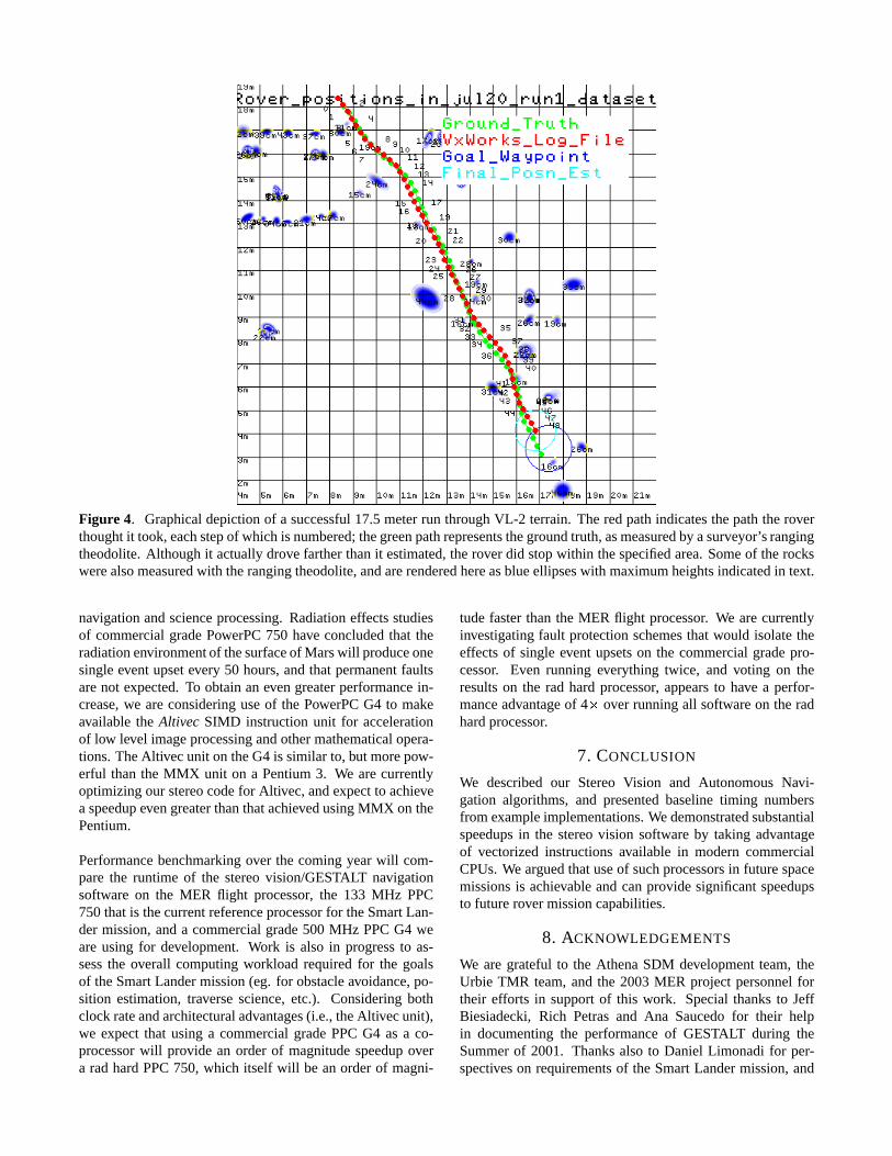
Figure 4. Graphicaldepictionof a successful17.5meterrun throughVL-2 terrain. Theredpathindicatesthepaththeroverthoughtit took,eachstepof whichis numbered;thegreenpathrepresentsthegroundtruth,asmeasuredby asurveyor’srangingtheodolite.Althoughit actuallydrove fartherthanit estimated,theroverdid stopwithin thespecifiedarea.Someof therockswerealsomeasuredwith therangingtheodolite,andarerenderedhereasblueellipseswith maximumheightsindicatedin text.
navigationandscienceprocessing.Radiationeffectsstudiesof commercialgradePowerPC750 have concludedthat theradiationenvironmentof thesurfaceof Marswill produceonesingleeventupsetevery 50 hours,andthatpermanentfaultsarenot expected.To obtainanevengreaterperformancein-crease,we areconsideringuseof the PowerPCG4 to makeavailable the Altivec SIMD instructionunit for accelerationof low level imageprocessingandothermathematicalopera-tions.TheAlti vecunit on theG4is similar to, but morepow-erful thanthe MMX unit on a Pentium3. We arecurrentlyoptimizingour stereocodefor Alti vec,andexpectto achieveaspeedupevengreaterthanthatachievedusingMMX on thePentium.
Performancebenchmarkingover the comingyearwill com-parethe runtime of the stereovision/GESTALT navigationsoftware on the MER flight processor, the 133 MHz PPC750thatis thecurrentreferenceprocessorfor theSmartLan-der mission,anda commercialgrade500 MHz PPCG4 weareusing for development. Work is also in progressto as-sessthe overall computingworkload requiredfor the goalsof theSmartLandermission(eg. for obstacleavoidance,po-sition estimation,traversescience,etc.). Consideringbothclockrateandarchitecturaladvantages(i.e., theAlti vecunit),we expect that usinga commercialgradePPCG4 as a co-processorwill provide an orderof magnitudespeedupovera rad hardPPC750,which itself will be anorderof magni-
tudefasterthanthe MER flight processor. We arecurrentlyinvestigatingfault protectionschemesthat would isolatetheeffectsof singleevent upsetson the commercialgradepro-cessor. Even running everything twice, and voting on theresultson the rad hardprocessor, appearsto have a perfor-manceadvantageof 4 � over runningall softwareon theradhardprocessor.
7. CONCLUSION
We describedour Stereo Vision and AutonomousNavi-gation algorithms,and presentedbaselinetiming numbersfrom exampleimplementations.Wedemonstratedsubstantialspeedupsin the stereovision softwareby taking advantageof vectorizedinstructionsavailable in moderncommercialCPUs.We arguedthatuseof suchprocessorsin futurespacemissionsis achievableandcanprovide significantspeedupsto futurerovermissioncapabilities.
8. ACKNOWLEDGEMENTS
We aregrateful to the AthenaSDM developmentteam,theUrbie TMR team,andthe 2003MER projectpersonnelfortheir efforts in supportof this work. Specialthanksto JeffBiesiadecki,Rich Petrasand Ana Saucedofor their helpin documentingthe performanceof GESTALT during theSummerof 2001. Thanksalso to Daniel Limonadi for per-spectiveson requirementsof the SmartLandermission,and
RaphaelSomeandRobertFerrarofor informationaboutra-diationN effects on processorson the surfaceof Mars. Andthanksto Reg Willson for usefulfeedbackonearlierversionsof thepaper.
The work describedin this paperwascarriedout at the JetPropulsionLaboratory, California Institute of Technology,undera contractto the NationalAeronauticsandSpaceAd-ministration.
REFERENCES
[1] Jeffrey Biesiadecki,Mark Maimone, and Jack Mor-rison. The Athena SDM rover: A testbed formars rover mobility. In International Symposiumon Artificial Intelligence, Robotics, and Automa-tion for Space(i-SAIRAS), Montreal, Canada,June2001. http://robotics.jpl.nasa.gov/people/mwm/sdm-mobility/.
[2] Donald B. Gennery. Calibration and Orientation ofCameras in ComputerVision, chapterLeast-SquaresCameraCalibrationIncludingLensDistortionandAu-tomaticEditing of CalibrationPoints,pages123–136.SpringerVerlag(A. GruenandT. Huang,ed.),2001.
[3] P. GrandjeanL. Matthies.Stochasticperformancemod-elingandevaluationof obstacledetectabilitywith imag-ing rangesensors.IEEE Transactionson RoboticsandAutomation, 10(6):783–792,December1994.
[4] M. Maimone,L. Matthies,J.Osborn,E.Rollins,J.Teza,andS. Thayer. A photo-realistic3-D mappingsystemfor extreme nuclear environments: Chornobyl. InInternationalRoboticsandSystemsConference(IROS),pages1521–1527,VictoraB.C.,Canada,October1998.http://robotics.jpl.nasa.gov/people/mwm/pioneer/iros98/.
[5] Mark Maimone, Issa Nesnas,and Hari Das. Au-tonomousrock tracking and acquisitionfrom a marsrover. In InternationalSymposiumon Artificial Intelli-gence, Robotics,andAutomationfor Space(i-SAIRAS),pages329–334,Noordwijk, Netherlands,June1999.http://robotics.jpl.nasa.gov/tasks/pdm/papers/isairas99/.
[6] L. Matthies,Y. Xiong, R. Hogg, D. Zhu, A. Rankin,B. Kennedy, M. Hebert, R. Maclachlan, C. Won,T. Frost, G. Sukhatme,M. McHenry, and S. Gold-berg. A portable, autonomousurban reconnais-sance robot. In Intelligent AutonomousSystems,Venice, Italy, July 2000. http://robotics.jpl.nasa.gov/tasks/tmr/papers/UrbanRobotPaper0700.pdf.
[7] Clark F. Olson, Larry H. Matthies, Marcel Schop-pers, and Mark W. Maimone. Stereo ego-motionimprovements for robust rover navigation. InInternational Conference on Robotics and Au-tomation, pages 1099–1104, Seoul, Korea, 2001.http://robotics.jpl.nasa.gov/people/mwm/papers/icra01.pdf.
[8] Bill Ross. A practicalstereovision system. In IEEEConferenceon ComputerVision and Pattern Recogni-
tion, pages148–153,New York, 1993.
[9] ReidSimmons,LarsHenriksen,LonnieChrisman,andGreg Whelan.Obstacleavoidanceandsafeguardingfora lunar rover. In AIAA Forum on AdvancedDevelop-mentsin Spacerobotics, Madison,WI, August 1996.http://www.cs.cmu.edu/˜reids/papers/AIAAobsAvoid.pdf.
[10] Sanjiv Singh, Kurt Schwehr, Reid Simmons, TreySmith, Anthony Stentz, Vandi Verma, and AlexYahja. Recent progress in local and globaltraversability for planetary rovers. In Interna-tional Conference on Robotics and Automation,2000. http://www.frc.ri.cmu.edu/projects/mars/publi-cations/globallocal icra2000.ps.gz.
[11] P. H. Smith, J. F. Bell III, N. T. Bridges, D. T.Britt, L. Gaddis, R. Greeley, H. U. Keller, K. E.Herkenhoff, R. Jaumann, J. R. Johnson, R. L.Kirk, M. Lemmon, J. N. Maki, M. C. Malin,S. L. Murchie, J. Oberst, R. J. Reid T. J. Parker,R. Sablotny, L. A. Soderblom, C. Stoker, R. Sul-livan, N. Thomas, M. G. Tomasko, W. Ward,and E. Wegryn. Results from the mars pathfindercamera. Science, 278(5344):1758,December1997.http://www.sciencemag.org/cgi/content/full/278/5344/1758.
[12] Richard Volpe. Navigation results from desertfieldtests of the Rocky 7 mars rover prototype. In-ternational Journal of Robotics Research, 18(7),SpecialIssueon Field andServiceRobots,July 1999.http://robotics.jpl.nasa.gov/people/volpe/papers/JnavMay.pdf.
[13] David Wettergreen, DeepakBapna, Mark Maimone,and Geb Thomas. Developing nomad for roboticexploration of the atacamadesert. Roboticsand Au-tonomousSystems, 26(2–3):127–148, February1999.http://robotics.jpl.nasa.gov/people/mwm/papers/98ras.nomad.pdf.
[14] Yalin Xiong and Larry Matthies. Error analysisof a real-time stereo system. In Computer Visionand Pattern Recognition, pages 1087–1093, 1997.http://www.cs.cmu.edu/˜yx/papers/StereoError97.pdf.
9. BIOGRAPHIES
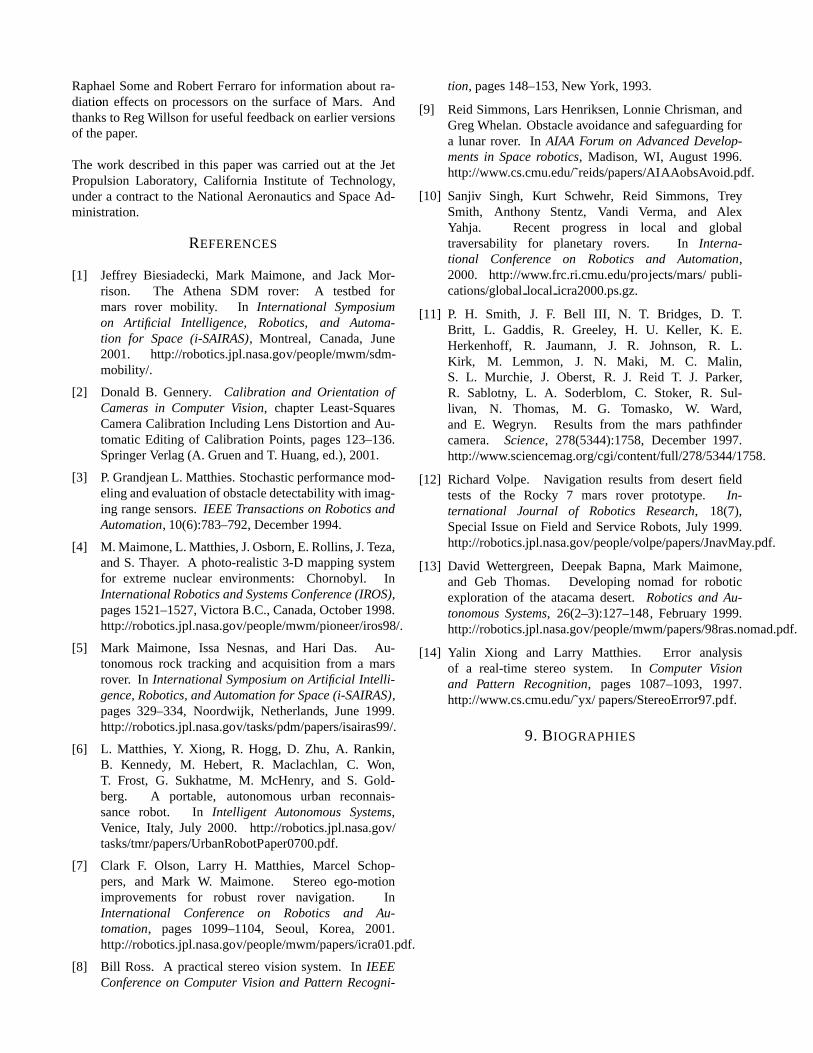
Steve Goldberg is a researcher at In-delibleSystemsin LosAngeles,Califor-nia. He earneda Bachelors of Com-puter Engineeringfrom the Universityof SouthernCalifornia in 1999 wherehewasanundergraduateresearch assis-tant. He currently is working as a con-tractorat theJetPropulsionLaboratory.
Dr. Mark Maimone is a MachineVisionresearcher at the Jet PropulsionLabo-ratory. In 1989 he completedthe In-ternational SpaceUniversity’s summerprogram, in which he participated inthe designof a lunar polar orbiter. Heearnedhis Ph.D. in ComputerSciencefrom the ComputerScienceDepartment
of CarnegieMellon University in 1996,andwasthena Post-doctoral Research Associateat Carnegie Mellon’s RoboticsInstitute, servingas Navigationand Software Lead for the1997AtacamaDesertTrek.Sincestartingat JPL in 1997,hehasworkedon theseveral MarsRover research projects,anda visionsystemfor inspectionof theChornobylreactor. Markis currently a memberof the 2003Mars Exploration Roverflight software team,andis developingthevisionandnaviga-tion subsystemsfor therobotsthatNASAwill sendto Mars in2003.His research interestsincluderoboticnavigationalau-tonomy, stereovision,camera calibration,andsoftwareenvi-ronments.
Dr. Larry Matthies obtained aPh.D.degreein ComputerSciencefromCarnegie Mellon University in 1989,thenmovedto the Jet PropulsionLabo-ratory, where he is currentlySupervisorof theMachineVisionGroup.Hehasex-tensiveexperiencein 3-D sensing, worldmodeling, andpathplanningfor robotic
navigation. At JPL, he pioneered the developmentof real-timealgorithmsfor stereovision-basedobstacledetectionforautonomousnavigationof robotic vehiclesand wasa mem-ber of theteamthat developedtheSojournerMars rover. Hecurrently leadsprojectson computervision for roboticvehi-clessponsoredby NASA,DARPA, and the U.S.Army. He isa memberof the editorial board of the AutonomousRobotsjournal andan adjunctprofessorof ComputerScienceat theUniversityof SouthernCalifornia.