Embed Size (px)
Citation preview
135
A. Petrosyan, M. Arimura, B. Gasparyan, S. Nahapetyan & C. Chataigner
Early Holocene Sites of the Republic
of Armenia: Questions of Cultural
Distribution and Chronology
Arthur Petrosyan, Makoto Arimura, Boris Gasparyan, Samvel Nahapetyan and
Christine Chataigner
1. IntroductionUntil recently, the earliest farming communities in Armenia were dated from the early 6th
millennium BC. However, these sites are attributed to the Late Neolithic and display well
established food-producing economies (Badalyan el al. 2007; Arimura et al. 2010). Thus, one of the
main archaeological problems for the territory of Armenia and the whole southern Caucasian region
is the reconstruction of the process of Neolithization. Unfortunately however, the archaeological
sites dating to the terminal Pleistocene/Early Holocene required to establish such a reconstruction
were very poorly represented. Happily, investigations within the last decade have revealed the very
fi rst terminal Pleistocene and Early Holocene sites in the country. These new fi ndings, which build
upon developments of the late 19th century, are opening new perspectives on the Neolithic Period.
In general, the history of research into the Neolithic of Armenia can be divided into three stages:
The First stage (from the beginning of the 20th century–1960) is characterized by a
period of surface collection, artifact definition, and chronological placement based on European
Global Stone Age periodization schemes (J. de Morgan, A. Potapov, Y. Bayburtyan, S. Zamyatnin, M.
Panichkina, S. Sardaryan).
The Second stage (1960–2000) is based on the discovery and research of certain Neolithic
period archaeological sites such as the Aknashen-Khatunarkh (R.Torosyan) and Masis Blur (G.E.
Areshian) settlements in the Ararat valley and the Hatis-10 open-air site, which is a large workshop
near the outcrops of obsidian in the Kotayk Plateau (H. Ghazaryan). This research stage involved
the study of stratified Neolithic materials and the definition of their local characteristics and
Early Holocene sites of the Republic of Armenia: Questions of cultural distribution and chronology
136
chronological position in comparison with the synchronous sites of the southern Caucasus and Near
East.
The Third stage (2000–2014) is significant for the targeted systematic research of
Neolithic sites through an established network of local and foreign specialists and, importantly,
with usage of modern excavation and analytical techniques. It is during this stage that several Early
Holocene sites were discovered across Armenia (B. Gasparyan). New and signifi cant results were
achieved in parallel while re-excavating three Late Neolithic settlements in the Ararat Valley –
Aratashen, Aknashen-Khatunarkh (R. Badalyan), and Masis Blur (P. Avetisyan and G.E. Areshian).
Early Holocene sites were first detected in the Aparan Depression as a result of
investigations by the Armenian-French joint expedition (directors: B. Gasparyan, Institute of
Archaeology and Ethnography of the National Academy of Sciences of the Republic of Armenia
and C. Chataigner, Maison de l’Orient et de la Méditerranée, Lyon), which, because of the general
lack of such materials from previous work, provided a wealth of information about this period.
While recent years have seen discovery of other Early Holocene sites in other regions of Armenia
(Ararat, Shirak and Lori Depressions, Aghstev River Valley, etc.), it is those located in the limits of
the Aparan Depression that display what appears to be a consistent cultural phenomenon within one
geomorphologic unit. It is therefore these sites that form the framework of our discussion.
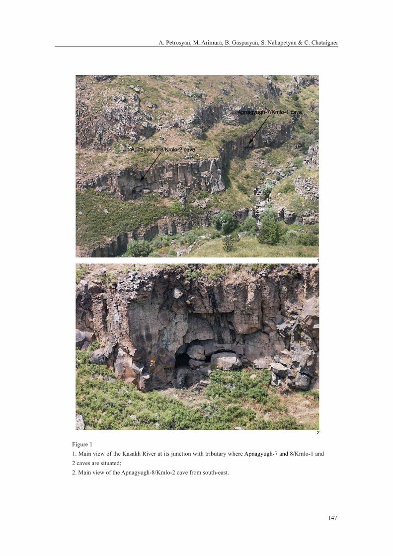
2. Apnagyugh-8/Kmlo-2 caveApnagyugh-8/Kmlo-2 is situated on the eastern side of the Aragats massif, in the middle stream
of the Kasakh River valley at its junction with a small tributary. The absolute elevation of the
cave, opened in a basaltic lava flow, is about 1700 m asl. Internal erosion caused most of the
cave’s degradation, although earthquakes were probably responsible for the ultimate collapse of
the entrance (Figure 1). The site was discovered in 2002 by an Armenian-French joint expedition
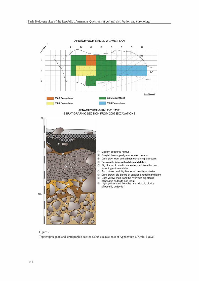
during a systematic survey in the Kasakh River valley. A test trench revealed the presence in the
cave of obsidian artifacts and faunal remains. The excavations started in 2003 and, over the next
four fi eld seasons, about 10 m2 were excavated (Figure 2).
Wind-blown sediments were initially deposited on a mass of fallen rocks from the
collapsed vault. The upper layer 1 lies sub-horizontally and corresponds to a Medieval occupation,
which, unfortunately, has heavily disturbed the upper part of the archaeologically rich underlying
prehistoric layers 2-5 (Figure 2). In these layers there are lumps of hardened fl oor full of obsidian
artifacts and faunal remains, which is probably the only evidence of in situ prehistoric occupation in
the cave.
137
A. Petrosyan, M. Arimura, B. Gasparyan, S. Nahapetyan & C. Chataigner
With the exception of domestic sheep, the fl oral and faunal remains belong exclusively to
wild species. It is important to note, however, that the stratigraphic position of the few sheep bones
is tenuous since the earthquake-induced porch collapse may have caused some material to percolate
down between the blocks of stone and ultimately come to rest more than 1 m deeper. The objects of
the prehistoric layers are thus possibly mixed together and displaced.
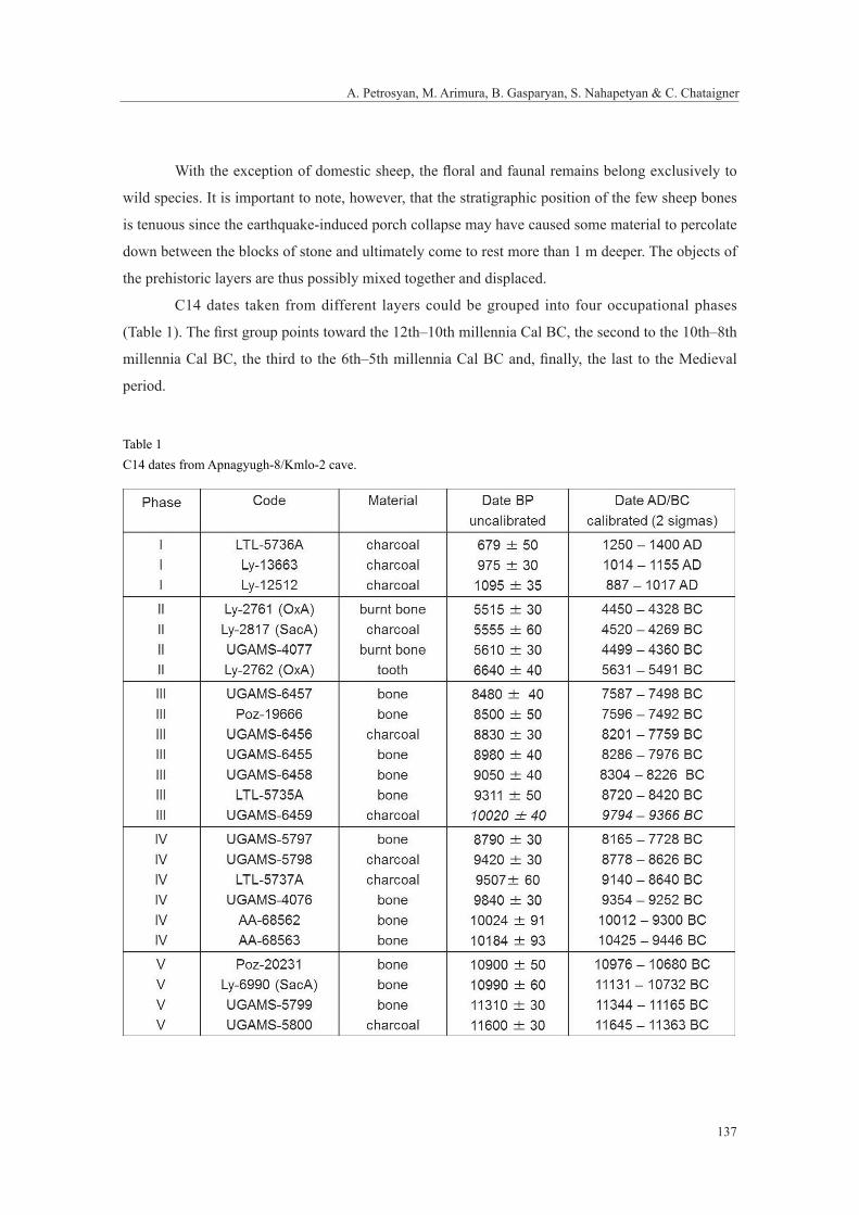
C14 dates taken from different layers could be grouped into four occupational phases
(Table 1). The fi rst group points toward the 12th–10th millennia Cal BC, the second to the 10th–8th
millennia Cal BC, the third to the 6th–5th millennia Cal BC and, fi nally, the last to the Medieval
period.
Table 1C14 dates from Apnagyugh-8/Kmlo-2 cave.
Early Holocene sites of the Republic of Armenia: Questions of cultural distribution and chronology
138
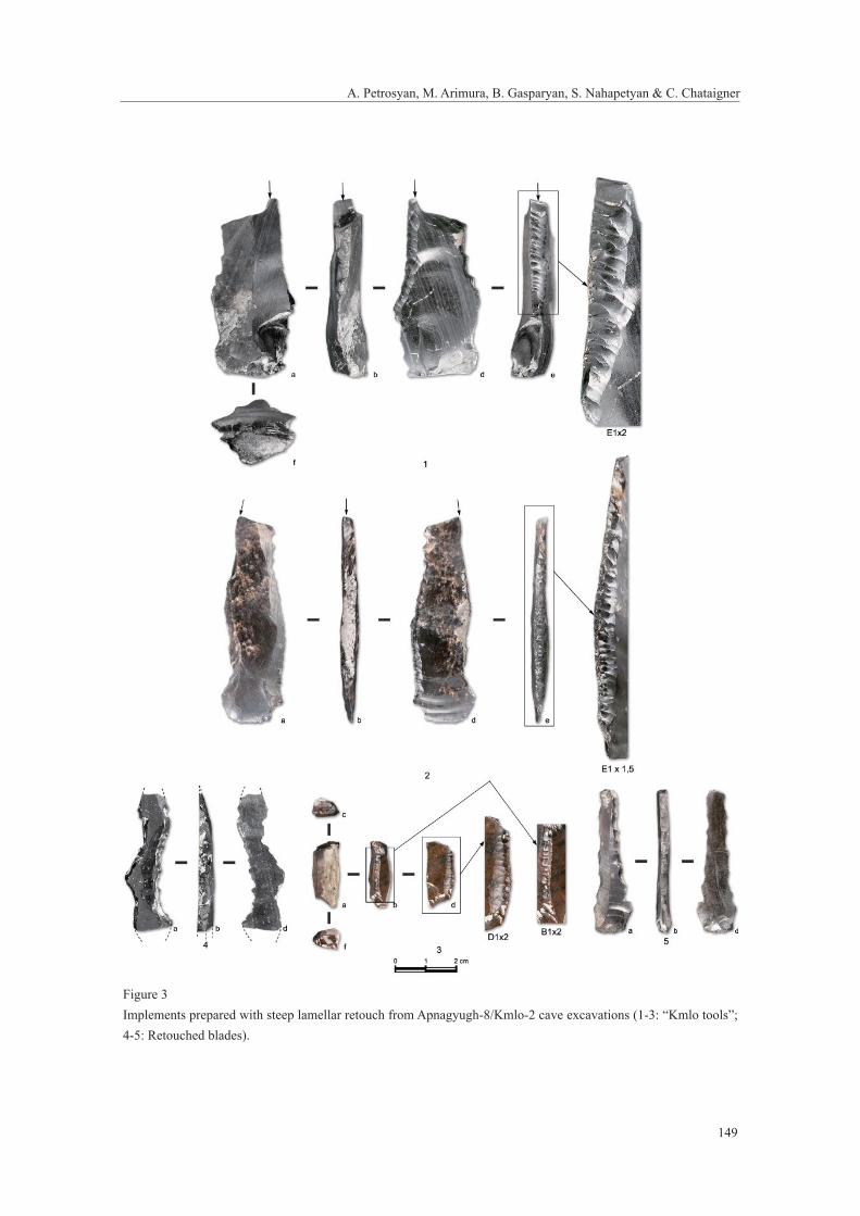
The lithic industry tends to confi rm this partition into three early phases of occupation:
- The most frequent types of microliths are the backed bladelets and scalene (straight-
backed and obliquely truncated) bladelets that recall those of the Late Upper
Paleolithic tradition of Kalavan-1 and the Mesolithic sites of the 10th to 9th millennia
BC in Georgia, for example at Kotias Klde (Meshveliani et al. 2007; Montoya et al.
2013);
- So-called “Kmlo tools”, which are defi ned as having lamellar parallel retouch, created
by pressure flaking that forms a steeply-angled edge with a dentate outline. The
position of retouche occurs on both the dorsal and ventral faces. The retouch often
terminates before the proximal end, which has the form of a hook or two accentuated
ridges (Figure 3). Similar tools are known from sites the Pre-pottery Neolithic (8th
to 7th millennia BC) of both the Near East and north-western Caucasia. These tools
are also present from at least the fi rst half of the 9th millennium BC at Apnagyugh-8/
Kmlo-2 cave (Figure 3);
- Transverse arrowheads are characteristic of the Late Neolithic and the Chalcolithic of
a very large region, as they appear in the Near East at the end of the 7th millennium
BC (Sabi Abyad in Syria) and spread then over the northern part of the Near East and
into southern Europe (Copeland and Akkermans 1994; Wechler 2001). In Armenia, a
large number of transverse arrowheads have been found at a late 5th millennium BC
site (Tsaghkahovit-1 rock-shelter) located not far from Apnagyugh-8/Kmlo-2 on the
northern fl ank of Mt. Aragats (Arimura et al. 2012).
Regardless of the cultural phase, all of the lithic artifacts of Apnagyugh-8/Kmlo-2 share
some common features:
a) Obsidian is almost exclusively the raw material used: more than 6,000 pieces are in
obsidian, other raw materials such as fl int and dacite are quite few;
b) Cores are generally small; the main core reduction strategy was based on
unidirectional knapping with direct percussion;
c) The microlithic component is predominant; some larges blades, more than 2 cm wide
and 10 cm long, are present but very rare.
The site of Apnagyugh-8/Kmlo-2 demonstrates the presence of human groups at the
beginning of the Holocene in the region of the Aragats massif. With a cave occupation and a tool
kit of microlithic tradition, the culture represented at Apnagyugh-8/Kmlo-2 could be related to
the Mesolithic. But a particular category of artifacts (the “Kmlo tools”), with abrupt and regular
139
A. Petrosyan, M. Arimura, B. Gasparyan, S. Nahapetyan & C. Chataigner
pressure retouch, is reminiscent of both the “Çayönü tools”, present in northern Mesopotamia
between the 8th and the 7th millennia BC and the “hook-like tools” of the “Paluri-Nagutny” culture
which developed on the south-west fl ank of the Greater Caucasus and then on the high plateaus of
southern Georgia in later periods (Grigolia 1977; Caneva et al. 1998). The relations between Kmlo-
2 and these cultures will be the subject of a further study.
Further research should be especially focused on Early Holocene sites, which will enable
a better understanding of the human occupation of Armenia in this period as well as the process of
fl oral and faunal domestication in the southern Caucasus (Chataigner et al. 2012, p. 57).
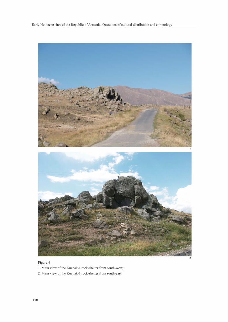
3. Kuchak-1 rock-shelterKuchak-1 rock-shelter is located north-еаst of the village for which it is named at the northern
bank of the Aparan Reservoir at an elevation about 1855 m asl. It is a small natural cavity (12 × 6
× 2 m) that was formed on the western edge of the Aragats Mountain. It lies at the junction of the
Kasakh River and one and its tributaries on a weathered Upper Pleistocene andesitodacite fl ow. It is
possible that a cave existed prior to the collapse of the entrance (Figure 4).
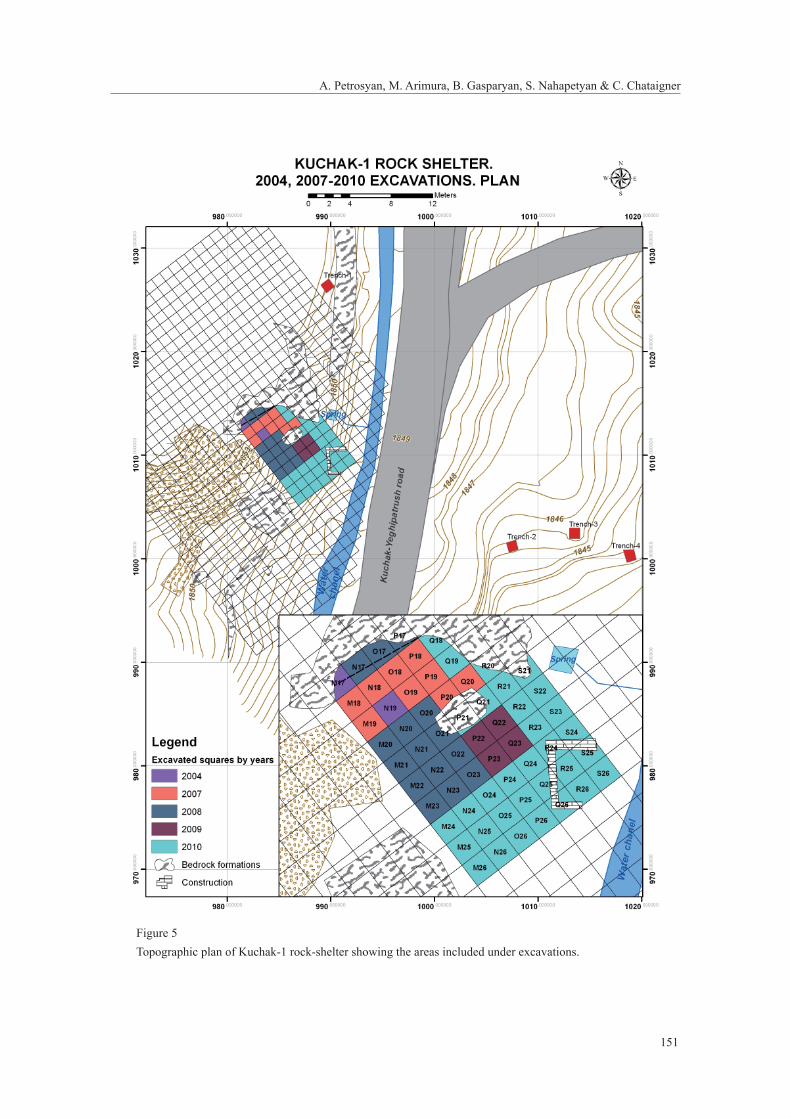
The site was discovered and studied in 2004 by an Armenian-French joint expedition.
Systematic excavations at the site began in 2007. During the 2007-2010 seasons the expedition of
the Institute of Archaeology and Ethnography (directed by B. Gasparyan) excavated an area around
60 m2 under the shelter and on the slope in front of the rock-shelter. Test trenches were also set up
on the opposite side of the modern road passing directly across the site to defi ne the limits of the
occupation (Figure 5).
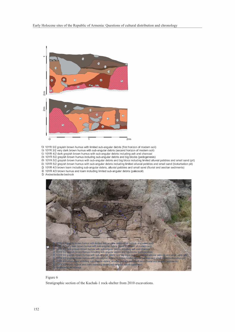
The following statigraphy of the geological horizons or layers were identifi ed (from the top
to the bottom, Figure 6):
Layer 1. Modern soil, overall thickness averages 0.35 m , which is subdivided into three
horizons;
1a: Grayish brown (10YR 5/2) humus with limited sub-angular debris (fi rst horizon of
modern soil 0.20 m)
1b: Very dark brown (10YR 3/2) humus with sub-angular debris (second horizon of
modern soil, 0.10 m)
1c: Dark grayish brown (10YR 4/2) humus with sub-angular debris and ash and
charcoal (third horizon of modern soil, 0.06 m).
Layer 2. Second layer of humus, overall thickness averages 0.20 m, which is subdivided
into:
Early Holocene sites of the Republic of Armenia: Questions of cultural distribution and chronology
140
2a: Grayish brown (10YR 5/2) humus including sub-angular debris and big blocks
(pedogenesis), 0.08 m;
2b: Grayish brown (10YR 5/2) humus with sub-angular debris and big blocks,
including limited alluvial pebbles and small sand (pit), 0.07 m;
2c: Grayish brown (10YR 5/2) humus with sub-angular debris, including limited
alluvial pebbles and small sand (bioturbation pit), 0.05 m;
Layer 3. Brown (10YR 4/3) loam, including sub-angular debris, alluvial pebbles, and
small sand (fl uvial and aeolian sediments, 0.25 m);
Layer 4. Brown (10YR 4/3) humus and loam, including limited sub-angular debris
(paleosol, 0.20 m);
Layer 5. Andesitedacite bedrock.
The total thickness of sediments in the excavated areas is between 0.20–1.01 m. The
full sequence of deposition exists in only a few of the excavation squares (Figures 6 and 7: 2),
as bedrock lies close to the surface along most of the excavated areas. The formation of Layer
1 probably occurred in the Late Holocene while Layer 2 was likely formed during the Early
Holocene. Layer 3 most probably belongs to the Younger Dryas and marks a boundary between
Pleistocene and Holocene of the Aparan Depression. The layer was formed in conditions of
noticeable climatic displacements (from dry and cold to warm and humid) and rapid change of local
paleoenvironment. The timing of formation of Layer 4 is Late Pleistocene, which is confi rmed by
the existence of late Middle Paleolithic artifacts. The excavations here recorded noticeable density
of cultural remains from different periods.
Most of Early Holocene cultural remains originate from Layers 2 and 3. Layer 1 contains
many pottery fragments from the Medieval Period (4th–13th centuries AD) and Late Bronze
Age (15th/14th–13th centuries BC) in addition to trash and other indicators of recent activity.
Unfortunately, the recent, Medieval, and Bronze Age activities disturbed most of the in situ
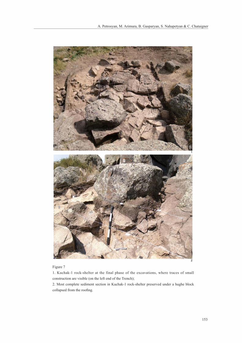
deposition of the cultural remains of the Early Holocene. Early Holocene populations were also
responsible for disturbing earlier occupations, as pits and other constructions passed into the Middle
Paleolithic cultural remains in Layer 4. The stone construction discovered in front of the shelter is
very poorly preserved and heavily damaged by recent activities. However, this is the earliest such
phenomenon yet recorded in Armenia, which shows that artifi cial structures in front of caves date to
at least the Early Holocene (Figure 7: 1). In sum, the stratigraphic position of the cultural remains is
relatively clear and their distribution is in agreement with the geological stratigraphy of the site.
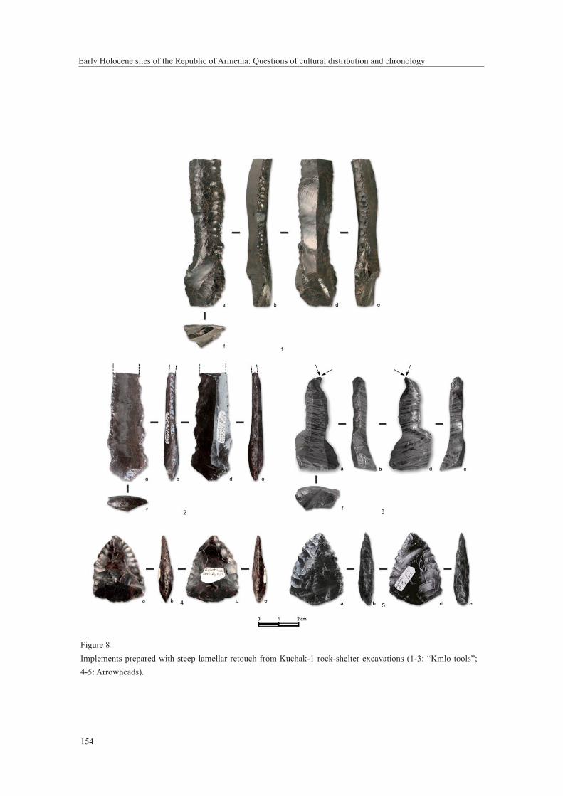
The lithic industry, represented by over 3,000 stone implements, originates mainly from
141
A. Petrosyan, M. Arimura, B. Gasparyan, S. Nahapetyan & C. Chataigner
layers 2a to 4 and is a result of activity of Early Holocene and Middle Paleolithic populations. The
artifacts are prepared mainly from obsidian. Implements from other types of raw materials (basalt,
andesite, dacite, limestone, etc.) are rare and are represented by natural pebbles and cobbles, which
served mainly as hammer-stones and retouchers. Two examples of serdolite beads and a fragment
of “shaft-straightener” from andesitic basalt are also present among the materials. The obsidian
implements of the Early Holocene period represent a single industry. Cores are knapped from
obsidian pebbles of various sizes that were washed by the Kasakh River from the Tsaghkunyats
sources. The class of cores are single-platform unifacial, double-platform unifacial, and discoidal
as well, proto-prismatic and prismatic, which corresponds to the products of knapping (large and
massive fl akes and blades, small and thin bladelets of different shapes) and the tools based on them.
Among the tool assemblage retouched flakes and blades, scrapers, naturally backed
knives, burins, notched and denticulated tools, harpoons, asymmetric and simple points,
arrowheads, geometric microliths, and backed bladelets are all present. The most significant are
the aforementioned “Kmlo tools”. They are manufactured on thick, elongated flakes with an
application of steep lamellar retouch on the ventral side of the artifact with pressure technology
(Figure 8). Other examples are well known from the synchronous sites of the Aparan Depression
and other areas of Armenia (Chataigner et al. 2007, pp. 31-32; Arimura et al. 2009; 2010, pp. 77-
80). It is interesting to note that in the Kuchak collection there are other categories of tools, mainly
arrowheads, that are also formed with steep lamellar pressure retouch, which suggests that this
technique was used for purposes other than the shaping of these “Kmlo tools” (Figure 8). It is
important to mention that a limited number of poorly preserved faunal remains, among which wild
sheep, goat, and roe dear were identifi ed, were also found in situ (some inside of the construction)1.
4. Gegharot-1 open-air siteGegharot-1 is an open-air site on the eastern suburbs of the eponymous village, on the southern
slope of the Pambak Range at the elevation about 2127 m asl. The site was discovered in 2002 by
an Armenian-French joint expedition during a systematic survey in the Kasakh River valley (Arimura
et al. 2009, p. 19). It is located on the slope of small hill, which is a heavily weathered intrusive
granite massif of Paleocene ege. In small ravines, spread on the right and left sides of the hill, peat-
bog formations can be observed, some of which are covered with alluvial sediments composed of
1. We gratefully acknowledge Prof.-Dr. H.-P. Uerpmann (University of Tübingen, Germany) and Dr. Guy Bar-Oz (Laboratory
of Archaeozoology, Zinman Institute of Archaeology, University of Haifa), who identifi ed the faunal remains.
Early Holocene sites of the Republic of Armenia: Questions of cultural distribution and chronology
142
weathered granite sand. The site itself probably occupied the top of the hill during the early stages
of Holocene pedogenesis. Afterwards, as a result of slope activitation, the occurrence of cultural
remains were disturbed, and later buried at different levels of soil or on the eroded surface.
More than 100 lithic artifacts in total were collected from the surface and the eroded parts
of the soil cover.
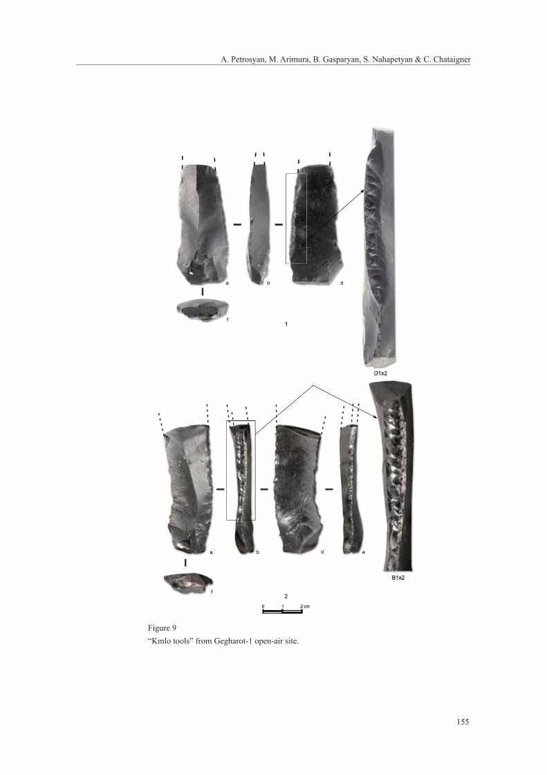
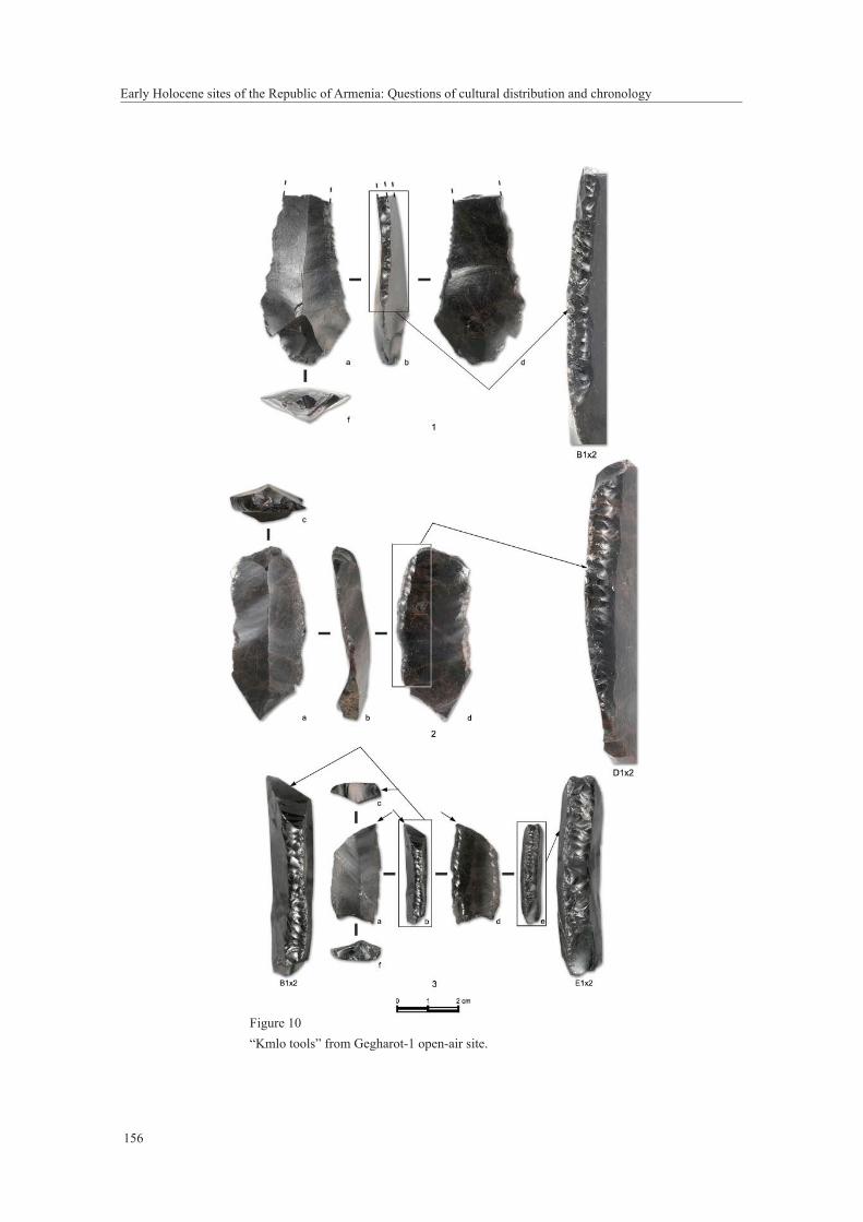
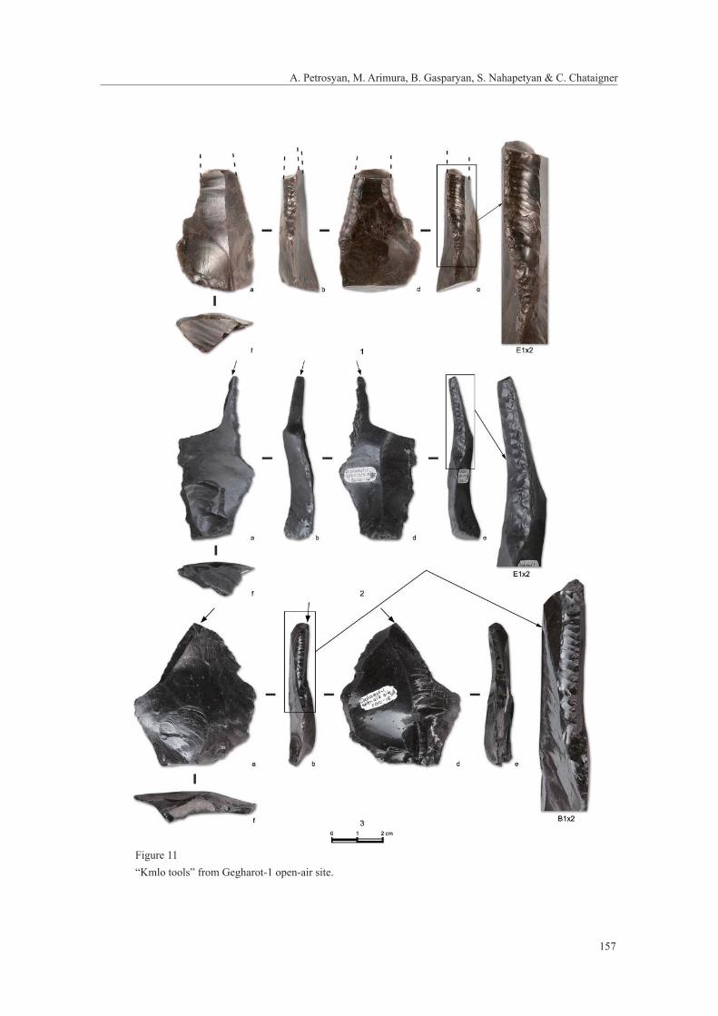
The lithic industry is based mainly on obsidian (around 90%) and the tools made of other
raw materials (quartzite, basalt, dacite, flint) are unique. In the small collection of Gegharot-1
there are pieces quite similar to the ones from the Apnagyugh-8/Kmlo-2 industry – “Kmlo tools”
(the most characteristic artifact of the collection, around 17 pieces), pressure detached bladelets,
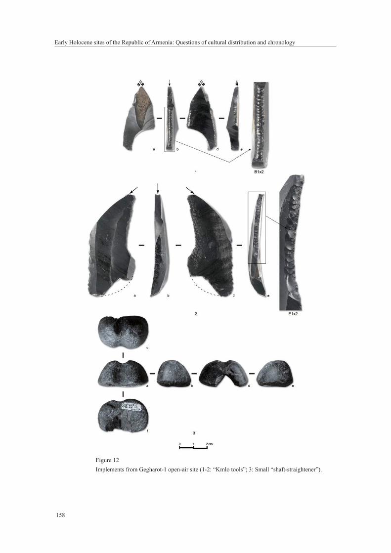
geometric microliths, end scrapers, and burins. The “Kmlo tools” (Figures 9-12) from Gegharot-1
are characterized as follows:
- Blanks: all pieces are made on simple large blades, around 20 mm wide and 8 mm
thick.
- Abrasion trace: This is a common character among “Kmlo tools” from Gegharot-1.
Abrasions typically occur opposite the retouched faced. In general, abrasion traces
are well developed in a band but, in some cases, very slight abrasion traces also exist
on the ventral face. The abrasion traces were created prior to the pressure retouche, as
they are cut through by the latter.
- Edge modifi cation: This is also a common character in Gegharot-1. The lateral edge is
often modifi ed by burin blow, and a spall removed from a “Kmlo tool” is present in
the collection. Truncation of the end(s) is also often observed.
As mentioned above, the function of “Kmlo tool” is yet uncertain, but some were probably
used for hard mineral working. In the collection there is a fl ake tool with traces of abrasion, which
indicates that some mineral working was an important activity in Gegharot-1 (Figure 12: 2). Among
the most interesting fi nds from Gegharot-1 is a small “shaft-straightener” made from serpentine,
which, together with a similar fi nd from Kuchak-1 rock-shelter, are the oldest examples of such
artifacts from all of Armenia (Figure 12: 3).
There are limited finds of faunal remains from Gegharot-1 in the context of the lithic
implements, represented by teeth of kulan or Equus hemionus (identifi cations of H.-P. Uerpmann).
Based on the techno-typological characteristics of the “Kmlo tools”, the Gegharot-1
collection can be attributed to the Early Holocene, possibly contemporary with the sites mentioned
above in the Aparan Depression (Apnagyugh-8/Kmlo-2 cave, Kuchak-1 rock-shelter and the
others).
143
A. Petrosyan, M. Arimura, B. Gasparyan, S. Nahapetyan & C. Chataigner
5. Concluding remarksThe investigations of the last decade have brought to light the first known Mesolithic and/
or Proto-Neolithic sites dating to the Early Holocene in Armenia. These sites are concentrated
within the limits of the Aparan Depression and the Kasakh River valley (Apnagyugh-8/Kmlo-
2 cave, Kuchak-1 rock-shelter, Gegharot-1, Ria-Taza-2, Aragats-1 and 2 open-air sites). Other
such sites have been discovered on the southern slopes of Mt. Aragats in the Ararat Depression
(Aruch-1, Vahagni-1, Satani-Dar, Ashnak-1 and Katnaghbyur-1 open-airs), the Shirak Depression
(Shirakavan-1, Aghvorik-1 open-airs), the Lori Depression (Kruglaya-Shishka-1 cave,
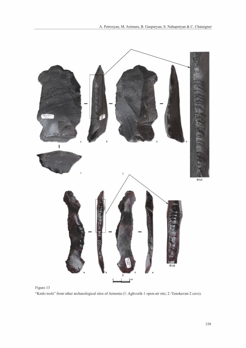
Paghaghbyur-1 open-air site), the Aghstev River valley (Yenokavan-2 cave), and others, and “Kmlo
tools” are common implements among the products of the lithic industries (Figure 13) (Gasparyan
and Sargsyan 2003; Gasparyan 2007; Gasparyan et al. 2005; Yeritsyan et al. 2009). Preliminary
investigations of those sites reveal the existence of very small, mobile groups of Early Holocene
hunters and gatherers who occupied caves and rock-shelters in the river canyons as well as river
terraces and plateaus in high mountain depressions. While rich with lithic assemblages that show
the exploitation of various obsidian sources, the relatively thin cultural deposits of these sites lack
rich bioarchaeological information. Nevertheless, the limited bioarchaeological materials, together
with toolkit composition, suggest hunting of wild species (sheep, goat, deer, and kulan), fi shing,
and collecting wild plants. Signs of domestication and a food producing economy are largely
absent, which precludes the placement of these Early Holocene sites in the frame of the Neolithic
but, rather, necessitates their consideration as Mesolithic and/or Proto-Neolithic with a time
range of 12,000–7,500 Cal BC (based on a preliminary set of radiocarbon dates). This provides a
chronological problem and cultural gap between these Early Holocene sites and the Late Neolithic
sites (the so-called “Aratashen-Shulaveri-Shomutepe” culture).
The lithic assemblages of the Early Holocene sites are characterized by a large number
of geometric microliths (scalene, trapeze-rectangles) as well as very special tools with continuous
parallel retouch on the lateral edges executed by pressure fl aking technology. These unique artifacts,
called “Kmlo tools”, mark the cultural specifi cation of the time period. They have visual similarities
with the so-called “Çayönü tools” known from the Near Eastern Pre-pottery Neolithic sites, but are
different in many respects from the latter’s techno-morphological designing concept and appear in
Armenia at least from the fi rst half of the 9th millennium BC. The functional purpose of these “Kmlo
tools” is not yet clear. Similar tools with secondary shaping have been found in Early Holocene
caves and Neolithic settlements of the Caucasus and regions of the Near East dated to the 8th to
7th millennia BC (Мortensen 1970; Redman 1982; Fujii 1988; Bader 1989; Bader and Tseretelli
Early Holocene sites of the Republic of Armenia: Questions of cultural distribution and chronology
144
1989; Anderson 1994; Balkan-Atlı 1994; Caneva et al. 1994; Rosenberg 1999; Nishiaki 2000;
Kozlowski and Aurench 2005, pp. 65-73; Cauvin et al. 2011, pp. 6-7, 11, 29, 35). As mentioned
before, research on “Kmlo tools” shows that the working edges are very often removed or refreshed
with the method of a burin blow, thus this kind of tool was rarely re-retouched and reformed into a
previous shape of tools.
Although our investigations of these sites have provided the first evidence for terminal
Pleistocene/Early Holocene sites in Armenia, many aspects in this period, such as subsistence
economy and social organization, are still unclear. New excavations of “Kmlo type” sites, especially
ones with richer bioarchaeological sequences, which are likely to be located in the northern karstic
environments of Armenia that are conducive to the preservation of organic materials, are important
future tasks for Armenian archaeology.
ReferencesAnderson, P. (1994) Refl ection on the signifi cance of two PPN typological classes in light of experimentation and
microware analyses: Flint “Sickles” and obsidian “Çayönü” tools. In: Gebel, H.G.G. and Kozlowski, S.K. (eds.),
Neolithic chipped stone industries of the Fertile Crescent. Berlin: ex orient, pp. 61–82.
Arimura, M., Chataigner, C. and Gasparyan, B. (2009) Kmlo-2, An Early Holocene Site in Armenia. Neo-Lithics
2/2009, pp.17–19.
Arimura, M., Badalyan, R., Gasparyan, B. and Chataigner, C. (2010) Current Neolithic Research in Armenia. Neo-
Lithics 1/2010, pp. 77–85.
Arimura, M., Gasparyan, B. and Chataigner, C. (2012) Prehistoric sites in Northwest Armenia: Kmlo-2 and
Tsaghkahovit. In: Matthews, R. and Curtis, J. (eds.), Proceedings of the 7th International Congress of the
Archaeology of the Ancient Near East, 12 April – 16 April 2010, The British Museum and UCL, London,
Volume 3: Fieldwork and Recent Research Posters. Glatz C., Simpson St.J., Taylor H., Tubb J. and
Chapman R., Wiesbaden: Harrassowitz Verlag, pp. 135–149.
Badalyan, R., Lombard, P., Avetisyan, P., Chataigner, Ch., Shabot, J., Vila, E., Hovsepyan, R., Willcox, G. and
Pessin, H. (2007) New Data on the Late Prehistory of the Southern Caucasus. The excavations at Aratashen
(Armenia): Preliminary report. In: Lyonnet, B. (ed.), Les Cultures du Caucase (VIe–IIIe Millénaires avant
notre ère). Leurs relations avec le Proche Orient. Paris: CNRS Editions, pp. 37–61.
Bader, N.O. (1989) Drevneyshiye zemledel’tsi Severnoy Mesopotamii (Ancient farmers of the Northern
Mesopotamia). Moscow: “Nauka” Publishing House (in Russian).
Bader, N.O. and Tseretelli, L.D. (1989) Mezolit Kavkaza (The Mesolithic of the Caucasus). In: Kol’tsov, L.V. (ed.),
Mesolithic of USSR. Archaeology of the USSR series. Moscow: “Nauka” Publishing House, pp. 93–105 (in
Russian).
145
A. Petrosyan, M. Arimura, B. Gasparyan, S. Nahapetyan & C. Chataigner
Balkan-Atlı N. (1994) La Néolithisation de l’Anatolie. Varia Anatolica VII. Paris: Institut français d’études
anatoliennes d’Istanbul.
Caneva, I., Conti, A., Lemorini, C. and Zampetti, D. (1994) The lithic industry at Çayönü: A Preliminary Overview
of the Aceramic Sequence. In: Gebel, H.G. and Kozlowski, S.K. (eds.), Neolithic Chipped Stone Industries of
the Fertile Crescent. Berlin: ex orient, pp. 253–266.
Caneva, I., Lemorini, C. and Zampetti, D. (1998) Chipped stone at Aceramic Çayönü: Technology, Activity,
Tradition, Innovations. In: Arsebuk, G, Mellink, M.J. and Schirmer, W. (eds), Light on top of the Black Hill.
Studies presented to Halet Cambel. Istanbul: Ege Yayinlari, pp. 199–206.
Cauvin, J., Arenche, O., Cauvin, M.-C. and Balkan-Atlı, N. (2011) The Pre-Pottery Site of Cafer Höyük. In:
Başgelen N., Özdoğan M., Kuniholm P. (eds.), The Neolithic in Turkey: New Excavations & New Research
volume 2. The Euphrates Basin. Istanbul, Galatasaray: Archaeology & Art Publications, pp. 1–40.
Chataigner, C., Arimura, M. and Gasparyan, B. (2007) La néolithisation de L’Arménie. Les Dossiers d’archéologie
N321, pp. 30–35.
Chataigner, C., Gasparyan, B., Montoya, C., Arimura, M., Melikyan, V., Liagre, J., Petrosyan, A., Ghukasyan,
R., Colonge, D., Fourloubey, K., Arakelyan, D., Astruc, L., Nahapetyan, S., Hovsepyan, R., Balasescu, A.,
Tome, K. and Radu, V. (2012) From the Late Upper Palaeolithic to Neolithic in North-Western Armenia:
Preliminary results. In: Avetisyan, P. and Bobokhyan, A (eds.), Archaeology of Armenia in Regional Context,
Proceedings of the International Conference dedicated to the 50th Anniversary of the Institute of Archaeology
and Ethnography Held on September 15-17, 2009 in Yerevan. Yerevan: National Academy of Sciences of the
Republic of Armenia “Gitutyun” Publishing House, pp. 52–63.
Copeland, L. and Akkermans, P.M.M.G. (1994) A cache of 56 fl int transverse arrowheads from Tell Sabi Abyad,
Balikh valley, Syria. In: Gebel, H.G. and Kozlowski, S.K. (eds.), Neolithic Chipped Stone Industries of the
Fertile Crescent. Proceedings of the First Workshop on PPN Chipped Lithic Industries. Berlin: ex oriente, pp.
379–382.
Fujii, S. (1988) Typological Reassessment and Some Discussions on “Beaked Blades”. Bulletin of the Okayama
Orient Museum 7, pp. 1–16.
Gasparyan, B. and Sargsyan, G. (2003) Kasakhi kirchi hnagitakan hushardzanneri usumnasirutyan nakhnakan
ardyunknery (Preliminary results of investigation of the archaeological monuments in the Kasakh River
Canyon). In: The Jubilee Conference “Aragatsotn. Spiritual and Cultural Heritage”, dedicated to the 1700th
anniversary of the unction of the Mother Temple of Holy Ejmiatsin. Theses of the Conference. Oshakan, pp.
58−59 (in Armenian).
Gasparyan, B. (2007) Dans les montagnes d’Arménie, 500 000 ans d’histoire avant notre ére. Fichet de
Clairfontaine, F. (ed.). Rouen: Musée archéologique de Saint-Raphael; Musée départemental des antiquités, pp.
47–51, 130–133.
Gasparyan, B., Nahapetyan, S., Sargsyan, G. and Gabrielyan, I. (2005) Kamenniy vek Tashirskogo plato (The
Stone Age of the Tashir Plateau). In: Kalantaryan, A.A., Badalyan, R.S. and Avetisyan, P.S. (eds.), Hin
Early Holocene sites of the Republic of Armenia: Questions of cultural distribution and chronology
146
Hayastani mshakuyty XIII (The Culture of Ancient Armenia XIII). Materials of the Republican conference.
Yerevan: “Mughni” Publishing House, pp. 17–27 (in Russian).
Grigolia, G.K. (1977) Neolit Tsentral’noy Kolkhidi. Paluri (The Neolithic of Central Kolkhida. Paluri). Tbilisi:
“Metsniereba” Publishing House (in Georgian with Russian Resume).
Kozlowski, S.K. and Aurenche, O. (2005) Territories, Boundaries and Cultures in the Neolithic Near East. BAR
International Series 2005. Oxford: Archaeopress.
Meshveliani, T., Bar-Oz, G., Bar-Yosef, O., Belfer-Cohen, A., Boaretto, E., Jakeli, N., Koridze, I. and Matskevich, Z.
(2007) Mesolithic hunters at Kotias klde, Western Georgia: Preliminary results. Paléorient 33/2, pp. 47–58.
Montoya, C., Balasescu, A., Joanin, S., Ollivier, V., Liagre, J., Nahapetyan, S., Ghukasyan, R., Colonge, D.,
Gasparyan, B. and Chataigner, C. (2013) The Upper Paleolithic site of Kalavan-1 (Armenia): An Epigravettian
settlement in the Lesser Caucasus. Journal of Human Evolution 65, pp. 621–640.
Mortensen, P. (1970) Tell Shimshara, The Hassuna period. Kobenhavn.
Nishiaki, Y. (2000) Lithic technology of Neolithic Syria. BAR international series 850. Oxford.
Rosenberg, M. (1999) Hallan Çemi. In: Özdoğan, M. and Başgelen, N. (eds.), Neolithic in Turkey. The cradle of
civilizations. New Discoveries. Istambul: Arkeoloji ve Sanat Yayinlari, pp. 9–18, 25–33.
Redman Ch.L. (1982) The Çayönü Tepesi chipped stone industry: 1968 and 1970 excavation seasons. In:
Braidwood, L.S. and Braidwood. R.J. (eds.), Prehistoric village Archeology in South-Eastern Turkey. BAR
International Series 138. Oxford, pp. 17–71.
Wechler, K.P. (2001) Studien zum Neolithikum der osteuropäischen Steppe. Mainz: von Zabern.
Yeritsyan, B., Petrosyan, A. and Gasparyan, B. (2009) Vahagni-1 karedaryan batsotya hnavayri usumnasirutyan
nakhnakan ardyunknery (Preliminary results of investigation of Vahagni-1 Stone Age open-air Site). In:
Collection of Scientifi c articles, Yerevan-2, Scientifi c session dedicated to the key issues of Yerevan history.
Yerevan: Yerevan History Museum Press, pp. 33–39 (in Armenian).
147
A. Petrosyan, M. Arimura, B. Gasparyan, S. Nahapetyan & C. Chataigner
Figure 11. Main view of the Kasakh River at its junction with tributary where Apnagyugh-7 and 8/Kmlo-1 and 2 caves are situated;2. Main view of the Apnagyugh-8/Kmlo-2 cave from south-east.
Early Holocene sites of the Republic of Armenia: Questions of cultural distribution and chronology
148
Figure 2Topographic plan and stratigraphic section (2005 excavations) of Apnagyugh-8/Kmlo-2 cave.
149
A. Petrosyan, M. Arimura, B. Gasparyan, S. Nahapetyan & C. Chataigner
Figure 3Implements prepared with steep lamellar retouch from Apnagyugh-8/Kmlo-2 cave excavations (1-3: “Kmlo tools”; 4-5: Retouched blades).
Early Holocene sites of the Republic of Armenia: Questions of cultural distribution and chronology
150
Figure 41. Main view of the Kuchak-1 rock-shelter from south-west;2. Main view of the Kuchak-1 rock-shelter from south-east.
151
A. Petrosyan, M. Arimura, B. Gasparyan, S. Nahapetyan & C. Chataigner
Figure 5Topographic plan of Kuchak-1 rock-shelter showing the areas included under excavations.
Early Holocene sites of the Republic of Armenia: Questions of cultural distribution and chronology
152
Figure 6Stratigraphic section of the Kuchak-1 rock-shelter from 2010 excavations.
153
A. Petrosyan, M. Arimura, B. Gasparyan, S. Nahapetyan & C. Chataigner
Figure 71. Kuchak-1 rock-shelter at the final phase of the excavations, where traces of small construction are visible (on the left end of the Trench);2. Most complete sediment section in Kuchak-1 rock-shelter preserved under a hughe block collapsed from the roofi ng.
Early Holocene sites of the Republic of Armenia: Questions of cultural distribution and chronology
154
Figure 8 Implements prepared with steep lamellar retouch from Kuchak-1 rock-shelter excavations (1-3: “Kmlo tools”; 4-5: Arrowheads).
155
A. Petrosyan, M. Arimura, B. Gasparyan, S. Nahapetyan & C. Chataigner
Figure 9“Kmlo tools” from Gegharot-1 open-air site.
Early Holocene sites of the Republic of Armenia: Questions of cultural distribution and chronology
156
Figure 10“Kmlo tools” from Gegharot-1 open-air site.
157
A. Petrosyan, M. Arimura, B. Gasparyan, S. Nahapetyan & C. Chataigner
Figure 11“Kmlo tools” from Gegharot-1 open-air site.
Early Holocene sites of the Republic of Armenia: Questions of cultural distribution and chronology
158
Figure 12Implements from Gegharot-1 open-air site (1-2: “Kmlo tools”; 3: Small “shaft-straightener”).
159
A. Petrosyan, M. Arimura, B. Gasparyan, S. Nahapetyan & C. Chataigner
Figure 13“Kmlo tools” from other archaeological sites of Armenia (1: Aghvorik-1 open-air site; 2: Yenokavan-2 cave).