Embed Size (px)
Citation preview
University of Massachusetts AmherstScholarWorks@UMass AmherstLandscape Architecture & Regional PlanningMasters Projects Landscape Architecture & Regional Planning
2005
Stormwater Management Trends: A review of tools,techniques and methods for design anddevelopment of the land with implications forsustainable designWilliam C. [email protected]
Follow this and additional works at: https://scholarworks.umass.edu/larp_ms_projects
Part of the Landscape Architecture Commons
This Article is brought to you for free and open access by the Landscape Architecture & Regional Planning at ScholarWorks@UMass Amherst. It hasbeen accepted for inclusion in Landscape Architecture & Regional Planning Masters Projects by an authorized administrator of ScholarWorks@UMassAmherst. For more information, please contact [email protected].
Cone, William C., "Stormwater Management Trends: A review of tools, techniques and methods for design and development of theland with implications for sustainable design" (2005). Landscape Architecture & Regional Planning Masters Projects. 11.Retrieved from https://scholarworks.umass.edu/larp_ms_projects/11

STORMWATER MANAGEMENT TRENDS
A REVIEW OF TOOLS, TECHNIQUES AND METHODS FOR DESIGN AND
DEVELOPMENT OF THE LAND WITH IMPLICATIONS FOR SUSTAINABLE DESIGN
A Master’s Project Presented
By
WILLIAM C. CONE, ASLA
Submitted to the Department of Landscape Architecture and Regional Planning of the University of Massachusetts Amherst in partial fulfillment of the requirements for the
degree of
MASTER OF LANDSCAPE ARCHITECTURE June 2005
Master’s Program in Landscape Architecture

STORMWATER MANAGEMENT TRENDS
A REVIEW OF TOOLS, TECHNIQUES AND METHODS FOR DESIGN AND
DEVELOPMENT OF THE LAND
A Master’s Project Presented
By
WILLIAM C. CONE, ASLA Approved as to style and content by:
Mark Linhult, Chair
Paul Barten, Member
John F. Ahern, Department Head Landscape Architecture and Regional Planning

CONTENTS
Acknowledgments
Chapter 1: Introduction
1.0 Introduction 1
1.1 Humans and Stormwater 3
1.2 Urbanization and Stormwater 4
1.3 Conventional Stormwater Practices 8
1.4 Importance of Water 9
1.5 Summary: Some Progress 11
Chapter 2: Literature Review
2.0 Introduction 14
2.1 Alternative Stormwater Technologies and Practice 14
2.2 Stormwater and Permitting 21
2.3 Alternative Landscape Technologies 26
2.4 Design and Communication Technologies 37
2.5 Summary 41
Chapter 3: Methods
3.0 Introduction 42
3.1 Literature Review 43
3.2 Case Studies 43
3.3 Summary 45
Chapter 4: Case Studies
4.0 Introduction 46
4.1 Case Study One 48
4.2 Case Study Two 59
4.3 Case Study Three 79
4.4 Case Study Summary 94
Chapter 5: Conclusion and Discussion 97
Citations 103
Appendix A 106

Acknowledgements I would like to acknowledge the help provided to me by my committee. First, to Paul Barten for his infectious excitement about hydrology, his commitment to education and his appreciation for design, and of course his invaluable comments and encouragement during the process. Finally, I owe a deep debt of gratitude to Mark Lindhult for his open minded approach to this project as well as my unique challenge of assembling a graduate curriculum suited to my previous experience and interests. But more importantly, I would like to acknowledge his unwavering patience in dealing with my doubts and concerns throughout the process. I would also like to thank his wife Polly for the many times I invaded their home to discuss the project. Thanks for the iced tea and beers!
I would especially like to thank the individuals and firms that provided valuable billable time to my cause by providing case study information and answers to my many endless questions. Specifically I owe much to the help provided by Jennifer Hamwey, Brett Douglas and James Devellis of Geller Devellis; and Andrea Cooper, Jay Womack and Tom Price, among others, at Conservation Design Forum.
This study could not have been possible without the hard work and dedication of the many nameless individuals, professionals and agencies that have pushed and pulled conventional thinking to create opportunities for alternative methods of stormwater management to begin to become acknowledged by the professions associated with design of the land.
I would also like to extend thanks to my fellow classmates, the MLA graduates of 2005, who offered support and encouragement throughout. Special thanks to Mary Everett for her distinctive brand of insight and friendship. Also, to Greg Tuzzolo who was always patiently there with help on digital technical questions for the online questionnaires and other computer related issues.
I must acknowledge the support of my family during my second time around at the higher education table. First, to my beloved Mother and Father who always encouraged and supported, and now that they are gone from the physical world, have provided me with extra motivation to wring the most out of this short life. And to my dear Brother and Sister who have always stood by and cheered even when I despaired. Also, thanks to Pat, who has helped and continues to help in so many ways that I may never know the true extent of her support or rightly express gratitude.
I also need to recognize the love and support freely given to me by my new life partner, Jo Ann, who took a chance on love during the most tumultuous time in my life.

For designers, new techniques of notation and representation are required. Conventional techniques are inadequate to the portrayal of time and change, and they encourage the continued focus on visible and static form.
Anne Whiston Spirn
CHAPTER 1: INTRODUCTION
1.0 Introduction
The design of stormwater management systems is currently undergoing scrutiny and
revision. This has been a long ongoing process that began to take shape in the late 1980s
following the adoption of new federal regulations controlling discharge of pollutants into water
bodies, rivers and streams. It became apparent after these regulations began to have an affect that
other sources of pollution existed that were less easily pin pointed to a single source. Researchers
and engineers began looking at stormwater as a culprit. This started the federal government to
start to study the source of pollutants that stormwater generates. This corresponded with
revisions to the understanding of ecology as well as deeper richer understanding of the natural
sciences especially the role with which humans play to these systems. The result induced some to
associate not just the contaminants picked up by stormwater to be a major cause of urban stream
degradation but also the way in which the landscape was being transformed by urban
development and the conventional ways that this development accounted for stormwater.
Historically in the United States, stormwater was handled in the small areas where human
settlement occurred. Cities used porous pavements and swales to handle small rain fall events.
As cities grew in size problems associated with where to store water temporarily became more
critical. Also water bourn diseases became a problem. Even before the science was established
what caused some of these diseases, it was understood that water was a culprit and therefore to
protect human health engineers and scientist quickly responded with systems that removed water
from urban centers. These systems worked extremely well and became a major aspect of the
urban infrastructure. Water became associated with a waste product of cities and this approach
exists today with many of the same systems and structures still in use.
1

Over the last 40 or 50 years several important changes have begun to alter the attitude of
drainage design and professional practice. Technology continues to advance rapidly promising
the possibility of better living standards and resolution of problems facing society. Scientific
understanding has advanced and revised ecological paradigms brining on new ways of thinking
about the human relationship with the rest of the biosphere. There have been strides in cleaning
up pollutants through efforts of the Clean Water Act over the past 20 to 30 years. Yet more has
been learned about less visible and more insidious impacts caused by human development. In
response, the concept of sustainable practices has become a consistent presence in science,
engineering, and business.
These changes have created new ways of viewing standard land development practices
such as materials usage, energy efficiency, and water conservation. Stormwater management has
taken on new meaning to designers grappling with ways to mitigate urban development.
Concurrently tools for designing and communicating design and development plans have been
upgraded with the advances in digital technology creating new possibilities and opportunities.
To help understand water quality issues, new computer applications have been developed
and are the basis for the tools still in use today. Designers have a challenge to adapt and meet
new requirements with new applications for new and increasingly complex problems. Therefore
the questions become how will designers respond to theses changes and what will subsist from
traditional practice. Will the complexities of ecologically sensitive design, especially storm
water management, as well as prospects of advancing digital technology create new design
processes? How have tools for mapping hydrologic function changed with understanding of
dynamics of these processes? As Anne Spirn suggests new techniques of notation and
representation may be needed to handle the changes (Spirn 1992). Some approaches to current
problems have advanced rapidly while others remain limited by thinking and practices that have
existed for many years. Perhaps a new methodology should evolve that addresses the new ways
of thinking.
It is at the intersection of the complex issues of digital technology, design process and
stormwater management that this inquiry is focused. An understanding of the problems
associated with urbanized landscapes and its impact on stormwater will set the foundation to this
discussion. The rise of the problem of stormwater issues and the need to make changes will be
2

discussed. As scientists have become aware of these issues, it is important to understand how the
government has responded by updating land use regulations. To bring this into the discussion an
overview of the state of stormwater design from water resource regulatory issues to the digital
tools needed to analyze and design for water. Also many are attempting to bring alternative
landscape technologies for handling stormwater into the forefront and those key initiatives will
be discussed. Finally, a summary review of several examples of recent stormwater related
projects will be included that can offer a view of how the design process is adopting to digital
technology on the upsurge of stormwater design evolution.
The study of the juncture of innovations of water sensitive design, digital technology, and
the design process may offer opportunities for integrating the multiple complexities of design on
the land with ecological processes. The integration between disciplines of design professions
uses multiple media to design and document alternative stormwater management strategies. In
this study, the emphasis will be on the current status of the profession with regard to landscape
technologies for stormwater management and the use of digital technologies to analyze, design
and communicate design intention.
1.1 Humans and Stormwater Engineering design of stormwater systems has provided excellent protection against
flooding and diseases. The prime function of urban drainage has been to protect the health, safety
and welfare of the public. The response from drainage designers over the years has been
provided this basic need. However, as our relationship with natural forces such as water is
evolving so to do we need to evolve the way in which interactions with theses systems function.
Engineering solutions were necessary in a built environment to solve these problems and so we
began to view stormwater as an engineering function.
However, stormwater is not an engineered or a mechanical system. In fact it might be
suggested that stormwater itself is strictly a human concept. Precipitation is a dynamic process of
the natural world. It is the hydrologic cycle that connects the atmosphere, surface water, soils,
vegetation, animals—including humans — together. It restores and connects. It provides
transport of matter and energy and creates disturbances that open possibilities for reactions and
growth to occur. A dynamic equilibrium is created by the existence and movement of water.
3

From water stored or moving through the soil and the microorganisms that thrive to
evapotranspiration of large trees that create enormous pressures on soil moisture. Flows of water
through the soil into streams and wetlands create a baseflow for a watershed that is then
conserved during dry periods to provide minimal moisture for plants and animals in the system.
A healthy system is one that can change gradually. Urban development has changed these
delicate relationships. The rapid increase of impervious surfaces into rural areas and expansion
of cities is causing changes to the earth’s systems. Modifications to the earth’s systems are
happening astronomically fast when compared to the time it took to generate these systems and
processes to begin with. To remedy this will require a better understanding of how to mimic the
dynamics processes.
When considering the urban environment for design, nature is not absent and designs for
human uses should not exclude it. The city is as much about processes, both natural and cultural,
as is the countryside. The city is both natural and artifact (Spirn 1992). Natural processes that
form landscapes and guide development, according to Spirn, should not be objectified as static
elements or features. They are dynamic processes that should be considered as “verbs operating
in a dynamic state” (Spirn 1992). The failure to accommodate these dynamic changes in the
environment may have negative results that cannot be undone (Spirn 2002). Revised thinking
and practices about development of urban forms is under way. There are efforts to change how
humans view and interact with the environment with the advent of green building practices and
sustainable design. Although these efforts like most changes take time, there is hope. If we can
take small, manageable steps to build sustainability into the landscape “which people can
observe, try out, experience, and improve are actually large steps for mankind” (Thayer 1993).
1.2 Urbanization and Stormwater Urban development in the US during the past century has changed land use and
vegetation characteristics dramatically causing increased impervious surfaces and reduction in
pre-settlement conditions. The removal of vegetation that once intercepted rainfall, landforms
that took thousands of years to create are made uniform, ancient soils profiles are homogenized
or eroded. Introduction of urbanized development such as rooftops, roads, driveways, parking
lots and sidewalks have created conditions where imperviousness dominates the landscape and
4
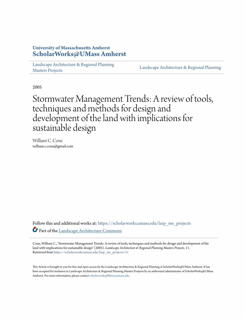
precipitation is converted to surface flows. A direct relationship exists between increases in
impervious surfaces and surface flow (see Figure 1).
RELATIONSHIP BETWEEN IMPERVIOUS COVER AND SURFACE FLOW FIGURE 1 (CT STORMWATER QUALITY MANUAL 2004)
This relationship in land cover and precipitation pathways has created a situation where
watersheds and their channels have been adversely impacted. Figure 1 illustrates the change that
has been quickly changing the hydrologic cycle and creating conditions that no longer can
support the diversity of life that they once did. The Center for Watershed Protection has reported
that areas that exceed 10% imperviousness stream health begin to decline (Coffman 2002).
Increased flooding, stream bank erosion and pollutant export are among a few of the problems
urban or urbanizing watersheds face. The receiving streams of these intensified storm flows alter
hydraulic characteristics due to peak discharges several times higher than pre-development or
even rural land cover characteristics.
5

Increased volumes from storm events are occurring because more water is leaving the
system causing more frequent and severe flooding. In fact, it is taking less time for surface flow
to reach streams (time of concentration) causing reduced stream flows to extremely low levels
for extended periods simply because the watershed is draining so quickly. Finally, there are
increased surface flow velocities due to a combination of higher peak volumes, reduced time of
concentration and smoother hydraulic surfaces. Resulting increased rates of sediment transport
and deposition, shoreline erosion, channel widening and scour has altered urban stream
morphology and function. Also public health concerns have escalated because of contact with
contaminants in sediment and water. The result of the changes in hydrologic function can be seen
in other areas besides stream morphology and property damage. It also has had severe impacts on
aquatic ecosystems and levels of pollutants, sediments and nutrients entering the watershed from
urban development.
Impervious cover is reflected in stream flow by the rate of speed that water moves
through the watershed. The hydrograph in Figure 2 shows the stark contrast between a vegetated
cover and impervious cover and the effect on stream flows. The impervious cover curve shows
clearly a large spike in the rate of flow during the height of the storm and then diminishes very
quickly as water moves through the system. Whereas the vegetated system curve is long and low
demonstrating the role soil can play in the process. This curve is preceded and followed by a
sustained base flow that contributes to the health of a watershed (Ferguson 1998).
FIGURE 2 (Ferguson 1998)
6

Water does not exist as a pure substance in the biosphere. It carries different compounds
and chemicals depending on its location in the hydrologic cycle, the region on the earth, and time
of year, as well as physical state and temperature among many other factors. This is what it is
supposed to do. However the urbanization trends discussed previously have introduced new
types of water borne constituents. Oils, bacteria, sediment, litter and trash, nutrients, chemicals
from lawns and landscaping, and heavy metals are carried with stormwater into storm drains and
into rivers, streams and wetlands. Automobiles are one of the worst contributors to these high
concentrations of harmful constituents. When it starts to rain, these constituents are picked up by
flows during the first part of a storm with defined as the first half inch of rain. This has come to
be known as the “first flush” of a storm and creates the most pollution (Ferguson 1998). In the
past most attention has been paid to property damage caused from flooding by large and
enduring events that are relatively infrequent. However, the most harmful and concentrated
pollutants are carried by stormwater during frequent and small events. Urban stream systems are
the most degraded in the country and while a only small percentage of land area is urban it is
home to three quarters of the population (Ferguson 1998). This translates to most people living
near the most polluted and degraded rivers and streams.
The idea of this direct relationship between imperviousness and stream health has
focused attention to land use cover; while this is clearly an important aspect of hydrologic
function and aquatic system health, as described above, it perhaps is an over simplification of the
issues. Coffman provides an overview of the literature that has researched the so-called
impervious threshold theory and finds that the rule does not always hold true. Within areas that
exceed 25% imperviousness some streams seem to maintain health indicating that other factors
are at play to produce degraded water quality. He points out that this reduces the ability to
understand the complex relationships that exist between ecological processes and how they
might be maintained in a watershed (Coffman 2002).
Coffman goes on to suggest that an alternative might be to restore flow patterns that
define healthy stream conditions. Therefore, identifying individual criteria that reflect these
functions such as runoff volume, discharge, hydraulic geometry, channel modifications,
upstream erosion and sediment loads, decreases in wetted perimeter, instream habitat, large
woody debris, to name a few, should also enter the equation (Coffman 2002). These criteria
7

suggest that imperviousness is not as important as how water is managed and function restored.
Another problem with this theory is that suggest that extremely urbanized areas can not be
restored. Coffman points to a number of successes on MD on urban sites (Coffman 2002).
The effect of urbanization on stream health should be based on understanding the total
hydrologic process. It certainly begins with changes to land-use cover: the reduction in native
vegetation and the increase in imperviousness. However it extends beyond the paved surface to
include compaction and modification of native soil profiles. Vegetation associated with urban
areas is no longer part of a dynamic ecosystem but has been converted into a contrived
manufactured industrial system that is designed and maintained to prevent change (Lyle 1994).
Further changes include the creation of an efficient drainage and water conveyance system that is
designed to function with a network of connected impervious surfaces. The end result is a change
to the dynamics of the water balance of the watershed. Erosion emanating from urbanizing areas
has caused stream channels to become narrower in width with steeper and higher banks. Other
modifications resulting from urbanized land use are reduced storage due to terrain becoming
more uniform and soil compaction due to grading activities. Additionally, drainage networks
tend toward simplification because of increased velocities and sediment loads effectively
extending effective imperviousness beyond edges of paved areas and roof tops (Booth and
Jackson 1997). Interception has been reduced or eliminated; soil and terrain irregularities that
once collected water in uneven surfaces have been smoothed and thus reducing evaporation and
infiltration. Therefore the amount of imperviousness as a threshold may not be all that should be
considered in assessing urbanization consequences.
1.3 Conventional Stormwater Practices
Early attempts to control flooding and other stormwater issues were solved using
engineering solutions to control and manipulate the path of water. Despite the benefits
engineering has provided our cities, it has started to become apparent that strict application of the
same methods that have been in use may not be the best approach. This is especially true with
the advent of sustainable building practices becoming popular and new understanding of how the
built environment is damaging rivers and streams. Conventional stormwater solutions have
actually produced unsafe, unhealthy and unattractive conditions. The main idea of drainage
8

design that stormwater is a waste product and must be removed as quickly as possible, by itself,
may be a flawed tactic. Conventional design elements are characterized by materials with
extremely smooth surfaces that guide water away. This resulted in an efficient system to convey
water away from a developed area. The conventional engineering methods to mitigate the effects
of human development on water patterns are discussed briefly here (Ferguson 2002):
Conveyance: This is the oldest method and dates back to the early settlement of urban
areas in the United States. The prime purpose of which is to reduce the nuisance of water that
might collect by providing a smooth surface and a straight path away. Flooding and santiation
are the main concerns with this method. This method passes problems downstream. Typical
elements of conveyance include pavements, curbs, gutters, roofs, downspouts, catch basins,
pipes; even lawn areas and grading are designed to remove water.
Detention Basin: Since about the 1960s this method has been employed to collect water
that drains quickly during storm events and detain it in a structure to be released slowly through
a controlled discharge point. This method reduces flooding however other problems have begun
to be realized such as erosion and does not treat water quality or contribute to groundwater
recharge.
Extended detention and stormwater wetlands: Similar function to detention basins and
therefore flood waters still release into watershed following storm events. Some contribution to
water quality because water is typically allowed to slow and therefore sediment settles and
introduction of wetland plants can help remediate the pollutant and nutrient loads. However,
stream structure and function is modified and therefore patterns of drainage and ecosystem
function can become compromised.
1.4 Importance of Water
The problems associated with urbanization and conventional practices have been
discussed above. These issues have become more widely understood by the scientific community
and many professional groups and beginning to be considered and adopted by regulatory
agencies. Many communities as well as state and federal agencies have established educational
outreach programs to help the public understand issues of the watershed and stormwater.
9
However, the processes of water management, from watershed level down to the catch basin in
the street are still steeped in mystery because the functionality is removed from view. This is
noted by Thayer as being perhaps the worst consequence of the urbanized landscape in which
impervious surfaces and engineered solutions dominate (Thayer 1993).
One relatively new method for planning and awareness gaining ground is that of
Integrated Watershed Management (IWM). Besides providing tools for states, counties and
municipalities to plan land-use decisions to help preserve habitat IWM has also included
outstanding outreach that has helped demystify watershed processes and provide a bioregional
context for the residents of a place. While gaining momentum as a planning tool, land-use
decisions are tied to political and property boundaries that rarely coincide with watershed
boundaries and therefore require careful planning, collaboration and cooperation to implement.
By its nature, IWM is focused on planning and large scale design not as much on site-specific
applications. Therefore, it can not solve all the problems facing communities. Another approach
is needed that concentrates on smaller site level remedies: where water hits the ground.
Another approach that has gained popularity is the ecological management approach. The
concept of ecosystems has been in the public mind since the early 1970s when ecology and
environmentalism earned popular culture status. Also the field of ecology continues to advance
and evolve to bring new understanding of biological processes to light. New fields of study and
applied scientific disciplines have emerged from advances and shifts in ecological thinking such
as ecosystem management, landscape ecology and restoration ecology (Johnson 2002; Cox
2003). This approach places much focus on habitat protection as defined by species ecosystem
requirements. However, ecosystems are hard to define and map causing difficulty in applying to
real world applications. Ecosystems do not have neat edges for planning and design. What has
received less attention in ecosystem management is function which is much more clearly
understood than is habitat requirements. The flow pattern of water from uplands through a
watershed drives the movement of energy, nutrients, and materials through an ecosystem.
Making hydrologic function of any watershed the “most important factor that shapes and defines
an ecosystem” (Coffman 2002). Therefore understanding water movement is a critical
component to restoring ecosystems.
10

Water therefore becomes a critical aspect of a restoring function to ecosystems. If society
chooses to adopt sustainability as a goal for living shifts in design tools will be vital. Baird states
that “a truly sustainable landscape is one that does not impede the natural processes of the site
but, in fact, enhances and reinforces these processes as much as possible” (Baird 2003). Patchett
and Wilhelm believe that water is the means whereby we can begin to address this complex
subject. They firmly state that water management is a “key touchstone of sustainability.” They
suggest that the problem lies with the human relationship with water: “Understanding the human
relationship to the interaction of water with the geology, soils, topography, flora, and fauna
unique to a place is a first step to live sustainably”(Patchett Accessed 2005). “If sustainability is
to be achieved, water management, including both surface and ground water hydrology is the
key” (Patchett Accessed 2004).
1.5 Summary: Some Progress
The importance of re-establishing stormwater processes to its pre-development or even
pre-settlement status has gained interest as evidenced by increased discussions among
academics, professionals and government agencies. This can be seen in grassroots watershed
groups, smart growth initiatives and coalitions that are educating and proselytizing about
sustainable practices. However, there is still work to do to reshape the landscape and
expectations. Through awareness, observation and implementation can change be instigated
despite ingrained conventions and lifestyle? Can we reduce the desire for wide and expansive
pavements? Can the designed environment be reconceived so that the degraded systems can be
restored a little bit at a time? Can people learn about new aesthetic possibilities? It seems there
have been some developments along these lines. New awareness and a new understanding of
human relationship with natural processes and the hazards conventional practices pose.
Some promising examples of new development techniques are beginning to be tried.
Some of these are having an influence and producing positive results with regard to minimizing
human impacts and raising awareness. One good example is the rise of watershed groups that are
teaching about local watersheds and the human relationship to them. This same type of
awareness campaign occurred with regard to inland wetlands during the 1990s and the result was
11

overall positive in reducing negative impacts to wetlands. Pioneering a new approach to site
design and storm water management, Prince George’s County, MD, Department of
Environmental Resources, Programs and Planning Division has created a guidance manual that
has stimulated interest and has been modeled around the country since its release (PCGDER
2000).
Other initiatives such as United States Green Building Council (USGBC) Leadership in
Energy and Environmental Design (LEED) rating system are encouraging developers and
owners to consider current building methods for energy and material conservation. This is a
voluntary, consensus-based national standard for developing high-performance, sustainable
buildings. While the program is focused primarily on building systems it does contain a section
on site design and work and the sectors that it covers continues to evolve and adapt. Discussions
are taking place between USGBC and the ASLA Professional Interest Group for Sustainable
Design & Development to develop a new LEED product called LEED for Site Development
which will be targeted toward the designer or developer of a landscape site, park, open space,
waterfront, infrastructure, or other non-building-oriented project. Also many cities through out
the US such as Portland, OR are adopting new by-laws and standards of practice that encourage
or require green building practices while many others are following suit.
Others have developed guidelines that address site development issues that encourage
utilizing a method of design and development that is in line with natural processes. One such
document is The LAND Code: Guidelines for Environmentally Sustainable Land Development.
It is available on the Yale University School of Forestry and Environmental Studies
(http://www.yale.edu/environment/publications/index.html) and is intended to guide
development not to limit it. It is also specific to the site aspects of land development and allows
for the uniqueness of each site to be considered.
New governmental regulations are having significant effect on design and development
and could play an important role to help diffuse ideas of sustainable design into the design and
construction realms. The National Pollutant Discharge Elimination System (NPDES), known as
“Phase Two” broadens the coverage of the Federal law to include discharges from small
municipalities in urbanized areas and construction sites that disturb between one and five acres.
12

With the focus of the NPDES Federal law on water quality, and expanding to include smaller
municipalities and sites, this opens possibilities for greater implementation of alternative
stormwater technologies as more and more municipalities adopt ordinances that protect their
water resources.
There are encouraging trends that are emerging yet conventional development practices
remain. There are studies that prove that conventional end-of-pipe solutions such as detention
basins do solve problems associated with urban stormwater generation. These studies link
drainage conveyance systems with the impervious areas that they serve in effect extending
“effective impervious area” to include these associated best management practices (Booth and
Jackson 1997). New ways of design and development need to be adopted so that small,
manageable steps can be tried, observed and experienced to build sustainability into the
landscape.
13
CHAPTER 2: LITERATURE REVIEW
2.0 Introduction
The following section will review the significant issues and research that are helping to
create change or those that are causing obstructions to revising conventional methods of
designing for stormwater in the landscape. To begin the discussion, the first section strives to put
into focus some key issues by reviewing select literature and research that addresses the
problems associated with stormwater and design. A major influence on design is the regulatory
and permitting process and therefore the second section will explore federal, state and local
regulations and how they are changing. The third section will explore the landscape technologies
that are associated with changing stormwater best management practices with a spotlight on Low
Impact Development as outlined in the national guideline manual prepared by the Department of
Environmental Resources, Programs and Planning Division of Prince George’s County,
Maryland. These guidelines have been in development since the late 1980s and have recently
been published online as a manual for national application (PCGDER 2000). This document is
also supplying other states and cities with a firm background to establish their own guidelines,
for example the new Connecticut Stormwater Quality Manual (CTDEP 2004). The final section
provides a brief review of the tools used in design of stormwater structures and systems. These
four sections provide an overview of the state-of-the-art of stormwater design and management
theory and technology.
2.1 Alternative Stormwater Technologies and Practice
To begin the review of significant literature one group of researchers provides an
interesting accounting of the historical context of drainage design in which they state that
evidence of drainage design goes back many centuries, perhaps even 5000 years, however much
of this infrastructure has since been abandoned. Prior to the 1800s some urban areas actually
developed practices of harvesting human wastes and storm water for reuse. However, in quickly
developing urban centers this practice had to be abandoned due to outbreaks of disease.
Eventually it was thought that a steady flow of water was needed to maintain healthy systems as
with the circulation system of the human body. This began the development of the modern
14

approach to drainage design. Many of the practices in use today were developed during this time
(Chocat, Krebs et al. 2001). They go on to explain that the first major advancement came in the
late 1800s when an easily-used empirical method was developed for sizing facilities. The
Rational Method became the standard and was in use about 100 years ago in New York State and
continues in use to this day although more so in developing regions. It was intended to provide a
simple “rational” method for sizing culverts. The basis for the Rational Method is to associate
over land flow of precipitation to three aspects of a given land area: the area in acres, the surface
characteristics of the area (a coefficient representing values for soil, land use, and slope) and
rainfall intensity of inches per hour at a pre-selected recurrence interval and duration. (Ferguson
1998).
More recently, computer models have become prominent since the 1960s and helped
advance the field. Chocat et al describe the latest developments in drainage calculations are due
not to technology but to philosophical realignments based on four overriding concepts: a)
introduction of sustainable development; b) acceptance of the ecosystem approach to water
resource management; c) impacts of drainage on receiving waters; and d) recognition that
complexity of the urban environment requires an integrated approach. These four principles are
beginning to shape the way drainage systems are being conceived today.
In this changing field, it appears that no one discipline has yet emerged as the urban
drainage profession. The new urban drainage problems are so complex that one discipline can
not and should not provide all the solutions. The new leaders will need to mediate among the
various experts from all fields of urban drainage. The article concludes that future research
should be more generalizable and not address locally specific conditions and desired outcomes.
The problem with most research today is that it tends to focus on case studies that create site
specific conclusions that are expensive and not immediately transferable. The need is for
transferable knowledge about these systems and links between the many related fields of urban
drainage (Chocat, Krebs et al. 2001).
A review of the literature over the last several years reveals an increasing trend toward
more sustainable practices in land development and an acceptance or at least a skeptical
cautionary response to new approaches. It has become clear to many that conventional
15

stormwater practices are not sustainable and have a clear relationship with degraded urban
watersheds (Villarreal 2004). Additionally, it has also become accepted that the worlds of design
and ecology need to integrate approaches in order to address the many complex issues of
urbanization. Designing for static systems and deterministic separation of functions no longer
seem appropriate to advance the adoption of new approaches. Some have suggested that it is not
through the empirical categorization of a site’s natural features that will help us to better design
for dynamics of ecological function (Spirn 1988; Poole 1994). In fact we should perhaps not
think of it as protecting a watershed (implies a static entity, a line drawn on a map) but as
“complex ecosystem with functional interrelationships between the terrestrial and aquatic
environment’s living organisms, their physical surroundings and the natural cycling of water,
nutrients and energy” (Coffman Accessed 2005). The complexity referred to here is a result of
new understanding of ecology. To become functionally integrated with design the influence and
interrelationships of humans should also be woven into the complexity (Steiner 2002).
Conventional controls that utilize structural methods of managing stormwater are termed
best management practices (BMP). As discussed earlier, while conventional methods have
provided many benefits, experience has shown that structural BMPs such as detention ponds
create many environmental, economic, and hydrologic problems downstream from the discharge
points. Alterations to stream morphology due to higher peak flow rates and increased frequency
and duration of high and low flows, sediment transport and deposition, impacts to aquatic health
and loss of species, and public health problems as well as loss of aesthetic characteristics of
urban streams are just a few of these serious problems that have surfaced over the last several
decades as cities expand and watersheds are covered by more and more imperviousness (USEPA
1999; Coffman 2002).
A common goal for the application of various types of BMPs is to mitigate impacts due
to urban development. It has been suggested that the use of the term mitigation may be flawed
because it only lessens the damage being caused. A new approach might be to not accept a
lessening of impacts but work toward achieving “full restoration of ecological function”
(Coffman Accessed 2005). Most BMPs allow an increase in flow and volume and pollutant loads
and therefore the concern is about the collective effects over time that has been occurring
(PCGDER Accessed 2005). Furthermore, most BMPs and stormwater regulations are striving to
16

design to pre-development flow rates. This does not address increased runoff volumes. One
solution proposed is to design BMPs such that the outflow hydrograph matches the volume and
shape of the pre-development hydrograph (Glazner 2001).
More recently, alternative BMPs have come to mimic processes of natural systems. Not
only is adoption of systems like this making an impact on development it is also providing
additional benefits as many are suggesting that these new BMPs can also be designed to provide
multifunctional value for human use. Therefore besides flood control and water quality, they can
also be designed to provide wild life habitat, recreational corridors and aesthetic benefits as well
(Villarreal 2004). Ideally, BMPs can be used in a series, in a system known as a treatment train.
This functions to provide several levels of treatment and to keep water as close to the source as
possible and disconnect impervious surfaces as much as possible with receiving waters
(PCGDER 2000; CTDEP 2004). This type of layout will help avoid bottlenecks and obstructions
that would limit the whole system and provide benefits along the entire path through the system.
In this case, the performance of the whole system must be considered. Some of the component
parts will provide flood control, others will provide treatment, and other BMPs will provide
multiple functions.
A treatment train approach was demonstrated in the review of a drainage system at a
suburban retrofit in Sweden where an open channel received water from the surrounding areas as
well as acting as a detention structure from the upstream components (Villarreal 2004). The
conclusion provided by this report was that BMPs should perform at least one function other
than conveyance (Villarreal 2004). As stated previously other functions such as aesthetics should
be considered as well especially during dry periods and human uses that might conflict with the
open channel such as recreational enjoyment of the property. For example, in the above Swedish
study, residents disliked the open channels because of the litter that became trapped in them.
However, the report suggested that this is not more litter it was merely displaced and exposed
after vegetation was removed. Other uses in this case also included an educational component
due to the proximity of a school to the development and drainage system.
Disconnection of impervious surfaces and keeping water open and close to the source
where it falls is a prime design dictum of the Low Impact Development (LID) approach
17

(PCGDER 2000). LID is described later in this chapter (section 2.3). The LID approach has
become a defacto national standard for alternative stormwater practices and design. There has
been some research and justification for this approach through scientific monitoring and
successes over the years. One such study utilized a comparison between three scenarios of
development: undeveloped, conventional and LID approach (Holman-Dodds, Bradley et al.
2003). The findings of this study, while admittedly not quantitatively rigorous, provides insight
to processes affected by development and the importance of components of the water budget in
the scenarios. They found that the layout of the landscape was a key factor to disconnect
impervious surfaces from streams. Drainage should be routed across pervious surfaces thus
reducing impacts to receiving streams. An important point made by this study was that rain fall
event and soil texture are limiting factors when trying to increase infiltration. Smaller, more
frequent events and more pervious soil textures provide the most reduction in impact (Holman-
Dodds, Bradley et al. 2003).
Other reports of so-called BMPs include retrofits of existing conventional systems such
as a dry detention pond converted to a stormwater wetland. This approach was found to be
successful in removal of certain pollutants in a system not originally designed with water quality
as a performance criteria (Carleton, Grizzard et al. 2000). One group of researchers has
hypothesized that some developments may have become too dense in an attempt to create human
scale and traditional style neighborhoods (new urbanism) and looked at three types of
neighborhood plans to determine resulting stormwater impacts. Their concern was that with
trends moving toward clustered and dense housing options in the style of new urbanism greater
degradation might be found on water quality as a result. Their findings suggest that denser
developments like the type being encouraged could either “compete with or compliment goals of
water resource protection.” Their conclusion was that in order to succeed these developments
must reduce the size of circulation systems as well as surrender some space to stormwater
management requirements. An important point they emphasize is that these alternative surface
drainage systems must be considered and integrated with development early in the planning
process (Girling 2002).
Alternative stormwater measures seem to hold great promise despite their relative
newness and limited trials. The practices are becoming more popular in Germany, but also they
18

are taking hold in North America as well. Reports are gathering that ecological performance can
be achieved through the use of best management practices or as one observer called them:
extended stormwater technologies (Mehler and Ostrowski 1999). However, Mehler et al provide
that conventional design methodology of volume control does not solve many of the complex
issues related to stormwater and that water quality must also be improved. They claim that
incomplete and non-verifiable data exists to simulate single components at an accuracy required
for study and confirmation. Alternative practices have been applied on a limited basis on a few
pilot projects and generalization of results is difficult. They state that the future implementation
of these practices relies on exchange of ideas and practical experience (Mehler and Ostrowski
1999).
Other BMPs that have long been considered effective are now being opened to a new
scrutiny. Green roofs are becoming a very popular stormwater retention method. Historically,
roof runoff has been regarded as a source of clean water for drinking, irrigation, and other
domestic uses. However, recent studies have examined water quality in roof catchments
constructed for domestic water supplies in Northern Europe and in developing countries.
Elevated zinc levels in roof runoff after the first flush, indicating that zinc was leaching from the
galvanized roof surface during the storm. Although sample concentrations did not indicate an
immediate threat to human health, zinc concentrations that are not a concern in drinking water
may be toxic to aquatic life (Good 1993). This highlights the need to continue to test and monitor
projects and theories that are being developed. Field studies themselves need to be perfected and
better means of monitoring and testing developed. For example, a study of ground water
recharge by infiltration in France at an industrial facility led to some conclusions about studies
such as this. The researchers did not show conclusively in the short duration of the study any
significant results. The study discussed several outcomes: low level effectiveness of sandy soils
in capturing heavy metals and hydrocarbons; no evidence for pollutant removal efficiency of oil
separator; and a cumulative effect of certain pollutants. The authors commented on the need for
longer term studies of 6 years or more for better results to be had. The major point of their
conclusion is the problem of conducting studies of ground water and pollutant transport in the
field in an uncontrolled environment with a predictable degree of variability. This small review
19

of available literature reveals consistently that studies of systems such as this are not producing
conclusive results (Bardin 2001). Testing and monitoring needs to continue and improve.
The above review highlights many aspects of the difficulty in revising an approach to
stormwater design while it also provides real hope to incorporate new alternatives to
development. One difficulty is in the historical and traditional nature of the systems being
discussed. Many are ingrained approaches and are difficult to instigate different thinking by
older members of design teams. Also, thinking is limited by the very nature of how projects are
conceived: as static and temporal — “frozen slices in time” — disallowing any attempt to
produce dynamic ecologically sound landscapes (Poole 1994). Poole goes on to describe the
traditional design approach as one that separates and restricts thinking about ecological function
and continues to segregate humans from the other nature and proposes “ecology as content”
instead of as a mere backdrop. She proposes that the reliance on quantifiable parameters and the
use of maps and overlays to describe function as static features and lines limits designers from
truly understanding the content. She asks “can we not develop an understanding of ecology that
entails more than problem-solving, more than function, more than the determination of technical
aspects, more than the analysis of hydrology and calculations of retention pond sizes” (Poole
1994).
The literature reveals a need to revise the design practices that are being utilized for
stormwater management. While this seems to be happening slowly there is a both a pervading
optimism and skepticism. However, what also is becoming clear is that while basic design
applications from computer technologies and landscape technologies need to change, so too does
the professional expertise that will be needed to design and implement ecologically sensitive,
dynamic landscapes. Pickett suggests that cities need to be thought of as resilient to be able to
allow changes to occur in a dynamic equilibrium as occurs naturally in an ecosystem free of
direct human involvement. He provides that the adoption of the metaphor of cities as resilient
and the resulting technical requirements suggest an “improved integration of ecology, social
sciences, and planning.” These he continues will require interdisciplinary teams and improved
dialog between disciplines. Emphasizing the need for disciplinary revisions, Crittenden et al
documented the confusion that surrounds sustainable systems in general and suggests the need
for evolution of a metadiscipline for diversity of sustainability science and engineering. The
20

authors claim that this approach will bring “together the mature fields of the physical sciences,
engineering, economics, and human behavioral studies to address the critical issues of
sustainability” (Crittenden, Mihelcic et al. 2003).
2.2 Stormwater and Permitting
Original environmental laws did not develop out of concern for conservation or
preservation of environmental systems and habitat. It was essentially to protect the country from
itself. The pace of industrial development and expansion of cities during the middle of the
nineteenth century quickened as a result of desires to exploit what was available. The resources
seemed endless. Space was not a concern. Acquisition of wealth was more important than
maintenance, sanitation and trash removal. Expansion and commerce could not expand fast
enough. Many cities allowed trash to be discarded into harbors and rivers blocking shipping
lanes. Therefore government law developed to protect against the wasting of valuable resources
and to protect the public against health risks that were becoming prevalent. The U.S. Rivers and
Harbors Act of 1899 was established to improve public drinking water, navigation and sewage
removal. This act formed the basis of modern environmental law (Heathcote 1998).
To this day, with a few exceptions, land-use decisions and development are not typically
based on conservation of natural resources or the preservation of sensitive ecosystems but on
economics, property rights of the individual, public policy and politics (Coffman 2002). Laws
and governmental support is needed to regulate and educate those involved with development.
This will help encourage alternative technological applications to the same old issues of
sanitation, pollution and nuisance.
USEPA began regulating and permitting in 1972 under the Clean Water Act (CWA).
These regulations focused mostly on end-of-pipe pollution for specific pollutants and
contaminants. The over-riding goal of this law was to maintain or improve the physical,
chemical, and biological properties of water bodies. The emphasis was on implementation of
watershed management practices with the goal of restoring waters to acceptable concentration
levels that would classify them as “fishable and swimmable” (Coffman 2002; Brooks 2003). It is
generally held by the literature that since that time, point discharges from industrial polluters
21

have come under control and water quality has improved overall. EPA began to recognize that
there were other sources of pollution less easily identifiable stemming from nonpoint sources.
Therefore the 1987 amendment to the CWA was adopted under section 402 and requires the
development of a national program for the regulation of stormwater discharges (Brooks 2003).
This was set to be implemented in two phases.
The Phase I rule was disseminated on November 1, 1990 addressed drainage systems
serving populations of 100,000 or more. This included 173 cities, 47 counties and other systems
based on the relationship with other larger networks (USEPA 1999). This regulation essentially
prohibits non-storm water discharges into storm sewers and sets limits on discharge of pollutants
by use of technologically based practices. Much of the responsibility went to the municipalities
maintaining the drainage infrastructure. However the rule also included certain industrial
activities that could generate stormwater with high concentrations of pollutants. Phase II was
proposed to include smaller urban municipalities and construction activities between one and
five acres where phase one left off.
Many state and local programs predate the USEPA regulations. Connecticut, for example
established its Clean Water Act in 1967 which gave the CTDEP authority to regulate and issue
permits to control water pollution — including nonpoint sources, establish water quality
standards, issue permits for discharges into waters of the state and establish enforcement tools.
This provided the legislative tools needed to pass laws such as the Inland Wetlands and
Watercoures Act, the Erosion and Sedimentation Control Act, Coastal Management Act / Coastal
Site Plan Review and the Long Island Sound Protection program. Also the Connecticut General
Statutes allow municipal zoning regulations, if so written, to regulate the quantity and quality of
stormwater during review of development projects. This has established a regulatory framework
in the state ripe for conservation and preservation. Also the state has recently published a new
document for guiding municipalities, designers and developers to utilize new technology that
will satisfy water quality standards and promotes alternative practices for the treatment of
stormwater (CTDEP 2004). This document is one of the most recent governmental tools that use
state-of-the-art approaches to design and implement stormwater technologies in the landscape.
The following federal and state programs regulate the design and discharge of stormwater in the
Connecticut (CTDEP 2004):
22

Federal Water Pollution Control Act
• Amended 1972: Prohibited the discharge of any pollutant to waters of the US from a point
source unless the discharge is authorized by a National Pollutant Discharge Elimination
System (NPDES) permit (Federal Register). This measure focused on controlling pollutants
from industrial wastewater and municipal sewage because of the ease with which the sources
and pollutants could be identified.
• Amended 1977: became known as Clean Water Act (CWA)
• Amended 1987 Water Quality Act: Required implementation of a two phased comprehensive
national program that would target storm water discharges.
Phase One: Was instituted November 16, 1990 and requires permits for stormwater
discharges from priority sources such as municipal separate storm sewer systems and
(serving communities 100,000 or greater), industrial activities and construction sites that
disturb more than five acres.
Phase Two: Became effective on February 7, 2000. It expands the existing program to
include discharges from small municipalities in urbanized areas and construction sites that
disturb between one and five acres.
State of Connecticut
Connecticut has a long tradition of home-rule that provides municipalities with authority
to implement federal and state programs through zoning, subdivision and inland wetlands and
watercourses regulations. In 1967 Connecticut passed the Clean Water Act (CWA) that provided
the DEP Bureau of Water Management’s Permitting and Enforcement Division (PED) with
regulating power over several areas of concern (CTDEP 2004).
1. Water pollution (including nonpoint sources).
2. Establish water quality standards.
3. Issue permits for discharges into waters of the state.
4. Establish enforcement tools.
• CWA regulatory sections relative to stormwater discharges:
23

Section 303 — Water Quality Standards and Implementation Plans: This section of the CWA
requires states to adopt surface water quality standards and identify surface waters that do not
meet the minimum requirements. A Total Maximum Daily Load (TMDL) was to be
established for each pollutant that the water bodies receive and can hold (see box insert).
Section 319 — Nonpoint Source Management Program: Established with the 1987
amendment to the CWA and provides federal support to state and local programs for
controlling non-point sources of pollution including stormwater.
Section 401 — Water Quality Certification: requires applicants of any federal permit to
obtain certification from the state for any activity that may result in a discharge into
navigable waters.
Section 402 — National Pollutant Discharge Elimination System (NPDES): This program
establishes the two-phased NPDES program discussed above.
TMDL Definition -- What is a total maximum daily load (TMDL)? A TMDL or Total Maximum Daily Load is a calculation of the maximum amount of a pollutant that a waterbody can receive and still meet water quality standards, and an allocation of that amount to the pollutant's sources.
Water quality standards are set by States, Territories, and Tribes. They identify the uses for each waterbody, for example, drinking water supply, contact recreation (swimming), and aquatic life support (fishing), and the scientific criteria to support that use.
A TMDL is the sum of the allowable loads of a single pollutant from all contributing point and nonpoint sources. The calculation must include a margin of safety to ensure that the waterbody can be used for the purposes the State has designated. The calculation must also account for seasonal variation in water quality.
The Clean Water Act, section 303, establishes the water quality standards and TMDL programs.
SOURCE: USEPA http://www.epa.gov/owow/tmdl/intro.html#definition
Connecticut DEP General Permit
A General Permit was issued on January 9, 2004 by the Connecticut Department of
Environmental Protection that satisfies the conditions of the NPDES Phase Two program. Based
on the federal rule, 130 Connecticut towns fit the so-called “urbanized areas” (as defined by the
Census Bureau) designation as Small Municipal Separate Storm Sewer Systems (or MS4s). The
towns are required to develop a stormwater management plan in five years from issuance of the
General Permit. The plan must satisfy six minimum control measures as defined by the program.
24
1. Provide public education and outreach
2. Include public participation
3. Detect and eliminate all illicit discharges
a. Map storm sewer outfalls
b. Determine any non-stormwater discharges
c. Develop ordinance prohibiting non-stormwater discharges
4. Control construction site stormwater management
5. Control post-construction site stormwater management
a. Develop ordinance controlling post-construction site stormwater management
6. Practice pollution prevention and general “good housekeeping” maintenance
a. Street sweeping and catch basin cleaning
b. Training of town employees
c. Evaluate systems for upgrade and repair
State of Connecticut Mandated Local Programs
Local municipalities within Connecticut are required to put into action regulations and
permit processes per Connecticut General Statutes for a number of programs. In each case towns
are required to assign a responsible agency, adopt regulations (based on a model from CTDEP)
and apply procedures as required pr the program.
• Inland Wetlands and Watercourses Act [CGS §22a-42(c)]
• Erosion and Sediment Control Act
• Coastal Management Act/Coastal Site Plan Review
• Long Island Sound Protection [Public Act 91-170 (CGS §8-2(b) and CGS §8-35(a)) and
Public Act 91-395 [CGS §8-23(a)]
• Aquifer Protection
• Municipal planning and zoning: The quantity and the quality of stormwater may be
considered during review of development projects if ordinances are developed that regulate
activities that produce stormwater.
25

Summary
The regulatory structure in the US is a complicated multi-tired system that has federal,
state, and local requirements. Some states follow municipal home rule such as in CT while many
others have county and municipal regulations. A typical development project requires a
consultant that is well versed and up-to-date on all regulations as well as well organized and
thorough. The National Pollutant Discharge Elimination System was originally established to
control pollutants being discharged into federal and state waters from point sources. Since the
time Phase I was passed point source pollution has been greatly reduced generally improving
water quality. It became apparent since that time that other sources were contributing; sources
that were not generated from a specific point such as an industrial facility. The attention shifted
to non-point sources and stormwater was identified as a major contributor to water pollution
problems (Zimmerman and Murphy 1996). The Clean Water Act of 1987 put into effect to
develop the framework for regulating non-point source pollution. The federal government issued
the ruling in two phases. First phase in 1987 focused efforts on industrial facilities, construction
activities and large municipalities that manage stormwater systems. Phase II was issued in 1995
and expanded to include smaller municipalities and smaller construction activities. As a result of
the Federal NPDES Phase II Final Rule the shift has begun with regard to stormwater and land
use permitting, to account for water quality issues as well as water quantity and discharge. This
change is creating the need for alternative methods of pollutant removal.
2.3 Alternative Landscape Technologies
Introduction Throughout the years methods for mitigating harmful effects of water have been called
by the literature and practice, the USEPA and most technical guidance manuals as “Best
Management Practices” (BMP). This term has been applied broadly to erosion control measures
as well as conventional stormwater design methods such as pipe-and-pond technology known as
“centralized BMP treatment” (Coffman 2002). Some literature recently have found fault with
this term as limiting the potential possibilities for change to more sustainable practices because it
recalls conventional technology that has caused many of the problems being discussed in this
inquiry. Rote use of formulas and standard practices reduces the possibility of new thought in
26

tackling increasingly complex environmental issues related to urbanization and development
(Lyle 1994; Van der Ryn 1996; Ferguson 1998). Perhaps rethinking the human relationship with
stormwater can lead to a better understanding and solution to problems. But to change thinking
sometimes what is required is change in language that is used to define a revised perspective and
approach.
The term stormwater management might actually limit how we think about designing
with water due to these entrenched conventions. Activities associated with development have
caused a separation between the processes of water from the environment as well as human
interaction and understanding. Ferguson believes that we need to restore the way stormwater
functions with the processes that occur prior to human intervention. He states firmly and
convincingly that “it is time to stop managing stormwater. It is time to start restoring it. The
measure of success is the health of the landscape, not the size of the pipes that drains it”
(Ferguson 1998). He offers that restoration need not rely on “clever mechanical plumbing or
disruptively huge public works. It is a function of how cities are built and used and the way
materials, earth forms, and plantings are used everyday” (1998:10). Effective restoration should
focus on small decentralized areas and designs should be based on frequent storms that cause the
most problems every day. As suggested by Coffman, “we need to restore hydrologic functions,
not just mitigate development impacts” (Coffman 2002).
Low-Impact Development and Integrated Management Practices Low-Impact Development Design Strategies: An Integrated Design Approach Programs and Planning Division of the Department of Environmental Resources Prince George’s County, Maryland. (2000)
The Programs and Planning Division of the Department of Environmental Resources in
Prince George’s County (PGCDER), Maryland have developed a national guidance manual on
the LID approach to site design. This manual received the EPA’s 1998 first-place National
Excellence Award for municipal Stormwater Management Programs and has been a national
leader in LID technology. Simply stated LID offers an alternative and innovative menu of site-
level principles and practices that can help to create hydrologically functional urban landscapes.
The focus is on small-scale site development strategies that can compliment watershed level
27
planning. As defined by one of the authors of the manual, LID “is a general term used to describe
an alternative innovative comprehensive suite of lot-level land development principles and
practices designed to create a more hydrologically functional urban landscape to better maintain
or restore an ecosystem’s hydrologic regime in a watershed” (Coffman 2002). The LID approach
is based on proper site planning using LID goals and tools; a prescribed hydrologic analysis;
application of LID Integrated Management Practices (IMP); attention to sediment and erosion
control techniques and measures; and public outreach. This review will focus on first three
components of the LID approach which focus on design goals and strategies, tools and
techniques and specific IMPs.
LID is based on five fundamental concepts (PCGDER 2000):
Concept 1 Hydrology as the integrating framework of site design: Use techniques that
distribute micromanagement practices, minimize impacts, and reduce effective
imperviousness. The process begins by identifying and preserving sensitive areas that affect
hydrology. This will define a development envelope with the least impact to water patterns.
Concept 2 Decentralize and minimize: The key to implementing the LID approach is to
design a site that utilizes smaller sizes of paved areas, drainage areas, and treatment systems
that reduce the impact on the micro scale and across the site.
Concept 3 Control stormwater where it falls: Minimize and mitigate the hydrologic impacts
as close to the source as possible. In LID terms this is known as distributes, at-source control
strategy. This reduces or eliminates the need for costly conveyance systems and structures.
Concept 4 Use basic nonstructural methods: Use materials such as plants, soil and gravel
that can be integrated with a native landscaping scheme and avoid engineered materials such
as concrete and steel as well as manufactured engineered systems such as water quality
inlets. The use of native can help a site design work with the overriding native vegetation,
reduce the need for irrigation and reduce maintenance.
Concept 5 Create multifunctional landscapes and infrastructure: The drainage functionality
of the LID landscape can be knitted together with urban uses and needs such as streets,
parking areas, sidewalks, roofs, and open space to create a green infrastructure.
28

LID Process: Hydrologic Principles:
The LID approach bases its success on a careful analysis of the dynamics and
interrelationships of the hydrologic processes and is needed to preserve or restore
predevelopment characteristics. The manual outlines the key principles of hydrology and their
relationship to LID: precipitation and design storm events (use of frequency intervals to predict
amount, intensity and duration of storms for a region); rainfall abstractions (interception,
evaporation, transpiration, infiltration and storage); runoff (the excess after rainfall abstractions
are removed); Time of Concentration (reflects the response of a watershed to a storm); and
groundwater recharge (contributes to stream base flow of streams during dry periods). LID
attempts to enhance or restore the site’s ability to that of predevelopment conditions where
interception, evapotranspiration, infiltration, storage and time of concentration help to reduce the
runoff volume, frequency and velocities.
LID Process: Hydrologic Site Planning Tools:
At the beginning of the LID site planning process to be used as a first level of control of
hydrologic processes is the application of design strategies with the goal of preserving the
predevelopment hydrologic regime:
• Reduce / minimize imperviousness thereby preserving existing vegetation.
• Disconnect unavoidable impervious surfaces as much as possible.
• Preserve and protect environmentally sensitive features such as riparian areas,
floodplains, stream buffers, wetlands, woodlands, steep slopes, highly permeable and
erosive soils.
• Maintain time of concentration minimizes the increase to peak flow by lengthening
flow paths and reducing conveyance systems
• Mitigate for impervious surfaces with IMPs to provide retention for storage and
water quality control.
• Locate impervious surfaces on less pervious soils.
LID Process: Hydrologic Evaluation:
To determine the level of controls needed for a particular site design LID employs a
method including use of site planning tools, use of IMPs , and supplemental controls. The
29

analysis uses modeling tools and the result is compared with the evaluation of the hydrologic
considerations of
• Runoff volume control
• Peak runoff rate control
• Flow frequency / duration control
• Water quality control
LID Process: Evaluation Techniques:
The LID manual identifies several simulation models typically used for stormwater
design. The proper selection depends on level of detail required, scale of concern, and amount of
data available.
• Hydrologic Simulation Program – FORTRAN (HSPF): This model features
continuous simulation of rain-fall and runoff to generate hydrographs, flow rates,
sediment yield and pollutant load. It includes infiltration, subsurface water balance
interflow (infiltrated precipitation that enters into stream flow thus contributing to a
storm hydrograph) and base flow.
• Storm Water Management Model (SWMM): Uses continuous simulation of
rainfall/runoff based on variable time inputs. Also can model open channel and piped
system flow.
• HEC-1: Simulates the runoff response of a river basin to precipitation by considering
the basin as an interconnected system.
• TR-55 / TR-20: TR-55 uses the runoff curve number and unit hydrographs to convert
rainfall into runoff. They are “infiltration loss models” that use runoff curve number
and synthetic storm flow hydrographs to predict peak volume and flow rates. These
models have advantages because of easily used tables of data and they are widely
used and accepted by design engineers.
• The Rational Method: A formula used to calculate the peak flow rate as a function of
rainfall intensity, watershed area and runoff coefficient. This method sees broad use
due to its simplicity of application.
30

COMPARISON OF MODEL ATTRIBUTES AND FUNCTIONS FIGURE 3 (PCGDER 2000)
LID Process: Evaluation Steps:
As with all design processes, LID relies on an iterative approach and is used to determine
the level of control required the desired goals.
Step 1 Delineate the watershed and micro watershed areas.
Step 2 Determine design storm based on the goal of maintaining the predevelopment
conditions. Regulatory requirements may be different and may need to be used in
addition with LID techniques.
Step 3 Define modeling technique to be used base on type of watershed, complexity of
issues, scale of concern, and review agency acceptance of technique.
Step 4 Compile predevelopment conditions such as soils, slopes, land use,
imperviousness and area.
Step 5 Evaluate predevelopment conditions using selected model to establish baseline.
Step 6 Evaluate LID site planning benefits and compare with baseline.
Step 7 Evaluate IMPs used as second level of mitigation to address additional
hydrologic control.
Step 8 Evaluate supplemental needs if after application of site planning and IMPs
additional control is needed.
31

LID Process: IMP Technologies
Procedures for selection and design of IMPs
1. Define hydrologic controls required
2. Evaluate site opportunities and constraints
3. Screen for candidate practices
4. Evaluate candidate IMPs
5. Select preferred design
6. Design conventional BMPs as required
Integrated Management Practices
1. Bioretention
2. Dry wells
3. Filter strips
4. Vegetated buffers
5. Level Spreaders
6. Grassed swales
7. Rain barrels
8. Cisterns
9. Infiltration Trenches
10. Monitoring and Maintenance
Other Recent Publications and Guidelines
Connecticut 2004 Stormwater Quality Manual
This manual was selected for review because of the comprehensiveness and quality of the
document. The second reason is its timeliness. It is one of the most recent documents of this type
to be published and ties directly to the intentions of the NPDES Phase II requirements and the
release of the Nationwide General Permit that covers stormwater impacts due to separate storm
sewer systems of small communities and construction projects that disturb between one and five
acres. The third reason is that provides a slightly different look at the topic of design of
stormwater practices.
32
The express purpose of the manual is provide guidance on measures, practices and
methods to develop programs for land development to “protect the waters of CT from the
adverse impacts of post-construction stormwater runoff” (CTDEP 2004). The manual is intended
for regulated and regulatory communities that are responsible for or concerned with stormwater
quality in Connecticut. It is intended to provide municipalities with guidance for requirements to
for satisfy NPDES Phase II regulations and the CT General Permit issued on January 9, 2004. It
also provides guidance to developers and designers on the selection, design, and proper
application of stormwater practices.
CTDEP relied in part on the manual prepared by PGCDER and reviewed in detail above
for guidance in developing the new manual. However, there are some key differences. One
stands out on the cover of the manual. It is primarily focused on water quality issues and flood
control is addressed secondarily. Secondly, the terminology used addresses the practices as
Stormwater Treatment Practices (STP). Another major difference is the organization of these
practices into primary and secondary with an emphasis on distributed practices into a Stormwater
Treatment Train of practices.
Primary Stormwater Treatment Practices:
These STPs can stand alone or as part of a total system that includes other primary STP
or with secondary STPs. CTDEP groups the primary practices together because they meet the
following criteria: capture and treat design water quality volume (WQV) or design water quality
flow (WQF); remove at least 80% of the average annual total suspended solids (TSS) load1;
remove at least 80% of floating debris (including oil products); and have proven performance
and longevity history nationwide and in CT.
Primary Stormwater Treatment Practices have been grouped into five major categories by the
manual:
1. Stormwater ponds: these maintain a water level as a permanent pool or as part of extended
detention and can remove pollutants by sedimentation, biological uptake, microbial
breakdown, gas exchange, volatilization and decomposition. This group does not include
conventional detention ponds or dry flood control basins.
1 CT regulations have adopted 80% TSS removal standards based on EPA guidance.
33

o Wet pond
o Micropool extended detention pond
o Wet extended detention pond
o Multiple pond system
2. Stormwater wetlands: are constructed wetlands that serve water quality by the creation of
separate chambers and bays that also serve as flood control. They provide water quality
control by sedimentation, adsorption, biological uptake, photo degradation, and microbial
breakdown. They do not typically provide full ecological functionality of natural wetlands.
o Shallow wetland
o Extended detention wetland
o Pond/wetland system
3. Infiltration practices: are intended for the capturing and temporary storage of stormwater for
infiltration into porous soils. Pollutant removal is achieved through biological and chemical
processes in the soil.
o Infiltration trench
o Infiltration basin
4. Water quality swales: Reduce velocity of stormwater and provide temporary storage and
encourage infiltration. These function similar to stormwater wetlands in that they provide
sedimentation, adsorption, biological uptake and microbial breakdown.
o Dry swale
o Wet swale
Secondary Stormwater Treatment Practices:
The CT manual states that these STPs may not be suitable as stand alone practices either
because they do not provide suitable water quality enhancement or have not been evaluated
sufficiently to meet the criteria. SSTP are grouped by CTDEP into two major categories:
conventional practices and innovative/emerging practices.
1. Conventional Practices: These are public-domain technologies (as opposed to proprietary)
that have been used extensively in the past to provide some level of water quality
improvement. These are considered to provide good pretreatment or supplemental treatment
34

or to satisfy specific objectives such as groundwater recharge, channel protection, or reduce
peak runoff discharge.
a. Dry detention ponds
b. Underground detention facilities
c. Deep sump catch basins
d. Conventional oil/particle separators
e. Dry wells
f. Permeable pavement
g. Vegetated filter strips and level spreaders
h. Grass drainage channels
2. Innovative / Emerging Technologies: The second category of SSTP includes technologies
that are typically considered proprietary. They are not considered ideal approaches as a STP
because they have limited performance data available. Because they are proprietary systems
they are typically manufactured items and require specialized maintenance, are complex to
install therefore they represent a high priced option. CTDEP considers these to be good for
pre-treatment devices or as part of a treatment train approach. They include:
a. Catch basin inserts
b. Hydrodynamic separators
c. Media filters
d. Underground infiltration systems
e. Advanced treatment and injections
Summary: Alternative Landscape Technologies The review of the design manuals in this section has led to the thinking about the terms
used to describe designing for stormwater. Reviews of peripheral articles and books as well as
the manual itself suggest that new terminology might be considered. For example, John T. Lyle
criticized the conventional industrial framework of land development as practices whose goal is
to prevent change. He suggests that to implement sustainable practices we should be designing to
allow change to occur. This he says is a direct result of reliance on rote methods, standards and
formulas and has created a generation of non-thinkers and generated mistrust of professional
consultants among laypeople (Lyle 1994).
35

Best Management Practices (BMPs) are a great example of this state of affairs. The term
applies to many types of standard mitigation measures that do not consider hydrologic processes
of predevelopment conditions and are not ultimately sustainable practices. They have been
drawn on for use for years without much analysis as to their effectiveness. In the place of the
traditional BMP, PGCDER suggests the use of an inclusive term and method they call Integrated
Management Practices (IMP) as part of an overall Low Impact Development (LID) approach.
The LID approach is an integrated site design methodology that strives to understand the
hydrologic processes of a site before development occurs. This is accomplished by employing
site design tools such as minimizing impervious surface, disconnecting impervious surfaces,
protect environmentally sensitive site features, lengthening the time of concentration, locate
impervious surfaces on the least pervious soil and mitigate impervious surfaces with site-
specific, small-scale, simple landscape technologies known as IMPs.
In his review of several LID projects, Michael Clar makes the point that it is truly an
innovative technology and that the LID manuals from PGCDER represents the state-of-the-art of
storm water management design. He explains that there are several solid reasons or this acclaim.
First, it attempts to replicate pre-development hydrologic functions. Second, is the emphasis on
integrated interdisciplinary approach regularly absent from conventional designs? And finally
because the strategy focuses on source control at the micro scale (Clar 2002). He review of
successes or failures of the projects reveal that adoption of LID principles to a project must be
site and region specific. Besides site specificity, LID must also be applied with proper scientific
and engineering study criteria taken into account otherwise failure may result. Holman-Dodds et
al ran simulation tests to LID developments in Iowa and found that soils that have low
permeability prior to construction may not be best suited to infiltration-based practices (Holman-
Dodds, Bradley et al. 2003). Therefore, selection criteria must be thoroughly analyzed and fit to
the site parameters.
The CTDEP manual chose the term Stormwater Treatment Practices to describe the
methods and technologies available that will meet specific criteria adopted by the state in its
general permit on water quality (CTDEP 2004). This term is helpful in its identification with its
purpose of treating stormwater. The CT guidance suggests an approach that includes careful site
design as it dedicates an entire chapter to site design principles. These are essentially the same
36

and in many cases taken from the PGCDER manual. Within this context the manual discusses
disconnecting and distributing practices across the site. They assert that by following the design
criteria therein will help mitigate impacts. However, specific language is missing which labels
the process as an integrated approach as does the manual from PGCDER. From the perspective
of site design this is an important distinction to be made because it can begin to include more
disciplines and players into the discussion sooner in the process. Also the CTDEP manual does
not address flood control or soil erosion issues that are the basis of many of water regulations.
These issues are handled in other state documents. While this practical approach is justifiable, I
believe it emphasizes the attitude of separation of efforts and focus instead of creating inclusive
integrated multidisciplinary approach to stormwater design.
Finally, stormwater treatment practices as discussed in this section can help restore
hydrologic function of predevelopment conditions versus conventional end-of-pipe methods that
do nothing to infiltrate to groundwater or protect against introduction of pollutants. So what
language used to describe design practices can reflect on how we use them in the process. Bruce
Ferguson argues in his many books and articles that we should stop managing stormwater and
start restoring hydrologic function.
2.4 Design and Communication Technologies
The tools of design and communication have changed at an incredible rate since the first
environmental laws were enacted in this country in 1948. The application of computer
technology in land development has since the 1972 and 1977 amendments to the law have
advanced exponentially. Computer applications to stormwater design and landscape architecture
are important to this discussion for several reasons. First, computers have become the prime
means of communicating design ideas to clients, municipalities and the public. Second computer
aided drafting applications now dominate the documentation phase of design projects for
implementation and construction. Finally, it is also important when considering the depth and
extent that information is shared between consultants and therefore how integrated the process
gas become. Because stormwater design relies on many different types of expertise project goals
and objectives need to be fully adopted by all involved in order to have a truly effective project
and to begin to instill changes that are needed for sustainable development.
37

Stormwater Management and Design Tools
A search of software applications for stormwater design resulted in several key sources
and applications.
• The USGS: Provides a comprehensive list of applications for watershed and stormwater
modeling. The software and related documentation provided on their website was developed
by the U.S. Geological Survey for use by the USGS in fulfilling its mission. The software is
offered by USGS without any fee or cost (USGS).
• The USEPA: Has developed several modeling programs for use in watershed planning and
stormwater design (USEPA Accessed 2005):
o SWMM Storm Water Management Model Redevelopment Project Version
5.0.004
o BASINS: Better Assessment Science Integrating Point & Nonpoint Sources
• Bioretention.com: A website that provides information about the design and construction of
bioretention facilities for land planners, civil engineers, landscape architects, and
environmental professionals. Although bioretention is one of the practices used in Low
Impact Development (LID), Bioretention.com focuses solely on the actual facility design -
not overall site design using the LID methodology. (Bioretention.com Accessed 2005).
o RECARGA model
• HydroCAD: HydroCAD-7 is a Computer Aided Design tool used by Civil Engineers for
modeling stormwater runoff. HydroCAD provides a wide range of commonly used drainage
calculations (HydroCAD Accessed 2005).
• Haestad Methods: Is a manufacturer of several stormwater software modeling programs such
as StormCAD and PondPack. These have the ability to stand alone or can be used in
connection with AutoCAD and GIS programs. The StormCAD package is based on TR-22
and spreadsheet formats. PondPack is used for detention basin sizing and includes the ability
to determine infiltration (http://www.haestad.com).
• PGCDER LID Manual: outlines five methods for calculating and modeling stormwater
38

o Hydrologic Simulation Program – FORTRAN (HSPF)
o Storm Water Management Model (SWMM)
o HEC-1
o TR-55 / TR-20
o The Rational Method
• T.E. Scott & Associates: a consulting firm that provides comprehensive and sustainable
stormwater management services. They have recently developed and released a module
specifically for LID. The TSA TOOLS LID Module is a software tool that presents a defined
design process and computational methodology to facilitate the application of the Low
Impact Development (LID) method of site and stormwater management design (Scott
Accessd 2005).
The above review of online sources, both proprietary and free, represents a cross section
of software being used for stormwater design. The basis for all applications is TR-20, Technical
Release 20 from the Natural Resources Conservation Service (originally the USDA Soil
Conservation Service). It is the benchmark program for determining runoff calculations. TR-55
released in 1975 simplifies and approximates TR-20. It actually predates the computer revolution
that has occurred since then and therefore designed as a set of manual worksheets. TR-20 is now
considered for use on more complex watersheds and for greater accuracy. The Rational Method
was developed about 100 years ago in NYC and was used as a simplified way to determine peak
runoff volumes.
From the EPA website SWMM is described as a dynamic rainfall-runoff simulation
model used for single event or long-term (continuous) simulation of runoff quantity and quality
in urban areas. It was developed in 1971 for running with Windows. (EPA, http://www.epa.gov/ednnrmrl/swmm/index.htm#top). This program also is included on many
proprietary products such as Haestad Methods, part of the Bentley company of software.
SWMM also includes spatial variability by dividing an area into a collection of smaller
homogenous catchments. Also from EPA is the BASINS program. This program is more
relevant to larger watershed studies than to site specific applications.
RECARGA was developed by the University of Wisconsin – Madison Civil and
Environmental Engineering Department water Resources Group to provide a design tool for
39

evaluating the performance of bioretention and infiltration facilities. It can be used to size these
types of facilities to meet specific performance objectives such as volume or increasing
infiltration (bioretention.com http://www.bioretention.com/recarga1.htm). Once again we see the
TR-55 method being utilized.
HSPF, or Hydrological Simulation Program – FORTRAN, is a simulation program for
extended periods of time for water quality and processes on a variety of land types and covers. It
uses interception soil moisture, surface flow, interflow, base flow, snow pack and melt as well as
evapotranspiration, ground-water recharge to simulate complex processes. Generally used to
assess the effects of land use changes reservoir pollutant treatment options and therefore tends
toward watershed scale applications. It requires data for a long time period such as the
hydrologic year.
Cahill Associates has been leading the engineering filed in the area of infiltration
technologies in the northeast. They have developed and marketing several applications that help
with this complex design problem. They have an infiltration model that uses standard hydrologic
design methods that satisfies computational design requirements. Similarly, another set of tools
developed by another consulting firm is marketed to satisfy infiltration and bioretention
problems. T.E. Scott & Associates has a program application called TSA TOOLS LID Module
and was developed expressly for the application to LID methods of design considering small
scale site design and practices as outlined in the LID manual. However, once again we see the
TR-55 as the computational basis. A goal of the software is to provide a tool that provides an
output that is clear and supported with equations and references to produce reports that allow a
“fair and open review process” (TSA Accessed 2005
http://www.mdswm.com/TSA_TOOLS.htm). The program allows disconnected volumes to be
dispersed across the site. The designers of the program state that they believe the reason that LID
approach has not garnered greater use is that it is not supported by the conventional suite of
software available.
40

2.5 Summary
The field of urban drainage design has changed tremendously in the last 40 years due to
the advancement of computer technology and application as pointed out by Chocat et al (Chocat,
Krebs et al. 2001). However, this enthusiasm was tempered by the fact that the rational method,
developed during early industrialization of cities during the late 1800s has remained in use
indicating a lack of progression and the use of old methods for new problems. It recognizes that
the latest changes are not really due to technology but to a change in philosophy and
conceptualizations around urban water issues. Also important to the big picture of drainage
design is the report by Mehler which states that there is hope but describes that there is a growing
need to exchange ideas and practical experience to make change happen (Mehler and Ostrowski
1999). Furthermore, it was discovered by Girling et al that there is a need for early planning for
design of new neighborhoods, especially those that imply new urbanist forms and densities.
Otherwise there will not be room to accomplish open stormwater systems.
On the other end of the spectrum of scale and detail, many of the articles reviewed of the
performance of these new systems implies that it is first and foremost a difficult task due to the
complexities involved. Filed tests take years and results can be difficult to conclude because of
reliability and uncontrolled environment for such a study. Additionally, green practices such as
roof runoff, always considered to be relatively clean and free of contaminants now is supported
by studies to be not true. Levels of contaminants such as zinc coming off of roofs especially in
the first flush of a storm may be toxic to aquatic systems.
These discussions tell us that stormwater drainage design is in its infancy and that much
scientific and design experiments are required. The field is only at the beginning of adopting new
forms and practices. It is also, as Chocat suggests, adopting new philosophies as well. These will
take time to infiltrate into society. In fact it is becoming clearer that with all the complexities
involved not one discipline can accomplish the goals of planning, design, implementation and
experimentation that is required. However, one that is able to mediate between the complexities
is critical.
41

CHAPTER 3: METHODS
3.0 Introduction To conduct this inquiry into the state of stormwater management and design several
issues need to be analyzed. The inquiry is focused on two distinct types of research: literature
review and case studies. The literature review addresses the importance of stormwater design to
sustainable practices and innovative practices to establish a framework for the topic. This
includes technical manuals, peer reviewed journal articles, text books, governmental publications
and online sources. The main component of this project, however is the analysis of three case
studies of projects developed by leaders in the field of stormwater design from the discipline of
landscape architecture. Each project reviewed offers a different view on design of stormwater
systems, scale relationships, digital technology utilized in the process and results.
A brief discussion of what the issues are and why they are important set the tone for why
it has become an important one in the field of land development. Chapter one introduced some of
these larger global issues of water quality and the resulting impacts from stormwater. Next a
review of the latest law and regulations that govern the development of land need to be
understood. This includes the latest federal laws from the USEPA that govern water quality
issues related to stormwater pollution that affect many US cities as well as how states and
municipalities are responding. Also reviews of significant technical guidelines that have played a
major influence in the field of stormwater design help clarify the process and key issues for
discussion.
There is growing interest in alternative methods of stormwater design and much
controversy and skepticism exists around the subject on implementation and effectiveness.
Usually the questions arise from clients and developers as to whether these alternative systems
actually work. Therefore a brief review of scientific and professional journal articles that
specifically address trends and effectiveness of these systems create a framework for
understanding successes and failures and suggest future directions. The role of digital technology
in the design process is also explored by first providing an inventory of the key software
programs currently in use by water resource engineers. Beyond these foundational topics, the
core of the document looks at the latest work being completed by professionals. Three case
42

studies are presented that explore a range of work, applications to real world situations, successes
both in process and in operation, and implications to future expansion of ideas.
3.1 Literature Review
The literature used in developing the idea and researching the issues in this paper were
developed using prime-source articles, peer reviewed publications, professional journals, books
and technical publications from governmental and quasi-governmental agencies. Much of the
background that supports the arguments and ideas came from authors and educators of landscape
architecture. In this group of literature, keywords such as landscape architecture, social ecology,
environmental design, sustainable development, technology—philosophy, landscape
construction, ecological landscape design, environmental degradation, and human ecology were
used.
As a reinforcement of the concepts and ideas being put forth, one focus of the literature
review is on the results being produced by scientists and engineers analyzing stormwater
concepts, strategies and projects. For this, keywords such as best management practices, urban
drainage, urban stormwater, alternative techniques, stormwater treatment, and ecological
engineering were applied to the search.
The technical and regulatory background is adopted directly from the EPA and the CT
DEP. Information regarding most current best management practices and techniques is provided
agencies that are leading the way in research and education of the public and professionals such
as Prince George’s County Department of Environmental Resources, USEPA, Connecticut DEP,
and Metropolitan Washington Council of Governments, among others.
3.2 Case Studies
As stated above, one of the thrusts of this project is to review the design process for
alternative technologies arising in the field of landscape architecture and engineering as a result
of a well-established need to address water quality and ecosystem health. This could encompass
all aspects of the design process from site analysis and schematic design to design development
and construction documentation. This includes not just the technology of the landscape—the
actual built artifact—but also tools and techniques used to design and communicate those ideas.
Digital technology has risen in importance in society as a whole and the landscape architecture
43

profession is no exception. The expansion of digital technology in this field has been slower than
perhaps other allied fields however the applications are adapting to the needs of landscape
architects over time.
To understand the relationship between digital technologies and changing landscape
technologies this inquiry is associated with a larger research project focusing on digital
technology and land development in general (Lindhult 2005b). The Digital Land project will be
reviewing the profession for what innovative digital technologies and applications are being used
today, how they are being integrated with the design process and how these applications are
being integrated together through the process. The purpose of the project is to produce a
published book that will include case studies of firms, agencies and academic users of
technology to understand and explore possibilities offered by digital technology.
To begin the process the team developed a case study approach based on Landscape
Architecture Foundation and Mark Francis’ documented case study method for landscape
architecture (Francis 2001). A series of questionnaires were developed that would be distributed
to professionals in the field that would indicate interest in participating in the project as well as a
baseline of computer usage and integration with the design process (see Appendix A). The initial
questionnaires were posted on the website SurveyMonkey.com (See Appendix A Table 1).
Participants were recruited through phone calls, emails and ASLA’s electronic newsletter LAND
On-Line (Lindhult 2005a). Once interest was demonstrated on the side of the firms or agencies to
participate in the study individuals were contacted and asked to complete a second round of
questions (See Appendix A Table 2). This process opened the door for further discussions and
in-depth interviews and information gathering that would be done by carried out by the
individual researcher. Interviews were conducted only on those firms that met criteria for study.
The first round of personal interviews included additional questions that were either handled via
telephone or via email (See Appendix A Table 3).
Case Study Criteria
From this assortment of responses—from national and international firms—each member
of the research team established a list of respondents to develop case studies of. For the purposes
of this paper, professional service firms were targeted that represent an array of regions, client-
base and experience with an emphasis on a strong interest and proficiency in alternative
44

stormwater technologies and that are using digital technologies at some or all phases of design
work. Although a component of the research project (Digital Land Project) is addressing
advanced and innovative digital technology usage, this was not prime criteria for selection for
this paper. Instead, the cases were chosen primarily for their expertise and commitment to
stormwater and ecological issues and the cross section and diversity represented by location of
the office and type of project.
3.3 Summary
The development of this project necessitated the introduction of multiple complex topics
to address and include for reference and as a framework to begin a discussion. Therefore some of
the topics are covered in brevity simply so that the there is a foundation to base questions.
Additionally, given the small number of the respondents to the initial questionnaire —
especially in the area of stormwater design — and the limited time and scope for this project to
conduct the study the questionnaires were not tabulated so as to suggest trends. Trends and
practices are discussed during the course of the case studies and as a part of concluding
discussions.
45

CHAPTER 4: CASE STUDIES
4.0 Introduction
The three case studies conducted for this inquiry range in scale and purpose to provide a
mix of landscape types, a range of design categories, as well as variety of project phases. There
are also different levels of use of digital technology for design and communication. They are
organized beginning with a large-scale regional planning project followed by a site scale (162
acre) community development. Both of these projects utilized a combination of digital
technologies and hand sketches and drawings. The last case study is a small scale (less than 50
acres) site design for a corporate office development and is less sophisticated in technology
utilized in the design process. This project, designed by a national leader in stormwater design, is
also interesting because it displays strategies that were applied early in the learning process of
this firm.
The approach to the case study development includes a description of the firm, the
project as well as the process. Each case study begins with a firm profile. The profile includes a
description of the services provided by the firm, any branches or other offices or specialties
offered within. The digital technology usage and proficiency is outlined as well to provide an
understanding of how computers are used and by whom. This discussion also addresses how the
technology is maintained and updated including personnel training and hiring policies. Also of
interest relative to technology usage is how it is used in the process of design to understand the
extent to which information is moved from phase to phase of project development and how
technology is used to communicate to others either in the office or to consultants or to clients or
municipalities. The second part of the studies include a complete description of the project. The
salient points relative to stormwater design are discussed within the context of alternative
landscape technologies and digital technologies.
Blackberry Creek Alternate Futures Analysis, the first project reviewed, is recently
executed study and is still ongoing. This is a planning type of design project that addresses a
community’s future considering a couple of options. The focuses is on water quality and
watershed health based on projected development as it is currently allowed by zoning and then
comparing it to how it could look and function if it were designed using conservation and
46
integrated management practices. This project also includes a wide range of technology from
hand design and drawings techniques to computer modeling of the watershed to understand
generated impacts due to development. The final phase of this project that is still ongoing
includes public outreach and education. The project is a planning effort by a Chicago based
design firm that has become a recognized leader in ecologically sound design focusing on water
issues. The office of Conservation Design Forum (CDF) has been an inspiration to many in the
landscape design profession over the last several years and has been a dynamic voice for
conservation with design and development. The lessons they have learned over the years
provides a stimulating discussion of what is possible with regard to integrating water sensitivity
and awareness with land use decisions and design.
The second project reviewed, Senior Campus Community by Geller Devellis (GD), is a
Dedham, Massachusetts development for senior housing and educational community that is
currently in design development phase of design. The project addresses complex environmental
issues and regulatory requirements. It represents a medium sized site planning effort at 162 acres
and utilized a wide range of commuter technology to accomplish.
The third and final case study included in this chapter is Tellabs Headquarters. It was
designed by CDF in 1999 and constructed in 2001. While this is relatively recent, construction
completed within the last 5 years, it demonstrates the tremendous strides made with regard to
design and use of water sensitive practices such as vegetated swales, native landscaping. CDF
has learned a lot of technical issues since that time. Awareness within the design profession has
advanced quickly since this project however deep ingrained attitudes of water as a waste product
still persists by most designers and developers in the country. Therefore in many ways Tellabs
Headquarters in Naperville, IL represents a significant point of growth and opportunity in the
design field. It is a great example of designers trying new things, convincing clients of their
importance and finding ways to make them work with other consultant’s design ideas and
restrictions as well as regulatory frameworks. The other interesting aspect of this project is the
low-technology of its documentation. Design and documentation was accomplished by the
landscape architect by hand drawing ideas for site planning and detail development for
communication to the team and construction managers. These hand drawings were adapted
directly to construction documents. Coordination with other consultants was handled in a very
47

traditional way without a lot of computer technology. This was due primarily to the contract
between CDF and the client, the landscape architectural designer assigned to the project and the
way the firm needed to integrate with the team that was in place prior to CDF coming on board.
While technology continues to advance quickly in all aspects of life, some things
continue to persist through out. In the case of these three projects that are applying new
landscape technologies utilizing a range of computer technologies to accomplish the project
goals, what stands out across all three is the use of hand design and drawings to generate ideas
and communicate intentions. In each of these cases the landscape architect was the prime idea
generator for water sensitive design starting from a place of hand sketches on flimsy trace paper.
Even the testing and adoption of these ideas, while utilizing computers, does so in a way that
feels to be a hand crafted process to make them work within the framework for current
techniques and requirements.
48

4.1 Case Study One Conservation Design Forum: Blackberry Creek Alternate Futures Analysis Firm Profile Firm Name and Location
Conservation Design Forum, Inc.
375 W. First Street
Elmhurst, IL 60126
(630) 559-2000
Fax: 559-2030
http://www.cdfinc.com
Contact: Andrea Cooper
Email: [email protected]
Description of Firm and Services
CDF is a nationally-recognized consulting firm specializing in the integration of
environmentally and culturally sustainable land planning, design and development techniques
(CDF Accessed 2005). The firm emphasizes collaboration and team approach to design featuring
a multi-disciplined staff that includes landscape architects, ecologists and water resource
engineers. Services offered include site inventories and assessments, ecological and native
restoration and reclamation design, sustainable site planning and design, community and regional
planning, watershed management, construction management, post-construction site stewardship
and research. They approach projects with the attitude that ecologically sensitive design can
provide landscapes that can function in a flexible self-supporting system with cost savings as a
direct result. Their philosophy holds that economic growth and sustainable land development are
possible when integrated properly with human needs. The office boasts a long list of design
awards including the Chicago City Hall Green Roof, the Peggy Notebaert Nature Museum Green
Roof, Coffee Creek Center, and the APA 2004 APA Planning Award for the Blackberry Creek
Alternative Futures Analysis (featured case study) from the American Planning Association -
Illinois Chapter.
49

CDF has also found the need to expand its services that compliments its design services
and its philosophy by introducing separate sister companies. One called Conservation Land
Stewardship is an installation and maintenance firm (CDF Accessed 2005a). It specializes in
prairie restoration, burn management and wetland mitigation. The company competes for
installation and maintenance contracts of CDF designed projects, however, also competes for
projects and contracts as an independent company. Also CDF founded the Conservation
Research Institute. A non-profit organization dedicated to applied research and educational
opportunities in planning, design, installation, restoration, and long-term management of
sustainable ecological systems in built and natural environments (CDF Accessed 2005b).
Digital Technology Overview
CDF utilizes up to date technologies and considers innovative ways to adapt existing
technologies. The following systems are used by CDF during the course of a project:
Primary Operating System: Windows
CAD System: AutoCAD
GIS: ArcView
3D: 3DStudio Viz or Max
Image Editing: Photoshop, Illustrator, FormZ
Layout: Quark, InDesign
Interactive Media and Video: AfterEffects, Adobe GoLive, Macromedia
Dreamweaver
Technology Maintenance and Training
CDF maintains an annual budget for technology upgrades and training.
Allocations are not automatically made; they are decided on based on considerations of the need
for the upgrades. Some maintenance and management of software and hardware is provided by
the office manager however there is also a consultant that is called in for highly technical
problems. Training is also provided for specific tools such as MasterSpec or billing software.
50

Integrating Digital Technology in the Design Process
The design process at CDF is one of brainstorming and sketching by hand that involves
all disciplines and staff. This was described by Andrea Cooper as being a workshop environment
and very collaborative based and hands-on (Cooper 2005). It was described as a very inclusive
process that does not favor one individual’s voice over another. This inclusiveness carries into
the design process as well as CDF utilizes multiple media for designing, developing and
communicating ideas. Hand design and sketching is a common practice especially for conceptual
design and design development. Hand drawings are typically scanned and traced over in
AutoCAD.
Inventory and analysis utilizes digital technology for approximately 50% of the process.
GIS is used to gather information and aerials and are then overlaid with AutoCAD and other
graphic programs such as Adobe Illustrator to prepare initial graphics. The schematic design
phase of the project increases to about 70% digital. Initial concepts are prepared by hand. Digital
photos are generated and photo montages are created and digital drawing is done on top of these
images along with hand drawn sketches that are scanned and manipulated digitally. Once the
Design Development phase is reached DT utilization reaches as high as about 95 to 98% and
construction documentation typically utilizes 100% digital media.
The office manager is responsible for conducting the regular back-up procedures for all
applications and projects on the server. During the design process at the completion of each
phase or at the end of the project, project managers or the designers are responsible for managing
the data on a project. Including saving and sharing data, moving to the appropriate directories
and archiving.
Design Communication / Digital Technology Proficiency
The level of proficiency among the senior people varies considerably. According to
Andrea Cooper, on a scale of zero (worse) to ten (best), CDF probably ranks in the low end at
around three. While a divide in the technology knowledge between younger employees who are
extremely proficient and senior members of the firm who vary widely, the firm has adopted
strategies for coping. These include simply becoming familiar with methods and preferences of
51

senior members. The firm uses MS Outlook to communicate with each other within the office
about the design process, relying on the network as the media to support this activity. Meetings
are conducted via email and the server with a variety of documents reviewed and commented on
electronically.
File formats for sharing data between applications is typically handled by either
AutoCAD (dwg) or Photoshop (jpg). However depends on the project and source of original
data. CDF strives to maintain native formats whenever possible; however, Adobe pdf format
simplifies exchange, especially with clients and others outside the office. Red-lining, the process
of making corrections or alterations to drawings sets or design plans is predominantly hard copy
format, especially for in-house communications. Electronic AutoCAD mark-ups and FTP sites
are used for consultant communication concerning design changes and adjustments. Other
documents such as word documents either use MS Word command “track changes” or write on
pdf files.
Project Case Study
Project name and location Blackberry Creek Alternative Futures Analysis; Kane County, IL
Client USEPA, Illinois Department of Natural Resources, and Kane County, IL
Project description and purpose
As a result of a flood that occurred in 1996 in the Blackberry Creek, Kane County,
Illinois, a watershed a committee was formed to develop the Blackberry Creek Watershed
Management Plan (1999). Besides flooding concerns, the committee also highlighted
degradation of stream and wetlands as important topics to consider for the future planning of the
watershed. The new plan spurred funding a study to analyze the future of the watershed given the
projections of continued rapid urban growth. The purpose was to identify alternative visions for
the future of the watershed and to evaluate their implications. Kane County will use the results of
the study as they develop their 2030 Land Resource Management Plan and as they coordinate
with municipalities on the development of stormwater management strategies.
52

The goal of the project was to identify the future direct and indirect impacts on the
watershed due to development pressures as Kane County changes from mostly rural to mixed
rural and urban (CDF, IDNR et al. 2003). The study participants recognized the need to
understand the potential impacts from both a land use focus for protection of wetlands and
stream corridors as well as a site design focus to protect site hydrology and water quality near the
source (where rain falls). Therefore components of the project included:
1. Development of site design templates for a range of land uses,
2. Development of a “conservation based” land use scenario, and
3. Evaluation of hydrologic impacts of the land use templates and scenarios.
During the course of the study comparisons were made between conventional
development — those that follow traditional development practices and what is currently
outlined in the land use plans of Kane County — and conservation-based development. The
study found that the key component of managing the health of the watershed is the development
of a “distributed stormwater management approach that utilizes created prairie and wetland
systems to filter and retain stormwater runoff” (CDF, IDNR et al. 2003).
Design process
The project was designed with four phases: template design, scenario design, evaluation and
community outreach.
Figure 1: Template for commercial development. Conventional design is on the right and conservation design is on the left with BMP examples shown in balloons.
53

Template design
This phase included the design of seven pairs of templates for conventional and
conservation-based land uses that represent the variety of land uses and landscape types found in
the watershed (see figure 1). A site plan for a given type of development was designed and
rendered for the range of uses that would be allowed in the county. A design for a mock
development was created that corresponds to the county regulations for that type of development.
A pair of templates was developed that reflect two possible scenarios for a fictitious 40 acre
square parcel of land. Each pair of templates compares conventional development (that which is
currently allowed by regulations and follows industry standards) and conservation-based
development (that which follows alternative measures for preserving, conserving and restoring
the ecological, hydrological and biological functions of the land). The conservation templates
were designed to meet the current requirements of Kane County land-use regulations. The seven
categories developed were:
■ Depressional wetlands
■ Stream corridors
■ Agriculture
■ Estate Residential
■ Rural residential
■ Moderate density development
■ Commercial/industrial
Forty acre imaginary sites were designed for each of the types listed above with the
exception of agriculture which used a 160 acre module. Both conventional and conservation
templates have the same number of units, commercial square footage areas and parking
requirements. However, they are arranged differently and use different stormwater management
and landscaping techniques. A series of best management practices (BMPs) were used to design
the conservation templates and included green roofs, bio-swales, naturalized detention, porous
pavement, rain barrels or cisterns, rainwater gardens, filter strips/level spreaders, and vegetated
swales (see figure 2).
54

Figure 2: Estate Residential development templates
The landscaping was based on the use of native plants and communities that dominated the
region prior to European settlement. The use of these plant communities can help restore
hydrologic function. Finally three planning and zoning BMPs were incorporated that can help
administer stormwater BMPs. These included conservation development practices, reduction in
impervious surfaces and open space and greenway planning techniques. The templates were
distributed across the watershed based on the land use plans as dictated by Kane County. The
templates were developed by hand designing and sketching techniques based on the experience
of CDF staff.
Scenario design
Three different land-use alternatives were studied at the watershed scale that could
compare alternate future possibilities. The three scenarios are: 1) existing conditions, to establish
the benchmark of the watershed; 2) current proposed land use scenario, using the existing land
use regulations and zoning to establish a potential future outcome as currently allowed; and 3) a
conservation land use scenario that used conservation based planning techniques and the
conservation site design templates to establish a landscape characteristic for the watershed as a
second possible future.
Evaluation
The fourteen templates and three scenarios were modeled to understand the hydrologic
impact of each. Each of the templates was evaluated relative to their expected performance in
55

protecting hydrologic function in the watershed. CDF used a continuous simulation hydrologic
modeling program as a way to predict performance. The modeling program HSPF (hydrologic
simulation program – FORTRAN) was employed that uses continuous time series of
precipitation and potential evapotranspiration to model surface runoff, interflow and
groundwater runoff. This allows infiltration to be counted as “outlet” or discharge (Price 2005).
The team used data from a monitoring station near O’Hare International Airport several miles
away which provided a very close and accurate depiction for a full year of precipitation. This
method is different than those employed for flooding concerns which use a 24 hour event. The
HSPF model considers soil moisture and groundwater movement not just surface runoff and
therefore helps understand how water moves. It also benefits from using annual precipitation
data. CDF indicated that while this method works well for watershed scale planning, it does not
apply as well to site design because it does not translate well to regions where rainfall varies
dramatically. It is also not cost effective for site design (Price 2005).
Template results were evaluated using statistical measure or metrics to understand the
hydrologic performance of each type of land use and compare between conventional and
conservation. Several assumptions were made about the template characteristics such as
structures, paving, drainage, and mitigation measures. The metrics used were chosen for their
ability to reflect the goals of the watershed. TQmean was used to understand the stability of
streamflow. It is the proportion of the flow rate above the mean rate; the higher the value the
more stable the streamflow. They also used peak discharge rates of 1.1 and 2 year frequency
storms. The third metric used was Required Detention as required by Kane County to meet the
100 year discharge rates. Finally, hydrographs were compared for a visual indicator of the
difference in runoff response. The conclusions reached by the evaluations of the metrics revealed
substantially lower runoff volumes for the conservation templates. This allows detention volume
to be reduced overall. Under the commercial template, for example, the detention requirement
was 45% less under the conservation template than for the conventional. In general, the
conservation scenarios outperform the conventional counterpart (CDF, IDNR et al. 2003).
Conclusions
Through the design, modeling and evaluation of the templates and scenarios CDF
concluded that the conservation techniques expressed in the report can have a positive impact on
56

the health of the watershed. The conservation templates surpass the conventional templates and
can help to reduce impacts to the watershed resulting from urbanization (CDF, IDNR et al.
2003). The goal to the conservation approach is to use BMPs to help store and detain stormwater
on its way through the watershed. As Tom Price suggests, the water resources engineer on the
project, the key is to predict how much becomes runoff and how much can be stored in different
BMPs (green roofs, bioswales, etc.) to reduce the size of detention basins. He says that modeling
bioswales and vegetated swales as storage considers the volume of the substrate (40% of soil can
store stormwater) some infiltrates, some runs off below grade into wetlands and streams (Price
2005). While conservation practices tend to take up more space perhaps that effect can be offset
by the reduction in conventional surface detention.
Figure 3: Public education and outreach aspects of the study used digital photos and presentation tools for comparing conventional and conservation practices.
57

The technological adaptation of existing software for modeling water movements and
new and innovative practices for managing stormwater have caused these designers to use a
variety of tools and techniques to design, evaluate, and communicate alternatives and possible
recommendations. This project used hand graphics to represent the development templates. This
method provides visual and quantitative parameters so the team can evaluate the differences
between the different scenarios and to communicate the look and feel of these alternative
landscapes. This demonstrates the need for using several modes of design and communication,
from hand drawn to computer models. This multi-faceted approach allows for a variety of
stakeholders to participate in the process. Besides informing the evaluation process the hand
graphics also help to educate the public as to the purpose and findings of the study. The final
phase of this project is the public outreach and is currently ongoing. Digital images were used in
the process to convince the public of the benefits of the project’s proposals albeit, in the case
shown maybe an extreme example (see figure 3). Digital technology and hand graphics come
together to assist in the design, evaluation and communication of complex ideas such as
watershed health and stream flow. Just as one method can not serve these functions entirely so
also one exert can not perform the needed tasks for this type of study. Collaboration and
exchange of information can inform and educate design. This is especially true when design
means using alternative methods that are unfamiliar and ambiguous to skeptical participants.
58

4.2 Case Study Two:
Geller DeVellis: Senior Campus Community
Firm Profile
Firm Name and Location
Geller and DeVellis Inc (GDI) — Boston
77 North Washington Street, Boston, MA 02114; p 617.523.8103; f 617.523.4333
Geller DeVellis Inc (GDIW) — Wellesley
29 Washington Street; Wellesley, MA 02481; p 781.237.4111; f 781.237.4144
Geller DeVellis Sport Inc (GDI Sport)
77 North Washington Street, Boston, MA 02114; p 617.523.8103; f 617.523.4333
Geller Graphics
77 North Washington Street, Boston, MA 02114; p 617.523.8103; f 617.523.4333
Website: http://www.gellerdevellis.com/index.cfm
Contact: Jennifer Hamwey, PE; Telephone 617.523.8103, ext. 302
Email: [email protected]
Contact: Brett Douglas, LA; Telephone 617.523.8103, ext. 251
Email: [email protected]
Description of Firm and Services
Geller Devellis is a landscape architecture and civil engineering firm with two locations
and two divisions that provide specializations beyond the typical design services. There are
approximately forty-six employees with seven partners and several associates. It is
predominantly a landscape architecture focused firm however there are 7 PEs total in the firm, 5
in Wellesley and 2 in the Boston office. Primary markets include real estate developers,
corporate and commercial building owners, municipalities, educational institutions, construction
management, as well as engineer and architecture firms.
Geller Sport provides recreation and athletic facility design services in both the public
and private sectors. Geller Graphics provides specialized services in digital imaging and graphic
design providing photo imaging, 3D modeling, computer rendering and PowerPoint
59

presentations. Services include master planning, site planning, urban and community design,
recreation and athletic facility design, permitting, graphics and GIS.
Digital Technology Overview
Use of technology is consistent across disciplines except for the use of HydroCAD for
engineering and the way Excel or LDD is used when applied. 3D is used exclusively by GDI
Graphics.
Primary Operating System: Windows
CAD System: AutoCAD with Land Development Desktop
GIS: ArcView and ArcGIS
3D: Studio Viz or Max
Image Editing: Photoshop, Illustrator, Freehand
Layout: Quark
Stormwater Design: HydroCAD
Engineering calculations: MS Excel
Schedule: MS Project
Other: MS Word, Adobe Acrobat
Technology Maintenance and Training
GDI has in-house technical support utilizing the expertise from GDI Graphics staff. They
provide in-house training and technical maintenance and repair of hardware, software and data
storage. Files are backed up daily to fixed archive drives on the network. Also tapes are used
nightly. This is accomplished as a full back-up at the end of the day to tape which is stored onsite
in a fireproof safe and incrementally during the day to fixed disk on server. Every 4 weeks data
is transferred to tape and stored offsite. There is also project “archiving” which removes an entire
project from the active directories to inactive directories and compact disc storage. This is done
at the close of a specific project phase or to capture a particular project “moment,” as Brett
Douglas, landscape architect at GDI calls it. These archived files are transferred to a separate
server that has limited access only by administrators of the system such as the IT director. The
PM requests project data be archived, a team member transfers it to a designated directory and
then it is formally archived by the administrator. Training is provided by the firm and it includes
in-house sessions and off site locations as well. The firm has been developing its technology
60

infrastructure and expertise over the past 5 or so years by increasing knowledge and use of
technology by staff, including principals, and emphasizing that new-hires have digital experience
preferred for minimum competency for basic programs such as AutoCAD, GIS and Photoshop.
Computer upgrades, from software to hardware to training are included into the annual operating
budget.
Integrating Digital Technology in the Design Process
At GDI every staff member is responsible for managing digital data. Data collection,
analysis and site assessment data is collected by site visits, photos, assessor and zoning map
information, GIS data (state and local, if available), any client data and surveys. The application
of computer software varies during the course of a project however the predominate programs
are Auto CAD, ArcView and Photoshop dominate initial data collection. This initial phase of
design is used to inform design and understand context however analysis is not typically a
product deliverable except to indicate process and support design.
During the conceptual design phase initial ideas are drawn by hand by project designers
to convey to others such as other GD staff, outside consultants clients and other interested
parties. These hand drawings are then scanned and manipulated as required for the specified
purpose depending on available data and expected audience. Design Development continues to
utilize hand drawing to conceptualize design ideas. The computer becomes more predominant
during the design development phase of design as ideas move from concept to proposal. The
lines become more real and firm allowing greater use of computers. Hand drawing continues to
push design ideas however it tends to focus more on detail level and material selections. The
final phase of design, construction documentation, relies primarily on AutoCAD as the platform
for recording, manipulating, and communicating ideas. The firm also manages a CAD detail
library on its server which provides standard and custom details from past projects for reuse and
application to new situations.
Design Communication
GD maintains an image library to help communicate ideas on projects. These images can
help portray ideas and visions for specific designs. When data is shared with others either outside
of GD or in, it is done by using raster or vector based formats depending on the project type,
phase and the individual. Sharing data with consultant and/or clients tends to be either Adobe pdf
61

or AutoCAD dwg formats. Project information is communicated using a wide range of methods
from hand to digital by sketches, redlines, examples of former projects and team discussions.
Input into digital format is done by either direct CAD entry or scan to raster, underlay in CAD
and traced over. GDI does not use digitizers. The computer is also commonly used to
communicate ideas interactively with clients.
Digital Technology Proficiency
The firm’s principals have a very high level of competency for technology than what is
typically seen in this industry as the principal’s are young and technologically oriented. They
have “high” to “advanced” levels of computer knowledge particularly when it comes to
presentation, scheduling and management software. Many of the principals have the skills to
maneuver through design software packages as well. A communication division between senior
people and the more technologically oriented entry level staff has diminished over the past 5
years as firm members have advanced their technology skills overall. This has shifted because
employees are continually advancing their digital knowledge and familiarity with industry
software.
Project Case Study The Source for the following information was provided by the document entitled Senior
Campus Community, Notice of Intent Report and Stormwater Permit Application (prepared by
Geller DeVellis, Inc., dated 17 November 2004) and Telephone, email correspondence and
personal interviews with employees of GDI.
Project Name
Senior Campus Community, Dedham, MA (see Figure 1)
Project Description
The proposed Senior Campus Community is an intergenerational campus consisting of
both elder-care facilities and early childcare through eighth grade educational facilities.
Client/Owner
Hebrew Senior Life
62

Figure 1
Landscape Architect/Engineer
Geller and Devellis, Inc. (GDI) Project Manager: Brett Douglas
Principal-in-Charge (LA): Joseph Geller
Project Team (LA): Mike Nowicki, David Taylor, Rob Kuper
Principle-in-Charge (PE): James DeVellis
Project Team (PE): Imad Zrein, Jennifer Hamwey, Andrea Sherman, Mouli
Dondegowda, Frank Bicchieri
Environmental Consultants
ENSR International
Corporate Headquarters: 2 Technology Park Drive, Westford, MA
Architects
Perkins Eastman, New York
Gund Partnership, Cambrdige, MA
Chan Krieger and Associates, Cambridge MA
63

Cost
Approximately $180 million for total project (not including The Rashi School).
Project Schedule
As of May 1, 2005 the project is in the middle of permitting with the town and now
moving into design development. Resubmission to the planning board will occur by June 1, 2005
and expected to take 5 to 6 months for approval. The conservation commission process will take
about 4 to 5 months from June 2005. The most optimistic schedule for construction depending on
approvals is spring 2006 start and a 2009 completion date.
Project Data
The project is proposed for a 162 acre site in Dedham, MA. The eldercare component of
the project will be designed to meet the needs of residents along a continuum of care and as their
needs change over time. Facilities will consist of 280 long-term care beds in a single building
(the Health Care Center) and 336 assisted living residences and/or senior supportive housing.
Educational facilities will include The Rashi School, with a projected enrollment of
approximately 450 students, and an early childcare and education center, with a projected
enrollment of up to 100 students. The project also includes the construction of 1,010 parking
spaces, of which 637 are proposed to be located on surface lots and 373 are planned to be located
below grade under proposed buildings.
Introduction to Digital Technology Utilization
GDI used digital technology throughout the design process especially in interacting with
the client and other consultant and during the permitting process (on-going). Even with the heavy
reliance on digital technology, GDI uses hand graphics extensively for design studies and to
communicate to others on the team, client or town.
64

Figure 2
Project Background
The 162 acre site is located adjacent to the Charles River in Dedham, MA (see Figure 2).
The river creates the northerly and easterly property boundaries with residential to the south and
128/I-95 to the west. The design and development of the site plan required sophistication in the
approach to the environmental and residential concerns present. To address this, building and site
designs sought to provide sensitivity to the new community, the existing community and the
environment by the following objectives:
• Preservation of open space and natural features, especially along the Charles River
• Protection of adjoining single-family residential areas by provision of buffer zones
• A full continuum of care required as people age
65

• Availability of supportive services to different types of senior housing and accommodations,
and
• Creation of an appropriate educational environment for children.
Site Design and Rezoning: The project went through a process that included much
iteration of site design options. Early proposed concepts were tested for feasibility of potential
project scope and to address town zoning requirements. The town created a special zone for
senior housing that permitted clustering of buildings and underground parking that afforded
greater flexibility to preserve buffers from the river and wetlands as well as the neighborhood to
the south. The result allowed a project that makes use of the site’s natural features and preserve
open space by reducing the number of housing units and parking spaces, increased buffer and
setbacks, reduced pavement area by reduction of pavement widths and reduced overall site
disturbance.
Low-Impact Development (LID): As a result of the sensitivity to the land and the
neighborhood a significant rationale for project design became principals of Low Impact
Development (LID) and Integrated Management Practices (IMPs) to control site hydrology.
These principals allowed protection of the environment by:
• Minimizing paved surfaces, maintaining natural buffers and drainage ways.
• Minimizing steep slopes.
• Condensing development program.
• Reducing parking lots and roadway pavement widths.
• Using shallow vegetated roadside swales.
• Reducing curbing, using porous surfaces for fire lanes and some parking areas.
• Maintain as much of the pre-development vegetation as possible and reducing limits of
clearing and grading.
• Current design studies are evaluating locations where eco-roof garden design might be
incorporated.
66

Site Plan
Design Process
Digital Technology: GDI is using digital technology in every phase of project
development and using all the skills of highly qualified human resources to develop new ways of
working. Integration is evident in the immediate application of GIS and AutoCAD to begin site
analysis and then presenting the work to others. The existence of GDI Graphics as a separate
entity exemplifies this commitment to creating new opportunities for technology. The civil
engineers are using standard engineering methods for analyzing and designing stormwater
systems with programs such as HydroCAD and utilizing time-tested models such as TR55 and
TR20. Additionally many calculations are being developed long hand using MS Excel
spreadsheets. This seems to be responding to what is currently accepted in the industry and what
regulatory agencies understand and require.
Analysis and Assessment
GIS data and site survey (AutoCAD) was used to begin the analysis and assessment
process. This can be evidenced by Figure 2 where simple graphic tools such as lines and forms
67
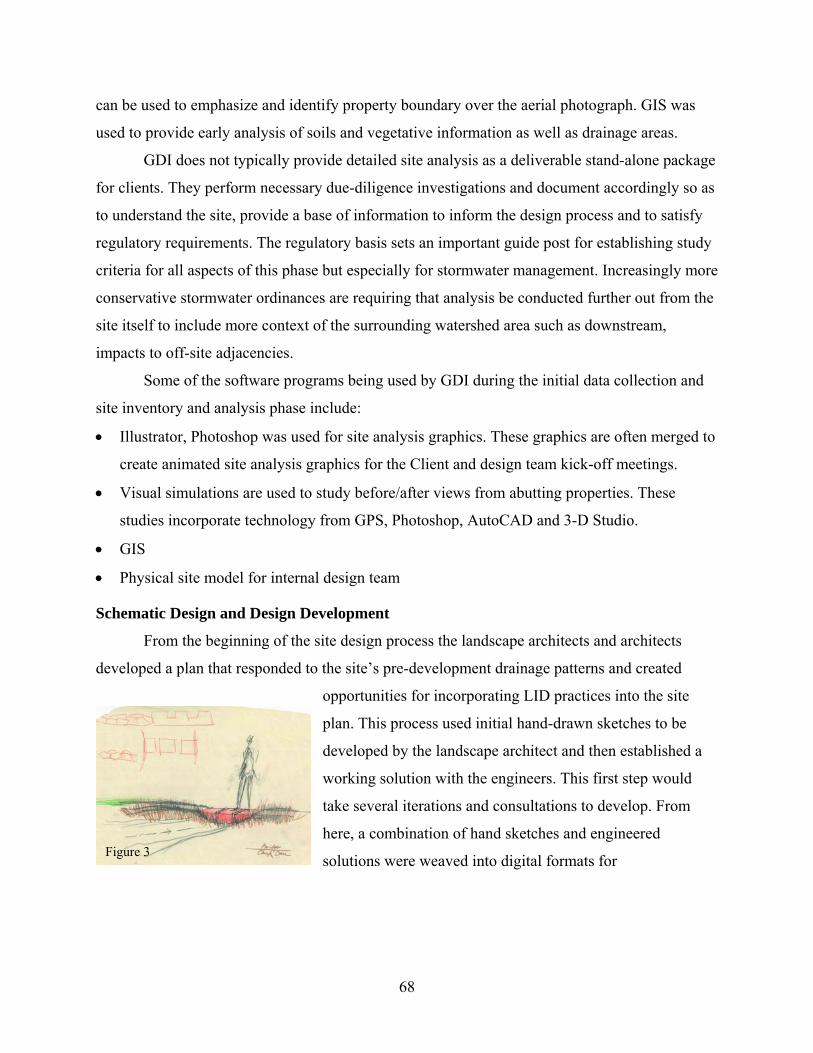
can be used to emphasize and identify property boundary over the aerial photograph. GIS was
used to provide early analysis of soils and vegetative information as well as drainage areas.
GDI does not typically provide detailed site analysis as a deliverable stand-alone package
for clients. They perform necessary due-diligence investigations and document accordingly so as
to understand the site, provide a base of information to inform the design process and to satisfy
regulatory requirements. The regulatory basis sets an important guide post for establishing study
criteria for all aspects of this phase but especially for stormwater management. Increasingly more
conservative stormwater ordinances are requiring that analysis be conducted further out from the
site itself to include more context of the surrounding watershed area such as downstream,
impacts to off-site adjacencies.
Some of the software programs being used by GDI during the initial data collection and
site inventory and analysis phase include:
• Illustrator, Photoshop was used for site analysis graphics. These graphics are often merged to
create animated site analysis graphics for the Client and design team kick-off meetings.
• Visual simulations are used to study before/after views from abutting properties. These
studies incorporate technology from GPS, Photoshop, AutoCAD and 3-D Studio.
• GIS
• Physical site model for internal design team
Schematic Design and Design Development
From the beginning of the site design process the landscape architects and architects
developed a plan that responded to the site’s pre-development drainage patterns and created
opportunities for incorporating LID practices into the site
plan. This process used initial hand-drawn sketches to be
developed by the landscape architect and then established a
working solution with the engineers. This first step would
take several iterations and consultations to develop. From
here, a combination of hand sketches and engineered
solutions were weaved into digital formats for Figure 3
68
communication with the architects and clients (see figure 3). Most design efforts for this project
began as hand sketches in plan or section (see figure 3). These studies are then typically
transferred to the computer via AutoCAD and are then incorporated into the following:
• Physical site models are created to test earth forms, planting concepts, and massing
relationships.
• Photoshop for plan renderings or image edit studies of before/after photo montages.
• 3-D Studio is utilized for wire frame studies to sketch over, or development of particular
views for design team reviews and client presentations. Solar studies are often prepared for
more intimate spaces such as courtyards.
• HydroCAD, LDD and other civil programs are used to analyze drainage and earthwork
(cut/fill) throughout the design process.
• Microsoft PowerPoint is a key component for visual presentations to the Town and Client
(see Figure 4)
69

Permeable Pavement and Fire Lanes
Figure 4
Stormwater Strategies
From the beginning of the design process stormwater strategies were integrated with the
development of the site plan. The landscape architect lead the way with design ideas for creating
opportunities for surface detention of stormwater in ways that will help protect lands from
flooding, be environmentally sound, and create interesting landscapes for living (see discussion
under Project Background above). The town of Dedham is very restrictive in its stormwater
regulations — more so than MASS DEP — as they require all stormwater generated to remain
on site. To reduce the need for large detention basins the designers sought to create a series of
smaller basins and looked for opportunities to provide infiltration where possible and allowed.
Ideas were sketched and “walked over” to the engineers. Typically compromises were met that
settled somewhere in the middle of two extremes. The end result being the plan currently before
70

the town for approval includes a series of stormwater strategies that will help to slow down,
filter, hold and infiltrate storm flows.
• Rainwater harvesting: Stormwater from all the roofs will be harvested and collected in
cisterns to be used for landscape irrigation. While this accounts for a large percentage of
discharge from impervious surfaces (roof) that is being generated it was not counted in the
discharge calculations. Overflow will be diverted to the detention system when full. When
cisterns are empty and no water is available for irrigation well water will be used.
• Grassed or vegetated swales: Bioswales and vegetated swales will be used as a means of
conveyance. They are being used to slow and attenuate peak flows to increase the time of
concentration within the sub-catchments. Regulations require 80% removal of total
suspended solids (TSS) before infiltration occurs. Therefore, swales, catch basin deep sumps,
sediment basins, and maintenance such as sweeping all function the same way to remove
harmful sediments before discharge to surface or ground waters.
• Groundwater recharge of stormwater via infiltration basins: Detention basins were designed
above and below grade. Below grade basins compose approximately 80% of the total
detention. They consist of 24 to 48 inch diameter perforated pipes that will store and
infiltrate.
71

Figure 5
72

Permitting Agencies
The site is subject to the jurisdiction of several overlapping federal, state and local regulations
that regulate water and water quality:
• Federal Clean Water Act [33 U.S.C. 1251, et seq.].
• Massachusetts Wetlands Protection Act [M.G.L. c. 131, § 40] (MWPA).
• MWPA implementing regulations (310 CMR 10.00).
• Town of Dedham General Wetland Protection Bylaw (Bylaw, revised April 2002).
• Dedham Conservation Commission Rules and Regulations (Rules, revised May 23, 2002).
The project’s complex regulated areas were field located and documented by ENSR International
and then surveyed for delineation (see Figure 6 and Table 1).
Figure 6
73

TABLE 1a The following three pages demonstrate the sheer quantity and high level complexity of the permit process that is required for this project.
74

TABLE 1b
75

TABLE 1c
76

Figure 7
CONCLUSION
Design Process and Technologies
The design process stands out as a statement to the need for complete integration of digital and
hand design techniques, collaboration between consultants, and conventional and innovative
water conservation practices. This is a firm that works extra hard at developing new applications
for digital technology and integration into design. First, they rely heavily on hand-drawn
graphics to explore design ideas, especially initially. These sketches are step-one in a process at
GDI of exploring and communicating thoughts for conceptualization. This allows testing,
refining and collaborating quickly before it is input digitally. This works as an educational and
exploratory tool to express a designer’s idea to other team members before they are introduced as
viable solutions to other consultants out-of-house or to the client. In the case of stormwater
77

management design, hand sketches were used to begin a dialogue between the landscape
architects and engineers to explore how these alternative practices can be made to fit with the
overall drainage patterns and the need to control discharge and water quality on site.
Stormwater Design
The integration of stormwater management practices is seen in this project as an
adaptation of conventional methods and innovative practices and is due in large part to the
interest and persistence of the landscape architect. The marriage of relatively new and more
stringent regulations and guidelines with tried-and-true methods for calculating discharge
volumes require hand-crafted and innovative approaches to meet expectations yet incorporate the
new methods. For example, this project has over-designed capacity in its detention areas to allow
for potential overflows from cisterns that collect roof water. Interpreting my discussions with
GDI personnel leads me to assume that such innovations as roof water harvesting could remove
substantial quantity of stormwater from volume calculations yet the permitting agencies did not
allow this for this design. Also, the question can be extended to such devices as vegetated and
bioswales. Therefore the question becomes can these systems be used to not just conserve water
or slow and attenuate peak flows but how can they be used for water quality enhancement,
storage volume and recharge? For example, can open channel volumes and subsurface soil
volumes be used to calculate detention storage as well thereby allowing reduction of surface
detention basins and increase land area available for more surface treatment practices and allow
full use of property?
78

4.3 Case Study Three:
Conservation Design Forum: Tellabs Headquarters
Firm Profile
Description of Firm See Case Study Two above for firm information.
Project Case Study
Project Information Project Name: Tellabs Corporate Headquarters
Location: One Tellabs Center, 1415 West Diehl Road, Naperville, IL 60563.
Client: Tellabs Corporation, Inc.
Site Area: 55 acres
Landscape Development Costs: $2 million (A:T1)
Design Team: Architect: TMI Affinity, Corp., Arlington Heights, IL
Engineer: National Survey and Engineering, Brookfield, WI (NSE)
Landscape Architect: Conservation Design Forum, Elmhurst, IL (CDF)
General Contractor: Pepper Construction, Barrington, IL
Project Schedule: CDF Contracted: November 1999
Permits: Early 2000
Construction Documents: June 2000
Construction: April to August 2001
Building Gross Floor Area: 850,000 +/- Square Feet
Building Footprint: 187,000 Square Feet / 4.3 Acres (7.8% of total site area)
Structured Parking Footprint: 113,000 each for a total of 226,000 Square Feet / 5.2 Acres (9.5% of total site area)
Parking and Drives: 623,000 Square Feet / 14.3 Acres (26% of total site area)
Landscaped/Open Areas: 1.360,000 Square feet / 31.2 acres (56.7% of total site area)
Off Street Parking:
79

Structured: 1800 + 14 accessible spaces = 1814
Surface: 740 + 24 accessible spaces = 764
Total: 2578
Introduction
The Tellabs HQ in Naperville provides an interesting study of conventional design versus
conservation design. In the short history of a new direction for stormwater management and
design, this project registers relatively early in the timeline. This is true for the field of
stormwater design in general as well as the development of environmentally sensitive drainage
design at CDF. Since this project CDF has become one of a few around the US that have become
a leader in this area. Firm representatives are often quoted in LAM for new techniques and
practices. During interviews for this case study and MRV discussed earlier, the office
acknowledges that this project played a large part in the learning curve for using innovative
stormwater technologies.
The first impression of the Tellabs site on Diehl Road in Naperville appears to be that of
a typical landscape typology: the suburban corporate campus. The landscape along the I-88
corridor is typical of corporate suburbia: large lot commercial developments that serve as high-
tech headquarters for some of the world’s largest corporations. An initial glimpse of the facility
from Interstate 88 may not reveal an immediate perceivable differentiation from adjacent uses.
This initial reaction may be attributed to intense distractions from traffic congestion and speed
approaching the site. Upon closer examination, the differences become clearer and in fact are in
shear contrast to the neighbors.
80

Figure 1
What is most helpful to appreciating the differences between this campus and that of its
neighbors is the clear and simple organization of the site. It is characterized by easy to
understand geometry which leads a visitor logically to the desired destination. The strong
building symmetry is extended out into the landscape and provides immediate perception and
understanding of the site. The centerline of the building entrance is coincident with the wide
boulevard entry drive. A visitor is able to relax from the need to make sense of arriving and to
begin to comprehend the characteristics that make this landscape unique. One of the first features
that can be appreciated is the generously wide central landscaped area of the boulevard (see
figure 1).
After first entering the driveway from Diehl Road the boulevard widens from 10’ at the
apron to 55’ wide through graceful horizontal curves that transition from the north/north-east
orientation of Diehl Road to the north-south orientation of the site geometry. The narrow throat
at the apron also assists in the comprehension of arrival—in and out within safe sight distance of
each other—and this eventual expanse provides a complimenting scale relationship to the
81

structures and ample room for an impressive landscaped feature of water, stone and native plants.
Figure 2
The built environment is brought out to the edge of both ponds with two paved gathering areas /
viewing platforms overlooking waterfalls (see figure 2). The source of this water feature sits at
the end (north) of the boulevard near the building entrance and motor court/drop-off circle. It is
here at the terminus of the boulevard where an arrangement of stone and a water cascade
provides the source of the water channel meandering from the north to the south along the
82
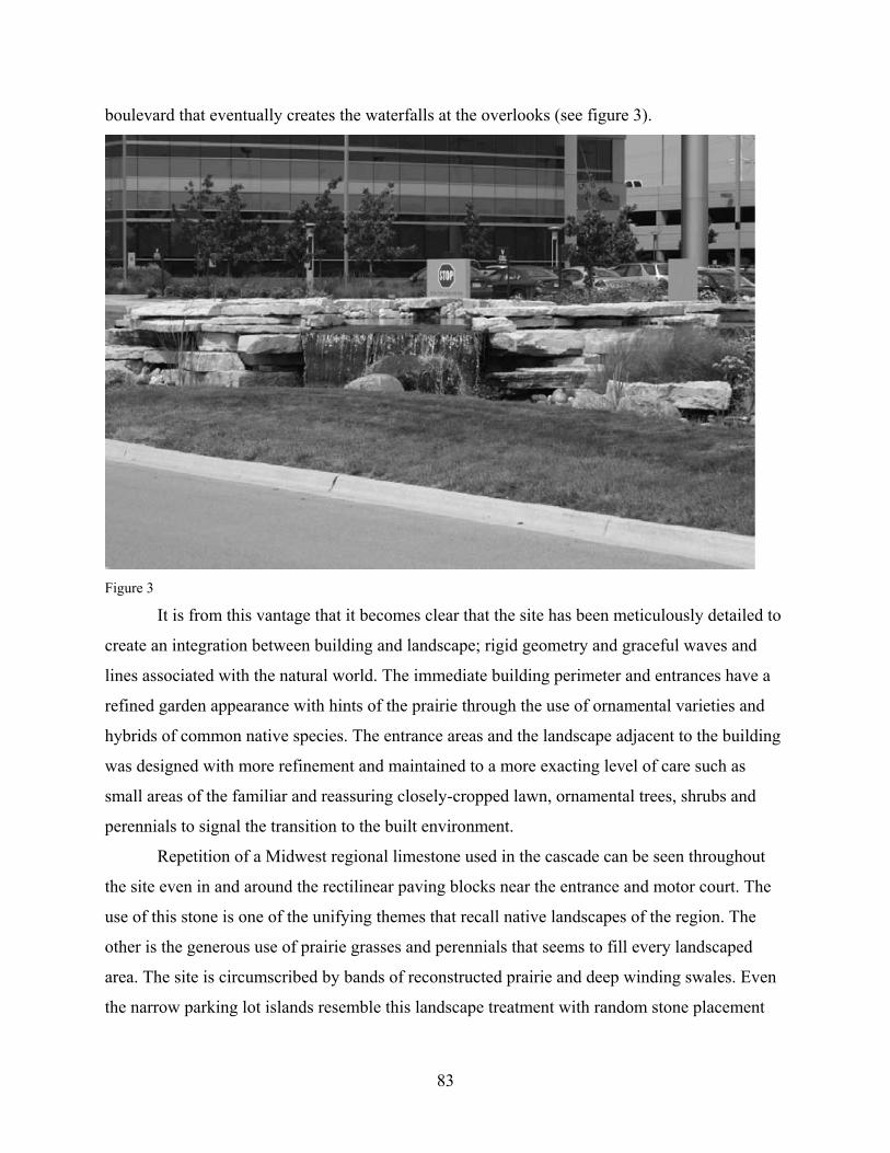
boulevard that eventually creates the waterfalls at the overlooks (see figure 3).
Figure 3
It is from this vantage that it becomes clear that the site has been meticulously detailed to
create an integration between building and landscape; rigid geometry and graceful waves and
lines associated with the natural world. The immediate building perimeter and entrances have a
refined garden appearance with hints of the prairie through the use of ornamental varieties and
hybrids of common native species. The entrance areas and the landscape adjacent to the building
was designed with more refinement and maintained to a more exacting level of care such as
small areas of the familiar and reassuring closely-cropped lawn, ornamental trees, shrubs and
perennials to signal the transition to the built environment.
Repetition of a Midwest regional limestone used in the cascade can be seen throughout
the site even in and around the rectilinear paving blocks near the entrance and motor court. The
use of this stone is one of the unifying themes that recall native landscapes of the region. The
other is the generous use of prairie grasses and perennials that seems to fill every landscaped
area. The site is circumscribed by bands of reconstructed prairie and deep winding swales. Even
the narrow parking lot islands resemble this landscape treatment with random stone placement
83

and native sedges within shallow depressions that extend the entire length of twenty-six parking
stalls (see figure 4). From the waves of grasses, perennials, the patterns of the paving blocks at
the entrance; to the repetition of the rugged and blocky natural stone; to the glimpses of the
prairie grasses and vegetated swales; to the open water of the ponds; and finally to the central
water cascade and channels leading to the dual water falls at each pond. These elements have
been designed to present an understanding that there is a connection between them.
Figure 4
Pre-Development Conditions
The 55 acre site is bounded on the north by the I-88 corridor, on the east by Raymond
Drive, and on the south by Diehl Road. The western edge is adjacent to a conventional corporate
office complex. Across Diehl Road to the south is a stream corridor which flows east into the
West Branch DuPage River which is partially protected by the McDowell Grove Forest Preserve;
a 426 acre recreation area across Raymond Drive to the east.
According to the narrative from the wetlands submittal to the City of Naperville prepared
by CDF, the original site condition was characterized by gently sloping land from north to south.
84

An area along the northern boundary was comprised of deciduous and conifer trees nursery stock
for future use by the previous land owner. Besides a small strip of grass, the balance of the site
was agricultural land. In the southern portion of the site, within the area of cultivation, were two
small isolated wetland areas that provide zero stormwater storage capacity for the drainage areas
served.
Background and Role of Landscape Architect
CDF became involved in the project because of an existing relationship with Tellabs for
work at their Bolingbrook and Lisle campuses. At the Bolingbrook site, CDF created a prairie
landscape that has been in place since about 1996. Initially the prairie aesthetic and
appropriateness was questioned by users as well as city officials. This was especially true during
the annual burning maintenance procedure. Neighbors were contacted and educational sessions
were conducted. The fire department initially provided full coverage; however after a couple of
years of properly conducted prescribed burns, their concern for safety subsided and their
attendance stopped all together. Annual burning of prairie landscapes can be a fascinating and
even celebratory event for the public (see figure 5).
Despite Tellabs interest in the native prairie landscape restoration at the Bolingbrook
campus, active stormwater infiltration measures were not included here. It was not until CDF
became involved with the Naperville project that innovative stormwater infiltration methods
become a primary focus of the proposal. In
fact, CDF was not part of the initial design
team. The project was first advertised by
Tellabs as a design-build competition.
Following selection of the team the site
plan was developed. At this stage of site
plan development surface parking
dominated the landscape and conventional
stormwater practices were planned.
It was in the fall of 1999 when
CDF was first asked to review the proposed plan to suggest strategies for implementing prairie
areas as they did for the other Tellabs facilities. They immediately suggested making some
Figure 5
85

adjustments to the site plan. These included pushing the building away from Diehl Road and
toward I-88 and incorporating structured parking. This would accomplish a couple of goals
besides the initial charge of creating native landscaped areas. It would provide the large office
building with a grander entrance from Diehl Road, a relationship more in scale with the building
and the two parking structures. Another benefit of this would be to create a more obvious
presence on I-88, known as the tech-corridor. These revisions were developed quickly into a
final site plan in order to meet with city officials and attain plan approval. Simultaneously with
City and County review, construction documents were being developed and issued in June of
2000. Construction activities commenced in April 2001 and were completed by the end of
August of the same year (see figure 6).
Figure 6
86

Besides the initial site plan revisions, the scope of services for CDF included the design and
function of the bio-swales and basins, wetland mitigation, special pavement areas around
building entrances and the outdoor eating area, special landscape features such as the central
water cascade, channel and waterfalls/overlooks, walking paths, and all the prairie development,
plantings and soil amendments.
Design Goals and Principles
The main purpose of the site plan revision as proposed by CDF would be to provide
sufficient open space in the front yard and around the periphery for native prairie landscaped
areas to align with the other Tellabs facilities. For CDF, the installation of prairie was an
opportunity to reduce the energy-intensive use of Kentucky bluegrass lawn. The restored native
landscape can provide a multitude of intangible benefits from increased biodiversity, better soil
structure to a hydrologic regime that more closely resembles pre-settlement patterns. On
uncompacted soils, native prairie landscape encourages the natural hydrologic patterns afforded
by the deep rooted native species. Economically speaking, Tellabs has found favor with native
landscaping after tracking maintenance costs from other facilities which showed fifty percent
savings on annual maintenance costs. However, as previously mentioned, the areas closest to the
building perimeter were designed as a more carefully tended garden with ornamental plants and
small areas of mown lawn in contrast to the native plant associations of the open spaces beyond.
The site plan revision also allowed the potential for people to enjoy the outdoors. The result is
an aesthetically interesting and changing landscape that is enjoyed from a car or from inside the
building as well as opportunities for closer contact via walking paths.
However, this opened other design opportunities for CDF as well. Once the open space
was in place it allowed the prime overriding design principle to become manifest. According to
Jay Womack — the project landscape architect — this was to avoid any direct discharge of
stormwater into the detention basins. The native prairie created a framework for pre-settlement
water patterns by retaining the ambient rain that falls within this particular landscape. However,
even with as much as thirteen acres of prairie open space retained, the site plan still imposed
almost twenty-four acres of impervious surface over what was once open agricultural land.
Therefore further measures were necessary to ensure that water leaving the site was reduced to a
minimum as required and that water quality could be controlled. To do this a series of best
87

management practices were proposed to decentralize stormwater management. These included 1)
open and shallow bio-swales in the parking areas, 2) large perimeter bio-swales planted with
native perennials and grasses, and 3) level spreaders. The bio-swales in the parking areas were
designed to accept the first flush of precipitation — the first half inch or so which contains the
bulk of toxins from the adjacent parking — to slowly infiltrate into the soil and thus eliminate
direct discharge into the ponds.
Additional design goals set forth by CDF during the redesign are common mantras for
landscape architects: disturb less area and conserve existing features, soil, and trees whenever
possible. With this in mind, CDF preserved a small hill in the northwest corner of the property,
which in turn saved a number of large trees, providing significant cost savings. It also supports
the previously mentioned goal of providing opportunities around the site for outdoor
experiences. Atop the small preserved hill, a belvedere, or overlook, was designed to take
advantage of extended views of the surrounding area (see figures 7).
This spot has become an especially
popular destination at lunchtime.
Additionally, about 60 trees that were k
at the site prior to development as nurse
stock were saved and relocated to the
overlook area and along the western
boundary providing a randomly placed
grove for a discontinuous buffer to the
adjacent property.
ept
ry
Figure 7
Stormwater Strategies
As previously mentioned, the site plan was designed with the primary goal of reducing
direct discharge into the detention ponds. The building’s strong symmetrical organization seems
to influence the drainage patterns as well. The entry drive, main entrance and parking are
symmetrically located around the center axis of the building. This provides a clear site
organization that allows easy to understand way-finding. This structure also divides the site into
88

two distinct drainage areas. The central axis became the central drainage divide of the site,
directing water from the roofs, the parking structure and the site to the west and to the east into
large, open swales with native plants.
Each parking bay drains into a bio-swale
that collects overland flow from the
parking surfaces and provides infiltration
and reduced flow rates over the gentle
gradients of the swales. During larger
storm events, when the bio-swales reach
their infiltration capacity, water flows
into pipes which are connected to larger
overland bio-swales where rain travels an additional 1000 to 2000 feet before entering the ponds.
Figure 8
The stormwater design as prepared by NSE used TR-55 to analyze the existing and
proposed runoff generated as well as the curve numbers and time of concentration. They also
used the SWMM model to determine hydrographs for a 6 hour storm event to meet the DuPage
County regulations instead of the 24 hour events typically required and that TR-55 uses. They
also used the Haested Method Flow Master program to determine emergency overflow weir
criteria. However, the detention basins that flank the entrance drive were sized based on peak
flows as required by the county. The high water elevation was determined for the 100 year storm
and assumed direct conveyance into the ponds. The open channels or the subsurface soil voids of
the swales were not used to consider offsetting storage requirements of the basins or the time of
concentration for the drainage areas.
The eventual destination for stormwater is the two detention ponds located on each side
of the entry drive (see figure 8). They are designed with a normal water elevation that is equal to
ground water. The edges of the basins are graded to provide a bench around the periphery that
slopes gently into the pond. The slope is graded at roughly 20:1 at the water line and dropping to
6” below normal water level (NWL). The shelf then drops at 10:1 to about 18” below NWL, and
then drops sharply to a depth of about 5.5’ (east pond) and 6.5’ (west pond). The benches are
intended to provide habitat for wetland plants, such as emergent, sub-emergent and floating
aquatics in the shallow water.
89

CDF made a conscious choice to not plant the edges so as to observe the actual pond
water levels for one year following completion. Therefore, the area was allowed to
spontaneously establish. Subsequently, within approximately two months, the pond edges
became vegetated with soft stemmed bulrush, eleocharis, water plantain, and arrowhead, among
others. CDF believes that this favorable result is due to the elimination of direct discharge into
the ponds; moving stormwater first through the open bio-swales. Another benefit of the prairie
landscape around the ponds is elimination of continual mowing to the waters edge. This has
greatly reduced the habitat that attracts geese thus further reduction of nutrient loading (see
figure 8).
Awards and Recognition
According to Brook McDonald, executive director of the Conservation Foundation, what
makes the new Tellabs campus different from most other corporate and business environmental
efforts is the emphasis on innovative stormwater design. He was quoted to say that the
stormwater system “virtually eliminates runoff and resulting pollution from oils and
contaminants commonly found in parking lots” (Van Matre, 2002). The Conservation
Foundation is a not-for-profit land and watershed protection organization in Naperville and
manages the McDowell Grove Forest Preserve across the street. Its mission is “to enhance the
quality of life by preserving open space, protecting natural lands, and improving rivers and
watersheds” (The Conservation Foundation, Accessed 2004). It awarded Tellabs the Brooks
McCormick Environmental Award in 2002 for its commitment to environmental responsibility.
Conclusion and Discussion
Collaboration
A designed landscape is influenced by virtually every element, discipline or trade during
design and construction. Therefore, successful landscape development depends on collaboration
and cooperation. Ideally this effort should be based on clearly established and agreed upon
values, goals and objectives. This is not always possible and often a rare occasion when it does
happen. This goal-oriented collaboration should begin during the early stages of design. Given
the increased complexities of project implementation it is very important, especially when
considering such innovations as represented in this project to have continuous dialogue with all
90

consultants. Technologies that are not part of conventional design and building practices require
open-minded attitudes and clear communication to be successful.
The contractual structure of this project created a challenge in this respect. One example
is the earthwork and grading of the land. CDF was active in making grading recommendations
and suggestions as to bio-swale and basin design; however, their scope was limited with regard
to this facet. As a result some finer details may not have carried through from conceptual intent
to final design and built work. This can prove to be a challenge to execute seemingly subtle
design requirements when consultants and other team members are not as committed to an issue.
Lessons Learned
In time, new landscape technologies, such as the best management practices used on this
project, along with other sustainable technologies will change from innovation to conventional
practice. The design field and construction industry will develop new methods and better
materials for these applications. Part of the process of expanding and changing is studying past
works for their successes and failures. Post-construction evaluations have historically been
considered as critical to expanding knowledge and treated by most as part of the design process
continuum. However, most practitioners are not allowed to follow this advice due to contractual
limitations. Sharing of information through writings and documented case studies is an excellent
way to bring issues up for scrutiny. In this way gaps between professional segments might be
spanned.
Through the process of design, collaboration and construction on this project CDF has
acquired valuable experience and knowledge. They have adopted the stance that research, post-
construction evaluations, and writing about their philosophy not only helps their own purpose
through education and exposure but also advances the professions associated with land
development and society in general.
Through the construction of this project and experience elsewhere, CDF arrived at a
preferred refinement to the parking lot bio-swales and associated curb detail. The original design
called for 2’-0” wide cuts in the parking lot’s concrete curb allowing drainage to pass into the
bio-swales from the pavement. Each spillway, at roughly 30’ intervals, included randomly placed
91
“washed river stone” in a flume about 3’-0” long by 1’-6” wide (see figure 9).
Figure 9
The spillway spacing, however, limited where water can get into each swale. A possible alternate
to this design would be to eliminate curbs along the uphill side and include a continuous ribbon
of stone adjacent to the edge of pavement or increase the spillways to every third car stall. This
would help reduce the energy of the water entering and give it a chance to be more evenly
distributed across the bio-swale.
Directions
Tellabs-Naperville is an example of stormwater management integrated with design and
opens the possibility to build towards more sustainable building practices. First, post-occupancy
evaluations, surveys, and testing should be included as a component of the project. A prime
example would be water quality testing to understand how bio-swales can provide this benefit.
With proper planning a study of construction costs could also be conducted to better compare
conservation versus conventional practices. Second, communication is an important part of any
design and construction project. Design strategies and maintenance requirements for innovative
92
ideas must be clearly communicated so that decisions are not made in a vacuum without
knowledge of their implications. Goal setting and definitions should be established early with all
team members committed to them.
Technology
Developing new technologies and changing long-held traditions and design methods in
the construction and landscape industry will not be easy. With regard to landscape technologies
and stormwater design, the benefits that can be achieved are not only worth it but necessary.
Design technology that is used for stormwater management relies on programs that have been in
use for a long time in a prescribed manner. This project is an example of how rapidly technology
is changing. It was only just designed and documented in 1999; however, the tools and methods
of design have already evolved since then. The stormwater and flood control aspects of the
project had to meet existing regulations and techniques for calculating flows however new
landscape technologies were being introduced that could potentially alter those methods. From
the landscape architect’s perspective, the project was designed and documented in a very
traditional and low-tech method. Ideas were generated form hand sketches at the SD level and
these hand sketches were then developed into CDs for construction. CDF produced very little
computer generated drawings for this project. Secondly, from an engineering perspective the
storm drainage calculations focused on end-of-pipe solutions (detention basin and conveyance
technology) versus incorporating infiltration and storage in a completely integrated and
decentralized manner. Perhaps these technologies can be adapted in new ways so that open
channel design can be calculated for increased time of concentration and reduced imperviousness
and allow for infiltration to effectively allow for reduction in peak flow control requirements and
therefore make detention basins smaller.
Finally, despite some of the difficulties and embryonic nature of the process and results
of Tellabs-Naperville, it seems clear that this project demonstrates that site design can work
systems that mimic natural hydrologic processes to mitigate the intensity of storm events and the
damage caused by human built landscapes and activities on a site level basis. Other less tangible
benefits such as connection of people to the landscape are exemplified here. This can be seen
through seasonal events like prairie burns or through use of trails and a new awareness of the
way water moves through the site can change personal perspectives. Ultimately societal attitudes
93

may shift so conservation and preservation and more sustainable methods of living can be
possible.
4.4 Case Study Summary
The three case studies represented range in size and purpose; however all strive to design
with water in ways that will minimize the effects of new impervious surfaces by using innovative
stormwater design strategies. One is a small site scale corporate suburban development (55
acres) outside of Chicago that has been built and in use since 2001. Another is a larger scale
community site design of 162 acres that is located in Dedham, MA and is currently in the design
development and permitting phase and scheduled to be built in 2009. The third is a regional scale
planning study that was completed in 2003 but will be implemented by way of county by-laws
and a long education process and therefore will be designed and built over time essentially by
others. Each of these projects has utilized innovative BMPs that have been called integrated
management practices (IMPs) because of the holistic approach to site design that it requires
(PCGDER 2000). Other publications have termed the use of these practices as stormwater
treatment practices because the technology tends toward the treatment of water quality versus
quantity (CTDEP 2004).
The purpose of these practices is to mitigate the breadth of impacts caused by
urbanization on watershed health from volume and velocity to pollutants, suspended solids and
temperature. Implementation of these practices has not been readily adopted by all involved in
development as yet. The three projects discussed here exhibit the problem of integrating new
ideas and methods in a process of drainage design which is well established. The attempt to plan
and design using these practices has not been embraced thus far by all those responsible for
development. The full assimilation of theses practices into the process of design will take time to
sort them out and work with them for a while. These projects demonstrate some of the
difficulties and progress in accepting new technologies and how they correspond to an existing
system of design, construction, and permitting. All phases of design, from conception and
detailing to permitting and implementation meet these changes to the landscape and the design
process resistance and challenges from a status quo.
94

In 2000 USEPA issued the Final Rule of the so-called “Phase II” of the NPDES which
extended existing law for certain municipalities to implement and control the affects of
stormwater on receiving water bodies. States have been responding these new rules with mixed
efforts and along dissimilar timelines. The Connecticut DEP has issued their General Permit that
addresses the concerns within Phase II in 2004 along with a comprehensive manual for guiding
development and implementation of stormwater treatment practices. Projects before this time
such as Tellabs-Naperville were slightly ahead of the permitting curve and were trying these
methods out from a design, functionality, construction, and aesthetic perspective but also with
regard to permitting mechanics. Simply many have not had direct experience with these
landscape treatments and therefore many questions arise. Questions about cost, effectiveness,
aesthetics, flood control, among many others.
The landscape portion of the Tellabs project (Case Study Three) was conceived and
documented in a very traditional, hand-crafted and low-technology approach. The landscape
architect used primarily hand graphics to design and communicate the stormwater component of
the project. The plan strove to reduce concrete pipe, keep rain water exposed as much as possible
and slow the velocities. To do this the plan called for open swales in the parking lot and large
prairie bioswales around the perimeter collect all the water from the site before entering the
detention ponds thereby allowing native vegetation to absorb, transpire, encourage infiltration
and filter pollutants prior to entering the ponds open water. This simple goal earned the project
an award from the local environmental preservation group for the effort. However, in order to
work with the structure of the local permitting agencies the peak flows used to design the DB
were not attenuated for consideration of the storage, time of concentration and possible
infiltration afforded by thousands of feet of open grassed channels. According to Tom Price of
CDF, there is opportunity to make use of storage volumes within open channels and even in the
soil structure that can hold about 40% of its volume.
Case Study One, known as the Senior Community Campus project (SCC) met similar
issues with permitting agencies. From the beginning of the project, the designers sought to
incorporate low-impact development practices into the project as recommended by the Prince
George’s County, Maryland National Guidelines Manual. While the town of Dedham has
extremely aggressive and progressive stormwater regulations that are responding to the new
95
phase II rule many of the practices that the landscape architect wanted to utilize had to meet the
town’ regulation. Dedham requires water quality treatment practices especially in the
environmentally sensitive area near the Charles River where the project is located. However,
many of the ideas had to be negotiated and massaged to make work within the town’s
expectations. As with the Tellabs project, SCC could not use the open swales on the project as
infiltration because of water quality concerns nor could they be counted toward volume
reduction for peak flows. Consistent with this more recent project is the need for a person, firm
or agency to provide inspiration and motivation to create opportunities to try these relatively new
practices. In each case the landscape architect generated hand sketches to promote and
communicate ideas of low-impact development and stormwater treatment practices that normally
may have been handled by conventional end-of-pipe solutions.
The more regional scale planning study at Blackberry Creek (Case Study Two) also by
CDF, demonstrates how planning agencies are recognizing the need for watershed scale planning
to understand the impacts of development but also that the impacts occur on a site scale and on a
site by site basis. The statement that to achieve better stormwater treatment designs should keep
water as close to its source where it falls as possible indicates how important site design is.
Therefore this study used site scale modules of possible development scenarios that used these
stormwater BMPs to understand not just how water might move on the landscape and therefore
how to model it and what effect it might have but also to generate visual icons for what the
landscape might look like. CDF used continuous simulation computer modeling (SWMM) to
understand how a build-out in the watershed of both conventional, by-the-book development and
conservation-minded, low-impact development would act and the resulting impact on water
quality and quantity. When considering design process and promoting new ideas, the interesting
aspect to this study lies in the fact that these templates were designed and drawn by hand. Hand
drawings can have the effect of expressing human scale, texture, and perception to a flat 2d
image. Since public perception and education is a major component of this project, the
expression of the designer’s hand helps people to perceive what this landscape might look like
while simultaneously provide data for analysis.
96
CHAPTER 5: CONCLUSION and DISCUSSION
There is a movement occurring that is suggesting that the design profession needs to
reconsider the conventional methods of stormwater design. It is rooted in the notion of ecological
and hydrological function and health and is associated with green building and sustainable
design principles. The idea that the health of urban streams and the aquatic life within is directly
related to the way the land is built on. The more imperviousness of a watershed the greater is the
stream degradation. Designers, especially landscape architects, wanting to protect habitats and
provide green space for living have been working with this idea for decades but it is only now
that awareness is becoming part of the lexicon of all involved in design on the land albeit still in
its infancy and on the fringe.
A few forces are helping to expand change in this area such as the sustainable movement
and scientific understanding of ecology and hydrology. Because of this pressure governmental
agencies from the USEPA to local towns are becoming aware of the need to protect valuable
water resources and the relationship to the human condition. New USEPA regulations have
required adoption of more inclusive regulations that control stormwater runoff. Some
communities such as the State of Connecticut with its 2004 Stormwater Quality Manual and the
town of Dedham, Massachusetts with its strict permit process — as shown in the case study for
the Senior Campus Community — have taken it a step further to advocate for innovative
technologies over conventional. Despite this raised awareness within the landscape architecture
profession and the growing trend there is need for change and acceptance before these alternative
techniques become main stream.
Low Impact Development has become a standard that is being followed across the
country thanks to the work of the Department of Environmental Resources, Programs and
Planning Division of Prince George’s County Maryland and the publication of their manual in
2000. The contents of the LID approach began in the 1980s and through a process of testing and
review and through implementation in and around the Chesapeake basin positive results have
become visible. Many firms, states and towns are using this as the starting point for adapting
their own guidelines. For example, Connecticut’s new manual is based on the LID approach.
Additionally some firms are using it as a framework to structure a project proposal in order to
97

sell the client and consultants on the idea. This was seen in the case study for Senior Campus
Community by Geller-Devallis where LID was a goal that was established early on in the
process. Also some engineers are basing new design software on this approach. For instance new
tools developed by T.E.Scott and Associates will help engineers design for infiltration and other
LID methods (see Chapter 2).
From these separate pieces it can be safely concluded that LID and similar conservation
practices that focus on non-structural, open-flow, infiltration and biologically based storage and
treatment are developing in stature and recognition and acceptance. There is still much work to
be done by designers and researchers to try these practices out on projects, educate the public
through presentations and built projects and convincing regulatory agencies to allow as much of
these so-called BMPs (LID approach recommends the term Integrated Management Pracices or
IMP) in a given site design as possible.
The implementation of LID IMPs into the design tool box of ideas and technologies will
need more work to become accepted. Many who are not convinced that change is necessary
worry about effectiveness and budgetary realities of a project under strict commitments and
constraints. Also of concern is how the technologies translate across climatic zones. These
important concerns reflect the true realty of site design and the sensitivity with which all need to
approach this topic. First, no two sites are the same and each should be evaluated individually for
soil, hydrologic patterns, land use, contextual issues and public questions. Therefore a cookie
cutter approach is not advisable.
Additionally, proper implementation of LID and similar design ideas require a team that
is more complex than ever before. One discipline can not handle this on its own. The master
architect is possibly moving into obscurity. It is true that a project team needs to be lead by those
who understand all the issues and can talk to all the disciplines to synthesize a design for human
use that works. But it is also true that other disciplines must be included earlier on in the process.
The rising complexity of our knowledge of environmental systems and the way in which human
developments are interacting with the non-human processes need the knowledge base of many
professions. This can be seen in the Senior Campus Community project. The landscape architect
effectively lead the team to understand what is possible but engineers, architects, as well as
98

environmental specialists were needed to understand how to design the open spaces adjacent to
the river. The right questions need to be asked early in the process. This requires a diverse team
that can address issues others do not see.
As Crittenden et al suggested a metadiscipline will be required to begin to make sense
and engineer and sell the ideas of sustainable development (Crittenden, Mihelcic et al. 2003).
Certainly, today, experienced project managers and designers are familiar with the team concept
of project development and one might suggest multi-disciplinary teams are currently part of the
process. However, experience shows that most project development teams are composed of the
basic disciplines such as architects, engineers and sometimes landscapes architects. What is
suggested here is that teams need to be more inclusive earlier in the process and also expand to
include other disciplines and specialties that can understand and analyze the ecology and natural
processes.
With regard to stormwater design specifically, the early stages of the project should
include members who understand the constraints and the possibilities. Too often, a project
principal will ask a designer to include site related “green” or sustainable building practices
when it is too late to add elements such as swales and infiltration basins into a the scope. This
becomes especially important when a goal is to integrate these elements with natural processes.
Other disciplines, such as hydrologists and restoration ecologists, become critical to ask the right
questions and develop the right plan of action.
To properly assimilate a project team and develop a scope that reflects these goals project
principals need to understand these issues. One profession will need to take charge and begin to
help to coax and implement these new ideas into our standard lexicon. As we have seen from the
case studies, landscape architects seem to be playing that role in all three cases. When
considering site design issues landscape architects may be best suited for organizing the
complexities of a project. All disciplines cross under, through, over and touch on the landscape
and therefore the profession best suited to interpret those many needs and artifacts and consider
the aesthetic and cultural implications is the landscape architect. The collaboration process will
continue to evolve and the need for that one discipline to emerge as a leader will help provide a
singular vision.
99

Engineers are critical to this work and will need to find new ways of using the old
software and perhaps develop new programs and models for designing for stormwater. This
seems to already be occurring with some of the new software on the market now as reviewed
previously here. However, in speaking with professionals for preparing the case studies herein, it
seems that given the newness of the regulations, the comfort level of engineers to perform long
established calculations and the novelty of conservation practices of LID and similar BMPs,
what is being practiced today is a hand-crafted approach to design, engineer, negotiate and
implement a new approach.
New methods and new regulations discussed here offer possibilities for meeting the
growing complexity of issues regarding the use and enjoyment of land and water and
environmental sensitivity. As technology increases the ability to handle complex subjects and
disseminate information it still requires the human touch to become interested, remain steadfast
and express itself on the future of the landscape. Hand crafted designs and engineering will be
necessary to make these practices fit into our existing paradigm of thinking and living. Ranging
from what it might feel like to be in the space to getting selling the idea to others requires the
human heart and touch. There are still many things to be learned form projects such as these.
Developers, regulating agencies, designers and the public can live with them and try them out to
see how they work, look and feel.
Other more subtle changes may be necessary before we can begin to see LID or similar
programs no longer considered innovative but become integrated with conventional practice and
start to make an impact on the state of the environment. One such aspect to change will be how
we call our practices and the language used to describe it. Drainage design has long been called
stormwater management, however, this term seems fixed on a very static approach to the
problem. Stormwater management implies a fixed solution with little regard to the processes
needed for the flow of energy and matter and the sustenance of life. Ferguson suggests revising
the term to consider it as restoring the native hydrologic function. This creates a more complex
and dynamic relationship between landscape artifacts and the processes of nature. Also as
previously pointed out, mitigation and best management practices may also be limiting thinking.
Why settle for mitigation when the cumulative effect of a smaller degree of impact will add up to
continued degradation. Again, restoration of function should be the goal.
100

The tools of design may need to change as well. The dynamic nature of ecosystems and
the close relationship humans actually have with nature must be considered. As some have
suggested, the standard mapping and delineation techniques employed by engineers, surveyors,
landscape architects and environmental biologists have produced static representation of
characteristics of the landscape that are truly dynamic and changing processes (Spirn 1988;
Poole 1994). As seen in some of the examples herein designers are implementing digital tools
more and more within the design process. However as with the Blackberry Creek Analysis the
team used static hand drawings and computer models together to indicate possible alternatives to
the future of the community. The means of documenting and communicating the ideas of land
design are very static.
Other aspects of land development such as regulatory lines and property boundaries
suggest static entities rather than processes. Fixed buffer and riparian corridors have been shown
to be inappropriate for all stream networks. Wetland lines tagged in the field are for a given day
in a given hydrologic year and can not represent changes that occur over time. Likewise, a
watershed, typically delineated as a line on a map suggesting a static entity, is actually a dynamic
complex interaction of processes and energy flows (Coffman Accessed 2005). How can flat
maps and design plans that attempt to freeze time account for these dynamics properly? New
methods of digital modeling and design may be the answer to this question. The method of
design is transposed to the finished project in still life type of landscapes that do not allow
change.
In the mean time, designs are being conceived in the dynamic state of the designer’s
mind. They are transferred to paper by the human hand and communicated with colorful hand
graphics that make concepts spring to life, providing context, texture and scale through a simple
sketch. This was shown to be present in each of the three case study projects reviewed here. The
landscape architects on these projects led the charge to initiate new ideas about stormwater and
landscape design. The case studies suggest that the participant most likely to prompt change in a
new direction must have the skills to communicate them effectively to multiple interested
groups. The process needs an instigator or a change agent. Humans need to see, touch and
recognize the changes and what they mean to the landscape and ecological health of watersheds.
These new landscapes must be tried out to know how they feel, fit and look before we can
101

accept, reject and modify them. It has also been observed that technologies need to be visible for
them to be understood and more readily accepted. Making water part of designs and creating
visible solutions will go along way to this end. Landscape architects have the skill to use all the
technology available, including the hand, the artists rendering as you might say, for people to
begin to feel it on that level. Computers also play a huge role in background information
gathering, manipulating, organizing and presenting the ideas in a way that can be easily changed
and managed. However, the hand crafted feeling of expressing new ideas is also expressed in the
way that computers have been used to make new ideas fit with existing frameworks.
The big picture of global pollution and stream health seems too large to make a
difference especially within the small profession of landscape architecture: it can appear futile. It
has been described as arranging deck chairs on the Titanic (France 2003). However, Thayer
suggests there is hope if we can take small, manageable steps to build sustainability into the
landscape “which people can observe, try out, experience, and improve are actually large steps
for mankind” (Thayer 1993).
102

CITATIONS Baird, C. T. (2003). Environmental art as sustainable design: Mill Creek Canyon Earthworks and
Effigy Tumuli Sculptures. CELA. Bardin, J. P. (2001). "The purification performance of infiltration basins fitted with pretreatment
facilites: a case study." Water Sciene Technology 43(5): 119-128. Bioretention.com. (Accessed 2005). from http://www.bioretention.com/recarga1.htm. Booth, D. B. and C. R. Jackson (1997). "Urbanization of aquatic systems: degradation
thresholds, stormwater detection, and the limits of mitigation." Journal of the American Water Resources Association 33(5): 1077-1090.
Brooks, K. e. a. (2003). Hydrology and the Management of Watersheds, Iowa State University Press.
Carleton, J., T. Grizzard, et al. (2000). "Performance of a constructed wetlands in treating urban stormwater runnoff." Water Environmental Research 72(3): 295-304.
CDF, C. D. F. (Accessed 2005). "Firm Services." from http://www.cdfinc.com/CDF_Services/CDF_Services.htm.
CDF, C. D. F. (Accessed 2005a). "Conservation Land Stewardship." CDF, C. D. F. (Accessed 2005b). "Conservation Research Institute." CDF, C. D. F., IDNR, et al. (2003). Blackberry Creek Watershed Alternative Futures Analysis. Chocat, B., P. Krebs, et al. (2001). "Urban drainage redefined: from stormwater removal to
integrated management." Water Science and Technology 43(5): 61-68. Clar, M. (2002). Applications of low-impact development techniques (Maryland). Handbook of
Water Sensitive Planning and Design. R. France, Lewis: 297-315. Coffman, L. (Accessed 2005). "Low Impact Development: A Decentralized Stormwater
Management Approach to a Functional Ecosystem Based Design." from http://www.goprincegeorgescounty.com/Government/AgencyIndex/DER/PPD/LID/pdf/LID_Art2.pdf.
Coffman, L. S. (2002). Low-Impact Development: An alternative stormwater management technology. Handbook of Water Sensitive Planning and Design. R. France, Lewis: 97-124.
Cooper, A. (2005). Telephone Communication. W. Cone. Cox, D. (2003). "An ‘Ecosystem’ Timeline: Changing Definitions in Ecology, 1935-1990s."
2004, from http://www.icls.harvard.edu/ecology/cox.html. Crittenden, J., J. Mihelcic, et al. (2003). "Sustainability Science and Engineering: The
Emergence of a New Metadiscipline." Environmental Science and Technology 37(23): 5314-5324.
CTDEP (2004). 2004 Connecticut Stormwater Quality Manual. C. D. o. E. Protection. Ferguson, B. (1998). Introduction to Stormwater: Concept, Purpose and Design. New York, John
Wiley and Sons. Ferguson, B. (2002). Stormwater Management and stormwater restoration. Handbook of Water
Sensitive Planning and Design. R. France, Lewis Publishers: 11-29. France, R. (2003). "Green World, Gray Heart? The Promise and the Reality of Landscape
Architecture in Sustaining Nature." Harvard Design Magazine 18(Spring/Summer): 1-7. Francis, M. (2001). "A Case Study Method for Landscape Architecture." Landscape Journal
20(1): 15-30.
103

Girling, C. (2002). "Comparing Stormwater Impacts and costs on three neighborhood plan types." Landscape Journal 21(1): 100-109.
Glazner, M. (2001). "Restoring Runoff to Predeveloped Conditions: Fatc or Fiction?" Accessed 2005, from http://www.haestad.com/software/civilstorm/papers.asp.
Good, J. C. (1993). "Roof runoff as a diffuse source of metals and aquatic toxicity in storm water." Water Science and Technology 28(3-5): 317-321.
Heathcote, I. (1998). Integrated Watershed Management: Principles and Practice. New York, John Wiley and Sons.
Holman-Dodds, J. K., A. A. Bradley, et al. (2003). "Evaluation of hydrologic benefits of infiltration based urban storm water management." Journal of the American Water Resources Association 39(1): 205-215.
HydroCAD. (Accessed 2005). "Stormwater Modeling System." from http://www.hydrocad.net/. Johnson, B. a. K. H. (2002). Introduction: Toward Landscape Realism. Ecology and Design:
Frameworks for Learning. B. a. K. H. Johnson, Island Press. Lindhult, M. a. J. S. (2005b). "Digital Land: Integrating Digital Technology into the Planning
and Design Process." from http://www.digitalland.org/. Lindhult, M. a. S., L. (2005a) "Bridging the Digital Divide." Landscape Architecture News
Digest OnLine Volume, DOI: Lyle, J. T. (1994). Regenerative Design for Sustainable Development, John Wiley & Sons. Mehler, R. and M. W. Ostrowski (1999). "Comparison of the efficiency of best stormwater
management practices in urban drainage systems." Water Sciene Technology 39(9): 269-276.
Patchett, J. (Accessed 2005). "The Ecology and Culture of Water." Retrieved 2005, from http://www.cdfinc.com/CDF_Resources/CDF_Resources.htm.
Patchett, J. a. W., Gerould On line article, Accessed 2004, <>. (Accessed 2004). "Designing Sustainable Systems: Fact or Fancy?" 2004, from http://www.cdfinc.com/CDF_Resources.
PCGDER (2000). Low-Imapct Development Design Strategies: An Integrated Design Approach. P. a. P. D. Department of Environmental Resources.
PCGDER. (Accessed 2005). "Low Impact Development: Decentralized Distributed Source Control Urban Stormwater Management Technology." from http://www.goprincegeorgescounty.com/Government/AgencyIndex/DER/PPD/LID/pdf/lidart1.pdf.
Poole, K. (1994). Ecology as content: a subversive (alternative) approach to ecological design. 1994 ASLA Annual Meeting, San Antonio, TX, American Society of Landscape Architects.
Price, T. (2005). Telephone conversation with W Cone, April 20, 2005. Scott, T. E. (Accessd 2005). "White Paper: Applied Low Impact Development Design with the
TSA TOOLS LID Module." from http://www.mdswm.com/lid_white_paper.htm. Spirn, A. (1988). "The Poetics of City and Nature:Towards a New Aesthetic for urban Design."
Landscape Journal 7(2): 108-126. Spirn, A. (1992). "Designing with the land." Journal of Soil and Water Conservation: 35-38. Spirn, A. (2002). "New Urbanism and the Environment." Places 13(2): 44. Steiner, F. (2002). Human Ecology: Following Nature's Lead, Island Press.
104

Thayer, R. (1993). Gray World, Green Heart: Technology, Nature, and the Sustainable Landscape. New York, John Wiley & Sons.
USEPA (1999). Preliminary Data Summary of Urban Stormwater Best Management Practices. U. S. E. P. Agency.
USEPA. (Accessed 2005). from http://www.epa.gov/ednnrmrl/swmm/index.htm#top. USGS. "Water Resources Applications Software." Retrieved 2005, 2005, from
http://water.usgs.gov/software/. Van der Ryn, S. a. C., Stuart (1996). Ecological Design. Washington, D.C., Island Press. Villarreal, E. L. (2004). "Inner City stormwater control using a combination of best management
practices." Ecological Engineering 22(4-5): 279-298. Zimmerman, M. and C. Murphy (1996). "Best Management Practices for Stormwater at
Industrial Facilites." Water, Air and Soil Pollution 90(1-2): 153-162.
105
APPENDIX A Table 1: Initial questions for case study subjects
Digital Land Case Study Welcome. Thank you for your interest in our project. Please provide us with basic information about your firm's technology so that we know more about how your office works before we proceed with an interview. If at any time you decide that you would rather speak with one of us personally, please feel free to email us and we will set up a time to talk one on one. For information about this project go to www.digitalland.org. 1. Please enter the following contact information: Name Firm E-mail Web address Office Phone 2. What computer platform(s) are you using? Windows Mac Linux or other Unix based Other (please specify) Software Tools 3. What specific GIS software do you use? (check all that apply) ArcView ArcGIS MapInfo Other (please specify) 4. What specific CAD software do you use? (check all that apply) AutoCAD Microstation VectorWorks Other (please specify) 5. What specific 3D Modeling software do you use? (check all that apply) 3DStudio (viz or max) SketchUp FormZ Maya Other (please specify)
106
6. What specific Image Editing and Drawing software do you use? (check all that apply) Photoshop Fractal Painter Illustrator Canvas Freehand Other (please specify) 7. What specific Page Layout software do you use? (check all that apply) Quark InDesign Pagemaker Other (please specify) 8. What specific Interactive Media and Video software do you use? (check all that apply) Flash AfterEffects Adobe GoLive Macromedia Dreamweaver Premiere Powerpoint Director Other (please specify) Exchanging Data 9. How do you share digital data between designers and others in your firm? Interoffice Network (within your office) Interoffice Network (within your office) Intraoffice Network (multiple offices) FTP Site E-mail attachments Copy to CD or other storage media 10. How do you share digital information between other consultants and clients? FTP Site E-mail attachment Copy to CD or other storage media. 11. How do you gather information from or share results with the public? Project Web Site
107

Online Public Survey Featured Project 12. Do you typically have separate financial contracts for computer generated products (animations, image editing, etc...)? No Yes (Please explain) 13. Has your firm worked on a project that illustrates the effective integration of digital technology or uses the technology in some creative or innovative way? No Yes (project data next page) Project Background Information 14. Please provide the following background information about the project Project Name Location Client Type of project Year started Year completed or status 15. How would you classify the scale of this project? Site Scale (one parcel up to 200 acres) Community Scale (200- 1000 acres or consists of multiple sites) Regional Scale (projects involving multiple communities) 16. Has this project been published? No Yes (please specify) Details on your digital process 17. Please describe how digital technology was integrated into the design process? 18. Please describe any unique or innovative approaches to your use of digital technology. 19. Who was the lead professional on the project? Architect
108
Civil Engineer Landscape Architect Planner Other (please specify) 20. Who coordinated the use of digital data for the project? Architect Civil Engineer Landscape Architect Planner Client Other (please specify) 21. Do you have digital images, CAD drawings, GIS data, imaging, etc.. of the site and final design that you can share with us? No Yes Thanks Thank you for taking the time to fill out this survey. You will be taken to our website where you can see initial survey results and read more about this project. Mark Lindhult & Jim Sipes
109
APPENDIX A Table 2: Second round questions for case study subjects
Integrating Digital Technology in the Planning and Design Process This survey is part of a research project to understand how design firms around the world are applying digital technology and to share that information with the planning and design community through a book to be published by John Wiley & Sons. 1. How would you categorize your firm's level of computer use? Beginner - Use e-mail, word processing Basic - Use CAD, Image editing or GIS programs to do projects Intermediate - Integrate data between applications Advanced - Use programs to their full potential and creatively push their boundaries Sophisticated - Customize programs to extend their capabilities Analysis & Assessment 2. Please check off the boxes that best describe how you specifically use technology in the Analysis and Assessment Phase. GIS (ArcView, ArcGIS, MapInfo) CAD (AutoCAD, Microstation, VectorWorks) 3D Modeling (3DStudio, SketchUp, FormZ) Image Editing (Photoshop) Page Layout (Quark, InDesign, Pagemaker) Interactive Media and Video (Flash, HTML, AfterEffects) 3. Please add any details on how you integrate these tools into the analysis / assessment stage of the process. Conceptual Design 4. Please check off the boxes that best describe how you specifically use technology in the Conceptual Design Phase. GIS (ArcView, ArcGIS, MapInfo) CAD (AutoCAD, Microstation, VectorWorks) 3D Modeling (3DStudio, SketchUp, FormZ) Image Editing (Photoshop)
110
Page Layout (Quark, InDesign, Pagemaker) Interactive Media and Video (Flash, HTML, AfterEffects) 5. Please add any details on how you integrate these tools into the conceptual stage of the process. Design Documentation 6. Please check off the boxes that best describe how you specifically use technology in the Design Documentation Phase. GIS (ArcView, ArcGIS, MapInfo) CAD (AutoCAD, Microstation, VectorWorks) 3D Modeling (3DStudio, SketchUp, FormZ) Image Editing (Photoshop) Page Layout (Quark, InDesign, Pagemaker) Interactive Media and Video (Flash, HTML, AfterEffects) 7. Please add any details on how you integrate these tools into the documentation stage of the process. 8. Has using the computer altered the way you design? No Yes (please explain how) 9. Would you or your firm be interested in contributing project information from your firm to a case study that might appear in a publication? Yes No Firm Information 10. If you would like to participate in the case study, please provide your firm contact information so that we can contact you. Your Name: Firm Name: Address: Email: Telephone: 11. Additional Firm Information... Number of Employees
111
Number of Landscape Architects 12. What professions are part of your firm? (check all that apply) Landscape Architecture Engineering Architecture Planning Wetlands Surveying Environmental Sciences Other 13. Project Geography: Regional National International
112

APPENDIX A Table 3: Personal interview questions for case study subjects
I. General
A. What is your central computer application through which all/most data flows?
B. How do you collect initial site data? What programs does it go into initially?
C. Is there a predominant file format that you use to exchange data between applications
(PDF)?
D. How do you input hand information? (scan, photograph, digitize)
E. Is there a predominant file format that you use to exchange data with other
consultants? Or request data from consultants?
F. Who is responsible for managing digital data within a project? (project manager?)
G. Do you have your own set of standard CAD details?
H. Do you have an in-house image library?
I. What process do you go through to red line drawings?
J. How often do you archive your information?
1. What media?
2. Do you use offsite storage?
K. Do you have in-house tech support?
L. Do you have a formal technology plan for the firm? Equipment, training
1. Is it part of your budgeting process?
M. Are you using digital technology as a way of marketing your services?
N. Do you use computers interactively with the client to show concepts?
O. Are you doing public participation with any of your projects?
P. Are you using On-line surveys or web sites (this is in the other survey)
Q. How would you classify status of computer integration? Advanced?
1. Exchange between programs
2. Innovative applications of programs
R. How is a typical project organized in terms of task distribution?
1. Project management
2. Design
113

3. Client communication
4. Drafting and other digital applications
5. Digital data management
a Office wide
b Project basis
c Distribution
S. Graphic and/or Cad standards?
1. Published document?
a Informal
b Printed binder
c Intranet
d Other
2. Templates established for multiple scenarios and project phases and
requirements?
T. Software training
1. In house
a Informal
i. Individual learning on-the-job
ii. one on one with resident expert
b Formal training sessions
i. Staff
ii. By others
U. How does your firm handle “bridging the digital divide” between old-timers and
young hi-tech staff?
V. Does your firm provide training to employees about using technology?
1. Is it funded? In house / off site
2. Do you insist on technology skills for new hires?
W. What level of computer knowledge to the firm’s principals have?
(give hints: can sit down and use the tools efficiently; can work my way aound;
114

know how to open a drawing and review work; ask for printouts of work to review &
red line)
X. Is there a communication issue between senior landscape architects with traditional
hand skills and digitally literate younger employees in your firm? What strategies do
you employ to integrate hand and digital techniques?
Y. Do you have a common language for communicating concepts from hand to digital
techniques?
Z. Are there issues in delegating authority with digital technology?
II. Water resources/stormwater management design:
A. Are you using digital methods to assess storm water management strategies?
B. Do design goals differ from regulatory requirements? If yes, in what way?
C. Are these goals aligned with expectations and requirements of clients, design team
members or regulatory agencies or are education and negotiation required?
D. Are clients looking for innovative/alternative stormwater management applications
(so-called green technology or sustainable solutions) during initial project proposal
process or later during program development?
1. Typically who is introducing these alternative solutions into the process?
a Designer
b Client
c Consultant
d Regulatory agencies
e Market
E. How have the new EPA NPDES Phase II regulations changed site design processes
for projects your firm is involved in?
F. How have the new EPA NPDES Phase II regulations influenced built form, style, or
aesthetic?
115

G. How have the new EPA NPDES Phase II regulations or the introduction of green
solutions changed consultant team heterogeneity and/or structure?
H. How do the new EPA NPDES Phase II regulations encourage application of
innovative design technology (either in process or design and construction of specific
BMP or landscape element)?
I. What computer applications are being used in the process of stormwater design?
1. Are the same conventional methods being used or are new programs being
developed and adapted (i.e., TR55, TR20, others)?
2. If new methods, then what are they?
3. Do regulatory agencies accept them or are the old ways being used to prove a
given requirement?
4. How are models and estimates verified or validated with field data?
J. How are the landscape architects and site designers in your office interfacing with the
specialists of stormwater design? Please provide specific examples.
116