Embed Size (px)
Citation preview

STRATEGIC APPROACH FOR SUSTAINABLE
LAND USE IN AN EMERGING COUNTRY – CASE OF INDIA
RAGHU BABU NUKALA, DIETER MUTZ
Deutsche Gesellschaft für Internationale Zusammenarbeit (GIZ) GmbH, New Delhi
[email protected], [email protected]
Paper prepared for presentation at the
“2015 WORLD BANK CONFERENCE ON LAND AND POVERTY”
The World Bank - Washington DC, March 23-27, 2015
Copyright 2015 by author(s). All rights reserved. Readers may make verbatim copies of this
document for non-commercial purposes by any means, provided that this copyright notice
appears on all such copies.

Abstract
Land is a limited resource and yet an indispensable resource for meeting the social, economic and
environmental demands and targets. The growing development associated by the growing population and
the associated urbanization and industrialization is increasing pressure on land resource. Due to
unplanned and haphazard use of land resources, land gets increasingly affected by the conflicting land
uses and competition of mutually exclusive uses, besides posing serious concerns and negative impacts.
The concerns can even become more serious in an emerging country like India, which has at present over
17% of world’s population living on 2.6% of the world’s geographical area.
Land use planning and management is a known strategy for achieving sustainable development. A
properly prepared land use plan based on sound scientific and technical procedures, and land utilisation
strategies can summarize rationally the future demands. This accompanied by a strong planning process,
where communities and various stakeholders are involved, can strengthen the decision making process on
allocation and utilisation of land resources.
The present paper details a strategic approach for sustainable land use for an emerging country like India
to achieve its socio, economic and environmental goals and targets.
Key Words:
Land use, Challenges, Guiding principles, Strategic approach, Planning system
1. INTRODUCTION
Land is a limited resource and yet an indispensable resource for meeting the social, economic and
environmental demands and targets. The growing development associated by the growing population and
the associated urbanization and industrialization is increasing pressure on land resource. Due to
unplanned and haphazard use of land resources, land gets increasingly affected by the conflicting land
uses and competition of mutually exclusive uses, besides posing serious concerns and negative impacts
due to over exploitation of natural resources, pollution, climate change, disaster risks, erosion and
desertification, and social concerns particularly due to diversion of agricultural lands.
The concerns can become more serious in emerging countries such as India, which have large population
size, but with limited geographical area. India has over 17% of world’s population living on 2.6% of the
world’s geographical area. To address the issues of land use, under the Indo German Development
Cooperation, in accordance with the decisions taken between the governments of the Federal Republic of
Germany and the Government India, a study project on “Improvement of Land Management to Mitigate
the Potential Conflict of Competing Land Use Types in India” was undertaken by the Department of the
Land Resources, Government of India and the Deutsche Gesellschaft für Internationale Zusammenarbeit
(GIZ) GmbH1, during September 2011 to December 2013.
During the project, studies were undertaken on land use planning and management to look into the
planning systems and identify core issues. Pilot work was undertaken in two selected States. Series of
brainstorming sessions and discussions were held with various sectoral ministries at the national level,
representatives from States, experts and academicians to look into the existing land use planning systems
and to find solutions for optimal utilisation of land resources in India. In the process, strategic approaches
were evolved for land use planning and management catering to the needs of the country.
Using the experiences of the work in India, the present paper focuses on the strategic approaches for land
resource planning and management that may be relevant for similar countries.
1 Deutsche Gesellschaft für Internationale Zusammenarbeit (GIZ) GmbH is a federal enterprise of the German Federal Minsitry
for Economic Cooepration and Devleopment (BMZ) with operations around the globe. It supports the German Government in the
fields of international cooperation for sustainable development and international education. GIZ supports people and societies in
shaping their own futures and improving their living conditions.

2. KEY CHALLENGES
The land area of India is 328.73 million hectares with a population of about 1.2 billion (2011). The land
use break-up of India (refer Table below), shows that during 2010-11, as compared to 1950-51, the net
sown area in the country has increased from 41.77% to 46.28%, the forest area has increased from
14.24% to 22.89%, and the area under non-agriculture use, which includes industrial complexes, transport
network, mining, heritage sites, water bodies, and urban and rural settlements, has increased from 3.29%
to 8.67%. These increases of land use have lead to reduction of land use elsewhere. During the same
period (1950-51 to 2010-11), the barren & unculturable land, other uncultivated land, and fallow lands
have drastically decreased by nearly half from 40.7% to 22.17%.
Table 1: Break-up details of land use in India
(area in million hectares)
1950- 51 1990-91 2000-01 2009-10* 2010-11*
Area % Area % Area % Area % Area %
Forest 40.48 14.24 67.81 22.24 69.84 22.88 69.99 22.89 70.01 22.89
Area under non
agricultural uses
9.36 3.29 21.09 6.92 23.75 7.78 26.28 8.59 26.51 8.67
Barren &
unculturable land
38.16 13.42 19.39 6.36 17.48 5.73 17.05 5.57 17.05 5.57
Other uncultivated
land excluding
fallow land2
49.45 17.39 30.22 9.91 27.74 9.09 26.50 8.66 26.17 8.56
Fallow Lands 28.12 9.89 23.37 7.67 25.04 8.20 26.84 8.78 24.59 8.04
Net Area Sown 118.75 41.77 143.00 46.91 141.34 46.31 139.18 45.51 141.58 46.28
Total reporting
area for land
utilisation statistics
284.32 100 304.86 100 305.19 100 305.83 100 305.90 100
Total geographical
area
328.73 328.73 328.73 328.73 328.73
* Provisional
Source: Pocket Book on Agricultural Statistics 2013, Directorate of Economics & Statistics,
Department of Agriculture & Cooperation, Ministry of Agriculture, Government of India
With the progression of development, finite land is becoming scarcer as a resource. The land use demands
come from various sectors. The major existing uses of land include agriculture (approximately 60% of
2 Includes Permanent Pasture & other Grazing Land, Land under Miscellaneous Tree Crops & Groves not included in Net Area Sown and
Culturalable Waste Land

India’s population depends on agriculture), urban and rural habitat (about 72.2% of the Indian population
lives in about 638,000 villages and the remaining 27.8% lives in more than 5,100 towns and over 380
urban agglomerations), industrial, mining, transportation and environmentally sensitive/fragile ecosystem
areas including forests and bio-diversity areas.
India is targeting increase in economic growth rate and envisions that infrastructure across the country
must expand rapidly in order to significantly increase the quality of life of its citizens, reduce poverty and
foster environmentally sustainable development. The industrialisation, especially in the manufacturing
sector, is inevitable and will accelerate. The 12th Five Year Plan of India proposes growth of economy at 9
to 9.5% during the Plan period (2012-17). The government has an ambitious plan for creation of
additional 220 million jobs by 2025 and for increasing the share of manufacturing industry in gross
domestic product from currently 16 to 25%. The Government of India is building a pentagon of industrial
corridors across the country to boost manufacturing and to project India as a global manufacturing hub
and destination of the world. To facilitate investments, foster innovation, build best-in-class
manufacturing infrastructure and enhance skill development, the Government of India has recently
launched a major new national programme called “Make in India”.
Urbanisation is on a drastic rise. There is an increased movement of population from rural areas to urban
centres and villages get transferred into urban agglomerations. According to the world population
prospects by the United Nations, 55% population of India will be urban by the year 2050. With this
pattern of urbanisation, the urban population of 377 million of India as in 2011 will be 915 million by the
year 2050. The rural population has grown by 1.49 times during the past 5 decades, while the urban
population has grown by 3.58 times during the same period. The per capita availability of arable land has
declined from 0.19 hectares in 1990 to 0.13 hectares in 2011, which poses threat to food security of the
country (S.No. 10 of Reference). The per capita availability of land in India had declined from 0.91
hectares per capita in 1951 to 0.27 hectares per capita in 2011 due to increase of population from
361,088,090 to 1,210,569,573.
The increasing pressure on land poses challenges for sustainable development. There is a need for viable
solutions for optimal utilization of land resources that are footed on sound guiding principles. There is a
need to support the developmental sectors to achieve their targets, such as those of urban and industrial
development, mining, tourism, and infrastructure development (transportation, ports, harbours, airports
etc.) through properly planned and guided development in a sustainable manner so as not to have land use
conflicts or negative environmental impacts. There is a need to preserve and conserve lands that are under
important environmental functions such as those declared as national parks, wild life sanctuaries, reserved
forests etc. and regulating & controlling land uses around such preserved and conserved land uses
including the eco sensitive zones, so as not to have land use conflicts or negative environmental impacts.
Further, there is a need to support social development, particularly of the rural communities, and the tribal
and backward communities by securing lands that are required for addressing the issues of livelihood,
poverty eradication, inclusiveness and gender. There is a need to protect agricultural areas that are
essential for food security including the prime agricultural lands, command areas of irrigation projects,
double cropped land and lands that are essential for livelihood of rural population. Also, there is a need to
protect cultural, historic and tourism areas including religious places of importance, scenic areas, heritage
areas, archaeological sites etc.
Some of the major challenges related to land resource utilization are summarized below:
Land is a limited resource and has pressure from social, economic and environmental needs,
including urbanization, industrialization, mining, transportation, rural development, protection of
environmentally sensitive zones and resource areas etc.
There are competing land uses for the same parcel of land for their location, for example
agriculture use versus industrial or commercial or residential use, mining versus other land uses.
There are conflicting land uses, for example an eco sensitive zone adjoining a chemical industrial
park.
There are negative impacts from improper or lack of land use planning causing social conflicts
and protests against land acquisition, pollution and negative environmental impacts, over
exploitation of resources, climate change and disaster risks.
There is a need for a scientific and orderly disposition of land resource. The claims and counter-claims of
various sectors, such as agriculture, industry, commerce, forests, mining, infrastructure and urban
settlements for the same parcel of land need to be settled. The issues of land use conflicts must be
addressed.
Solutions must be evolved, capitalizing on the already available existing experiences and expertise so as
to systematically deal with land use issues, trends and threats that are being faced and to ensure optimal
utilization of the land resource.

3. LAND USE PLANNING AS A SOLUTION
Land resource is put to different uses and some land uses attract other uses. For example, an industrial
estate attracts other land uses such as transportation, housing areas, trade & commercial areas, waste
wastewater treatment installations etc. These different uses interact and may compete or conflict with one
another. For example, air pollution and disaster risks from industries can potentially pose threats to the
housing areas. Therefore, all such uses are required to be planned and managed in an integrated manner.
The Agenda 21 resulting from the United Nations Conference on Environment and Development
(UNCED) in 1992 in Rio de Janeiro highlighted the importance of land use planning and management for
achieving sustainable development. Land use planning as a strategy has been advocated for decades now.
Land use planning, as defined by the United Nation’s Food and Agriculture Organization and the United
Nations Environment Programme published in 1999, reflects consensus among the international
organizations. Land use planning is understood as, “Systematic and iterative procedure carried out in
order to create an enabling environment for sustainable development of land resources which meets
people’s needs and demands. It assesses the physical, socio-economic, institutional and legal potentials
and constraints with respect to optimal and sustainable use of natural resources and land, and empowers
people to make decisions about how to allocate those resources”.
A properly prepared land use plan based on sound scientific, and technical procedures, and land
utilisation strategies can summarize rationally the future demands. This accompanied by a strong planning
process, where communities and various stakeholders are involved, can strengthen the decision making
process on allocation and utilisation of land resources. Land use planning may be undertaken at State,
district, watershed, city, village or other local levels.
However, in the countries which lack comprehensive and integrated land use planning, or where the
instruments of land use planning are used only to a limited extent, enabling of a rationale and optimal
utilisation of land would be a core issue. The lack of uniform policy framework, institutional structures as
well as organisational capacities and human capacities, and financial resources will pose constraints in
undertaking systematic land use planning and management.
4. CUSTOMISED SOLUTION FOR INDIA’s LAND USE PLANNING AND MANAGEMENT
As per the Indian Constitution, land and its management is the State subject. Also, pertaining to planning
of rural areas, the responsibility of preparation of plans for economic development and social justice is
entrusted to the Panchayat3. Further, at the district level in every State, a District Planning Committee is
required to be constituted to consolidate the plans prepared by the Panchayats and the Municipalities in
the district and to prepare a draft development plan for the district as a whole.
Though India currently lacks a comprehensive and integrated land use planning system, land use planning
is prevalent in various forms, including:
Urban area planning - master plans and development plans are prepared for towns, cities and
metropolitan regions. The system of planning advocated includes preparation of perspective
plans, regional plans, development plans and local area plans.
Industrial investment zones planning - for the large industrial investment zones that include
human habitat areas, agricultural areas and industrial areas, development plans are being
prepared.
Eco sensitive zones planning - the development in the identified buffer zones around the eco
sensitive zones (e.g., National Parks, Wildlife Sanctuaries, Conservation Reserves and
Community Reserves) require preparation of Zonal Master Plans or Zonal Development Plans
that guide further development in the areas.
Coastal zone planning - the Integrated Coastal Zone Management (ICZM) project taken up by the
Government of India in the States of Gujarat, Orissa and West Bengal, has an important element
of preparation of land use plans for the coastal zones.
Also, India has very advanced remote sensing and space application centres that have already undertaken
mapping covering the whole country. For improved land administration, a National Land Records
Modernization Programme is ongoing. The existing planning institutions include the town & country
planning organisations, urban development authorities, urban local bodies, State industrial infrastructure
corporations, State land use boards etc.
Despite India having various planning institutions, planning legislation for town and country planning and
professional urban and regional planners, undertaking a comprehensive and integrated land use planning
for the entire country of about 330 million hectares is not going to be an easy task. Particularly, the
dynamics of development and the social and environmental objectives to be achieved on one hand, and
3 A village council with elected members that functions as governing body in the rural areas.

limited existence of integrated land use planning and availability of capacities on the other pose a greater
challenge. Hence, introducing an integrated land use planning for the whole country would require
considerable time, efforts and resources.
For countries such as India that lack comprehensive and integrated land use planning system, there is a
need for a customised approach. For an integrated approach to the planning and management of land
resources, Chapter 10 of Agenda 214 identifies the following specific needs:
development of policies, which will result in the best use and sustainable management of land;
improvement and strengthening of planning, management, monitoring and evaluation systems;
strengthening of institutions and coordinating mechanisms; and
creation of mechanisms to facilitate the active involvement and participation of communities and
people at local level.
The solution for India for proper land use planning and management, which is based on the above lines, is
detailed below.
a) POLICY DEVELOPMENT
The Government of India has announced that a National Land Use Policy would be adopted with
emphasis on scientific identification of uncultivable land and its strategic development. A draft National
Land Use Policy has been already developed by the technical teams incorporating the strategy approach
of planning of Land Utilization Zones. In India, land is a State subject and hence the National Land Use
Policy is being developed to act as a guiding framework for the States to formulate their respective land
use policies incorporating State-specific concerns and priorities. The draft policy has looked into socio,
economic and environmental aspects of sustainability. These include:
Economic: sustainable development of all developmental sectors including agriculture, urban,
industrial, infrastructure and mining.
Social: Protection of agricultural land resources by suitable means from land use conversions.
Protection of lands required to secure livelihood for tribal communities and poor. Protection of
places/sites of religious, archaeological, scenic and tourist importance.
4 Agenda 21, derived from the UN Conference on Environment and Development (UNCED) held in Rio de Janeiro, Brazil, in
1992, is a non-binding, voluntarily implemented action plan of the United Nations with regard to sustainable development.

Environmental: Conserve lands with environmental functions, viz. National Parks, Wild Life
Sanctuaries, Reserved Forests, Eco Sensitive Zones etc. and areas with ecosystem services.
Address the issues of climate change through appropriate land use planning.
The draft policy has included a strategy for improvement and strengthening of planning and management
of land resource and strengthening of institutions and coordinating mechanisms. Eventually, it is foreseen
to develop guidelines for plan preparation and implementation, including defining planning processes
involving active involvement and participation of communities and people. The draft policy is currently
undergoing further revisions and will undergo consultation process. Several States have land use policies
in draft and outline forms, which eventually could be finalised within the framework of the national land
use policy.
b) STRATEGY FOR IMPROVEMENT AND STRENGTHENING OF PLANNING
Overall purpose: The overall purpose of improving and strengthening land use planning should aim at
optimal utilisation of the limited land resources for achieving sustainable development that is devoid of
conflicts and is sustainable addressing social, economic and environmental considerations. In particular,
the land use planning is required to address:
Meeting the urbanisation demands.
Meeting the industrialisation demands.
Meeting the demands of rural and agriculture sectors.
Protection of the lands under natural resources and ecosystem services.
Meeting the mining sector demands.
Meeting the transport sector demands.
Protection of the social interests and livelihood aspects.
Protection of the heritage sites.
Regulating land use shifts from one use to the other.
Key considerations: The approach for improvement and strengthening of planning in India is derived
giving due consideration priority to the above aspects related to the developmental requirements or
protection and conservation requirements. In addition, the strategic planning approach takes into
consideration the following:

A system of land use planning already exists in India, though to a limited extent. Hence, these
existing experiences and expertise can be utilised.
India is a large country and to cover land use planning with an integrated approach covering
various sectors and planning levels would be a gigantic task that requires time, resources and
competencies. A customised approach is hence essential.
Demands of development of rural and agricultural areas, industrialisation, urbanisation, mining
and infrastructure development have to be met without having conflict with social interests at
large, or with protection of lands under environmentally sensitive zones and ecosystem service
areas, or with protection of lands under the country’s natural, cultural and historic heritage areas.
Reforms and fast track planned development agenda of the country have to be met, including
development of industrial corridors, ‘Smart Cities’ programme, ‘Make in India’ programme, river
rejuvenation programme etc.
Lands under environmentally sensitive zones and ecosystem service areas, and lands under the
country’s natural, cultural and historic heritage areas are to be protected from land use
conversions and land use conflicts.
Inclusive growth, poverty eradication, gender equality, livelihood and wellbeing of all its
population of the country has to be ensured.
Lands under pressure/priority: The additional land requirements in India for urban, industrial, mining
and transport/infrastructure demands all put together could be about 5% of land (≈ 16 million hectares)
for the next 20 years, as compared to 8.67% of land being used at present. These land requirements could
to some extent be taken out of the uncultivable lands and wastelands, without resorting to agricultural and
forests or eco sensitive lands. The barren & un-culturable lands, uncultivated lands and fallow lands are
presently available to the extent of about 68 million hectares (22.17% of the country’s land), of which
suitable lands could cater to the new land use requirements.
The most important eco sensitive zones to be protected on priority would cover about 5 to 10% of land,
and the priority rural and agricultural zones would cover about 20% of land.
All the above lands would need land use planning on priority.
Land Utilisation Zones: The suggested strategic approach for India focuses on land use planning and
management of the lands that cater to the above requirements. Since, the extent of such lands would be
much smaller as compared to the total land of the country, undertaking land use planning for such zones
would become viable and serve the purpose of dealing with land use related issues and conflicts that are
of concern on priority. The extents of such land or zones may be called as “Land Utilisation Zones” for
which a system of planning is required to be undertaken on priority through preparation of regional plans,
development plans etc. that define legally binding land use.
The “Land Utilisation Zone” (LUZ) includes land extent clearly demarcated as a functional zone or a
region extending over a larger geographical area with atleast one predominant use of land, i.e. land use.
Depending on the predominance of a land use, the LUZ is named after that use. For example, a LUZ of
“Rural/Agricultural Area” caters mainly to rural population and includes prime agricultural lands devoted
for food security and rural livelihood. However, such an LUZ, in additional to rural and agricultural land
uses, will also have other land uses such as water bodies, forestry, roads, agro-based industry,
transportation etc. Each of the LUZs is required to be subjected to land use planning to coherently plan
and integrate different land uses.
The suggested types of Land Utilisation Zones (LUZs) catering to the strategic development of the
country is:
LUZ - 1: Strategic Development Areas of National Importance – includes zones with the
projects of national importance and the projects of strategic importance that are to be taken up on
a fast track to cater to strategic development of the country.
LUZ - 2: Urban Areas/Metropolitan Regions/ Areas under transformation – includes zones
that cater to urban population and are essential for meeting with the ongoing urbanisation
demands of the country.
LUZ - 3: Industrial Areas - includes areas where industrial activity is taking place or is likely to
take place in future, and the development in the area is characterized by industrial estates,
housing areas/townships, transportation networks, trade & commercial areas, and waste/effluent
treatment and disposal.

LUZ - 4: Rural/Agricultural Areas – includes agricultural areas devoted for food security and
rural livelihood, high productivity soils (e.g., soils classifications of Class I, II III and IV),
command areas of irrigation projects, areas where major share of population of the area is
dependent on agriculture as the major source of livelihood and rural development zones.
LUZ - 5: Transportation Corridors – includes linear tracts of land that contain highways
and railways, and also include areas with ports, harbours, shipyards, airports etc.
LUZ - 6: Mining and Mineral Bearing Areas – includes the areas rich in valuable minerals or
other geological materials from the earth, which forms mineralized package of economic interest
for mining.
LUZ - 7: Ecological Areas – includes environmentally sensitive/fragile areas such as
reserved/protected forests, biosphere reserves, national parks, wild life sanctuaries and coastal
regulation zones etc. that are protected by various environments and forest laws.
LUZ - 8: Tourism Areas, Heritage Areas - areas predominantly with high share of attractive
landscapes and scenic beauty, historic areas, places of religious importance, areas with
monuments (both protected and un-protected) of national/State/local level importance, areas
declared as world heritage sites and other areas of touristic and heritage importance.
LUZ - 9: Major Hazard Vulnerable Areas - areas that are vulnerable to natural and manmade
hazards, including areas prone to high-risks of floods, tsunami and earthquakes, and risks of
industrial disaster.
These LUZs and any additional LUZs that may be locally relevant could be identified by the
national/State Governments and land use planning undertaken.
System of planning:
The system of planning for ensuring optimal use of land resources includes preparation of (ref. Fig. 1
below):
State Perspective Plans specifying the requirements of LUZs.
State level Spatial Planning.
Regional Perspective Plans for LUZs.
Regional Development Plans for LUZs.
Development Plans for specific portions or nodes (urban centres) or zones, derived from the
Regional Plan of the LUZs.
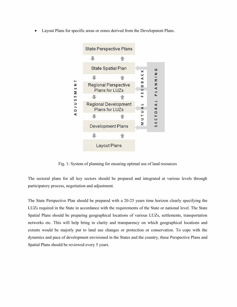
Layout Plans for specific areas or zones derived from the Development Plans.
Fig. 1: System of planning for ensuring optimal use of land resources
The sectoral plans for all key sectors should be prepared and integrated at various levels through
participatory process, negotiation and adjustment.
The State Perspective Plan should be prepared with a 20-25 years time horizon clearly specifying the
LUZs required in the State in accordance with the requirements of the State or national level. The State
Spatial Plans should be preparing geographical locations of various LUZs, settlements, transportation
networks etc. This will help bring in clarity and transparency on which geographical locations and
extents would be majorly put to land use changes or protection or conservation. To cope with the
dynamics and pace of development envisioned in the States and the country, these Perspective Plans and
Spatial Plans should be reviewed every 5 years.
The Land Utilisation Zones should be subject to land use planning taking into consideration the best
utilisation of land and designate the use of land required for various purposes. The Regional Perspective
Plan of LUZ should be prepared for a period of 20-25 years so as to reflect to long-term vision and
aligned to the Five Year Plans and other plan schemes and programmes of Central and State
Governments. The Regional Development Plan for the entire LUZ and Development Plans for individual
nodes or sub-zones of the regional plan should be prepared with 5 year time horizon. The 5-year
Development Plan should be conceived as a rolling plan to cope with the fast track changes and dynamics
of development that the zone may witness. Accordingly, the process of its review, revision, further
planning next phase and its approval should start at the third year and kept ready by the end of the 5th
year. The Local Area Plans are to be prepared to achieve development or re-development of land for
zones within the Development Plan. The implementation details should be specified in these plans.
Technical requirements:
For undertaking land use planning of LUZs uniformly across the country, the technical requirements
include:
Standardised land use classification system.
Standardised mapping scales.
Planning procedures be followed for plan preparation, plan approval, plan amendments etc.
Planning processes to be followed for involving stakeholders in plan preparation and plan
approval.
GIS based spatial and attribute database.
Land use change monitoring system.
For local area plans that guide the development, mapping in the scales of 1:5,000 or higher would be
required. For regional development plans, a scale of 1:25,000 and for Development Plans, a scale of
1:10,000 is recommended. For land use change monitoring, the potential scales of mapping for India are:
a) national level: 1:500,000; State level: 1:250,000 scale; District level: 1:50,000.
There is a need for technical staff for undertaking plan preparation and planning processes, and for
issuing approvals during plan implementation.

Planning steps:
The key planning steps to be followed for preparation of land use plans for the LUZs are (ref. Fig 2):
Data and information gathering, review and evaluation, including land information and associated
attribute data.
Identification of targets, goals and needs catering to development requirements, protection or
conservation requirements, and socio economic and environmental requirements.
Land suitability assessments and preparation of sectoral plans for all key sectors including rural,
agriculture, urban, industrial, environmental and transportation.
Appraisal of sectoral plans, negotiation and integration.
Plan approval.
Plan implementation.
Monitoring and evaluation.
Assessment of plan revision requirements.
Fig. 2: Key planning steps for Land Utilisation Zones
[LUZ - 1: Strategic Development Areas of National Importance; LUZ - 2: Urban Areas/Metropolitan Regions/ Areas
under transformation; LUZ - 3: Industrial Areas; LUZ - 4: Rural/Agricultural Areas; LUZ - 5: Transportation Corridors;
LUZ - 6: Mining and Mineral Bearing Areas; LUZ - 7: Ecological Areas; LUZ - 8: Tourism Areas, Heritage Areas;
LUZ - 9: Major Hazard Vulnerable Areas]
Planning principles:
Some important guiding principles to be followed for preparation of land use plans are given below:
Human beings are at the centre of concerns for sustainable development. They are entitled to a
healthy and productive life in harmony with nature.
Inclusive growth, poverty eradication and gender equality are indispensable requirements for
sustainable development of India, and must be addressed.
Developmental sectors and activities must be planned in a balanced and integrated manner to meet
economic, social and environmental needs of present and future generations to ensure inter
generational justice, and should aim to minimize displacement of population.
Long-term planning for optimum utilisation of land and conservation of scarce land resource is
essential and as far as possible, developmental projects should be set up on uncultivable lands,
recycled lands, wastelands, degraded lands or un-irrigated lands provided these are not performing
any other important function like bio-diversity, water resources etc.
Development planning must be comprehensive, sustainable, and integrated at various levels (national,
State, regional and local levels) taking into consideration the interest of all sectors and stakeholders,
including people concerned.
Apply uniform planning procedures and standards.
Sound planning processes should be applied so as to contribute to empowering communities and
women in planning and decision-making.
Ensure that lands that have important functions are preferably not altered in their land use.
Preferably conserve agricultural lands from land use conversions so as to ensure food security to meet
consumption needs of the growing population and to meet livelihood needs of the dependent
population.
Protect lands that are required to promote and support social development. Land use should be linked
to livelihood of rural and tribal populations. The rural employment programmes should be taken into
consideration. Also, rights of tribes and poorer sections on common land should be protected.
Conserve historic and cultural heritage by protecting places/sites of religious, archaeological, scenic
and tourist importance.
The natural resource areas including the biodiversity areas, forests areas etc. and ecosystem service
areas should be protected.

Land use shifts from one use to other use should be purely regulated by a land use plan (Development
Plan or a Master Plan). While preparing Development Plans, the amount of land use changes from
one use to another should be minimised. Once the Plan is prepared, the land use shifts should be
monitored through a sound monitoring system. There should be long-term targets on the extent of
land use changes that may be permitted from one use to other.
To cope with growing urbanisation needs, regional approaches should be adopted covering the zones
of spatial influence of the city, including lower order settlements. Regional planning should be
undertaken to establish proper hierarchy of settlements with the required infrastructure and services.
The transportation networks should be preferably integrated with State/regional/district plans. The
transportation corridors should e planned taking into consideration the other planned land uses and
the major upcoming new infrastructure.
c) Strengthening of Institutions and Coordinating Mechanisms
Land resource planning and management involves adjustment and negotiation to balance demands of
various sectors and various planning levels. Hence, the institutional mechanisms should include both
political and technical structures at national as well as state levels. The political structures should
include political heads of key sectoral ministries and representatives of States.
The technical structures are required at the national level for:
being a repository of spatial database;
developing methods, tools and techniques, as well as standardised planning procedures and
processes;
setting targets and monitoring of land use change; and
providing training and advisory support to planning institutions.
Technical structures are required at State and level levels for plan preparation, plan approval and plan
implementation.
Further, mechanisms are required to facilitate the active involvement and participation of
communities and people at local level.

5. Benefits of the Strategic Approach
The strategic approach detailed above would have multiple benefits as given below.
Helps in visualisation and translation of long-term social, economic and environmental goals into
physical plans that guide sustainable development.
Helps minimise land use conflicts and competition among sectors through orderly disposition.
Helps minimise negative impacts of pollution, climate change, social conflicts and disaster risks.
Helps achieve the developmental targets, as well as reforms and fast-track growth targets in line
with the agenda of the government and the people’s needs.
Contributes to food security and improved livelihood of rural population by proper planning of
rural and agricultural lands.
Contributes to protecting environmental sensitive zones and ecosystem services areas through
proper planning of such zones and the lands around them.
With well defined planning processes, contributes to empowering communities and women in
planning and decision-making.
6. Conclusion
A comprehensive and integrated land use planning system is a known solution to cope with the dynamics
of development and to ensure optimal utilization of land resources. However, in the absence of such an
elaborate planning system such as in India, a strategic and viable approach is required to be developed
and adopted. The suggested strategic approach is in line with the integrated land use planning and
management approach suggested in Agenda 21.
The approach for achieving integrated land use planning and management should have the key elements
of a) development of policies for optimal utilisation of land resources, b) improvement and strengthening
of planning, management, monitoring and evaluation systems, c) strengthening
of institutions, coordination and implementation mechanisms; and d) creation of mechanisms to facilitate
empowering communities and women in planning and decision-making.
The strategic approach suggested for India takes into consideration the existing constraints in
strengthening and improving such a planning for the entire country. At the same time, the approach also
takes into consideration the problems being faced due to pressure on land resources and the negative
impacts. The viable approach is to focus on identifying and planning of the Land Utilisation Zones that
are identified based on long-term perspective plans. The Land Utilisation Zones cover the land areas that
are or will be under pressure to undergo land use changes. These zones would cover a) lands for urban
development, industrial development, infrastructure development and mining, b) land zones that are to be
protected and regulated because of environmental sensitivity or cultural or historic heritage or touristic
importance, c) land zones for rural and agricultural development, and d) zones prone to natural or
manmade disaster risks.
The planning of the Land Utilisation Zones should be based on sound planning procedures and planning
principles integrating socio, economic and environmental demands, as well as the sectoral demands and
participatory processes so as to ensure sustainable development.
Such a strategic approach would support sustainable land use for an emerging country like India to
achieve its socio, economic and environmental goals and targets.

References:
1. Department of Land Resources, July 2013, “Draft National Land Utilization Policy”, Ministry of
Rural Development, Government of India
2. Deutsche Gesellschaft für Internationale Zusammenarbeit (GIZ) GmbH [Division Agriculture,
Fisheries and Food, Sector Project Land Policy and Land Management], February 2011, “Land Use
Planning - Concept, Tools and Applications”, Eschborn, Germany
3. Deutsche Gesellschaft für Technische Zusammenarbeit (GTZ) GmbH, 1999, “Land Use Planning
Methods, Strategies and Tools”, Eschborn, Germany
4. Directorate of Economics & Statistics, 2013, “Pocket Book on Agricultural Statistics 2013”,
Department of Agriculture & Cooperation, Ministry of Agriculture, Government of India
5. Food and Agriculture Organization (FAO), 1993, “Guidelines for Land-use Planning”, FAO
Development Series 1, United Nations Environment Programme, Rome
6. Food and Agriculture Organization (FAO), 1999, “The Future of Our Land - Facing The Challenge”,
United Nations Environment Programme, Rome
7. Ministry of Environment and Forests, 2007, “India’s Forests, Part 1”, Government of India, 2007
8. Ministry of Environment and Forests, 2008, “National Biodiversity Action Plan”, Government of
India
9. Ministry of Urban Affairs and Employment, 2014, “Urban and Regional Development Plans
Formulation and Implementation (UDPFI) Guidelines”, Volume 1, Government of India
10. Office of the Registrar General and Census Commissioner, 2011, “Census of India, 2011”, under
Ministry of Home Affairs, Government of India http://www.devinfolive.info/censusinfodashboard/
11. Pandey, C.M., 2012, “Utilization of Land Resources for Agriculture Sector in India-Present Practices
and Polices”, Department of Agriculture & Cooperation Ministry of Agriculture, Government of
India, New Delhi (http://www.landuseindia.in/live/hrdpmp/hrdpmaster/hrdp-
asem/content/e48335/e48799/e48940/e51439/e51486/9.UtilisationofLandResourcesbyAgricultureSec
torinIndia-PresentPracticesandPolicyRequirements_CMP.pdf)
12. The President of India, June 2014, “Address to the Parliament”, New Delhi
(http://presidentofindia.nic.in/speeches-detail.htm?293)
13. The United Nations Conference on Environment and Development (UNCED), 1993, “Agenda 21:
Programme of Action for Sustainable Development”, United Nations, New York