Embed Size (px)
Citation preview

Strategic Beach Management Plan:
Central Atlantic Coast Region Division of Water Resource Management
Florida Department of Environmental Protection
May 2018

Florida Department of Environmental Protection, Strategic Beach Management Plan – Central Atlantic Coast Region
May 2018, Page i
Table of Contents
Introduction – Central Atlantic ............................................................................................................... 1
Cape Canaveral ......................................................................................................................................... 1
Strategies for Inlets and Critically Eroded Beaches ............................................................................. 2
Kennedy Space Center, Brevard County, V065-V090 ......................................................................... 2
Canaveral Inlet, Brevard County, V167-R1 ......................................................................................... 2
Canaveral and Cocoa Beach (North Reach), Brevard County, R1-R53 ............................................... 4
Patrick Air Force Base, Brevard County, R53-R75.3 ........................................................................... 4
Satellite Beach and Indian Harbour (Mid-Reach), Brevard County, R75.3-R118 ............................... 5
Indialantic to Spessard Holland park (South Reach), Brevard County, R118-R139 ............................ 6
South Brevard County, R139 –R202 .................................................................................................... 7
Regional Strategies for Beach and Inlet Management .......................................................................... 7
Sponsors and Funding ........................................................................................................................... 7
Project Coordination ............................................................................................................................. 8
Environmental Protection ..................................................................................................................... 8
Sand Sources ......................................................................................................................................... 8
Additional Information ......................................................................................................................... 9
References ........................................................................................................................................... 11
Indian River Coast .................................................................................................................................. 14
Strategies for Inlets and Critically Eroded Beaches ........................................................................... 14
Sebastian Inlet, Brevard R219 to Indian River County R1 ................................................................. 14
Countywide Studies and Projects, Indian River County ..................................................................... 16
Ambersand Beach, Indian River County, R1–R17 ............................................................................. 16
Orchid Island and Wabasso Beach, Indian River County, R17-R51.3 ............................................... 18
Vero Beach, Indian River County, R70–R86 ..................................................................................... 18
South County Beach, Indian River County, R99–R115.7 .................................................................. 19
Regional Strategies for Beach and Inlet Management ........................................................................ 20
Sponsors and Funding ......................................................................................................................... 20
Project coordination ............................................................................................................................ 20
Environmental Protection ................................................................................................................... 20
Sand Sources ....................................................................................................................................... 21
Innovative Projects.............................................................................................................................. 21

Florida Department of Environmental Protection, Strategic Beach Management Plan – Central Atlantic Coast Region
May 2018, Page ii
Additional Information ....................................................................................................................... 21
References ........................................................................................................................................... 24
St. Lucie Beaches ..................................................................................................................................... 26
Strategies for Inlets and Critically Eroded Beaches ........................................................................... 26
Fort Pierce Inlet, St. Lucie County, R33-R34 ..................................................................................... 26
Fort Pierce, St. Lucie County, R34–R46 ............................................................................................ 27
Regional Strategies for Beach and Inlet Management ........................................................................ 29
Sponsors and Funding ......................................................................................................................... 29
Project Coordination ........................................................................................................................... 29
Environmental Protection ................................................................................................................... 29
Sand Sources ....................................................................................................................................... 30
Additional Information ....................................................................................................................... 30
References ........................................................................................................................................... 33
Treasure Coast ........................................................................................................................................ 35
Strategies for Inlets and Critically Eroded Beaches ........................................................................... 35
Walton Rocks, St. Lucie County, R80-R90.3 ..................................................................................... 35
South St. Lucie County Beaches, St. Lucie County, R98-R115+1000 (County Line) ....................... 35
Hutchinson Island, Martin County, R1-R34.3 .................................................................................... 36
Bathtub Beach and Sailfish Point, Martin County, R34.3-R40 .......................................................... 37
St. Lucie Inlet, Martin County, R44-R45 ........................................................................................... 38
Jupiter Island, Martin County, R45–R111 .......................................................................................... 39
Regional Strategies for Beach and Inlet Management ........................................................................ 41
Sponsors and Funding ......................................................................................................................... 41
Project Coordination ........................................................................................................................... 41
Environmental Protection ................................................................................................................... 41
Sand Sources ....................................................................................................................................... 42
Additional Information ....................................................................................................................... 42
References ........................................................................................................................................... 45
Appendix - Acronyms ................................................................................................................................ i

Florida Department of Environmental Protection, Strategic Beach Management Plan – Central Atlantic Coast Region
May 2018, Page iii
Jupiter Island Beach Nourishment Project, 2016. Photo courtesy of the Town of Jupiter Island.
Florida Department of Environmental Protection, Strategic Beach Management Plan – Central Atlantic Coast Region
May 2018, Page 1 of 46
Introduction – Central Atlantic The Central Atlantic Coast Region has a total of 136.6 miles of beaches of which, 82.9 miles are
critically eroded and 45.6 miles are actively managed. There are also four inlets within the Central
Atlantic Region, all of which have an inlet management plan. For additional beach management or
project information, see the current Critically Eroded Beaches Report, the joint coastal permits by
county or the local government funding requests by county. Each subregion listed below will have the
introductory paragraph listing miles of coastline and erosional events/storms that have affected the
subregion.
Each title within the subregion will list the coastal location, the county and the Department Reference or
Range (R monument) for the critical erosion area. For inlets, river entrances or passes, the title, the
county, and the adjacent R monuments will be stated. On federal lands near Cape Canaveral, virtual (V)
monuments are used to identify project locations. In addition, there will be a subregion map highlighting
the critical erosion areas and the managed project areas. Finally, references to coastal reports will also be
listed at the end of each subregion.
For more specific information concerning projects or strategies along Florida’s coastline, see the
following links for the other six coastal regions of Florida and for background information, see the
Strategic Beach Management Plan’s Introduction.
Strategic Beach Management Plan’s Introduction
Northeast Atlantic Coast Region
Southeast Atlantic Coast Region
Florida Keys Region
Southwest Gulf Coast Region
Big Bend Gulf Coast Region
Panhandle Gulf Coast Region
For additional information pertaining to beach and ocean conditions, coastal associations, educational
institutions or government agencies, see the following related coastal sites.
The State of Florida was significantly impacted by three hurricanes, Hermine, Matthew and Irma during
the 2016 and 2017 Atlantic Hurricane Seasons. To see additional information for strategies and funding
to address recovery for the beaches and dunes, see the “Hurricane Damage Assessment Report for 2016:
Florida’s Beaches and Dunes”. For the 2017 Hurricane season, see the “Hurricane Irma Post-Storm
Beach Conditions and Coastal Impact in Florida” report. The post-storm survey data has been fully

Florida Department of Environmental Protection, Strategic Beach Management Plan – Central Atlantic Coast Region
May 2018, Page 2 of 46
analyzed and an updated list of critically eroded beaches is in the Critically Eroded Beaches Report.
Cape Canaveral
The Cape Canaveral subregion has 71.6 miles of beaches, extending from the Volusia–Brevard County
line to the Sebastian Inlet at the Brevard–Indian River County line, as shown in Figure 1. There are 41.2
miles of critically eroded beaches in this subregion, of which 17.2 have been restored and maintained.
Erosion is attributed to frequent northeasters, occasional tropical storms and hurricanes, and the effects
of Canaveral Inlet. The most erosive storms in recent years were Hurricane David in 1979, northeasters
in November and December 1981, the Thanksgiving Day northeaster of 1984, Hurricane Erin (1995),
Hurricanes Floyd and Irene (1999), Tropical Storm Gabrielle (2001), Hurricanes Frances and Jeanne
(2004), Hurricanes Ophelia and Wilma (2005), Subtropical Storm Andrea, October northeasters and
Tropical Storm Noel (2007), Tropical Storm Fay (2008), Hurricane Sandy (2012), Hurricane Matthew
(2016) and Hurricane Irma (2017).
Strategies for Inlets and Critically Eroded Beaches
Kennedy Space Center, Brevard County, V065-V090
Kennedy Space Center was established in 1962 as a launch facility, and has been operating in that
capacity for over 50 years at Cape Canaveral. In 2012, a 4.7-mile segment along Kennedy Space
Center’s shoreline (V065-V090) was classified as critically eroded, and threatening manned spacecraft
facilities, launch pads, Phillips Parkway and buried infrastructure. A truck haul using upland sand that
was stockpiled in the Cape Canaveral Air Force Station, placed 85,000 cubic yards (cy) in Spring 2014
to rebuild and reinforce dunes in the Kennedy Space Center. Additional beach and dune restoration is
being investigated and currently the DRAFT Environmental Assessment for KSC Shoreline Protection
Project of March 2015 is under review for evaluating the best alternatives for shoreline protection.
Strategy: Coordinate beach and dune erosion control activities with the Kennedy Space Center.
Canaveral Inlet, Brevard County, V167-R1
In 1939, the Florida Legislature created the Canaveral Port District, which obtained funding authority in
1941. In 1945, the U.S. Congress, under the Rivers and Harbors Act, authorized construction of a deep-
water harbor and channel on the recurving shoreline immediately south of Cape Canaveral. Canaveral
Inlet was constructed in 1951 as part of the federal Canaveral Harbor Navigation Project at Port

Florida Department of Environmental Protection, Strategic Beach Management Plan – Central Atlantic Coast Region
May 2018, Page 3 of 46
Canaveral. The port and harbor construction was completed in September 1954. The lock that connects
the west turning basin to the barge canal was constructed in 1965. Maintenance dredging of the entrance
channel generally occurs on an annual or biannual basis with placement of the dredged material within a
nearshore or offshore disposal area. The high percentage of fine grain sediment in the dredged material
has precluded beach placement. The Sand Bypass I project was constructed in 1995, which bypassed
930,000 cy to R1 to R8. The Sand Bypass II project was constructed in 1998, which bypassed 1,000,000
cy of sand using material from the nearshore or beach zone north of the inlet and placing it on the beach
south of the inlet between R3 and R14. Sand-tightening improvements to the south jetty were completed
in 1995. The Florida Department of Environmental Protection (Department or DEP) adopted an inlet
management plan (IMP) in 1996 to implement strategies for bypassing objectives and comprehensive
monitoring. The Strategic Beach Management Plan of 2008 further adopted a minimum average annual
bypassing objective of 156,000 cy to be placed to the south of Port Canaveral Inlet. Dredging was
performed in 2004 to remove material shoaled in during Hurricane Frances. Sand-tightening
construction and a 300-ft seaward extension of the north jetty were completed in November 2005. Sand
bypassing was completed in December 2007 for the Sand Bypass III project, with placement of 750,000
cy between R3.5 and R10. Sand bypassing occurred again in the spring of 2010 for the Sand Bypass IV
project, with placement of 683,100 cy between R2.3 and R3, and also between R4 and R12.6. A study
was completed in 2014 to update the inlet’s sediment budget. DEP subsequently adopted the Port
Canaveral Inlet Management Plan (2014). The next and fifth sand bypassing event (SB-V) is scheduled
for 2017. Learn more about Port Canaveral projects and history.
Strategy: Follow the strategies listed in the updated (2014) Port Canaveral IMP. (1) Continue the
existing comprehensive beach and inlet hydrographic monitoring program. (2) Continue the authorized
inlet sand bypassing protocol. (3) The average annual bypassing objective shall achieve a minimum
placement of 156,000 cy per year. (4) In order to bypass the natural net annual longshore sediment
transport (approximately 210,000 cy), in addition to the minimum bypassing quantity in Strategy #3, an
additional quantity equal to at least 54,000 cy per year equivalence of beach quality material shall be
placed between R20 and R75, with priority placement south of R42. (5) All suitable material from
maintenance dredging the Canaveral Harbor Entrance and the south jetty sediment trap containing less
than 20 percent fines shall be placed in the authorized nearshore disposal area in the vicinity of R28 to
R38 offshore from Cocoa Beach.

Florida Department of Environmental Protection, Strategic Beach Management Plan – Central Atlantic Coast Region
May 2018, Page 4 of 46
Canaveral and Cocoa Beach (North Reach), Brevard County, R1-R53
This is a 9.4-mile segment of critically eroded beach in central Brevard County from the south jetty at
Canaveral Inlet (R1) to the south limits of Cocoa Beach (R53). The project history for this segment of
shoreline is described in Table 1. The federal Brevard County Shore Protection Project was constructed
in 2001. The project design consists of a beach berm at elevation +9 ft NGVD to protect the existing
dune and upland development. The project is authorized until 2050. Following the effects of the 2004
hurricane season, nourishment was accelerated and constructed during the spring of 2005. Due to
erosion from Hurricane Sandy, the North Reach was nourished again in 2014, with the assistance of
FCCE funds. The next nourishment was completed in April 2018 and placed approximately 825,616 cy
of beach quality material in the North Reach from an offshore borrow site.
Table 1. Brevard County Shore Protection Project - North Reach project history.
Date Completed Volume (cy) Sand Source Project Location
(by R monument) Length (mi.)
April 2001 3,140,000 Offshore -
Canaveral Shoals II
R3-R53 9.1
May 2005 754,600 Offshore -
Canaveral Shoals II
R4-R20 and R33-R45 5.9
April 2014 972,410 Offshore -
Canaveral Shoals II
R6-R24 and R33-R54 7.4
April 2018 825,616 * Offshore -
Canaveral Shoals II
R3.5-R22.5 and R34-R54 8.7
* Contract/ Pay volume.
Strategy: Maintain the project through monitoring, inlet sand bypassing and nourishment.
Patrick Air Force Base, Brevard County, R53-R75.3
This is a 4.0-mile segment of critically eroded beach extending the length of Patrick Air Force Base. The
project history for this segment of shoreline is described in Table 2. The Patrick Air Force Base Beach
Restoration Project was constructed between December 2000 and April of 2001. Following the effects
of the 2004 hurricane season, nourishment was accelerated and constructed during the spring of 2005. A
dune restoration project was constructed in 2011, placing 51,200 cy of material along two miles of
shoreline between R64.5 and R75.3. A small dune project occurred in 2014, placing 17,000 cy of
material between R64.5 and R70.

Florida Department of Environmental Protection, Strategic Beach Management Plan – Central Atlantic Coast Region
May 2018, Page 5 of 46
Table 2. Patrick Air Force Base Beach Nourishment Project history.
Date Completed Volume (cy) Sand Source Project Location
(by R monument) Length (mi.)
April 2001 600,000 Offshore - Canaveral Shoals II R53-R70 3.2
March 2005 258,300 Offshore - Canaveral Shoals II R54.5-R65 3.9
March 2005 63,200 Offshore - Canaveral Shoals II R65-R75.4 2.0
2011 51,200 Nearshore north of Port Canaveral’s
north jetty R64.5-R75.3 2.0
2014 17,000 Upland Mine R64.5-R70 1.0 Strategy: Maintain the project through monitoring and nourishment.
Satellite Beach and Indian Harbour (Mid-Reach), Brevard County, R75.3-R118
This is a 7.7-mile segment of critically eroded beach beginning at the southern boundary of Patrick Air
Force Base and extending to just north of Indialantic. This area includes the communities of Satellite
Beach and Indian Harbour Beach (R80-R104). Following the effects of the 2004 hurricane season, the
design and permitting of a beach restoration project at the Mid-Reach segment of the federal Brevard
County Shore Protection Project is ongoing. The project is authorized until 2050. In the interim, dune
restoration projects were constructed in 2005, 2006, 2008, 2009, and 2014. This work maintained the
emergency protective berms partially funded by the state in 2005; 2008 and 2014 were fully funded by
the Federal Emergency Management Agency (FEMA), with additional sand and vegetation in
2006/2009. Dune restoration occurred in 2014, placing 191,770 cy of material in the Mid-Reach in
response to damages sustained during Hurricane Sandy. Between 2005 and 2014, these projects have
placed a total of 814,253 cy of sand on the Mid-Reach shoreline. The Department issued a permit in
December 2009 for the restoration project, and the federal permit was issued in 2012. The project has
been delayed for modifying the design plans for the project. Construction of the reef modules is
scheduled for completion by October 2018 or early 2019 and sand placement is scheduled for
2020/2021. The mitigation reef will be constructed first, followed by the beach restoration project.
Strategy: Construct and maintain the Mid-Reach segment of the Brevard County Shore Protection
Project; nourish dune as needed; monitor.

Florida Department of Environmental Protection, Strategic Beach Management Plan – Central Atlantic Coast Region
May 2018, Page 6 of 46
Indialantic to Spessard Holland park (South Reach), Brevard County, R118-R139
This is a 3.8-mile segment of critically eroded beach beginning at Indialantic and extending to Spessard
Holland Park. The project history for this segment of shoreline is described in Table 3. Beach restoration
was initially conducted in 1980, but was not maintained. A subsequent beach restoration project was
completed in two segments. Segment I (R122.5-R139) was completed between February and April
2002. Segment II (R118.3-R123.5) was completed between March and April 2003. Following the effects
of the 2004 hurricane season, nourishment of this project, referred to as the South Reach segment of the
federal Brevard County Shore Protection Project, was accelerated. The project design consists of a beach
berm at elevation +9 ft NGVD to protect the existing dune and upland development. The project is
authorized until 2050. Beach nourishments were constructed during the spring of 2005, spring 2010 and
early winter of 2014. The next nourishment was completed in April 2018 and placed approximately
273,312 cy of beach quality material in the South Reach from an offshore borrow site.
Table 3. Brevard County Shore Protection Project - South Reach project history.
Date Completed Volume (cy) Sand Source Project Location
(by R monument) Length (mi.)
1980 No data Trident Submarine Base Indialantic Beach No data
April 2003 1,431,000
Offshore -Space Coast Shoals II and Canaveral Shoals
II
R118.3-R139 3.8
April 2005 578,910 Offshore -
Canaveral Shoals II
R118-R139 3.8
April 2010 650,000 Offshore -
Canaveral Shoals II
R118-R139 3.8
February 2014 692,418
Offshore - Canaveral Shoals
II R118-R139 3.8
April 2018 273,312 * Offshore -
Canaveral Shoals II
R118.5-R127 and R132-R139 2.9
* Contract/ Pay volume.
Strategy: Maintain the project through monitoring and nourishment.

Florida Department of Environmental Protection, Strategic Beach Management Plan – Central Atlantic Coast Region
May 2018, Page 7 of 46
South Brevard County, R139 –R202
This is an 11.5-mile segment of critically eroded beach. Following the effects of the 2004 hurricane
season, emergency protective berms were funded by FEMA and the Department. Dune restoration
projects were constructed in 2005, 2006, 2008, 2009, and 2014 to maintain the emergency protective
berms with additional sand and vegetation. Between 2005 and 2014, these projects have placed 447,312
cy of sand on the South Beaches of Brevard. The dune restoration that occurred in 2014 placed 47,262
cy of upland material in the South Beaches. A state and local feasibility study was initiated in 2007 to
study economic costs and benefits of storm-damage reduction associated with construction of an erosion
control project along the 14.5-mile shoreline (R139-R219) of the Southern Brevard County study area.
The study concluded that there were two shoreline reaches with potential net storm damage reduction
benefits that are greatest, relative to project costs from a beach nourishment project. The two reaches are
Reach A from R139 to R149.3 (1.8 miles), which is south of the existing South Reach project area, and
Reach C between R164.5 to R176 (2.2 miles). Construction of a nearshore placement project in Reach A
(R141-R151) has been permitted for the South Beaches. The proposed project is to place approximately
150,000 cy of beach compatible material in the nearshore at water depths of -24ft to -11ft NAVD 88.
The South Beaches received emergency dune restoration due to Hurricane Matthew beginning in late
October 2016, with upland sand placement in the amount of 99,384 cy between R143 to R213, the
project was completed in March 2017.
Strategy: Maintain the dune project; construct a nearshore placement project and monitor.
Regional Strategies for Beach and Inlet Management
Sponsors and Funding
This subregion contains the governmental entities of Brevard County, the cities of Cape Canaveral,
Cocoa Beach, Satellite Beach, Indian Harbour Beach, Melbourne, Indialantic, Melbourne Beach, the
Canaveral Port Authority and the U.S. Army Corps of Engineers (USACE). The beaches of Cape
Canaveral are within the Canaveral National Seashore, Kennedy Space Center and Cape Canaveral Air
Force Base. Patrick Air Force Base includes 4 miles of shoreline on Canaveral Peninsula. Participants
with the Department as sponsors of beach management projects include Brevard County, the Canaveral
Port Authority, and the USACE. The sand bypass projects at Port Canaveral in 1995, 1998, 2007, and
2010 were carried out by the USACE, and were 100 percent federally funded. The USACE agreed to
provide 100 percent federal cost share for construction of the North Reach in 2009, due to the results of

Florida Department of Environmental Protection, Strategic Beach Management Plan – Central Atlantic Coast Region
May 2018, Page 8 of 46
the independent coastal expert (ICE) study. Project cost estimates may be found in the Beach
Management Funding Assistance Program - Long Range Budget Plan.
Project Coordination
Regionalization is the funding and coordination of multiple erosion control projects and inlet
management activities to take advantage of identifiable cost savings through economies of scale,
reduced equipment mobilization and demobilization costs, and elimination of duplicative administrative
tasks. Opportunities in this subregion include the implementation of maintenance dredging and sand
bypassing at Canaveral Inlet, which should and has been coordinated as much as possible with
nourishment of the Brevard County Shore Protection Project. The USACE has acknowledged that 100
percent of the North Reach and Canaveral Inlet Sand Bypassing “construction costs” are federal
responsibility to mitigate the impacts of the Canaveral Inlet impacts. The coordination between the
Canaveral Port Authority, Brevard County and USACE represents one of the state’s better examples of
regional sediment management (RSM) to bypassing inlet material (R1-R14) and maintaining the North
Reach Shore Protection Project (R1-R53) of Brevard County.
Environmental Protection
The protection of marine turtles, right whales, beach mice, shorebirds and the nearshore hardbottom and
sabellariid worm reef communities are primary environmental concerns within this subregion. The
timing of construction activities has been restricted during the annual marine turtle nesting season (May
1 through October 31). The Archie Carr National Wildlife Refuge is within – and in close proximity to –
the beach projects of this subregion. Project design and method of construction may be restricted to
avoid or minimize adverse impacts to the listed species and their habitat. The operation of hopper
dredges is restricted to avoid adverse impacts to marine turtles and right whales. The boundaries of
project activities have been limited to avoid impacts to hardbottom and worm reef communities.
Sand Sources
Sand sources identified in a previous study and during design of the inlet bypassing and beach
restoration projects appear to contain sufficient material for nourishment during the next 15 years. The
Canaveral Shoal is estimated to contain more than 100 million cubic yards of beach compatible sand.
However, borrow sources more conveniently located offshore of central and southern Brevard County
are being investigated. A regional sediment management strategy that uses beach quality sand from
upland dredged material management areas (DMMA) and the maintenance dredging of the navigation

Florida Department of Environmental Protection, Strategic Beach Management Plan – Central Atlantic Coast Region
May 2018, Page 9 of 46
project has been incorporated into the maintenance of the beach restoration projects since the mid-
1990s.
There is continued coordination between the Department, the USACE, Bureau of Ocean Energy
Management (BOEM) and local governments to use best management practices with these offshore
resources, and also determine where sand borrow sites are located offshore along the Atlantic shoreline.
For additional information on sand sources, the Department manages the Regional Offshore Sand
Source Inventory (ROSSI) database.
Additional Information
The introduction of the state’s Strategic Beach Management Plan provides additional background
information on the Department’s Beach Management Programs, and includes overviews of:
• The principals and statutes followed to help guide the state’s management strategies
• Comprehensive list of Florida’s inlets
• The miles of critically eroded beaches under active management
• Statewide sand source studies
• Statewide monitoring programs
• Innovative technologies examined
• Basic suggestions for emergency response plans

Florida Department of Environmental Protection, Strategic Beach Management Plan – Central Atlantic Coast Region
May 2018, Page 10 of 46
Figure 1. Map of the beaches of Brevard County, including Cape Canaveral. View an interactive map or COASTS imagery.

Florida Department of Environmental Protection, Strategic Beach Management Plan – Central Atlantic Coast Region
May 2018, Page 11 of 46
References
Balsillie, J. H., 1985. Post-Storm Report: The Florida East Coast Thanksgiving Holiday Storm of 21-24
November 1984, Florida Department of Natural Resources, Division of Beaches and Shores, Post-
Storm Report No. 85-1, 74 p.
Bodge, K.R., 1994. Port Canaveral Inlet Management Plan, Olsen Associates, Inc., Jacksonville, FL.
Bodge, K., 2002. Brevard County, Florida Shore Protection Project, North Reach and Patrick Air Force
Base Beach Fill: One-Year Post Construction Physical Monitoring Report 2002, Olsen
Associates, Inc.
Clark, R.R., LaGrone, J.W., and Koch, J.L, 2006. Hurricane Wilma: Post-Storm Beach Conditions and
Coastal Impact Report, Florida Department of Environmental Protection, Bureau of Beaches and
Coastal Systems, 98 p.
Clark, R.R., LaGrone, J.W., Brantly, R.., 2004. Hurricane Frances & Hurricane Jeanne: Post-Storm
Beach Conditions and Coastal Impact Report with Recommendations for Recovery and
Modifications of Beach Management Strategies, Florida Department of Environmental Protection,
Bureau of Beaches and Coastal Systems, 93 p.
Clark, R.R., 2000. The Impact of Hurricanes Floyd and Irene on the Florida East Coast, Florida
Department of Environmental Protection, Bureau of Beaches and Coastal Systems, Report No. 00-
01, 55 p.
Florida Department of Environmental Protection. 2004 Hurricane Recovery Plan for Florida’s Beach
and Dune System, 65 p.
Florida Department of Environmental Protection, 2017. Critically Eroded Beaches in Florida, Division of
Water Resource Management, 89 p.
Florida Department of Environmental Protection, 1996. Port Canaveral Inlet Management Study
Implementation Plan, 8 p.
Florida Department of Environmental Protection, 2014. Port Canaveral Inlet Management Plan, August
2014, 8 p.

Florida Department of Environmental Protection, Strategic Beach Management Plan – Central Atlantic Coast Region
May 2018, Page 12 of 46
Hunt, S.D., 1980. Port Canaveral Entrance, Glossary of Inlets Report No. 9, University of Florida, Florida
Sea Grant Report Number 39, 50 p.
Kriebel, D., Weggel, R., Dalrymple, R., 2002. Independent Study Report: Brevard County, Florida Shore
Protection Project, Independent Coastal Expert Team Report prepared for U.S. Army Corps of
Engineers, Jacksonville District, 92 p.
Olsen Associates, Inc., 2012. Brevard County, Florida, Port Canaveral Inlet Management Plan, 2011
Sediment Budget Update (April 2012).
Olsen Associates, Inc., 2014. Port Canaveral Inlet Management Plan: 2013 Sediment Budget Update, 231
p (April 2014).
Olsen Associates, Inc., 2011. Brevard County, Florida, Federal Shore Protection Project, South Reach
Beach Fill: 2010 Project Renourishment, 1-Year Post-Construction Physical Monitoring Report
(November 2011).
Olsen Associates, Inc., 2009. Brevard County, Florida, Engineered Berm Project for Shore Protection
Along Central and Southern Brevard County, Florida (2005-2009).
Olsen Associates, Inc., 2006a. Brevard County, Florida, Federal Shore Protection Project, South Reach
Beach Fill: 2005 Project Renourishment, 1-Year Post-Construction Physical Monitoring Report
(May 2005 to May 2006).
Olsen Associates, Inc., 2006b. Brevard County, Florida, Federal Shore Protection Project, North Reach
and Patrick Air Force Base Beach Fill: 2005 Project Renourishment, One-Year Post-Construction
Physical Monitoring Report (6/05-5/06).
Olsen Associates, Inc., 1994. Port Canaveral Inlet Management Plan Technical Report.
Olsen Associates, Inc., 1989. Sand Source Analyses for Beach Restoration Brevard County, Florida.
NASA-KSC, 2015. DRAFT Environmental Assessment for KSC Shoreline Protection Project, 170 p.
U.S. Army Corps of Engineers, 1989. Canaveral Harbor, Florida – Sand Bypass System, General Design
Memorandum.

Florida Department of Environmental Protection, Strategic Beach Management Plan – Central Atlantic Coast Region
May 2018, Page 13 of 46
U.S. Army Corps of Engineers, 1993. Canaveral Harbor, Florida Sand Bypass System, General
Reevaluation Report with Environmental Assessment.
U.S. Army Corps of Engineers, 2012. Canaveral Harbor Sand Bypassing Project Brevard County,
Florida 2010 Phase IV Bypassing, Year One Post Construction Monitoring Report.
U.S. Army Corps of Engineers, 1998. Water Resources Development in Florida.
U.S. Army Corps of Engineers, 1996. Brevard County, Florida Shore Protection Project Review Study,
Feasibility Report with Final Environmental Impact Statement.
Walton, T., 1995. Limited Response Sub Study for Brevard County Erosion Mitigation, U.S. Army Corps
of Engineers.

Florida Department of Environmental Protection, Strategic Beach Management Plan – Central Atlantic Coast Region
May 2018, Page 14 of 46
Indian River Coast
There are 22.4 miles of beaches in the Indian River Coast subregion, which extends from Sebastian Inlet
to the Indian River–St. Lucie County line, as shown on Figure 2. There is a total of 15.7 miles of
critically eroded beaches in this subregion, of which 11.0 miles have been restored and maintained.
Erosion is attributed to frequent northeasters, occasional tropical storms and hurricanes, and the effects
of Sebastian Inlet. The most erosive storms in recent years were Tropical Storm Gilda (1973), a
northeaster in October of 1974, Hurricane David (1979), the Thanksgiving Day Northeaster of 1984, the
Halloween Day Northeaster of 1991, Hurricane Erin (1995), Hurricanes Floyd and Irene (1999),
Tropical Storm Gabrielle (2001), Hurricanes Frances and Jeanne (2004), Hurricane Wilma (2005), and
Subtropical Storm Andrea, October northeasters, Tropical Storm Noel (2007), Tropical Storm Fay
(2008), Hurricane Sandy (2012), Hurricane Matthew (2016) and Hurricane Irma (2017).
Strategies for Inlets and Critically Eroded Beaches
Sebastian Inlet, Brevard R219 to Indian River County R1
Sebastian Inlet is a man-made tidal inlet that was constructed in its present position in 1948, and is
maintained by the Sebastian Inlet District. Sebastian Inlet State Park encompasses both the north and
south sides of the inlet. Maintenance dredging of the channel and sediment impoundment basin (sand
trap) occurs regularly, with placement of suitable material on the downdrift beaches south of the inlet.
The Department adopted the Sebastian Inlet Management Study Implementation Plan in March 2000,
which prescribed a bypassing requirement of 70,000 cy per year. The Department convened a new
Technical Advisory Committee (TAC) in June 2004 for Sebastian Inlet. After examining available data,
reports and analyses related to Sebastian Inlet, its sediment budget, and its impact on adjacent
shorelines, the TAC recommended an updated bypassing objective of 90,000 cy on an average annual
basis. This objective was never established in an updated inlet management plan, but was adopted within
the strategies in the 2008 strategic beach management plan. In an effort to meet the bypassing objective,
the District places material from dredging of the navigation channel and sand trap on the downdrift
beaches. In addition to placement of maintenance dredge material, sand from upland sources has been
placed on the beaches south of the inlet to meet the bypassing requirement. Recent efforts by Sebastian
Inlet District have included the construction of the 300,000 cy capacity Dredge Material Management
Area (DMMA) in 2011 to allow for more efficient processing of dredge material, re-alignment of the

Florida Department of Environmental Protection, Strategic Beach Management Plan – Central Atlantic Coast Region
May 2018, Page 15 of 46
inlet channel to improve navigability and increase dredge maintenance intervals, and expansion of the
existing sand trap to increase structure efficiency and capacity.
Sebastian Inlet District has also implemented a comprehensive beach and inlet monitoring and modeling
program to quantify inlet processes. This effort includes biannual surveys of the inlet and adjacent
beaches, collection of local wave and water level data, and modeling of inlet processes. Placements
within the DMMA consist of a range of material (silt/clay, sand and rock) that is not immediately beach
compatible. The DMMA allows for sorting and screening of this material to recover beach compatible
material, which is subsequently placed on the beach. Learn more about Sebastian Inlet projects and the
inlet history from the District’s web pages.
Following the impacts of Hurricane Francis and Jeanne in 2004, a project was constructed in the spring
of 2007 between R4 and R17, using approximately 85,700 cy of beach quality sand that was dredged
from the sediment impoundment basin of Sebastian Inlet. Additional material was placed on the beach
south of the inlet in 2007 in the amount of 204,900 cy, from an offshore sand source that was placed on
the beach south of the inlet. A newly constructed sediment impoundment basin, or Dredge Material
Management Area (DMMA), was constructed in 2011 within Sebastian Inlet State Park that is capable
of holding up to 30,000 cy of dredge material. Maintenance dredging of the sand trap and channel in the
amount of 141,251 cy and 119,851 cy was placed on the beach and the remainder (21,400 cy) was
placed in the DMMA in 2012 for phase I of the project. The beach quality material was placed along the
beaches south of the inlet between R4 – R8.5. Additional material of 34,600 cy was placed on the beach
between R8.5 and R17 in 2013.
The Sebastian Inlet District removed 160,539 cubic yards of material from the Sebastian Inlet interior
sand trap in 2014 through hydraulic excavation. Of this volume, 111,242 cubic yards of beach
compatible material and was placed on the beach between R3 and R7. The remaining 49,297 cubic yards
was placed in the DMMA. The Sebastian Inlet District performed a Screening and Truck Haul Beach
Placement Project in February 2015 using material stored in the DMMA, which resulted in
approximately 55,818 cubic yards of material being placed on the downdrift beaches between R11 and
R17. The Sebastian Inlet District later placed 30,742 cy of material from the DMMA between R10 and
R17 in 2017 in response to Hurricane Matthew.
Strategy: Continue to bypass suitable sediment to the beaches south of the inlet from dredging of the
inlet sand trap and from alternative sources as needed, to meet or exceed an average annual placement
objective of 90,000 cy; maintain beaches south of the inlet that have been restored; implement a

Florida Department of Environmental Protection, Strategic Beach Management Plan – Central Atlantic Coast Region
May 2018, Page 16 of 46
comprehensive beach and inlet monitoring program and based on the data, update the sediment budget
and inlet management plan.
Countywide Studies and Projects, Indian River County
In 1986, the federal Indian River County Shore Protection Project was authorized for the Atlantic
shoreline of Sebastian Inlet State Park (1.7 miles) and the City of Vero Beach (1.7 miles), with periodic
nourishment. Studies completed in 1987 showed that it was economically feasible to extend the Vero
Beach segment northward 0.9 miles to Tracking Station County Park. The project has not been
implemented to date. A limited re-evaluation report of the Vero Beach segment was completed in 2000
by the USACE.
In 1988, the Indian River County Board of County Commissioners adopted a Beach Preservation Plan,
which has been updated in 1998, 2008, and 2015. This plan divided the county into eight sectors. The
updated plan proposed restoration and maintenance of beaches that have been impacted by the presence
of Sebastian Inlet, and beach restoration and maintenance of critically eroded beaches within the
remainder of the county. In 1999, a feasibility study of beach management alternatives was performed,
along with preliminary engineering and design for beach and dune restoration. As of 2016, most of the
alternatives contained in this plan have been implemented. Based upon available records from 1978 to
present, the county, Sebastian Inlet District, City of Vero Beach and private residents have placed
approximately 3.6 million cy along the county’s shoreline. Of this volume, approximately 2.2 million cy
have been placed since 2002. After Hurricane Matthew (2016), Indian River County placed a total of
112,500 cy of upland material for emergency dune and beach repair between R10 and R105.4. The
strategy for each segment of shoreline in Indian River County is presented below.
Ambersand Beach, Indian River County, R1–R17
This is a 3.1-mile segment of critically eroded beach immediately south of Sebastian Inlet that includes
Sebastian Inlet State Park (R1-R4) and unincorporated Ambersand Beach (R4-R17). This segment of
beach includes Sector 1 (R1-R11) and Sector 2 (R11-R17) in the county’s Beach Preservation Plan.
Sand from inlet bypassing is placed within the area from R4 to R17. The non-federal Ambersand
Beach Nourishment Project was initially constructed from February to April of 2003 by Indian River
County using an offshore sand source. The project design consisted of a beach berm at elevation +9
ft NGVD, and a dune crest elevation at +14 ft NGVD that constitutes six years of advance nourishment
to protect the existing dune and upland development. During this 2003 project, approximately 536,600
cy of beach quality sand was placed between R3.5 and R17. The project constructed 6.6 acres of

Florida Department of Environmental Protection, Strategic Beach Management Plan – Central Atlantic Coast Region
May 2018, Page 17 of 46
artificial reef to mitigate for adverse impacts to 3.8 acres of nearshore hardbottom. A physical and
environmental monitoring program was implemented in conjunction with project construction.
Following the impacts of Hurricane Francis and Jeanne in 2004, FEMA funded the construction of
emergency protective berms. The project was constructed in the spring of 2007 between R4 and R12,
using approximately 85,700 cy of beach quality sand that was dredged from the sediment impoundment
basin of Sebastian Inlet. Additional material in the amount of 204,900 cy from an offshore borrow
source was placed on the beach between R4 and R17 in December 2007. Maintenance dredging of the
Sebastian Inlet sand trap and channel in the amount of 119,851 cy was placed on the beach in 2012
between R4 and R8.5 for phase I of the project. Additional material was placed on the beach between
R8.5 and R17 in 2013 in the amount of 34,600 cy. Material in the amount of 111,200 cy was placed on
the beach between R4 and R7 in 2014. Phase II maintenance dredging was completed in February 2015
to remove sand and rock from the sand trap, and beach compatible material of approximately 55,818 cy
was placed in the Ambersand project area between R11 and R17. See project history in Table 4.
Table 4. Ambersand (Sectors 1 & 2) Project placement history.
Date Completed Volume (cy) Sand Source Project Location
(by R monument) Length (mi.)
April 2003 536,600 Offshore R3.5-R17 2.6
April 2007 85,700 Inlet R4-R12 1.5
December 2007 204,900 Offshore R4-R17 2.5
2012 119,851 Inlet R4-R8.5 0.9
2013 34,600 Inlet R8.5-R17 1.6
2014 111,242 Inlet R3-R7 0.8
February 2015 55,818 Inlet R11-R17 1.1
Florida Department of Environmental Protection, Strategic Beach Management Plan – Central Atlantic Coast Region
May 2018, Page 18 of 46
Strategy: Maintain the project through monitoring and nourishment using sand from inlet bypassing and
alternate sources.
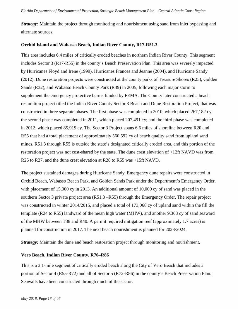
Orchid Island and Wabasso Beach, Indian River County, R17-R51.3
This area includes 6.4 miles of critically eroded beaches in northern Indian River County. This segment
includes Sector 3 (R17-R55) in the county’s Beach Preservation Plan. This area was severely impacted
by Hurricanes Floyd and Irene (1999), Hurricanes Frances and Jeanne (2004), and Hurricane Sandy
(2012). Dune restoration projects were constructed at the county parks of Treasure Shores (R25), Golden
Sands (R32), and Wabasso Beach County Park (R39) in 2005, following each major storm to
supplement the emergency protective berms funded by FEMA. The County later constructed a beach
restoration project titled the Indian River County Sector 3 Beach and Dune Restoration Project, that was
constructed in three separate phases. The first phase was completed in 2010, which placed 267,182 cy;
the second phase was completed in 2011, which placed 207,491 cy; and the third phase was completed
in 2012, which placed 85,919 cy. The Sector 3 Project spans 6.6 miles of shoreline between R20 and
R55 that had a total placement of approximately 560,592 cy of beach quality sand from upland sand
mines. R51.3 through R55 is outside the state’s designated critically eroded area, and this portion of the
restoration project was not cost-shared by the state. The dune crest elevation of +12ft NAVD was from
R25 to R27, and the dune crest elevation at R28 to R55 was +15ft NAVD.
The project sustained damages during Hurricane Sandy. Emergency dune repairs were constructed in
Orchid Beach, Wabasso Beach Park, and Golden Sands Park under the Department’s Emergency Order,
with placement of 15,000 cy in 2013. An additional amount of 10,000 cy of sand was placed in the
southern Sector 3 private project area (R51.3 –R55) through the Emergency Order. The repair project
was constructed in winter 2014/2015, and placed a total of 173,068 cy of upland sand within the fill the
template (R24 to R55) landward of the mean high water (MHW), and another 9,363 cy of sand seaward
of the MHW between T38 and R40. A permit required mitigation reef (approximately 1.7 acres) is
planned for construction in 2017. The next beach nourishment is planned for 2023/2024.
Strategy: Maintain the dune and beach restoration project through monitoring and nourishment.
Vero Beach, Indian River County, R70–R86
This is a 3.1-mile segment of critically eroded beach along the City of Vero Beach that includes a
portion of Sector 4 (R55-R72) and all of Sector 5 (R72-R86) in the county’s Beach Preservation Plan.
Seawalls have been constructed through much of the sector.

Florida Department of Environmental Protection, Strategic Beach Management Plan – Central Atlantic Coast Region
May 2018, Page 19 of 46
This area was severely impacted by Hurricanes Frances and Jeanne (2004). Following the effects of the
2004 hurricane season, emergency protective berms were constructed using funds from FEMA. A dune
restoration project consisting of additional sand and vegetation was constructed in 2005 to supplement
the emergency protective berms being funded by FEMA. Another dune restoration project was
conducted at the Conn Beach Access in March 2008. The County’s Beach Preservation Plan
recommends beach nourishment for the Sector 5 segment. The County is currently developing a
feasibility study and environmental assessment, for USACE’s and the Department’s review, in order to
determine the preferred alternative to manage this segment of critically eroded beach.
Strategy: Maintain the dune restoration project; develop design alternatives for environmentally
acceptable beach management.
South County Beach, Indian River County, R99–R115.7
This is a 3.1-mile segment of critically eroded beach in southern Indian River County. This segment of
beach includes most of Sector 7 (R97-R108) and a portion of Sector 8 (R108-R119) in the county’s
Beach Preservation Plan. Seawalls have been constructed along much of the area. This area was severely
impacted by Hurricanes Floyd and Irene (1999) and Hurricanes Frances and Jeanne (2004). Following
the effects of the 2004 hurricane season, emergency protective berms were constructed using funds from
FEMA. A dune restoration project consisting of additional sand and vegetation was constructed in 2005
to supplement the emergency protective berms funded by FEMA. The Indian River County Sector 7
Beach Restoration Project was completed in the spring of 2007, which placed approximately 348,500 cy
of beach quality sand between R97 and R108 using an offshore borrow site. Sixty-three percent of the
total volume of sand was placed at the northern portion (R97-R102) of the project area, and was
designed to be wider than the southern portion (R102-R108) to serve as a feeder beach. The northern
portion (42 percent of total length) of the project has shown significant loss of material that was placed,
while the southern portion has shown gain due to the feeder beach effect. The county is pursuing a
permit to construct a beach nourishment project in Sector 7 and is scheduled for the winter of
2019/2020.
Strategy: Maintain the beach restoration project through monitoring and nourishment.

Florida Department of Environmental Protection, Strategic Beach Management Plan – Central Atlantic Coast Region
May 2018, Page 20 of 46
Regional Strategies for Beach and Inlet Management
Sponsors and Funding
This subregion contains the governmental entities of Indian River County, the City of Vero Beach, the
Sebastian Inlet District and the Florida Inland Navigation District, all of which are participants with the
Department as sponsors of beach management projects, except the City of Vero Beach. Indian River
County’s beach preservation plan, dated February 2015, highlights the county’s initiatives to preserve
and manage their coastline. The Division of Recreation and Parks manages the Sebastian Inlet State Park
and McLarty State Museum (R1-R11). Project cost estimates and schedules may be found in the Beach
Management Funding Assistance Program - Long Range Budget Plan.
Project Coordination
Regionalization is the funding and coordination of multiple beach nourishment and inlet management
activities to take advantage of identifiable cost savings through economies of scale, reduced equipment
mobilization and demobilization costs, and elimination of duplicative administrative tasks. Opportunities
in this subregion include the coordination of placement of sand from bypassing activities at Sebastian
Inlet with construction and maintenance of beach and dune restoration and nourishment projects.
Previous Intracoastal Waterway maintenance dredging activities near Sebastian Inlet have not placed
sand on the beaches, and neither does FIND’s Long-Range Dredge Material Management Plan
specifically identify the future beach placement of dredged material; however, further coordination of
future projects may provide the opportunity for beach placement of dredged material
Environmental Protection
The protection of marine turtles, right whales, shorebirds, beach mice, and the nearshore hardbottom and
sabellariid worm reef communities are primary environmental concerns within this subregion.
Construction activities are not permitted during marine turtle nesting season (May 1 – October 31), and
must adhere to specific permit conditions during the beginning and end of season from March 1 to April
30 and November 1 to November 30. The Archie Carr National Wildlife Refuge is in close proximity to
the beach projects of this subregion. Project design and method of construction are restricted to avoid or
minimize adverse impacts to the federal and state listed species and their habitat, as well as hardbottom
communities. The Sebastian Inlet sediment impoundment basin is located within the boundaries of the
Indian River – Malabar to Vero Beach Aquatic Preserve. Projects located within and near the aquatic
preserve boundaries require additional protection, including more stringent water quality standards than

Florida Department of Environmental Protection, Strategic Beach Management Plan – Central Atlantic Coast Region
May 2018, Page 21 of 46
in non-aquatic preserve waters during permitting and construction, to ensure preservation of the existing
conditions.
Sand Sources
Sand sources to meet the needs of future projects in this subregion over the next 15 years have not been
updated. An updated regional sand search and inventory should be performed to locate and characterize
beach compatible sand. Sebastian Inlet District places material from an upland source on the downdrift
beaches when sufficient material is not available from the channel and sediment impoundment basin
(sand trap) for bypassing.
There are the North, Central, and South borrow areas offshore that contain sand for nourishment. The
South borrow area has been used before, in 2003 (Ambersand Project) and 2007 (Sector 7). Both the
North and Central borrow areas need additional geotechnical investigation to consider their use. There is
continued coordination between the Department, the USACE, BOEM, and local governments to use best
management practices with these offshore resources, and also determine where sand borrow sites are
located offshore along the Atlantic shoreline. For additional information on sand sources, the
Department manages the Regional Offshore Sand Source Inventory (ROSSI) database.
Innovative Projects
In 1996, PEP Reef™ experimental submerged breakwaters were installed along a segment of shoreline
in Vero Beach (R80-R83). An evaluation report of the structures’ performance, based upon a physical
monitoring program, was published in 2003 by the independent third-party reviewer. The reviewer
concluded that the PEP Reef’s™ effect on attenuating wave energy was comparable to the effect of the
natural hardbottom. After 34 months of monitoring, the beach in the vicinity of the PEP Reef™ lost
volume. Based on the Department’s assessment, the beneficial effects of the PEP Reef™ were not
proven. The PEP Reef™ remains in place.
Additional Information
The introduction of the state’s Strategic Beach Management Plan provides additional background
information on the Department’s Beach Management Programs and includes overviews of:
• The principals and statutes followed to help guide the state’s management strategies
• Comprehensive list of Florida’s inlets
• The miles of critically eroded beaches under active management

Florida Department of Environmental Protection, Strategic Beach Management Plan – Central Atlantic Coast Region
May 2018, Page 22 of 46
• Statewide sand source studies
• Statewide monitoring programs
• Innovative technologies examined
• Basic suggestions for emergency response plans

Florida Department of Environmental Protection, Strategic Beach Management Plan – Central Atlantic Coast Region
May 2018, Page 23 of 46
Figure 2. Map of Indian River County within the Central Atlantic Coast. View an interactive map or COASTS imagery.

Florida Department of Environmental Protection, Strategic Beach Management Plan – Central Atlantic Coast Region
May 2018, Page 24 of 46
References
Atkins, 2011. Indian River County, Florida, DMMA and Tide Pool Restoration Projects – Final
Construction Report (October 2011).
Applied Technology & Management (ATM), 2011. Indian River County, Florida, Indian River County
Sector 1 & 2 Beach Restoration Project, 3rd Year Post-Construction Monitoring Report
(February 2011).
Applied Technology & Management (ATM), 2011. Indian River County, Florida, Indian River County
Sector 7 Beach Restoration Project, 3rd Year Post-Construction Monitoring Report (May 2011).
Balsillie, J. H., 1985. Post-Storm Report: The Florida East Coast Thanksgiving Holiday Storm of 21-24
November 1984, Florida Department of Natural Resources, Division of Beaches and Shores,
Post-Storm Report No. 85-1, 74 p.
CB&I Coastal Planning and Engineering, Inc. (CB&I), Indian River County Beach Preservation Plan
Update, 72 p (February 2015).
Clark, R.R., LaGrone, J.W., and Koch, J.L, 2006. Hurricane Wilma: Post-Storm Beach Conditions and
Coastal Impact Report, Florida Department of Environmental Protection, Bureau of Beaches and
Coastal Systems, 98 p.
Clark, R.R., 2004. Sebastian Inlet – Tidal Hydraulic Characteristics, Florida Department of
Environmental Protection, Bureau of Beaches and Coastal Systems, 11 p.
Clark, R.R., LaGrone, J.W., Brantly, R.., 2004. Hurricane Frances & Hurricane Jeanne: Post-Storm
Beach Conditions and Coastal Impact Report with Recommendations for Recovery and
Modifications of Beach Management Strategies, Florida Department of Environmental
Protection, Bureau of Beaches and Coastal Systems, 93 p.
Clark, R.R., 2000. The Impact of Hurricanes Floyd and Irene on the Florida East Coast, Florida
Department of Environmental Protection, Bureau of Beaches and Coastal Systems, Report No.
00-01, 55 p.

Florida Department of Environmental Protection, Strategic Beach Management Plan – Central Atlantic Coast Region
May 2018, Page 25 of 46
Dean, R.G. 2006. Analysis of the effect of Sebastian Inlet on adjacent beach systems using DEP surveys
and coastal engineering principles. University of Florida.
Florida Department of Environmental Protection. 2004 Hurricane Recovery Plan for Florida’s Beach
and Dune System, 65 p.
Florida Department of Environmental Protection, 2017. Critically Eroded Beaches in Florida, Division
of Water Resource Management, 89 p.
Florida Department of Environmental Protection, 2000. Sebastian Inlet Management Study
Implementation Plan, March 2000, 8 p.
Gray, J., and Gorham, J., 2005. Preliminary Beach Damage Assessment: Hurricane Wilma, Indian River
County, Coastal Engineering Division, 15 p.
Stauble, D.K., 2001. Performance of the P.E.P. Reef Submerged Breakwater Project, Vero Beach,
Indian River County, Florida, February 1999, June 1999 and December 1999 Reports (Thirty-,
Thirty-Four and Forty-Month Results). U.S. Army Engineer Research and Development Center,
Coastal and Hydraulics Laboratory.
Stauble, D.K. and Tabar, J.R., 2003. The use of Submerged Narrow-Crested Breakwaters for Shoreline
Erosion Control, Journal of Coastal Research, 19(3), 39p.
U.S. Army Corps of Engineers (USACE), 1998. Water Resources Development in Florida.

Florida Department of Environmental Protection, Strategic Beach Management Plan – Central Atlantic Coast Region
May 2018, Page 26 of 46
St. Lucie Beaches
There are 14.8 miles of beaches in the St. Lucie Beaches subregion, which extends from the Indian
River–St. Lucie County line to R80 in St. Lucie County, as shown on Figure 3. There are 2.3 miles of
critically eroded beaches in this subregion, of which 2.3 miles are maintained.
Erosion is attributed to frequent northeasters, occasional tropical storms and hurricanes, and the effects
of Fort Pierce Inlet. The most erosive storms in recent years were Hurricane David (1979), the
Thanksgiving Day Northeaster of 1984, Hurricane Irene (1999), Hurricanes Frances and Jeanne (2004),
Hurricane Wilma (2005), Subtropical Storm Andrea, October northeasters, Tropical Storm Noel (2007),
Tropical Storm Fay (2008), Hurricane Sandy (2012), Hurricane Matthew (2016) and Hurricane Irma
(2017).
Strategies for Inlets and Critically Eroded Beaches
Fort Pierce Inlet, St. Lucie County, R33-R34
Fort Pierce Inlet, part of the federal Fort Pierce Harbor Navigation Project, was constructed in 1920-
1921, initially dredged in 1938, and deepened in 1995. Maintenance dredging of the entrance channel
has been conducted, with disposal of the beach compatible dredged material on the adjacent downdrift
beach south of the inlet for the following years: 1978, 1987, 1989, 1990, 1994, 1995, 1998, and 2014.
Construction of a spur jetty attached to the south jetty was completed in 1997. The Fort Pierce Inlet
Management Study Implementation Plan was adopted by the Department in 1997. A feasibility study
was conducted in 2005 to evaluate potential sand bypassing at Ft Pierce Inlet. Feasibility study and
design alternatives for the Ft Pierce Inlet sand trap have been considered by St. Lucie County, and the
design of a sand trap was considered (alternative 2) with a capacity of 203,000 cy. The Department
issued a Joint Coastal Permit in May 2016 for the construction (Phase 1) of a 60,000-cy sediment
impoundment basin to periodically bypass the beach compatible material from the basin to the south
side of Ft. Pierce inlet. The county is conducting a sand tracer study in 2016/2017 that will use benign
fluorescent sand tracers to evaluate the patterns of deposition over time and spatially to determine the
transport pathways and quantities. The tracer work is intended to support the impoundment basin
project, and will provide valuable data in updating the sediment budget for Ft. Pierce Inlet. The tasks for
updating the sediment budget are in the beginning phases with collection of topographic and
hydrographic beach profile surveys and inlet bathymetry, along with analysis of historical inlet shoreline
changes. The updated sediment budget is scheduled for completion in 2018.

Florida Department of Environmental Protection, Strategic Beach Management Plan – Central Atlantic Coast Region
May 2018, Page 27 of 46
Strategy: Bypass all beach compatible navigation channel maintenance dredging material to downdrift
beaches south of the inlet; place supplemental material (from upland sources or offshore sources) on the
downdrift beaches south of the inlet, such that the combined total of material from all sources equals or
exceeds 130,000 cy on an average annual basis; construct a sediment impoundment basin (sand trap)
within the inlet to facilitate bypassing of sand from the inlet to the downdrift beaches; implement a
comprehensive beach and inlet monitoring program and, based on the data, update the sediment budget;
based upon an updated sediment budget, update the Inlet Management Plan.
Fort Pierce, St. Lucie County, R34–R46
This is a 2.3-mile segment of critically eroded beach at Fort Pierce extending south of the inlet, and the
project history for this segment of shoreline is described in Table 5. In 1971, the federal Fort Pierce
Shore Protection Project restored 1.3 miles of shoreline immediately south of the inlet (R34-R41), using
sand from a borrow area located 2,000 feet offshore of the project area. The initial project design
consists of a beach berm at elevation +8.9 ft NGVD that constitutes ten years of advanced nourishment
to protect the existing dune and upland development. Section 934 Reauthorization Report, approved by
USACE in 1996, updated the nourishment cycle to seven years. Subsequently, a Limited Reevaluation
Report (LRR) was approved by the USACE in 2007, which changed the frequency of future
nourishments from a seven-year to a two-year nourishment cycle. The project is authorized until 2020.
The local government is seeking a new 50-year project authorization for the Ft. Pierce Shore Protection
Project, which will involve conducting a General Reevaluation Report (GRR) with the USACE. The
GRR is scheduled to have a draft completion date by the end of 2016 and a final GRR by the end of
2017.
Nourishment has been conducted using dredged material from maintenance of the Fort Pierce Inlet
navigation channel. Additionally, nourishment was conducted in 1980 using sand from a borrow area
located 2,500 feet offshore of the project area. Three sand-filled geotextile fabric tubes were placed as
groins within 1,000 feet of the south jetty in 1994 to address the ongoing erosion problem. In 1997, a
jetty spur was constructed on the south jetty to accumulate sand south of the south jetty. The geotextile
groins began to deteriorate and were eventually removed. In 1999, the shoreline was nourished using
sand from a borrow area located three miles offshore at Capron Shoal, with subsequent nourishment
utilizing the same source in 2003, 2004, 2005, 2007, 2009, 2012, and 2013. The 1999 project included
construction of 5.0 acres of artificial reef, sea oat planting, and exotic vegetation removal from Coon
Island, as a multi-component mitigation to offset adverse impacts to 8.9 acres of nearshore hardbottom.

Florida Department of Environmental Protection, Strategic Beach Management Plan – Central Atlantic Coast Region
May 2018, Page 28 of 46
The nourishment project acts as a feeder beach for an additional one mile beyond the 1.3-mile placement
area. Performance monitoring of the beach has demonstrated that the placement of sand within the 1.3-
mile project area maintains the entire critically eroded area.
Following the effects of the 2004 hurricane season, maintenance nourishment was conducted from April
to June of 2005. The 2005 nourishment event placed approximately 616,000 cy of beach quality sand
from R34 to R41. Nourishment from 2007 through 2013 used material from the offshore borrow site
(Capron Shoal), except in 2011 when an upland sand source was used for emergency response. Material
was placed in the project template in 2014 as a part of the FCCE inlet dredging project. Additional
material in the amount of 319,091 cy was placed on the beach in 2015, between R34 to R38. The next
nourishment is planned for April 2018 with an approximate volume of 385,000 cy of material from
offshore.
Table 5. Fort Pierce Shore Protection Project history.
Date Completed Volume (cy) Sand Source Project Location
(by R monument) Length (mi.)
July 1971 718,000 Offshore R34 to R41 1.3
1980 346,000 Offshore R34 to R41 1.3
March 1999 830,000 Capron Shoal R34 to R41 1.3
April 2003 336,000 Capron Shoal Fort Pierce Inlet to R36 0.42
April 2004 406,000 Capron Shoal Fort Pierce Inlet to R36.5 0.51
May 2005 616,000 Capron Shoal R34 to R41 1.3
April 2007 503,800 Capron Shoal R34 to R41 1.3
May 2009 189,600 Capron Shoal R34 to R35.4 0.27
April 2011 62,000* Upland Sand R34 to R35 0.20
March 2012 499,800 Capron Shoal R34 to R38 0.82
May 2013 431,301 Capron Shoal R34 to R38 0.82
April 2014 164,100 Inlet and IWW R34-R35.5 0.28
May 2015 319,091 Offshore R34 to R38 0.82
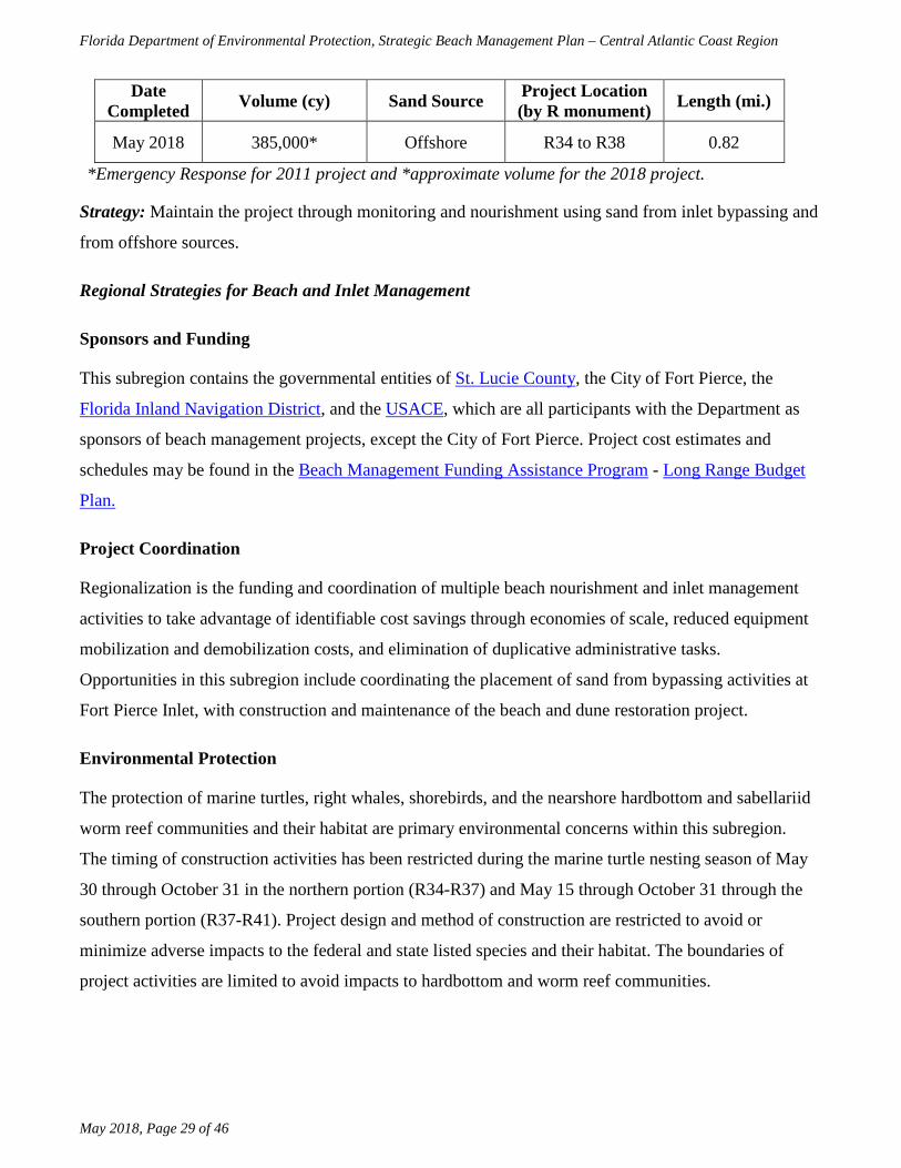
Florida Department of Environmental Protection, Strategic Beach Management Plan – Central Atlantic Coast Region
May 2018, Page 29 of 46
Date Completed Volume (cy) Sand Source Project Location
(by R monument) Length (mi.)
May 2018 385,000* Offshore R34 to R38 0.82
*Emergency Response for 2011 project and *approximate volume for the 2018 project.
Strategy: Maintain the project through monitoring and nourishment using sand from inlet bypassing and
from offshore sources.
Regional Strategies for Beach and Inlet Management
Sponsors and Funding
This subregion contains the governmental entities of St. Lucie County, the City of Fort Pierce, the
Florida Inland Navigation District, and the USACE, which are all participants with the Department as
sponsors of beach management projects, except the City of Fort Pierce. Project cost estimates and
schedules may be found in the Beach Management Funding Assistance Program - Long Range Budget
Plan.
Project Coordination
Regionalization is the funding and coordination of multiple beach nourishment and inlet management
activities to take advantage of identifiable cost savings through economies of scale, reduced equipment
mobilization and demobilization costs, and elimination of duplicative administrative tasks.
Opportunities in this subregion include coordinating the placement of sand from bypassing activities at
Fort Pierce Inlet, with construction and maintenance of the beach and dune restoration project.
Environmental Protection
The protection of marine turtles, right whales, shorebirds, and the nearshore hardbottom and sabellariid
worm reef communities and their habitat are primary environmental concerns within this subregion.
The timing of construction activities has been restricted during the marine turtle nesting season of May
30 through October 31 in the northern portion (R34-R37) and May 15 through October 31 through the
southern portion (R37-R41). Project design and method of construction are restricted to avoid or
minimize adverse impacts to the federal and state listed species and their habitat. The boundaries of
project activities are limited to avoid impacts to hardbottom and worm reef communities.

Florida Department of Environmental Protection, Strategic Beach Management Plan – Central Atlantic Coast Region
May 2018, Page 30 of 46
Sand Sources
During planning and design of the Fort Pierce Shore Protection Project, a sufficient quantity of sand for
completion of initial restoration and nourishment for the next 15 years was identified in Capron Shoal.
A regional sediment management strategy that uses beach quality sand from upland dredged material
management areas and the maintenance dredging of the navigation project should be incorporated into
the maintenance of the beach restoration project. Since there are limited sand resources existing in state
waters in Southeast Florida, the Department and the USACE completed the Sediment Assessment and
Needs Determination (SAND) study. This study was conducted in a collaborative manner, and was
reviewed by and vetted through all the participating stakeholders. The SAND study indicates that the
regional offshore supply of sand in state and federal waters is more than adequate to meet the needs of
all the beach nourishment projects in the five southeastern coastal counties (St. Lucie, Martin, Palm
Beach, Broward, and Miami-Dade) for the next 50 years (year 2062), according to Ousley et al. (2014).
Subsequently, the Department analyzed the need for sand over the next 10 to 20 years for the five
southeastern counties, and determined that approximately 20 to 30 million cy will be needed for beach
nourishment projects. Due to the narrow continental shelf adjacent to Florida’s southeastern shoreline, it
is expected that some counties may need to look for sand resources in upland sand mines and/or offshore
borrow sites in neighboring counties; Miami-Dade County has already initiated this process.
Coordination is recommended between the Department, the USACE, BOEM and local governments to
use best management practices with these offshore resources. For additional information on sand
sources, the Department manages the Regional Offshore Sand Source Inventory (ROSSI) database.
Additional Information
The introduction of the state’s Strategic Beach Management Plan provides additional background
information on the Department’s Beach Management Programs and includes overviews of:
• The principals and statutes followed to help guide the state’s management strategies
• Comprehensive list of Florida’s inlets
• The miles of critically eroded beaches under active management
• Statewide sand source studies
• Statewide monitoring programs
• Innovative technologies examined

Florida Department of Environmental Protection, Strategic Beach Management Plan – Central Atlantic Coast Region
May 2018, Page 31 of 46
• Basic suggestions for emergency response plans

Florida Department of Environmental Protection, Strategic Beach Management Plan – Central Atlantic Coast Region
May 2018, Page 32 of 46
Figure 3. Map of St. Lucie County beaches. View an interactive map or COASTS imagery.

Florida Department of Environmental Protection, Strategic Beach Management Plan – Central Atlantic Coast Region
May 2018, Page 33 of 46
References
Balsillie, J. H., 1985. Post-Storm Report: the Florida East Coast Thanksgiving Holiday Storm of 21-24
November 1984, Florida Department of Natural Resources, Division of Beaches and Shores,
Post-Storm Report No. 85-1, 74 p.
Clark, R.R., LaGrone, J.W., and Koch, J.L, 2006. Hurricane Wilma: Post-Storm Beach Conditions and
Coastal Impact Report, Florida Department of Environmental Protection, Bureau of Beaches and
Coastal Systems, 98 p.
Clark, R.R., LaGrone, J.W., Brantly, R.., 2004. Hurricane Frances & Hurricane Jeanne: Post-Storm
Beach Conditions and Coastal Impact Report with Recommendations for Recovery and
Modifications of Beach Management Strategies, Florida Department of Environmental
Protection, Bureau of Beaches and Coastal Systems, 93 p.
Clark, R.R., 2000. The Impact of Hurricanes Floyd and Irene on the Florida East Coast, Florida
Department of Environmental Protection, Bureau of Beaches and Coastal Systems, Report No.
00-01, 55 p.
Coastal Planning and Engineering, Inc., 1997. Fort Pierce Inlet Management Plan, 190 p.
Coastal Technology Corporation, 1996a. Phase II – Plans and Specifications Level Report, Ft Pierce,
Florida, Shore Protection Project, Geotechnical and Borrow Area Investigation.
Coastal Technology Corporation, 1996b. Spur Jetty Design Memorandum: Ft Pierce, Florida.
Coastal Technology Corporation, 1995. Phase I – Reconnaissance Level, Ft Pierce, Florida, Shore
Protection Project, Geotechnical and Borrow Area Investigation.
Florida Department of Environmental Protection. 2004 Hurricane Recovery Plan for Florida’s Beach
and Dune System, 65 p.
Florida Department of Environmental Protection, 2017. Critically Eroded Beaches in Florida, Division
of Water Resource Management, 89 p.
Florida Department of Environmental Protection, 1997. Ft Pierce Inlet Management Study
Implementation Plan, 9 p.

Florida Department of Environmental Protection, Strategic Beach Management Plan – Central Atlantic Coast Region
May 2018, Page 34 of 46
Ousley, J.D., Kromhout, E., Schrader, M.H., Lillycrop, L., 2014. Southeast Florida sediment assessment
and needs determination (SAND) study, Final Report, ERDC/CHL TR-14-10, U.S. Army Corps
of Engineers, 321 p.
Srinivas, R. and Heckman, L.D., 2002. Ft Pierce Beach Renourishment, St. Lucie County, Florida: Two-
Year Post-Fill Monitoring Report, Taylor Engineering, Inc.
Taylor Engineering, Inc., 2011. Ft Pierce Shore Protection Project,2011 Two Year Post Construction
Monitoring Report, St. Lucie County, Florida, 5 p.
Taylor Engineering, Inc., 2004. Ft Pierce Inlet Sand Bypassing Feasibility Study, St. Lucie County,
Florida, 151 p.
Taylor Engineering, Inc., 2003. Ft Pierce Shore Protection Project Design Documentation Report, 166
p.
Taylor Engineering, Inc., 2001. Coastal and Inlet Processes Evaluation: Ft Pierce Inlet and Adjacent
Beaches, 215 p.
U.S. Army Corps of Engineers, 1998. Water Resources Development in Florida.
U.S. Army Corps of Engineers, 1995. Fort Pierce, Florida, Shore Protection Project, Reevaluation
Report, Section 934 Study with Environmental Assessment, Jacksonville District, August 1993
(revised May 1995).
U.S. Army Corps of Engineers, 1978. Fort Pierce, Beach Erosion Control Project, General and Detail
Design Memorandum, Jacksonville District.
U.S. Army Corps of Engineers, 2000. Fort Pierce Shore Protection Project, St. Lucie County, Florida,
General Reevaluation Report with Draft Environmental Assessment, Jacksonville District, April
1998 (Revised 2000).
U.S. Army Corps of Engineers, 2002. Final Environmental Impact Statement: Future Dredging of
Capron Shoal for the Fort Pierce Shore Protection Project St. Lucie County, Florida.

Florida Department of Environmental Protection, Strategic Beach Management Plan – Central Atlantic Coast Region
May 2018, Page 35 of 46
Treasure Coast
There are 27.8 miles of beaches in the Treasure Coast subregion, which extends from R80 in St. Lucie
County to the Martin–Palm Beach County line, as shown on Figure 4. There are 23.3 miles of critically
eroded beaches in this subregion, of which 14.9 have been restored and maintained.
Erosion is attributed to frequent northeasters, occasional tropical storms and hurricanes, and the effects
of St. Lucie Inlet. The most erosive storms occurring in recent past years were Hurricane David (1979),
the Thanksgiving Day Northeaster of 1984, Hurricane Irene (1999), Hurricane Frances (2004), and
Hurricane Jeanne (2004), Hurricane Wilma (2005), Subtropical Storm Andrea (2007), October
northeasters (2007), and Tropical Storm Noel (2007), Tropical Storm Fay (2008), Hurricane Sandy
(2012), Hurricane Matthew (2016) and Hurricane Irma (2017).
Strategies for Inlets and Critically Eroded Beaches
Walton Rocks, St. Lucie County, R80-R90.3
This segment includes 1.9 miles of critically eroded beaches on Hutchinson Island in southern St. Lucie
County, where the St. Lucie Nuclear Power Plant facilities, Walton Rocks County Park, and private
condominium developments are located. This segment is predominantly within the U.S. Fish and
Wildlife Service – Coastal Barrier Resources Act – Unit P11, in which the Power Plant Facilities and the
Sand Dollar Shores and Dune Walk Condominiums are excluded. This area was severely impacted by
Hurricanes Frances and Jeanne (2004). In 2004, the U.S Army Corps of Engineers initiated a feasibility
study to evaluate a beach restoration project from R77 to just south of R115 (the Martin County line). In
2007, dune restoration was conducted from R88 to R90. In 2012, at the St. Lucie Nuclear Power Plant
facilities, a steel sheet-pile seawall along 350 ft. of coast at R81 was constructed to protect the nuclear
power plant’s cooling water intake canal.
Strategy: Maintain the dune restoration.
South St. Lucie County Beaches, St. Lucie County, R98-R115+1000 (County Line)
This is a 3.4-mile segment of critically eroded beach on Hutchinson Island in southern St. Lucie County
along private residential condominium developments. This area was severely impacted by Hurricane
Irene (1999) and Hurricanes Frances and Jeanne (2004). In 2004, the USACE initiated a feasibility
study, which encompasses R77 to just south of R115 (the Martin County line). An Environmental
Impact Statement and sand search were completed by the County in conjunction with the planning and

Florida Department of Environmental Protection, Strategic Beach Management Plan – Central Atlantic Coast Region
May 2018, Page 36 of 46
design for a non-federal project on South St. Lucie County Beaches, completed in 2013. The county
identified the St. Lucie Shoal as a sand source for the 2013 non-federal restoration project area and any
future federal projects. Work by St. Lucie County was applied as a credit against an ongoing federal
feasibility study for the proposed future federal project. In 2005 and 2006, an emergency dune
restoration project was constructed from R97.7 to R114, using 160,000 cy of sand. The dune project was
impacted by the passage of Hurricane Sandy shortly before the full beach restoration project was
scheduled to begin, so storm repairs were designed to be completed in conjunction with the restoration.
Restoration was completed in May 2013 between R98 through R115 + 1000 (County Line), with
635,164 cy of sandy material from an offshore borrow site placed along 3.4 miles of critically eroded
beach. Construction of a 1.89-acre mitigation reef was initiated in 2013 to mitigate for hardbottom
impacts. Construction of the mitigation reef was completed in 2015. The project has a ten-year
nourishment interval, and the next nourishment is expected to occur by 2023 as a federal project. St.
Lucie County is seeking to pursue a federally authorized project for this segment of shoreline, in
coordination with the federally authorized Martin County Shore Protection Project just south of the
South St. Lucie Project area. The USACE completed the Draft Integrated Feasibility Study and
Environmental Assessment in April 2016 of St. Lucie County’s southern 7.4-mile shoreline between
R77 and R115/ County Line. The study will determine the final alternatives or tentatively selected plan
(TSP) for the project area and is scheduled for final approval by summer 2017.
Strategy: Maintain and monitor the beach restoration project.
Hutchinson Island, Martin County, R1-R34.3
This is a 5.7-mile segment of critically eroded beach along southern Hutchinson Island fronting private
residential development and county beach access parks. The federal Martin County Shore Protection
Project provides for beach restoration and periodic nourishment along the northernmost 4.2 miles of the
county shoreline (R1-R23). The local sponsor is Martin County. The federal project design consists of a
beach berm at elevation +8.0 ft NGVD to protect the existing dune and upland development, and the
project history for this segment of shoreline is described in Table 6. The project is authorized until 2046.
Beach restoration was completed in April 1996, including an extension of the beach fill from R23 to
R25 as a non-federal (locally preferred) project feature.

Florida Department of Environmental Protection, Strategic Beach Management Plan – Central Atlantic Coast Region
May 2018, Page 37 of 46
South of the federal project template, this critically eroded area was severely impacted by Hurricanes
Frances and Jeanne (2004), as the eye of both storms made landfall near the House of Refuge (R29.5).
From R25 to R26, emergency protective berms were constructed using funds from FEMA. A dune
restoration project with vegetation was constructed in 2005 to supplement the emergency protective
berms funded by FEMA, with approximately 94,000 cy of upland sand by way of a truck haul between
R25 and R34. Hutchinson Island beaches were nourishment again with approximately 400,000 cy of
material from an offshore borrow site and completion of the project was in April 2018.
Table 6. Martin County Shore Protection Project history.
Date Completed Volume (cy) Sand Source Project Location
(by R monument) Length (mi.)
April 1996 1,340,000 Offshore R1-R25 4
January 2001 178,000 Offshore R16.2-R22.3 1.2
February 2002 126,000 Offshore R13.5-R16.2 0.5
April 2005 885,000* Offshore R1-R25.6 4.2
May 2013 613,017 Offshore R1-R25 4.0
April 2018 400,000 Offshore R1-R25 4.0
*This volume combines the beach nourishment (R1–R25.6) and dune restoration volumes (R25 – R25.6). Strategy: Maintain the project through monitoring and nourishment; determine environmentally
acceptable alternatives for beach management for the area between R25 and R34.3.
Bathtub Beach and Sailfish Point, Martin County, R34.3-R40
Bathtub Beach and Sailfish Point (R34.3-R42.3) are south of the federal shore protection project area on
Hutchinson Island, with a 1.0-mile segment (R34.3 to R40) of critically eroded beach at both Bathtub
Beach and Sailfish Point. This critical erosion area added a 0.4-mile segment to their critical erosion
area in 2015, which now reaches down to R40 for design integrity of the beach nourishment project.
Both Bathtub and Sailfish Point encountered severe erosion from the 2004 hurricane season. A total of
approximately 218,600 cy of sand has been placed directly within the study area shoreline (R35-R42)
between December 2004 and February 2012. Bathtub Beach between R34 and R36 has received the
placement of approximately 85,711 cy of sand from 2008 through 2013 by Martin County using an
upland sand source. The county and the community of Sailfish Point obtained a permit in October 2015

Florida Department of Environmental Protection, Strategic Beach Management Plan – Central Atlantic Coast Region
May 2018, Page 38 of 46
to construct a beach nourishment project between R34.3 and R37.8 (Bathtub Beach), and a restoration
project between R37.9 and R40 (Sailfish Point). The beach restoration project was completed in May
2016 and placed 325,400 cy of material on the 1,350-foot segment of Bathtub Beach and the 3,550-foot
segment of Sailfish Point. Due to erosion from Hurricane Matthew, beach nourishment occurred again
and was partially completed in May 2017 between R34.5 to R38 in the amount of 75,500 cy. The
material came from inlet borrow area A and the Sailfish Point Navigation and Entrance Channel for the
2017 activities. Due to erosion from Hurricane Irma, the Bathtub Beach project was completed in April
2018 and placed a total of 140,000 cy between R34.5 and R36.
Strategy: Maintain the project through monitoring and nourishment; bypass material in accordance with
the updated IMP.
St. Lucie Inlet, Martin County, R44-R45
St. Lucie Inlet was originally cut by local interests in 1892, and the inlet federal navigation project has
been maintained since 1916. Between 1980 and 1982, construction of the south dog leg section of the
north jetty, the sand impoundment basin, the detached breakwater south of the channel, and the south
jetty were completed, which essentially established the current configuration of the St. Lucie Inlet.
Following the 1982 improvements, maintenance dredging of the entrance channel was conducted at
approximately four-year intervals, with placement along the one-mile segment of shoreline immediately
south of the inlet. The exception occurred in 1996, when dredged material was placed within a nearshore
disposal area.
The St. Lucie Inlet Management Study Implementation Plan was adopted by the Department in 1995.
Inlet sand bypassing in 1997 included the transfer of beach compatible dredged material from the
FIND's M-5 Dredged Material Management Area and from the adjacent Intracoastal Waterway channels
to the beaches south of the inlet (R59-R65, R75-R82). Sand from a portion of the inlet flood shoal was
transferred to the beaches south of the inlet (R78-R84, R92-R100) within the Town of Jupiter Island in
1999.
The USACE’s St. Lucie Inlet Design Memorandum and Final Environmental Assessment (2000)
identified both navigation and sand bypassing improvements. The project modifications include
elevating the crest height of the north jetty beginning seaward of the weir section and ending at the
southeasterly jetty extension, constructing a modified sediment impoundment basin, and disposing of
maintenance dredge material in the following order of priority: on the beach beginning 5,000 feet south

Florida Department of Environmental Protection, Strategic Beach Management Plan – Central Atlantic Coast Region
May 2018, Page 39 of 46
of the inlet or into the nearshore south of the inlet at a depth of less than -16 feet NGVD. The nearshore
disposal option is normally used in emergency dredging situations. The construction of the sediment
impoundment basin was completed in August of 2002. The north jetty rehabilitation, completed in 2009,
increased the height of the jetty to +8ft MLW. An updated sediment budget for St. Lucie Inlet was
prepared for Martin County in 2014. Several local stakeholders and the Department have reviewed and
analyzed the 2014 sediment budget, with the intent of adopting an updated IMP.
The updated St. Lucie Inlet Management Plan was adopted by the Department in January of 2016, and
provides new strategies and new bypass objectives. A brief summary of the five strategies is listed
below.
Strategy: Continue the existing comprehensive beach and inlet hydrographic monitoring program to
evaluate performance and impact of existing bypassing and nourishment projects, and to update and
define the inlet sediment budget; modify the inlet sand transfer protocol to permit the placement of inlet
dredge material along the Atlantic beaches, both to the north and to the south of the inlet, within
designated critically eroded areas between R34.5 and R111; the initial target bypassing quantities shall
be the average annual placement of 161,000 cubic yards to the south and 34,000 cubic yards to the
north; material excavated from the inlet system, including the sediment impoundment basin, the federal
navigation channel and transition area, the Sailfish Point Marina channel and the inlet’s ebb, flood and
interior shoals, shall generally be the source of sediment for meeting the target bypassing quantities in
Strategy 3; the nearshore placement of inlet dredge material shall generally not be conducted except for
emergency dredging in the federal navigation channel only, and when placed in nearshore water depths
less than -12 feet (MLW).
Jupiter Island, Martin County, R45–R111
This is an 11.5-mile segment of critically eroded beach south of St. Lucie Inlet along Jupiter Island,
which includes the St. Lucie Inlet State Park and the Hobe Sound National Wildlife Refuge (NWF).
The project history for this segment of shoreline is described in Table 7. The non-federal Jupiter Island
Beach Nourishment Project (R75-R117) placed sand along a portion of the Town of Jupiter Island's
shoreline using an offshore borrow source in 1973-74. The project design consists of a beach berm at
elevation +9.9 ft NGVD to protect the existing dune and upland development. Nourishment of discrete
segments of the Town's shoreline using offshore borrow areas was conducted on a three to four-year
basis through 1996. In 1999, the St. Lucie Inlet flood shoal sand transfer project bypassed material to the
Hobe Sound NWR segment of shoreline north of the Town of Jupiter Island. This area has sustained

Florida Department of Environmental Protection, Strategic Beach Management Plan – Central Atlantic Coast Region
May 2018, Page 40 of 46
historic erosion, overwash, and breakthrough threats to the environmentally sensitive Peck’s Lake and
the culturally significant Joseph Reed Mound archeological site. Nourishment was initiated in the spring
of 2006 and completed in 2007, due to damages sustained from the 2004 hurricane season. A summary
of dredging events on Jupiter Island are presented below. Due to Hurricane Matthew (2016), the Town
has received a grant from FEMA to assist with the next planned nourishment event in 2019/2020.
Table 7. Jupiter Island Beach Nourishment Project history.
Date Completed Volume (cy) Sand Source Project Location
(by R monument) Length
(mi.)
1973-1974 3,488,759 Nearshore borrow area R82-R111 4.9
1977-1978 1,327,289 Nearshore borrow area R87-R110 2.5
1983 1,000,000 Nearshore borrow area R89-R95 and R102-
R106 1.7
1987 2,234,869 Nearshore borrow area
R76-R81 and R87-R100 and R105-
R111 3.1
1990 585,308 Offshore R96-R102 and R106-R111 1.8
1991 414,812 Offshore R77-R81 and R91-R98 1.7
1993 203,736 Offshore R106-R111 0.8
1995-1996 1,741,134 Offshore R76-R105 4.9
2002-2003 1,519,561 Offshore R75-R84 and R88-R113 and Nearshore 5.8
2006-2007 1,706,711 Offshore R76-R84 and R89-R111 5.1
2012 1,150,858 Offshore R76-R84 and R91-R108 4.3
April 2016 1,670,455 Offshore R76-R84 and R91-R113 4.9
Source: Gahagan & Bryant Associates and ATM for year 2016.
Florida Department of Environmental Protection, Strategic Beach Management Plan – Central Atlantic Coast Region
May 2018, Page 41 of 46
Strategy: Maintain the project through monitoring and nourishment; continue inlet sand bypassing in
accordance with the updated IMP.
Regional Strategies for Beach and Inlet Management
Sponsors and Funding
This subregion contains the governmental entities of St. Lucie County, Martin County, the Town of
Jupiter Island, the Florida Inland Navigation District, and the USACE, which are all participants with
the Department as sponsors of beach management projects. St. Lucie Inlet State Park and Hobe Sound
National Wildlife Refuge are located on northern Jupiter Island. Project cost estimates may be found in
the Beach Management Funding Assistance Program - Long Range Budget Plan.
Project Coordination
Regionalization is the funding and coordination of multiple nourishment and inlet management activities
to take advantage of identifiable cost savings through economies of scale, reduced equipment
mobilization and demobilization costs, and elimination of duplicative administrative tasks.
Opportunities in this subregion include potential coordination to provide for future concurrent
nourishment of the South St. Lucie County Beaches with Martin County’s Shore Protection Project that
could provide an opportunity for future cost savings. In addition, coordination of maintenance dredging
activities at St. Lucie Inlet and the Intracoastal Waterway with the inlet sand bypassing activities to
enhance the eroded adjacent beaches and optimize the maintenance of the Jupiter Island beach
restoration project.
Environmental Protection
The protection of marine turtles, right whales, shorebirds, and hardbottom/reef communities and their
habitats are primary environmental concerns within this subregion. Project design and method of
construction are restricted to avoid or minimize adverse impacts to the federal and state listed species
and their habitat. The westward portion of the federal navigation channel at St. Lucie Inlet is surrounded
by the boundaries of the Jensen Beach to Jupiter Inlet Aquatic Preserve. While the federally authorized
navigation channel is not classified as part of the aquatic preserve, projects located within and near the
aquatic preserve boundaries require additional protection, including more stringent water quality
standards than in non-aquatic preserve waters, during permitting and construction to ensure preservation
of the existing conditions.

Florida Department of Environmental Protection, Strategic Beach Management Plan – Central Atlantic Coast Region
May 2018, Page 42 of 46
Sand Sources
The sand source for nourishment of the South St. Lucie County Beach Restoration project has been the
St. Lucie Shoal, located offshore of St. Lucie and Martin County line. The sand source for nourishment
of the federal Martin County Shore Protection project has been the Gilbert Shoal, located offshore of
northern Martin County and the St. Lucie Shoal (borrow area B) offshore of the St. Lucie County/Martin
County Line. Additional borrow area sites A and B are located offshore of Jupiter Island. Since there are
limited sand resources existing in state waters in Southeast Florida, the Department and the USACE
completed the Sediment Assessment and Needs Determination (SAND) study. This study was
conducted in a collaborative manner, and was reviewed by and vetted through all the participating
stakeholders. The SAND study indicates that the regional offshore supply of sand in state and federal
waters is more than adequate to meet the needs of all the beach nourishment projects in the five
southeastern coastal counties (St. Lucie, Martin, Palm Beach, Broward, and Miami-Dade) for the next
50 years (year 2062), according to Ousley et al. (2014). Subsequently, the Department analyzed the need
for sand over the next 10 to 20 years for the five southeastern counties, and determined that
approximately 20 to 30 million cy will be needed for beach nourishment projects. Due to the narrow
continental shelf adjacent to Florida’s southeastern shoreline, it is expected that some counties may need
to look for sand resources in upland sand mines and/or offshore borrow sites in neighboring counties;
Miami-Dade County has already initiated this process.
Coordination is recommended between the Department, the USACE, BOEM, and local governments to
use best management practices with these offshore resources. For additional information on sand
sources, the Department manages a database named the Regional Offshore Sand Source Inventory
(ROSSI).
Additional Information
The introduction of the State’s Strategic Beach Management Plan provides additional background
information on the Department’s Beach Management Programs, and includes overviews of:
• The principals and statutes followed to help guide the state’s management strategies
• Comprehensive list of Florida’s inlets
• The miles of critically eroded beaches under active management
• Statewide sand source studies

Florida Department of Environmental Protection, Strategic Beach Management Plan – Central Atlantic Coast Region
May 2018, Page 43 of 46
• Statewide monitoring programs
• Innovative technologies examined
• Basic suggestions for emergency response plans

Florida Department of Environmental Protection, Strategic Beach Management Plan – Central Atlantic Coast Region
May 2018, Page 44 of 46
Figure 4. Map of the beaches located within the Treasure Coast in St. Lucie and Martin Counties. View an interactive map or COASTS imagery.

Florida Department of Environmental Protection, Strategic Beach Management Plan – Central Atlantic Coast Region
May 2018, Page 45 of 46
References
Applied Technology and Management, Inc., 1998. Martin County Beach Renourishment Project - Project
Performance Report.
Applied Technology and Management, Inc., 1992. St. Lucie Inlet Management Plan.
Balsillie, J. H., 1985. Post-Storm Report: The Florida East Coast Thanksgiving Holiday Storm of 21-24
November 1984, Florida Department of Natural Resources, Division of Beaches and Shores, Post-Storm
Report No. 85-1, 74 p.
Clark, R.R., LaGrone, J.W., and Koch, J.L, 2006. Hurricane Wilma: Post-Storm Beach Conditions and Coastal
Impact Report, Florida Department of Environmental Protection, Bureau of Beaches and Coastal
Systems, 98 p.
Clark, R.R., LaGrone, J.W., Brantly, R.., 2004. Hurricane Frances & Hurricane Jeanne: Post-Storm Beach
Conditions and Coastal Impact Report with Recommendations for Recovery and Modifications of Beach
Management Strategies, Florida Department of Environmental Protection, Bureau of Beaches and
Coastal Systems, 93 p.
Clark, R.R., 2000. The Impact of Hurricanes Floyd and Irene on the Florida East Coast, Florida Department of
Environmental Protection, Bureau of Beaches and Coastal Systems, Report No. 00-01, 55 p.
Coastal Planning and Engineering, Inc., 2002. St. Lucie County, South County Post-Storm Beach Condition
Study – Tasks 3, 4, and52: Future Threats to Existing Development and Solutions to Mitigate Erosion,
64 p.
Coastal Planning and Engineering, Inc., 2001. St. Lucie County, South County Post-Storm Beach Condition
Study – Tasks 1 and 2: Past and Current Erosion Conditions and Changing or Accelerated Erosion
Trends, 123 p.
Coastal Technology Corporation, 1998. Florida Inland Navigation District MSA M-5 Sand Transfer Project 12
Month Monitoring Report.
Finkl, C.W. et al, 2006. South St. Lucie County Hurricane and Storm Damage Reduction Project: 2006
Offshore Geotechnical Investigations to Identify Sand Sources, Coastal Planning and Engineering, Inc.,
636 p.

Florida Department of Environmental Protection, Strategic Beach Management Plan – Central Atlantic Coast Region
May 2018, Page 46 of 46
Florida Department of Environmental Protection. 2004 Hurricane Recovery Plan for Florida’s Beach
and Dune System, 65 p.
Florida Department of Environmental Protection, 2017. Critically Eroded Beaches in Florida, Division of
Water Resource Management, 89 p.
Florida Department of Environmental Protection, 1995. St. Lucie Inlet Management Study Implementation Plan,
August 1995, 8 p.
Florida Department of Environmental Protection, 2016. St. Lucie Inlet Management Plan, January 2016, 8 p.
Howard, B., Bender, C., and Craig, K.R., 2006. Martin County Shore Protection Project, Martin County,
Florida, 2005 Post-Construction Monitoring Report, Taylor Engineering, Inc.
Martin County’s St. Lucie Inlet Advisory Committee, 2014. St. Lucie Inlet: Inlet Management Alternatives
Analysis Report, January 2014, 134 p.
Ousley, J.D., Kromhout, E., Schrader, M.H., Lillycrop, L., 2014. Southeast Florida sediment assessment
and needs determination (SAND) study, Final Report, ERDC/CHL TR-14-10, U.S. Army Corps
of Engineers, 321 p.
U.S. Army Corps of Engineers, 2000. St. Lucie Inlet Design Memorandum and Final Environmental
Assessment, Jacksonville District.
U.S. Army Corps of Engineers, 1998. Water Resources Development in Florida.
U.S. Army Corps of Engineers, 1994. Martin County, Florida, Shore Protection Project, General Design
Memorandum with Environmental Assessment, Jacksonville District.
U.S. Army Corps of Engineers, 2016. St. Lucie County Coastal Storm Risk Management Project - Draft
Integrated Feasibility Study and Environmental Assessment, U.S. Army Corps of Engineers,
Jacksonville District, 218 p.

Florida Department of Environmental Protection, Strategic Beach Management Plan – Central Atlantic Coast Region
May 2018, Page i of iii
Appendix - Acronyms
Acronyms associated with the Florida Department of Environmental Protection’s Strategic Beach Management Plan:
Coastal Associations Acronyms:
• ASBPA – American Shore & Beach Preservation Association
• FSBPA – Florida Shore & Beach Preservation Association
• DCA – Dredging Contractors of America
Federal Agencies Acronyms:
• BOEM – Bureau of Ocean Energy Management
• CBRA – Coastal Barrier Resources Act
• CHL – Coastal and Hydraulics Laboratory
• CIRP – Coastal Inlets Research Program
• CMS – Coastal Modeling System
• CSRM – Coastal Storm Risk Management
• CZMA – Coastal Zone Management Act
• EA – Environmental Assessment
• EIS – Environmental Impact Statement
• ERDC - Engineer Research and Development Center
• FCCE – Flood Control and Coastal Emergency
• FEMA – Federal Emergency Management Agency
• FRF – Field Research Facility
• GRR – General Reevaluation Report
• HSDR – Hurricane and Storm Damage Reduction
• LPP – Locally Preferred Plan
• LRR – Limited Reevaluation Report
• MMP – Marine Minerals Program
• NGVD 29 – National Geodetic Vertical Datum of 1929
• NAVD 88 – National American Vertical Datum of 1988
• NPS – National Park Service
• NWF – National Wildlife Refuge

Florida Department of Environmental Protection, Strategic Beach Management Plan – Central Atlantic Coast Region
May 2018, Page ii of iii
• NEPA – National Environmental Policy Act
• NOAA – National Oceanic and Atmospheric Administration
• NHC – National Hurricane Center
• NWF – National Wildlife Refuge
• ODMDS - Ocean Dredge Material Disposal Site
• OCS – Outer Continental Shelf
• RSM – Regional Sediment Management
• SAJ – South Atlantic District, Jacksonville
• SPP – Shore Protection Project
• SLC – Sea Level Change
• SLR – Sea Level Rise
• TSP – Tentatively Selected Plan
• USACE – United States Army Corps of Engineers • USFWS – United States Fish and Wildlife Service • WRDA – Water Resources Development Act
State Agencies Acronyms:
• AIWW - Atlantic Intracoastal Waterway
• BCS – Beaches and Coastal Systems
• BIP – Beaches, Inlets and Ports Program
• BMA – Beach Management Agreement
• BMFA – Beaches and Mines Funding Assistance Program
• BMP – Best Management Practices
• BSM – Bureau of Survey and Mapping
• CCCL – Coastal Construction Control Line
• COASTS – Collection of Aerials and Shoreline Trends Systems
• DEP – Department of Environmental Protection
• DMMA – Dredge Material Management Area
• DSL – Division of State Lands
• DWRM – Division of Water Resource Management
• ECL – Erosion Control Line
• EOC – Emergency Operation Center

Florida Department of Environmental Protection, Strategic Beach Management Plan – Central Atlantic Coast Region
May 2018, Page iii of iii
• FAC – Florida Administrative Code
• FAR – Florida Administrative Register
• FDEM – Florida Department of Emergency Management
• FDFS – Florida Department of Financial Services
• FDOT – Florida Department of Transportation
• FHCF - Florida Hurricane Catastrophe Fund
• FIND – Florida Inland Navigation District
• FPS – Florida Park Service
• FS – Florida Statutes
• FWC – Florida Wildlife Commission
• IMP – Inlet Management Plan
• IWW – Intracoastal Waterway
• JCP – Joint Coastal Permit
• LABINS – Land Boundary Information System
• LGFR – Local Government Funding Request
• LRBP – Long Range Budget Plans
• MHWL – Mean High Water Line
• MLLW – Mean Lower Low Water
• MLW – Mean Low Water
• MOA – Memorandum of Agreements
• MOU – Memorandum of Understandings
• OCULUS – DEP’s Electronic Document Management System
• OGC – Office of General Counsel
• R – Range or Reference Survey Monument/Survey Marker
• ROSSI – Regional Offshore Sand Source Inventory
• SAND – Sediment Assessment and Needs Determination Study
• SBMP – Strategic Beach Management Plan
• SOP – Standard Operating Procedures
• SOW – Scope of Work
• TAC – Technical Advisory Committee
• TIITF – Trustees of the Internal Improvement Trust Fund
• WCIND – West Coast Inland Navigation District