Embed Size (px)
Citation preview

Social Screening Report: Central Canal Rehabilitation Strategic Cities Development
Project, Kandy City Region
MINISTRY OF MEGAPOLIS AND URBAN DEVELOPMENT Sethsiripaya, Battaramulla

Contents 1. Background ........................................................................................................................................ 3
2. Sub-Project Description .................................................................................................................. 3
1.1 Introduction: Storm Water Drain Rehabilitation .............................................................. 3
1.2 Existing Conditions of Facility ............................................................................................... 3
1.2.1 Scope of Proposed Civil Works ......................................................................................... 5
3. Justification of Project Design and Alternative Analysis ........................................................ 6
3.1 Importance of Proposed Activity ......................................................................................... 6
3.2 No Project Alternative ............................................................................................................. 7
3.3 Alternative with Enhanced Scope of Work ........................................................................ 7
3.4 Resilience to Natural Disasters .............................................................................................. 8
4. Corridor of Impacts .......................................................................................................................... 8
4.1 Impact Area ................................................................................................................................ 8
4.2 Impact Identification and Assessment ................................................................................ 9
4.3 Significant Impacts ................................................................................................................. 13
4.3.1 Impact Mitigation ........................................................................................................... 14
4.3.2 Public Disclosure and Information Dissemination ................................................. 16
4.3.3 Grievance Redress .......................................................................................................... 17
4.4 Socio-Economic Profile ......................................................................................................... 17
4.5 Social Acceptance of Sub-Project ....................................................................................... 18
5. Social Screening Report ................................................................................................................ 20
6. Estimates of Specific Impacts ...................................................................................................... 21
7. Information on Affected Persons ............................................................................................... 21
8. Decision on Categorization .......................................................................................................... 22
Annex 1: Stakeholder Identification and Consultation .......... Error! Bookmark not defined.
Annex 2 Stakeholder Consultations: Issues, Views and Suggestions ... Error! Bookmark not
defined.
Annex 3 Stakeholder Endorsement of Project Implementation ............ Error! Bookmark not
defined.
Annex 4 Minutes of Community Consultations and Participation ....... Error! Bookmark not
defined.
Annex 6 Community Volunteer Coordinators......................... Error! Bookmark not defined.

Annex 7 Pictorial Representation of Social Screening Process .............. Error! Bookmark not
defined.
Tables
Table 1. No. of Households Affected by Floods according to GN Divisions .............................. 4
Table 2. Basic Details of Central Canal Rehabilitation ..................................................................... 5
Table 3. Details of Construction Design .............................................................................................. 5
Table 4. Identified Locations for Machinery Entry to Canal ........................................................... 6
Table 5. Participation in Community Consultations ........................................................................ 9
Table 6. Impact Identification and Assessment .............................................................................. 11
Table 7. Potential Impacts and Proposed Mitigation Measures ................................................. 14
Table 8. Potentially Affected Households and Business Premises along the Central Canal 18
Figures
Figure 1. Site Map of Proposed Activity: Central Canal .................................................................. 4
Figure 2. End Point of Subsurface Tunnel ..................................................... Error! Bookmark not defined.
Figure 3. Open Canal Downstream ............................................................... Error! Bookmark not defined.
Figure 4. Central Canal through City Centre ................................................. Error! Bookmark not defined.
Figure 5. Central Canal along Main Road with Cross Bridges to Business Premises .. Error! Bookmark not
defined.
Figure 6. House to House Visits .................................................................... Error! Bookmark not defined.
Figure 7. Solid Wastes and Polluted Water .................................................. Error! Bookmark not defined.
Figure 8. Kandy Lake and City Buildings ....................................................... Error! Bookmark not defined.
Figure 9. Laundry Service Facility by Canal ................................................... Error! Bookmark not defined.
Figure 10. Open Canal ................................................................................... Error! Bookmark not defined.
Figure 11. Neighborhood Meeting ................................................................ Error! Bookmark not defined.
Figure 12. Neighborhood Meeting ................................................................ Error! Bookmark not defined.
Figure 13. Neighborhood Meeting ................................................................ Error! Bookmark not defined.
Figure 14. Neighborhood Meeting ................................................................ Error! Bookmark not defined.
1. Background Strategic Cities Development Project has been initiated by the Government of Sri Lanka
to respond to some of the current urban problems and the emerging needs of a Middle
Income Country that it aspires to achieve in the medium term whilst addressing the long
term goals of sustainability, inclusion and poverty reduction. The total project cost
amounting to USD 192.08 MN is co-financed by the GOSL with USD 45.08 MN and the
IDA credit facility of USD 147 MN managed by the World Bank (Project ID: P130548).
The above objective is to be materialized through developing a system of competitive
and strategically linked cities of Sri Lanka. This concept of systemic urban development
underscores triggering strategic or purposive linkages between and among the selected
cities towards achieving the stated development outcomes of the project over and above
the physical outputs and thereby contributing to cause or reinforce positive impacts. In
this connections the cities are placed within a framework of City Region instead of
confining interventions to administrative boundaries of the local government authorities
under whose jurisdiction the cities are situated.
2. Sub-Project Description
1.1 Introduction: Storm Water Drain Rehabilitation
Rehabilitation of Central Canal (Meda Ela) has been designed to improve the city’s major
drainage infrastructure and flood control system on the one hand and enhance capacity
of the Kandy Municipal Council to manage and deliver services. It is part of a larger
intervention for drainage improvement involving (a) the rehabilitation of the connected
upper streams (Rajapihilla and Heelpankandura), and (b) the rehabilitation of existing silt
traps (Lower Mahamaya, and Lower Red Culvert) and construction of new silt traps (Upper
Red Culvert, Upper Hilllwood, Upper Mahamaya) which are screened separately.
Under this particular sub-project the following activity has been prioritized:
Rehabilitation of Kandy City Drainage Canal Meda Ela
The sub-project will directly benefit the city population totaling 108,000 including in
particular the population in 10 GN Divisions where the canal goes through, and an
estimated 350,000 commuters. The district’s population of 1.37 Mn would be among the
indirect beneficiaries. The beneficiary population is multi-ethnic and multi-religious.
1.2 Existing Conditions of Facility
The existing drainage system “Meda Ela” (Central Canal) of Kandy City is an open channel
in most places while in some areas it passes through sub-surface tunnels. It is undersized,
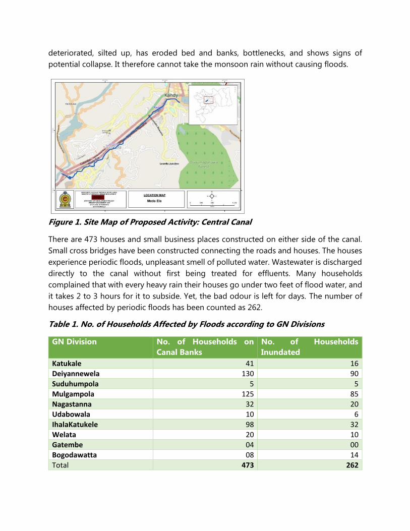
deteriorated, silted up, has eroded bed and banks, bottlenecks, and shows signs of
potential collapse. It therefore cannot take the monsoon rain without causing floods.
Figure 1. Site Map of Proposed Activity: Central Canal
There are 473 houses and small business places constructed on either side of the canal.
Small cross bridges have been constructed connecting the roads and houses. The houses
experience periodic floods, unpleasant smell of polluted water. Wastewater is discharged
directly to the canal without first being treated for effluents. Many households
complained that with every heavy rain their houses go under two feet of flood water, and
it takes 2 to 3 hours for it to subside. Yet, the bad odour is left for days. The number of
houses affected by periodic floods has been counted as 262.
Table 1. No. of Households Affected by Floods according to GN Divisions
GN Division No. of Households on
Canal Banks
No. of Households
Inundated
Katukale 41 16
Deiyannewela 130 90
Suduhumpola 5 5
Mulgampola 125 85
Nagastanna 32 20
Udabowala 10 6
IhalaKatukele 98 32
Welata 20 10
Gatembe 04 00
Bogodawatta 08 14
Total 473 262
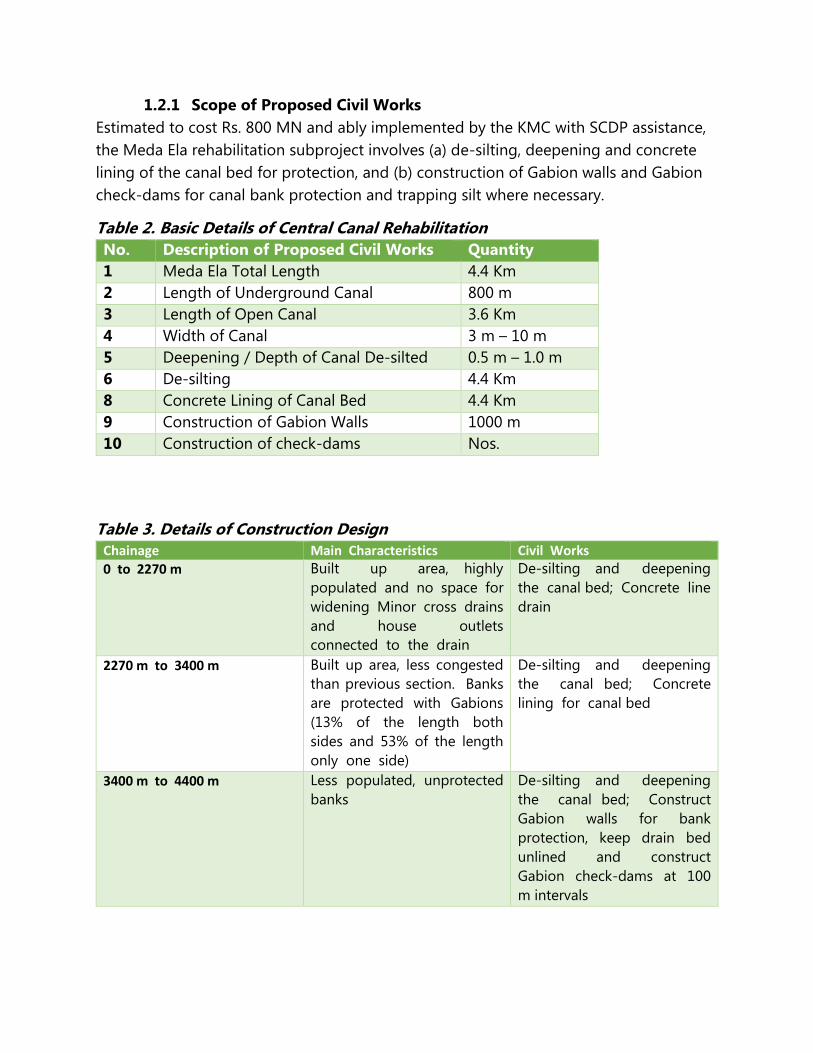
1.2.1 Scope of Proposed Civil Works
Estimated to cost Rs. 800 MN and ably implemented by the KMC with SCDP assistance,
the Meda Ela rehabilitation subproject involves (a) de-silting, deepening and concrete
lining of the canal bed for protection, and (b) construction of Gabion walls and Gabion
check-dams for canal bank protection and trapping silt where necessary.
Table 2. Basic Details of Central Canal Rehabilitation
No. Description of Proposed Civil Works Quantity
1 Meda Ela Total Length 4.4 Km
2 Length of Underground Canal 800 m
3 Length of Open Canal 3.6 Km
4 Width of Canal 3 m – 10 m
5 Deepening / Depth of Canal De-silted 0.5 m – 1.0 m
6 De-silting 4.4 Km
8 Concrete Lining of Canal Bed 4.4 Km
9 Construction of Gabion Walls 1000 m
10 Construction of check-dams Nos.
Table 3. Details of Construction Design Chainage Main Characteristics Civil Works
0 to 2270 m Built up area, highly
populated and no space for
widening Minor cross drains
and house outlets
connected to the drain
De-silting and deepening
the canal bed; Concrete line
drain
2270 m to 3400 m Built up area, less congested
than previous section. Banks
are protected with Gabions
(13% of the length both
sides and 53% of the length
only one side)
De-silting and deepening
the canal bed; Concrete
lining for canal bed
3400 m to 4400 m Less populated, unprotected
banks
De-silting and deepening
the canal bed; Construct
Gabion walls for bank
protection, keep drain bed
unlined and construct
Gabion check-dams at 100
m intervals

Table 4. Identified Locations for Machinery Entry to Canal No. Chain age Location of Machinery Entry
1 280 m Near Goods Shed
2 800 m Near Edmond Silva playground
3 1200 m Near the Laundary at William Gopallawa Mawatha
4 1300 m Near Thennakoon bridge
5 1950 m Near vehicle parking area
6 2450 m Near Heerassagala bridge
7 2960 m Near Lumbini College road
8 3450 m Near Medabowala Bridge
9 4000 m Near UDA land at Gatembe
The proposed activity concerns rehabilitation of an existing facility and does not involve
any new civil works.
This project is not linked to any other activity not funded by SCDP. However, the project
sustainability is enhanced by the implementation of Kandy Wastewater Management
Project in the Municipality that will result in a centralized and modern standard
wastewater collection, treatment and disposal system.
No ancillary impacts or activities away from the sub-project site are anticipated.
The sub-project has a timeline of 18 months for completion, effective 15 January 2016.
Start Date of Construction 15 January 2016
End date of Construction 16 July 2017
3. Justification of Project Design and Alternative Analysis
3.1 Importance of Proposed Activity
The existing drainage system of Kandy City, built over 150 years ago, has been designed
to carry storm water from the city through brick lined underground tunnels to a large
open stream known as Meda Ela that discharges into the Mahaveli River at Getambe.
The Central Canal drainage system is now dilapidated, has failed sections, eroded banks,
and bottlenecks due to unplanned constructions on the banks. In 2013 the tunnel
collapsed in 10 places. Combined with capacity limitations the drainage system cannot
serve the function that it is meant to. Frequent floods during rainy season is common
experience. Many households, business premises, service institutions and industries

discharge wastewater to Meda Ela without first being adequately treated for effluents. The
canal is highly polluted, prone to floods and a potential health hazard. Meda Ela at present
is symbolic of system incompatibilities where unhealthy behaviours and substandard
wastes management practices that contrast the country’s high standards of human and
social development and the noteworthy achievements in economic growth manifest.
3.2 No Project Alternative
The base option of “No Project Alternative” assumes that the City Drainage System will
not be improved at all. Analysis taken under this scenario showed that the citizens will
continue to experience floods that flows into premises mixed with wastewater, damage
to life and property, economic losses due to ill health associated with floods and poor
environmental quality. The urban poor, particularly the women, children and elderly will
continue to face vulnerabilities more than their fair share. The institutional stakeholders,
in particular the KMC, pointed out that it will be under pressure from the public and the
political authorities to respond to service needs which it can hardly meet given the
capacity limitation it is already beset with. Further, the ground realities will be inconsistent
with the public image projected through ‘World Heritage City’ and the ‘Cultural Capital’
of Sri Lanka that attracts Sri Lankans and foreign tourists.
The “No Project Alternative” or “Do Nothing” option essentially serves as a base for
comparison of the benefits and opportunities and savings that the proposed project
would bring through the investment made in drainage improvement. There are many
tangible and intangible costs that the individuals incur in the event of the particular type
of “Meda Ela Floods”. Such costs would be transformed into savings to individuals if the
proposed improvements are carried out. Considering the reality of ‘Climate Change’ the
cost of “Do Nothing Alternative” would be disastrous for the individuals and the society.
Thus, “No Project Alternative” simply means continuing with the present arrangements
without making any extra expenditures to improve the situation.
3.3 Alternative with Enhanced Scope of Work
Under the third alternative the option of undertaking greater scope of work for drainage
improvement was considered. In this respect, the feasibility of widening the canal, further
structural improvements to the banks, walls, widening the flow bends, construction of
more silt traps and reconstruction of Bogambara lake (now a playground) for water
retention were deliberated. Ideas were also expressed regarding taking precautions for
climate changes and rapid urbanization.
It was clear that whatever the positive aspects attributable to widened canals and
tributaries or recreation of old lake, such development can only be at the cost of
demolition of a large number of properties, land acquisitions, compensation and

resettlement. It was abundantly clear that the “Greater Scope Alternative” would be too
costly to bear in a project that is pilot intervention. On the other hand, it would prevent
other cities from being included within SCDP.
3.4 Resilience to Natural Disasters
Resilience to natural disasters of the sub-project is ensured by the adoption of best
engineering practices guaranteeing quality of all constructions and the inclusion of other
connected systems such as upstream rehabilitation, redesigning the existing silt traps and
construction of additional silt traps with better facilities for de-silting, diverting the
overflows from Dunumandalawa reservoir. Re-greening the canal mouth and the area
near Getambe will reinforce natural stability to withstand the effects of floods.
After considering the three alternatives it has been decided to implement
Alternative 1 that recommends implementation of the proposed project,
4. Corridor of Impacts
The approach adopted for identification and assessment of impacts considered the Core
Impact Area (CIA) that is the existing drainage pathway, the Indirect Impact Area (IIA) or
the area adjacent to the CIA and the Area of Influence (AI) constituted by the indirectly
impacted area beyond the CIA and IIA taken together.
4.1 Impact Area
The Core Impact Area is the pathway of the canal including the banks and the
underground tunnels. The canal originates from the overflow sluice of the Kandy Lake,
runs through the densely populated area that consists of residential, commercial and
industrial entities down Wiliam Gopallawa Mawatha, drawing inflows from a number of
tributaries along the way before discharging into the Mahaveli River at Getambe.
The Indirect Impact Area (IIA) is the area that is adjacent to the DIA. Although it is a tiny
stretch confined to the canal banks there are residential and commercial facilities built up
in this area. It should be noted that this SSR does not deal with the impact areas in the
‘Area of Influence’ such as the sites for labour camps have not been finalized as yet. This
would be the responsibility of the contractor.
It is worth mentioning, however, that the community and the stakeholders have
suggested taking advantage of the existing local labour would significantly reduce the
need for erecting labour camps.
The impact area covers the space along the canal pathway 10 m to 15 m wide.

4.2 Impact Identification and Assessment
In the process of screening to identify and assess impacts, steps are taken to list out (a)
the potentially positive and negative impacts, (b) determine the magnitude, extent and
size of impacts, and (c) ascertain the relative significance of the predicted impacts.
Consultative, participatory and transparent procedures were adopted for social screening.
Both qualitative and quantitative analyses were undertaken. The first step taken was to
inform and consult the highest administrative, political and religious authorities in the
district and the province. Key stakeholders were involved to obtain their views and
concerns over the sub-project concerned. Seven levels of stakeholders (See, Annex 1 for
details) were engaged in this process:
1. National Level Buddhist Sects
2. National Level Government Institutions and Political Authorities
3. Provincial Level Government Institutions and Political Authorities
4. District level Government Institutions
5. Divisional Level Government Institutions
6. Ward Level Political Authorities
7. Field Level Officers
Following the key stakeholder endorsement of the project (Annex 2), the PMU, Kandy
Office commenced the consultations at the field level and community level. The
community consultations took place in small groups organized at places such as
community halls convenient to the community and at the individual household level.
House to house visits were also undertaken. In all, nearly 296 persons representing the
community of PAPs in nine GN Divisions engaged in the consultation process.
Table 5. Participation in Community Consultations
S. No. GN Division No. of Males No. of Females Total No. of
Participants
1 Nagasthenna 2 0 2
2 Deiyannewela 92 34 126
3 Suduhumpala East 32 12 44
4 Wel Ata 45 7 52
5 Mulgampala 21 7 28
6 Katukele West 5 1 6
7 Ihala Katukele 23 4 27
8 Bowala 5 5 10
9 Meda Bowala 0 1 1
Total 225 71 296

Minutes of community consultations including the lists of attendance are annexed to this
report (Annex 3).
Some of the major issues and concerns which were discussed included the following:
Previous development projects promised compensation but were never honoured.
Will it be repeated?
What will be the fate of those whose properties would be demolished or acquired?
When will construction begin and end? All starting at the same time? Some areas
prioritized? If so, on what basis?
Will there be impact on houses due to vibrations of machinery and dredging?
Some houses, retaining walls have suffered flood damages but survived with
cracks. Will they be worsened?
Some structures are ‘anawasara’ land (no title deeds of ownership. Are they entitled
for any benefits?
What if the cross bridges are damaged by contractors’ machinery?
Occasionally KMC repaired and de-silted the canal. People were never consulted.
Why only this time? Is there a secret plan to evict unauthorized occupants?
Some land and structures in Kandy belong to the temples. Users are only tenants.
Do they have rights?
In case of service failures, who takes responsibility for restoration?
Will there be work available for the local community in construction work?
How much money will be spent on this project?
Many households and business premises have connected sewers and wastewater
lines to the canal or the linked drains. Canal rehabilitation alone will not benefit
people.
Construction programme will be affected by rain, and women, elderly and children
will be exposed to risks and dangers especially in certain sensitive areas
The impacts identified by the community and their assessment obtained during
consultations are summarized in the Table 6.

Table 6. Impact Identification and Assessment
Item of Impact Construction Period Anticipated Impact Remarks
Core Impact
Area
Indirect Impact
Area
Land Acquisition + - Small section of wall affected due to canal widening to increase curvature of canal path
Owner agreed to move business area interior and continue business and rebuilt the wall on concrete slab; Negligible extent; On canal reservation encroached
Land Instability - - No construction in unstable land; Re-greening downstream canal and river banks part of the design
Land Settlement - - No physical relocation of people
Structure Loss - + Due to increasing curvature of canal path
Owner / occupier agreed with mitigation measure
Infrastructure - + Public utilities (water supply, sewerage, underground telecommunication lines) might be damaged
Slim possibility because construction activities take place away from these facilities
Agriculture - - No agriculture area impacted
Agro-forestry - - No agro-forestry area impacted
Fishing - - No fishing in canal
Mining - - No sand mining in canal
Trade & Commerce - - No impact anticipated as access roads are impacted

Culture & Archaeology
- - No impact on cultural and archaeological sites anticipated
Noise, Vibration, Dust
- ++ Anticipated on transportation routes and construction sites
Recreation & Touristic Activities
- - Construction activities from touristic activity areas
Transportation, Vehicle parking places, Roads, lanes, Cross bridges
- +++ Traffic congestion, Increased risk of accidents, Interruption of service, Access to houses and business premises may be affected, Machinery may damage cross bridges
William Gopallawa Mawatha will be used for construction vehicles for transportation and parking; Goods Shed Bus Stand will face consequent traffic
Public Health & HIV - + + Inflow of workers may cause infectious disease
Public Security + + + Inflow of workers may endanger public security
Worker behaviours and practices may not be acceptable to the community
Public Safety + + Low quality construction may not withstand floods and structures may collapse; Dredging may lead retaining walls to collapse
Muck disposal site - + Removed materials from tunnels and sediments from canal bed may be dumped in environmentally sensitive areas
In the past the KMC has repaired collapsed sections and removed silt from the canal
Code: +++ Major Impact; ++ Moderate Impact; + Minor Impact; - No Impact

4.3 Significant Impacts
(i) Improved Quality of Public Health
The implementation of the sub-project will lead to positive health outcomes and impacts
due to effective control of seasonal floods flowing into residential and business premises
mixed with wastewater and polluted water resulting from the rehabilitation of the central
canal including improvements to the canal bed, banks and related infrastructure. About
110 residential facilities would be relieved of risk of flood events. Additionally, 61 out of
152 houses located at an elevation than the canal will benefit from reduced flood level.
Quality of mental health of the population will improve due to the enhanced aesthetic
value of the city landscape beautifully merged with the city’s drainage system. Quality of
life will be improved for both the city residents, commuters and visitors including pilgrims.
(ii) Improved Property Safety and Sustainability of Drainage Infrastructure
Rehabilitation of Central Canal improves the carrying capacity and serves the southern
city community in Kandy by way of relieving threats to private and public property from
storm water induced floods and impairment of underground tunnels and open area
banks. With the bottlenecks removed and the flow movement facilitated in addition to
having more silt traps in place solid wastes accumulation is unlikely thus contributing to
safety of structures and clean environment. Further, soil erosion will be contained by the
planting appropriate species such as bamboo trees in the embankment where the canal
meets the river.
(iii) Risks to Public Safety
Although there is no land acquisition, resettlement or livelihood impairment, during the
period of construction the public will be inconvenienced by dust, noise, disturbances,
interruption of vehicular movement, traffic congestions etc. These are detailed in the
impact mitigation schedule.
(iv) Loss of Land / Livelihood
A tiny stretch of land on which a temporary structure of 6’ x 5’ has been erected next to
the retaining wall is required to reduce the sharpness of the canal bend at chainage 990
m. Natha Devalaya as the land owner has no objection for the proposed development.
However, the user who erected the structure will be affected, although it is an illegal
construction, and not presently functional unlike previously when he sold fruits from
there. To enable rebuilding the temporary structure the PMU has agreed to extend the
slab to cover the area so he has the option of rebuilding.

Considering the occurrence of a disputed land / structure at 1870 m, the original design
was revised to exclude the structure without compromising on quality of proposed
development activity.
4.3.1 Impact Mitigation
Pursuant to the adoption of Social Management Framework that sets out the principles,
guidelines and procedure for identification and assessment of potential social impacts
and risks, and prepare mitigation plans as appropriate for different sub-projects, the PMU
arranged for awareness creation targeting the primary and secondary stakeholders to
prepare the mindset and ensure broad community support in favour of the proposed
interventions including for social screening and potential impact assessment. The idea
was to eventually prepare social management action plans with gender dimension
mainstreamed to mitigate impacts with inputs from the Project Affected Community and
institutional stakeholders.
Adoption of the above process resulted in the identification of impact locations, direct
and indirect impacts as well as temporary and permanent impacts in a general sense
because specific and finalized engineering designs were not available at the time. The
community will be educated on these specifics at a subsequent stage. However, in terms
of nature of impacts some of them belonged to adverse or negative effects and impacts
while others found membership in the positive or beneficial set of impacts. The latter
category was in the majority. These are detailed in this Social Screening Report (SSR) that
will be disclosed to the public in due course. For the present the following mitigation
measures that resulted from the consultations are furnished.
Table 7. Potential Impacts and Proposed Mitigation Measures
Item of Impact Anticipated Impact
Proposed Mitigation Measure
Responsibility
Structure Loss Due to increasing curvature of canal path section of structure partially affected
Erect extended concrete slab over the bank protection wall so the owner loses no floor area and has a more dependable base on which to build a wall
Contractor under supervision of the project engineer
Infrastructure Public utilities (water supply, sewerage,
Discuss with KMC, NWSDB, Telecom regarding obtaining
Project Director to introduce the contractors to
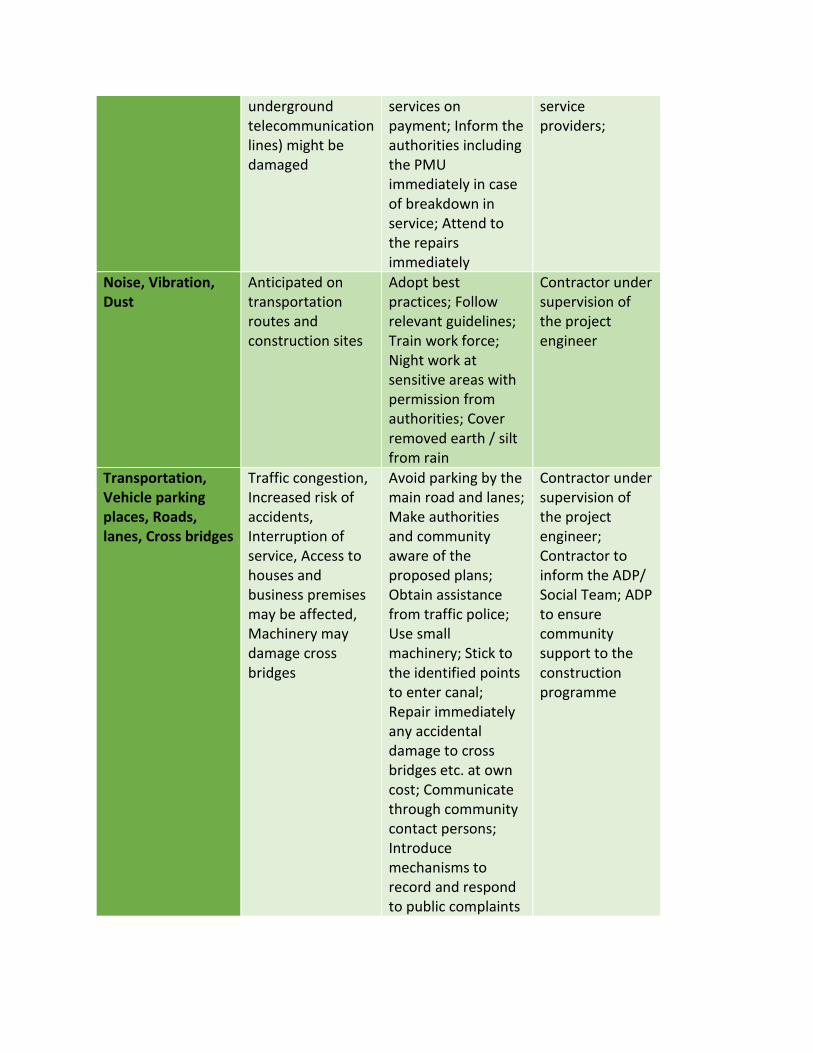
underground telecommunication lines) might be damaged
services on payment; Inform the authorities including the PMU immediately in case of breakdown in service; Attend to the repairs immediately
service providers;
Noise, Vibration, Dust
Anticipated on transportation routes and construction sites
Adopt best practices; Follow relevant guidelines; Train work force; Night work at sensitive areas with permission from authorities; Cover removed earth / silt from rain
Contractor under supervision of the project engineer
Transportation, Vehicle parking places, Roads, lanes, Cross bridges
Traffic congestion, Increased risk of accidents, Interruption of service, Access to houses and business premises may be affected, Machinery may damage cross bridges
Avoid parking by the main road and lanes; Make authorities and community aware of the proposed plans; Obtain assistance from traffic police; Use small machinery; Stick to the identified points to enter canal; Repair immediately any accidental damage to cross bridges etc. at own cost; Communicate through community contact persons; Introduce mechanisms to record and respond to public complaints
Contractor under supervision of the project engineer; Contractor to inform the ADP/ Social Team; ADP to ensure community support to the construction programme

Public Health & HIV Inflow of workers may cause infectious disease
Conduct awareness and train on basic PR; Issue guideline
Contractor with support from KMC health authorities
Public Security Inflow of workers may endanger public security
Conduct awareness with resource persons from the police department; Register workers of all categories with the authorities; Issue guidelines
Contractor with support from AD/Social and Police Department
Public Safety Low quality construction may not withstand floods and structures may collapse; Dredging may lead retaining walls to collapse
Adopt best practices Contractor under supervision of Project Engineer
Muck disposal site Removed materials from tunnels and sediments from canal bed may be dumped in environmentally sensitive areas
Dump only at the particular locations identified by the KMC / CEA
Contractor under supervision of Project Engineer
In the meanwhile, the PMU will prepare a schedule of activities in respect of mitigation of
adverse social impacts based on the SSR that will be treated as an essential part of the
Contracts to be entered with the service providers.
4.3.2 Public Disclosure and Information Dissemination
Disclosure of information and maintenance of transparency is a cardinal principle of the
SCDP governance ideology, the National Involuntary Resettlement Policy and the World
Bank Resettlement Policy Framework. The main social significance of the Information
Disclosure Policy is that when the Project Authorities maintain transparency in project
implementation it produces mutual trust outcomes between the PAPs and the
Stakeholders. Problems that occur in the implementation process can thereby be
effectively and efficiently resolved and implementation delays circumvented. It
contributes to local ownership of externally initiated projects as well as convergence by

the time the project is concluded and commissioned. SCDP is taking every step to disclose
information to the public. SSR, once complete, will be public document containing
accurate, updated and reliable information
4.3.3 Grievance Redress
Though all signs are positive in terms of social soundness of the project, the PAPs may
raise questions of eligibility and entitlements. It is extremely important to address such
grievances in a timely and transparent manner to ensure smooth implementation of the
sub-project. An institutional mechanism with step by step procedures has been identified
and will be streamlined in due course.
The proposed GRM comprises of a representative from KMC, respective Grama
Niladaries, PAP community representatives, contractor’s engineer, Social Officer and
APD/Social from the SCDP. It would meet every two weeks, or more frequently if
needed.
4.4 Socio-Economic Profile
The total number of resident households located on either side of Meda Ela is about 473
with a total population of 1650. These households are connected to the public
administration system of the government through 10 Grama Niladhari (GN) divisions,
under the authority of the Gangawatakorale Divisional Secretariat Division. The relevant
GN Divisions include: Bogodawatta, Medabowala, Welata, Katukale, Deiyannewela,
Suduhumpola, Mulgampola, Nagastanna, Udabowala and Gatambe.
The socio economic profile of the impact area represent three main ethnic groups;
Sinhala, Muslim and Tamil. The upper portion of the canal is heavily populated
with residential and commercial establishments, varying in scale. Some of the big
names whose premises extend up to the canal bank include: Cargills Food City, Royal Mall,
and, Queens Hotel. There is also a Laundry Service Facility that cleans Base Hospital linen
where at least 20 workers are employed. Livelihoods of the residents are closely linked
with the day to day affairs of the city hub where mobile vendors, hiring labor and
most of the young girls are employed in the business centers of the area. On
average, the monthly income of a household is said to range from Rs. 30,000 to Rs.
100,000.
Government institutions adjacent to the canal are many, and include the Railway
Department, Postal Department, Sri Lanka Telecom, Ceylon Electricity Board, Ceylon
Transport Board, Kandy Municipal Council, District Courts Complex, Kandy Hospital

wastewater treatment plant , Buildings Department, Department of Social Services and
the Police Department.
Various types of structures such as dwelling units, commercial and services establishments
and other structures located on or either side of the canal. Wastewater generated from
small scale industries such as commercial laundries, textile dyeing operations, various
workshops, medical service institutions including some hospitals, channeled centres and
laboratories, and auto service centres is generally discharged to the canal without proper
treatment.
Table 8. Potentially Affected Households and Business Premises along the Central Canal GN Division No. of Resident
Households on
Canal Banks
No. of Business
Premises on Canal
Banks
Total No. of
Structures
Katukale 41 25 66
Deiyannewela 130 0 130
Suduhumpola 5 0 05
Mulgampola 125 0 125
Nagastanna 32 12 44
Udabowala 10 0 10
IhalaKatukele 98 0 98
Welata 20 0 20
Gatembe 04 05 09
Bogodawatta 08 03 11 Total 473 45 518
4.5 Social Acceptance of Sub-Project
Through a Social Screening Form developed for screening out the proposed sub-project
the PMU staff identified the potential negative and positive impacts attributable to the
implementation of Central Canal Rehabilitation including the rehabilitation of the two
upstream rivulets and the existing silt traps and the construction of new ones. The PMU
Social Development Team together with the project technical staff members visited the
specific sites – generally assisted by the stakeholder agency officers in the field – to explain
about the details of the construction works planned and the best practices that would be
adopted, in addition to retaining renowned International Service Providers. In these
meetings they discussed with the PAPs about the potential impacts upon the individuals
and the neighbourhood communities including the general public as a result of the
implementation of the proposed development activity. The adoption of the screening
form helped in managing or steering the discussion process including making people
think. At the beginning the people were puzzled because they have not had such

organized meetings or encounters with authorities before. On the other hand, with the
common experience in terms of impacts from seasonal floods mixed with dirt and
polluted wastewater, they could not understand a discourse on the obvious.
It became clear through the process of consultation that the community is eager to
welcoming the sub-project that relieve them of the recurring problems due to floods and
that brings tangible benefits. Further, the proposed activities would take place on the
existing drainage pathways already constructed or are naturally formed. There was neither
land nor property acquisition, resettlement, nor archaeological sites, artefacts, symbols
affected due to the designed sub-project. There were no households or families rendered
vulnerable by the proposed activity that would require Resettlement Action Plan. The area
has no indigenous people. Apart from temporary disturbances, community livelihoods are
not impacted by the implementation of the sub-project. Therefore, the communities of
the impact area agreed with the implementation of the proposed activity and pledged
cooperation to ensure smooth implementation.
Demonstrated commitment to cooperate with project implementation manifested in the
voluntary action to select community level contact points. The community identified a
group of volunteers to link the PAPs with the project implementers and the service
providers. Personalities – 26 in all – who command social respect were selected by the
communities of Ihala Katukele, Wel Atha, Bowalawatte, Mulgampola, Deyyannewela
(Annex 5). They have assured that there would not be any opposition to the sub-project.
Community expects that the sub-project will offer employment opportunities in the
unskilled category. However, the people are aware that only a limited number of labour
work will be available because most of the work will be undertaken using machinery such
as back-hoe and bulldozers etc.

5. Social Screening Report
Probable Involuntary Resettlement Effects Yes No Not
Known
Details
Will the sub-project include any physical construction
work?
√
Does the sub-project include upgrading or rehabilitation of
existing physical facilities?
√
Is the sub-project likely to cause any damage to or loss of
housing, other assets, resource use?
√
Is the site for chosen for this work free from encumbrances
and is in possession of the government/Municipality?
√
If the site is privately owned, will this be purchased or
obtained through voluntary donation?
√
If the land parcel has to be acquired, is the actual plot size
and ownership status known?
√
Is land for material mobilization or transport for the civil
work available within the existing plot/ Right of Way?
√
Are there any non-titled people who living/doing business
on the proposed site for civil work?
√ 11
Will there be loss of /damage to agricultural lands, standing
crops, trees?
√ 3 Nos.
Will there be loss of incomes and livelihoods? √
Will people permanently or temporarily lose access to
facilities, services, or natural resources?
√2
Does the Urban Local Body have its own procedures for
land acquisition?
√
Are there any previous land acquisitions I under this
subproject?
√
Re any indigenous people affected? √
Whether the affected land/structure owners likely to lose
less than 10% of their land/structure area.
√
If so, are these land / structure owners willing to voluntarily
donate the required land for this sub-project?
Is any temporary impact likely? √
1 One non-functional temporary structure will be affected; Floor area will be restored by extending the slab over the canal to enable reconstruction. Another structure is in dispute between the CGR (owner) and individual squatter. Design revised without affecting the project to exclude this structure 2 Only confined to brief periods when civil works are undertaken in the neighborhood
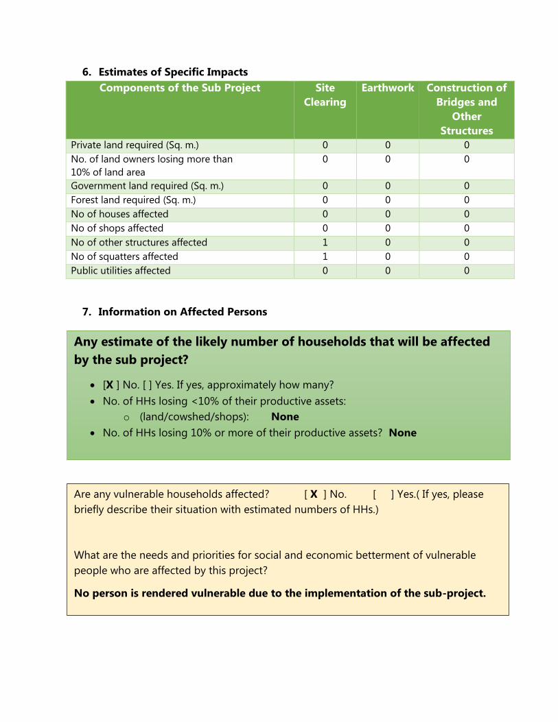
6. Estimates of Specific Impacts
Components of the Sub Project Site
Clearing
Earthwork Construction of
Bridges and
Other
Structures
Private land required (Sq. m.) 0 0 0
No. of land owners losing more than
10% of land area
0 0 0
Government land required (Sq. m.) 0 0 0
Forest land required (Sq. m.) 0 0 0
No of houses affected 0 0 0
No of shops affected 0 0 0
No of other structures affected 1 0 0
No of squatters affected 1 0 0
Public utilities affected 0 0 0
7. Information on Affected Persons
Any estimate of the likely number of households that will be affected
by the sub project?
[X ] No. [ ] Yes. If yes, approximately how many?
No. of HHs losing <10% of their productive assets:
o (land/cowshed/shops): None
No. of HHs losing 10% or more of their productive assets? None
Are any vulnerable households affected? [ X ] No. [ ] Yes.( If yes, please
briefly describe their situation with estimated numbers of HHs.)
What are the needs and priorities for social and economic betterment of vulnerable
people who are affected by this project?
No person is rendered vulnerable due to the implementation of the sub-project.

8. Decision on Categorization
After reviewing the answers above, it is determined that the sub project is:
[ ] Categorized as an ‘A’ project, a full resettlement plan is required
[ ] Categorized as a ‘B’ project, a short resettlement plan is required
[X] Categorized as an ’C’ project, no RP is required, Only Due Diligence Report is
required
Prepared By:
Dr. Gamini Wickramasinghe
(Screening Consultant)
Date: 10th Nov. 2015
Recommended By:
Mr. Pradeep Hettiarachchi
Deputy Project Director / Social, SCDP
Date: 15th Nov. 2015
Approved By:
Archt. Anura Dassanayake
Project Director / SCDP
Date: 15th Nov. 2015