Embed Size (px)
Citation preview
Includes Ordnance Survey Ireland data reproduced under OSi Licence Number AR0077413. Unauthorised reproduction infringes Ordnance Survey Ireland and Government of Ireland copyright. © Ordnance Survey Ireland
STRATEGIC ENVIRONMENTAL ASSESSMENT
SCOPING REPORT
FOR THE
WILD ATLANTIC WAY SIGNATURE TOURISM EXPERIENCE
for: Fáilte Ireland
88-95 Amiens Street
Dublin 1
by: CAAS Ltd.
2nd Floor, The Courtyard,
25 Great Strand Street,
Dublin 1
January 2014
SEA Scoping Report for the Wild Atlantic Way Signature Tourism Experience
CAAS for Fáilte Ireland ii
Table of Contents
Section 1 Introduction and Background ................................................................ 3
1.1 Introduction and Terms of Reference .................................................................................. 3 1.2 The Wild Atlantic Way......................................................................................................... 3 1.3 Progress to Date ................................................................................................................ 5
Section 2 The Assessment Process ........................................................................ 8
2.1 Legislative Context for SEA ................................................................................................. 8 2.2 Appropriate Assessment - A Parallel Assessment .................................................................. 8 2.3 Expected outcomes of the SEA (and AA) .............................................................................. 8 2.4 Consultation with environmental authorities ......................................................................... 9 2.5 What happens next? ........................................................................................................... 9
Section 3 Actions for SEA Best Practice ............................................................... 10
Section 4 Key Scoping Issues .............................................................................. 13
4.1 Legislation and Guidelines ................................................................................................. 13 4.2 Environmental Sensitivities ................................................................................................ 14 4.3 Likely Interactions with Other Plans, Programmes and Projects ........................................... 15 4.4 Strategic Environmental Objectives, Indicators and Targets ................................................ 16 4.5 Potential Environmental Effects ......................................................................................... 16 4.6 Mitigation......................................................................................................................... 17 4.7 Monitoring ....................................................................................................................... 17 4.8 Alternatives ...................................................................................................................... 17
Section 5 Preliminary Identification of Environmental Baseline Content ............ 19
5.1 Introduction ..................................................................................................................... 19 5.2 Biodiversity and Flora and Fauna ....................................................................................... 19 5.3 Population and Human Health ........................................................................................... 23 5.4 Soil .................................................................................................................................. 23 5.5 Water .............................................................................................................................. 25 5.6 Air and Climatic Factors .................................................................................................... 29 5.7 Material Assets ................................................................................................................. 30 5.8 Cultural Heritage .............................................................................................................. 30 5.9 Landscape ....................................................................................................................... 31 5.10 Overlay Mapping of Environmental Sensitivities .................................................................. 33
SEA Scoping Report for the Wild Atlantic Way Signature Tourism Experience
CAAS for Fáilte Ireland 3
Section 1 Introduction and Background
1.1 Introduction and Terms of Reference
Fáilte Ireland is developing a tourism sector initiative entitled the Wild Atlantic Way (WAW). The initiative has two parts; the first consists of the branding and linking of a series of existing separate touring routes
as a single experience. The second part consists of the implementation of this concept by planning and
implementing new signage, interpretation and marketing projects to create a consistent and coherent visitor experience.
Strategic Environmental Assessment (SEA) is being undertaken on the implementation stages of the
WAW initiative as it has been determined that these parts of the WAW have the potential, if unmitigated,
to result in environmental effects.
It is intended that this scoping report will help communicate and define the scope of the environmental issues which are to be dealt with by the SEA together with the level of detail to which it is intended to
address these issues.
This report has been prepared by CAAS (Environmental Services) Ltd., the parent company of AOS
Planning.
1.2 The Wild Atlantic Way
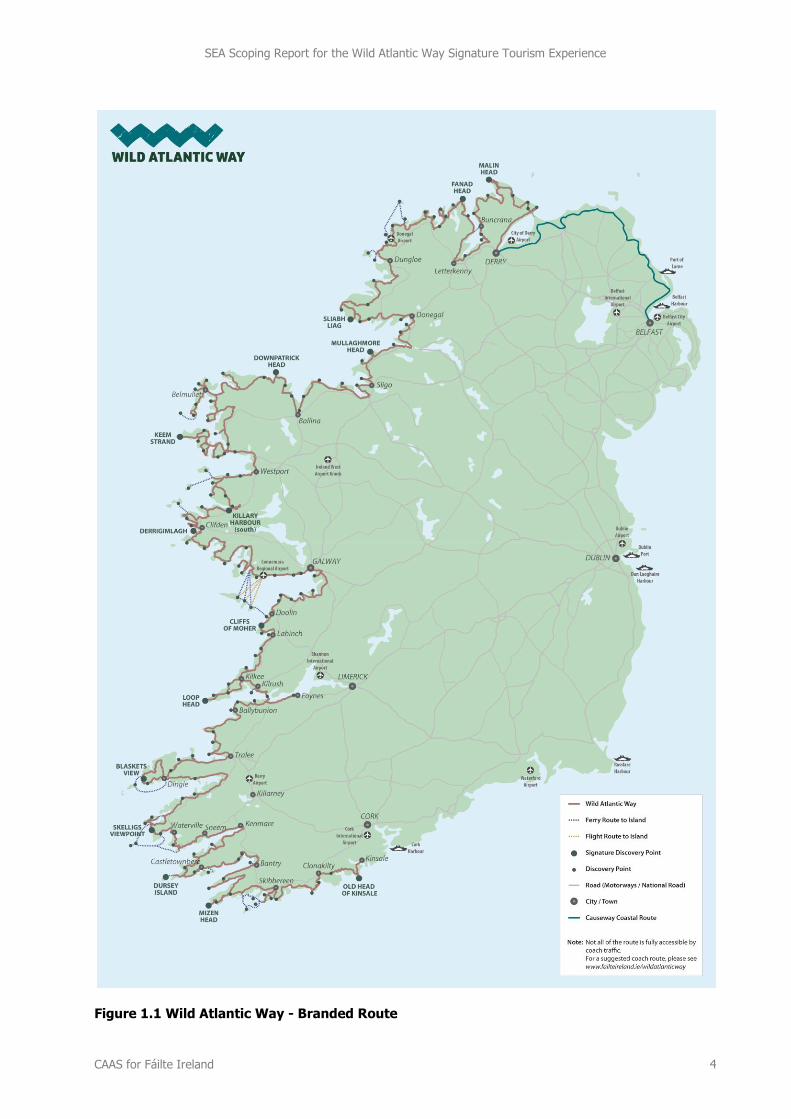
The Wild Atlantic Way (WAW) will be Ireland's first long-distance touring route, stretching approximately
2,500km along the Atlantic coast from Donegal to West Cork.
The WAW comprises coordinated re-branding and linking of a number of existing touring routes that will lead the visitor along Ireland’s Atlantic coast, and will allow travellers to see and be introduced to many
outstanding aspects of the Atlantic coastline.
1.2.1 Aims and Objectives
The WAW is one of Fáilte Ireland signature propositions to rejuvenate Irish tourism. The overall aim is to
create an overarching tourism brand for the west coast that will achieve greater visibility for the west coast of Ireland in overseas tourist markets. This overarching brand will consolidate a number of existing
touring routes and existing roads into a single long-distance touring route. Once fully-realised, the project
will:
create a single west coast of Ireland tourism brand and signature tourism experience that will
motivate visitors to travel to Ireland;
assist in increasing visitor numbers, dwell time, spend and satisfaction in destinations along and
close to the west coast of Ireland;
re-package the west of Ireland as a destination to overseas and domestic visitors;
highlight and promote existing visitor experiences that accord with the WAW proposition;
improve on-road interpretation, infrastructure and signage along and around the route;
direct visitors to less-visited areas; and
assist businesses, agencies, local groups and other stakeholders along the area to work together
under a single, unifying tourism proposition.
SEA Scoping Report for the Wild Atlantic Way Signature Tourism Experience
CAAS for Fáilte Ireland 4
Figure 1.1 Wild Atlantic Way - Branded Route
SEA Scoping Report for the Wild Atlantic Way Signature Tourism Experience
CAAS for Fáilte Ireland 5
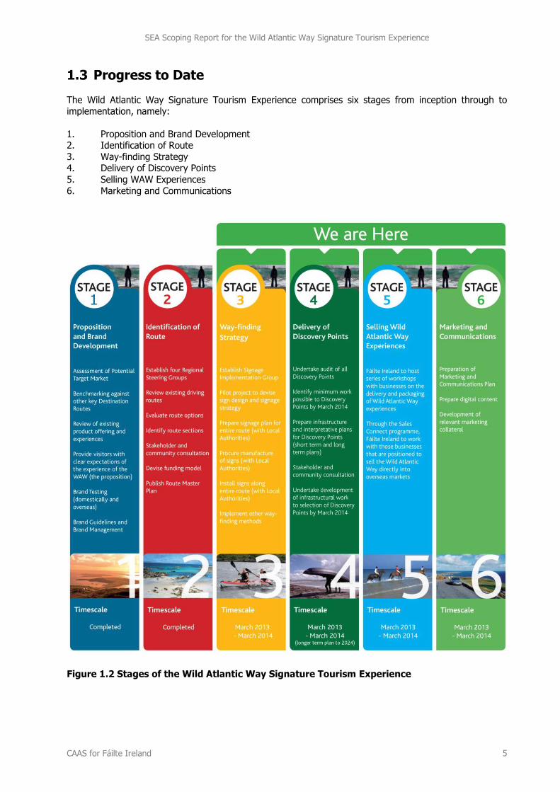
1.3 Progress to Date
The Wild Atlantic Way Signature Tourism Experience comprises six stages from inception through to implementation, namely:
1. Proposition and Brand Development 2. Identification of Route
3. Way-finding Strategy 4. Delivery of Discovery Points
5. Selling WAW Experiences
6. Marketing and Communications
Figure 1.2 Stages of the Wild Atlantic Way Signature Tourism Experience
SEA Scoping Report for the Wild Atlantic Way Signature Tourism Experience
CAAS for Fáilte Ireland 6
There are three overarching elements of the WAW Signature Tourism Experience, specifically:
A Branding Exercise [comprising Stages 1 – 3];
A Plan for Interpretation and Infrastructure – and associated implementation measures
[comprising Stage 4]; and
Selling WAW visitor experiences and marketing of the WAW [comprising Stages 5 and 6].
1.3.1 The Branding Exercise (Stages 1 to 3)
The Branding Exercise articulates the concept and identifies which existing roads and touring routes
should be jointly identified and branded as a tourism experience. Stage 1 articulated the overall proposition for the Wild Atlantic Way, undertook the market research and developed the brand identity.
The core brand proposition is ‘where the land meets the sea, shaped by the wild Atlantic’. Stage 2
identified the route for the WAW based upon the core brand proposition. Route identification criteria were devised which were applied in order to identify the route (Route Identification Report available to
view at www.failteireland.ie/wildatlanticway). Stage 3 involves the branding of the WAW through the provision of directional signage along the route.
The outcome of this exercise is the publication of mapping and an associated signage plan, as Fáilte
Ireland routinely does annually for all other destinations, attractions and activities (see
www.discoverireland.ie/places-to-go).
1.3.2 WAW Plan for Interpretation and Infrastructure - Design and Implementation (Stage 4)
Separately, the WAW Plan for Interpretation and Infrastructure - Design and Implementation (‘the WAW
Plan’) will identify and design locations and themes for the proposed new ‘Discovery Points’.
Discovery Points will be specific locations along the main existing route spine that provide new and
exceptional Wild Atlantic experiences. These ‘Discovery Points’ relate directly to the coast and possess an immediate thematic relevance to the overall brand and essence of the project. In the main, Discovery
Points are sites which will provide exceptional views and at which there is an opportunity to provide some interpretation for the visitor. Many of the proposed sites are well known as existing viewing points, and
some are already well developed, while others are lesser known but offer significant potential. In general, they are located in remote coastal areas outside of the main settlements. As such, they are intended to
entice visitors to enjoy managed experiences in more remote and peripheral areas of the coast, thus
potentially extending dwell times in a sustainable manner.
This Plan will form the basis for specific works and to liaise with Local Authorities on the implementation of these projects and proposals. The output of this Plan will be a series of projects – some of which will
require future development consent and some of which have the potential to give rise to environmental
effects. A first phase of works will involve maintenance and repair work to the ‘arrival points’ (car parks) of the ‘Discovery Points’, all of which are existing structures. This stage will not include any physical
extension of these car parks. Further works to the Discovery points may include the installation of interpretative panels, the provision of paths, viewing areas or additional car parking spaces, for example.
1.3.3 Sales and Marketing (Stages 5 and 6)
The sales element of the initiative involves liaising with tourism attractions and business providers along
the route, to help them to align their offering to the core proposition of the Wild Atlantic Way, to ensure that visitors have great Wild Atlantic Way experiences to choose from. Through a targeted sales
programme, Fáilte Ireland will work closely with those tourism businesses that are best positioned to sell
SEA Scoping Report for the Wild Atlantic Way Signature Tourism Experience
CAAS for Fáilte Ireland 7
their Wild Atlantic Way experiences into the four main overseas markets of Great Britain, France,
Germany and the USA.
The marketing element of the initiative involves the development of a marketing strategy for the Wild Atlantic Way. A full range of marketing collateral and digital content will also be developed for the
initiative which will be rolled out in time for the launch of the route in March 2014.
1.3.4 Current Status
The first two stages of the project are complete, and the next four stages are being undertaken as
parallel work streams.
The proposition and brand identity for the WAW have been developed and the first iteration1 of the route
of the WAW has been identified. The route and location of Discovery Points as identified are subject to change depending on the findings of the SEA and AA.
The next stages of the project have commenced and these involve:
Signing the route;
Delivering the 'Discovery Points' (to commence following the completion of the SEA & AA);
Selling great Wild Atlantic Way experiences; and
Marketing the Wild Atlantic Way.
It is expected that the project will be launched in March 2014.
1.3.5 Decision to Undertake SEA
Arising from Article 9 of the European Communities (Environmental Assessment of Certain Plans and Programmes) Regulations 2004, as amended, there is a requirement to carry out environmental
assessment of certain types of plans. This includes plans and programmes for the tourism sector which
are not directly connected with or necessary to the management of a European site but, either individually or in combination with other plans, are likely to have a significant effect on any such site.
It is noted that it is Stage 4 of the WAW that provides a decision-making framework for future works and
actions. This is the part of the initiative where the development of a decision-making process occurs. Fáilte Ireland have, as a competent authority, determined that the implementation of Stage 4 of the
WAW has the potential, if unmitigated, to result in environmental effects, including on European sites and
have, accordingly commenced the preparation of a Strategic Environmental Assessment
The preceding Branding Stages (Stages 1 to 3) do not provide such a framework and will not give rise to works or physical effects that could impact on the environment because these are existing, long
established touring routes and other roads with established patterns of use and renewal. Unlike Stage 4,
these stages will not give rise to the need for other permits, permissions or assessments and are therefore outside the scope of this assessment. Likewise, it has been determined that Stages 5 and 6 will
not give rise to works or physical effects that could impact on the environment.
Depending on the outcome of this SEA, changes may have to be made to the location of some of the Discovery Points, which may in turn affect the line of the route. If this is the case, the line of the route
will be altered accordingly.
1 Details of the branding/signage are expected to evolve in response to a number of factors including ex-ante assessment of environmental effects and ex-post monitoring of effects in practice.
SEA Scoping Report for the Wild Atlantic Way Signature Tourism Experience
CAAS for Fáilte Ireland 8
Section 2 The Assessment Process
2.1 Legislative Context for SEA
Strategic Environmental Assessment (SEA) is the formal, systematic evaluation of the likely significant environmental effects of implementing a plan or programme, or variation to a plan or programme, before
a decision is made to adopt it. The SEA Directive2 requires, inter alia, that SEA is undertaken for certain
plans and programmes which are prepared for a number of sectors, including tourism.
The SEA Directive was transposed into Irish Law through the European Communities (Environmental Assessment of Certain Plans and Programmes) Regulations 2004 (Statutory Instrument Number (SI No.
435 of 2004) and the Planning and Development (SEA) Regulations 2004 (SI No. 436 of 2004). Both sets
of Regulations became operational on 21 July 2004. SI No. 435 of 2004 relates to the tourism sector and was amended by the European Communities (Environmental Assessment of Certain Plans and
Programmes) (Amendment) Regulations 2011 (SI No. 200 of 2011).
2.2 Appropriate Assessment - A Parallel Assessment
Appropriate Assessment (AA) screening is currently being undertaken on the WAW. AA is an impact
assessment process concerning Natura 2000, or European, sites - these sites have been designated or proposed for designation by virtue of their ecological importance.
The Habitats Directive3 requires, inter alia, that plans and programmes undergo AA screening to establish
the likely or potential effects arising from implementation of the WAW. If the effects are deemed to be
significant, potentially significant or uncertain then the WAW must undergo Stage 2 AA.
The preparation of the WAW Plan, SEA and AA are taking place concurrently and the findings of the AA will inform both the SEA and the WAW Plan. The SEA will follow elements of Integrated Biodiversity
Assessment4.
Submissions/parts of submissions on AA made during the SEA Scoping process will be taken into account
while undertaking the AA as relevant.
2.3 Expected outcomes of the SEA (and AA)
Expected outcomes of the SEA (and AA) process will include:
The refinement (by possibly omission or adjustment) of the current list of Discovery Points by the
findings and mitigation measures arising from the SEA (and AA);
The guiding of the designs for works (if any) at Discovery Points by the findings and mitigation measures arising from the SEA (and AA);
The provision of criteria to be taken into account in the undertaking of any lower-tier AA for
individual Discovery Points; and
The setting up of a monitoring programme by Fáilte Ireland to provide new spatial data on visitor
numbers and environmental quality, as monitored by environmental authorities.
2 Directive 2001/42/EC on the Assessment of the Effects of Certain Plans and Programmes on the Environment 3 Directive 92/43/EEC on the conservation of natural habitats and of wild fauna and flora 4 As detailed in the EPA’s 2013 Integrated Biodiversity Impact Assessment - Streamlining AA, SEA and EIA Processes: Practitioner’s Manual.
SEA Scoping Report for the Wild Atlantic Way Signature Tourism Experience
CAAS for Fáilte Ireland 9
2.4 Consultation with environmental authorities
As part of the scoping process, environmental authorities5 were notified that a submission or observation in relation to the scope and level of detail of the information to be included in the environmental report
may be made to Fáilte Ireland. The following scoping questions for environmental authorities were
included in an earlier version of this report which accompanied the notice in order to facilitate submissions from the authorities.
1. Are there any additional best practice actions, to those detailed in this report, which should be
considered by the SEA?
2. Are there any additional scoping issues, to those detailed in this report, which should be
considered by the SEA?
3. Are there any additional potential interactions with plans or projects that could be relevant?
4. Are there any suggestions for relevant SEOs, indicators and targets that might be used for the
assessment?
5. Is new data for any of the environmental components expected to be published later in 2013 or in 2014? If so, when is it expected that this data will be published?
6. Is there information available on the zone of influence of designated ecological sites including Natura 2000 sites?
7. Have any Conservation Management Plans for SACs or SPAs along the WAW route been prepared
or is there any currently in preparation?
Submissions were made by the Environmental Protection Agency and the Department of Arts, Heritage
and the Gaeltacht which have resulted in various updates being made to the original version of this report, which was sent to the authorities with the SEA scoping notices. This final, revised report now sets
out the scope of the assessment to be undertaken.
2.5 What happens next?
Taking into account the content of this SEA Scoping Report and continuous scoping of the SEA, an SEA Environmental Report will be prepared and will accompany the draft WAW Plan for Interpretation and Infrastructure - Design and Implementation on public display.
5 The following authorities have been notified: Environmental Protection Agency, Department of Communications, Energy and Natural Resources, Department of Agriculture, Fisheries and Food, Department of the Environment, Community and Local Government and the Department of Arts, Heritage and the Gaeltacht.

SEA Scoping Report for the Wild Atlantic Way Signature Tourism Experience
CAAS for Fáilte Ireland 10
Section 3 Actions for SEA Best Practice
In order to contribute towards achieving SEA Best Practice for the SEA of the WAW, ‘SEA Strengths/Best Practice Examples’ and ‘Limits of SEA Effectiveness’ as identified in the Environmental Protection Agency’s Review of Effectiveness of SEA in Ireland 2012 - Key Findings and Recommendations Report (2012) were
examined.
The output of this examination is a list of actions for the WAW SEA as detailed on Table 3.1 below.
Progress on achieving the actions on this list will be updated throughout the SEA process and updated versions of the list will be included in both the SEA Environmental Report that is placed on display
alongside the Draft Plan and the SEA Statement which is produced at the end of the process.
SEA Stage No. Actions
Status/ Comments
1. Influence of SEA, Integration with Plan-Making
1a Ensure that the SEA process begins early in order to allow issues to be identified and appropriately addressed early in the preparation of the WAW Plan.
Achieved. Pre-scoping consultations with environmental authorities (EPA, NPWS) held.
1b Maximise buy-in to the SEA process from senior managers and decision-makers by communicating, at an early stage, the role and importance of SEA and integrating into the preparation of the WAW Plan and its adoption.
Achieved. Role and importance of SEA communicated to senior managers.
1c The SEA process should be highly integrated with both the preparation of the WAW Plan and the AA process.
Ongoing. Environmental considerations have been integrated into the preliminary consideration of WAW and will be continued throughout process.
2. Scoping
2a SEA scoping should focus sufficiently on the critical issues and key likely significant effects - guided by environmental authority consultation.
Ongoing. - This Report has been updated to take account of the submissions made by the
environmental authorities. - Pre-scoping consultations with environmental authorities (EPA, NPWS) have been held on both SEA and AA issues. - Key Scoping Issues are identified in Section 4 of this report.
2b Integrate available AA findings into SEA scoping process.
Ongoing - see Sections 2.2, 4.1 and 5.2. The SEA will follow elements of Integrated Biodiversity Assessment.
2c Make reference as appropriate to the potential for cumulative/ in combination effects (taking into account other relevant plans, programmes and
projects).
Ongoing - see Sections 4.5 and 4.7.
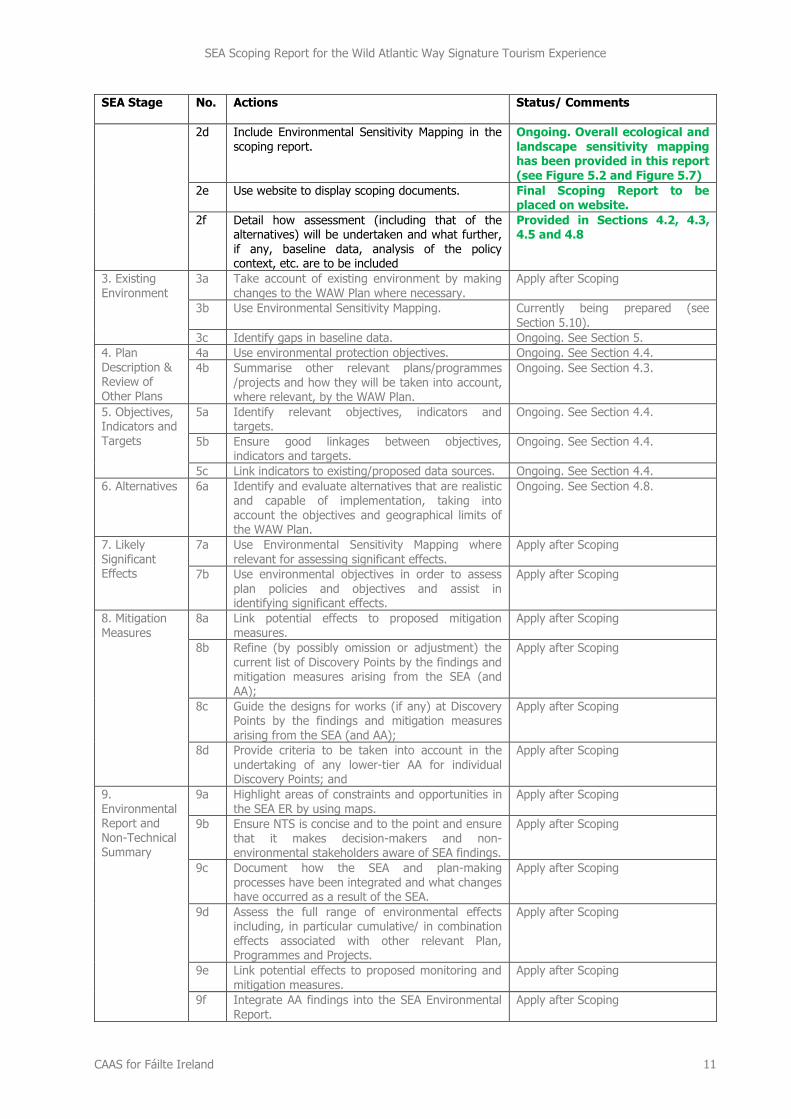
SEA Scoping Report for the Wild Atlantic Way Signature Tourism Experience
CAAS for Fáilte Ireland 11
SEA Stage No. Actions
Status/ Comments
2d Include Environmental Sensitivity Mapping in the scoping report.
Ongoing. Overall ecological and landscape sensitivity mapping has been provided in this report (see Figure 5.2 and Figure 5.7)
2e Use website to display scoping documents. Final Scoping Report to be placed on website.
2f Detail how assessment (including that of the alternatives) will be undertaken and what further, if any, baseline data, analysis of the policy context, etc. are to be included
Provided in Sections 4.2, 4.3, 4.5 and 4.8
3. Existing Environment
3a Take account of existing environment by making changes to the WAW Plan where necessary.
Apply after Scoping
3b Use Environmental Sensitivity Mapping. Currently being prepared (see
Section 5.10).
3c Identify gaps in baseline data. Ongoing. See Section 5.
4. Plan Description & Review of Other Plans
4a Use environmental protection objectives. Ongoing. See Section 4.4.
4b Summarise other relevant plans/programmes /projects and how they will be taken into account, where relevant, by the WAW Plan.
Ongoing. See Section 4.3.
5. Objectives, Indicators and Targets
5a Identify relevant objectives, indicators and targets.
Ongoing. See Section 4.4.
5b Ensure good linkages between objectives, indicators and targets.
Ongoing. See Section 4.4.
5c Link indicators to existing/proposed data sources. Ongoing. See Section 4.4. 6. Alternatives
6a Identify and evaluate alternatives that are realistic and capable of implementation, taking into account the objectives and geographical limits of the WAW Plan.
Ongoing. See Section 4.8.
7. Likely Significant Effects
7a Use Environmental Sensitivity Mapping where relevant for assessing significant effects.
Apply after Scoping
7b Use environmental objectives in order to assess plan policies and objectives and assist in identifying significant effects.
Apply after Scoping
8. Mitigation Measures
8a Link potential effects to proposed mitigation measures.
Apply after Scoping
8b Refine (by possibly omission or adjustment) the current list of Discovery Points by the findings and mitigation measures arising from the SEA (and AA);
Apply after Scoping
8c Guide the designs for works (if any) at Discovery Points by the findings and mitigation measures arising from the SEA (and AA);
Apply after Scoping
8d Provide criteria to be taken into account in the
undertaking of any lower-tier AA for individual Discovery Points; and
Apply after Scoping
9. Environmental Report and Non-Technical Summary
9a Highlight areas of constraints and opportunities in the SEA ER by using maps.
Apply after Scoping
9b Ensure NTS is concise and to the point and ensure that it makes decision-makers and non-environmental stakeholders aware of SEA findings.
Apply after Scoping
9c Document how the SEA and plan-making processes have been integrated and what changes have occurred as a result of the SEA.
Apply after Scoping
9d Assess the full range of environmental effects including, in particular cumulative/ in combination effects associated with other relevant Plan, Programmes and Projects.
Apply after Scoping
9e Link potential effects to proposed monitoring and
mitigation measures.
Apply after Scoping
9f Integrate AA findings into the SEA Environmental Report.
Apply after Scoping
SEA Scoping Report for the Wild Atlantic Way Signature Tourism Experience
CAAS for Fáilte Ireland 12
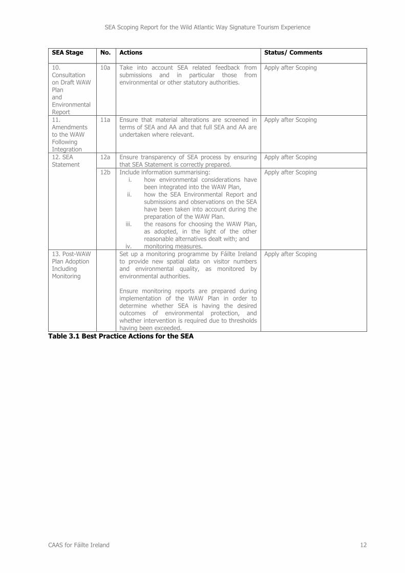
SEA Stage No. Actions
Status/ Comments
10. Consultation on Draft WAW Plan and Environmental Report
10a Take into account SEA related feedback from submissions and in particular those from environmental or other statutory authorities.
Apply after Scoping
11. Amendments to the WAW Following Integration
11a Ensure that material alterations are screened in terms of SEA and AA and that full SEA and AA are undertaken where relevant.
Apply after Scoping
12. SEA
Statement
12a Ensure transparency of SEA process by ensuring
that SEA Statement is correctly prepared.
Apply after Scoping
12b Include information summarising: i. how environmental considerations have
been integrated into the WAW Plan, ii. how the SEA Environmental Report and
submissions and observations on the SEA have been taken into account during the preparation of the WAW Plan.
iii. the reasons for choosing the WAW Plan, as adopted, in the light of the other reasonable alternatives dealt with; and
iv. monitoring measures.
Apply after Scoping
13. Post-WAW Plan Adoption Including
Monitoring
Set up a monitoring programme by Fáilte Ireland to provide new spatial data on visitor numbers and environmental quality, as monitored by
environmental authorities. Ensure monitoring reports are prepared during implementation of the WAW Plan in order to determine whether SEA is having the desired outcomes of environmental protection, and whether intervention is required due to thresholds having been exceeded.
Apply after Scoping
Table 3.1 Best Practice Actions for the SEA
SEA Scoping Report for the Wild Atlantic Way Signature Tourism Experience
CAAS for Fáilte Ireland 13
Section 4 Key Scoping Issues
4.1 Legislation and Guidelines
The SEA (and AA) will ensure compliance with the following legislation:
The SEA Directive and the Habitats and Birds Directives;
The European Communities (Environmental Assessment of Certain Plans and Programmes)
Regulations 2004 (Statutory Instrument Number (SI No. 435 of 2004);
The European Communities (Environmental Assessment of Certain Plans and Programmes)
(Amendment) Regulations 2011 (SI No. 200 of 2011);
The Planning and Development Acts 2000 to 2011; and
The European Communities (Birds and Natural Habitats) Regulations 2011.
In addition to complying with the legislation, the processes will be undertaken taking into account the
following guidance and associated documents:
Implementation of SEA Directive (2001/42/EC): Guidelines for Regional Authorities and Planning Authorities. Department of the Environment, Heritage and Local Government, 2004;
Appropriate Assessment of Plans and Projects in Ireland. Guidance for Planning Authorities.
Department of the Environment, Heritage and Local Government, 2009;
Assessment of plans and projects significantly affecting Natura 2000 sites: Methodological guidance on the provisions of Article 6(3) and (4) of the Habitats Directive 92/43/EEC, European
Commission Environment DG, 2000;
Managing Natura 2000 sites: The Provisions of Article 6 of the Habitats Directive 92/43/EEC: European Commission, 2000;
Guidance on Integrating Climate Change and Biodiversity into Strategic Environmental Assessment, European Commission, 2013;
Integrated Biodiversity Impact Assessment – Streamlining AA, SEA and EIA Processes: Practitioner’s Manual, Environment Protection Agency, 20137;
EPA GISEA Manual: Current Practice and Potential on the Application of Geographical Information Systems as a Support Tool in Strategic Environmental Assessment of Irish Land Use Plans, Environment Protection Agency, 20098;
Emerging Guidance on Alternatives, Environment Protection Agency, ongoing9; and
Relevant European Court of Justice judgements.
7 Prepared by CAAS GIS Specialist Ainhoa González & Containing CAAS SEA Case Studies 8 Prepared by CAAS GIS Specialist Ainhoa González & Containing CAAS SEA Case Studies 9 Currently being prepared by CAAS GIS Specialist Ainhoa González
SEA Scoping Report for the Wild Atlantic Way Signature Tourism Experience
CAAS for Fáilte Ireland 14
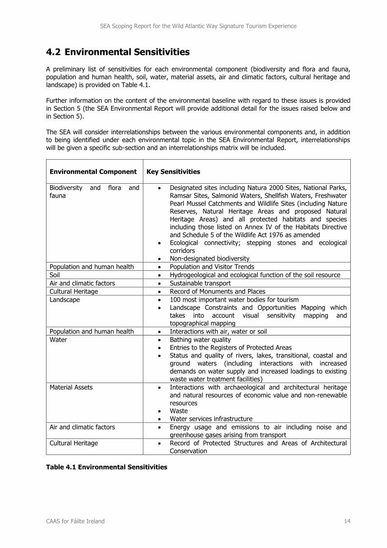
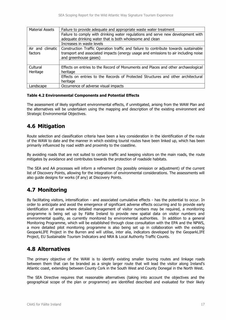
4.2 Environmental Sensitivities
A preliminary list of sensitivities for each environmental component (biodiversity and flora and fauna, population and human health, soil, water, material assets, air and climatic factors, cultural heritage and
landscape) is provided on Table 4.1.
Further information on the content of the environmental baseline with regard to these issues is provided
in Section 5 (the SEA Environmental Report will provide additional detail for the issues raised below and in Section 5).
The SEA will consider interrelationships between the various environmental components and, in addition to being identified under each environmental topic in the SEA Environmental Report, interrelationships
will be given a specific sub-section and an interrelationships matrix will be included.
Environmental Component
Key Sensitivities
Biodiversity and flora and
fauna
Designated sites including Natura 2000 Sites, National Parks,
Ramsar Sites, Salmonid Waters, Shellfish Waters, Freshwater
Pearl Mussel Catchments and Wildlife Sites (including Nature Reserves, Natural Heritage Areas and proposed Natural
Heritage Areas) and all protected habitats and species including those listed on Annex IV of the Habitats Directive
and Schedule 5 of the Wildlife Act 1976 as amended Ecological connectivity; stepping stones and ecological
corridors
Non-designated biodiversity
Population and human health Population and Visitor Trends
Soil Hydrogeological and ecological function of the soil resource
Air and climatic factors Sustainable transport
Cultural Heritage Record of Monuments and Places
Landscape 100 most important water bodies for tourism
Landscape Constraints and Opportunities Mapping which
takes into account visual sensitivity mapping and topographical mapping
Population and human health Interactions with air, water or soil
Water Bathing water quality
Entries to the Registers of Protected Areas
Status and quality of rivers, lakes, transitional, coastal and
ground waters (including interactions with increased
demands on water supply and increased loadings to existing waste water treatment facilities)
Material Assets Interactions with archaeological and architectural heritage
and natural resources of economic value and non-renewable
resources Waste
Water services infrastructure
Air and climatic factors Energy usage and emissions to air including noise and
greenhouse gases arising from transport
Cultural Heritage Record of Protected Structures and Areas of Architectural
Conservation
Table 4.1 Environmental Sensitivities
SEA Scoping Report for the Wild Atlantic Way Signature Tourism Experience
CAAS for Fáilte Ireland 15
4.3 Likely Interactions with Other Plans, Programmes and Projects
In considering the likely interactions with other Plans, Programmes and projects it is important to note that the WAW will be implemented within areas that have a wide range of existing plans and
programmes [relevant local, county, regional development plans] that are already subject to more specific higher and lower tier SEA that includes consideration of demographic and economic growth and
development [including transport, provision of water or waste services etc.]. Thus the higher level and
lower level potential effects have already been considered at different and more levels. Thus a series of more specific SEA already exist that assesses lower tier implementation of Community legislation on the
environment. Furthermore, project level planning permission involving, – where relevant, SEA and/or AA are specifically structured to implement Community legislation on environment – such as habitats and
water protection] – while higher level issues – such as waste management and water projection – are
assessed in relevant sectoral SEA [for Regional River Basin Management or Regional Waste Management – for example].
These are relevant considerations because Article 5 of the Directive (transposed through Article 12 of the
Regulations) specifically provides guidance about the stage at which to carry out SEA namely be having regard to ‘the extent to which certain matters are more appropriately assessed at different levels in that
process in order to avoid duplication of the assessment.’
The following is a preliminary list of other plans, programmes and projects that could potentially interact
with the WAW Plan. Further detail on these interactions will be provided in the SEA Environmental Report.
European SEA Directive;
Habitats Directive;
Birds Directive;
The EU climate and energy package;
Water Framework Directive;
Freshwater Fish Directive;
Shellfish Waters Directive;
Groundwater Directive;
Floods Directive;
Marine Strategy Framework Directive;
Drinking Water Directive;
Bathing Water Directive; and
EIA Directive.
National National Development Plan;
National Spatial Strategy;
National Climate Change Strategy;
National Renewable Energy Action Plan;
National Rural Development Programme;
Offshore Renewable Energy Development Plan;
Grid25 Implementation Programme;
Transport 21;
Our Sustainable Future – a Framework for Sustainable Development in Ireland;
Actions for Biodiversity 2011-2016 – Irelands National Biodiversity Plan; and
National Heritage Plan 2002.
Regional River Basin Management Plans;
Regional Planning Guidelines;
SEA Scoping Report for the Wild Atlantic Way Signature Tourism Experience
CAAS for Fáilte Ireland 16
Flood Risk Management Plans;
Regional Waste Management Plans;
Groundwater Protection Schemes; and
Water Services Strategic Plans.
Sub-Regional County and Town Development Plans;
Local Area Plans;
Economic development plans for rural and urban areas;
Shannon Estuary Strategic Implementation Framework Plan;
Biodiversity Action Plans;
Heritage Plans;
County Landscape Character Assessments;
County Renewable Energy Strategies;
Offshore and onshore energy generation projects;
Freshwater Pearl Mussel Sub-Basin Management Plans;
Shellfish Pollution Reduction Programmes; and
Existing and permitted infrastructure etc.
4.4 Strategic Environmental Objectives, Indicators and Targets
Strategic Environmental Objectives (SEOs), indicators and targets, which will focus on the Key Scoping Issues detailed on Table 4.1, will be used by the SEA in order to: describe the environmental baseline
contained in the SEA Environmental Report; evaluate WAW provisions; and inform the setting up of a
WAW monitoring programme (see also Section 4.7 below).
4.5 Potential Environmental Effects
Potential significant environmental effects, if unmitigated, and likely significant environmental effects, if
any, will be identified by the SEA and assessed. Such effects will include secondary, cumulative, synergistic, short, medium and long-term permanent and temporary, positive and negative effects.
Construction and operational impacts will be considered. Where appropriate, seasonality will be
considered in determining relevant effects. When assessing cumulative effects consideration will be given
to any outputs from national studies on cumulative effects in SEA.
Potentially significant environmental effects, if unmitigated, of implementing the WAW Plan, are expected to include those listed on Table 4.2 below.
Environmental Component
Potentially Significant Effect, if unmitigated, that are not already anticipated and assessed by the SEA/AA of existing interacting
programmes, plans and policies
Biodiversity and flora and fauna
Loss of biodiversity with regard to designated sites and species (including Natura 2000 Sites, Wildlife Sites and species listed on Schedule 5 of the Wildlife Act 1976
as amended)
Loss of biodiversity with regard to ecological connectivity
Loss of non-designated habitats
Disturbance to biodiversity and flora and fauna
Population and human health
Spatially concentrated deterioration in human health
Soil Adverse impacts on the hydrogeological and ecological function of the soil resource
Water Adverse impacts upon the status of water bodies (including interactions with increased demands on water supply and increased loadings to existing waste water
treatment facilities)
Adverse impacts upon bathing water quality
SEA Scoping Report for the Wild Atlantic Way Signature Tourism Experience
CAAS for Fáilte Ireland 17
Material Assets Failure to provide adequate and appropriate waste water treatment
Failure to comply with drinking water regulations and serve new development with
adequate drinking water that is both wholesome and clean
Increases in waste levels
Air and climatic
factors
Construction Traffic Operation traffic and failure to contribute towards sustainable
transport and associated impacts (energy usage and emissions to air including noise and greenhouse gases)
Cultural Heritage
Effects on entries to the Record of Monuments and Places and other archaeological heritage
Effects on entries to the Records of Protected Structures and other architectural
heritage
Landscape Occurrence of adverse visual impacts
Table 4.2 Environmental Components and Potential Effects
The assessment of likely significant environmental effects, if unmitigated, arising from the WAW Plan and the alternatives will be undertaken using the mapping and description of the existing environment and
Strategic Environmental Objectives.
4.6 Mitigation
Route selection and classification criteria have been a key consideration in the identification of the route
of the WAW to date and the manner in which existing tourist routes have been linked up, which has been
primarily influenced by road width and proximity to the coastline.
By avoiding roads that are not suited to certain traffic and keeping visitors on the main roads, the route mitigates by avoidance and contributes towards the protection of roadside habitats.
The SEA and AA processes will inform a refinement (by possibly omission or adjustment) of the current list of Discovery Points, allowing for the integration of environmental considerations. The assessments will
also guide designs for works (if any) at Discovery Points.
4.7 Monitoring
By facilitating visitors, intensification - and associated cumulative effects - has the potential to occur. In
order to anticipate and avoid the emergence of significant adverse effects occurring and to provide early identification of areas where detailed management of visitor numbers may be required, a monitoring
programme is being set up by Fáilte Ireland to provide new spatial data on visitor numbers and environmental quality, as currently monitored by environmental authorities. In addition to a general
Monitoring Programme, which will be established through close consultation with the EPA and the NPWS,
a more detailed pilot monitoring programme is also being set up in collaboration with the existing GeoparkLIFE Project in the Burren and will utilise, inter alia, indicators developed by the GeoparkLIFE
Project, EU Sustainable Tourism Indicators and NRA & Local Authority Traffic Counts.
4.8 Alternatives
The primary objective of the WAW is to identify existing smaller touring routes and linkage roads
between them that can be branded as a single larger route that will lead the visitor along Ireland’s Atlantic coast, extending between County Cork in the South West and County Donegal in the North West.
The SEA Directive requires that reasonable alternatives (taking into account the objectives and the geographical scope of the plan or programme) are identified described and evaluated for their likely
SEA Scoping Report for the Wild Atlantic Way Signature Tourism Experience
CAAS for Fáilte Ireland 18
significant effects on the environment. These alternative scenarios should be realistic and capable of
implementation.
Alternatives for the WAW are therefore limited by its primary objective which includes use of existing touring routes and proximity the coastline as a key criterion (the primary objective seeks to identify the
existing routes that lead the visitor along the coast). It does not provide for the construction of new
routes closer to the coastline (the primary objective only seeks to identify existing routes). It is noted, however, that the WAW route identification takes into account other criteria including an anticipation of
the capacity of the road and road safety having regard to the potential for such roads to absorb existing or likely future traffic without the need for upgrades or works likely to give rise to environmental effects.
Alternatives will therefore centre on the selection of Discovery Points and will be supplemented by a
consideration of alternatives for the WAW as follows:
A WAW route which takes into account both the capacity of the roads and road safety;
A WAW route which takes into account the capacity of the roads but not road safety;
A WAW route which takes into account road safety but not the capacity of the roads; and
A WAW route which does not take into account the capacity of the roads or road safety.
The assessment of likely significant environmental effects, if unmitigated, arising from the alternatives will be undertaken using the mapping and description of the existing environment and Strategic
Environmental Objectives.
SEA Scoping Report for the Wild Atlantic Way Signature Tourism Experience
CAAS for Fáilte Ireland 19
Section 5 Preliminary Identification of Environmental Baseline Content10
5.1 Introduction
This section provides a preliminary identification of the content of the environmental baseline that will be
used by the SEA. The environmental baseline, including descriptions and mapping will be updated
throughout the SEA process.
5.2 Biodiversity and Flora and Fauna
The SEA will consider available information on designated ecological sites and protected species,
ecological connectivity and non-designated habitats. Ecological designations include:
Special Areas of Conservation11 (SACs) and Special Protection Areas12 (SPAs);
UNESCO World Heritage and UNESCO Biosphere sites;
Areas Special Scientific Interest13;
Ramsar Sites14;
Salmonid Waters;
Shellfish Waters;
Freshwater Pearl Mussel catchments;
Flora Protection Order sites; and
Wildlife Sites (including Natural Heritage Areas15 and Nature Reserves).
The SEA will make use of available data sources including those from the National Parks and Wildlife
Service, the EPA’s Framework National Ecological Network for Ireland and CORINE land cover mapping.
The SEA will be informed by the findings of the AA and will follow elements of Integrated Biodiversity
Assessment with reference made to the EPA’s 2013 Integrated Biodiversity Impact Assessment - Streamlining AA, SEA and EIA Processes: Practitioner’s Manual. Route selection and classification criteria have been a key consideration in the development of the WAW
to date which has been primarily influenced by road width and proximity to the coastline. By avoiding
roads that are not suited to certain traffic and keeping visitors on the main roads, the route mitigates by avoidance and contributes towards the protection of roadside habitats.
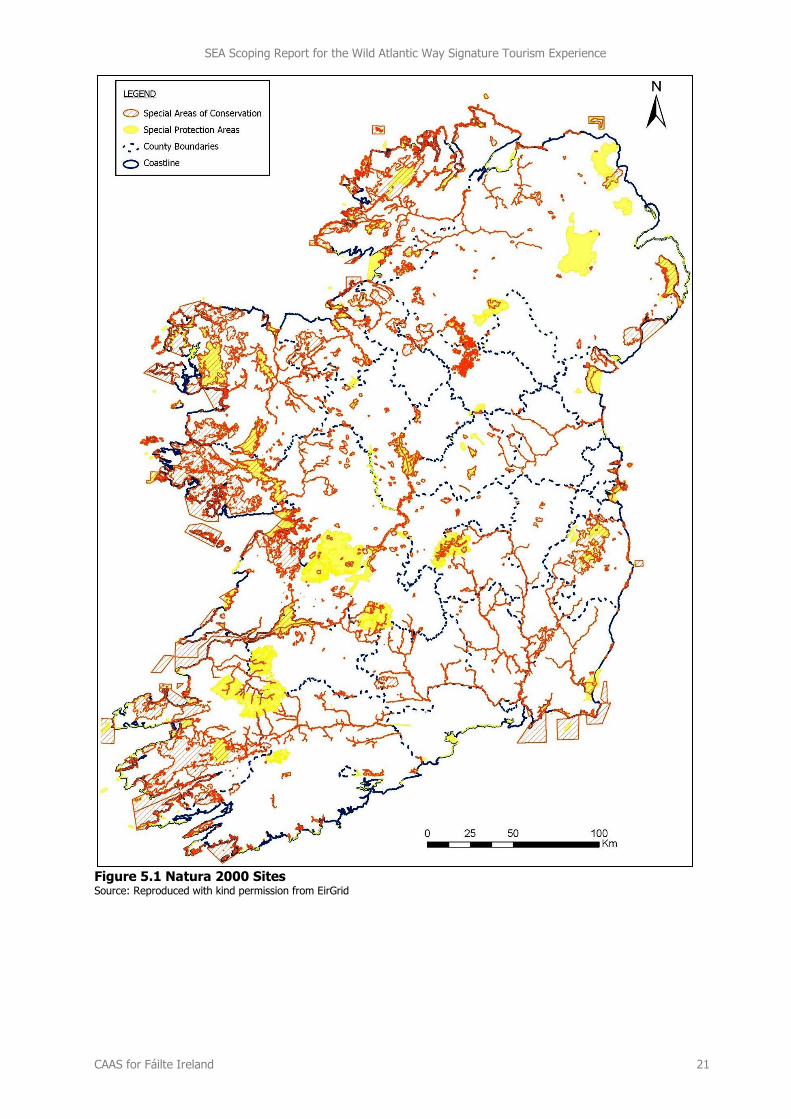
As indicated by Figure 5.1, much of the Atlantic coastal area along which the WAW route traverses is
located within or close to Natura 2000 sites.
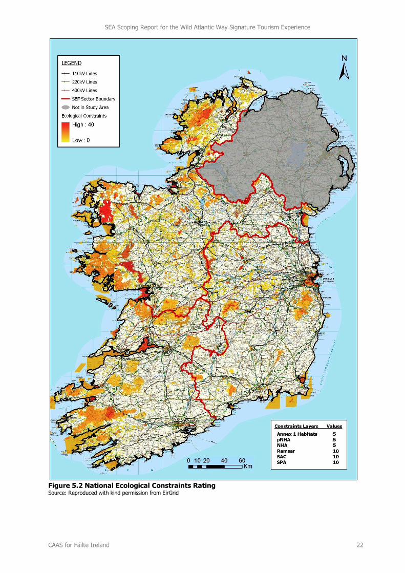
Figure 5.2 maps a National Ecological Constraints Rating16 which provides an indication of the areas that
are most ecologically sensitive development and is based on biodiversity designations, with the greatest weighting allocated to designations of European and international importance. Ecological constraints are
indicated by colours which range from most likely sensitivity (red) to likely sensitivity (yellow). In general, and on a national level, ecological constraints occur in greatest concentrations in the western half of the
10 Mapping in this section will be updated and added to in advance of the finalisation of the Scoping Report. 11 designated under the Habitats Directive (Directive 92/43/EEC on the conservation of natural habitats and of wild fauna and flora). 12 designated under the Birds Directive (EC Directive 79/409/EEC on the conservation of wild birds) 13 designated under the Environment (Northern Ireland) Order 2002 14 designated under the Convention on Wetlands of International Importance 15 designated under the Wildlife Act; 16 A weighting system applied through Geographical Information System (GIS) software was used in order to calculate the sensitivities of each area. A higher score for the European and international designations (SAC, SPA and Ramsar) reflects the greater significance of these designations when considering infrastructure development. Three factors were attributed a rating of 10 points: Ramsar Sites; SACs; and SPAs. Three factors were attributed a weighting of 5 points: NHAs; Proposed NHAs; and areas likely to contain a habitat listed in annex 1 of the Habitats Directive that have been deduced from the CORINE land cover dataset.
SEA Scoping Report for the Wild Atlantic Way Signature Tourism Experience
CAAS for Fáilte Ireland 20
country and in particular along the western seaboard (including north-western and south-western
coasts).
The following datasets will be considered while compiling data on the baseline environment:
Nature conservation designations;
Available information on habitats, rare and protected species and their habitats;
Watercourses and associated wetlands; and
Other sites of high biodiversity value or ecological importance, e.g. BirdWatch Ireland’s
‘Important Bird Areas’ (Crowe et al., 2009) and sites identified as a result of local authority
Heritage Plans or Biodiversity Plans.
SEA Scoping Report for the Wild Atlantic Way Signature Tourism Experience
CAAS for Fáilte Ireland 21
Figure 5.1 Natura 2000 Sites Source: Reproduced with kind permission from EirGrid
SEA Scoping Report for the Wild Atlantic Way Signature Tourism Experience
CAAS for Fáilte Ireland 22
Figure 5.2 National Ecological Constraints Rating Source: Reproduced with kind permission from EirGrid
SEA Scoping Report for the Wild Atlantic Way Signature Tourism Experience
CAAS for Fáilte Ireland 23
5.3 Population and Human Health
Available information on visitor numbers to the West (which incorporates the Fáilte Ireland tourism
regions of North West, West, Shannon and South West) between 1999 and 2011 show that the average number of visitors amounted to 3,066,000, with visitor numbers peaking in 2007 (3,638,000).
Visitor numbers have generally declined since 2007. In 2011, the most recent year for which data is available, there were 2,841,000 visitors.
With regard to human health, impacts relevant to the SEA are those which arise as a result of
interactions with environmental vectors (i.e. environmental components such as air, water or soil through
which contaminants or pollutants, which have the potential to cause harm, can be transported so that they come into contact with human beings). Hazards or nuisances to human health can arise as a result
of exposure to these vectors arising from incompatible adjacent landuses, for example.
5.4 Soil
To date, there is no legislation which is specific to the protection of soil resources. However, there is
currently an EU Thematic Strategy on the protection of soil which includes a proposal for a Soil Framework Directive, including the proposal of common principles for protecting soils across the EU.
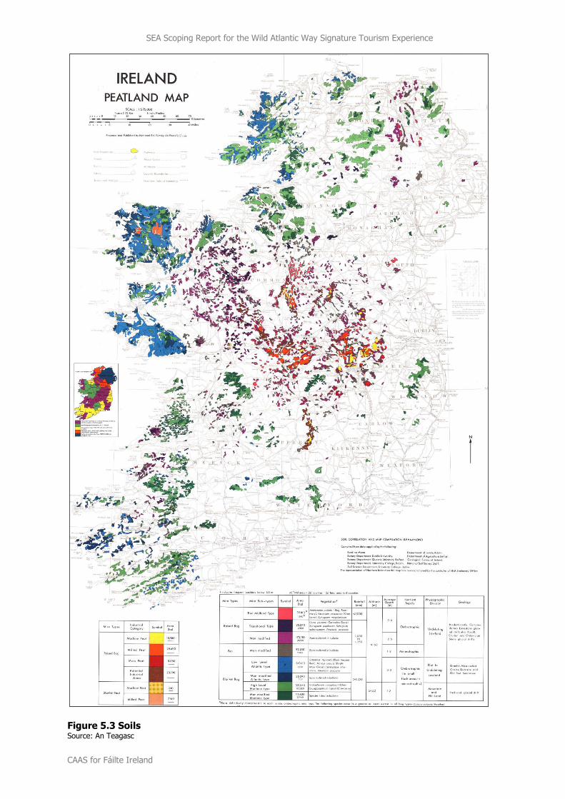
Peat soils generally provide the least amount of physical support for built development and are found in various areas along the Atlantic coastline. The spatial spread of various types of peat soils is mapped on
Figure 5.3.
In addition to soils, the SEA will consider published national data on important geological features. The GSI and the DAHG are currently identifying sites of geological interest across the Country that will be
proposed as Natural Heritage Areas.
SEA Scoping Report for the Wild Atlantic Way Signature Tourism Experience
CAAS for Fáilte Ireland 24
Figure 5.3 Soils Source: An Teagasc
SEA Scoping Report for the Wild Atlantic Way Signature Tourism Experience
CAAS for Fáilte Ireland 25
5.5 Water
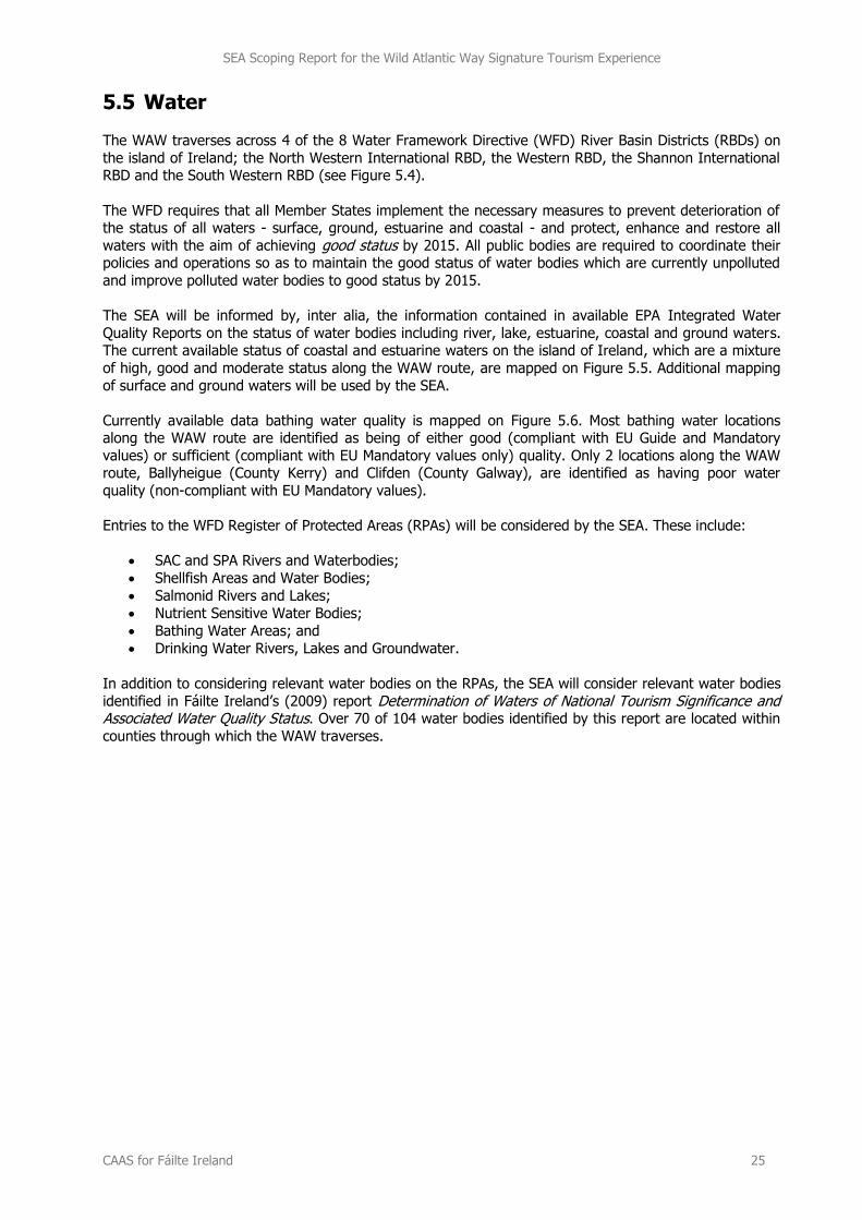
The WAW traverses across 4 of the 8 Water Framework Directive (WFD) River Basin Districts (RBDs) on
the island of Ireland; the North Western International RBD, the Western RBD, the Shannon International RBD and the South Western RBD (see Figure 5.4).
The WFD requires that all Member States implement the necessary measures to prevent deterioration of the status of all waters - surface, ground, estuarine and coastal - and protect, enhance and restore all
waters with the aim of achieving good status by 2015. All public bodies are required to coordinate their policies and operations so as to maintain the good status of water bodies which are currently unpolluted
and improve polluted water bodies to good status by 2015.
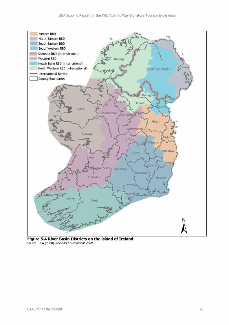
The SEA will be informed by, inter alia, the information contained in available EPA Integrated Water
Quality Reports on the status of water bodies including river, lake, estuarine, coastal and ground waters. The current available status of coastal and estuarine waters on the island of Ireland, which are a mixture
of high, good and moderate status along the WAW route, are mapped on Figure 5.5. Additional mapping
of surface and ground waters will be used by the SEA.
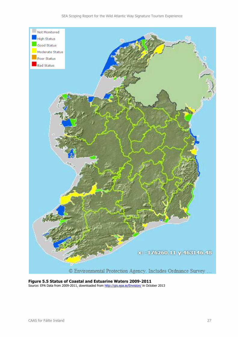
Currently available data bathing water quality is mapped on Figure 5.6. Most bathing water locations along the WAW route are identified as being of either good (compliant with EU Guide and Mandatory
values) or sufficient (compliant with EU Mandatory values only) quality. Only 2 locations along the WAW route, Ballyheigue (County Kerry) and Clifden (County Galway), are identified as having poor water
quality (non-compliant with EU Mandatory values).
Entries to the WFD Register of Protected Areas (RPAs) will be considered by the SEA. These include:
SAC and SPA Rivers and Waterbodies;
Shellfish Areas and Water Bodies;
Salmonid Rivers and Lakes;
Nutrient Sensitive Water Bodies;
Bathing Water Areas; and
Drinking Water Rivers, Lakes and Groundwater.
In addition to considering relevant water bodies on the RPAs, the SEA will consider relevant water bodies
identified in Fáilte Ireland’s (2009) report Determination of Waters of National Tourism Significance and Associated Water Quality Status. Over 70 of 104 water bodies identified by this report are located within
counties through which the WAW traverses.
SEA Scoping Report for the Wild Atlantic Way Signature Tourism Experience
CAAS for Fáilte Ireland 26
Figure 5.4 River Basin Districts on the island of Ireland Source: EPA (2008) Ireland’s Environment 2008
SEA Scoping Report for the Wild Atlantic Way Signature Tourism Experience
CAAS for Fáilte Ireland 27
Figure 5.5 Status of Coastal and Estuarine Waters 2009-2011 Source: EPA Data from 2009-2011, downloaded from http://gis.epa.ie/Envision/ in October 2013
SEA Scoping Report for the Wild Atlantic Way Signature Tourism Experience
CAAS for Fáilte Ireland 28
Figure 5.6 Bathing Water Quality 2012 Source: EPA (2013) The Quality of Bathing Water in Ireland - An Overview for the Year 2012
SEA Scoping Report for the Wild Atlantic Way Signature Tourism Experience
CAAS for Fáilte Ireland 29
5.6 Air and Climatic Factors
5.6.1 Air
Air Quality
In order to comply with European Directives relating to air quality, the EPA measures the levels of a number of atmospheric pollutants. For the purposes of monitoring in Ireland, four zones are defined in
the Air Quality Standards Regulations 2002 (SI No. 271 of 2002). The main areas defined in each zone are:
Zone A: Dublin Conurbation.
Zone B: Cork Conurbation.
Zone C: Other cities and large towns comprising Galway, Limerick, Waterford, Clonmel, Kilkenny,
Sligo, Drogheda, Wexford, Athlone, Ennis, Bray, Naas, Carlow, Tralee, Dundalk, Navan, Letterkenny, Celbridge, Newbridge, Mullingar, Balbriggan, Greystones, Leixlip and Portlaoise.
Zone D: Rural Ireland, i.e. the remainder of the State - small towns and rural areas of the
country - excluding Zones A, B and C.
Air quality in all of these zones is currently “good”. The EPA’s (EPA, 2013) Air Quality in Ireland 2012 identifies that air quality in Ireland continues to be good and is among the best in Europe.
Noise Noise is unwanted sound. The Environmental Noise Regulations (SI No. 140 of 2006) transpose into Irish
law the EU Directive 2002/49/EC relating to the assessment and management of environmental noise, which is commonly referred to as the Environmental Noise Directive or END. The END defines a common
approach intended to avoid, prevent or reduce on a prioritised basis the harmful effects, including
annoyance, due to exposure to environmental noise. The END does not set any limit value, nor does it prescribe the measures to be used in the action plans, which remain at the discretion of the competent
authorities. Limit values are left to each member state. At this point in time, Ireland does not have any statutory noise limit values.
5.6.2 Climatic Factors
The key issue involving the assessment of the effects of implementing the WAW Plan on climatic factors relates to greenhouse gas emissions arising from transport.
The EPA 2013 publication Ireland’s Greenhouse Gas Emission Projections 2012-2030, identifies that
Ireland is on track to meet its commitment under the Kyoto Protocol, primarily, a direct result of the
current economic recession and economic outlook for the future. However, the report also identifies that there continues to be a significant risk that Ireland will not meet its target for 2020 under the EU Effort
Sharing Decision, with strong projected growth in emissions from transport and agriculture.
Transport is a source of:
1. Noise;
2. Air emissions; and 3. Energy use (39.9% of Total Final Consumption of Energy in Ireland in 2011 was taken up by
transport, the largest take up of any sector17).
By providing more sustainable modes and levels of mobility, noise and other emissions to air and energy
use can be minimised. Maximising sustainable mobility will also help Ireland meet its greenhouse gas emission target for 2020 under the EU Effort Sharing Decision which commits Ireland to reducing
emissions from those sectors that are not covered by the Emissions Trading Scheme (e.g. transport, agriculture, residential) to 20% below 2005 levels.
17 Sustainable Energy Ireland (2012) Energy in Ireland 1990-2011
SEA Scoping Report for the Wild Atlantic Way Signature Tourism Experience
CAAS for Fáilte Ireland 30
5.7 Material Assets
Resources that are valued and that are intrinsic to specific places are called ‘material assets’. Material
Assets that will be considered by the SEA include:
Settlements
Water services infrastructure
Waste
Archaeological and architectural heritage (see Section 5.8)
Natural resources of economic value, such as air and water18 (see Sections 5.6 and 5.5) and non-
renewable resources.
With regard to water services infrastructure and services, it is noted that these are planned and
permitted through specific processes which are informed by, inter alia, the needs of land use plans including County Development Plans and Local Area Plans which are required to take into account
fluctuating needs, such as those that may arise as a result of existing and future numbers of residents
and tourists.
5.8 Cultural Heritage
With regard to cultural heritage, the SEA will consider archaeological and architectural heritage.
5.8.1 Archaeological Heritage
Archaeological sites and monuments vary greatly in form and date; examples include earthworks of
different types and periods, (e.g. early historic ringforts and prehistoric burial mounds), megalithic tombs from the Prehistoric period, medieval buildings, urban archaeological deposits, and underwater features.
Archaeological sites may have no visible surface features; the surface features of an archaeological site
may have decayed completely or been deliberately removed but archaeological deposits and features may survive beneath the surface. Archaeological heritage is protected under the National Monuments
Acts (1930-2004), Natural Cultural Institutions Act 1997, and the Planning and Development Acts 2000-2010.
A primary source of information for known archaeological features is the Record of Monuments and Places (RMP) which was established under the National Monuments Acts 1930 to 2004. The RMP is an
inventory, put on a statutory basis by amendment to the National Monuments Act 1994, of sites and areas of archaeological significance. It records known upstanding archaeological monuments, the original
location of destroyed monuments, and the location of possible sites identified through documentary, cartographic and photographic research.
The term ‘monument’ includes all man-made structures of whatever form or date except buildings habitually used for ecclesiastical purposes. All monuments in existence before 1700 A.D. are
automatically considered to be historic monuments within the meaning of the National Monuments Acts.
The likely significant effects of implementing the WAW Plan on environmental components including
archaeology will be identified and evaluated in compliance with the Strategic Environmental Assessment Directive. The guidance provided on Archaeological Impact Assessment will be taken into account during
the undertaking of the SEA, especially with regard to the setting of requirements for lower tier projects.
Consideration will be given to underwater archaeology including shipwrecks and the National Monuments Acts during the SEA process as appropriate. It is not expected at this stage that actual conflicts will arise
between underwater archaeology such as shipwrecks and the WAW Plan.
18 Including water bodies identified in Fáilte Ireland’s (2009) report Determination of Waters of National Tourism Significance and Associated Water Quality Status.
SEA Scoping Report for the Wild Atlantic Way Signature Tourism Experience
CAAS for Fáilte Ireland 31
5.8.2 Architectural Heritage
The term architectural heritage is defined in the Architectural Heritage (National Inventory) and Historic
Monuments (Miscellaneous Provisions) Act 1999 as meaning all structures and buildings together with their settings and attendant grounds, fixtures and fittings; groups of structures and buildings; and sites
which are of technical, historical, archaeological, artistic, cultural, scientific, social, or technical interest.
A primary source of information for known architectural heritage is the Record of Protected Structures
(RPS) of every local authority which is legislated for under Section 51 of the Planning and Development Acts 2000-2010. Inclusion of structures or parts of structures which form part of the architectural
heritage and which are of special architectural, historical, archaeological, artistic, cultural, scientific, social or technical interest, on these records contributes towards the protection of architectural heritage.
Protected structures are defined by Section 2 of the Planning and Development Acts to mean “(a) a structure, or (b) a specified part of a structure, which is included in a record of protected structures, and,
where that record so indicates, includes any specified feature which is within the attendant grounds of the structure…”
In addition to Protected Structures, the Planning and Development Acts 2000-2010 provide the legislative basis for the protection of areas known as Architectural Conservation Areas (ACAs). An ACA is a place,
area or group of structures or townscape which is of special architectural, historical, archaeological, artistic, cultural, scientific, social or technical interest or value, or contributes to the appreciation of
protected structures, whose character it is an objective to preserve in a Development Plan.
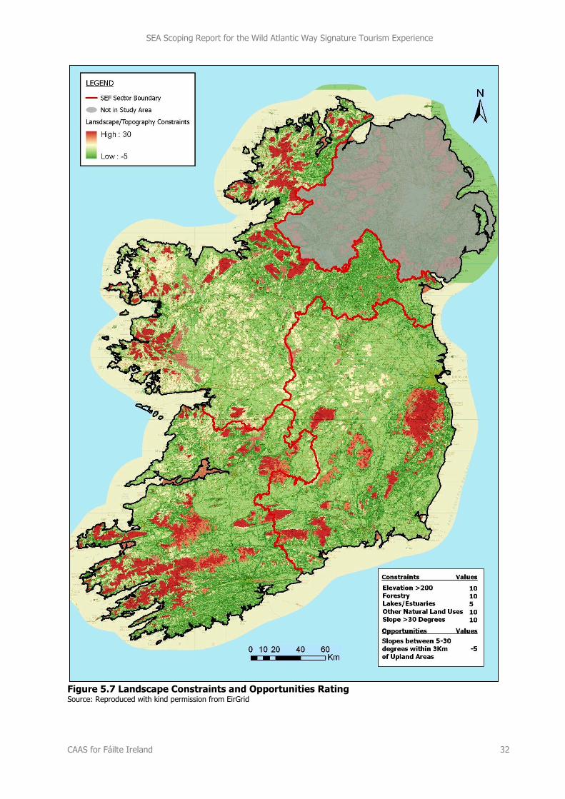
5.9 Landscape
The SEA will consider relevant water bodies identified in Fáilte Ireland’s (2009) report Determination of Waters of National Tourism Significance and Associated Water Quality Status. Over 70 of 104 water bodies identified by this report are located within counties through which the WAW traverses.
Landscape designations, which can be inconsistent at county borders, including landscape sensitivity classifications and protected views and prospects will also be considered by the SEA.
Figure 5.7 maps a Landscape Constraints and Opportunities Rating which provides an indication of the
areas that are most sensitive from a landscape perspective. In order to create this rating, various
landscape factors were given a value and overlaid upon each other19. The mapping combines Visual Sensitivity Mapping (as identified from the natural land cover types in the CORINE land cover dataset)
and Topographical Mapping (developed from a 50m digital terrain model and catchment watersheds).
Landscape Constraints are indicated by colours which range from most likely sensitivity (red) to likely
sensitivity (lighter red) while Landscape Opportunities are shown in green. Landscape constraints occur at a number of locations along the WAW route and these will be taken into account by the SEA.
19 A weighting system applied through Geographical Information System (GIS) software was used in order to calculate the sensitivities of each area. Three factors were attributed a rating of 10 points:
Elevation >200m; Forestry Landcover Areas; and, Slope >30 Degrees).
Two factors were attributed a weighting of 5 points:
Lakes and Estuaries; and, Other Natural Landcover Types.
One factor was attributed a weighting of minus 5 points:
Areas of land within 3km of the 200km contour and under 200 metres and with a slope between 5 degrees and 30 degrees.
SEA Scoping Report for the Wild Atlantic Way Signature Tourism Experience
CAAS for Fáilte Ireland 32
Figure 5.7 Landscape Constraints and Opportunities Rating Source: Reproduced with kind permission from EirGrid
SEA Scoping Report for the Wild Atlantic Way Signature Tourism Experience
CAAS for Fáilte Ireland 33
5.10 Overlay Mapping of Environmental Sensitivities
Overlay mapping of environmental sensitivities will be prepared and used in subsequent SEA stages.