Embed Size (px)
Citation preview

Stratigraphic Correlations Between the Eagle Valley Evaporite and Minturn Formation, Eagle Basin, Northwest Colorado
U.S. GEOLOGICAL SURVEY BULLETIN 1787-GG

AVAILABILITY OF BOOKS AND MAPS OF THE U.S. GEOLOGICAL SURVEY
Instructions on ordering publications of the U.S. Geological Survey, along with the last offerings, are given in the current-year issues of the monthly catalog "New Publications of the U.S. Geological Survey." Prices of available U.S. Geological Survey publications released prior to the current year are listed in the most recent annual "Price and Availability List." Publications that are listed in various U.S. Geological Survey catalogs (see back inside cover) but not listed in the most recent annual "Price and Availability List" are no longer available.
Prices of reports released to the open files are given in the listing "U.S. Geological Survey Open-File Reports," updated monthly, which is for sale in microfiche from the U.S. Geological Survey Books and Open-File Reports Sales, Box 25286, Denver, CO 80225.
Order U.S. Geological Survey publications by mail or over the counter from the offices given below.
BY MAIL
Books
Professional Papers, Bulletins, Water-Supply Papers, Tech niques of Water-Resources Investigations, Circulars, publications of general interest (such as leaflets, pamphlets, booklets), single copies of periodicals (Earthquakes & Volcanoes, Preliminary De termination of Epicenters), and some miscellaneous reports, includ ing some of the foregoing series that have gone out of print at the Superintendent of Documents, are obtainable by mail from
U.S. Geological Survey, Books and Open-File Report SalesBox 25286
Denver, CO 80225
Subscriptions to periodicals (Earthquakes & Volcanoes and Preliminary Determination of Epicenters) can be obtained ONLY from
Superintendent of DocumentsU.S. Government Printing Office
Washington, DC 20402
(Check or money order must be payable to Superintendent of Documents.)
Maps
For maps, address mail order to
U.S. Geological Survey, Map SalesBox 25286
Denver, CO 80225
Residents of Alaska may order maps from
U.S. Geological Survey, Map Sales101 Twelfth Ave., Box 12
Fairbanks, AK 99701
OVER THE COUNTER
Books
Books of the U.S. Geological Survey are available over the counter at the following U.S. Geological Survey offices, all of which are authorized agents of the Superintendent of Documents.
ANCHORAGE, Alaska-4230 University Dr., Rm. 101
ANCHORAGE, Alaska-605 West 4th Ave., Rm G-84
DENVER, Colorado-Federal Bldg., Rm. 169,1961 Stout St.
LAKEWOOD, Colorado-Federal Center, Bldg. 810
MENLO PARK, California-Bldg. 3, Rm. 3128, 345Middlefield Rd.
RESTON, Virginia-National Center, Rm. 1C402, 12201 Sunrise Valley Dr.
SALT LAKE CITY, Utah-Federal Bldg., Rm. 8105, 125 South State St.
SPOKANE, Washington-U.S. Courthouse, Rm. 678, West 920 Riverside Ave.
WASHINGTON, D.C.-U.S. Department of the Interior Bldg., Rm.2650,1849CSt.,NW.
Maps
Maps may be purchased over the counter at the U.S. Geolog ical Survey offices where books are sold (all addresses in above list) and at the following Geological Survey offices:
ROLLA, Missouri-1400 Independence Rd.
FAIRBANKS, Alaska-New Federal Building, 101 Twelfth Ave.

Chapter GG
Stratigraphic Correlations Between the Eagle Valley Evaporite and Minturn Formation, Eagle Basin, Northwest Colorado
By CHRISTOPHER J. SCHENK
A multidisciplinary approach to research studies of sedimentary rocks and their constituents and the evolution of sedimentary basins, both ancient and modern
U.S. GEOLOGICAL SURVEY BULLETIN 1787
EVOLUTION OF SEDIMENTARY BASINS UINTA AND PICEANCE BASINS

U.S. DEPARTMENT OF THE INTERIOR
MANUEL LUJAN, JR., Secretary
U.S. GEOLOGICAL SURVEY
Dallas L. Peck, Director
Any use of trade, product, or firm names in this publication is for descriptive purposes only and does not imply endorsement by the U.S. Government
UNITED STATES GOVERNMENT PRINTING OFFICE: 1992
For sale byBook and Open-File Report Sales U.S. Geological Survey Federal Center, Box 25286 Denver, CO 80225
Library of Congress Cataloging-in-Publication Data
Schenk, Christopher J.Stratigraphic correlations between the Eagle Valley Evaporite and Minturn
Formation, Eagle Basin, northwest Colorado / by Christopher J. Schenk.p. cm. (U.S. Geological Survey bulletin ; 1787)
(Evolution of sedimentary basins Uinta and Piceance basins; ch. GG)Includes bibliographical references.Supt. of Docs. no. 119.3: 1787GG1. Stratigraphic correlation Colorado. 2. Evaporites Colorado.
3. Geology, Stratigraphic Pennsylvanian. 4. Eagle Valley Formation (Colo.) 5. Minturn Formation (Colo.) I. Title. II. Series III. Series: Evolution of sedimentary basins Uinta and Piceance basins; ch. GG. QE75.B9 no. 1787-GG QE652.55 l.U]557.3 s dc20[551.7'52'09788] 2-15518
CIP

CONTENTS
Abstract GG1 Introduction GG1Stratigraphy of the Minturn Formation and Eagle Valley Evaporite GG2 Correlations between the Eagle Valley Evaporite, Eagle Valley Formation, and the
Minturn Formation GG4Section X GG4June Creek section GG4Berry Creek section GG6Squaw Creek section GG6Section P GG6Red Canyon section GG6
Discussion GG7 Summary GG7 References cited GG7
FIGURES
1. Map showing geology of study area and locations of measured sections, eastern Eagle basin, northwest Colorado GG2
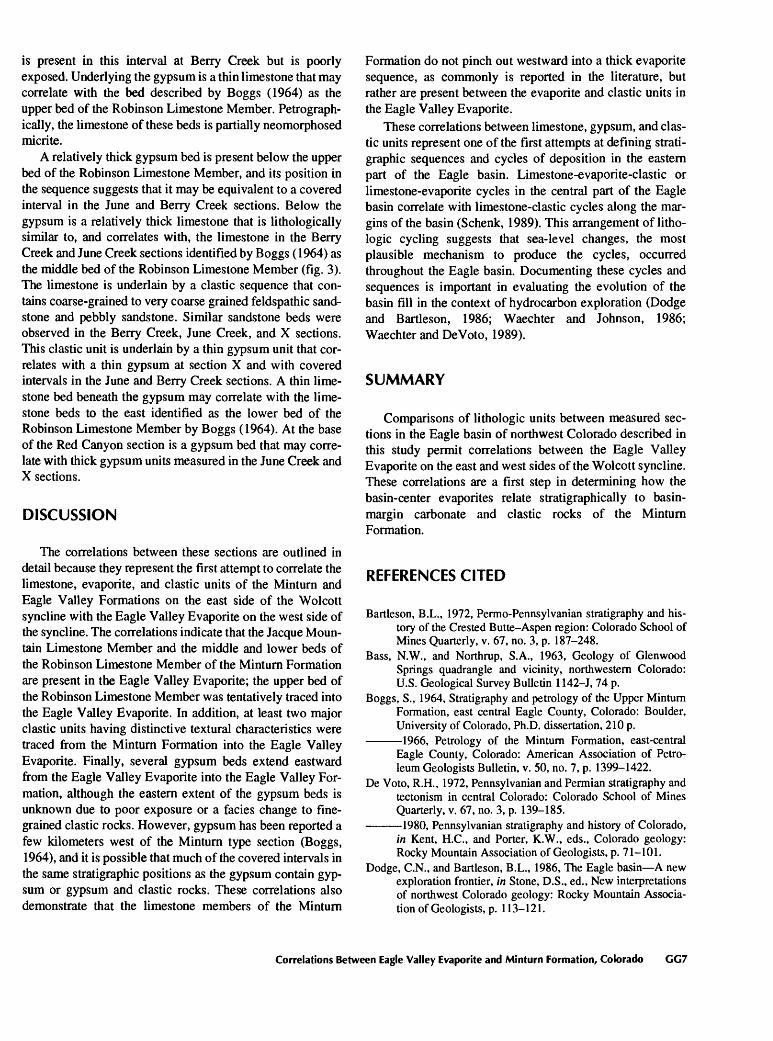
2. Cross section from Eagle to Vail illustrating stratigraphic nomenclature discussed in this report GG3
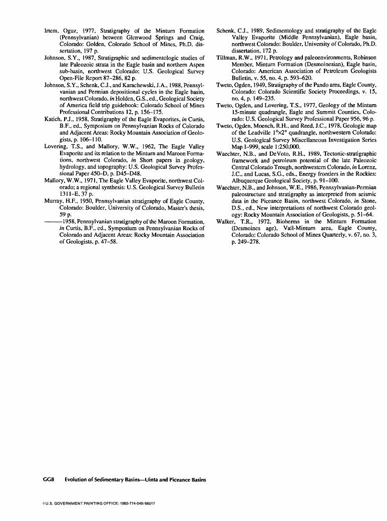
3. Cross section showing correlations between measured sections in the study area GG5
Contents III


EVOLUTION OF SEDIMENTARY BASINS UINTA AND PICEANCE BASINS
Stratigraphic Correlations Between theEagle Valley Evaporite and Minturn Formation,Eagle Basin, Northwest Colorado
By Christopher J. Schenk
Abstract
Six Stratigraphic sections were used to correlate the Mid dle Pennsylvanian Eagle Valley Evaporite in the Eagle basin of northwest Colorado with the Minturn Formation. Correlations within the Eagle Valley sequence are complicated by the Wol- cott syncline, which separates evaporites and clastic rocks of the Eagle Valley Evaporite west of the syncline from predomi nantly clastic units of the Eagle Valley Formation and Minturn Formation east of the syncline.
Correlations of units between measured sections on either side of the syncline indicate that many of the units of the Minturn Formation (or Eagle Valley Formation) described from the area between Minturn and Avon, Colorado, are present in the Eagle Valley Evaporite on the west side of the syncline. The Jacque Mountain Limestone Member and the upper, middle, and lower beds of the Robinson Limestone Member of the Min turn Formation previously have been identified as continuous at least to the eastern edge of the syncline. In this study, the Jacque Mountain and the Robinson were tentatively identified on the west side of the syncline in the Eagle Valley Evaporite and are considered to be members of the Eagle Valley Evapor ite. Three carbonate beds on the west side of the syncline may be the upper, middle, and lower beds of the Robinson Lime stone Member. Several gypsum beds in the Eagle Valley Evaporite probably correlate with gypsum beds on the east side of the syncline, although heavy cover exists on the east side. Two prominent unnamed clastic units of the Minturn Forma tion on the east side of the syncline probably correlate with clastic units of the Eagle Valley Evaporite on the west side of the syncline.
These correlations indicate that the stratigraphy of the Minturn Formation westward from the type section is similar to the stratigraphy of the Eagle Valley Evaporite in the area of the Wolcott syncline. Previous interpretations have suggested that the members of the Minturn Formation pinch out westward into evaporitic rocks.
INTRODUCTION
The purpose of this paper is to describe some strati- graphic correlations between the Middle Pennsylvanian Eagle Valley Evaporite and Minturn Formation in the east ern part of the Eagle basin, northwest Colorado (fig. 1). The eastern part of the Eagle basin, as used in this report, is the area north of the Sawatch uplift and west of the Gore Range. The Eagle Valley Evaporite is a sequence of mudstone, sandstone, gypsum, halite, minor conglomerate, and carbon ate rocks deposited in the central part of the Eagle basin dur ing the Middle Pennsylvanian (Mallory, 1971). Coeval sediments of the Minturn Formation deposited along the northeastern margin of the Eagle basin include sandstone, mudstone, conglomerate, and carbonate rocks. Tweto and others (1978) differentiated the Eagle Valley Evaporite from the Eagle Valley Formation on the basis of the significantly lower evaporite content of the Eagle Valley Formation. They considered the Eagle Valley Formation to be a transi tion between the Eagle Valley Evaporite and the Minturn Formation and mapped the Eagle Valley Formation in the area east of the Wolcott syncline (fig. 1). My studies indi cate, however, that the Eagle Valley Formation probably represents a transition between the Eagle Valley Evaporite and the Maroon Formation rather than the Mintum Forma tion (fig. 2). The Eagle Valley Evaporite was generally mapped west and south of the Wolcott syncline. Boggs (1964,1966) and Tillman (1971), whose work preceded the published map of Tweto and others (1978), considered rocks in the Eagle Valley Formation east of the Wolcott syn cline to be part of the Minturn Formation.
Correlations Between Eagle Valley Evaporite and Minturn Formation, Colorado GG1

106°45' 106°30'
39°45' -
39°30' -
Type section of Eagle Valley Evaporite
Type section of Minturn FormationMinturn .
10 KILOMETERS
EXPLANATION
Eagle Valley Evaporite
Eagle Valley Formation
Minturn Formation
Rocks older than Middle Pennsylvanian Minturn Formation, Eagle Vailey Formation, and Eagle Valley Evaporite
Rocks younger than Middle Pennsylvanian Minturn Formation, Eagle Valley Formation, and Eagle Valley Evaporite
Fault trace
Location of measured section: R, Red Canyon; P, section P; Q, Squaw Creek; BC, Berry Creek; JC, June Creek; X, section X
Figure 1. Geology of the study area and locations of measured sections, eastern part of the Eagle basin, northwest Colorado.
STRATIGRAPHY OF THE MINTURN FORMATION AND EAGLE VALLEY EVAPORITE
The stratigraphy of the Minturn Formation was described by Tweto (1949) and in detail by Tweto and Lovering (1977) from the type section in the vicinity of Minturn, Colorado.
The Minturn Formation is predominantly clastic in composi tion, but it contains several thin limestone beds that have been used as marker horizons in attempts to apply Minturn stratigraphy to areas other than the type section. The Jacque Mountain Limestone and the Robinson Limestone are two members that have been the focus of several stratigraphic studies of the Minturn Formation.
GG2 Evolution of Sedimentary Basins Uinta and Piceance Basins

wEAGLE
WOLCOTT SYNCLINE VAIL
Maroon Formation
Color change
Maroon Formation
Gypsum bed
Eagle Valley Formation (this study)
Jacque Mountain Limestone Member
Eagle Valley Formation of Tweto and others (1978)
White Quail Limestone Member
Eagle Valley Evaporite of Mallory(1971) Elk Ridge Limestone Member
Gypsum bedsRobinson Limestone Member
Figure 2. Cross section from Eagle to Vail, Colorado, illustrating stratigraphic nomenclature discussed in this report. The Eagle Valley Formation probably represents a transition between the Eagle Valley Evaporite and the Maroon Formation. Transition beds above the uppermost gypsum of the Eagle Valley Evaporite in the central part of the Eagle basin were assigned to the Maroon Formation by Bass and Northrup (1963). Datum is the base of the Jacque Mountain Limestone Member of the Minturn Formation.
Clastic rocks of the Eagle Valley Formation generally are yellow, gray, or pale red and contrast markedly with the bright-red and maroon sandstone and mudstone of the over lying Maroon Formation (fig. 2). The color change also sep arates the Minturn Formation from the Maroon Formation in the absence of the Jacque Mountain Limestone (Tweto and others, 1978). The top of the Minturn Formation was origi nally placed at the top of the Jacque Mountain Limestone, which was considered to be the highest marine limestone in the section (Tweto, 1949), but, because the Jacque Mountain Limestone Member could not be traced throughout the Eagle basin, the formation boundary was later redefined as the pro nounced color change (Bartleson, 1972; DeVoto, 1972, 1980). The color change rises stratigraphically toward the center of the basin (Johnson, 1987; Johnson and others, 1988), such that the lower part of the Maroon Formation along the margins of the basin is equivalent to the drab- colored clastic rocks of the Eagle Valley Evaporite and pos sibly the Eagle Valley Formation in the central part of the basin.
The type section of the Eagle Valley Evaporite was defined by Lovering and Mallory (1962) approximately 2
km east of Avon, Colorado, in the Nottingham Creek drain age (fig. 1) and is in the area later mapped as Eagle Valley Formation by Tweto and others (1978). The lower part of the type section is covered by alluvium, and the upper part is almost obscured by slope wash and vegetation. Neverthe less, the type section was established in this area and was illustrated by a panel diagram rather than a stratigraphic- section description (Lovering and Mallory, 1962). A thin limestone bed near the base of the section was interpreted by Lovering and Mallory to be the Jacque Mountain Lime stone Member of the Minturn Formation; thus they claimed to have established the boundary between the Eagle Valley Evaporite and the Maroon Formation in this area. The pres ence of two thin gypsum beds above the limestone led Lovering and Mallory to conclude that the Eagle Valley Evaporite was partly equivalent to both the Minturn and Maroon Formations.
Boggs (1964) carefully traced the Jacque Mountain and Robinson Limestone Members of the Minturn Formation westward from the Minturn Formation type section into the area of the Eagle Valley Evaporite type section. He concluded from a series of closely spaced measured sections
Correlations Between Eagle Valley Evaporite and Minturn Formation, Colorado GC3

that the limestone in the type section of the Eagle Valley Evaporite is the upper bed of the Robinson Member of the Minturn, not the Jacque Mountain Limestone Member. His measured sections show that the Jacque Mountain Lime stone Member is approximately 300 m farther upsection, indicating that the type section of the Eagle Valley Evaporite does not straddle the Maroon Formation boundary as claimed by Levering and Mallory (1962). Mallory (1971) later stated that his work did not substantiate the findings of Boggs (1964).
Boggs (1964), working north of the Eagle River between Avon and Edwards, traced the Jacque Mountain and Robin son Limestone Members westward from the type section of the Eagle Valley Evaporite and followed the Jacque Moun tain Limestone Member and the upper bed of the Robinson Limestone Member as far west as the eastern limb of the Wolcott syncline. He established that these two limestone units could be traced away from the type section of the Minturn Formation, but the Wolcott syncline prevented him from tracing them into the Eagle Valley Evaporite. Many authors had suggested that the limestone members of the Minturn Formation pinch out westward from the Minturn type section into a thick sequence of evaporites (Murray, 1950, 1958; Katich, 1958; Bass and Northrup, 1963; Mallory, 1971; DeVoto, 1972, 1980; Walker, 1972; Irtem, 1977), but Boggs' work demonstrates that the carbonate units extend farther west than previously realized. The westward extent of the limestone units has a greater importance than simply establishing whether or not the beds are traceable; correlations would greatly aid in delineating intervals or cycles of deposition in the central part of the basin and would allow these cycles to be correlated with cycles in clastic sed iments in the Minturn Formation deposited along the mar gins of the Eagle basin, thus providing a framework for determining the evolution of environments across the Eagle basin during Middle Pennsylvanian time.
CORRELATIONS BETWEEN THE EAGLE VALLEY EVAPORITE, EAGLE VALLEY FORMATION, AND THE MINTURN FORMATION
Stratigraphic sections of the upper part of the Eagle Valley Evaporite were measured on the west and east sides of the Wolcott syncline to determine whether the stratigra phy traced to the east side of the syncline by Boggs (1964) could indeed be observed in the Eagle Valley Evaporite on the west side of the syncline. In addition, the June Creek and Berry Creek measured sections of Boggs (1964) were located and restudied in the field, and the limestones in these sections were retraced to the eastern limb of the Wolcott syn cline. It was not difficult to locate and follow the limestone
units described by Boggs, and I concur with his interpreta tion of the position of the Jacque Mountain Limestone Mem ber and the Robinson Limestone Member in this area for the following reasons: (1) his interpretations were based on a series of closely spaced measured sections extending from the type section of the Minturn Formation westward to the Wolcott syncline; (2) his sections can be located, followed, and the limestones retraced; (3) his descriptions of the clastic intervals between the limestones remain consistent within the sequence of limestone beds; and (4) he traced a series of units, not just the Jacque Mountain Limestone Member.
The correlations outlined in this study between the Eagle Valley Evaporite on the west side of the Wolcott syncline and equivalent strata on the east side of the syncline are illus trated in figure 3. Six Stratigraphic sections are presented to illustrate these important correlations: section X, June Creek, Berry Creek, Squaw Creek, and section P on the east side of the Wolcott syncline and Red Canyon on the west side of the syncline. The June Creek and Berry Creek sec tions are from Boggs (1964), and the sections at Squaw Creek and Red Canyon and sections X and P were measured for this study.
Section X
Section X was measured in a draw 0.8 km east of June Creek (fig. 1). The lower bed of the Robinson Limestone Member was traced to this locality from June Creek (see fol lowing section) and provides the basis for correlation. A 7- m-thick gypsum bed is present above the lower bed of the Robinson Limestone (fig. 3). Above the gypsum the slope is mostly covered, but isolated outcrops consist of very coarse to pebbly feldspathic sandstone, as at June Creek to the west. Several gypsum beds are present below the lower bed of the Robinson Limestone Member and are separated by black to gray mudstone and very fine grained sandstone. The strati- graphic intervals containing gypsum at section X are covered at June Creek, suggesting that gypsum is present but not well exposed in this area east of the Wolcott syncline.
June Creek Section
Boggs (1964) followed the Jacque Mountain and Rob inson Limestone Members from the type section of the Minturn Formation westward into the Eagle Valley For mation. At June Creek (fig. 1) he recognized the Jacque Mountain Limestone Member and the upper, middle, and lower beds of the Robinson Limestone Member of the Minturn Formation. Above the Jacque Mountain Lime stone Member is mostly covered slope; between the Jacque Mountain Limestone Member and the upper bed of the Robinson Limestone Member is approximately 200 m of very fine grained to medium-grained sandstone,
CC4 Evolution of Sedimentary Basins Uinta and Piceance Basins

RRED CANYON SE 1/4 sec. 23, NE 1 /4sec. 26, T 4 S, R 84 W
PSECTION P
NE 1 /4sec. 11, T 5 S, R 83 W
QSQUAW CREEK
SEV4 sec. 2, T 5 S, R 83 W
BCBERRY CREEK NE 1 /4sec. 33, T 4 S, R 82 W
JCJUNE CREEK NE1/4S6C. 3,
T 5 S, R 82 W
XSECTION X SWV4 sec. 2, SEV4 sec. 3,
T 5 S, R 82 W
WOLCOTT SYNCLINE
= 1
-11.4km- -0.8 km- -7.7 km- -2.6 km-
EXPLANATIONCoarse-grained, very coarse grained, and
pebbly sandstone
Very fine grained to medium-grained sandstone, minor siltstone, and mudstone
Mudstone
Limestone
Gypsum
Covered interval
-0.9 km H
Upper beds
Middle beds
Lower beds
METERS45 ,
0 '
Figure 3. Correlations between the measured sections in the study area. The Wolcott syncline is between the Red Canyon section and section P. Datum is the base of the Jacque Mountain Limestone Member of the Minturn Formation. Letter above section refers to location of section in figure 1.
mudstone, and thin beds of black limestone. Approxi- The clastic interval below the middle bed of the Robin-mately half of the interval is covered. The interval between the upper and middle beds of the Robinson Limestone Member was described by Boggs as covered.
son Limestone Member contains very fine grained to medium-grained sandstone and mudstone, and coarse grained to very coarse grained feldspathic sandstone and
Correlations Between Eagle Valley Evaporite and Minturn Formation, Colorado GG5

pebbly sandstone; this coarser grained sandstone is uncommon in this part of the Eagle basin. The lower bed of the Robinson Limestone Member underlies this clastic interval. The section below the lower bed of the Robin son Limestone Member is mostly covered but contains the only gypsum bed recognized in this stratigraphic section.
Berry Creek Section
Boggs (1964) identified the Jacque Mountain Limestone Member and the upper, middle, and lower beds of the Rob inson Limestone Member in the vicinity of Berry Creek (fig. 3). The section above the Jacque Mountain Limestone Member is covered. The stratigraphic interval between the Jacque Mountain Limestone Member and the upper bed of the Robinson Limestone Member is composed of very fine grained to medium-grained sandstone and mudstone. Much of the section below the upper bed of the Robinson Lime stone Member is covered, including the interval between the upper and middle beds of the Robinson Limestone Member. The clastic unit between the middle and lower beds of the Robinson Limestone Member, as at June Creek and section X, includes coarse-grained to very coarse grained feldspathic sandstone. Approximately 30 m of the lower part of this section was described by Boggs (1964) as covered, but I observed small, scattered outcrops of gypsum above the lower bed of the Robinson Limestone Member.
Squaw Creek Section
The section at Squaw Creek was measured by Boggs (1964) and remeasured for this study because of its proxim ity to the Wolcott syncline and because it is the westernmost section in which Boggs identified the Jacque Mountain Limestone Member (fig. 3). Approximately 20 m of gypsum is present above the Jacque Mountain Limestone Member at this locality, and the gypsum is overlain by 70 m of covered section. Overlying the covered interval is approximately 60 m of interbedded mudstone, laminated gypsum, and very fine grained sandstone. This is the only section where Boggs described gypsum above the Jacque Mountain Limestone Member; in most of his sections, almost to the type section of the Minturn Formation, he described the interval above the Jacque Mountain Limestone Member as covered. Thus, gypsum may be present above the Jacque Mountain Lime stone Member to the east of Squaw Creek. Below the Jacque Mountain Limestone Member at Squaw Creek is a clastic unit containing very fine grained to medium-grained sand stone and mudstone, similar to the sandstone and mudstone at the same position at Berry and June Creek. The lower boundary of this unit is in fault contact with gypsum.
Section P
Section P is located 1 km west of Squaw Creek (fig. 1), and more of the lower part of the section is exposed here than at Squaw Creek. The Jacque Mountain Limestone Member and the gypsum immediately above it are exposed, as at Squaw Creek. The clastic unit below the Jacque Mountain Limestone Member is composed of very fine grained to medium-grained sandstone and mudstone. Underlying the clastic interval are two thick gypsum beds. I observed a poorly exposed limestone on the slopes between the gypsum beds in this part of the section that possibly cor relates with the upper bed of the Robinson Limestone Member. The gypsum in the lower part of this section is in approximately the same stratigraphic position as a large covered interval in the Berry and June Creek sections. This covered interval is present in each of Boggs' (1964) sections and extends almost to Minturn. Indeed, gypsum is present in this position a few kilometers northwest of Minturn (Boggs, 1964).
Red Canyon Section
The Red Canyon section (fig. 1) on the western limb of the Wolcott syncline provides the important link between the stratigraphy of the Eagle Valley Evaporite on the west side of the syncline and the stratigraphy of the Eagle Valley For mation and Minturn Formation on the east side (fig. 3). It contains the same sequence of limestone, gypsum, and clastic units as the sections on the east side of the syncline. A thin ostrocode-bearing micrite containing phylloid algal fragments underlies the uppermost gypsum and is inter preted to be the Jacque Mountain Limestone Member, based on its presence in a similar sequence of rock types at section P and Squaw Creek.
The gypsum above the Jacque Mountain Limestone Member at Red Canyon is in two massive beds separated by gray to black calcareous mudstone. Very fine grained to fine grained sandstone, mudstone, and thin limestone are present above the gypsum, whereas at Squaw Creek approximately 60 m of mudstone, gypsum, and sandstone are present. This difference suggests that gypsum rises strati graphically to the east in this part of the basin and is intercalated with clastic rocks to the east.
Below the Jacque Mountain Limestone Member at Red Canyon is a thick clastic unit of very fine grained to medium- grained sandstone and mudstone. This interval correlates with similar clastic units below the Jacque Mountain Lime stone Member at four of the sections on the east side of the Wolcott syncline. Underlying the clastic unit are two gyp sum units that probably correlate with gypsum at section P. This gypsum may also be equivalent to the large covered in terval in the Berry Creek and June Creek sections. Gypsum
GG6 Evolution of Sedimentary Basins Uinta and Piceance Basins
is present in this interval at Berry Creek but is poorly exposed. Underlying the gypsum is a thin limestone that may correlate with the bed described by Boggs (1964) as the upper bed of the Robinson Limestone Member. Petrograph- ically, the limestone of these beds is partially neomorphosed micrite.
A relatively thick gypsum bed is present below the upper bed of the Robinson Limestone Member, and its position in the sequence suggests that it may be equivalent to a covered interval in the June and Berry Creek sections. Below the gypsum is a relatively thick limestone that is lithologically similar to, and correlates with, the limestone in the Berry Creek and June Creek sections identified by Boggs (1964) as the middle bed of the Robinson Limestone Member (fig. 3). The limestone is underlain by a clastic sequence that con tains coarse-grained to very coarse grained feldspathic sand stone and pebbly sandstone. Similar sandstone beds were observed in the Berry Creek, June Creek, and X sections. This clastic unit is underlain by a thin gypsum unit that cor relates with a thin gypsum at section X and with covered intervals in the June and Berry Creek sections. A thin lime stone bed beneath the gypsum may correlate with the lime stone beds to the east identified as the lower bed of the Robinson Limestone Member by Boggs (1964). At the base of the Red Canyon section is a gypsum bed that may corre late with thick gypsum units measured in the June Creek and X sections.
DISCUSSION
The correlations between these sections are outlined in detail because they represent the first attempt to correlate the limestone, evaporite, and clastic units of the Minturn and Eagle Valley Formations on the east side of the Wolcott syncline with the Eagle Valley Evaporite on the west side of the syncline. The correlations indicate that the Jacque Moun tain Limestone Member and the middle and lower beds of the Robinson Limestone Member of the Minturn Formation are present in the Eagle Valley Evaporite; the upper bed of the Robinson Limestone Member was tentatively traced into the Eagle Valley Evaporite. In addition, at least two major clastic units having distinctive textural characteristics were traced from the Minturn Formation into the Eagle Valley Evaporite. Finally, several gypsum beds extend eastward from the Eagle Valley Evaporite into the Eagle Valley For mation, although the eastern extent of the gypsum beds is unknown due to poor exposure or a facies change to fine grained clastic rocks. However, gypsum has been reported a few kilometers west of the Minturn type section (Boggs, 1964), and it is possible that much of the covered intervals in the same stratigraphic positions as the gypsum contain gyp sum or gypsum and clastic rocks. These correlations also demonstrate that the limestone members of the Minturn
Formation do not pinch out westward into a thick evaporite sequence, as commonly is reported in the literature, but rather are present between the evaporite and clastic units in the Eagle Valley Evaporite.
These correlations between limestone, gypsum, and clas tic units represent one of the first attempts at defining strati- graphic sequences and cycles of deposition in the eastern part of the Eagle basin. Limestone-evaporite-clastic or limestone-evaporite cycles in the central part of the Eagle basin correlate with limestone-clastic cycles along the mar gins of the basin (Schenk, 1989). This arrangement of litho- logic cycling suggests that sea-level changes, the most plausible mechanism to produce the cycles, occurred throughout the Eagle basin. Documenting these cycles and sequences is important in evaluating the evolution of the basin fill in the context of hydrocarbon exploration (Dodge and Bartleson, 1986; Waechter and Johnson, 1986; Waechter and DeVoto, 1989).
SUMMARY
Comparisons of lithologic units between measured sec tions in the Eagle basin of northwest Colorado described in this study permit correlations between the Eagle Valley Evaporite on the east and west sides of the Wolcott syncline. These correlations are a first step in determining how the basin-center evaporites relate stratigraphically to basin- margin carbonate and clastic rocks of the Minturn Formation.
REFERENCES CITED
Bartleson, B.L., 1972, Permo-Pennsylvanian stratigraphy and his tory of the Crested Butte-Aspen region: Colorado School of Mines Quarterly, v. 67, no. 3, p. 187-248.
Bass, N.W., and Northrup, S.A., 1963, Geology of Glenwood Springs quadrangle and vicinity, northwestern Colorado: U.S. Geological Survey Bulletin 1142-J, 74 p.
Boggs, S., 1964, Stratigraphy and petrology of the Upper Minturn Formation, east central Eagle County, Colorado: Boulder, University of Colorado, Ph.D. dissertation, 210 p.
1966, Petrology of the Minturn Formation, east-central Eagle County, Colorado: American Association of Petro leum Geologists Bulletin, v. 50, no. 7, p. 1399-1422.
De Voto, R.H., 1972, Pennsylvanian and Permian stratigraphy and tectonism in central Colorado: Colorado School of Mines Quarterly, v. 67, no. 3, p. 139-185.
1980, Pennsylvanian stratigraphy and history of Colorado, in Kent, H.C., and Porter, K.W., eds., Colorado geology: Rocky Mountain Association of Geologists, p. 71-101.
Dodge, C.N., and Bartleson, B.L., 1986, The Eagle basin A new exploration frontier, in Stone, D.S., ed., New interpretations of northwest Colorado geology: Rocky Mountain Associa tion of Geologists, p. 113-121.
Correlations Between Eagle Valley Evaporite and Minturn Formation, Colorado GG7
Irtem, Oguz, 1977, Stratigraphy of the Minturn Formation (Pennsylvanian) between Glenwood Springs and Craig, Colorado: Golden, Colorado School of Mines, Ph.D. dis sertation, 197 p.
Johnson, S.Y., 1987, Stratigraphic and sedimentologic studies of late Paleozoic strata in the Eagle basin and northern Aspen sub-basin, northwest Colorado: U.S. Geological Survey Open-File Report 87-286, 82 p.
Johnson, S.Y., Schenk, C.J., and Karachewski, J.A., 1988, Pennsyl vanian and Permian depositional cycles in the Eagle basin, northwest Colorado, in Holden, G.S., ed., Geological Society of America field trip guidebook: Colorado School of Mines Professional Contributions 12, p. 156-175.
Katich, P.J., 1958, Stratigraphy of the Eagle Evaporites, in Curtis, B.F., ed., Symposium on Pennsylvanian Rocks of Colorado and Adjacent Areas: Rocky Mountain Association of Geolo gists, p. 106-110.
Levering, T.S., and Mallory, W.W., 1962, The Eagle Valley Evaporite and its relation to the Minturn and Maroon Forma tions, northwest Colorado, in Short papers in geology, hydrology, and topography: U.S. Geological Survey Profes sional Paper 450-D, p. D45-D48.
Mallory, W.W., 1971, The Eagle Valley Evaporite, northwest Col orado; a regional synthesis: U.S. Geological Survey Bulletin 1311-E,37p.
Murray, H.F., 1950, Pennsylvanian stratigraphy of Eagle County, Colorado: Boulder, University of Colorado, Master's thesis, 59 p.
1958, Pennsylvanian stratigraphy of the Maroon Formation, in Curtis, B.F., ed., Symposium on Pennsylvanian Rocks of Colorado and Adjacent Areas: Rocky Mountain Association of Geologists, p. 47-58.
Schenk, C.J., 1989, Sedimentology and stratigraphy of the Eagle Valley Evaporite (Middle Pennsylvanian), Eagle basin, northwest Colorado: Boulder, University of Colorado, Ph.D. dissertation, 172 p.
Tillman, R.W., 1971, Petrology and paleoenvironments, Robinson Member, Minturn Formation (Desmoinesian), Eagle basin, Colorado: American Association of Petroleum Geologists Bulletin, v. 55, no. 4, p. 593-620.
Tweto, Ogden, 1949, Stratigraphy of the Pando area, Eagle County, Colorado: Colorado Scientific Society Proceedings, v. 15, no. 4, p. 149-235.
Tweto, Ogden, and Lovering, T.S., 1977, Geology of the Minturn 15-minute quadrangle, Eagle and Summit Counties, Colo rado: U.S. Geological Survey Professional Paper 956,96 p.
Tweto, Ogden, Moench, R.H., and Reed, J.C., 1978, Geologic map of the Leadville I°x2° quadrangle, northwestern Colorado: U.S. Geological Survey Miscellaneous Investigation Series Map 1-999, scale 1:250,000.
Waechter, N.B., and DeVoto, R.H., 1989, Tectonic-stratigraphic framework and petroleum potential of the late Paleozoic Central Colorado Trough, northwestern Colorado, in Lorenz, J.C., and Lucas, S.G., eds., Energy frontiers in the Rockies: Albuquerque Geological Society, p. 91-100.
Waechter, N.B., and Johnson, W.E., 1986, Pennsylvanian-Permian paleostructure and stratigraphy as interpreted from seismic data in the Piceance Basin, northwest Colorado, in Stone, D.S., ed., New interpretations of northwest Colorado geol ogy: Rocky Mountain Association of Geologists, p. 51-64.
Walker, T.R., 1972, Bioherms in the Minturn Formation (Desmoines age), Vail-Minturn area, Eagle County, Colorado: Colorado School of Mines Quarterly, v. 67, no. 3, p. 249-278.
GG8 Evolution of Sedimentary Basins Uinta and Piceance Basins
AU.S. GOVERNMENT PRINTING OFFICE: 1992-774-049/66017

SELECTED SERIES OF U.S. GEOLOGICAL SURVEY PUBLICATIONS
Periodicals
Earthquakes & Volcanoes (issued bimonthly). Preliminary Determination of Epicenters (issued monthly).
Technical Books and Reports
Professional Papers are mainly comprehensive scientific reports of wide and lasting interest and importance to professional scientists and engineers. Included are reports on the results of resource studies and of topographic, hydrologic, and geologic investigations. They also include collections of related papers addressing different aspects of a single sci entific topic.
Bulletins contain significant data and interpretations that are of lasting scientific interest but are generally more limited in scope or geo graphic coverage than Professional Papers. They include the results of resource studies and of geologic and topographic investigations; as well as collections of short papers related to a specific topic.
Water-Supply Papers are comprehensive reports that present sig nificant interpretive results of hydrologic investigations of wide interest to professional geologists, hydrologists, and engineers. The series covers investigations in all phases of hydrology, including hydrology, availabil ity of water, quality of water, and use of water.
Circulars present administrative information or important scientif ic information of wide popular interest in a format designed for distribu tion at no cost to the public. Information is usually of short-term interest.
Water-Resources Investigations Reports are papers of an inter pretive nature made available to the public outside the formal USGS pub lications series. Copies are reproduced on request unlike formal USGS publications, and they are also available for public inspection at deposi tories indicated in USGS catalogs.
Open-File Reports include unpublished manuscript reports, maps, and other material that are made available for public consultation at de positories. They are a nonpermanent form of publication that maybe cit ed in other publications as sources of information.
MapsGeologic Quadrangle Maps are multicolor geologic maps on to
pographic bases in 7 1/2- or 15-minute quadrangle formats (scales main ly 1:24,000 or 1:62,500) showing bedrock, surficial, or engineering geology. Maps generally include brief texts; some maps include structure and columnar sections only.
Geophysical Investigations Maps are on topographic or planimet- ric bases at various scales, they show results of surveys using geophysi cal techniques, such as gravity, magnetic, seismic, or radioactivity, which reflect subsurface structures that are of economic or geologic signifi cance. Many maps include correlations with the geology.
Miscellaneous Investigations Series Maps are on planimetric or topographic bases of regular and irregular areas at various scales; they present a wide variety of format and subject matter. The series also in cludes 7 1/2-minute quadrangle photogeologic maps on planimetric bases which show geology as interpreted from aerial photographs. The series also includes maps of Mars and the Moon.
Coal Investigations Maps are geologic maps on topographic or planimetric bases at various scales showing bedrock or surficial geology, stratigraphy, and structural relations in certain coal-resource areas.
Oil and Gas Investigations Charts show stratigraphic informa tion for certain oil and gas fields and other areas having petroleum poten tial.
Miscellaneous Field Studies Maps are multicolor or black-and- white maps on topographic or planimetric bases on quadrangle or irreg ular areas at various scales. Pre-1971 maps show bedrock geology in re lation to specific mining or mineral-deposit problems; post-1971 maps are primarily black-and-white maps on various subjects such as environ mental studies or wilderness mineral investigations.
Hydrologic Investigations Atlases are multicolored or black-and- white maps on topographic or planimetric bases presenting a wide range of geohydrologic data of both regular and irregular areas; the principal scale is 1:24,000, and regional studies are at 1:250,000 scale or smaller.
Catalogs
Permanent catalogs, as well as some others, giving comprehensive listings of U.S. Geological Survey publications are available under the conditions indicated below from the U.S. Geological Survey, Books and Open-File Reports Sales, Box 25286, Denver, CO 80225. (See latest Price and Availability List.)
"Publications of the Geological Survey, 1879-1961" may be pur chased by mail and over the counter in paperback book form and as a set microfiche.
"Publications of the Geological Survey, 1962-1970" may be pur chased by mail and over the counter in paperback book form and as a set of microfiche.
"Publications of the U.S. Geological Survey, 1971-1981" may be purchased by mail and over the counter in paperback book form (two volumes, publications listing and index) and as a set of microfiche.
Supplements for 1982, 1983, 1984, 1985, 1986, and for subse quent years since the last permanent catalog may be purchased by mail and over the counter in paperback book form.
State catalogs, "List of U.S. Geological Survey Geologic and Wa ter-Supply Reports and Maps For (State)," may be purchased by mail and over the counter in paperback booklet form only.
"Price and Availability List of U.S. Geological Survey Publica tions," issued annually, is available free of charge in paperback booklet form only.
Selected copies of a monthly catalog "New Publications of the U.S. Geological Survey" is available free of charge by mail or may be obtained over the counter in paperback booklet form only. Those wishing a free subscription to the monthly catalog "New Publications of the U.S. Geological Survey" should write to the U.S. Geological Survey, 582 Na tional Center, Reston, VA 22092.
Note.-Prices of Government publications listed in older catalogs, announcements, and publications may be incorrect. Therefore, the prices charged may differ from the prices in catalogs, announcements, and pub lications.