Embed Size (px)
Citation preview

ClickHere
for
FullArticle
Structural complexity resulting from pervasive ductiledeformation in the Karakoram Shear Zone, Ladakh, NW India
M. R. McCarthy1 and R. F. Weinberg1
Received 21 July 2008; revised 5 October 2009; accepted 23 November 2009; published 19 May 2010.
[1] The NW‐SE trending, ∼800 km long, dextralKarakoram Shear Zone bounds southwest Tibet. Weinvestigate an area immediately NW of the PangongLake where midcrustal rocks sections of the shear zoneare exposed. Here, the dominant shear zone is charac-terized by dextral mylonitic rocks sheared at amphibo-lite facies and partly retrogressed to greenschist facies.These rocks define a kilometric, SE plunging inclined‐to‐recumbent fold in the footwall of a north directed,oblique dextral thrust that exhumed anatectic rocks ofthe Pangong Range. Argon cooling ages reveal thatthe Pangong Range cooled from ∼700°C to 300°C be-tween ∼18–15 and ∼10 Ma, contemporaneously withoverthrusting. Toward the SE, closer to the PangongLake, this kilometric fold is rotated from its NW–SEtrend to an E–W trend, and the sense of shear changesto sinistral, with a broadly north directed thrusting com-ponent. The documented structures contradict predic-tions of normal movement in this area derived fromconsiderations of rigid block behavior of the crustand support the interpretation that the system recordsdextral transpression. Thrusting and exhumation ofthe deeper and hot rocks exposed in the PangongRange, folding of the thrust footwall, and the develop-ment of a sinistral E–W trending shear zone are allcompatible with transpression caused by a northwardpush by a rigid indenter such as the Ladakh Batholith.Citation: McCarthy, M. R., and R. F. Weinberg (2010),Structural complexity resulting from pervasive ductile deformationin the Karakoram Shear Zone, Ladakh, NW India, Tectonics, 29,TC3004, doi:10.1029/2008TC002354.
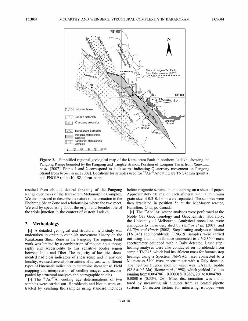
1. Introduction[2] The Karakoram Shear Zone is a ∼800 km long, dextral
strike‐slip fault bounding the southwestern margin of Tibet(Figure 1). Various aspects of the Karakoram Shear Zoneincluding age of initiation, slip rates, and finite geologicaloffsets remain controversial. Interpretations vary greatlydepending on correlation of offset geological features acrossthe shear zone and their age, as well as the age of the shearzone [Lacassin et al., 2004a; Peltzer and Tapponnier, 1988;
Rolland et al., 2009; Searle, 1996; Searle et al., 1998;Searle and Phillips, 2004; Upadhyay et al., 2005; Valli etal., 2007, 2008; Weinberg and Dunlap, 2000]. Totalmovement on the fault has been estimated variously to bebetween 40 and 150 km [Searle and Phillips, 2007], aminimum of 250 km [Lacassin et al., 2004a, 2004b; Valli etal., 2008], or around 300 km either on the Karakoram Faultitself [Rolland et al., 2009] or distributed over a wide zoneof deformation [Weinberg and Dunlap, 2000]. Estimates ofthe age of initiation of the shear zone also vary from 23 Ma(possibly as old as 34Ma) [Lacassin et al., 2004a; Valli et al.,2007, 2008; Weinberg and Dunlap, 2000] to 18 ± 0.6 Ma[Searle et al., 1998] or as young as 15.7 Ma [Phillips et al.,2004; Phillips and Searle, 2007] or 13.9 ± 0.1 Ma [Bhutaniet al., 2003]. Correspondingly, calculated slip rates rangefrom around 3–5 mm/yr [Brown et al., 2002; Wright et al.,2004] to 10 mm/yr [Chevalier et al., 2005; Lacassin et al.,2004a].[3] A number of studies have focused on the structural
and metamorphic characterization of the shear zone[Lacassin et al., 2004a; Murphy et al., 2000, 2002; Murphyand Burgess, 2006; Phillips and Searle, 2007; Ravikant,2006; Rolland and Pêcher, 2001; Rolland et al., 2009;Rutter et al., 2007; Valli et al., 2007, 2008; Weinberg et al.,2000], but information regarding the temporal and spatialstructural evolution is lacking over large portions of theshear zone. On the basis of remote sensing studies,Raterman et al. [2007] defined a triple junction in a remoteand currently inaccessible part of Karakoram mountains inLadakh. In this area, the dextral Karakoram Shear Zone isinterpreted to intersect the sinistral, E–W trending, LongmuTso Fault (Figure 1). This fault is part of a system of faultsthat link up with the sinistral Altyn Tagh Fault, anothermajor transcurrent fault bounding the Tibetan Plateau.Raterman et al. defined a 27 km wide bend of the Kar-akoram Shear Zone (Figure 2), where it curves around theNE margin of Pangong Range, and ascribed the bend tocontemporaneous sinistral motion on the Longmu Tso Fault,which would impose transtension south of the junction.Using a rigid block conceptualization of continental crustdeformation and using estimates for current movement rateson the fault system, they carried out kinematic analysiswhich supported transtension in the area of the PangongRange, south of the bend, and allowed for an estimate of therate of lateral movement that created the bend. This inter-pretation contrasts with the structural study of Weinberg etal. [2000], who interpreted the Pangong Range as an ex-humed pop‐up block of migmatites resulting from trans-pression between two strands of the Karakoram ShearZone: the NE Pangong Strand and the SW Tangtse Strand(Figure 2). They found no evidence for transtension in the area.
1School of Geosciences, Monash University, Clayton, Victoria,Australia.
Copyright 2010 by the American Geophysical Union.0278‐7407/10/2008TC002354
TECTONICS, VOL. 29, TC3004, doi:10.1029/2008TC002354, 2010
TC3004 1 of 18

[4] Understanding the nature of deformation in this regionwhere the Karakoram Shear Zone links up with the sinistralsystem that ultimately focus into the Altyn Tagh Fault(Figure 1) may help us to better constrain the balance be-tween pervasive deformation and rigid block translationduring continental collision. In this paper we investigate thestructural and metamorphic evolution of a triple junction inthe Pangong Tso (Pangong lake). This junction is 40 km
south of and similar to that defined by Raterman et al.[2007]. In the Pangong Tso area, the NE Pangong Strandof the Karakoram Shear Zone intersects the newly definedE–W trending sinistral Phobrang Shear Zone (Figure 2).[5] This paper starts with a brief section on methodology,
followed by a description of the deformation related to theKarakoram Shear Zone, away from this newly defined triplejunction. Here, a kilometric‐scale fold of mylonitic rocks
Figure 1. Map of the Karakoram fault system, showing adjacent major structures in western Himalayas.Modified from Searle et al. [1998].
MCCARTHY AND WEINBERG: STRUCTURAL COMPLEXITY IN KARAKORAM TC3004TC3004
2 of 18
resulted from oblique dextral thrusting of the PangongRange over rocks of the Karakoram Metamorphic Complex.We then proceed to describe the nature of deformation in thePhobrang Shear Zone and relationships where the two meet.We end by speculating about the origin and broader role ofthe triple junction in the context of eastern Ladakh.
2. Methodology[6] A detailed geological and structural field study was
undertaken in order to establish movement history on theKarakoram Shear Zone in the Pangong Tso region. Fieldwork was limited by a combination of mountainous topog-raphy and accessibility to this sensitive border regionbetween India and Tibet. The majority of localities docu-mented had clear indicators of shear sense and in any onelocality, we used several observations of at least two differenttypes of kinematic indicators to determine shear sense. Fieldmapping and interpretation of satellite images was accom-panied by structural analyses and petrographic studies.[7] The 40Ar/39Ar cooling age determinations of two
samples were carried out. Hornblende and biotite were ex-tracted by crushing the samples using standard methods
before magnetic separation and tapping on a sheet of paper.Approximately 50 mg of each mineral with a minimumgrain size of 0.3–0.1 mm were separated. The samples werethen irradiated in position 5c at the McMaster reactor,Hamilton, Ontario, Canada.[8] The 40Ar/39Ar isotope analyses were performed at the
Noble Gas Geochronology and Geochemistry laboratory,the University of Melbourne. Analytical procedures wereanalogous to those described by Phillips et al. [2007] andPhillips and Harris [2008]. Step‐heating analyses of biotite(TNG45) and hornblende (TNG19) samples were carriedout using a tantalum furnace connected to a VG3600 massspectrometer equipped with a Daly detector. Laser step‐heating analyses were also conducted on hornblende fromsample TNG45, which had insufficient mass for furnace stepheating, using a Spectron Nd‐YAG laser connected to aMicromass 5400 mass spectrometer with a Daly detector.The neutron fluence monitor used was GA1550 biotite(98.8 ± 0.5 Ma) [Renne et al., 1998], which yielded J valuesranging from 0.004786 ± 0.000018 (0.38%, 2s) to 0.004789 ±0.000016 (0.33%, 2s). Mass discrimination was moni-tored by measuring air aliquots from calibrated pipettesystems. Correction factors for interfering isotopes were
Figure 2. Simplified regional geological map of the Karakoram Fault in northern Ladakh, showing thePangong Range bounded by the Pangong and Tangtse strands. Position of Longmu Tso is from Ratermanet al. [2007]. Points 1 and 2 correspond to fault scarps indicating Quaternary movement on PangongStrand from Brown et al. [2002]. Locations for samples used for 40Ar/39Ar dating are TNG45mm (point a)and PNG19 (point b). SZ, shear zone.
MCCARTHY AND WEINBERG: STRUCTURAL COMPLEXITY IN KARAKORAM TC3004TC3004
3 of 18
(39Ar/37Ar)Ca = 6.80 (±0.05), × 10−4; (36Ar/37Ar)Ca = 2.89(±0.19) × 10−4 and (40Ar/39Ar)K = 4.0 (±4.0) × 10−4. Ageplateaus are defined as including ≥ 50% of 39Ar, dis-tributed over a minimum of 3 consecutive steps and coinci-dent at the 95% confidence level.
3. Geological Setting3.1. Regional Geology
[9] The Karakoram Shear Zone extends along the south-western margin of Tibet from its northern termination at thetranstensional Muji basin in the central Pamir region, to thesouthern termination in the Mount Kailas region [Murphy etal., 2002] (Figure 1). The central segment of the fault ischaracterized by transpressional ranges such as the PangongRange and K2‐Gasherbrum Range [Searle et al., 1998],where deeper crustal rocks have been exhumed.[10] In Ladakh, the Pangong Range is bounded by the
active northeastern Pangong Strand of the Karakoram Shear
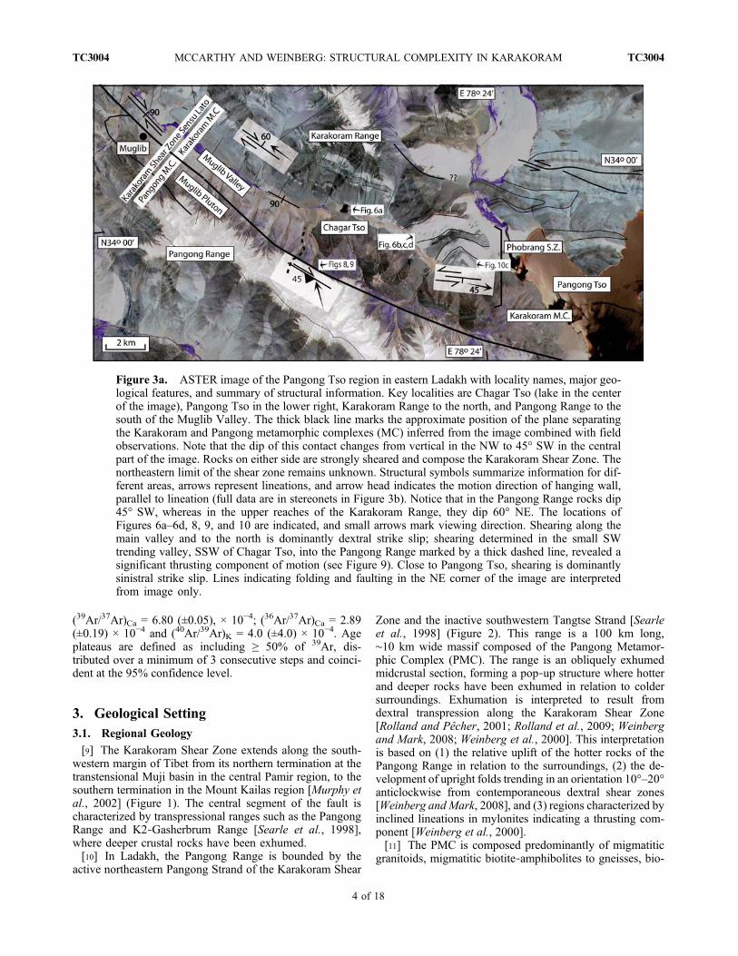
Zone and the inactive southwestern Tangtse Strand [Searleet al., 1998] (Figure 2). This range is a 100 km long,∼10 km wide massif composed of the Pangong Metamor-phic Complex (PMC). The range is an obliquely exhumedmidcrustal section, forming a pop‐up structure where hotterand deeper rocks have been exhumed in relation to coldersurroundings. Exhumation is interpreted to result fromdextral transpression along the Karakoram Shear Zone[Rolland and Pêcher, 2001; Rolland et al., 2009; Weinbergand Mark, 2008; Weinberg et al., 2000]. This interpretationis based on (1) the relative uplift of the hotter rocks of thePangong Range in relation to the surroundings, (2) the de-velopment of upright folds trending in an orientation 10°–20°anticlockwise from contemporaneous dextral shear zones[Weinberg and Mark, 2008], and (3) regions characterized byinclined lineations in mylonites indicating a thrusting com-ponent [Weinberg et al., 2000].[11] The PMC is composed predominantly of migmatitic
granitoids, migmatitic biotite‐amphibolites to gneisses, bio-
Figure 3a. ASTER image of the Pangong Tso region in eastern Ladakh with locality names, major geo-logical features, and summary of structural information. Key localities are Chagar Tso (lake in the centerof the image), Pangong Tso in the lower right, Karakoram Range to the north, and Pangong Range to thesouth of the Muglib Valley. The thick black line marks the approximate position of the plane separatingthe Karakoram and Pangong metamorphic complexes (MC) inferred from the image combined with fieldobservations. Note that the dip of this contact changes from vertical in the NW to 45° SW in the centralpart of the image. Rocks on either side are strongly sheared and compose the Karakoram Shear Zone. Thenortheastern limit of the shear zone remains unknown. Structural symbols summarize information for dif-ferent areas, arrows represent lineations, and arrow head indicates the motion direction of hanging wall,parallel to lineation (full data are in stereonets in Figure 3b). Notice that in the Pangong Range rocks dip45° SW, whereas in the upper reaches of the Karakoram Range, they dip 60° NE. The locations ofFigures 6a–6d, 8, 9, and 10 are indicated, and small arrows mark viewing direction. Shearing along themain valley and to the north is dominantly dextral strike slip; shearing determined in the small SWtrending valley, SSW of Chagar Tso, into the Pangong Range marked by a thick dashed line, revealed asignificant thrusting component of motion (see Figure 9). Close to Pangong Tso, shearing is dominantlysinistral strike slip. Lines indicating folding and faulting in the NE corner of the image are interpretedfrom image only.
MCCARTHY AND WEINBERG: STRUCTURAL COMPLEXITY IN KARAKORAM TC3004TC3004
4 of 18

Figure 3b
MCCARTHY AND WEINBERG: STRUCTURAL COMPLEXITY IN KARAKORAM TC3004TC3004
5 of 18

tite schists and psammites, calc‐silicate rocks and leuco-granite intrusions [Weinberg andMark, 2008]. Leucogranitesin the Pangong Range have been dated to between 20 and15 Ma [e.g., Reichardt et al., 2010; Searle et al., 1998]. TheLadakh terrane lies to the southwest of the Karakoram ShearZone and consists predominantly of precollisional calc‐al-kaline rocks forming the Ladakh Batholith, and the associatedKhardung volcanic rocks (Figure 2), which were a part of theCretaceous Kohistan‐Ladakh island arc [Weinberg andDunlap, 2000]. Step heating Ar isotope experiments inK‐feldspar from a sample collected in the vicinity of theKarakoram Shear Zone in Ladakh indicates that at leastparts of the batholith have remained at temperatures below
150°C since 36 Ma, that is, since before anatexis in theKarakoram Shear Zone [Dunlap et al., 1998].[12] The Karakoram terrane is located northeast of the
Karakoram Shear Zone and consists in this area of Paleo-zoic‐Mesozoic sedimentary rocks of the Asian plate knownas the Karakoram Metamorphic Complex (KMC). We fol-low the literature and ascribe to the KMC a package of rockscomposed predominantly of garnet‐biotite‐staurolite schists,marbles, amphibolites, calc‐schists, and quartzo‐feldspathicmica schists grading to psammites [Dunlap et al., 1998],including a bedding‐parallel leucogranite sheet, modally andtexturally similar to those that form the bulk of the Kar-akoram Batholith in Ladakh [Weinberg and Mark, 2008].
Figure 4. (a) Banded sheared marble. More competent, quartz‐rich bands deformed into asymmetriclenses by dextral shearing. (b) Steep wall parallel to layering in marble showing the strong pervasive lin-eation that characterizes nearly all rock types in the area. Lineation plunging gently to the SE; pen forscale is nearly horizontal. (c) Leucogranite mylonite. (d) Pegmatitic leucogranite and mafic band withK‐feldspar porphyroclasts, outcrop surface perpendicular to foliation parallel to lineation. (e) Shear foldin leucogranite mylonite in contact with amphibolite mylonite, looking down plunge of the lineation. Allphotographs are from outcrops immediately NW of Chagar Tso.
Figure 3b. Geological and structural map, showing two structural domains separated by the bold, NW–SE trending dashedline. The northern Karakoram Shear Zone (or Muglib) domain is characterized by dextral shearing on a NW–SE trendingfabric. In the southern Phobrang Shear Zone (or Pangong) domain the fabric rotates to close to E–W. Equal‐area, lower hemi-sphere stereographic projections of C planes and lineations for different areas. A‐A′, B‐B′, C‐C′, D‐D′ mark the position ofcross sections used to construct Figure 7. Widespread and well‐defined dextral shear indicators characterize the northernMuglib domain, whereas sinistral shear indicators characterize the southern Pangong domain (shear senses not marked onmap). A zone of ambiguous or coexisting sinistral and dextral indicators define a transition zone between the two domains.Dashed box on west side marks region between KarakoramMetamorphic Complex, characterized by interlayered marble andmetapelites, and Pangong Metamorphic Complex, characterized by anatectic schists in contact with Muglib Batholith.
MCCARTHY AND WEINBERG: STRUCTURAL COMPLEXITY IN KARAKORAM TC3004TC3004
6 of 18

The KMC differs from the PMC by the presence of thicklayers of marble and rarity of leucogranites. Also, KMCrocks underwent only lower amphibolite to greenschistfacies metamorphism and therefore lack migmatites.
3.2. Geology of the Muglib Valley in the Pangong TsoRegion
[13] The Muglib Valley, along the NE side of the PangongRange, trends northwest‐southeast for ∼30 km (Figure 2)from the northern tip of the Pangong Tso, a drowned rivervalley dammed by tectonic uplift at its northwestern end as aresult of recent movement on the Pangong Strand [Searle etal., 1998]. We focus on a region immediately northwest ofthe lake (Figures 3a and 3b), where rocks exposed in thevalley and to the north are part of the Karakoram Metamor-phic Complex and consist predominantly of recrystallizedmassive marble units, pelitic and psammitic schists, quart-zites and amphibolites, with many of the lithologies showingextensive interlayering, likely to be a combined result ofprimary bedding and shearing. The sequence is stronglysheared into protomylonites to mylonites with well‐developed mineral and stretching lineations [see also Rollandet al., 2009].[14] The marble units, which stand out in the sequence,
form layers up to ∼700 m thick, range from a creamy sandy‐pink to dark blue‐gray quartz‐rich beds, medium‐coarsegrained, mostly massive but with faint banding parallel tocontacts apparent in some areas, possibly representing relictbedding. In the darker, brown, contaminated marbles andblue‐gray quartz‐rich marbles, shearing is defined by de-formation of more competent bands (Figure 4a). In themassive marbles, the mylonitic fabric is represented bywell‐defined color banding and strong stretching lineation(Figure 4b), with rare intrafolial isoclinal folds parallel toregional fabric.
[15] The most distinctive unit in the sequence is a singleband of mylonitic leucogranite up to 200 m wide in placesand parallel to bedding (Figures 4c–4e). The presence offeldspar porphyroclasts up to 2 cm in size in a finer grainedmatrix of quartz, feldspar, muscovite and biotite ± garnetsuggests it was a pegmatitic leucogranite. It is interlayeredwith bands and pods of amphibolite, typically <1 m thick(Figure 4c).[16] There are a number of banded units up to tens of
meters thick, within and between the massive marble beds(Figures 3a and 3b). These consist of interlayered marble ±amphibolite ± schists (Figure 5), with both continuous andlenticular bands ranging in width from <20 cm to 1 m. Theamphibolite units, present as a continuous band up to 60 mthick, as well as thin layers in banded sequences, are fine‐grained consisting predominantly of hornblende, biotite,plagioclase, minor quartz, and garnet, retrogressed in thesouthern part of the valley to tremolite‐actinolite + chlorite+ calcite representing a greenschist facies paragenesis.[17] There are a number of biotite schist layers in the area,
ranging in composition from quartz and feldspar‐richpsammitic schists, to muscovite and biotite‐rich schists in-cluding garnet in places, and minor sillimanite [Rolland etal., 2009]. These layers range in thickness from tens ofmeters up to 300–400 m thick. Chlorite schists in Figures 3aand 3b represent a greenschist facies retrogression of theamphibolite facies assemblages and dominate the south andsouthwestern part of the valley (Figures 3a and 3b). Retro-gression is gradational, first appearing as narrow bands ofchlorite schist surrounding quartz veins in amphibolites.Retrogression increases in intensity southward into thePangong Range, where the alteration is pervasive, re-presented by chlorite‐actinolite‐calcite schists with euhedralpyrite and magnetite grains up to 1 cm in size.
4. Structural Geology4.1. General Features
[18] Although our focus is the dominant ductile defor-mation there is evidence for local brittle deformation [e.g.,Rutter et al., 2007], such as brecciation of the marblesoutheast of Chagar Tso or Chagar lake (Figures 3a and 3b).This brecciated unit is ∼40 m thick, with clasts ranging fromlarge subrounded blocks to smaller, angular blocks withjigsaw fit in fine‐grained calcite cement. Fault planes withbrecciated marble were documented throughout the fieldarea, commonly trending NNE–SSW parallel to some of thedeeper valleys in the ranges. Within the same marble unit,∼4 km ESE of “a” in Figure 2, the marble exposed in a roadcut is faulted and folded (“b” in Figure 2). The fault,traceable for ∼30 m, dips moderately toward the SSW,thrusting large open folds over tight asymmetric foldsplunging shallowly ∼ WNW. Generally, however, detailedmapping revealed that the extent of brittle deformation inthe area is limited, with layers preserving continuity acrossthe map (Figure 3b).[19] Rocks in the region have undergone intense ductile
deformation, with the pervasive regional shear plane (Cplane) subparallel to bedding and to the main trend of theKarakoram Shear Zone. The intensity of deformation varies
Figure 5. Interlayered, gradational contact betweensheared amphibolite (dark unit, left) and marble (right; 33°58′36.2″N, 78°22′37.5″E).
MCCARTHY AND WEINBERG: STRUCTURAL COMPLEXITY IN KARAKORAM TC3004TC3004
7 of 18

Figure 6. Views from theMuglib Valley at ∼4200m. See Figure 3a for approximate location. (a) LookingNW. Foliation parallel to bedding dips moderately to SW in the Pangong Range (left) and moderately NEin the Karakoram Range (right). Notice three marble bands in the Karakoram Range; the base of thehighest band is at ∼4900 m. In the valley, foliation is dominantly steep to subvertical. Foliation/beddingdefines a large‐scale fold visible looking SE from the same location. (b) Large‐scale open fold hinge ofthe Karakoram Metamorphic Complex in the Karakoram Range (vertical scale is ∼1 km). (c) Anotherview of fold in Figure 6b, from farther south. Note that the upper limb of this large fold (Figures 6band 6c) dips to the SW and the lower limb to the NE. (d) The core of an inclined fold in marble of theKarakoram Range.
MCCARTHY AND WEINBERG: STRUCTURAL COMPLEXITY IN KARAKORAM TC3004TC3004
8 of 18

with rock type. For example, more competent amphibolitelayers are boudinaged within pegmatitic leucogranite my-lonite. A number of textures document shear intensity andshear sense. These include quartz ribbons and commonquartz delta clasts, feldspar and sometimes garnet porphyr-oclasts with stair‐stepping tails, C‐S‐C′ fabric, asymmetricand intrafolial isoclinal folds, and small local sheath folds.Most rocks in the area have a strong stretching lineation,similar in appearance to striations (Figure 4a), commonlyvisible from meters away. Lineations are also defined by thealignment of elongated minerals such as amphiboles, as wellas quartz ribbons and aggregates of mica or amphibole.[20] In order to further detail the structural evolution, we
divide the area into two structural domains (Figures 3a and3b). The Karakoram Shear Zone domain, to the north, awayfrom the influence of the triple junction, and the PhobrangShear Zone domain, to the south, characterized by sinistralshearing and including a transitional zone characterized byboth sinistral and dextral shearing.
4.2. Karakoram Shear Zone Domain
[21] This domain extends from NW of the Chagar Tso to∼6 km northwest of the Pangong Tso (Figure 3b). In nature,it continues NW way beyond the limits of Figure 3b. Thisdomain has unit contacts trending subparallel to the regionalpervasive dextral mylonitic fabric with an average strike of120°–140°, roughly parallel to the main trend of the valleyand the Karakoram Shear Zone. Changes in dips define akilometer‐scale, inclined‐to‐recumbent fold visible in ver-tical cross sections (Figures 6 and 7), plunging moderatelyshallowly toward the SE. Isoclinal folds were documentedon the Karakoram Range, on the northern side of thevalley.[22] Mineral and stretching lineations generally plunge
shallowly ∼0–30°, either NW or SE (Figure 8a). Twolineations can be seen on the same outcrops in many in-stances. These are similar in appearance and defined bysimilar minerals/mineral aggregates, but overprinting re-lationships could not be resolved. This contrasts withlineations farther north (outside the area covered here)where greenschist facies lineations plunge to the southeast,whereas amphibolite facies lineations plunge to the north-west [Weinberg et al., 2009]. A crenulation lineation wasalso observed in a few localities, predominantly in mica‐richlayers and chlorite schists. It generally plunges 25°–55° SE,parallel to local minor fold axes. This domain is character-ized by dextral shearing, as indicated by C‐S‐C′ fabrics,mineral fish, and asymmetric porphyroclasts and some smallasymmetric folds.[23] Into the Pangong Range, up along an incising valley
southwest of Chagar Tso (marked in Figure 3a), crenulationlineation and fold axes of small asymmetric folds are at highangles to the stretching lineation (Figure 8b). Here, shearplanes are the dominant planar anisotropy, and evidencesuch as C‐S fabric, stair‐stepping tails around feldsparporphyroblasts, and the asymmetry of foliation around de-formed quartz veins, indicate transport direction parallel tothe stretching lineation. Thus, deformation combines acomponent of dextral shearing with a component ofthrusting toward the NNW (Figure 9).
4.3. Phobrang Shear Zone Domain
[24] This domain is in the vicinity of the Pangong Tso, inthe southern part of Figure 3b. Here, the large‐scale,inclined‐to‐recumbent fold of the Karakoram Shear Zonedomain is gently bent away from its regional fabric trending120–140° to a more easterly trend of ∼100°, defining thePhobrang Shear Zone domain. Lineations here are close tosubhorizontal (stereonet in Figure 3b) and shear sense issinistral, as indicated by C‐S fabric and asymmetric folds(Figures 10a and 10b). Large‐scale asymmetry of lozengesof amphibolite in marble (Figure 10c) indicates that sinistralshearing must have been accompanied (or possibly pre-dated) by a thrusting component.[25] In between the two domains, there is a transition zone
characterized by outcrops with ambiguous shear sense orwith both sinistral and dextral kinematic indicators. Theleucogranite unit in Figure 3b has alternating bands up to∼20 cm thick of dextral and sinistral C‐S‐C′ fabrics and
Figure 7. Combined cross sections based on the four crosssections (A‐A′, B‐B′, C‐C′, D‐D′) marked in Figure 3, de-picting changes in dip defining a large, inclined fold. Linesabove the surface are contacts projected from along strike.(a) Cross section of the northern part of Figure 3, across thearea in Figure 6a. (b) Cross section of the southern part ofFigure 3, across the area in Figure 6b. Cross sections focus onthe lower reaches of the mountain sides depicted in Figure 6and therefore do not include the gentler dips at high altitude.Numbers 1 to 4 link layers that appear in both profiles andreveal that the rock package thickens to the south. Thenorthern area (Figure 7a) comprises the lower limb ofthe fold, whereas the southern area (Figure 7b) comprisesthe hinge and part of the upper limb, suggesting that theregional plunge of the fold is gently SE.
MCCARTHY AND WEINBERG: STRUCTURAL COMPLEXITY IN KARAKORAM TC3004TC3004
9 of 18

asymmetric phenocrysts. Despite this close relationship nooverprinting relationships could be determined. Shear sensein pelitic and psammitic rocks could not be determinedunambiguously, in contrast to their very clear kinematicindicators elsewhere.
5. Metamorphism[26] Rocks of the Karakoram Metamorphic Complex
generally have amphibolite facies mineral assemblages,most evident in mafic units which consist of hornblende,plagioclase, biotite, quartz, and garnet. Finely recrystallizedplagioclase grains exhibit 120° dihedral angles typical ofamphibolite facies metamorphism. Within the pegmatiticleucogranite, quartz and plagioclase show recrystallizationtextures typical of temperatures exceeding >400°C[Passchier and Trouw, 1998, p. 49] and with myrmekitealteration on the margins of large feldspar phenocrysts in-dicative of upper greenschist to amphibolite facies condi-tions [Vernon, 2004, p. 253].[27] The lack of evidence for partial melting in muscovite‐
bearing schists and psammites indicates that temperaturesremained below that of muscovite dehydration‐melting inthe presence of quartz and plagioclase. Quartz and plagio-clase, which comprise the felsic groundmass of schists andpsammites, also show a number of microstructures indica-tive of low‐ to medium‐grade deformation. These includepatchy to sweeping undulose extinction, tapering and bentdeformation twins in plagioclase, rare deformation lamellaein quartz, and dynamic recrystallization through both bulg-ing and subgrain rotation recrystallization.
[28] Greenschist facies retrogression of amphibolite faciesrocks of the Karakoram Metamorphic Complex is re-presented by chlorite‐actinolite‐calcite schists ± pyrite ±magnetite. In places, retrogression is limited to rims aroundquartz veins in amphibolites. In other places, retrogression ispervasive and greenschist facies minerals are sheared dex-trally (Figure 11). These features taken together are indic-ative of cooling from amphibolite to greenschist faciesconditions during dextral shearing.[29] In contrast to the Karakoram Metamorphic Complex,
rocks of the Pangong Metamorphic Complex underwentanatexis by influx of water‐rich fluids contemporaneouswith shearing and folding that produced bodies of leuco-granites‐leucotonalites at a range of scales [Weinberg andMark, 2008]. Deformation continued as the system cooledinto subsolidus amphibolite facies conditions as revealed bysheared anatectic leucogranites [Weinberg et al., 2009]. Noevidence for greenschist facies retrogression has beendocumented.[30] We used 40Ar/39Ar geochronology to constrain dif-
ferences in the timing of cooling between the Karakoramand Pangong metamorphic complexes. The samples ana-lyzed consisted of three amphibole separates and one biotiteseparate from two different samples. Sample PNG19 (33°59′51.8″N, 78°21′42.5″E) is from an amphibolite layer in theKarakoram Metamorphic Complex, northeast of the Pan-gong Strand, and sample TNG45mm (33°58′12.5″N, 78°22′41.6″E) is from an anatectic hornblende‐biotite leucogranitefrom the Pangong Metamorphic Complex. Both sampleshad no evidence of greenschist facies overprinting (samplelocations in Figure 2).
Figure 8. Equal‐area, lower hemisphere stereographic projection of (a) stretching lineations from theKarakoram Shear Zone domain and (b) structural elements in valley into the Pangong Range southwestof Chagar Tso (Figure 3). C planes and lithological contacts become more gently dipping to the south(arrow), reaching 45° at altitudes around 5000 m in the granitoids of the Pangong Metamorphic Complex.These planes are associated with a stretching lineation plunging gently SSE and a crenulation lineationplunging gently NW. Best fit great circle though the C planes reveal a common axis of rotation parallel tothe stretching lineation at 163/30 (open square). Shear indicators (Figure 9) indicate consistently anoblique shear sense composed of thrusting to the NNW and dextral motion.
MCCARTHY AND WEINBERG: STRUCTURAL COMPLEXITY IN KARAKORAM TC3004TC3004
10 of 18

[31] Figure 12 shows 40Ar/39Ar step heating results forbiotite and hornblende. Closure temperatures of argon areassumed to be ∼500°C for hornblende [e.g., Baldwin et al.,1990] and ∼300°C for biotite [e.g., Harrison et al., 1985],with an uncertainty of ± 50°C on both closure temperatures,encompassing variation expected due to compositional anddimensional effects on diffusion parameters [Renne et al.,1993]. For results, refer to Tables 1 and 2.[32] Biotite from sample TNG45mm yielded a disturbed
spectrum, but with a reasonably concordant average ageof 10.57 ± 0.26 Ma (2s) (Figure 12a). The discordance inthe age spectrum could possibly be the result of eitherdifferent sized grains used for the analysis, Ar loss, or alter-ation around the grain margins. Of five hornblende aliquotsfrom the same sample which underwent laser step heating(Table 2), some yielded consistent apparent age plateaus,though across all the analyses the ages were reasonablyconcordant, indicating timing of cooling through 500°Caround 13.34 ± 0.14 Ma (2s) (Figure 12b and Table 2).[33] From the two hornblende aliquots from PNG19 from
the Karakoram Metamorphic Complex (33°59′51.8″N, 78°21′42.5″E), one yielded a plateau age of 22.73 ± 0.74 Ma(2s) (Figure 12c), encompassing 52.8% of the 39Ar, with asecond sample showing an average age of 22.5 ± 0.9 Ma.
All of the hornblende spectra show a very high initial age,decreasing sharply across the spectra toward the plateau agewith increasing percentage of cumulative 39Ar released. Thisinitial older age is possibly the result of degassing of fluidinclusions within the hornblende grains affecting the resultsof the initial heating steps. These results indicate differentialcooling and presumably differential exhumation betweenthe two metamorphic complexes. The Karakoram Meta-morphic Complex cooled through 500°C around 22 Ma,∼9 Myr before the Pangong Metamorphic Complex.
6. Discussion
6.1. Modern Trace of the Pangong Strand of theKarakoram Shear Zone
[34] The Karakoram Shear Zone has been previously de-fined as the ∼7–8 km wide region between the Pangong andTangtse strands [e.g., Searle et al., 1998]. The TangtseStrand marks a sharp boundary between sheared rocks of thePangong Metamorphic Complex and weakly deformedrocks of the Ladakh Batholith. Narrowly defined, the Pan-gong Strand is marked by the lineament defined by theMuglib Valley, and geologically by the contact between thePangong and Karakoram metamorphic complexes (Figures 3aand 3b). However, in the Pangong Strand mylonitic rocksform amuch wider zone extending north of the lineament intothe Karakoram Range for at least another 2 km. This impliesthat the northern boundary of the Karakoram Shear Zone hasnot yet been determined in this area, and that the shear zone isat least 10 km wide and includes rocks of the KarakoramMetamorphic Complex.[35] The narrowly defined Pangong Strand marking the
boundary between the two metamorphic complexes(Figure 3a), is a significant geological boundary, separatingmetasedimentary sequences of different metamorphic gradesand is relatively easy to follow in the field and in satelliteimages (Figure 3a). Two contact areas between these meta-morphic complexes were investigated here, one on the NWend of the area in Figure 3a, the other in the valley SW ofChagar Tso. In both areas, the contact is marked by a changefrom marbles and schists of the Karakoram MetamorphicComplex, to anatectic rocks of the Pangong MetamorphicComplex lacking marbles (Figure 9). Southwest of ChagarTso, away from the contact and into the Pangong Range,migmatitic metasedimentary rocks give way to a relativelyhomogeneous, protomylonitic granodiorite body, part of theMuglib Pluton [Weinberg et al., 2009]. No evidence of brittlefaulting was found at either contact.[36] A number of features indicative of recent movement
along the fault have been mapped in the Muglib Valley,including offset debris flow levees and offset lateral mor-aines [Brown et al., 2002], and a clay‐bearing fault gaugezone overprinting ductile deformation [Rutter et al., 2007](locations in Figure 2). Despite this evidence, we mappedrock layers continuously through the area, suggesting thatsignificant brittle displacement is either parallel to layeringor has taken place away from the area covered by Figure 3b.
Figure 9. Two examples of thrusting with a dextral com-ponent (top to the right in photograph) in migmatitic rocksof the Pangong Metamorphic Complex in the PangongRange (33°59′11.0″N, 78°18′47.2″E) SW of Chagar Tsoin Figure 3. Shear sense is indicated by porphyroblaststair‐stepping tails and C‐S fabric. Field of view is vertical,nearly parallel to the stretching lineation and perpendicularto shear plane C (lineation trending 185/33 on a C planetrending 135/45 SW; Figure 8b).
MCCARTHY AND WEINBERG: STRUCTURAL COMPLEXITY IN KARAKORAM TC3004TC3004
11 of 18

6.2. Metamorphism, Cooling, and Deformation
[37] Mesozoic platform sedimentary rocks present in theChang‐Chenmo Range located ∼40 km to northwest of theKarakoram Shear Zone in the Pangong Tso area, indicatesthat this region is not as deeply exhumed as the high‐grademetamorphic rocks from within the Pangong Range [Dunlapet al., 1998] which originated from depths of > 20 km[Rolland and Pêcher, 2001]. It has been argued that exhu-mation of the Pangong Metamorphic Complex by move-ment on the Karakoram Shear Zone started after the end ofmagmatism [Dunlap et al., 1998; Phillips et al., 2004]. Thiswas based on the impression that the shear zone cuts acrossthe leucogranites which allowed the youngest age for leu-cogranites to be used as an upper bound to shear initiation.However, Weinberg and Mark [2008] have demonstratedthe contemporaneity between anatexis, formation of leuco-granites, and shearing, and suggested that shearing mayhave triggered anatexis through providing a permeablepathway for influx of water released from dehydratingmetamorphic rocks. Thus, initiation of the shear zone mayhave preceded the oldest leucogranite dated at circa 20 Ma[Searle et al., 1998; see also Valli et al., 2007].
[38] The U‐Pb age obtained from zircons in leucogranitesamples of the Pangong Metamorphic Complex are inter-preted to represent the timing of migmatization of the ex-posed sequence. This interpretation is based on field
Figure 10. (a and b) Sinistral shear sense in metasedimentary rocks in outcrops immediately west of thenorthern tip of the Pangong Lake, looking parallel to lineation and perpendicular to foliation trending∼100° (east is to the left). Figure 10a shows sigmoidal disrupted quartz veins. Figure 10b shows sinistralslip on plane separating sigmoidal segments of a quartz vein. (c) Stretched lozenges of amphibolite withinstrongly sheared marble (looking west from 33°58′3.0″N, 78°24′04.8″E) close to Figure 10a. Amphibolitelozenge asymmetry indicates a thrusting component of shearing to the north within a dominantly sinistralshear zone where lineation plunges gently ESE toward the viewer.
Figure 11. Sigmoidal actinolite aggregates in a chlorite‐calcite‐rich matrix. C‐S‐C′ fabrics and asymmetry of aggre-gates are indicative of dextral shear sense (33°59′27.6″N,78°20′17.1″E).
MCCARTHY AND WEINBERG: STRUCTURAL COMPLEXITY IN KARAKORAM TC3004TC3004
12 of 18

relations that show the physical and chemical link between anetwork of leucosomes in the anatectic source with leuco-granite dykes and irregular sheets that feed into stocks andplutons [Reichardt et al., 2010; Weinberg and Mark, 2008;Weinberg et al., 2009]. If this is so, the Complex must havecooled across the leucogranite solidus of ∼700°C some timebetween 18 and 15 Ma, inferred to mark the time of peakmagmatism [Phillips et al., 2004; Ravikant et al., 2009;Reichardt et al., 2010; Searle et al., 1998]. This was fol-lowed by cooling through the ∼500°C isotherm at around13.5 Ma, based on three argon cooling age samples: (1) theone presented here, (2) the 13.8 ± 0.1 Ma from hornblendesample 212 from within the Tangtse gorge between Tangtseand Muglib by Dunlap et al. [1998], and (3) the 13.6 ± 0.1Ma from hornblende sample L441 by Rolland et al. [2009].[39] The 300°C isotherm was crossed sometime between
circa 10.8 Ma (here) and 9.7 ± 0.1 Ma (biotite samples 135and 135A from within the Pangong Strand close to thevillage of Muglib of Dunlap et al. [1998]). Taken togetherthis data suggest average cooling rates between 50°C and80°C/Myr, from ∼700°C to 300°C. Lack of greenschist
facies retrogression rocks of the Pangong MetamorphicComplex suggest that most of its deformation took placeduring the early part of the cooling history from anatexis tolower amphibolite facies.[40] The Karakoram Metamorphic Complex adjacent to
the Pangong Strand, in contrast, never reached anatexis andthe few analyses available suggests it cooled through ∼500°Cisotherm much earlier, at around 22 Ma (sample PNG19),and then through ∼300°C of 10.8 ± 0.1 Ma (muscovitesample 130 from a mylonitic marble of close to the PangongStrand at Muglib of Dunlap et al. [1998]), roughly con-temporaneous with the Pangong Metamorphic Complex.Sheared amphibolite facies rocks overprinted by shearedgreenschist facies rocks suggest continuous deformationthrough cooling. Similar arguments were made by Rolland etal. [2009], who further pointed out the steep geothermalgradient of the Pangong Range of 50°C/km at 10 km depth.They argued that this could be a combined result of shearheating and extra heat advected by mantle‐derived intru-sions. We note that rapid exhumation of the Range could
Figure 12. The 40Ar/39Ar age spectra for (a) biotite and (b) hornblende from sample TNG45mm fromthe Pangong Metamorphic Complex and (c) hornblende from PNG19 from the Karakoram MetamorphicComplex. Sample locations shown in Figure 2. Full data for all aliquots are given in Tables 1 and 2. Notethat in Figure 12a, no plateau age was defined; instead, we report an average age for the higher tem-perature steps marked by the horizontal arrow, and results in Figure 12b are from laser step‐heatingexperiments.
MCCARTHY AND WEINBERG: STRUCTURAL COMPLEXITY IN KARAKORAM TC3004TC3004
13 of 18
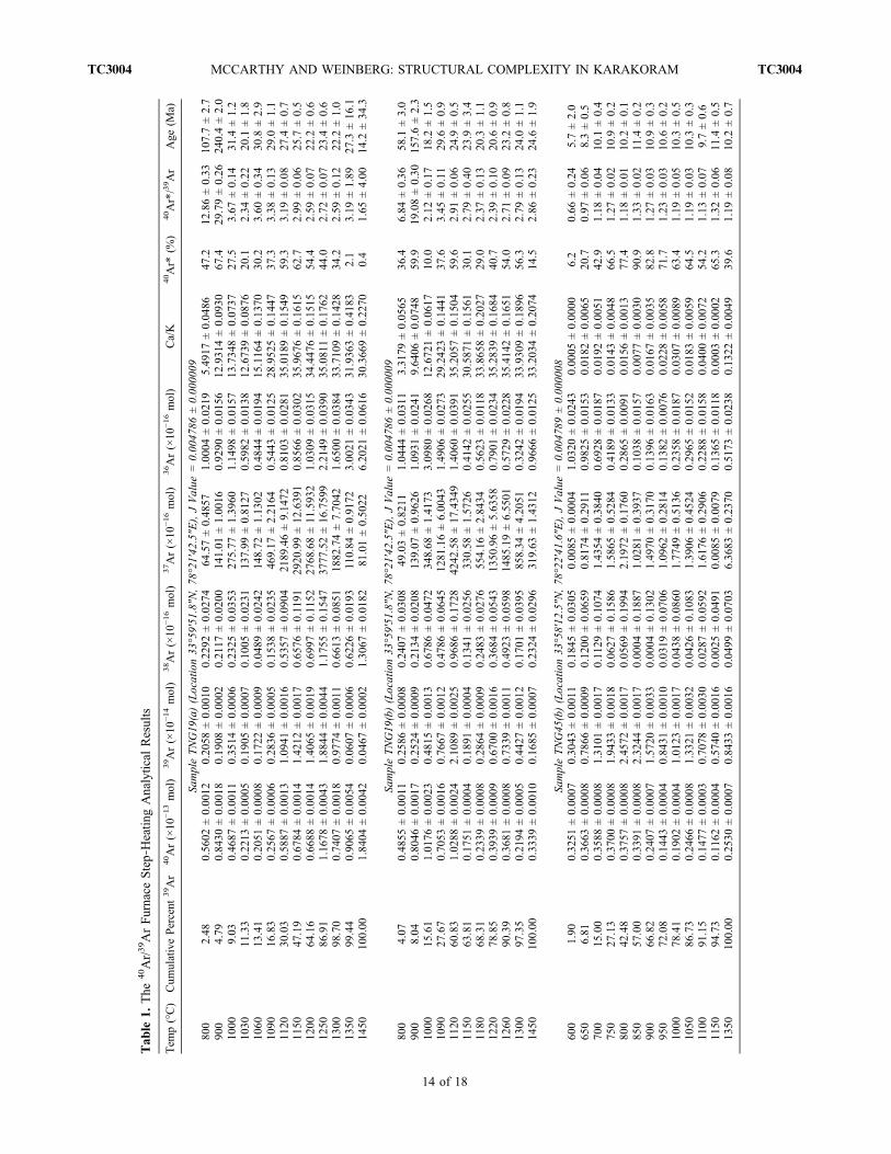
Tab
le1.
The
40Ar/39ArFurnace
Step‐Heatin
gAnalytical
Results
Tem
p(°C)
Cum
ulativePercent
39Ar
40Ar(×10
−13mol)
39Ar(×10
−14mol)
38Ar(×10
−16mol)
37Ar(×10
−16mol)
36Ar(×10
−16mol)
Ca/K
40Ar*
(%)
40Ar*/39Ar
Age
(Ma)
SampleTNG19
(a)(Location33
°59′51
.8″N
,78
°21′42
.5″E
),JValue
=0.00
4786
±0.00
0009
800
2.48
0.56
02±0.00
120.20
58±0.00
100.22
92±0.02
7464
.57±0.48
571.00
04±0.02
195.49
17±0.04
8647
.212
.86±0.33
107.7±2.7
900
4.79
0.84
30±0.00
180.19
08±0.00
020.21
17±0.02
0014
1.01
±1.00
160.92
90±0.01
5612
.931
4±0.09
3067
.429
.79±0.26
240.4±2.0
1000
9.03
0.46
87±0.00
110.35
14±0.00
060.23
25±0.03
5327
5.77
±1.39
601.14
98±0.01
5713
.734
8±0.07
3727
.53.67
±0.14
31.4
±1.2
1030
11.33
0.22
13±0.00
050.19
05±0.00
070.10
05±0.02
3113
7.99
±0.81
270.59
82±0.01
3812
.673
9±0.08
7620
.12.34
±0.22
20.1
±1.8
1060
13.41
0.20
51±0.00
080.17
22±0.00
090.04
89±0.02
4214
8.72
±1.13
020.48
44±0.01
9415
.116
4±0.13
7030
.23.60
±0.34
30.8
±2.9
1090
16.83
0.25
67±0.00
060.28
36±0.00
050.15
38±0.02
3546
9.17
±2.21
640.54
43±0.01
2528
.952
5±0.14
4737
.33.38
±0.13
29.0
±1.1
1120
30.03
0.58
87±0.00
131.09
41±0.00
160.53
57±0.09
0421
89.46±9.14
720.81
03±0.02
8135
.018
9±0.15
4959
.33.19
±0.08
27.4
±0.7
1150
47.19
0.67
84±0.00
141.42
12±0.00
170.65
76±0.11
9129
20.99±12
.639
10.85
66±0.03
0235
.967
6±0.16
1562
.72.99
±0.06
25.7
±0.5
1200
64.16
0.66
88±0.00
141.40
65±0.00
190.69
97±0.11
5227
68.68±11
.593
21.03
09±0.03
1534
.447
6±0.15
1554
.42.59
±0.07
22.2
±0.6
1250
86.91
1.16
78±0.00
431.88
44±0.00
441.17
55±0.15
4737
77.52±16
.759
92.21
49±0.03
9035
.081
1±0.17
6244
.02.72
±0.07
23.4
±0.6
1300
98.70
0.74
07±0.00
180.97
74±0.00
110.66
13±0.08
5118
82.74±7.70
421.65
00±0.03
8433
.710
9±0.14
2834
.22.59
±0.12
22.2
±1.0
1350
99.44
0.90
65±0.00
540.06
07±0.00
060.62
26±0.01
9311
0.84
±0.91
723.00
21±0.03
4331
.936
3±0.41
832.1
3.19
±1.89
27.3
±16
.114
5010
0.00
1.84
04±0.00
420.04
67±0.00
021.30
67±0.01
8281
.01±0.50
226.20
21±0.06
1630
.366
9±0.22
700.4
1.65
±4.00
14.2
±34
.3
SampleTNG19
(b)(Location33
°59′51
.8″N
,78
°21′42
.5″E
),JValue
=0.00
4786
±0.00
0009
800
4.07
0.48
55±0.00
110.25
86±0.00
080.24
07±0.03
0849
.03±0.82
111.04
44±0.03
113.31
79±0.05
6536
.46.84
±0.36
58.1
±3.0
900
8.04
0.80
46±0.00
170.25
24±0.00
090.21
34±0.02
0813
9.07
±0.96
261.09
31±0.02
419.64
06±0.07
4859
.919
.08±0.30
157.6±2.3
1000
15.61
1.01
76±0.00
230.48
15±0.00
130.67
86±0.04
7234
8.68
±1.41
733.09
80±0.02
6812
.672
1±0.06
1710
.02.12
±0.17
18.2
±1.5
1090
27.67
0.70
53±0.00
160.76
67±0.00
120.47
86±0.06
4512
81.16±6.00
431.49
06±0.02
7329
.242
3±0.14
4137
.63.45
±0.11
29.6
±0.9
1120
60.83
1.02
88±0.00
242.10
89±0.00
250.96
86±0.17
2842
42.58±17
.434
91.40
60±0.03
9135
.205
7±0.15
0459
.62.91
±0.06
24.9
±0.5
1150
63.81
0.17
51±0.00
040.18
91±0.00
040.13
41±0.02
5633
0.58
±1.57
260.41
42±0.02
5530
.587
1±0.15
6130
.12.79
±0.40
23.9
±3.4
1180
68.31
0.23
39±0.00
080.28
64±0.00
090.24
83±0.02
7655
4.16
±2.84
340.56
23±0.01
1833
.865
8±0.20
2729
.02.37
±0.13
20.3
±1.1
1220
78.85
0.39
39±0.00
090.67
00±0.00
160.36
84±0.05
4313
50.96±5.63
580.79
01±0.02
3435
.283
9±0.16
8440
.72.39
±0.10
20.6
±0.9
1260
90.39
0.36
81±0.00
080.73
39±0.00
110.49
23±0.05
9814
85.19±6.55
010.57
29±0.02
2835
.414
2±0.16
5154
.02.71
±0.09
23.2
±0.8
1300
97.35
0.21
94±0.00
050.44
27±0.00
120.17
01±0.03
9585
8.34
±4.20
510.32
42±0.01
9433
.930
9±0.18
9656
.32.79
±0.13
24.0
±1.1
1450
100.00
0.33
39±0.00
100.16
85±0.00
070.23
24±0.02
9631
9.63
±1.43
120.96
66±0.01
2533
.203
4±0.20
7414
.52.86
±0.23
24.6
±1.9
SampleTNG45
(b)(Location33
°58′12
.5″N
,78
°22′41
.6″E
),JValue
=0.00
4789
±0.00
0008
600
1.90
0.32
51±0.00
070.30
43±0.00
110.18
45±0.03
050.00
85±0.00
041.03
20±0.02
430.00
05±0.00
006.2
0.66
±0.24
5.7±2.0
650
6.81
0.36
63±0.00
080.78
66±0.00
090.12
00±0.06
590.81
74±0.29
110.98
25±0.01
530.01
82±0.00
6520
.70.97
±0.06
8.3±0.5
700
15.00
0.35
88±0.00
081.31
01±0.00
170.11
29±0.10
741.43
54±0.38
400.69
28±0.01
870.01
92±0.00
5142
.91.18
±0.04
10.1
±0.4
750
27.13
0.37
00±0.00
081.94
33±0.00
180.06
27±0.15
861.58
65±0.52
840.41
89±0.01
330.01
43±0.00
4866
.51.27
±0.02
10.9
±0.2
800
42.48
0.37
57±0.00
082.45
72±0.00
170.05
69±0.19
942.19
72±0.17
600.28
65±0.00
910.01
56±0.00
1377
.41.18
±0.01
10.2
±0.1
850
57.00
0.33
91±0.00
082.32
44±0.00
170.00
04±0.18
871.02
81±0.39
370.10
38±0.01
570.00
77±0.00
3090
.91.33
±0.02
11.4
±0.2
900
66.82
0.24
07±0.00
071.57
20±0.00
330.00
04±0.13
021.49
70±0.31
700.13
96±0.01
630.01
67±0.00
3582
.81.27
±0.03
10.9
±0.3
950
72.08
0.14
43±0.00
040.84
31±0.00
100.03
19±0.07
061.09
62±0.28
140.13
82±0.00
760.02
28±0.00
5871
.71.23
±0.03
10.6
±0.2
1000
78.41
0.19
02±0.00
041.01
23±0.00
170.04
38±0.08
601.77
49±0.51
360.23
58±0.01
870.03
07±0.00
8963
.41.19
±0.05
10.3
±0.5
1050
86.73
0.24
66±0.00
081.33
21±0.00
320.04
26±0.10
831.39
06±0.45
240.29
65±0.01
520.01
83±0.00
5964
.51.19
±0.03
10.3
±0.3
1100
91.15
0.14
77±0.00
030.70
78±0.00
300.02
87±0.05
921.61
76±0.29
060.22
88±0.01
580.04
00±0.00
7254
.21.13
±0.07
9.7±0.6
1150
94.73
0.11
62±0.00
040.57
40±0.00
160.00
25±0.04
910.00
85±0.00
790.13
65±0.01
180.00
03±0.00
0265
.31.32
±0.06
11.4
±0.5
1350
100.00
0.25
30±0.00
070.84
33±0.00
160.04
99±0.07
036.36
83±0.23
700.51
73±0.02
380.13
22±0.00
4939
.61.19
±0.08
10.2
±0.7
MCCARTHY AND WEINBERG: STRUCTURAL COMPLEXITY IN KARAKORAM TC3004TC3004
14 of 18

Tab
le2.
The
40Ar/39ArLaser
Step‐Heatin
gof
Hornb
lend
eSam
pleTNG45
mm
atLocation33
°58′12
.5″N
,78
°22′41
.6″E
Step
Cum
ulativePercent
39Ar
40Ar(×10
−13mol)
39Ar(×10
−14mol)
38Ar(×10
−16mol)
37Ar(×10
−16mol)
36Ar(×10
−16mol)
Ca/K
40Ar*
(%)
40Ar*/39Ar
Age
(Ma)
SampleTNG45
mm/H1,
JValue
=0.00
4789
±0.00
0008
11.53
0.03
53±0.00
010.04
17±0.00
010.02
04±0.00
606.83
40±0.15
960.06
65±0.00
442.87
13±0.06
7344
.33.74
7±0.31
232
.09±2.65
29.93
0.05
06±0.00
010.22
81±0.00
050.07
31±0.02
0172
.791
7±0.38
970.04
35±0.00
255.58
39±0.03
1974
.61.65
5±0.03
314
.25±0.28
310
0.00
0.42
30±0.00
092.44
68±0.00
290.70
48±0.19
7581
4.83
44±3.45
990.14
16±0.00
675.82
79±0.02
5790
.11.55
8±0.00
913
.41±0.08
SampleTNG45
mm/H2,
JValue
=0.00
4789
±0.00
0008
112
.84
0.10
37±0.00
020.27
80±0.00
050.09
62±0.02
2677
.996
6±0.41
210.17
90±0.00
324.90
94±0.02
7349
.01.82
7±0.03
515
.72±0.30
234
.88
0.08
78±0.00
020.47
75±0.00
080.12
49±0.03
9017
2.49
81±0.81
450.05
17±0.00
286.32
19±0.03
1682
.61.51
9±0.01
813
.07±0.15
310
0.00
0.24
07±0.00
051.41
04±0.00
160.41
42±0.11
4548
0.11
21±2.28
430.07
12±0.00
555.95
72±0.02
9291
.21.55
7±0.01
213
.41±0.11
SampleTNG45
mm/H3,
JValue
=0.00
4789
±0.00
0008
18.95
0.08
07±0.00
020.18
21±0.00
030.06
36±0.01
5255
.862
6±0.30
150.13
20±0.00
435.36
78±0.03
0651
.72.29
1±0.07
119
.69±0.61
235
.79
0.10
03±0.00
020.54
58±0.00
060.14
76±0.04
5018
9.90
80±0.86
250.04
35±0.00
376.08
92±0.02
8587
.21.60
2±0.02
013
.79±0.18
365
.82
0.10
07±0.00
030.61
08±0.00
100.16
45±0.04
9321
4.50
88±1.04
590.02
40±0.00
366.14
57±0.03
1692
.91.53
2±0.01
813
.19±0.15
410
0.00
0.12
24±0.00
030.69
51±0.00
110.22
49±0.05
6422
5.32
63±1.13
970.04
18±0.00
265.67
25±0.03
0189
.91.58
4±0.01
213
.63±0.10
SampleTNG45
mm/H4,
JValue
=0.00
4789
±0.00
0008
16.96
0.09
64±0.00
020.18
39±0.00
010.08
04±0.01
6054
.643
0±0.24
760.16
65±0.00
375.19
97±0.02
3949
.02.56
8±0.06
122
.06±0.52
223
.63
0.08
82±0.00
020.44
03±0.00
060.12
91±0.03
6014
7.21
52±0.68
810.06
06±0.00
305.85
13±0.02
8479
.71.59
6±0.02
113
.74±0.18
356
.35
0.14
51±0.00
030.86
40±0.00
060.22
23±0.07
0230
0.53
63±1.37
680.04
73±0.00
446.08
69±0.02
8290
.31.51
8±0.01
513
.07±0.13
410
0.00
0.19
77±0.00
041.15
30±0.00
160.33
20±0.09
3439
4.31
70±1
.506
00.06
64±0.00
295.98
47±0.02
4390
.11.54
5±0.00
913
.30±0.07
SampleTNG45
mm/H5,
JValue
=0.00
4789
±0.00
0008
16.91
0.09
28±0.00
020.18
56±0.00
020.07
59±0.01
6254
.638
1±0.25
0.14
23±0.00
515.15
26±0.02
4354
.72.73
7±0.08
123
.50±0.69
222
.73
0.08
25±0.00
020.42
52±0.00
060.13
96±0.03
4413
5.41
63±0.89
530.04
81±0.00
325.57
32±0.03
7682
.81.60
6±0.02
313
.83±0.19
365
.12
0.20
36±0.00
051.13
90±0.00
100.42
76±0.09
2335
3.98
47±1.74
870.06
14±0.00
415.43
89±0.02
7391
.11.62
8±0.01
214
.01±0.10
410
0.00
0.16
19±0.00
030.93
73±0.00
090.30
28±0.07
6129
2.44
45±1.42
230.04
67±0.00
485.46
03±0.02
7191
.51.58
0±0.01
513
.60±0.13
MCCARTHY AND WEINBERG: STRUCTURAL COMPLEXITY IN KARAKORAM TC3004TC3004
15 of 18
lead to steep geothermal gradients without the need for extraheat sources.[41] We postulate that deformation and cooling of the
migmatitic rock sequence of the Pangong MetamorphicComplex mark its exhumation due to transpression on theKarakoram Shear Zone. Meanwhile, the Karakoram Meta-morphic Complex was being underthrusted and foldedwithout having its amphibole cooling ages reset. At around10 Ma there was no resolvable temperature difference be-tween the two complexes, suggesting slow relative verticalmovement between them. This could be due to (1) a changeto dominant strike‐slip movement or (2) amalgamation ofthe two complexes due to localization of shearing to a brittlefault outside the area. In summary, most of the relativeexhumation recorded by the Pangong Metamorphic Com-plex took place during the 5 to 8 Myr period of rapidcooling between the end of anatexis and 10 Ma.
6.3. Large‐Scale Fold
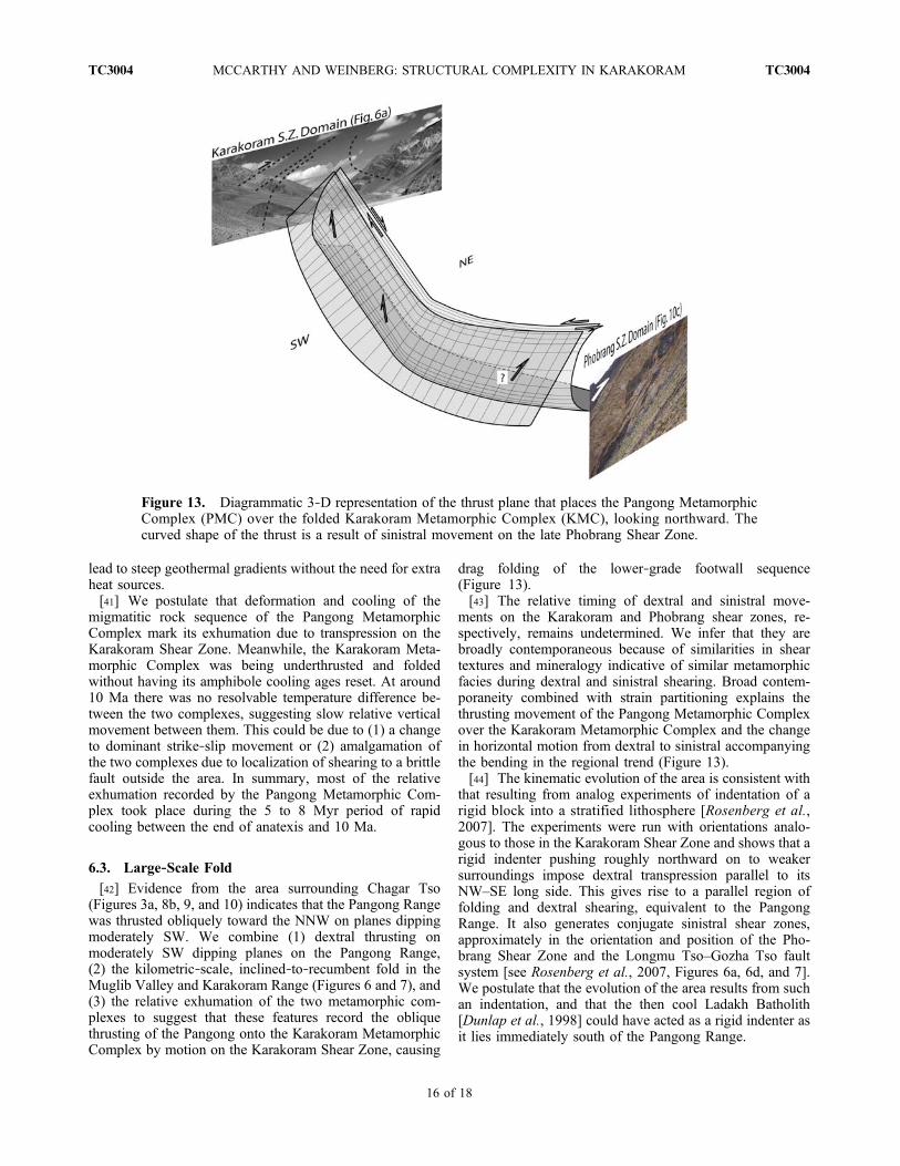
[42] Evidence from the area surrounding Chagar Tso(Figures 3a, 8b, 9, and 10) indicates that the Pangong Rangewas thrusted obliquely toward the NNW on planes dippingmoderately SW. We combine (1) dextral thrusting onmoderately SW dipping planes on the Pangong Range,(2) the kilometric‐scale, inclined‐to‐recumbent fold in theMuglib Valley and Karakoram Range (Figures 6 and 7), and(3) the relative exhumation of the two metamorphic com-plexes to suggest that these features record the obliquethrusting of the Pangong onto the Karakoram MetamorphicComplex by motion on the Karakoram Shear Zone, causing
drag folding of the lower‐grade footwall sequence(Figure 13).[43] The relative timing of dextral and sinistral move-
ments on the Karakoram and Phobrang shear zones, re-spectively, remains undetermined. We infer that they arebroadly contemporaneous because of similarities in sheartextures and mineralogy indicative of similar metamorphicfacies during dextral and sinistral shearing. Broad contem-poraneity combined with strain partitioning explains thethrusting movement of the Pangong Metamorphic Complexover the Karakoram Metamorphic Complex and the changein horizontal motion from dextral to sinistral accompanyingthe bending in the regional trend (Figure 13).[44] The kinematic evolution of the area is consistent with
that resulting from analog experiments of indentation of arigid block into a stratified lithosphere [Rosenberg et al.,2007]. The experiments were run with orientations analo-gous to those in the Karakoram Shear Zone and shows that arigid indenter pushing roughly northward on to weakersurroundings impose dextral transpression parallel to itsNW–SE long side. This gives rise to a parallel region offolding and dextral shearing, equivalent to the PangongRange. It also generates conjugate sinistral shear zones,approximately in the orientation and position of the Pho-brang Shear Zone and the Longmu Tso–Gozha Tso faultsystem [see Rosenberg et al., 2007, Figures 6a, 6d, and 7].We postulate that the evolution of the area results from suchan indentation, and that the then cool Ladakh Batholith[Dunlap et al., 1998] could have acted as a rigid indenter asit lies immediately south of the Pangong Range.
Figure 13. Diagrammatic 3‐D representation of the thrust plane that places the Pangong MetamorphicComplex (PMC) over the folded Karakoram Metamorphic Complex (KMC), looking northward. Thecurved shape of the thrust is a result of sinistral movement on the late Phobrang Shear Zone.
MCCARTHY AND WEINBERG: STRUCTURAL COMPLEXITY IN KARAKORAM TC3004TC3004
16 of 18
[45] The structures documented here do not supportRaterman et al.’s [2007] conclusion that the 27 km widebend in the trend of the Karakoram Shear Zone around thePangong Range results from transtension imposed by thetriple junction with the sinistral Longmu Tso Fault, 40 km tothe north of the area studied here. We confirm earlier con-clusions [Weinberg et al., 2000] that the bend is caused bytranspression and splitting of the Karakoram Shear Zoneinto two strands, wrapping around the Pangong Range,allowing the exhumation of its high‐grade metamorphicrocks.
7. Conclusions[46] We conclude that dextral transpression imposed by a
rigid indenter pushing to the north, possibly the Ladakh
Batholith, could explain (1) the exhumation of the PangongMetamorphic Complex, (2) the large‐scale drag folding ofthe Karakoram Metamorphic Complex underneath the thrustexhuming the Pangong Metamorphic Complex, and (3) thedevelopment of the sinistral system. The rocks mappedrecord intense and pervasive ductile deformation over widezones in the form of shearing and folding, and rigid blockconceptualization of continental crust deformation andkinematic analyses may yield misleading results if ductiledeformation is neglected.
[47] Acknowledgments. We thank Geordie Mark and HenningReichardt for discussions in the field. We thank also the Associate Editor,Hervé Leloup, and an anonymous reviewer for their thoughtful reviewswhich helped to improve this paper.
ReferencesBaldwin, S. L., T. M. Harrison, and J. D. Fitzgerald
(1990), Diffusion of 40Ar in metamorphic horn-blende, Contrib. Mineral. Petrol., 105, 691–703,doi:10.1007/BF00306534.
Bhutani, R., K. Pande, and N. Desai (2003), Age of theKarakoram fault activation: 40Ar/39Ar geochrono-logical study of Shyok suture zone in northernLadakh, India, Curr. Sci., 84(11), 1454–1458.
Brown, E. T., R. Bendick, D. L. Bourlès, V. Gaur,P. Molnar, G. M. Raisbeck, and F. Yiou (2002), Sliprates of the Karakorum fault, Ladakh, India, deter-mined using cosmic ray exposure dating of debrisflows and moraines, J. Geophys. Res., 107(B9),2192, doi:10.1029/2000JB000100.
Chevalier, M. L., F. J. Ryerson, P. Tapponnier, R. C.Finkel, J. Van der Woerd, H. B. Li, and Q. Liu(2005), Slip‐rate measurements on the KarakorumFault may imply secular variations in fault motion,Science, 307(5708), 411–414, doi:10.1126/sci-ence.1105466.
Dunlap, W. J., R. F. Weinberg, and M. P. Searle (1998),Karakoram fault zone rocks cool in two phases,J. Geol. Soc. London, 155, 903–912, doi:10.1144/gsjgs.155. 6.0903.
Harrison, T. M., I. Duncan, and I. McDougall (1985),Diffusion of 40Ar in biotite: Temperature, pressureand compositional effects, Geochim. Cosmochim.Acta, 49, 2461–2468, doi:10.1016/0016-7037(85)90246-7.
Lacassin, R., et al. (2004a), Large‐scale geometry, off-set and kinematic evolution of the Karakorum Fault,Tibet, Earth Planet. Sci. Lett., 219(3–4), 255–269,doi:10.1016/S0012-821X(04)00006-8.
Lacassin, R., et al. (2004b), Reply to comment on“Large‐scale geometry, offset and kinematic evolu-tion of the Karakorum fault, Tibet,’ Earth Planet.Sci. Lett., 229(1–2), 159–163, doi:10.1016/j.epsl.2004.07.045.
Murphy, M. A., and W. P. Burgess (2006), Geometry,kinematics, and landscape characteristics of anactive transtension zone, Karakoram fault system,southwest Tibet, J. Struct. Geol., 28(2), 268–283,doi:10.1016/j.jsg.2005.10.009.
Murphy, M. A., A. Yin, P. Kapp, T. M. Harrison, D. Lin,and J. H. Guo (2000), Southward propagation of theKarakoram fault system, southwest Tibet: Timingand magnitude of slip, Geology, 28(5), 451–454,doi:10.1130/0091-7613(2000)28<451:SPOTKF>2.0.CO;2.
Murphy, M. A., A. Yin, P. Kapp, T. M. Harrison, C. E.Manning, F. J. Ryerson, L. Ding, and J. H. Guo(2002), Structural evolution of the Gurla Mandhatadetachment system, southwest Tibet: Implicationsfor the eastward extent of the Karakoram fault system,Geol. Soc. Am. Bull., 114(4), 428–447, doi:10.1130/0016-7606(2002)114<0428:SEOTGM>2.0.CO;2.
Passchier, C. W., and R. A. J. Trouw (1998), Microtec-tonics, 289 pp., Springer, Berlin.
Peltzer, G., and P. Tapponnier (1988), Formation andevolution of strike‐slip faults, rifts, and basinsduring the India‐Asia collision: An experimentalapproach, J. Geophys. Res., 93, 15,085–15,117,doi:10.1029/JB093iB12p15085.
Phillips, D., and J. W. Harris (2008), Provenance stud-ies from 40Ar/39Ar dating of mineral inclusions indiamonds: Methodological tests on the Orapa kim-berlite, Botswana, Earth Planet. Sci. Lett., 274,169–178, doi:10.1016/j.epsl.2008.07.019.
Phillips, G., C. J. L.Wilson, D. Phillips, and S. Szczepanski(2007), Thermochronological (40Ar/39Ar) evidencefor Early Palaeozoic basin inversion within thesouthern Prince Charles Mountains, East Antarctica:Implications for East Gondwana, J. Geol. Soc., 164,771–784, doi:10.1144/0016-76492006-073.
Phillips, R. J., and M. P. Searle (2007), Macrostructuraland microstructural architecture of the KarakoramFault: Relationship between magmatism andstrike‐slip faulting, Tectonics, 26 , TC3017,doi:10.1029/2006TC001946.
Phillips, R. J., R. R. Parrish, and M. P. Searle (2004),Age constraints on ductile deformation and long‐term slip rates along the Karakoram fault zone,Ladakh, Earth Planet. Sci. Lett., 226(3–4), 305–319,doi:10.1016/j.epsl.2004.07.037.
Raterman, N. S., E. Cowgill, and D. Lin (2007), Variablestructural style along the Karakoram Fault explainedusing triple‐junction analysis of intersecting faults,Geosphere, 3(2), 71–85, doi:10.1130/GES00067.1.
Ravikant, V. (2006), Utility of Rb‐Sr geochronology inconstraining Miocene and Cretaceous events in theeastern Karakoram, Ladakh, India, J. Asian EarthSci., 27, 534–543, doi:10.1016/j.jseaes.2005.05.007.
Ravikant, V., F. Y. Wu, and W. Q. Ji (2009), ZirconU‐Pb and Hf isotopic constraints on petrogenesis ofthe Cretaceous‐Tertiary granites in eastern Karakoramand Ladakh, India, Lithos, 110, 153–166.
Reichardt, H., R. F. Weinberg, U. B. Andersson, andM. C. Fanning (2010), Hybridization of graniticmagmas in the source: The origin of the KarakoramBatholith, Ladakh, NW India, Lithos, 116, 249–272.
Renne, P. R., O. T. Tobisch, and J. B. Saleeby (1993),Thermochronologic record of pluton emplacement,deformation, and exhumation at Courtright shearzone, central Sierra Nevada, Calif. Geol., 21,331–334.
Renne, P. R., C. C. Swisher, A. L. Deino, D. B. Karner,T. L. Owens, and D. J. DePaolo (1998), Intercali-bration of standards, absolute ages and uncertaintiesin 40Ar/39Ar dating, Chem. Geol., 145, 117–152,doi:10.1016/S0009-2541(97)00159-9.
Rolland, Y., and A. Pêcher (2001), The Pangonggranulites of the Karakoram Fault (western Tibet):
Vertical extrusion within a lithosphere‐scale fault?,C. R. Acad. Sci., Ser. II, 6, 363–370.
Rolland, Y., G. Mahéo, A. Pêcher, and I. M. Villa(2009), Syn‐kinematic emplacement of the Pangongmetamorphic and magmatic complex along theKarakorum Fault (N Ladakh), J. Asian Earth Sci.,34(1), 10–25, doi:10.1016/j.jseaes.2008.03.009.
Rosenberg, C. L., J.‐P. Brun, F. Cagnard, and D. Gapais(2007), Oblique indentation in the Eastern Alps:Insights from laboratory experiments, Tectonics,26, TC2003, doi:10.1029/2006TC001960.
Rutter, E. H., D. R. Faulkner, K. H. Brodie, R. J. Phillips,andM. P. Searle (2007), Rock deformation processesin the Karakoram fault zone, eastern Karakoram,Ladakh, NW India, J. Struct. Geol., 29(8), 1315–1326, doi:10.1016/j.jsg.2007.05.001.
Searle, M. P. (1996), Geological evidence against large‐scale pre‐Holocene offsets along the KarakoramFault: Implications for the limited extrusion of theTibetan Plateau, Tectonics, 15(1), 171–186,doi:10.1029/95TC01693.
Searle, M. P., and R. J. Phillips (2004), A comment on“Large‐scale geometry, offset, and kinematic evolu-tion of the Karakoram Fault, Tibet” by R. Lacassinet al., Earth Planet. Sci. Lett., 229(1–2), 155–158,doi:10.1016/j.epsl.2004.07.044.
Searle, M. P., and R. J. Phillips (2007), Relationshipsbetween right‐lateral shear along the KarakoramFault and metamorphism, magmatism, exhumationand uplift: Evidence from the K2‐Gasherbrum‐Pangong ranges, north Pakistan and Ladakh, J. Geol.Soc., 164, 439–450, doi:10.1144/0016-76492006-072.
Searle, M. P., R. F. Weinberg, and W. J. Dunlap (1998),Transpressional tectonics along the Karakoram faultzone, northern Ladakh: Constraints on Tibetan extru-sion, in Continental Transpressional and Transpres-sional Tectonics, edited by R. E. Holdsworth et al.,Geol. Soc. Spec. Publ., 135, 307–326, doi:10.1144/GSL.SP.1998.135.01.20.
Upadhyay, R., J. Rai, and A. K. Sinha (2005), Newrecord of Bathonian‐Callovian calcareous nanno-fossils in the eastern Karakoram block: A possibleclue to understanding the dextral offset along theKarakoram Fault, Terra Nova, 17(2), 149–157,doi:10.1111/j.1365-3121.2005.00602.x.
Valli, F., N. Arnaud, P. H. Leloup, E. R. Sobel, G. Mahéo,R. Lacassin, S. Guillot, H. Li, P. Tapponnier, andZ. Xu (2007), Twenty million years of continuousdeformation along the Karakorum Fault, westernTibet: A thermochronological analysis, Tectonics,26, TC4004, doi:10.1029/2005TC001913.
Valli, F., et al. (2008), New U‐Th/Pb constraints ontiming of shearing and long‐term slip‐rate on theKarakorum Fault , Tectonics , 27 , TC5007,doi:10.1029/2007TC002184.
MCCARTHY AND WEINBERG: STRUCTURAL COMPLEXITY IN KARAKORAM TC3004TC3004
17 of 18

Vernon, R. H. (2004), A Practical Guide to RockMicrostructures, 594 pp., Cambridge Univ. Press,Cambridge, U. K.
Weinberg, R. F., and W. J. Dunlap (2000), Growth anddeformation of the Ladakh Batholith, northwestHimalayas: Implications for timing of continentalcollision and origin of calc‐alkaline batholiths,J. Geol., 108, 303–320, doi:10.1086/314405.
Weinberg, R. F., and G. Mark (2008), Magma migra-tion, folding, and disaggregation of migmatites inthe Karakoram Shear Zone, Ladakh, NW India,
Geol. Soc. Am. Bull., 120, 994–1009, doi:10.1130/B26227.1.
Weinberg, R. F., W. J. Dunlap, and M. Whitehouse(2000), New field, structural and geochronologicaldata from the Shyok and Nubra valleys, northernLadakh: Linking Kohistan to Tibet, in Tectonicsof the Nanga Parbat Syntaxis and the WesternHimalaya, edited by T. P. J. Khan et al., Geol.Soc. Spec. Publ., 170, 253–275, doi:10.1144/GSL.SP.2000.170.01.14.
Weinberg, R. F., G. Mark, and H. Reichardt (2009),Magma ponding in the Karakoram Shear Zone,
Ladakh, NW India, Geol. Soc. Am. Bull., 121,278–285.
Wright, T. J., B. Parsons, P. C. England, and E. J. Fielding(2004), InSAR observations of low slip rates on themajor faults of western Tibet, Science, 305(5681),236–239, doi:10.1126/science.1096388.
M. R. McCarthy and R. F. Weinberg, School ofGeosciences, Monash University, Clayton, Vic 3800,Australia. ([email protected])
MCCARTHY AND WEINBERG: STRUCTURAL COMPLEXITY IN KARAKORAM TC3004TC3004
18 of 18