Embed Size (px)
Citation preview
CITY OF BOULDER Facilities and Asset Management
NewBritainandParkCentralBuildings
StructuralFloodAssessmentRevised‐March18,2013
Anthem, LLC 5171 Eldorado Springs Drive
Suite M Boulder, CO 80303
(303) 848-8497
web: anthemstrcutural.com e-mail: [email protected]

New Britain & Park Central Buildings Anthem, LLC Structural Flood Assessment 12-045
i
TABLE OF CONTENTS
1.0 EXECUTIVE SUMMARY ................................................................................................................................ 1
2.0 INTRODUCTION .............................................................................................................................................. 2
2.1 SCOPE OF SERVICES .............................................................................................................................................. 2 2.2 ASSUMPTIONS AND BASIS OF ANALYSIS ............................................................................................................... 2 2.3 LIMITATIONS AND EXCEPTIONS ............................................................................................................................ 2
3.0 SITE LOCATION AND CHARACTERISTICS ............................................................................................. 3
3.1 LOCATION AND LEGAL DESCRIPTION ................................................................................................................... 3 3.2 SITE CHARACTERISTICS ........................................................................................................................................ 4 3.3 CURRENT USE OF PROPERTY ................................................................................................................................ 4
4.0 INFORMATION PROVIDED BY THE CITY OF BOULDER .................................................................... 5
4.1 DRAWINGS ............................................................................................................................................................ 5 4.2 BRIDGE CONSTRUCTION PHOTOS .......................................................................................................................... 5 4.3 FLOOD INFORMATION ........................................................................................................................................... 5
5.0 INVESTIGATION OF EXISTING CONDITIONS ........................................................................................ 5
5.1 METHODOLOGY AND LIMITING CONDITIONS ........................................................................................................ 5
6.0 BUILDING DESCRIPTIONS ........................................................................................................................... 6
6.1 DESCRIPTION OF NEW BRITAIN BUILDING ............................................................................................................ 6 6.2 DESCRIPTION OF PARK CENTRAL BUILDING ......................................................................................................... 6
7.0 FINDINGS AND REQUIRED IMPROVEMENTS ........................................................................................ 7
7.1 FINDINGS .............................................................................................................................................................. 7 7.2 NEW BRITAIN ....................................................................................................................................................... 8 7.3 PARK CENTRAL ................................................................................................................................................... 10
8.0 CONCLUSIONS .............................................................................................................................................. 11
9.0 REFERENCES ................................................................................................................................................. 12
APPENDIX A FLOOD STUDY INFORMATION
APPENDIX B STRUCTURAL CALCULATIONS
APPENDIX C HISTORIC SOIL BORING LOGS

New Britain & Park Central Buildings Anthem, LLC Structural Flood Assessment 12-045
1
1.0 EXECUTIVE SUMMARY
We have assessed the ability of the New Britain and Park Central buildings to resist loading and
water infiltration for the 100-year flood event, and what improvements would be required to
bring the structures into compliance with current structural codes. We have also investigated
what improvements would be required to support the structures in the event that the existing
foundations are undermined due to scour. The design criteria was based on the more stringent of
the newly adopted 2012 Boulder Creek floodplain study and the preceding 1994 Boulder Creek
floodplain study. The velocities utilized in the analysis range from 7.93 feet per second with a
flood protection elevation of 3.24 feet above grade for the New Britain building, to 5.24 feet per
second with a flood protection elevation of 3.40 feet above grade for the Park Central building.
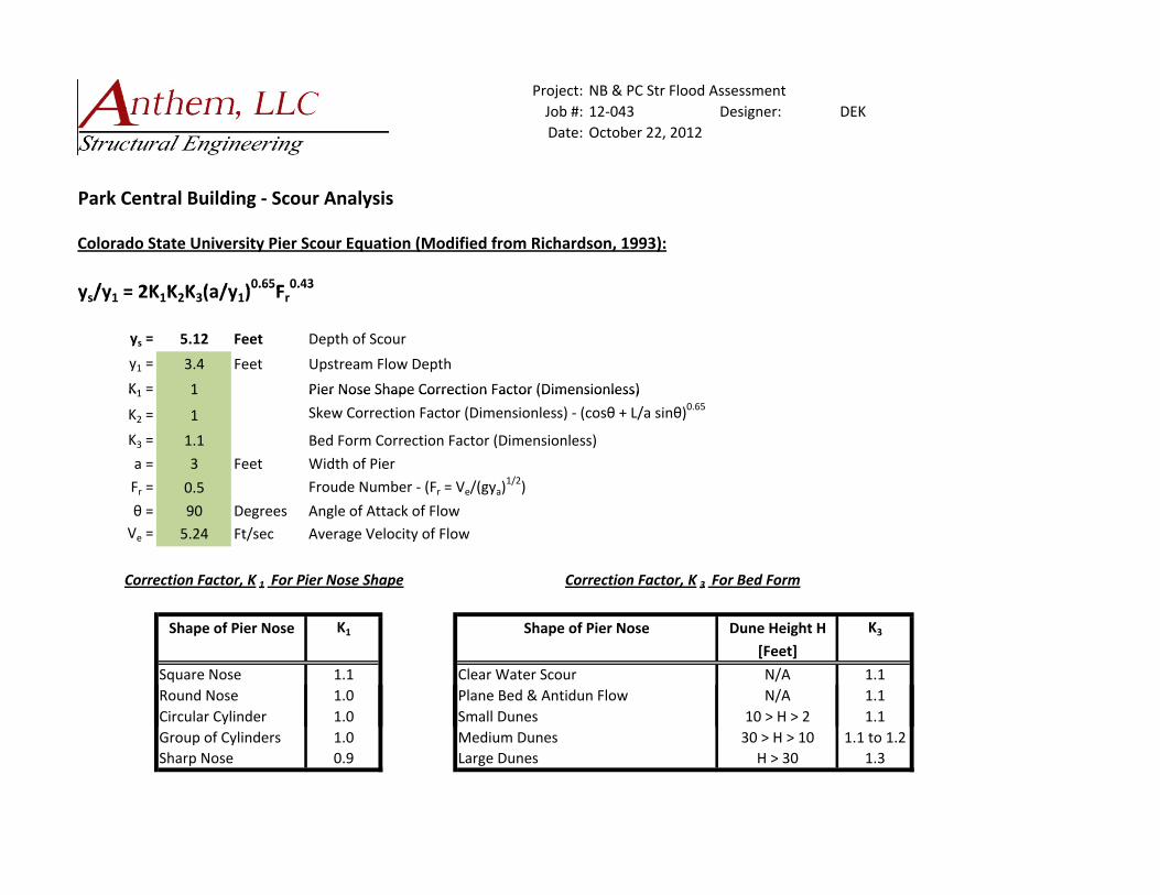
The depth of scour was determined to be approximately 1.6 feet below the footings at the New
Britain building and 3.6 feet below the footings at the Park Central building. The alternative
solutions investigated are site improvement solutions including providing rip rap protection
around the perimeter of the structures, and permeation grouting around the perimeter of the
foundations. Our solutions are described in more detail within the body of this report.
After conducting our assessment, we have concluded that the buildings as constructed are not
able to withstand the 100-year flood event without improving the structures. Based on the flood
and soil parameters for the site, the foundations of both buildings would be undermined due to
scour, which would result in the collapse of the structures. The improvements that would be
required to floodproof the existing structures excluding site improvements are approximately
$31,000 for the Park Central Building and $142,000 for the New Britain Building. The costs for
the site improvements that would be required to prevent the foundations from being undermined
range from $115,000 to $190,000 for the Park Central Building and $72,800 to $146,000. As
mentioned elsewhere in the report, there would be costs incurred in addition to the required
structural improvements, including the possible relocation of underground utilities.
Since the costs for the required structural improvements do not exceed 50% of the market value
of the structure, and the site improvements are not considered improvements to the building, the
improvements are not considered ‘substantial improvements’ as defined in 9-16-1 of the City of
Boulder Revised Code, and are therefore permitted.

New Britain & Park Central Buildings Anthem, LLC Structural Flood Assessment 12-045
2
2.0 INTRODUCTION
2.1 SCOPE OF SERVICES
The scope of structural services is to provide a report summarizing the results of alternate
methods of preventing the undermining of the New Britain and Park Central building
foundations due to scour, what improvements would need to be made to floodproof the
buildings, and the approximate cost associated with improving the buildings. Floodproofing
of architectural elements such as door gaskets and waterproof membranes are not included in
this report. Site and utility improvements are also not included in this report.
2.2 ASSUMPTIONS AND BASIS OF ANALYSIS
Our assumptions for the analysis of the New Britain and Park Central buildings are as
follows:
The soil profile is as indicated in the existing drawing set of the Park Central Building, and sieve analysis data of a soil sample collected on site
The water surface elevations are linearly interpolated between cross-sections The non-observable elements of the New Britain building are as described in Item 3.5 Presumptive market value of the buildings is approximately $120 per square foot per
the City of Boulder
The analysis is based on the information provided by the City of Boulder indicated in Item
4.0, including drawings of the Park Central Building, boring logs from the Park Central
Building, floodplain data from both the newly adopted 2012 Boulder Creek floodplain study
and the preceding 1994 Boulder Creek floodplain study, and photographs of the Broadway
Bridge reconstruction project. Additionally, our analysis was based on our investigation of
existing conditions outlined in Section 5.0.
2.3 LIMITATIONS AND EXCEPTIONS
Our analysis is limited to the information provided, and the observable elements of the
structures.

New Britain & Park Central Buildings Anthem, LLC Structural Flood Assessment 12-045
3
3.0 SITE LOCATION AND CHARACTERISTICS
3.1 LOCATION AND LEGAL DESCRIPTION
The Park Central Building at 1739 N. Broadway St. and the New Britain Building 1101
Arapahoe Ave. at are located immediately adjacent to each other on the northwest corner of
Arapahoe Ave. and Broadway St. in downtown Boulder as illustrated below. Mustard’s Last
Stand, a hotdog and burger restaurant is located at the southeast corner of the Park Central
Building. A playground area and Boulder Creek are directly to the north of the site, with the
city’s Municipal Building further north, across the creek. A parking lot and the main branch
of the Boulder Public Library are directly to the west of the site with the West Senior Center
further west. Across Arapahoe Ave. to the south is the Alfalfa’s grocery store and across
Broadway to the east are a gas station and a restaurant/office building, often referred to as the
Yocum Building.
Site Location
New Britain & Park Central Buildings Anthem, LLC Structural Flood Assessment 12-045
4
The legal descriptions for the two properties are:
New Britain Building: W 150 FT OF S 50 FT LOT 9 & W 150 FT OF N 50 FT OF S 100 FT
Lot 9 SMITHS & PT E ½ VACATED 11TH ST ADJ
Park Central Building: E 160 FT OF N 50 FT OF S 100 FT AND E 150 FT OF S 50 FT
LOT 9 SMITHS LESS SE 28 X 28 FT SPLIT TO ID 120058 11/94
3.2 SITE CHARACTERISTICS
The New Britain and Park Central buildings are located on fairly level ground that generally
slopes away from the structures both to the north, toward Boulder Creek and to the south,
toward Arapahoe Ave. Asphalt paved parking areas are located across the southern portion
of the site.
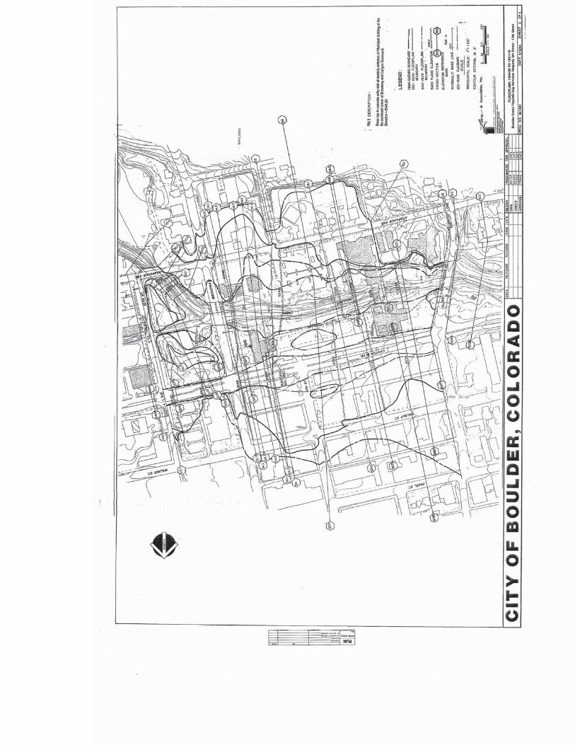
The City of Boulder has recently adopted a new floodplain study for Boulder Creek, which
will hereon be referred to as the 2012 Study. At this time, the study has not yet been
approved by the Federal Emergency Management Agency (FEMA). Until the new study is
adopted by FEMA, both the 2012 Study and the previous floodplain study, hereon referred to
as the 1994 Study must be considered to determine the flooding conditions for the site. Both
floodplain models indicate that the site is located within the 100-year floodplain, conveyance
zone and high hazard flood zone. The 100-year flood water depths around the buildings are
generally around 3 feet, with velocities ranging from approximately 5 feet per second to 8
feet per second. Floodplain maps and cross section information is included in Appendix A.
3.3 CURRENT USE OF PROPERTY
Both the New Britain Building and the Park Central Building are owned, managed and used
by the City of Boulder. Within the New Britain Building are Human Resources, Housing
and Human Services and Information Technology. The Park Central Building contains
Public Works, Community Planning & Sustainability and Planning and Development
Services. Although the property is zoned Public and allows these current uses, if the
structures were substantially damaged by a 100-year flood event, they could not be rebuilt
because they are located in the high hazard flood zone where structures intended for human
occupancy are not allowed.
New Britain & Park Central Buildings Anthem, LLC Structural Flood Assessment 12-045
5
4.0 INFORMATION PROVIDED BY THE CITY OF BOULDER
4.1 DRAWINGS
Structural, architectural and civil drawings of the Park Central building dated
December 15th, 1972.
Architectural drawing of the 2nd Floor plan for the New Britain Building Remodel,
dated May 8, 2006.
4.2 BRIDGE CONSTRUCTION PHOTOS
Photos from the Broadway Bridge over Boulder Creek replacement project
4.3 FLOOD INFORMATION
1994 Flood Study maps and data
2012 Flood Study maps and data
5.0 INVESTIGATION OF EXISTING CONDITIONS
5.1 METHODOLOGY AND LIMITING CONDITIONS
The original construction drawings that were provided by the City of Boulder were reviewed
to determine the existing structural configuration of the Park Central Building. These
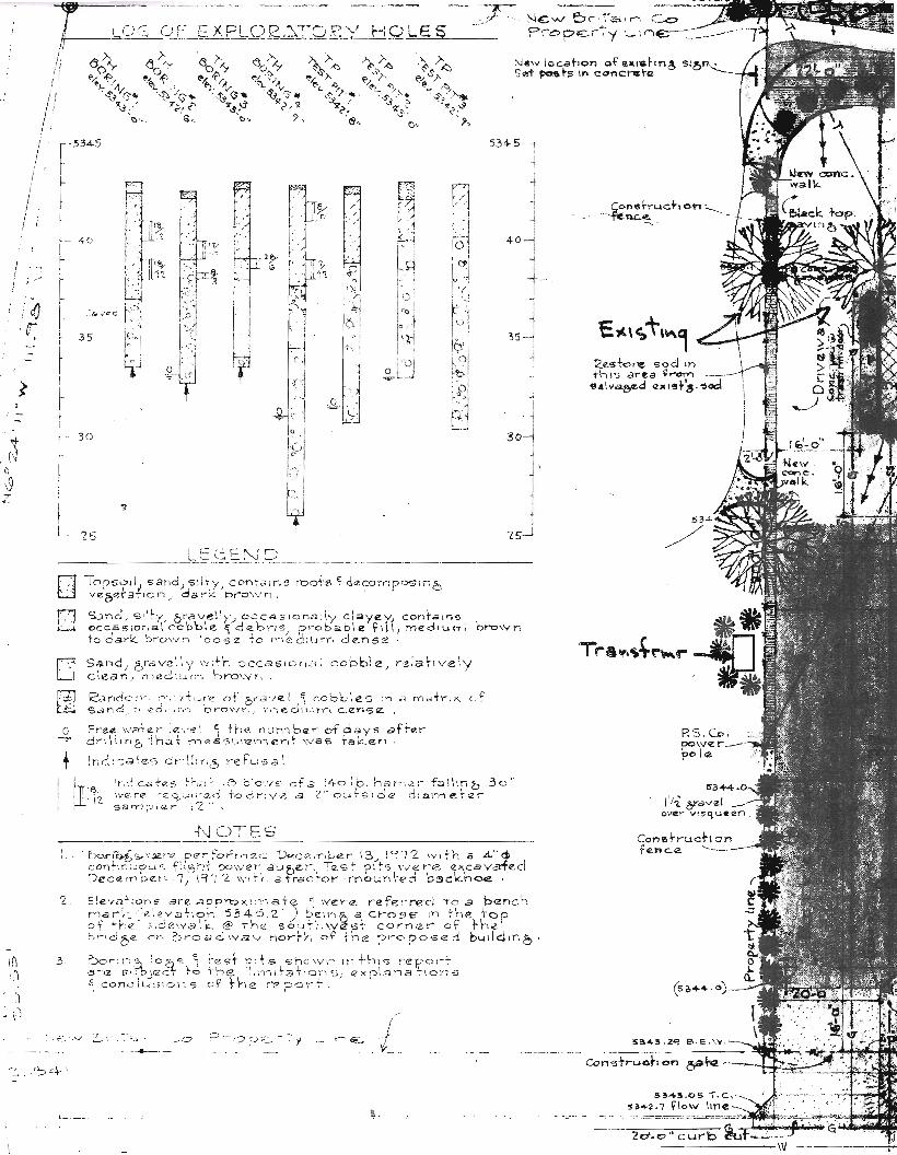
drawings also contained a soil boring log, included in Appendix C. Original construction
drawings were not available for the New Britain Building, so a field investigation was
performed to determine the sizes and configuration of foundation elements and structural
systems. Observations were limited to visible components. No destructive investigation or
soils testing were performed, other than a sieve analysis. There were no available soils
reports for the site.
Additional information about the foundation elements and existing soils was provided by city
personnel who had experience with construction projects in the area and had made field
observations of the excavations during the construction of the adjacent Broadway Bridge.
New Britain & Park Central Buildings Anthem, LLC Structural Flood Assessment 12-045
6
6.0 BUILDING DESCRIPTIONS
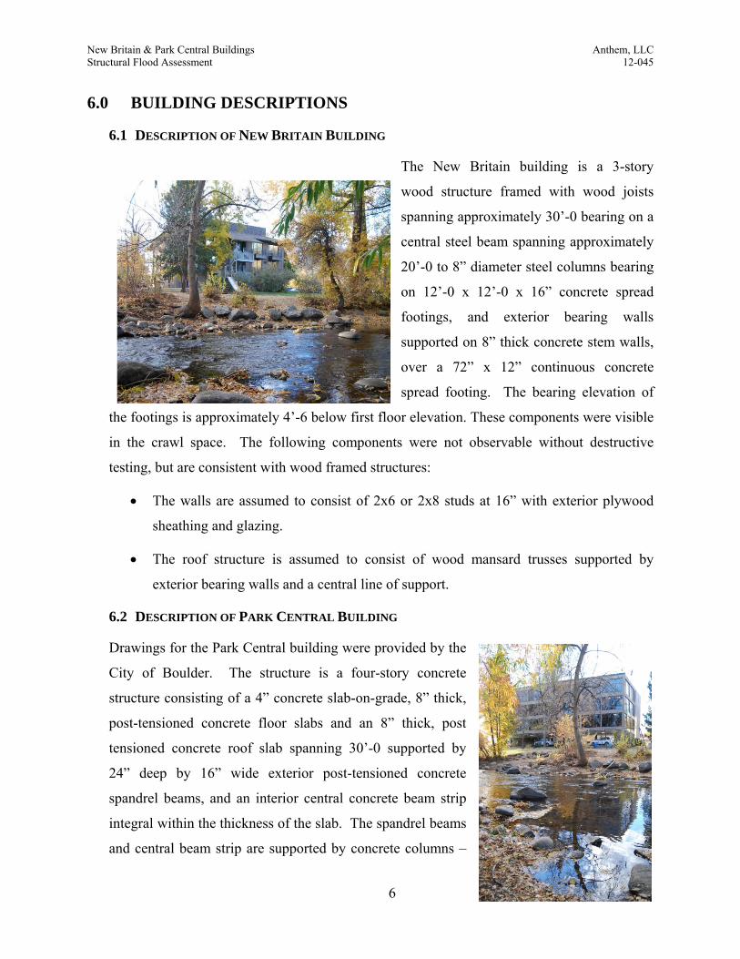
6.1 DESCRIPTION OF NEW BRITAIN BUILDING
The New Britain building is a 3-story
wood structure framed with wood joists
spanning approximately 30’-0 bearing on a
central steel beam spanning approximately
20’-0 to 8” diameter steel columns bearing
on 12’-0 x 12’-0 x 16” concrete spread
footings, and exterior bearing walls
supported on 8” thick concrete stem walls,
over a 72” x 12” continuous concrete
spread footing. The bearing elevation of
the footings is approximately 4’-6 below first floor elevation. These components were visible
in the crawl space. The following components were not observable without destructive
testing, but are consistent with wood framed structures:
The walls are assumed to consist of 2x6 or 2x8 studs at 16” with exterior plywood
sheathing and glazing.
The roof structure is assumed to consist of wood mansard trusses supported by
exterior bearing walls and a central line of support.
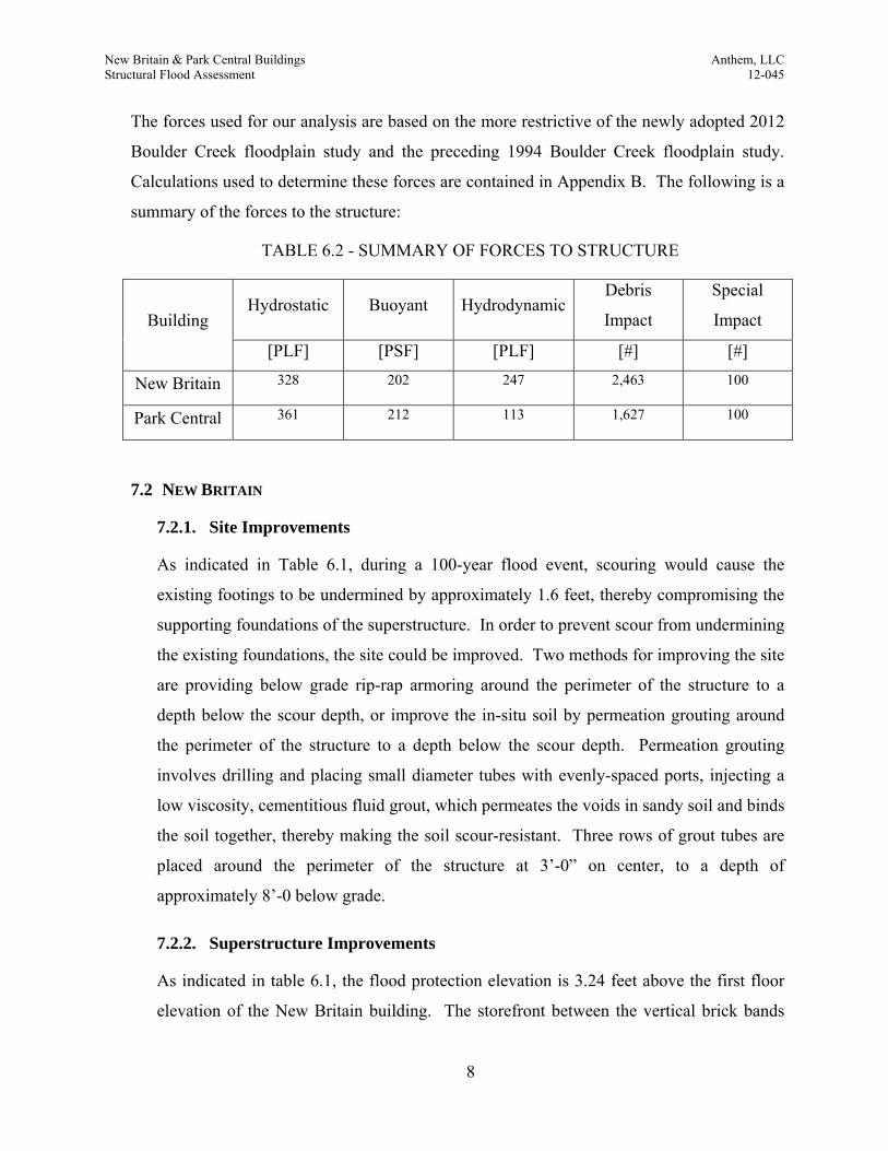
6.2 DESCRIPTION OF PARK CENTRAL BUILDING
Drawings for the Park Central building were provided by the
City of Boulder. The structure is a four-story concrete
structure consisting of a 4” concrete slab-on-grade, 8” thick,
post-tensioned concrete floor slabs and an 8” thick, post
tensioned concrete roof slab spanning 30’-0 supported by
24” deep by 16” wide exterior post-tensioned concrete
spandrel beams, and an interior central concrete beam strip
integral within the thickness of the slab. The spandrel beams
and central beam strip are supported by concrete columns –

New Britain & Park Central Buildings Anthem, LLC Structural Flood Assessment 12-045
7
16” x 16”, 16” x 14”, 14” x 20” and 14” x 24”. The concrete columns are founded on
concrete spread footings. Based on the drawings, the footings bearing elevation is 5’-0”
below the top of first floor elevation; however, during the Broadway Bridge over Boulder
Creek replacement project, these footings were observed by city personnel to be much
shallower - more on the order of 2’-6” below top of first floor elevation. There is a concrete-
enclosed stair tower at the west end of the structure and a concrete and storefront enclosed
combined stair tower and elevator shaft at the east end of the structure. Additionally, there is
a brick-faced, one story structure at the southeast corner of the structure. Analysis of the
existing restaurant at the southeast corner of the Park Central Building is not included in this
report.
7.0 FINDINGS AND REQUIRED IMPROVEMENTS
7.1 FINDINGS
The flood studies were reviewed to determine flood water elevations and velocities. This
information was used to determine the flood loads for the buildings. A preliminary scour
analysis based on the available soils information was performed in order to determine the
impacts of scouring on the existing foundation systems. The existing structures where then
analyzed for flood conditions and improvements to the buildings were designed that would
resist the flood conditions. Complete structural calculations are contained in Appendix B.
The following are summaries of our analysis results:
TABLE 6.1 - SUMMARY OF RELEVANT ELEVATIONS
Building FFE WSE FPE Δ BOF DOS Δ Ftg Δ Flr
[Ft] [Ft] [Ft] [Ft] [Ft] [Ft] [Ft] [Ft]
New Britain 5349.00 5350.24 5352.24 3.24 5344.5 5342.92 -1.58 -6.08
Park Central 5348.37 5349.77 5351.77 3.40 5345.87 5342.29 -3.58 -5.26
Elevations are expressed in NAVD88 Datum. Abbreviations: FFE = Finished Floor Elevation, WSE = Water Surface Elevation (aka Base Flood Elevation), FPE = Flood Protection Elevation, BOF = Bottom of Footing Elevation, DOS = Depth of Scour elevation.
New Britain & Park Central Buildings Anthem, LLC Structural Flood Assessment 12-045
8
The forces used for our analysis are based on the more restrictive of the newly adopted 2012
Boulder Creek floodplain study and the preceding 1994 Boulder Creek floodplain study.
Calculations used to determine these forces are contained in Appendix B. The following is a
summary of the forces to the structure:
TABLE 6.2 - SUMMARY OF FORCES TO STRUCTURE
Building Hydrostatic Buoyant Hydrodynamic
Debris
Impact
Special
Impact
[PLF] [PSF] [PLF] [#] [#]
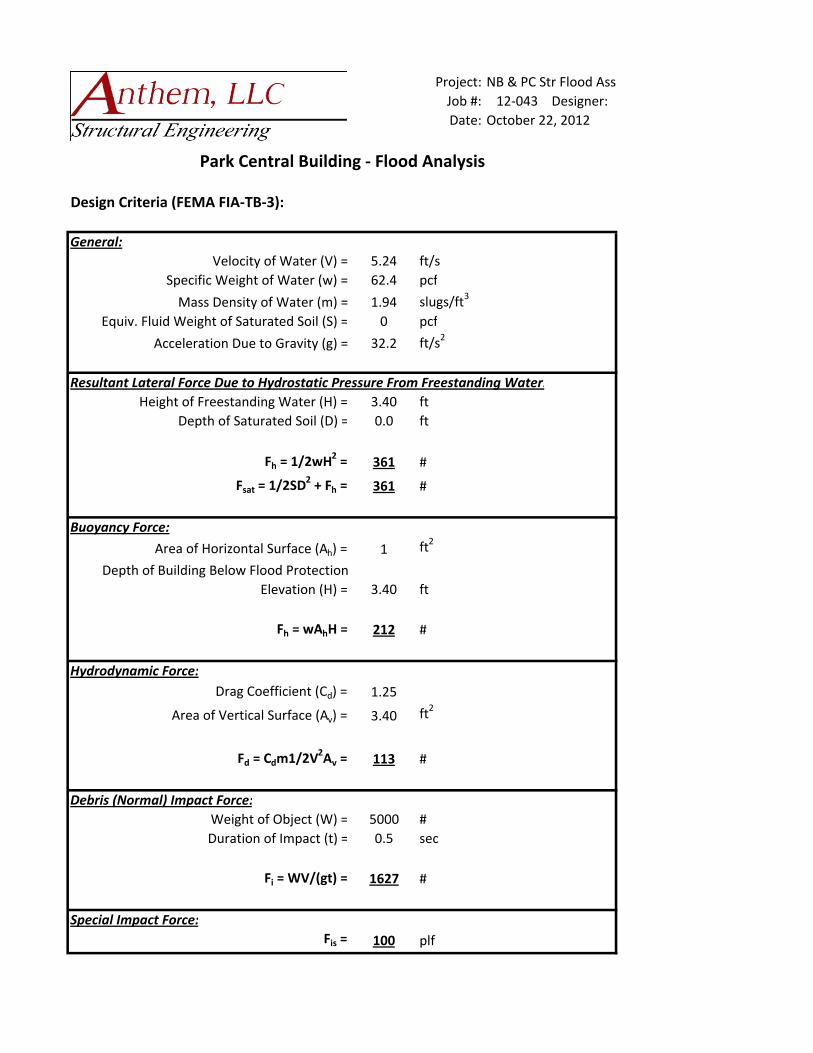
New Britain 328 202 247 2,463 100
Park Central 361 212 113 1,627 100
7.2 NEW BRITAIN
7.2.1. Site Improvements
As indicated in Table 6.1, during a 100-year flood event, scouring would cause the
existing footings to be undermined by approximately 1.6 feet, thereby compromising the
supporting foundations of the superstructure. In order to prevent scour from undermining
the existing foundations, the site could be improved. Two methods for improving the site
are providing below grade rip-rap armoring around the perimeter of the structure to a
depth below the scour depth, or improve the in-situ soil by permeation grouting around
the perimeter of the structure to a depth below the scour depth. Permeation grouting
involves drilling and placing small diameter tubes with evenly-spaced ports, injecting a
low viscosity, cementitious fluid grout, which permeates the voids in sandy soil and binds
the soil together, thereby making the soil scour-resistant. Three rows of grout tubes are
placed around the perimeter of the structure at 3’-0” on center, to a depth of
approximately 8’-0 below grade.
7.2.2. Superstructure Improvements
As indicated in table 6.1, the flood protection elevation is 3.24 feet above the first floor
elevation of the New Britain building. The storefront between the vertical brick bands

New Britain & Park Central Buildings Anthem, LLC Structural Flood Assessment 12-045
9
would need to be replaced with 8” concrete infill walls to flood protection elevation. The
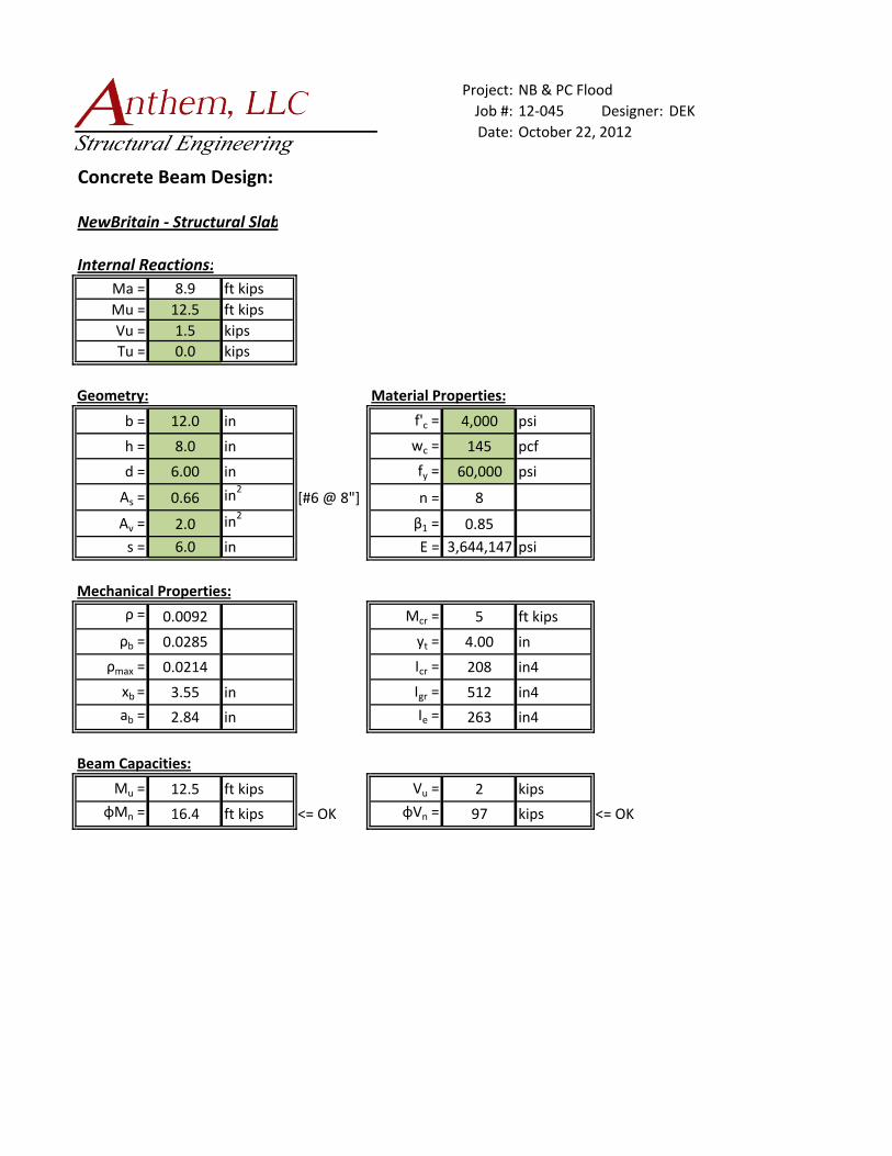
existing first floor is of wood construction, and would not be effective at resisting water
infiltration. The first floor wood framing system would need to be replaced with an 8”
thick structural concrete slab spanning from grade beam to grade beam to effectively
resist the buoyant forces and prevent water infiltration.
The elevator shaft would need to be improved to meet the requirements of FEMA FIA-
TB-4. The elevator pit would need to be waterproofed, a float switch would need to be
installed, and no electronic equipment may be located below the flood protection
elevation.
7.2.3. Opinion of Probable Cost for Structural Improvements
We estimate that the cost to floodproof the structural elements of the New Britain
building to be approximately $142,000, and the cost of site improvements to prevent
scour to be $72,800 for the rip-rap solution, and $146,000 for the permeation grouting
solution. While the cost for the rip-rap solution is less, it is a much more intrusive
solution than the permeation grouting. If the utilities are accurately located, the drilling
for the grout tubes can be located to avoid them. This cost does not include architectural
elements (such as door gaskets, membranes, elevator float switches), utility relocation,
parking slabs, relocation of employees during construction, etc.
The market value of the New Britain building structure is $1,519,000 based on $120 per
square foot. Since the costs for the required structural improvements do not exceed 50%
of the market value of the structure, and the site improvements are not considered
improvements to the building, the improvements are not considered ‘substantial
improvements’ as defined in 9-16-1 of the City of Boulder Revised Code. Although,
both structures are located in the high hazard zone based on both the 1994 study and the
2012 study, the structures are able to be improved in accordance with 9-3-5(d)(2) of the
City of Boulder Revised Code.
New Britain & Park Central Buildings Anthem, LLC Structural Flood Assessment 12-045
10
7.3 PARK CENTRAL
7.3.1. Site Improvements
As indicated in Table 6.1, during a 100-year flood event, scouring would cause the
existing footings to be undermined by approximately 3.6 feet, thereby compromising the
supporting foundations of the superstructure. In order to prevent scour from undermining
the existing foundations, the site could be improved. Two methods for improving the site
are providing below grade rip-rap armoring around the perimeter of the structure to a
depth below the scour depth, or improve the in-situ soil by permeation grouting around
the perimeter of the structure to a depth below the scour depth. Permeation grouting
involves drilling and placing small diameter tubes with evenly-spaced ports, injecting a
low viscosity, cementitious fluid grout, which permeates the voids in sandy soil and binds
the soil together, thereby making the soil scour-resistant. Three rows of grout tubes are
placed around the perimeter of the structure at 3’-0” on center, to a depth of
approximately 8’-0 below grade.
7.3.2. Superstructure Improvements
The west stair tower is enclosed in concrete and impermeable to the 100-year flood loads;
however, the door would need to be replaced with a floodproof door and the slab-on-
grade would need to be replaced with a structural slab tied into the existing concrete
walls. The slab would need to be 6” thick to resist the buoyancy pressures of 212 psf (see
table 6.2).
The east stair tower/elevator shaft is enclosed with concrete and storefront. The concrete
walls are adequate to resist flood loading, but the storefront system would need to be
replaced with either tempered glass or a concrete wall up to the flood protection elevation
of 3.4 feet above first floor, and the door would need to be replaced with a floodproof
door. The elevator shaft would need to be improved to meet the requirements of FEMA
FIA-TB-4. The elevator pit would need to be waterproofed, a float switch would need to
be installed, and no electronic equipment may be located below the flood protection
elevation.
New Britain & Park Central Buildings Anthem, LLC Structural Flood Assessment 12-045
11
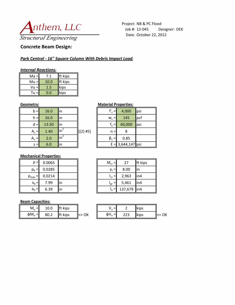
The existing columns were checked for debris impact of approximately 1,600 pounds,
based on a 5,000# truck impacting the column for a duration of ½ second at the flood
protection elevation. This criterion is more stringent than is what is required by the City
of Boulder floodplain regulations, which is a 1,000# object impacting for a duration of 1
second. The resulting internal column reactions were loaded to approximately 12% of
their capacity, as the columns are heavily reinforced (minimum of 4 - 1” diameter rebar
in a 16”x16” concrete column).
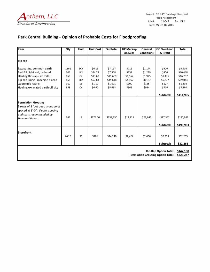
7.3.3. Opinion of Probable Cost for Structural Improvements
We estimate that the cost to floodproof the structural elements of the Park Central
building to be approximately $32,000, and the cost of site improvements to prevent scour
to be $115,000 for the rip-rap solution, and $190,000 for the permeation grouting
solution. While the cost for the rip-rap solution is less, it is a much more intrusive
solution than the permeation grouting. If the utilities are accurately located, the drilling
for the grout tubes can be located to avoid them. This cost does not include architectural
elements (such as door gaskets, membranes, elevator float switches), utility relocation or
retrofitting, parking slabs, relocation of employees during construction, etc.
The market value of the Park Central building structure is $2,430,000 based on an
assumed value of $120 per square foot. Since the costs for the required structural
improvements do not exceed 50% of the market value of the structure, and the site
improvements are not considered improvements to the building, the improvements are
not considered ‘substantial improvements’ as defined in 9-16-1 of the City of Boulder
Revised Code. Although, both structures are located in the high hazard zone based on
both the 1994 study and the 2012 study, the structures are able to be improved in
accordance with 9-3-5(d)(2) of the City of Boulder Revised Code.
8.0 CONCLUSIONS
After conducting our assessment, we have concluded that the buildings as constructed are not
able to withstand the 100-year flood event without improving the structures. Based on the flood
and soil parameters for the site, the foundations of both buildings would be undermined due to
scour, which would result in the collapse of the structures. The improvements that would be
New Britain & Park Central Buildings Anthem, LLC Structural Flood Assessment 12-045
12
required to floodproof the existing structures excluding site improvements are approximately
$31,000 for the Park Central Building and $142,000 for the New Britain Building. The costs for
the site improvements that would be required to prevent the foundations from being undermined
range from $115,000 to $190,000 for the Park Central Building and $72,800 to $146,000. As
mentioned elsewhere in the report, there would be costs incurred in addition to the required
structural improvements, including the possible relocation of underground utilities.
Since the costs for the required structural improvements do not exceed 50% of the market value
of the structure, and the site improvements are not considered improvements to the building, the
improvements are not considered ‘substantial improvements’ as defined in 9-16-1 of the City of
Boulder Revised Code, and are therefore permitted.
9.0 REFERENCES
The following published references were used in the preparation of this report:
Federal Emergency Management Agency: Technical Bulletin 3: Non-Residential Floodproofing-Requirements and Certification for Buildings Located in Special Flood Hazard Area, 1993
Federal Emergency Management Agency: FEMA-102: Floodproofing Non-Residential Structures, May 1986.
Federal Emergency Management Agency: FEMA-114: Design Manual for Retrofitting Flood-Prone Residential Structures, September 1986.
Federal Emergency Management Agency: FIA-TB-4: Elevator Installation for Buildings Located in Special Flood Hazard Areas
Colorado State University: Colorado State University Pier Scour Equation (modified from Richardson and others), 1993.
Reed Construction Data: RSMeans Online

AppendixA
FloodStudyInformation

54.4
56
55
54.454.154.3
54.2
54.5
51.12
56.1
51.02
50.151.01
903
3111
56.2
50.2
56.15
49.5
900
2977
2830
2444
2576
11th St
Arapahoe Av
13th St
Marine St
Walnut St
Broadway
Canyon Bv
11th St
Broadway Canyon Bv
13th St
Broadway
11th St
11th St
Canyon Bv
Arapahoe Av
Walnut St
Broadway
Broadway
Arapahoe Av
Broadway
Canyon Bv
Boulder Creek
±City of Boulder
1994 Boulder CreekFloodplain Study160 0 16080 Feet
LegendFlood Cross SectionsHigh Hazard Flood ZoneFlood Conveyence ZoneCity 100 Year Flood Plain


Æ
Æ
BLVD
1
ARA
30759
30635
30420
30335 29994
5829
5902
City LimitsLakesFlood work in progress 500 YearFlood work in progress 100 YearFlood work in progress ConveyanceFlood work in progress High HazardFlood work in progress X Sections
Æ Flood Elevation Certificates
Ownership Parcels
Creeks & DitchesCreekIntermitent CreekDitchDitch LateralAqueductTailwater
Survey PolygonsStreet Centerlines
Main RoadsArterialHighway
Building FootprintsText Street Names
2012 Floodplain Study
1:1200
NThe information depicted on this map is provided as graphical representation only. The City of Boulder provides no warranty, expressed or implied, as to the accuracy and/or completeness of the informationcontained hereon.
LEGEND
MapLinkCity of Boulder GIS
Sat 06 Oct 2012 10:29
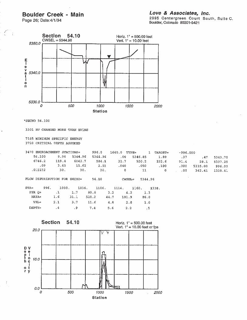
Plan: 100yr Taft Boulder Creek Broadway-Arap RS: 30420 Profile: 100-Year
E.G. Elev (ft) 5350.19 Element Left OB Channel Right OB
Vel Head (ft) 0.42 Wt. n-Val. 0.040 0.040 0.024
W.S. Elev (ft) 5349.77 Reach Len. (ft) 1.00 1.00 1.00
Crit W.S. (ft) 5347.60 Flow Area (sq ft) 4.56 987.92 711.86
E.G. Slope (ft/ft) 0.001430 Area (sq ft) 5.74 1307.10 762.46
Q Total (cfs) 8888.98 Flow (cfs) 2.68 5159.00 3727.30
Top Width (ft) 418.37 Top Width (ft) 19.37 171.00 228.00
Vel Total (ft/s) 5.22 Avg. Vel. (ft/s) 0.59 5.22 5.24
Max Chl Dpth (ft) 11.77 Hydr. Depth (ft) 0.28 8.90 3.36
Conv. Total (cfs) 235052.8 Conv. (cfs) 70.8 136420.3 98561.7
Length Wtd. (ft) 1.00 Wetted Per. (ft) 16.86 137.84 225.40
Min Ch El (ft) 5338.00 Shear (lb/sq ft) 0.02 0.64 0.28
Alpha 1.00 Stream Power (lb/ft s) 0.01 3.34 1.48
Frctn Loss (ft) Cum Volume (acre-ft) 1.83 12.78 1.85
C & E Loss (ft) Cum SA (acres) 0.43 1.24 0.43

0 200 400 600 800 10005335
5340
5345
5350
5355
5360
5365
5370
5375
COBLDR02 Plan: 100-yr w/o Roche (Harvest House Taft) 6/29/2011 US Side of Broadway. Overbanks of xsec cut using HecGeoRAS from
Station (ft)
Ele
vatio
n (f
t)
Legend
EG 100-Year
WS 100-Year
Crit 100-Year
Ground
Ineff
Bank Sta
.03
.04 .04 .05
.025 .02 .04
Plan: 100yr Taft Boulder Creek 6th-Broadway RS: 30635 Profile: 100-Year
E.G. Elev (ft) 5351.38 Element Left OB Channel Right OB
Vel Head (ft) 1.14 Wt. n-Val. 0.027 0.040 0.025
W.S. Elev (ft) 5350.24 Reach Len. (ft)
Crit W.S. (ft) 5350.24 Flow Area (sq ft) 249.22 793.08 381.91
E.G. Slope (ft/ft) 0.008116 Area (sq ft) 256.68 793.08 381.91
Q Total (cfs) 12000.00 Flow (cfs) 1700.51 7272.42 3027.07
Top Width (ft) 590.81 Top Width (ft) 194.08 173.85 222.88
Vel Total (ft/s) 8.43 Avg. Vel. (ft/s) 6.82 9.17 7.93
Max Chl Dpth (ft) 7.24 Hydr. Depth (ft) 1.44 4.56 1.71
Conv. Total (cfs) 133199.6 Conv. (cfs) 18875.6 80723.6 33600.4
Length Wtd. (ft) Wetted Per. (ft) 176.35 174.86 228.47
Min Ch El (ft) 5343.00 Shear (lb/sq ft) 0.72 2.30 0.85
Alpha 1.03 Stream Power (lb/ft s) 4.89 21.07 6.71
Frctn Loss (ft) 0.70 Cum Volume (acre-ft) 0.61 3.92 1.85
C & E Loss (ft) 0.36 Cum SA (acres)

0 200 400 600 800 1000 1200 1400 1600 18005340
5345
5350
5355
5360
5365
5370
5375
COBLDR02 Plan: 100-yr w/o Roche (Harvest House Taft) 6/29/2011 Xsec cut using HecGeoRAS from 1-foot Topography
Station (ft)
Ele
vatio
n (f
t)
Legend
EG 100-Year
WS 100-Year
Crit 100-Year
Ground
Ineff
Bank Sta
.04 .02 .04 .02 .04 .04 .04
.025 .02
.025 .04
AppendixB
StructuralCalculations

Project:
Job #: 12‐045 DEK
Date:
Geotechnical Report:
Geotechnical Engineer N/A
Report Number N/A
Report Date N/A
Soil Data:
Maximum End Bearing Pressure 25 ksf
Side Shear ‐ Gravity 2.5 ksf
Side Shear ‐ Uplift 2.5 ksf
Side Shear Minimum DL 0 ksf
Minimum DL End Bearing Pressure 0 ksf
Minimum Penetration into Bedrock 15 ft
Top Bedrock Penetration to be Ignored 2 ft
Uplift Sideshear Stress 0 ksf
Uplift Sideshear Length 0 ft
Specified Minimum Pier Length 35 ft
Concrete Strength: f'c = 4 ksi
Pier Diameter in 10 12 14 16 18 20 24 30 36 42 48
End Area ft2 0.545 0.785 1.069 1.396 1.767 2.182 3.142 4.909 7.069 9.621 12.57
Surface Area ft2/ft 2.618 3.142 3.665 4.189 4.712 5.236 6.283 7.854 9.425 11 12.57
φPn/U (ACI 10‐2) kips 154.2 215.3 287.5 370.8 465.2 570.8 815.2 1265 1815 2465 3215
0.005xA in2 0.393 0.565 0.77 1.005 1.272 1.571 2.262 3.534 5.089 6.927 9.048
Bar Size 5 2 2 3 4 5 6 8 12 17 23 30
Pier Diameter (in) 10 12 14 16 18 20 24 30 36 42 48
1/2φPn/U 77 108 144 185 233 285 408 633 907 1232 1607
Bedrock Penetration (ft) 15 99 122 146 171 197 225 283 378 483 598 723
16 105 130 155 182 209 238 298 398 507 625 754
17 112 137 164 192 221 251 314 417 530 653 785
18 118 145 173 202 233 264 330 437 554 680 817
19 125 153 182 213 244 277 346 457 577 708 848
20 131 161 192 223 256 290 361 476 601 735 880
21 138 169 201 234 268 303 377 496 624 763 911
22 145 177 210 244 280 316 393 515 648 790 942
23 151 185 219 255 292 329 408 535 672 818 974
24 158 192 228 265 303 343 424 555 695 845 1005
> 1/2φPn/U
Side Shear (k/ft) 6.545 7.854 9.163 10.47 11.78 13.09 15.71 19.63 23.56 27.49 31.42
Min DL Force (kips) 0 0 0 0 0 0 0 0 0 0 0
Side Shear (min DL) (k/ft) 0 0 0 0 0 0 0 0 0 0 0
Uplift Force (kips) 20.83 25 29.17 33.33 37.5 41.67 50 62.5 75 87.5 100
Side Shear (Uplift) (k/ft) 0 0 0 0 0 0 0 0 0 0 0
Side Shear Capacities:
NB & PC Structural Flood Study
Designer:
October 11, 2012
Drilled Pier Properties:
Drilled Pier Capacities (kips):

Project:
Job #: 12‐043 Designer: DEK
Date:
Design Criteria (FEMA FIA‐TB‐3):
General:
Velocity of Water (V) = 7.93 ft/s
Specific Weight of Water (w) = 62.4 pcf
Mass Density of Water (m) = 1.94 slugs/ft3
Equiv. Fluid Weight of Saturated Soil (S) = 0 pcf
Acceleration Due to Gravity (g) = 32.2 ft/s2
Resultant Lateral Force Due to Hydrostatic Pressure From Freestanding Water:
Height of Freestanding Water (H) = 3.24 ft
Depth of Saturated Soil (D) = 0.0 ft
Fh = 1/2wH2 = 328 #
Fsat = 1/2SD2 + Fh = 328 #
Buoyancy Force:
Area of Horizontal Surface (Ah) = 1.00 ft2
3.24 ft
Fh = wAhH = 202 #
Hydrodynamic Force:
Drag Coefficient (Cd) = 1.25
Area of Vertical Surface (Av) = 3.24 ft2
Fd = Cdm1/2V2Av = 247 #
Debris (Normal) Impact Force:
Weight of Object (W) = 5000 #
Duration of Impact (t) = 0.5 sec
Fi = WV/(gt) = 2463 #
Special Impact Force:
Fis = 100 plf
NB & PC Str Flood Assessment
Depth of Building Below Flood Protection
Elevation (H) =
New Britain Building ‐ Flood Analysis
October 22, 2012

Project: NB & PC Str Flood Assessment
Job #: 12‐043 Designer: DEK
Date: October 22, 2012
Colorado State University Pier Scour Equation (Modified from Richardson, 1993):
y /y = 2K K K (a/y )0.65F 0.43
New Britain Building ‐ Scour Analysis
ys/y1 = 2K1K2K3(a/y1)0.65Fr
0.43
ys = 6.09 Feet Depth of Scour
y1 = 3.24 Feet Upstream Flow Depth
K1 = 1 Pier Nose Shape Correction Factor (Dimensionless)K1 1 Pier Nose Shape Correction Factor (Dimensionless)
K2 = 1 Skew Correction Factor (Dimensionless) ‐ (cosθ + L/a sinθ)0.65
K3 = 1.1 Bed Form Correction Factor (Dimensionless)
a = 3 Feet Width of Pier
Fr = 0.78 Froude Number ‐ (Fr = Ve/(gya)1/2)
θ = 90 Degrees Angle of Attack of Flow
Ve = 7.93 Ft/sec Average Velocity of Flow
Correction Factor, K 3 For Bed FormCorrection Factor, K 1 For Pier Nose Shape
K1 Dune Height H K3
[Feet]
Square Nose 1.1 N/A 1.1
Round Nose 1.0 N/A 1.1
Shape of Pier Nose Shape of Pier Nose
Clear Water Scour
Plane Bed & Antidun Flow
Circular Cylinder 1.0 10 > H > 2 1.1
Group of Cylinders 1.0 30 > H > 10 1.1 to 1.2
Sharp Nose 0.9 H > 30 1.3
Small Dunes
Medium Dunes
Large Dunes
Project:
Job #: 12‐043 Designer:
Date:
Design Criteria (FEMA FIA‐TB‐3):
General:
Velocity of Water (V) = 5.24 ft/s
Specific Weight of Water (w) = 62.4 pcf
Mass Density of Water (m) = 1.94 slugs/ft3
Equiv. Fluid Weight of Saturated Soil (S) = 0 pcf
Acceleration Due to Gravity (g) = 32.2 ft/s2
Resultant Lateral Force Due to Hydrostatic Pressure From Freestanding Water:
Height of Freestanding Water (H) = 3.40 ft
Depth of Saturated Soil (D) = 0.0 ft
Fh = 1/2wH2 = 361 #
Fsat = 1/2SD2 + Fh = 361 #
Buoyancy Force:
Area of Horizontal Surface (Ah) = 1 ft2
3.40 ft
Fh = wAhH = 212 #
Hydrodynamic Force:
Drag Coefficient (Cd) = 1.25
Area of Vertical Surface (Av) = 3.40 ft2
Fd = Cdm1/2V2Av = 113 #
Debris (Normal) Impact Force:
Weight of Object (W) = 5000 #
Duration of Impact (t) = 0.5 sec
Fi = WV/(gt) = 1627 #
Special Impact Force:
Fis = 100 plf
NB & PC Str Flood Ass
October 22, 2012
Park Central Building ‐ Flood Analysis
Depth of Building Below Flood Protection
Elevation (H) =
Project: NB & PC Str Flood Assessment
Job #: 12‐043 Designer: DEK
Date: October 22, 2012
Colorado State University Pier Scour Equation (Modified from Richardson, 1993):
y /y = 2K K K (a/y )0.65F 0.43
Park Central Building ‐ Scour Analysis
ys/y1 = 2K1K2K3(a/y1)0.65Fr
0.43
ys = 5.12 Feet Depth of Scour
y1 = 3.4 Feet Upstream Flow Depth
K1 = 1 Pier Nose Shape Correction Factor (Dimensionless)K1 1 Pier Nose Shape Correction Factor (Dimensionless)
K2 = 1 Skew Correction Factor (Dimensionless) ‐ (cosθ + L/a sinθ)0.65
K3 = 1.1 Bed Form Correction Factor (Dimensionless)
a = 3 Feet Width of Pier
Fr = 0.5 Froude Number ‐ (Fr = Ve/(gya)1/2)
θ = 90 Degrees Angle of Attack of Flow
Ve = 5.24 Ft/sec Average Velocity of Flow
Correction Factor, K 3 For Bed FormCorrection Factor, K 1 For Pier Nose Shape
K1 Dune Height H K3
[Feet]
1.1 N/A 1.1
1.0 N/A 1.1
Shape of Pier Nose
Square Nose
Round Nose
Shape of Pier Nose
Clear Water Scour
Plane Bed & Antidun Flow
1.0 10 > H > 2 1.1
1.0 30 > H > 10 1.1 to 1.2
0.9 H > 30 1.3Large Dunes
Circular Cylinder
Group of Cylinders
Sharp Nose
Small Dunes
Medium Dunes
Project:
Job #: 12‐045 Designer: DEK
Date:
Concrete Beam Design:
NewBritain ‐ Structural Slab
Internal Reactions:
Ma = 8.9 ft kips
Mu = 12.5 ft kips
Vu = 1.5 kips
Tu = 0.0 kips
Geometry: Material Properties:
b = 12.0 in f'c = 4,000 psi
h = 8.0 in wc = 145 pcf
d = 6.00 in fy = 60,000 psi
As = 0.66 in2 [#6 @ 8"] n = 8
Av = 2.0 in2 β1 = 0.85
s = 6.0 in E = 3,644,147 psi
Mechanical Properties:
ρ = 0.0092 Mcr = 5 ft kips
ρb = 0.0285 yt = 4.00 in
ρmax = 0.0214 Icr = 208 in4
xb = 3.55 in Igr = 512 in4
ab = 2.84 in Ie = 263 in4
Beam Capacities:
Mu = 12.5 ft kips Vu = 2 kips
φMn = 16.4 ft kips <= OK φVn = 97 kips <= OK
NB & PC Flood
October 22, 2012
Project:
Job #: 12‐045 Designer: DEK
Date:
Concrete Beam Design:
Park Central ‐ 16" Square Column With Debris Impact Load:
Internal Reactions:
Ma = 7.1 ft kips
Mu = 10.0 ft kips
Vu = 1.5 kips
Tu = 0.0 kips
Geometry: Material Properties:
b = 16.0 in f'c = 4,000 psi
h = 16.0 in wc = 145 pcf
d = 13.50 in fy = 60,000 psi
As = 1.40 in2 [(2) #5] n = 8
Av = 2.0 in2 β1 = 0.85
s = 6.0 in E = 3,644,147 psi
Mechanical Properties:
ρ = 0.0065 Mcr = 27 ft kips
ρb = 0.0285 yt = 8.00 in
ρmax = 0.0214 Icr = 2,963 in4
xb = 7.99 in Igr = 5,461 in4
ab = 6.39 in Ie = 137,679 in4
Beam Capacities:
Mu = 10.0 ft kips Vu = 2 kips
φMn = 80.2 ft kips <= OK φVn = 223 kips <= OK
NB & PC Flood
October 22, 2012

AppendixC
HistoricSoilBoringLogs

AppendixD
OpinionofProbableCost

Project: NB & PC Buildings Structural
Flood Assessment
Job #: 12‐045 By: DEK
Date:
New Britain Building ‐ Opinion of Probable Costs for Floodproofing
Item Qty Unit Unit Cost Subtotal GC Markup General GC Overhead Totalon Subs Conditions & Profit
Rip rap
Excavating, common earth 863 BCY $6.13 $5,290 $529 $873 $669 $7,361
Backfill, light soil, by hand 390 LCY $24.78 $9,664 $966 $1,595 $1,223 $13,448
Hauling Rip‐rap ‐ 20 miles 473 CY $13.60 $6,433 $643 $1,061 $814 $8,951
Rip‐rap lining ‐ machine placed 473 LCY $57.83 $27,354 $2,735 $4,513 $3,460 $38,063
Geotextile Fabric 390 SY $1.10 $429 $43 $71 $54 $597
Hauling excavated earth off site 473 CY $6.60 $3,122 $312 $515 $395 $4,344
Subtotal: $72,764
Permiation Grouting
280 LF $375.00 $105,000 $10,500 $17,325 $13,283 $146,108
Subtotal: $146,108
104.0 CY $612 $63,648 $6,365 $10,502 $8,051 $88,566
Subtotal: $88,566
Concrete Wall Infill12.7 CY $398 $5,055 $505 $834 $639 $7,033
Subtotal: $7,033
Storefront346.0 SF $101 $34,946 $3,495 $3,844 $4,228 $46,513
Subtotal: $46,513
Rip‐Rap Option Total: $214,877Permiation Grouting Option Total: $288,220
March 18, 2013
3 rows of 8 foot deep grout ports
spaced at 3'‐0". Depth, spacing
and costs recommended by
Hayward Baker
Reinforced Concrete Structural
Slab
Project: NB & PC Buildings Structural
Flood Assessment
Job #: 12‐045 By: DEK
Date:
Park Central Building ‐ Opinion of Probable Costs for Floodproofing
Item Qty Unit Unit Cost Subtotal GC Markup General GC Overhead Totalon Subs Conditions & Profit
Rip rap
Excavating, common earth 1161 BCY $6.13 $7,117 $712 $1,174 $900 $9,903
Backfill, light soil, by hand 303 LCY $24.78 $7,508 $751 $1,239 $950 $10,448
Hauling Rip‐rap ‐ 20 miles 858 CY $13.60 $11,669 $1,167 $1,925 $1,476 $16,237
Rip‐rap lining ‐ machine placed 858 LCY $57.83 $49,618 $4,962 $8,187 $6,277 $69,044
Geotextile Fabric 910 SY $1.10 $1,001 $100 $165 $127 $1,393
Hauling excavated earth off site 858 CY $6.60 $5,663 $566 $934 $716 $7,880
Subtotal: $114,905
Permiation Grouting
366 LF $375.00 $137,250 $13,725 $22,646 $17,362 $190,983
Subtotal: $190,983
Storefront240.0 SF $101 $24,240 $2,424 $2,666 $2,933 $32,263
Subtotal: $32,263
Rip‐Rap Option Total: $147,168Permiation Grouting Option Total: $223,247
March 18, 2013
3 rows of 8 foot deep grout ports
spaced at 3'‐0". Depth, spacing
and costs recommended by
Hayward Baker