Embed Size (px)
Citation preview

Estudios Geol., 51: 43-55 (1995)
STRUCTURE OF SIERRA BLANCA (ALPUJARRIDE COMPLEX,WEST OF THE BETIC CORDILLERA)
C. Sanz de Galdeano * and B. Andreo **
ABSTRACT
Sierra Blanca, situated in the SW of Málaga, forms part of the Blanca unit, belongingto the Alpujarride Complex of the Betic Cordillera. Its lithologic sequences are made upof a group of migmatites, gneisses and schists and an upper formation of marbles (whitedolomitic and the bottom and blue calcareous towards the top), linked with a transitionalcontact.
The structure of Sierra Blanca is comprised of folds, generally isoclinal, with reversed limbs and with important tectonic transpositions, the direction of which is approximately E-W in the eastern area and N-S and E-W in the West. In both areas the foldspresent opposing vergences, consistently towards the interior of the sierra. The origin ofthese structures is explained with a model of westerly movements of the Blanca unit, inrelation to the Los Reales unit, with the formation of frontal and lateral folds. In itsadvancement, the western part of Sierra Blanca underwent an important anti-clockwiserotation responsible for the co-existence of folds in N-S and E-W directions. These structures occurred under ductile conditions, owing to the presence of important overthrustingperidotitic masses of the Los Reales unit. This model of westerly displacement is inserted in the process undergone by the Betic-Rif Internal Zones (with Blanca and Los Reales units included) which occurred at the end of the Oligocene-Early Miocene when theGibraltar arch began to be formed.
Key words: Alpujarride, Betic Cordillera, folds, ductile structures.
RESUMEN
Sierra Blanca, situada al SW de Málaga, forma parte de la unidad de Blanca que pertenece al complejo Alpujárride de la Cordillera Bética. Su secuencia litológica está compuesta por un conjunto inferior de migmatitas, gneises y esquistos, y por una formaciónsuperior de mármoles, blancos dolomíticos en la base y mármoles calizos azules hacia laparte superior, entre los que existe un tránsito gradual.
La estructura de Sierra Blanca está formada por pliegues, generalmente isoclinales,con flancos invertidos que muestran importantes evidencias de estiramiento tectónico.Estos pliegues tienen una dirección aproximada E-W en el sector oriental y N-S y E-Wen el occidental. En los bordes de ambos sectores los pliegues muestran vergenciasopuestas, siempre hacia el interior de la sierra. El origen de esta estructura se explica conun modelo que considera un desplazamiento hacia el oeste de la unidad de Blanca, conrespecto a la de Los Reales, formándose pliegues en posición frontal y lateral. En suavance la parte occidental de Sierra Blanca sufrió una importante rotación antihoraria,responsable de la coexistencia de los pliegues de direcciones N-S y E-W. La estructurase formó en condiciones dúctiles, a causa de la presencia de importantes masas peridotíticas de la unidad de Los Reales cabalgante. Este modelo de desplazamientos hacia el Wse inserta en los desplazamientos sufridos por las Zonas Internas Bético-Rifeñas (con lasunidades de Blanca y de Los Reales incluidas) durante finales del Oligoceno y el Mioceno inferior, cuando comenzó a formarse el arco de Gibraltar.
Palabras clave: Alpujárride. Cordillera Bética. pliegues, estructuras dúctiles.
* Instituto Andaluz de Ciencias de la Tierra (CSIC-Universidad de Granada). Facultad de Ciencias. 18071 Granada (Spain).** Departamento de Geología. Facultad de Ciencias. Universidad. 29071 Málaga (Spain).
44
Introduction
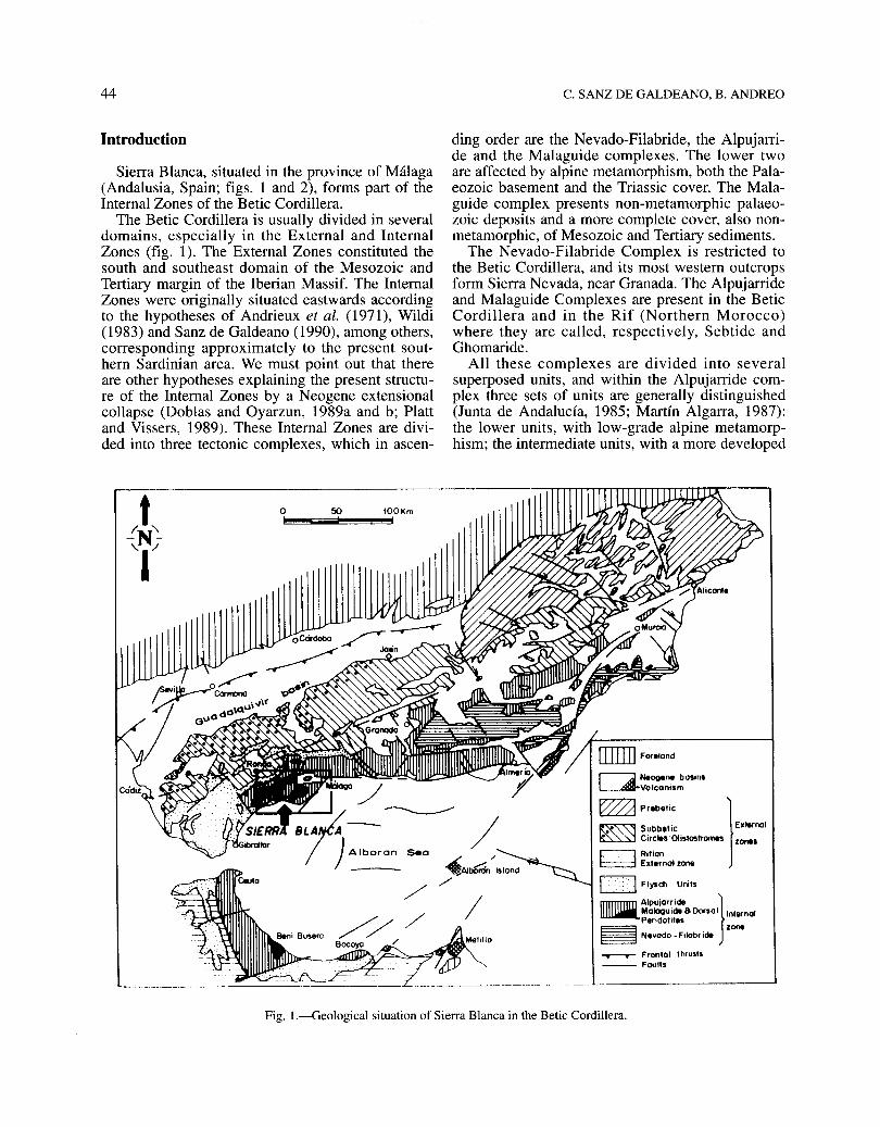
Sierra Blanca, situated in the province of Málaga(Andalusia, Spain; figs. 1 and 2), forms part of theInternal Zones of the Betic Cordillera.
The Betic Cordillera is usually divided in severaldomains, especiaHy in the External and InternalZones (fig. 1). The External Zones constituted thesouth and southeast domain of the Mesozoic andTertiary margin of the Iberian Massif. The InternalZones were originally situated eastwards accordingto the hypotheses of Andrieux et al. (1971), Wildi(1983) and Sanz de Galdeano (1990), among others,corresponding approximately to the present southern Sardinian area. We must point out that thereare other hypotheses explaining the present structure of the Internal Zones by a Neogene extensionalcollapse (Doblas and Oyarzun, 1989a and b; Plattand Vissers, 1989). These Internal Zones are divided into three tectonic complexes, which in ascen-
o 50 100Kmel!!'!!"'!!§;ii;;¡¡;;l!I!!'!!"'!!!!"!!!!!"!!!!!!I1
C. SANZ DE GALDEANO, B. ANDREO
ding order are the Nevado-Filabride, the Alpujarride and the Malaguide complexes. The lower twoare affected by alpine metamorphism, both the Palaeozoic basement and the Triassic cover. The Malaguide complex presents non-metamorphic palaeozoic deposits and a more complete cover, also nonmetamorphic, of Mesozoic and Tertiary sediments.
The Nevado-Filabride Complex is restricted tothe Betic Cordillera, and its most western outcropsform Sierra Nevada, near Granada. The Alpujarrideand Malaguide Complexes are present in the BeticCordillera and in the Rif (Northern Morocco)where they are caHed, respectively, Sebtide andGhomaride.
AH these complexes are divided into severalsuperposed units, and within the Alpujarride complex three sets of units are generally distinguished(Junta de Andalucía, 1985; Martín Algarra, 1987):the lower units, with low-grade alpine metamorphism; the intermediate units, with a more developed
r--:;;¡ NeOll808 bosins~Volconism
~pr.b.IiC 1• Subb.'ic EKMrool~ Circles'Otislaslrame. lones
¡::::::=::=::¡ Riflont:::=:.:::t Externo' Ion.
¡.... :.:.:.:..¡ Flysch Unil.
mmmnn Alpujorride }~Mologulde800rsol Inl.rnol
Perídolil••~ lone~_ N.vodo-F.labride
~ Fronfol Ih,usl1-- Foulls
Fig. l.-Geological situation of Sierra Blanca in the Betic Cordillera.
STRUCTURE OF SIERRA BLANCA (BETIC CORDILLERA)
N
-~-____10 Km
CJ Tertiory 8 Quoternary ~ Dorsal omn Alpujarride
~ Penibetic (Ex.ternalzone) fi:m MoloQuide § Peridotitel
--..-- Thru5f ~ Normal faull Strike - slip faull
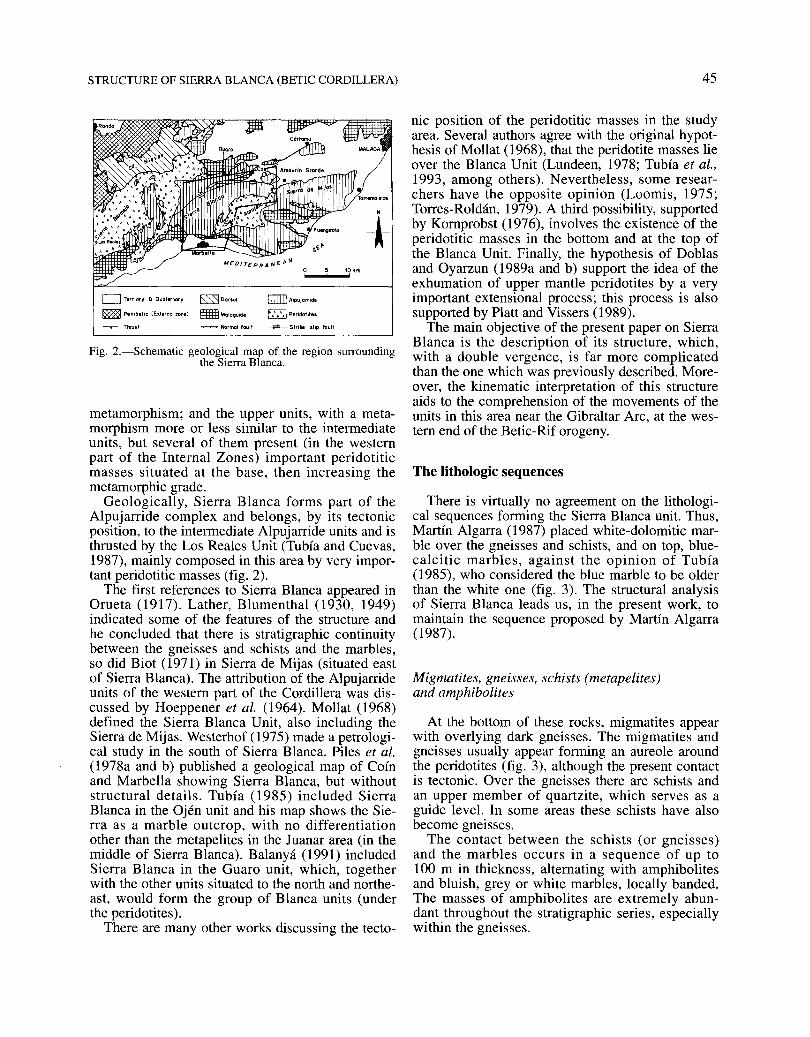
Fig. 2.-Schematic geological map of the region surroundingthe Sierra Blanca.
metamorphism; and the upper units, with a metamorphism more or less similar to the intermediateunits, but several of them present (in the westernpart of the Internal Zones) important peridotiticmasses situated at the base, then increasing themetamorphic grade.
Geological1y, Sierra Blanca forms part of theAlpujarride complex and belongs, by its tectonicposition, to the intermediate Alpujarride units and isthrusted by the Los Reales Unit (Tubía and Cuevas,1987), mainly composed in this area by very important peridotitic masses (fig. 2).
The first references to Sierra Blanca appeared inOrueta (1917). Lather, Blumenthal (1930, 1949)indicated sorne of the features of the structure andhe concluded that there is stratigraphic continuitybetween the gneisses and schists and the marbles,so did Biot (1971) in Sierra de Mijas (situated eastof Sierra Blanca). The attribution of the Alpujarrideunits of the western part of the Cordillera was discussed by Hoeppener et al. (1964). Mol1at (1968)defined the Sierra Blanca Unit, also including theSierra de Mijas. Westerhof (1975) made a petrological study in the south of Sierra Blanca. Piles et al.(1978a and b) published a geological map of Coínand Marbella showing Sierra Blanca, but withoutstructural details. Tubía (1985) included SierraBlanca in the Ojén unit and his map shows the Sierra as a marble outcrop, with no differentiationother than the metapelites in the Juanar area (in themiddle of Sierra Blanca). Balanyá (1991) includedSierra Blanca in the Guaro unit, which, togetherwith the other units situated to the north and northeast, would form the group of Blanca units (underthe peridotites).
There are many other works discussing the tecto-
45
nic position of the peridotitic masses in the studyarea. Several authors agree with the original hypothesis of Mollat (1968), that the peridotite masses lieover the Blanca Unit (Lundeen, 1978; Tubía et al.,1993, among others). Nevertheless, sorne researchers have the opposite opinion (Loomis, 1975;Torres-Roldán, 1979). A third possibility, supportedby Kornprobst (1976), involves the existence of theperidotitic masses in the bottom and at the top ofthe Blanca Unit. Final1y, the hypothesis of Doblasand Oyarzun (l989a and b) support the idea of theexhumation of upper mantle peridotites by a veryimportant extensional process; this process is alsosupported by Platt and Vissers (1989).
The main objective of the present paper on SierraBlanca is the description of its structure, which,with a double vergence, is far more complicatedthan the one which was previously described. Moreover, the kinematic interpretation of this structureaids to the comprehension of the movements of theunits in this area near the Gibraltar Arc, at the western end of the Betic-Rif orogeny.
The lithologic sequences
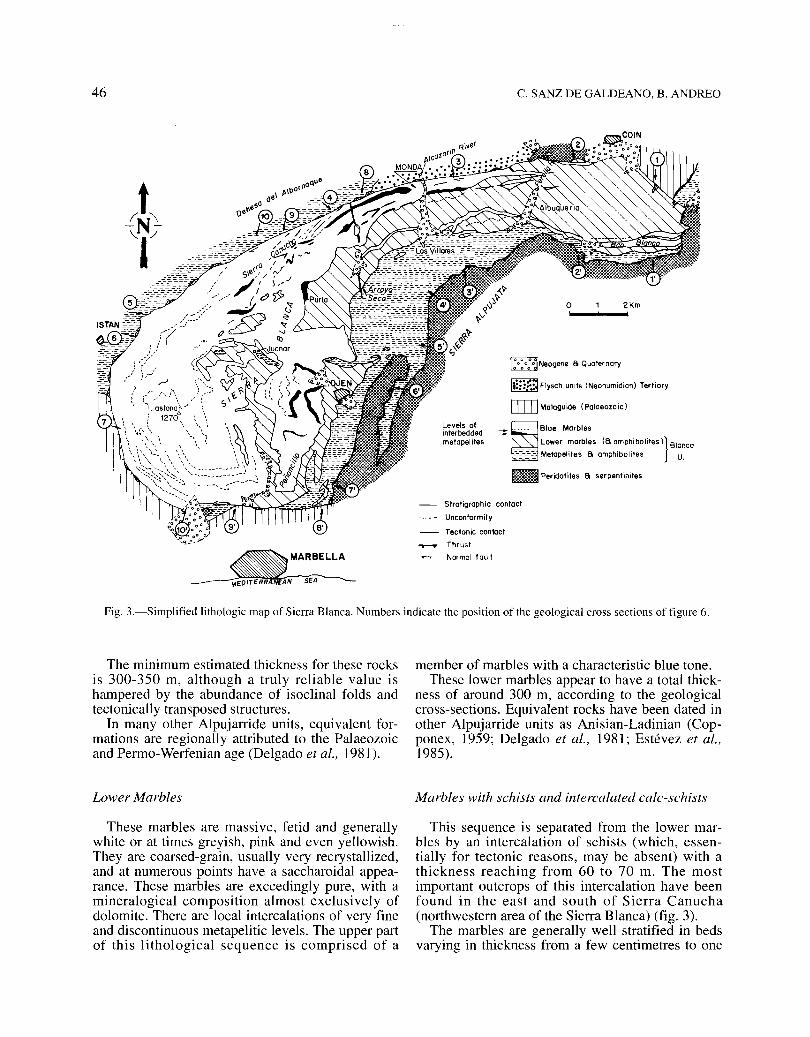
There is virtually no agreement on the lithological sequences forming the Sierra Blanca unit. Thus,Martín AIgarra (1987) placed white-dolomitic marble over the gneisses and schists, and on top, bluecalcitic marbles, against the opinion of Tubía(1985), who considered the blue marble to be olderthan the white one (fig. 3). The structural analysisof Sierra Blanca leads us, in the present work, tomaintain the sequence proposed by Martín AIgarra(1987).
Migmatites, gneisses, schists (metapelites)and amphibolites
At the bottom of these rocks, migmatites appearwith overlying dark gneisses. The migmatites andgneisses usually appear forming an aureole aroundthe peridotites (fig. 3), although the present contactis tectonic. Over the gneisses there are schists andan upper member of quartzite, which serves as aguide leve!. In sorne areas these schists have alsobecome gneisses.
The contact between the schists (or gneisses)and the marbles occurs in a sequence of up to100 m in thickness, alternating with amphibolitesand bluish, grey or white marbles, locally banded.The masses of amphibolites are extremely abundant throughout the stratigraphic series, especiallywithin the gneisses.
46 C. SANZ DE GALDEANO, B. ANDREO
- Slraligraphie eonlael
-- - - Unconformity
- Tectonic conteet
........... Thrusl
Normol faul!
lt:::~Flysch units (Neonumidian) Tertiary
[]]] Malagu ide (Palaeazo ie)
_ ~.... Blue Marbles
- Lower marbles (8 amphiboliles l} Blanca
::f=~'" Melapeliles 8 amphibollles U.
_ Peridotites a serpentinites
MAR BELLA
Levels ofinlerbeddedmetapelites
o,
~~Neogene 8 Quaternary
2Km
Fig. 3.-Simplified lithologic map of Sierra Blanca. Numbers indicate the position of the geological cross sections of figure 6.
The minimum estimated thickness for these rocksis 300-350 m, although a truly reliable value ishampered by the abundance of isoclinal folds andtectonically transposed structures.
In many other Alpujarride units, equivalent formations are regionally attributed to the Palaeozoicand Permo-Werfenian age (Delgado et al., 1981).
Lower Marbles
These marbles are massive, fetid and generallywhite or at times greyish, pink and even yellowish.They are coarsed-grain, usually very recrystallized,and at numerous points have a saccharoidal appearance. These marbles are exceedingly pure, with amineralogical composition almost exclusively ofdolomite. There are local intercalations of very fineand discontinuous metapelitic levels. The upper partof this lithological sequence is comprised of a
member of marbles with a characteristic blue tone.These lower marbles appear to have a total thick
ness of around 300 m, according to the geologicalcross-sections. EquivaIent rocks have been dated inother Alpujarride units as Anisian-Ladinian (Copponex, 1959; Delgado et al., 1981; Estévez et al.,1985).
Marbles with schists and intercalated calc-schists
This sequence is separated from the lower marbies by an intercalation of schists (which, essentially for tectonic reasons, may be absent) with athickness reaching from 60 to 70 m. The mostimportant outcrops of this intercalation have beenfound in the east and south of Sierra Canucha(northwestern area of the Sierra Blanca) (fig. 3).
The marbles are generally well stratified in bedsvarying in thickness from a few centimetres to one

STRUCTURE OF SIERRA BLANCA (BETIC CORDILLERA) 47
Fig. 4.-Diagrams with the axes and the axial plans of the minor folds. In the next list of diagrams the number of measurements,the direction of the mean axes and the mean axial plans, with the principal component of dip are indicated (when there are severalsets of folds, the folds are indicated in descending order of measurements). 1 35, N89, 50S. 29, N89, 60S. 3 17, N88, 6SS. 4 12,N88, 80S. 5 23, N8S, 37S. 6 24, N88, 50S. 7 8, N98, 4SS. 8 15, N99, 67S. 96, N99, 70S. 10 10, N8S, SSS. 11 23, N114, 74S; 8,N2S, ISE; 4, N119, 3SN. 128, NSS, 40N. 13 7, NS4, 70N.14 11, NlS4, S4W. 15 35, N144, 6SW. 16 15, N118, S8S. 177, NI64,46E. 188, N84, 2SS; 5, N16, 40E. 1921, N178, 30E (with associated stretching lineation), 10, N30, 20E (with stretching lineationassociated); 7, N106, 41N. 20 24, N3, 40E. 21 25, NS2, 3SSE. 22 13, N87, 6SN; 7, N122, 3SE. 23 20, N9S, 30N. 24 7, N32, 2SE.25 10, N39, 2SE. 26 12, N134, 80W. 27 20, N79, 2SN; 14, N93, 7SS. 287, N12, 40E; 7, N114, 7SN. 29 8, N94, 40N; 7, NS9, 30S.3010, N90, 30N; 7, N21, 30E; 5, NS4, 40N. 31 28, N82, 30S. 32 18, N87, 33S; 12, N166, 41E. 3311, N87, 50S. 3412, N174,
38E; 10, NI01, 30N. 35 12, N84, 40S; 5, NS4, 30S. 3610, N12, 3SE. 37 8, N41, 4SE; 6, N96, 60S.
metre. The colours of these marbles are primarilyblue, with grey alterations. Caleareous marble predominates, although, towards the base, it may bedolomitic, and may even present a saccharoidaspect, as in Barranco Blanco. Mineralogically,these marbles are fundamentally composed of caleite, with minor proportions of quartz, mica and tale(Salobreña, 1977; Tubía, 1985; Martín-Algarra,1987).
In this sequence of marble, metapelitic intercalations are abundant, discontinuous (for stratigraphicand fundamentally tectonic reasons), with a thickness of between a few centimetres and a dozenmetres. In reality, all types of intermediate rock bet-
ween marble and pure schist are to be found.The estimated thickness of what remains of this
sequence of marbles with calc-schists is around300 m. The age of equivalent rocks present in otherAlpujarride units has been dated Late Ladinian toCarnian (Delgado el al., 1981; Copponex, 1959).
Structure oC the Sierra Blanca
The internal structure of Sierra Blanca mostlyconsists of folds, for which the orientations and vergences are obtained by the mapping and analysis ofthe minor structures.
48 C. SANZ DE GALDEANO, B. ANDREO
: ~COIN:, I
-----=-~.,~- ..~ .... -~~ 1~--' ¡ei)
-- - - - UneonformilySlroligraphic eonlael
-- Foull~ Normal faull~ Slrike-slipfaullT"""T" Thrusl
fu Syncllne and reversed syncline
t-b- AnticLine 000 reversed antic !Ine
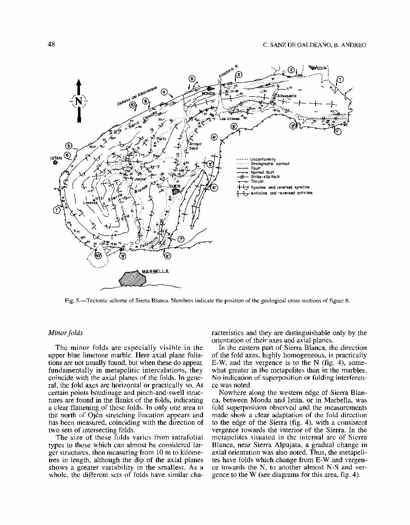
Fig. 5.-Tectonic scheme of Sierra Blanca. Numbers indicate the position of the geological cross sections of figure 6.
Minor folds
The minor folds are especially visible in theupper blue limetone marble. Here axial plane foliations are not usually found, but when these do appear,fundamentally in metapelitic intercalations, theycoincide with the axial planes of the folds. In general, the fold axes are horizontal or practically so. Atcertain points boudinage and pinch-and-swell structures are found in the flanks of the folds, indicatinga clear flattening of these folds. In only one area tothe north of Ojén stretching lineation appears andhas been measured, coinciding with the direction oftwo sets of intersecting folds.
The size of these folds varies from intrafolialtypes to those which can almost be considered larger structures, then measuring from 10m to kilometres in length, although the dip of the axial planesshows a greater variability in the smallest. As awhole, the different sets of folds have similar cha-
racteristics and they are distinguishable only by theorientation of their axes and axial planes.
In the eastern part of Sierra Blanca, the directionof the fold axes, highly homogeneous, is practicallyE-W, and the vergence is to the N (fig. 4), somewhat greater in the metapelites than in the marbles.No indication of superposition or folding interference was noted.
Nowhere along the western edge of Sierra Blanca, between Monda and Istán, or in Marbella, wasfold superposition observed and the measurementsmade show a clear adaptation of the fold directionto the edge of the Sierra (fig. 4), with a consistentvergence towards the interior of the Sierra. In themetapelites situated in the internal arc of SierraBlanca, near Sierra Alpujata, a gradual change inaxial orientation was also noted. Thus, the metapelites have folds which change from E-W and vergence towards the N, to another almost N-S and vergence to the W (see diagrams for this area, fig. 4).

STRUCTURE OF SIERRA BLANCA (BETIC CORDILLERA) 49
Larger structures
The structure of the eastern area of Sierra Blancais relatively simple (fig. 5). The geological sections
of figure 6a show a very tight and complex synclineto the south, verging to the north, oriented E-W onthe extreme east and veering gradually to the NESW towards Arroyo Seco in the west. The northernpart of this area shows a rather tabular structure andthe beginnings of a change of vergence.
In the western area the structure is more complexoThroughout the borders of the area the dips aretowards the exterior of the sierra, that is, the vergence of the structures is towards the interior(fig. 6b and c). The mapping (fig. 5) reveals aninterference of two folds system: one, with generally the largest folds, in approximately a N-S direction, and the other oriented E-W. Both systemsshow different vergences, depending on location.Thus the N-S folds verge westerly in the easternpart of the area and easterly in the western parto TheE-W folds verge northerly and southerly, and repeatthese opposing vergences locally in two successivesets (fig. 6c, cross-sections 9-9' and 10-10').
The interference of these two directions of folding give rise, especially in the central part of thisarea, to a structure roughly resembling an egg cardboard carton, as explained by Ramsay and Huber(1983) for sorne types of superposed folding. Thatis, a series of basins occupied by the upper bluemarble as well as domes, in the nuclei of which thelower white marbles outcrop, and in sorne of themeven the schists, gneisses and migmatites appear (asin El Juanar). Thus, the metapelites outcropping atEl Juanar and farther to the west are from the bottom of the series, as confirmed by the fact that inboth cases these metapelites are lined with lowermarbles (fig. 3), and at certain points the stratigraphic passage between the two types of rock can beobserved.
The northern border of Sierra Blanca is affectedby the Albornoque dextral strike-slip fault (Tubía,1985). Thus, the structures from the northwest ofSierra Blanca show a spectacular stretching, withimbricated structures in various satellite faults,and there are numerous points at which the dextralmovement can be deduced (figs. 3 and 5). Thereare many fish of variable size, from 10 m up to1 km in length, composed of peridotítes, metapelites, marble of different types, and even of Malaguide slate. The continuity between Sierra Blancaand Sierra de Mijas is cut off by the thrust of partof the peridotites of Sierra Alpujata (fig. 2). Thisfact caused the thinning and stretching of themetapelitic formation against the marble at theeastern end of Sierra Blanca.
The western edge of Sierra Blanca is also tectonic, as can be deduced by the fact, among others,that numerous remains of pinched serpentine appearamong the metapelites and marbles of Sierra Blan-
@549E
®
S3W <E>
o"'-....,;,o.~.~...' Km
Cerro Alominoa
Cerro Gordo
®N4W
.ood1
'.1:.-
@N49W
'1 0.'
®N
Within this internal arc, the marbles of the Ojénarea provide clear examples of folding interference.The directions of the folds are from almost N-S inthe Peñoncillo area (north of Marbella) to E-Wsouth of Monda, but in the intermediate zone bothsets of folds interfere on all scales. This interferenceis especíally clear in the interior of Sierra Blanca, inthe Juanar area, where folds prersent similar directíons but in many cases with opposing vergences.Sorne of the diagrams of this area are simple, showing folds of only one of the sets cíted, but generally two or more appear (fig. 4). These features canalso be directly deduced from the larger folds(fig. 5).
Fig. 6.-a) Geological cross-sections of the eastem sector ofSierra Blanca (their position are marked in figs. 3 and 5, and thelegend in fig. 6b). b) E-W geological cross-sections of the westem sector (their positions are marked in figs. 3 and 5). c) N-Sgeological cross-section of the westem sector (their positions are
marked in figs. 3 and 5, and the legend in fig. 6b).

50 C. SANZ DE GALDEANO, B. ANDREO
Arroyo Juanar
S74E®
Mo ' Mologuide
-s.1.
®seOE
N' Neonumidion (Tertiory Flysch)
Borroneo dePuerto Rico
¡
Llanos Juonor
de Morbello1215m
Sierra Blanco
Cerro Zarina _..__~-....1141 m / ' ... ,
/
®
Fig.6b.
®NI2E
Arroyo Seco
1Llanos de Purla
Sierra Conucho
Sierra Canucho
Llanos del\.:i-- - -t ........ Juanar Puerto de",-" ---- --------t Morbello
''' .....~~'I.'............... ---- '- ...
Sierro Blanco
o 0.5.
""<:,s ... - _'.,-"' .........
Rood
®SIOW
@SI7W
\~
Fig.6c.

STRUCTURE OF SIERRA BLANCA (BETIC CORDILLERA) 51
-N
---N
ú V
o .OEO
71 .~ .
O[Q] E V
_N
\-1'
$_
o Morbles
~Mic;lmotites
~ gneisses a .chist.
w~---
O···O·····@] E D
Fig. 7.-Schemes showing the model of the structural formation of Sierra Blanca. a) First displacement towards the N7üE of theLos Reales unit, with peridotites at the base, oyer the Blanca unit as yet unstructured. b) Separation of the Sierras Blanca andMijas as two subunits. c) Continuation of the structuring process of the Sierras Blanca and Mijas, also indicating the appearance ofthe antiform and synform structures in the peridotites in the area of Sierra Alpujata. d) Structure of the Sierras Blanca and Mijasbefore the actiyity of the Albornoque fault. The large arrows indicate the direction of displacement of the whole of the Internal
Zones (westerly) and the small arrows the gradual increasing opposition offered against the adyance.
ca, whether lower or upper. The extreme south ofSierra Blanca is affected by a fault in an E-W direction, showing a normal, fundamentally verticalmovement of over a 1,000 m, with a fault-plane surface of 70-80° S. On this edge, sorne intercalatedserpentine fish are also found.
The eastern and southeastern edges of SierraBlanca appear to be general1y in gradual stratigraphic transition, although reversed, between the gneisses and schists with the lower marble. Over thegneisses lie migmatites, and finally the overthrusting peridotites (figs. 3 and 5).
Genesis oC the structure
The structure of Sierra Blanca can be explainedwith a model similar to that proposed by Frizon de
Lamotte et al. (1991) for different sectors of theBetic Cordillera and that suggested by Andreo &Sanz de Galdeano (1994) to explain the structure ofSierra de Mijas. According to this model, during themovement of a unit, lateral folds are formed whichcould present opposing vergences and frontal deformations appear.
To apply this model to the Blanca unit, we consider a general displacement towards the W of theInternal Zones of the Betic Cordillera in relationwith the External Zones. Thus, the Los Reales andthe Blanca units moved jointly towards the W within this displacement, with the Los Reales unit tectonically superposed, or partially superposed, to theBlanca unit. Our reconstruction of figure 7 begins atthe moment when the Los Reales unit, situated in ahigher position, was partially obstructed in its westwards displacement (by the Malaguide Complex or

52
even by the most internal units of External Zones?)and began to move eastward (in a N70E sense according Tubía and Cuevas, 1987) in relation to the Blanca unit, which continued moving westwards (fig. 7a).During this displacement, under ductile deforrnationconditions, the Blanca unit began to be partially stopped, as happened previously to the Los Rosales unit,and its western extreme, which currently constitutesits principal nucleus, rotated anti-clockwise owing tothe impossibility of an easy westward advance. Atthe same time, part of the unit broke off and individualized, constituting the present-day Sierra deMijas, whose western edge presents curved folds forming the front of a new unit or subunit within theBlanca unit (fig. 7b and c).
The rotation of the nucleus of Sierra Blanca caused the old folds of approximately E-W directionveer to a N-S direction, and the coexisting westerlymovement pressed the fo1ds even more. In the lastphases of the rotation, new E-W folds formed, causing the interference described aboye in Section 3(fig.7d).
Tubía (1985) believed that the arching of thestructures occurred in a clockwise direction, causedby the dextral movement of the Albornoque fault;that is, the arcuated form of Sierra Blanca would belinked to the deformations occurring after the internal structuring of the unit. It is certain that, as indicated aboye, the Albornoque fault arches and greatly stretches the structures in the northwestern partof Sierra Blanca, but in our opinion this effect issuperimposed on the structuring process describedhere, because this fault does not explain the interference of folding and in many places cuts previousstructures.
Owing to the displacement of the Betic-Rif Internal Zones towards the W the Gibraltar Arc was formed, well drawn by the units of the Campo deGibraltar (fig. 1) and by the External Zones there,whereas the Internal Zones adapted less to this arc,the most important exception being Sierra Blanca.
We have refered to the hypotheses of Doblas andOyarzun (1989a and b) and Platt and Vissers (1989)explaining the formation of the Gibraltar Arc andthe Alboran Sea by an extensional collapse. Nevertheless, according to the general structure of the Sierra Blanca unit and the Los Reales unit, and manyother data especially from the Internal-Externalcontact of the Betic and Rif cordilleras, we preferthe present model of the westward displacement ofthe Internal Zones, admitting at the same time anextensional process that opened the Alboran sea atthe back of the displacing Internal Zones, an opening process that was the continuation of the extension produced coetaneously in the Algerine basin(Sanz de Galdeano, 1990).
C. SANZ DE GALDEANO, B. ANDREO
Chronology
The principal features of the structures describedappear to have formed before the end of the Aquitanian, given that transgressive formations from thisage and from the Early Burdigalian fossilized thecontacts between the Malaguide and AlpujarrideComplexes in this region, later thant the structuringof the units (Bourgois, 1978; Martín-Algarra, 1987;Sanz de Galdeano et al., 1993). Sorne of these formations contain boulders of peridotites and migmatites, like the Las Millanas forrnation dated as EarlyBurdigalian (approximately 20 m.a. ago) by Bourgois et al. (1972). On the other hand, Monié et al.(1991) and Jabaloy et al. (1993) propose on age of25 m.a. for the end of the HP/LT event affecting theAlpujarride nappes, that is, at the end of the Oligocene or beginning of the Aquitanian, depending onthe chronostratigraphic scale used. These data suggest that the present structure of Sierra Blanca wasformed at the end of the Oligocene-Aquitanian,coinciding approximately with the beginning of thecited westwards displacement of the Betic and RifInternal Zones.
The Albornoque fault must have begun its movement at the point when ductile deformations changed to fragile, which, in the first stages caused theimportant stretching of the northwest of SierraBlanca. This activity possibly began in the MiddleAquitanian and probably did not continue after theBurdigalian, or at most until the Middle Miocene.Its displacements also contribute to the westwardmovement of the Internal Zone.
The fault of the South of Sierra Blanca is posterior to the rest of the structures described, althoughits age is not possible to indicate with precision; itwas probably formed during the Late Miocene.
Tectonic position of the peridotites
Tangential to the objective of this work, this section has been included because of the role played bythe peridotites in the structuring of Sierra Blanca,which they overlie. On the E-SE edge of SierraBlanca, the succession of marbles, schists, gneissesand mignatites are found inverted, with the peridotites of Sierra Alpujata on top, although separated bya tectonic contact. This seems to suggest that if theinversion were undone, the peridotites would besituated under the Blanca unit. However, the geometry of the whole peridotite outcrops, both to theE in the Sierra Alpujata and to the west in Los Reales, clearly shows that the peridotites are situatedover the Blanca unit as was previously indicated byLundeen and Obata (1977), Tubía (1985) and Tubía
STRUCTURE OF SIERRA BLANCA (BETIC CORDILLERA) 53
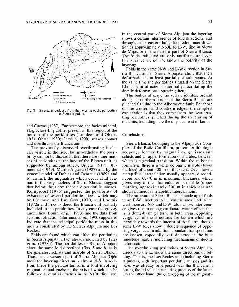
Fig. 8.-Structures deduced fram the layering of the peridotitesin Sierra Alpujata.
and Cuevas (1987). Furthermore, the facies mineral,Plagioclase-Lh~rzolite, present in this region at thebottom of the peridotites (Lundeen and Obata,1977; Obata, 1980; Gervilla, 1990), makes contactand overthrusts the Blanca unit.
The previously discussed overthrusting is clearIy visible in the field, but nevertheless the possibility cannot be discarded that there are other masses of peridotites at the base of the Blanca unit, assuggested by, among others, Orueta (1917), Blumenthal (1949), Martín-Algarra (1987) and by thegeneral model of Doblas and Oyarzun (1989a andb). In fact, the migmatites which occur at El Juanar, in the very nucleus of Sierra Blanca, suggestthat below the sierra there are peridotitic masses.Kornprobst (1976) suggested the possibility ofexistence of several peridotitic slices, which maybe the case, and Buntfuss (1970) and Loomis(1972a and b) considered the Blanca unit partiallyincluded in the peridotites. In any case the gravityanomalies (Bonini et al., 1973) and the data fromseismic refraction (Barranco et al., 1990) appear toindicate that the principal peridotite mass in thisarea is constituted by the Sierras Alpujata and LosReales.
Folds are found which can affect the peridotitesin Sierra Alpujata, a fact already indicated by Pileset al. (1978b). The peridotites of Sierra Alpujatashow the same fold directions (figs. 5 and 8) as inthe gneisses, schists and marble of Sierra Blanca.Thus, in the western part of Sierra Alpujata (Ojénarea) the layering direction is almost N-S. In addition, there the peridotites form a fold involvingmigmatites and gneisses, the axis of which can befollowed several kilometres in the NIOE direction.
- fault
T""T""'T'" Normal foult
....--.- Thrust
- Intrusive canteet
+-+ 5ynform
+-t Antiform
_._.- Layering in t he peridotites
In the central part of Sierra Alpujata the layeringshows a certain interference of fold directions, andthroughout its eastern half, the predominant direction is approximately N60E to E-W, like in Sierrade Mijas or in the eastern part of Sierra Blanca.The folds indicated are only antiforms and synforms, since we do not know the polarity of thelayering.
Folds in the same N-W and E-W direction in Sierra Blanca and in Sierra Alpujata, show that theirdeformation is at least partially simultaneous. Atthe same time the peridotites situated on the SierraBlanca unit affected it thermally, facilitating theductile deformations appearing there.
The bodies of serpentinized peridotites, presentalong the northern border of the Sierra Blanca arepinched fish due to the Albornoque fault. For thoseon the western and southern edges, the simplestexplanation is that they come from the overthrusting peridotites, pinched during the structuring ofthe units, including here the displacement of faults.
Conclusions
Sierra Blanca, belonging to the Alpujarride Complex of the Betic Cordillera, presents a lithologicsequence formed by migmatites, gneis ses andschists and an upper formation of marbles, betweenwhich is a gradual transition. Within the carbonateformation, there is a white dolomitic marble (lowermarbles) of about 300 m in thickness. Over these ametapelitic intercalation usually appears, discontinuous and 60-70 m in maximum thickness, whichgives way to the blue calcareous marble (uppermarbles) approximately 300 m in thickness andshows numerous metapelitic intercalations.
The structure of Sierra Blanca is made up of foldsin an E-W direction in the eastern area, and in thewest there are N-S and E-W folds whose interference gives rise to an egg cardboard carton effect, thatis, a dome-basin pattern. In both areas, opposingvergences of the structures are known which areinvariably towards the interior of the Sierra, thoughsorne E-W folds show a double sequence of opposing vergences. In addition, abundant transpositionsare known, especially well detected in the bluelimestone marble, indicating mechanisms of ductiledeformation.
The overthrusting peridotites of Sierra Alpujata,directIy to the E, show the same directions of folding. That is, the Los Reales unit (including SierraAlpujata), with important peridotite masses and itsbase, was already superposed over the Blanca unitduring the principal structuring process of the latter.On the other hand, the outcropping of the migmati-

54
tes of El Juanar raise suspicions that under SierraBlanca there are also peridotite masses.
A model involving westward movements and forming frontal and lateral folds would explain thisstructure of Sierra Blanca. During its westwardadvance, the most westerly part of Sierra Blancaappears to have rotated anti-clockwise, practically90° and then formed the folding interference.
These structures may have formed at the end ofthe Oligocene-Aquitanian inserted in the westwarddisplacements of the Betic-Rif Internal Zones fromtheir original position, approximately the south ofSardinia, towards the present situation within theBetic and Rif Cordilleras. It is precisely SierraBlanca, within the units of the Internal Betic Zones,which shows a better adaptation to the form of theGibraltar arc.
ACKNOWLEDGEMENTS
We wish to thank Dr. M. Doblas (Madrid) and Dr. R.Trümpy (Zürich) for their helpful suggestions and criticisms.This work has been financed by Projects PB9110079 andPB90/0818 of the DGICYT and the Research Groups 4085 and4021 of the Junta de Andalucía
References
Andreo, B. & Sanz de Galdeano, C. (1994). Structure ofthe Sierra de Mijas (Alpujarride Complex, Betic Cordillera). Annales Tectonicae, Firenze, 8, 23-35.
Andrieux, J., Fontboté, J. M. & Mattauer, M. (1971). Surun modele explicatif de l'Arc de Gibraltar. Bull. SocoCéo!. France, 7 (15-2), 115-118.
Balanyá Roure, J. C. (1991). Estructura del dominio deAlbarán en la parte norte del Arco de Cibraltar. Thesis Univ., Granada, 233 p.
Barranco, L. M.; Ansorge, l & Banda, E. (1990). Seismic refraction constraints on the geometry of theRonda peridotitic massif (Betic Cordillera, Spain).Tectonophysics, 184,379-392.
Biot, J. P. (1971). Sur les marbres métamorphiques et lasérie gneissique du flanc méridional de la Sierra deMijas (Prov. de Málaga, Espagne). C. R. Acad. Sc.Paris, 272,2128-2130.
Blumenthal, M. (1930). Beitrage zur Geologie der betischen Cordilleren beiderseits des Rio Guadalhorce.Eclogae Ceo!. Helvetiae, 23,41-293.
Blumenthal, M. (1949). Estudio geológico de las cadenascosteras al oeste de Málaga entre el río Guadalhorce yel río Verde. Bol. Ceo!. Min., 62, 11-203.
Bonini, W. E., Loomis, T. P. & Robertson, J. D. (1973).Gravity anomalies, ultramafic intrusions and the tectonics of the region around the Strait of Gibraltar. l.Ceophys. Res., 78, 1372-1382.
Bourgois, J. (1978). La transversale de Ronda. Cordilleres Bétiques, Espagne. Donnés géologiques pour unmodele d'évolution de l'Arc de Cibraltar. ThesisUniv., Besan<;on, 3e série, 30,445 p.
C. SANZ DE GALDEANO, B. ANDREO
Bourgois, l, Chauve, l, Magné, l, Monnot, Y, Peyre,Y., Rigo, E. & Riviere, M. (1972). La formation deLas Millanas. Série burdigalienne transgressive sur leszones internes des Cordilleres Bétiques occidentales(région de Alozaina-Tolox, province de Málaga,Espagne). C. R. Acad. Sc. Paris, 275, 1969-1972.
Buntfuss, J. (1970). Die Geologie der Küstenketten swischen dem Río Guadalhorce und dem Campo de Gibraltar. Ceo!. lb., 88, 373-420.
Copponex, J. P. (1959). Observations geologiques sur lesAlpujarrides occidentales. Bo!. Ceo!. Min., 70, 79-208.
Delgado, F., Estévez, A., Martín, J.M. & Martín-Algarra,A. (1981). Observaciones sobre la estratigrafía de laformación carbonatada de los mantos alpujárrides(Cordilleras Béticas). Estudios Ceo!., 37,45-57.
Doblas, M. & Oyarzun, R. (1989a). Neogene extensionalcollapse in the westem Mediterranean (Betic-Rif Alpineorogenic belt): Implications for the genesis of the Gibraltar Arc and magmatic activity. Ceology, 17,430-433.
Doblas, M. & Oyarzun, R. (1989b). «Mantle core complexes» and Neogene extensional detachment tectonicsin the western Betic Cordilleras, Spain: An alternativemodel for the emplacement of the Ronda peridotite.Earth Planet. Sci. Letters, 93, 76-84.
Durand-Delga, M. & Fontboté, J. M. (1980). Le cadrestructural de la Méditerranée occidentale. 26 Congres.Céol. Intern., Paris. Les Chaínes alpines issues de laTéthys. Mém. B.R.C.M., 115,67-85.
Estévez, A., Delgado, F., Sanz de Galdeano, C. & Martín-Algarra, A. (1985). Los Alpujárrides al Sur de Sierra Nevada. Una revisión de su estructura. Mediterránea, 4, 5-32.
Frizon de Lamotte, D., Andrieux, J. & Guezou, J. C.(1991). Cinématique des chevauchements néogenesdans l' Arc bético-rifain: Discussion sur les modelesgéodynamiques. Bull. Soco Céol. France, 162,4,611626.
Gervilla, F. (1990). Mineralizaciones magmáticas ligadas a la evolución de las rocas ultramáficas de laSerranía de Ronda (Málaga-España). Thesis Univ.,Granada, 189 p.
Hoeppener, R., Hoppe, P., Dürr, S. T. & Mollat, H.(1964). Ein querschnitt durch die Betischen Kordilleren bei Ronda (SW Spanien). Ceol. en Mijnbouw, 43,282-298.
Jabaloy, A.; Galindo-Zaldívar, J. & González Lodeiro, F.(1993). The Alpujárride-Nevado-Filábride extensionalshear zone, Betic Cordillera, SE Spain. l. Struct. Ceo!.,15,555-569.
Junta de Andalucía (1985). Mapa geológico y minero deAndalucía. Dirección General de Industria, Energía yMinas, 150 p.
Kornprobst, J. (1976). Signification structurale des péridotites dans l' orogene bético-rifain: Arguments tirés del' étude des détritus observés dans les sédiments paléozolques. Bull. Soco Céo!. France, 18 (3), 607-618.
Loomis, T. P. (1972a). Contact metamorphism of PeliticRock by the Ronda ultramafic intrusion, SouthernSpain. Ceol. Soco Amer. Bull., 83, 2449-2474.
Loomis, T. P. (1972b). Diapiric emplacement of theRonda high-temperature ultramafic intrusion, SouthernSpain. Ceol. Soco Amer. Bull., 83,2475-2496.
Loomis, T. P. (1975). Tertiary mantle diapirism, orogeny, and plate tectonics east of the Strait of Gibraltar.Amer. l. Sci., 275, 1-30.
STRUCTURE OF SIERRA BLANCA (BETIC CORDILLERA)
Lundeen, M. T. (1978). Emplacement of the Ronda peridotite, Sierra Bermeja, Spain. Geol. Soco Amer. Bull.,89,172-180.
Lundeen, M. T. & Obata, M. (1977). Geo1ogic Map ofthe Ronda u1tramaphic complex, Southern Spain. Geol.SOCo America.
Martín-A1garra, A. (1987). Evolución geológica alpinadel contacto entre las Zonas Internas y las ZonasExternas de la Cordillera Bética (Sector Occidental).Thesis Univ., Granada, 1,171 p.
Mollat, H. (1968). Schicthenfo1ge und tecktonischer Bander Sierra Blanca und ihrer Umgebung. Geol. lb., 86,471-532.
Monié, P., Galindo-Zaldívar, J., González Lodeiro, F.,Goffé, B. & Jabaloy, A. (1991). 40 Ar/39 Ar geochronology of alpine tectonism in the Betic Cordilleras(Southern Spain). l. Geol. Soco London, 148,289-297.
Obata, M. (1980). The Ronda peridotites Garnet-Spineland P1agioclasa-Lherzolite facies and the P-T trajectories of a high-temperature mande intrusion. l. Petrology, 21,533-572.
Orueta, D. (1917). Estudio geológico y petrográfico de laSerranía de Ronda. Láminas, mapas y cortes geológicos. Memorias del Instituto Geológico de España,571 p.
Piles, E., Chamón, C. & Estévez-González, C. (1978a).Mapa y memoria explicativa de la hoja 1065 (Marbella) del Mapa Geológico Nacional a escala 1:50.000.ITGE.
Piles, E., Chamón, C. & Estévez-Gonzá1ez, C. (1978b).Mapa y memoria explicativa de la hoja 1066 (Coín)del Mapa Geológico Nacional a escala 1:50.000.ITGE.
Platt, 1. P. & Visser, R. L. M. (1989). Extensional collapse of thickened continental lithosphere: A workinghypothesis for the Alboran Sea and Gibraltar are. Geology, 17,540-543.
Ramsay,1. G. & Huber, M. 1. (1983). The Techniques ofModern Structural Geology. Strain Analysis and Foldsand Fractures. Academic Press, London, 504 p.
Salobreña, C. (1977). Geología del sector Ojén-Monda
55
(Prov. de Málaga), Cordilleras Béticas (España).Tesis de licenciatura, Univ. Granada (unpublished),85 p.
Sanz de Galdeano, C. (1990). Geologic evolution of theBetic Cordilleras in the Western Mediterranean, Miocene to the presento Tectonophysics, 172, 107-119.
Sanz de Ga1deano, c.; Serrano, F., López-Garrido, A. C.& Martín-Pérez, J. A. (1993). Pa1aeogeography of theLate Aquitanian-Ear1y Burdigalian Basin in the western Betic Internal Zone. Geobios, 26, 1,43-55.
Torres Ro1dán, R. (1979). The tectonic subdivion of theBetic Zone (Betic Cordilleras, Southern Spain): Its significance and one possib1e geotectonic scenario for theWesternmost A1pine Be1t. Amer. l. Sci., 279, 19-51.
Tubía, J. M. (1985). Estructura de los A1pujárrides occidentales: Cinemática y condiciones de emplazamientode las peridotitas de Ronda. Bol. Geol. Min., 99.
Tubía, J. M. & Cuevas, 1. (1987). Structures et cinématique liées a la mise en place des péridotites de Ronda(Cordilleres Bétiques, Espagne). Geodinamica Acta, 1,1,59-69.
Tubía, J. M. & Gil Ibarguchi, J. 1. (1991). Eclogites ofthe Ojén nappe: A record of subduction in the Alpujarride comp1ex (Betic Cordilleras, southern Spain). l.Geol. Soco London, 148,801-804.
Tubía, J. M., Navarro-Vi1a, F. & Cuevas, J. (1993). TheMa1águide-Los Reales Nappe: An examp1e of crusta1thinning re1ated ot the emplacement of the Ronda peridotites (Betic Cordillera). Physics Earth Planet. Interiors, 78, 343-354.
Westerhof, A. E. (1983). Genesis of magnetite ore nearMarbella, Southern Spain: Formation by oxidation ofsilicates in polimetamorphic gedrite-bearing and otherrocks. Gua Papers ofGeology, 1,216 p.
Wildi, W. (1983). La Chaine tello-rifaine (Algérie,Maroc, Tunisie): Structure, stratigraphie et évo1utiondu Trias au Miocene. Rev. Géol. Dyn. et Géogr. Phys.,24,201-297.
Recibido el16 de septiembre de 1994Aceptado ellO de marzo de 1995