Embed Size (px)
Citation preview

050 051
The Instability of Terrain
Stuart Elden on Limits and Boundaries
A boundary is, at its most straightforward, a line that divides. Today we think of a boundary as a line that divides two places, often states. This line can be drawn in different ways — made visible on the landscape through fences, walls, or ditches, or simply by cutting through forest or brush. It might be invisible to a person on the ground but enforced by a clause in a treaty or other legal agreement. Politics, people, and materials cross such lines all the time, whether with ease or friction. A boundary is, in this definition, a line of nominally zero width.

PENNSYLVANIA
MD
DEWESTVIRGINIA
VIRGINIA
Mason-Dixon Line
052 Stuart Elden The Instability of Terrain053
the general distribution of spaces is agreed on or imposed. The border might be at the vague edge of a forest, a mountain range, a river; or it might be lines of control sketched on a map at some distance from the actual landscape. The second stage is delimitation, which requires more attention to detail and a
more accurate survey of the landscape. At this stage, geographical coordinates need to be agreed on and either listed in great detail or represented through a map. Third is demarcation, where the physical landscape is marked with boundary stones, where fences or walls are built, or vistas cleared. While particularities on the ground may change the course of the line — given “local needs and the realities of the terrain” — Jones’s guidelines stress that delimitation and demarcation are successive, that the materialization of a line on the ground is subsequent to its definition in legal and political agreements.5
The techniques required for delimitation and demarcation have evolved over time with developments in cartography and land-surveying — themselves made possible by the development of coordinates and analytic geometry and the accurate measurement of distance and time. Choosing the forty-ninth parallel for the western part of the boundary between the United States and Canada was one thing, but turning it into a visible line on the ground was another, taking many years and huge amounts of labor and expense. At least part of the reason was that the line of the parallel, seemingly so elegant on the abstraction of a map, did not take into account the rivers, lakes, and mountains over which it ran. The United States was no stranger to this sort of problem, with the Mason-Dixon line, which took several years to survey.A It required unprecedented
In this way, it is distinct from a frontier, which, as a region or zone of transition, has width. Historically these terms were less precise, and there is still confusion around them. Some political geographers insist that we sharply distinguish between boundaries and frontiers, two distinct species within the wider genus of border.1 Other scholars use the terms in a different way, not always consistently: the discipline of border studies, for example, often discusses what others would more narrowly specify as boundaries.2 But the terms become even more complicated when we move between languages. Though today the French term frontière, the Italian confine, and the German Grenze tend to be similar to the English boundary, there are of course other terms in these languages that complicate the concept, often implying width rather than a line — limite, frontiera, Rand, and so on.
In Livy’s account of the history of Rome, Romulus and Remus quarreled because Remus jumped over the line Romulus had drawn to mark the walls of his new city.3 Caesar’s crossing of the Rubicon triggered the civil war with Pompey — the river marked the limit of his imperium in Cisalpine Gaul, and he should have crossed it as a civilian not as a military commander. Classical authors likened the Alps to a defensive wall for Rome, but not a limit to its expansion.
The classical Romans attached importance to borders at various spatial scales and often marked or fortified them. While the word territorium is exceptionally rare in classical Latin — and does not straightforwardly translate into the modern territory — Latin has various boundary words, including fines, terminus, rigor, and limes. The term limes is particularly interesting. Limes, as described by Livy, was initially a path or byway; it could be a supply line for the army or a route between places, and it was therefore an element that connected rather than divided. A new sense of the term was later reflected by Tacitus as including the fortifications alongside this line. In time, it came to mean something closer to a modern understanding of frontier, an area Rome was fighting over with others. The limes was no longer simply a line but a zone. The frontier system of the Roman Empire, of which Hadrian’s eponymous wall is the obvious example (even if it was never explicitly called a limes), was something that really only came to pass in the second century. Yet even at this point, we are still some distance away from boundaries in the modern sense, and certainly from a homogeneous territory enclosed by them.4
Stephen B. Jones’s Boundary Making: A Handbook for Statesmen, Treaty Editors, and Boundary Commissioners was published in 1945 and was intended to serve as a guide to new boundaries in the postwar world. Jones suggests there are four stages to boundary making. The first is allocation, in which
1. See, for example, Jean Gottmann, The Significance of Territory (Charlottesville: University Press of Virginia, 1973), 134, and J. R. V. Prescott, Political Geography (London: Methuen, 1972), 54. 2. See, for example, Nick Vaughan-Williams, Border Politics: The Limits of Sovereign Power (Edinburgh: Edinburgh University Press, 2009). For a discussion of this, see Henk van Houtum, “The Geopolitics of Borders and Boundaries,” Geopolitics 10, no. 4 (October 2005): 672–679.
3. Livy, Ab urbe condita, trans. B. O. Foster, Frank Gardner Moore, Evan T. Sage, and Alfred C. Schlesinger, 14 vols. (London: William Heinemann, 1919–1959), 1:6–7. 4. See the discussion in Stuart Elden, The Birth of Territory (Chicago: University of Chicago Press, 2013), chap. 2 and the references there, notably Benjamin Isaac, “The Meaning of the Terms Limes and Limitanei,” Journal of Roman Studies 78 (November 1988): 125–147; see also Christopher Smith,
“Ager Romanus antiquus,” Archeologia Classica 68, no. 2017 (November 2017): 1–26. 5. Stephen B. Jones, Boundary Making: A Handbook for Statesmen, Treaty Editors, and Boundary Commissioners (Washington DC: Carnegie Endowment for International Peace, 1945), 165. See John W. Donaldson and Alison J. Williams, “Delimitation and Demarcation: Analysing the Legacy of Stephen B. Jones’s Boundary-Making,” Geopolitics 13, no. 4 (2008): 675–700.
PAGE 050
A boundary mark being positioned on top of an anthill during the demarcation of the border between Northern Rhodesia (which was a British protectorate) and the Belgian Congo. The photograph was shot in 1913 by E.R.L. Peake, an army surveyor leading the British delegation. The line has become the border between DR Congo and Zambia.
A THE MASON- DIXON LINE
Portion of the state boundary surveyed between 1763 and 1767 by Charles Mason and Jeremiah Dixon, to settle a feud between the rulers of Maryland and Pennsylvania
0 100 km
WestJerusalem
EastJerusalem
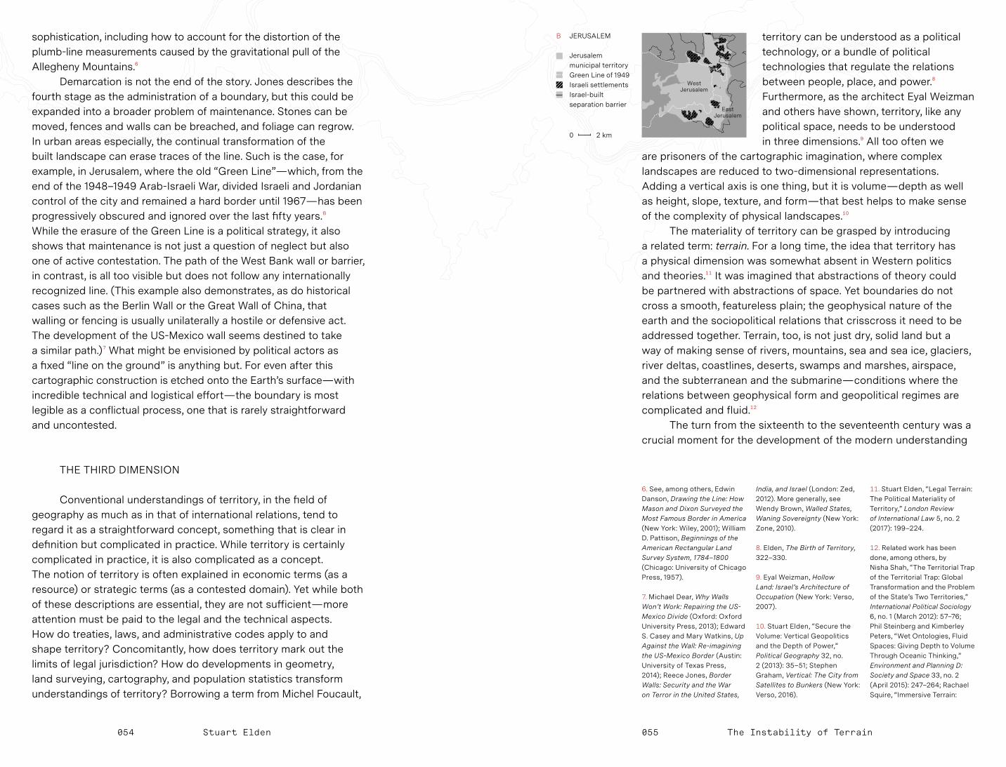
054 Stuart Elden The Instability of Terrain055
territory can be understood as a political technology, or a bundle of political technologies that regulate the relations between people, place, and power.8 Furthermore, as the architect Eyal Weizman and others have shown, territory, like any political space, needs to be understood in three dimensions.9 All too often we
are prisoners of the cartographic imagination, where complex landscapes are reduced to two-dimensional representations. Adding a vertical axis is one thing, but it is volume — depth as well as height, slope, texture, and form — that best helps to make sense of the complexity of physical landscapes.10
The materiality of territory can be grasped by introducing a related term: terrain. For a long time, the idea that territory has a physical dimension was somewhat absent in Western politics and theories.11 It was imagined that abstractions of theory could be partnered with abstractions of space. Yet boundaries do not cross a smooth, featureless plain; the geophysical nature of the earth and the sociopolitical relations that crisscross it need to be addressed together. Terrain, too, is not just dry, solid land but a way of making sense of rivers, mountains, sea and sea ice, glaciers, river deltas, coastlines, deserts, swamps and marshes, airspace, and the subterranean and the submarine — conditions where the relations between geophysical form and geopolitical regimes are complicated and fluid.12
The turn from the sixteenth to the seventeenth century was a crucial moment for the development of the modern understanding
sophistication, including how to account for the distortion of the plumb-line measurements caused by the gravitational pull of the Allegheny Mountains.6
Demarcation is not the end of the story. Jones describes the fourth stage as the administration of a boundary, but this could be expanded into a broader problem of maintenance. Stones can be moved, fences and walls can be breached, and foliage can regrow. In urban areas especially, the continual transformation of the built landscape can erase traces of the line. Such is the case, for example, in Jerusalem, where the old “Green Line” — which, from the end of the 1948–1949 Arab-Israeli War, divided Israeli and Jordanian control of the city and remained a hard border until 1967 — has been progressively obscured and ignored over the last fifty years.B While the erasure of the Green Line is a political strategy, it also shows that maintenance is not just a question of neglect but also one of active contestation. The path of the West Bank wall or barrier, in contrast, is all too visible but does not follow any internationally recognized line. (This example also demonstrates, as do historical cases such as the Berlin Wall or the Great Wall of China, that walling or fencing is usually unilaterally a hostile or defensive act. The development of the US-Mexico wall seems destined to take a similar path.) 7 What might be envisioned by political actors as a fixed “line on the ground” is anything but. For even after this cartographic construction is etched onto the Earth’s surface — with incredible technical and logistical effort — the boundary is most legible as a conflictual process, one that is rarely straightforward and uncontested.
THE THIRD DIMENSION
Conventional understandings of territory, in the field of geography as much as in that of international relations, tend to regard it as a straightforward concept, something that is clear in definition but complicated in practice. While territory is certainly complicated in practice, it is also complicated as a concept. The notion of territory is often explained in economic terms (as a resource) or strategic terms (as a contested domain). Yet while both of these descriptions are essential, they are not sufficient — more attention must be paid to the legal and the technical aspects. How do treaties, laws, and administrative codes apply to and shape territory? Concomitantly, how does territory mark out the limits of legal jurisdiction? How do developments in geometry, land surveying, cartography, and population statistics transform understandings of territory? Borrowing a term from Michel Foucault,
6. See, among others, Edwin Danson, Drawing the Line: How Mason and Dixon Surveyed the Most Famous Border in America (New York: Wiley, 2001); William D. Pattison, Beginnings of the American Rectangular Land Survey System, 1784–1800 (Chicago: University of Chicago Press, 1957). 7. Michael Dear, Why Walls Won’t Work: Repairing the US-Mexico Divide (Oxford: Oxford University Press, 2013); Edward S. Casey and Mary Watkins, Up Against the Wall: Re-imagining the US-Mexico Border (Austin: University of Texas Press, 2014); Reece Jones, Border Walls: Security and the War on Terror in the United States,
India, and Israel (London: Zed, 2012). More generally, see Wendy Brown, Walled States, Waning Sovereignty (New York: Zone, 2010). 8. Elden, The Birth of Territory, 322–330. 9. Eyal Weizman, Hollow Land: Israel’s Architecture of Occupation (New York: Verso, 2007). 10. Stuart Elden, “Secure the Volume: Vertical Geopolitics and the Depth of Power,” Political Geography 32, no. 2 (2013): 35–51; Stephen Graham, Vertical: The City from Satellites to Bunkers (New York: Verso, 2016).
11. Stuart Elden, “Legal Terrain: The Political Materiality of Territory,” London Review of International Law 5, no. 2 (2017): 199–224. 12. Related work has been done, among others, by Nisha Shah, “The Territorial Trap of the Territorial Trap: Global Transformation and the Problem of the State’s Two Territories,” International Political Sociology 6, no. 1 (March 2012): 57–76; Phil Steinberg and Kimberley Peters, “Wet Ontologies, Fluid Spaces: Giving Depth to Volume Through Oceanic Thinking,” Environment and Planning D: Society and Space 33, no. 2 (April 2015): 247–264; Rachael Squire, “Immersive Terrain:
0 2 km
B JERUSALEM
Jerusalem municipal territory Green Line of 1949 Israeli settlements Israel-built separation barrier

DR CONGO
ZAMBIA
CongoRiver
watershed
LuapulaRiver
056 Stuart Elden The Instability of Terrain057
Natural features designated as boundaries, a watershed for instance, were often thought to require no effective demarcation, since the ridge of a mountain chain is in theory legible enough. Nonetheless, at times, it has become significant to mark boundaries on the ground. Take for example the
second Anglo-Belgian commission tasked, between 1927 and 1933, with the demarcation of the Belgian Congo-Northern Rhodesia boundary.C While the line had previously followed the Congo-Zambezi watershed with few markers, the commission was created to turn that legal-geophysical decision into a clearer material line etched onto the landscape.18
The distinction between “natural” boundaries (coastlines, deserts, mountains, and rivers) and artificial ones (parallels and meridians) has many historical lineages. In the seventeenth century, Cardinal Richelieu proposed that France had natural limits — its coastline from the English Channel to the Atlantic, the Pyrenees, the Mediterranean Sea, the Alps, the Rhine — up to which the country should expand but not go beyond.19 This provided a shape for France: the well-known hexagon. Richelieu’s conception raises as many questions as it settles. What about offshore islands? How do you chart a path through a mountain range? Where in the river does the boundary lie? Why this river and not that one? Equally, what happens in areas where geophysical features are less clear?
of territory based on national sovereignty. This geopolitical shift can be tracked in the political theory debates at the time between Thomas Hobbes, Samuel Pufendorf, and Gottfried Wilhelm Leibniz, but it also can be seen in literary work. While Shakespeare rarely uses the word territory or territories, many of his plays deal with issues of conquest, succession, exile, banishment, and property and inheritance. Through a close reading of Shakespeare we can thus understand how territory is not simply a bounded space, as it is generally considered; rather, it encompasses a wide variety of different, contested processes.13 Territory is not a product; it is continually made and remade — by bordering, dividing, conquering, excluding, enclosing, controlling, surveying, mapping.
THE MYTH OF NATURAL BOUNDARIES
We often think that territory is defined by boundaries — that it is a consequence of the boundaries that surround it. This situation may well be true today, but in terms of historical development things happened in reverse. It is the notion of territory — as a political counterpart to the geometrical, calculative space that emerged in the scientific revolution — that makes modern boundaries possible. The technological advancements that enabled large-scale land surveying and accurate cartography in the sixteenth century meant that lines could be drawn and limits could be indicated with a new degree of precision.14 States were crucial to these technological advancements: their wishes for clear and fortified boundaries often led to commissions or rewards for the development of new cartographic, surveying, and measuring methods. While in premodern times an entire river might have been taken as the border, it slowly became possible to precisely measure the median line or the navigable channel — often described with the German word Thalweg, literally “valley-way.” 15 Likewise, a commission could decide on a precise line through a mountain range, such as one linking peaks or running along a ridgeline or watershed line. Terms thus emerged in tandem with newly delineated boundaries.
It has been said that “the first official boundary in the modern sense” was created by the 1659 Treaty of the Pyrenees.16 Yet the process of translating France and Spain’s territorial aspirations into an actual line on the ground was long and contested. The proposal to use “the summits of the mountains which form the watershed between France and Spain” was incorporated in the Peace of Basel in 1795.17 Debates about what a watershed line was, and where it was located, continued for some time — and only with the Treaties of the Bayonne in 1866–1868 was a line formally delimited and demarcated.
The US Navy, Sealab, and Cold War Undersea Geopolitics,” Area 48, no. 3 (September 2016): 332–338; Gastón Gordillo, “The Metropolis: The Infrastructure of Empire,” in Infrastructures: Environment and Life in the Anthropocene, ed. Kregg Hetherington (Durham, NC: Duke University Press, forthcoming). 13. Stuart Elden, Shakespearean Territories (Chicago: University of Chicago Press, 2018). To pick just one example, in Henry IV, Part I, three opponents to the king are discussing the territorial division they will implement if they defeat him. When one objects to the inequitable divide, he suggests diverting a river rather than drawing a new line on the map to make it fairer.
14. See, for example, Matthew H. Edney, Mapping an Empire: The Geographical Construction of British India, 1765–1843 (Chicago: University of Chicago Press, 1997). 15. Martin Pratt, “The Scholar-Practitioner Interface in Boundary Studies,” Eurasia Border Review 1, no. 1 (Spring 2010): 35. For a detailed study, see John W. Donaldson, “Where Rivers and Boundaries Meet: Building the International River Boundaries Database,” Water Policy 11, no. 5 (October 2009): 629–644.
16. Friedrich Kratochwil, “Of Systems, Boundaries and Territoriality: An Inquiry Into the Formation of the State System,” World Politics 39, no. 1 (October 1986): 33.
17. Treaty of Basel Between the Republic of France and the Kingdom of Spain, July 22, 1795, quoted in Peter Sahlins, Boundaries: The Making of France and Spain in the Pyrenees (Berkeley: University of California Press, 1989), 187–188. 18. For a detailed discussion, see John W. Donaldson, “Marking Territory: Demarcation of the DRC-Zambia Boundary from 1894 to the Present Day” (PhD diss., Durham University, 2010), chap. 5, http://etheses .dur.ac.uk/328. 19. See Peter Sahlins, “Natural Frontiers Revisited: France’s Boundaries Since the Seventeenth Century,” American Historical Review 95, no. 5 (December 1990): 1423–1451.
0 200 km
C DR CONGO- ZAMBIA BOUNDARY
Straight segment drawn in 1884 to settle British and Belgian territorial claims

CAMBODIA
THAILAND
19071907
19621904
Preah Vihear Temple
058 Stuart Elden The Instability of Terrain059
Some of the historically contested areas between France and its neighbors are indeed related to these questions, like Provence east of the Rhône; Savoy on the edge of France and Italy; Alsace-Lorraine west of the Rhine; Flanders and other parts of the lowlands; or the Rhine’s valley and delta.
Today it has been comprehensively demonstrated that all boundaries are constructs, even if they follow natural features, for there is still a great deal of human choice and technique involved.20 Equally, borderlands are often zones of connection and passage. Rivers may be used for transportation, and their management requires significant cooperation; equally, mountain valleys are often inhabited, and passes provide links between two regions. As John Agnew has written: “There is nothing at all ‘natural’ — physically or socially — to borders. They are literally impositions on the world. This is not to say that borders are somehow simply metaphorical or textual, without materiality; lines on a map rather than a set of objects and practices in space. It is more that borders are never transcendental objects that systematically secure spaces in which identities and interests can go unquestioned.” 21 However, denying that borders are natural should not mean that we ignore the way geophysical terrain relates to geopolitical division.22 A boundary line has materiality and materializes legal and political constructs.
In 1904, a boundary between Cambodia and Thailand was proposed that followed a watershed line though the Dângrêk Mountains. The line placed the Temple of Preah Vihear on Thailand’s side, but in 1907 a topographic map of the boundary deviated from the watershed in one region, placing the temple on the Cambodian side instead.D In 1962, the case was taken to the International Court of Justice. It hinged on Thailand’s long acceptance of the map, and the court ruled that the temple did indeed belong to Cambodia.23 This decision, however, did not end the dispute, and conflict flares up periodically. The history of a boundary may be obscured, but past struggles and injustices are embedded in its present.
A DYNAMIC EARTH
Boundaries are frequently conceived as both fixed — in the sense that two states will not seek to change them — and static — in the sense that the line, once determined, will not move. The idea of fixed boundaries is much more recent than is often acknowledged. While the notion of a ruler exercising political power within his or her domain is relatively long- standing, the idea that the limits of that domain are stable is not.
States historically believed they could expand their territory in different ways — through alliance, marriage, purchase, conquest, or punishment. Only with the League of Nations and the Locarno Treaties of 1925 was there an attempt to solidify the post–World War I territorial settlement of Europe.
Subsequent international agreements, including the United Nations Charter, have further stressed territorial integrity, with an emphasis on territorial preservation. Decolonization has largely operated on the basis of uti possidetis, the principle that newly independent states inherit the boundaries of colonial division.24 This concept has helped set the framework for international boundary disputes in the post–World War II era.
Furthermore, the modern notion of boundary — zero-width, visible, unequivocal — is built on assumptions about the geophysical world that do not apply equally everywhere. Not only does it not take into account geographical and historical variation, but it is derived from a model that makes most sense in temperate climates. For example, ice — whether in the sea, as an ice sheet, or in alpine glaciers — can be solid or liquid at different times, requiring different legal-political regimes. With sea ice, does the law of land territory or the law of the sea apply? Similar issues can be found in other environments where the land-water interface is blurred, like coastal swamps, river deltas, and marshlands.25
It is of course obvious to say that the Earth is dynamic. Coastlines change; rivers meander; mountains erode; fertile land becomes desert. Human agency also transforms physical landscapes. Rivers are dammed, canals cut, roads or railways built. Urbanization might lead to land reclamation, to rivers being built over, to the movement of sediment or land. However, because of climate change caused by anthropogenic emissions, these processes are occurring at a much faster rate than any recorded in human history. Coastlines are rapidly changing;
20. See, for example, Juliet Fall, “Artificial States? On the Enduring Geographical Myth of Natural Borders,” Political Geography 29, no. 3 (March 2010): 140–147.
21. John Agnew, “Borders on the Mind: Re-framing Border Thinking,” Ethics and Global Politics 1, no. 4 (2008): 181.
22. Van Houtum makes similar points in “Geopolitics of Borders and Boundaries,” esp. 675–676. 23. International Court of Justice, “Case Concerning the Temple of Preah Vihear (Cambodia v. Thailand), Merits, Judgement of 15 June 1962,” ICJ Reports (General List no. 45, 1962).
24. Suzanne Lalonde, Determining Boundaries in a Conflicted World: The Role of Uti Possidetis (Montreal: McGill-Queen’s University Press, 2002). 25. Kimberley Peters, Phil Steinberg, and Elaine Stratford, eds., Territory Beyond Terra (London: Rowman and Littlefield International, 2018).
D THE PREAH VIHEAR TEMPLE BORDER DISPUTE
1904 boundary line following the watershed Boundary line according to 1907 French map
0 200 m

BE
BE
NLNL
Meu
se R
iver
060 Stuart Elden The Instability of Terrain061
islands are being submerged; glaciers are melting and previously frozen sea routes are opening. These transformations are altering territory; many are changing boundaries. It is for this reason that the Intergovernmental Panel on Climate Change (IPCC) has recognized the “risks to territorial integrity” that are likely to result from climate change.26
What happens when boundaries are altered not by conflict but through geophysical processes? What happens when rivers change direction, coastlines shift, ice melts? Sometimes states have resolved these issues amicably. Belgium and the Netherlands, for example, recently agreed to a small exchange of peninsulas on the river Meuse, which, as a result of dredging and other work, were on the Dutch side of the river but under Belgian jurisdiction, or vice versa.E Norway’s boundaries with Finland and Russia have slightly adjusted due to shifts in riverbeds, sandbanks, and islets. Thus, if we consider the process of boundary-making a continuous one, then a single resolution is only a temporary fix. The process will continue, and the geophysical and the geopolitical may diverge again.
Mountain ranges have often marked the limits of national sovereignty, in the modern era following the example set by the Treaty of the Pyrenees. However, the exact route of the line was for a long time a matter of debate both on the practical and theoretical levels. Only at the turn of the twentieth century did the water divide come to be regularly accepted as a principle for boundary demarcation. On November 2, 1907, Lord Curzon, recently returned from his time as viceroy of India, was invited to give the Romanes Lecture at Oxford University. Curzon chose to speak about “frontiers,” though it is clear that his use of the term was relatively imprecise and almost interchangeable with borders and boundaries. While Curzon made a clear distinction between natural and artificial frontiers — a distinction now largely discredited — he remains of interest, among other things, for his proposal to resolve the question of mountain ranges:
In every mountain border, where the entire mountainous belt does not fall under the control of a single Power, the crest or water-divide is the best and fairest line of division; for it is not exposed to physical change, it is always capable of identification, and no instruments are required to fix it. But it is not without its possible drawbacks, of which the most familiar is the well-known geographical fact that in the greatest mountain systems of the world, for instance, the Himalayas and the Andes, the water-divide is not identical with the highest crest, but is beyond it and at a lower elevation.27
While Curzon noted possible issues with using a crest as a political boundary, we now know that the suggestion that it is “not exposed to physical change” is also erroneous. This was made evident in 2009, when a new border agreement between Italy and Switzerland was discussed in the Chamber of Deputies of the Italian
parliament. The concept of a “moving border” (confine mobile) was proposed as one that is “no longer permanently fixed, but that depends on the gradual changes caused by the erosion and reduction of the glaciers up to the extreme instance of their disappearance.” 28 Does this mean that the border is now effectively a frontier zone, with limits to its extent but where the boundary line fluctuates depending on the geophysical events? How is this applicable to rivers, sea ice, or coastlines? Will anthropogenic climate change driving even greater fluctuations require equally great innovative solutions?
The Western model of territory developed in a way that obscured and ignored complexity on many registers — whether by disregarding indigenous populations in the drafting of colonial divisions or by ignoring the physical substance of the earth. The flattening vision of cartography rendered landscapes two-dimensional — able to be marked with clear boundary lines and filled with sovereign power. The complexity of the earth, however, defies this view. Non-temperate regions and climate change challenge Western notions of borders. The planet is in flux; thus the borders that traverse it must also be recast as dynamic, not static, processes, changeable and even indeterminate.
E BORDER EXCHANGES ALONG THE MEUSE 1843 boundary between Belgium and the Netherlands Boundary agreed in 2016
0 500 m
28. Camera dei Deputati, Assemblea, Resoconto Stenografico, XVI Legislatura, Seduta 162 (April 20, 2009), 11 (statement of The Hon. Franco Narducci), http://documenti.camera.it/_dati/leg16/lavori/stenografici/sed162/SINTERO.pdf (editors’ translation).
26. Christopher B. Field et al., eds., Climate Change 2014: Impacts, Adaptation, and Vulnerability. Part A: Global and Sectoral Aspects. Contribution of Working Group II to the Fifth Assessment Report of the Intergovernmental Panel on Climate Change (Cambridge,
UK: Cambridge University Press, 2014), 20, 73, 758, 775. 27. Lord Curzon of Kedleston, Frontiers: The Romanes Lecture 1907 (Oxford: Clarendon, 1907), http: //hdl.handle.net/2027 /hvd.32044049682198.


![[Gerald Moore, Stuart Elden, Henri Lefebvre] Rhyth(BookZZ.org)](https://img.pdfslide.net/doc/110x75/55cf9720550346d0338fd1ec/gerald-moore-stuart-elden-henri-lefebvre-rhythbookzzorg.jpg)