Embed Size (px)
Citation preview

STUDY 5.0 FLOW DEPLETION AND FLOW DIVERSION

Study 5.0 – Flow Depletion and Flow Diversion
© 2009 Loup River Public Power District Revised Study Plan FERC Project No. 1256 July 2009
STUDY 5.0 FLOW DEPLETION AND FLOW DIVERSION ................................................ 5-1 1. GOALS AND OBJECTIVES OF STUDY .................................................................... 5-1 2. RELEVANT RESOURCE MANAGEMENT GOALS ................................................... 5-2 3. BACKGROUND AND EXISTING INFORMATION ..................................................... 5-3 4. PROJECT NEXUS ................................................................................................... 5-18 5. STUDY AREA AND STUDY SITES ......................................................................... 5-19 6. PROPOSED METHODOLOGY ............................................................................... 5-19 7. CONSULTATION WITH AGENCIES, TRIBES, AND OTHER STAKEHOLDERS .... 5-24 8. WORK PRODUCTS ................................................................................................. 5-25 9. LEVEL OF EFFORT AND COST ............................................................................. 5-25 10. SCHEDULE ............................................................................................................. 5-25 11. REFERENCES ........................................................................................................ 5-26
LIST OF ATTACHMENTS A AVAILABLE INTERIOR LEAST TERN AND PIPING PLOVER DATA B RESPONSE TO USFWS JUNE 24, 2009, STUDY COMMENTS

Study 5.0 – Flow Depletion and Flow Diversion
© 2009 Loup River Public Power District 5-1 Revised Study Plan FERC Project No. 1256 July 2009
STUDY 5.0 FLOW DEPLETION AND FLOW DIVERSION The Project is located in Nance and Platte counties, where water is diverted from the Loup River and routed through the 35-mile-long Loup Power Canal, which empties into the Platte River near Columbus. The Project includes various hydraulic structures, two powerhouses, and two regulating reservoirs. The portion of the Loup River from the Diversion Weir to the confluence with the Platte River is referred to as the Loup River bypass reach. The Project is able to divert up to 3,500 cfs of water. This is the capacity of the Loup Power Canal as well as the maximum allowed by the District’s water right. Resource management agencies have expressed concern that diminished natural flows in the Loup River bypass reach related to Project operations may affect riverine habitat distribution, including interior least tern (Sterna antillarum) and piping plover (Charadrius melodus) habitat and fisheries habitat. In addition, depletions attributed to the Loup Power Canal, regulating reservoirs, and irrigation activities may result in flow depletion in the lower Platte River. This study will evaluate the effects of Project flow diversion on the Loup River bypass reach and the lower Platte River. For the purposes of this study, flow depletion is defined as Project-related water lost to consumptive use (that is, evaporation and evapotranspiration [ET]). All other water that is diverted or seeped to or from the groundwater is not technically lost because this area is hydraulically connected and any water that is not lost to the atmosphere will eventually return to the lower Platte River system. That is, the specific flow may be time lagged, but not lost.
1. GOALS AND OBJECTIVES OF STUDY “Describe the goals and objectives of each study proposal and the information to be obtained;” 18 CFR §5.11(d)(1) The goals of the flow depletion and flow diversion study are to determine if Project operations result in a flow depletion on the lower Platte River and to what extent the magnitude, frequency, duration, and timing of flows affect the Loup River bypass reach. The results will be used to determine if the Project operations relative to flow depletion and flow diversion adversely affect the habitat used by interior least tern and piping plover populations, the fisheries, and the riverine habitat in the Loup River bypass reach and the lower Platte River compared to alternative conditions.

Study 5.0 – Flow Depletion and Flow Diversion
© 2009 Loup River Public Power District 5-2 Revised Study Plan FERC Project No. 1256 July 2009
The objectives of the flow depletion and flow diversion study are as follows: 1. To determine the net consumptive losses associated with Project operations
compared to alternative conditions. 2. To use current and historic USGS gage rating curves to evaluate change in
stage in the Loup River bypass reach during Project operations and compare against alternative hydrographs.
3. To evaluate historic flow trends on the Loup and Platte rivers since Project inception.
4. To determine the extent of interior least tern and piping plover nesting on the Loup River above and below the Diversion Weir.
5. To determine Project effects, if any, of consumptive use on fisheries and habitat on the lower Platte River downstream of the Tailrace Canal.
6. To determine the relative significance of the Loup River bypass reach to the overall fishery habitat for the Loup River.
2. RELEVANT RESOURCE MANAGEMENT GOALS “Address any known resource management goals of the agencies or Indian tribes with jurisdiction over the resource to be studied;” 18 CFR §5.11(d)(2) The U.S. Fish and Wildlife Service (USFWS) is responsible for the conservation and management of migratory, threatened, and endangered fish and wildlife resources under a number of authorities, including the Endangered Species Act of 1973, as amended (16 USC 1531-1544); the Fish and Wildlife Coordination Act, as amended (16 USC 661 et seq.); the Bald and Golden Eagle Protection Act, as amended (16 USC 668a-d), and the Migratory Bird Treaty Act, as amended (16 USC 703-712). Compliance with all of these statutes and regulations is required to be in compliance with the National Environmental Policy Act of 1969 (NEPA) (42 USC 4321-4347). The mission of USFWS is “working with others to conserve, protect, and enhance fish, wildlife, and plants and their habitats for the continuing benefit of the American people” (USFWS, June 15, 1999). Furthermore, USFWS stated that its resource goal related to flow depletion evaluations includes protecting and enhancing river-related habitat for interior least terns, piping plovers, and pallid sturgeon (Scaphirhynchus albus) using the Platte River system downstream of Project operations (USFWS, February 9, 2009).

Study 5.0 – Flow Depletion and Flow Diversion
© 2009 Loup River Public Power District 5-3 Revised Study Plan FERC Project No. 1256 July 2009
3. BACKGROUND AND EXISTING INFORMATION “Describe existing information concerning the subject of the study proposal, and the need for additional information;” 18 CFR §5.11(d)(3)
3.1 District Operating Procedures As stated in the PAD, Project operation is heavily dependent on flow conditions in the Loup River. There have been many changes to the flow regime of the river in the 7 decades since the Project was constructed. Storage reservoirs and diversion dams have been constructed in the headwater streams, and hundreds of water appropriations and consumptive use permits have been issued for domestic, agricultural, and industrial depletions of the natural river flow. The quantity of flow diverted for Project power generation is dependent on river flow and sediment conditions at the Headworks. Diverted flow is measured and recorded at the outlet of the Settling Basin (U.S. Geological Survey [USGS] Gage 06792500, Loup River Power Canal near Genoa, NE). The flow rate ranges from 0 cfs to a maximum of 3,500 cfs. The average daily diversion rate, as measured at the USGS gage, is 1,610 cfs (from 1937 through 2007). The Project operates on a run-of-river basis from the Headworks to the regulating reservoirs. Seasonal high flow conditions on the Loup River typically occur during the spring runoff months of February and March. At the beginning of these high flow events, the District will typically reduce the intake amount to prevent trash and debris from entering the Settling Basin. During the remainder of these high flows, the District will operate normally, taking in as much as conditions will allow (up to 3,500 cfs). Seasonal low flow conditions on the Loup River generally occur during the summer months when river flow is often impacted by upstream irrigation withdrawals. During these periods, the Project continues to operate normally, albeit with reduced flow available for diversion and generation. In addition, the District has entered into an agreement to temporarily halt dredging operations in early June until mid- to late August to allow protected interior least terns and piping plovers to nest, forage, and raise young in the sandy habitat created by dredging (that is, the North Sand Management Area). As a result, the amount of flow that the District can divert is reduced due to accumulating sediment in the Settling Basin. According to USGS gage records and observations, the minimum leakage rate at the Diversion Weir and Sluice Gate Structure is approximately 50 cfs. This value represents the minimum flow in the Loup River bypass reach immediately downstream of the Diversion Weir. Since 1995, the District’s primary Project operating response to hot weather, warm water conditions has been to maintain a flow of 50 to 75 cfs in the Loup River bypass reach when ambient air temperature conditions warrant. In 2008, the District temporarily suspended this practice due to water accounting issues raised by the

Study 5.0 – Flow Depletion and Flow Diversion
© 2009 Loup River Public Power District 5-4 Revised Study Plan FERC Project No. 1256 July 2009
Nebraska Department of Natural Resources (NDNR). The District is currently working with NDNR to resolve these issues.
3.2 Available Flow Data Flow data from USGS and NDNR gage stations shown in Figure 5-1 will be used for this flow depletion and flow diversion study. Each gage station is accompanied by the associated rating curves and velocity and cross-sectional data used to create the rating curves. Flow data that will be used for this study include:
• USGS Gage 06793000, Loup River near Genoa, NE – Available discharge and gage height data from April 1, 1929, to current includes daily and 30-minute interval data.
• USGS Gage 06792500, Loup River Power Canal near Genoa, NE – Available discharge and gage height data from January 1, 1937, to current includes daily and 30-minute interval data.
• NDNR Gage 00082100, Loup River Power Canal Return [Tailrace Canal] at Columbus, NE – Available discharge and gage height data from October 1, 2002, to current includes daily and 15-minute interval data.
• USGS Gage 06794500, Loup River at Columbus, NE – Available daily discharge and gage height data from April 1, 1934, to October 10, 1978. This gage was restarted by NDNR on September 23, 2008.
• USGS Gage 06774000, Platte River near Duncan, NE – Available discharge and gage height data from May 3, 1895, to current includes daily and 30-minute interval data.
• USGS Gage 06796000, Platte River at North Bend, NE – Available discharge and gage height data from April 1, 1949, to current includes daily and 30-minute interval data.
• USGS Gage 06794000, Beaver Creek near Genoa, NE – Available discharge and gage height data from October 1, 1940, to current includes daily and 30-minute interval data.
3.3 Available Atmospheric Data Daily maximum temperature, evaporation, and precipitation data will be obtained from National Weather Service (NWS) stations at Grand Island, Columbus, and Valley, Nebraska (NOAA NCDC, August 2002).

Platte River
Loup River
Platte River
Loup Power Canal
00082100Trailrace Canal
at Columbus, NE
06796000Platte River
at North Bend, NE
06792500Loup River Power Canal
near Genoa, NE
06794000Beaver Creek
near Genoa, NE
06794500Loup River at Columbus, NE
06774000Platte River
near Duncan, NE
06793000Loup River
near Genoa, NE
Loup River
Beaver Creek
Platte Co
Butler Co
Polk Co
Colfax Co
Nance Co
Saunders Co
Merrick Co
Dodge Co
Boone Co
Hamilton Co
Columbus Schuyler
David City
Genoa
OsceolaShelby
St. Edward
Duncan
Clarks
Stromsburg
Bruno
Linwood
Weston
Prague
Brainard
Rising City
BellwoodAbie
Rogers
Platte Center
Monroe
Silver Creek
Octavia
Morse Bluff
Garrison
Tarnov
Flow Depletion and Flow Diversion Study Area DATE
July 2009
Z:\Pr
ojects
\Loup
_Pow
er_Dis
trict\3
7104
_LPD
_FER
C_Re
licen
sing\m
ap_d
ocs\m
xd\Lo
up_B
ypas
s_Flo
w_De
pletio
n_St
udy_
Plan_
tt.mxd
\july0
9\jcm
LegendNDNR Gaging StationUSGS Gaging StationRivers/Streams
Loup Power CanalCorporate LimitsCounty Line
ProjectLocation
Nance & Platte Counties, Nebraska
4 0 42Miles 5-1
FIGURELoup River Hydroelectric ProjectFERC Project No. 1256Proposed Study Plan © 2009 Loup River Public Power District

Study 5.0 – Flow Depletion and Flow Diversion
© 2009 Loup River Public Power District 5-6 Revised Study Plan FERC Project No. 1256 July 2009
3.4 Relevant Reports The following reports are relevant to this flow depletion and flow diversion study:
• Ginting, Zelt, and Linard, 2008, “Temporal Differences in the Hydrologic Regime of the Lower Platte River, Nebraska, 1895-2006,” USGS Scientific Investigations Report 2007-5267.
• Nebraska Department of Natural Resources, October 2007, “2008 Annual Evaluation of Availability of Hydrologically Connected Water Supplies.”
• Nebraska Game and Parks Commission, June 1997, Angler Use and Fish Community Dynamics in the Middle Loup and Loup River Basins and Sherman Reservoir, Annual Progress Report (March-November 1996), Fisheries Division.
• Nebraska Game and Parks Commission, April 1998, Angler Use and Fish Community Dynamics in the Middle Loup and Loup River Basins and Sherman Reservoir, Annual Progress Report (March-November 1997), Fisheries Division.
• Parham, 2007, “Hydrologic Analysis of the lower Platte River from 1954-2004, with special emphasis on habitats of the Endangered Least Tern, Piping Plover, and Pallid Sturgeon,” Nebraska Game and Parks Commission.
• Platte River Recovery Implementation Program (PRRIP), October 24, 2006, PRRIP Cooperative Agreement.
3.5 Relevance to Threatened and Endangered Species
3.5.1 Lower Platte and Loup Rivers The lower Platte River begins at the river’s confluence with the Loup River in Platte County and continues eastward to its confluence with the Missouri River in Sarpy County.1 This portion of the Platte River receives water from the Loup and Elkhorn rivers and has fairly stable flow. The lower Platte River is a mid-size, shallow, braided river. Sandbars and wooded islands are common within the channel. The width in some downstream areas of the lower Platte River has remained relatively constant, with approximately 90 percent of the historical width remaining (Eschner et al., 1983, as cited in Nebraska Game and Parks Commission [NGPC], December 2008). Much of the stream banks are wooded, with cottonwood and eastern red cedar
1 The lower Platte River is defined in several different ways by various resource agencies, for the
purposes of the Loup River Hydroelectric Project relicensing, the lower Platte River is defined as the reach from the confluence with the Loup River down to the confluence with the Missouri River.

Study 5.0 – Flow Depletion and Flow Diversion
© 2009 Loup River Public Power District 5-7 Revised Study Plan FERC Project No. 1256 July 2009
as the dominant species. Commercial sand pits are common along the river and have provided non-river habitat for a variety of species, including interior least terns and piping plovers. Most of the river floodplain is now cropland, though there are scattered wet meadows and marshes (Schneider et al., 2005). Flow in the Platte River is seasonally influenced. Flows are relatively high in the spring and early summer due to snow melt and weather events, and flows are low during the late summer and fall due to irrigation and infrequent rainfall. The lower Platte River retains many of the important flow characteristics of its historic natural hydrograph. The variable timing of water inputs from upstream sources provides baseflow throughout much of the year. The channel of the lower Platte River still contains a wide range of habitats, from large sandbars to woody islands to shallow sandbars and swift channels (Parham, 2007). The combinations of ample sediment supplies and flows in the effective discharge range maintain the braided morphology and alternatively create transverse bars and then dissect the macroforms into braids, lending support to the development and maintenance of the braided river morphology that is one of the types of habitat used by interior least terns and piping plovers. Specialized habitats such as backwaters, sloughs, side channels, shoreline, and deep water pools along the edges of sandbars and river banks are examples of the diverse habitat types that occur along the Platte River (NGPC, December 2008). These in-stream features provide year-round habitat for numerous species of plants, invertebrates, amphibians, fish, and reptiles. Emergent sandbar habitat in braided channels is important to a variety of life stages of fish and wildlife, including interior least tern, piping plover, and pallid sturgeon, three species that are Federally listed as threatened or endangered. The long-standing presence of this variety of habitat types is a reflection of the dynamically stable braided river morphology of the lower Platte River. The Loup River Basin at its confluence with the Platte River has a total drainage area of approximately 15,200 square miles of total land area. In the Loup River Basin, nearly all soils are highly erodible when deprived of vegetative cover. Because of the highly erodible nature of the soils, nearly all streams receive and attempt to carry heavy loads of sediment, which allows for the deposition of sediment and the formation of sandbars (Bliss and Schainost, 1973). The South Loup, Middle Loup, and North Loup rivers derive their flow from groundwater discharge out of the southern Sandhills and provide a significant source of summer flow to the Loup and lower Platte rivers (Schneider et al., 2005). The South, Middle, and North Loup rivers in these reaches are medium-sized rivers with broad braided, somewhat shallow channels. The river channels have many open sandbars and wooded islands (Schneider et al., 2005). General habitat parameter characteristics of the Loup River are typical of rivers found in similar agriculturally impacted areas of Great Plains grassland ecosystems, tending to be relatively shallow, primarily sandy bottoms, and exhibiting low current velocities that are impacted by

Study 5.0 – Flow Depletion and Flow Diversion
© 2009 Loup River Public Power District 5-8 Revised Study Plan FERC Project No. 1256 July 2009
strong rain events (NGPC, 1997, as cited in U.S. Department of the Interior, Bureau of Reclamation, September 2002). Sandbars in the lower reaches of the Loup River support some nesting colonies of interior least terns and piping plovers (Schneider et al., 2005); however, limited data exists on the habitat suitability of the Loup River for these nesting birds. Commercial sand pits and gravel mines are also common along the river and have been used by these birds for breeding, nesting, and foraging.
3.5.2 Interior Least Terns and Piping Plovers Interior least terns are a migratory bird species and spend approximately 4 to 5 months at their nesting sites. These birds winter in South America, where little is known about their wintering habits and habitats, and they reproduce in the summer months in North America. The interior least tern breeding range extends from Texas to Montana and from eastern Colorado and New Mexico to southern Indiana (USFWS, September 1990). After conducting the first range-wide census of the interior least tern, Lott (2006) found that the lower Mississippi River is the most important breeding area for the this species, with more than 62 percent of all interior least terns surveyed occurring on the lower Mississippi. Four additional river systems accounted for 33.3 percent of the remaining interior least terns, with 11.6 percent on the Arkansas River system, 10.4 percent on the Red River system, 6.9 percent on the Missouri River system, and 4.4 percent on the Platte River system. Lesser numbers of terns were counted on the Ohio River system, the Trinity River system in Texas, the Rio Grande/Pecos River system in New Mexico and Texas, the Wabash River system, two reservoirs in east Texas, and the Kansas River system. Many of these river systems, including some of the most populated such as the Missouri, Red, and Arkansas, have power or flood control facilities that practice varying degrees of hydrocycling. Interior least terns typically arrive in Nebraska in mid-May to establish feeding and nesting territories. Ziewitz et al. (1992) found interior least terns initiating nesting on the Platte River from May 19 to June 23; however, nest initiation can occur as late as the first two weeks of July (Jorgensen, 2007). Kirsch (1990 and 1992, as cited in Sidle, 1992) found that interior least tern nest initiation dates during 1986 to 1990 on the lower Platte River ranged from May 20 to July 11, with a mode of June 5. Piping plovers are also a migratory bird species and spend approximately 3 to 4 months on their breeding sites. These birds winter along the southern Atlantic coast in the U.S., the Gulf of Mexico coast in the U.S. and Mexico, and the Caribbean islands, and they reproduce in the summer months in the northern U.S. and Canada. The piping plover breeding range includes the Northern Great Plains from Alberta to Manitoba and south to Nebraska; the Great Lakes beaches; and Atlantic coastal beaches from Newfoundland to North Carolina. The results of the most recent International Piping Plover Breeding Census found that 57.6 percent of birds were found in the U.S. and Canada Northern Great Plains and Prairie Canada regions. The

Study 5.0 – Flow Depletion and Flow Diversion
© 2009 Loup River Public Power District 5-9 Revised Study Plan FERC Project No. 1256 July 2009
U.S. Northern Great Plains made up 36.6 percent of the total population of piping plovers, with 15.6 percent of the total population being found along the Missouri River (Montana, North Dakota, South Dakota, and Nebraska). Piping plovers begin arriving at their Nebraska breeding areas in late April and early May (Sharpe et al., 2001). Nest initiation varies depending on local conditions and may begin by late April and continue until early July (USACE, 1998, as cited in USFWS, June 16, 2006). Egg laying typically begins the second or third week of May (USFWS, November 30, 2000). Kirsch (1990 and 1992, as cited in Sidle, 1992) found that piping plovers initiated nests from May 19 to July 4, with a mode of June 8. Interior least terns and piping plovers breed, forage, and nest on the Elkhorn, Loup, Missouri, Niobrara, and Platte rivers in Nebraska. Sandbar habitat in the Loup and lower Platte rivers is used by interior least terns and piping plovers for breeding, nesting, loafing, and foraging. Sandpit habitat adjacent to these two river systems has also been used extensively by these birds for nesting and foraging, perhaps more successfully. Lingle (1993) found that hatching rates were much higher on sandpit sites than on riverine sites and Wilson et al (1993) found that during a flood event only 3 percent of nests were lost on sandpits compared to 37 percent on the river. Physical habitat requirements of the interior least tern and piping plover are difficult to describe. Nesting habitats tend to be ephemeral in quality and abundance. Beaches, sand and gravel spoil piles, sandbars, peninsulas, or other open sandy areas or exposed flats are the principal breeding and nesting habitats of these species (USFWS, June 16, 2006).
Historic Interior Least Tern and Piping Plover Use of the Loup and Lower Platte Rivers Very limited information exists regarding the historic use of the Loup and lower Platte rivers by interior least terns and piping plovers prior to the 1980s. The little information that does exist does not describe much about the exact location of the sightings, nesting on- or off-river, or the historic density of these birds on the Loup and lower Platte rivers. Furthermore, it does not provide information on the type, density, physical aspects, or other characteristics of the sandbars and channel systems or on the “value” of the habitat during times of use. The first documented sighting of an interior least tern along the lower Platte River was in The Paul Wilhelm Journey (1823, as cited in Ducey, 2000). The first documented sighting of a piping plover along the lower Platte River was near Columbus in 1938. In 1941, interior least terns were recorded near Columbus (Ducey, 1985). At Merritt’s Beach near Plattsmouth, Nebraska, an off-river site, one interior least tern nest and one piping plover nest were observed in 1943 (Heinemann, 1944). In the 1850s, interior least terns and piping plovers were sighted near the confluence of the Loup and Platte rivers, although no count data were recorded (Ducey, 2000).

Study 5.0 – Flow Depletion and Flow Diversion
© 2009 Loup River Public Power District 5-10 Revised Study Plan FERC Project No. 1256 July 2009
On the Loup River system, very few early records exist on these species, the earliest being specimens of three interior least terns and five piping plovers that were collected during the Warren Expedition (1875, as cited in Ducey, 1985 and 2000) that were attributed to the “Loup Fork.” The exact locality was not given in the expedition narrative. Approximately 100 years later, in 1965, interior least tern nesting was recorded on the Middle Loup River, 3 miles south of St. Paul, Nebraska (Short, 1966, as cited in Ducey, 1985).
Current Interior Least Tern and Piping Plover Use of the Loup and Lower Platte Rivers In the Loup River system, breeding interior least terns and piping plovers occur as far west as Valley and Howard counties (Sharpe et al., 2001). Currently, interior least tern and piping plover use of the Loup River in relation to use of other Nebraska rivers is minimal. Based on adult census counts and nest counts (for which there is limited data), very few birds have been sighted and recorded nesting on the Loup River. The largest colony of nesting interior least terns and piping plovers along the Loup River is located within the Project Boundary on the North Sand Management Area. This site is where sand dredged from the adjacent Settling Basin is stockpiled, creating a large sandy area with adjacent wetted areas. Interior least terns and piping plovers also use additional sand and gravel pits and housing developments along the Loup and North Loup rivers (NGPC, February 23, 2009). However, very little data has been gathered on interior least tern and piping plover use of the Loup and North Loup rivers themselves. Because the Loup River system has rarely had large numbers of interior least terns and piping plovers, these rivers have not been surveyed regularly. Attachment A includes a summary of the available adult counts and nest sightings for the Loup River system. Sand and gravel mines and housing developments adjacent to the Loup River system were last surveyed by NGPC in 2008. The Loup River was last surveyed by Jim Jenniges in June 2009 for interior least terns and piping plovers. Prior to this most recent survey, the Loup River system was surveyed for interior least terns in 2005 during the Range-wide Species Survey and for piping plovers in 2006 for the International Piping Plover Breeding Census. Presently, interior least terns and piping plovers nest on sandpits adjacent to the lower Platte River as well as on sandbars located in the river. Kirsch (1996) studied interior least tern use of natural riverine sandbars and human-created sandpits along the lower Platte River downstream of Columbus and found that interior least terns showed no preference of riverine sandbars over sandpits or vice versa. Productivity and mortality of young also did not differ between these two habitat types, and it was suggested that interior least terns may not perceive sandbars and sandpits as different (Kirsch, 1996). Since 1987, NGPC has coordinated and conducted a standardized interior least tern and piping plover survey on the lower Platte River system. The Tern and Plover Conservation Partnership began participating in this survey in 1999. The survey area extends 103 river miles, from near Columbus in Platte County to near Plattsmouth in

Study 5.0 – Flow Depletion and Flow Diversion
© 2009 Loup River Public Power District 5-11 Revised Study Plan FERC Project No. 1256 July 2009
Cass County (Brown and Jorgensen, 2008). Dates on which the survey is conducted vary based on weather conditions and river flow. The survey consists of counting nesting colonies, adult birds, nests, and chicks on both the river and at associated sand and gravel mines (Jorgensen, 2007). Exhibits 1-1 and 1-2 (Brown and Jorgensen, 2008) illustrate the total number of interior least terns and piping plovers recorded on the lower Platte River system (both sandbars and sandpits) during the annual mid-summer survey from 1987 to 2008. In reviewing these graphs, it appears that interior least tern numbers have remained fairly stable, while piping plover numbers were much higher in the late 1980s but have steadily fluctuated since. During this time period, the only change to Project operations has been the suspension of dredging activities (including discharge to the North and South Sand Management Areas) during the nesting season for interior least terns and piping plovers. This operational change was implemented in cooperation with NGPC, USFWS, and the Tern and Plover Conservation Partnership. The 2008 numbers show a slight increase from 2007 for piping plovers, but a relatively large decrease for interior least terns. Potential reasons for this decrease in interior least tern numbers could be attributed to low site fidelity or emigration. Lingle (1993) found that only 29 percent of adult interior least terns returned to nest at the site where they were banded and only 26 percent of chicks returned to their natal site, indicating that there is fairly low site fidelity and high emigration rates.
Exhibit 1-1. Total Number of Interior Least Terns Recorded on the Lower Platte River System, 1987-2008

Study 5.0 – Flow Depletion and Flow Diversion
© 2009 Loup River Public Power District 5-12 Revised Study Plan FERC Project No. 1256 July 2009
Exhibit 1-2. Total Number of Piping Plovers Recorded on the Lower Platte River System, 1987-2008
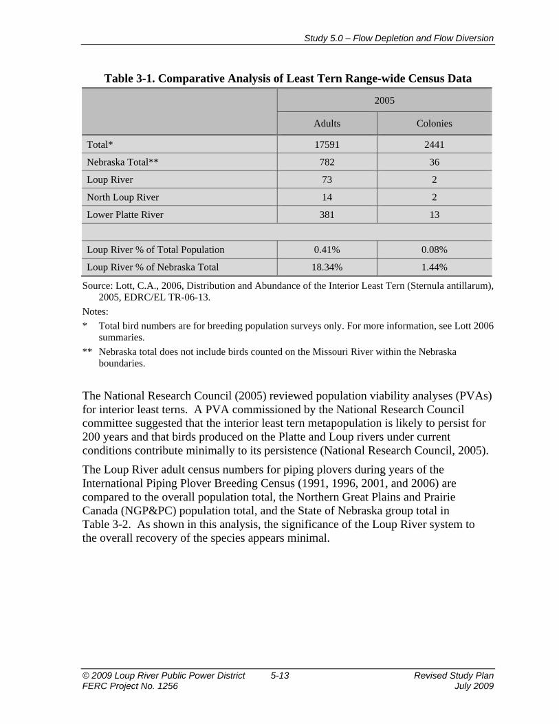
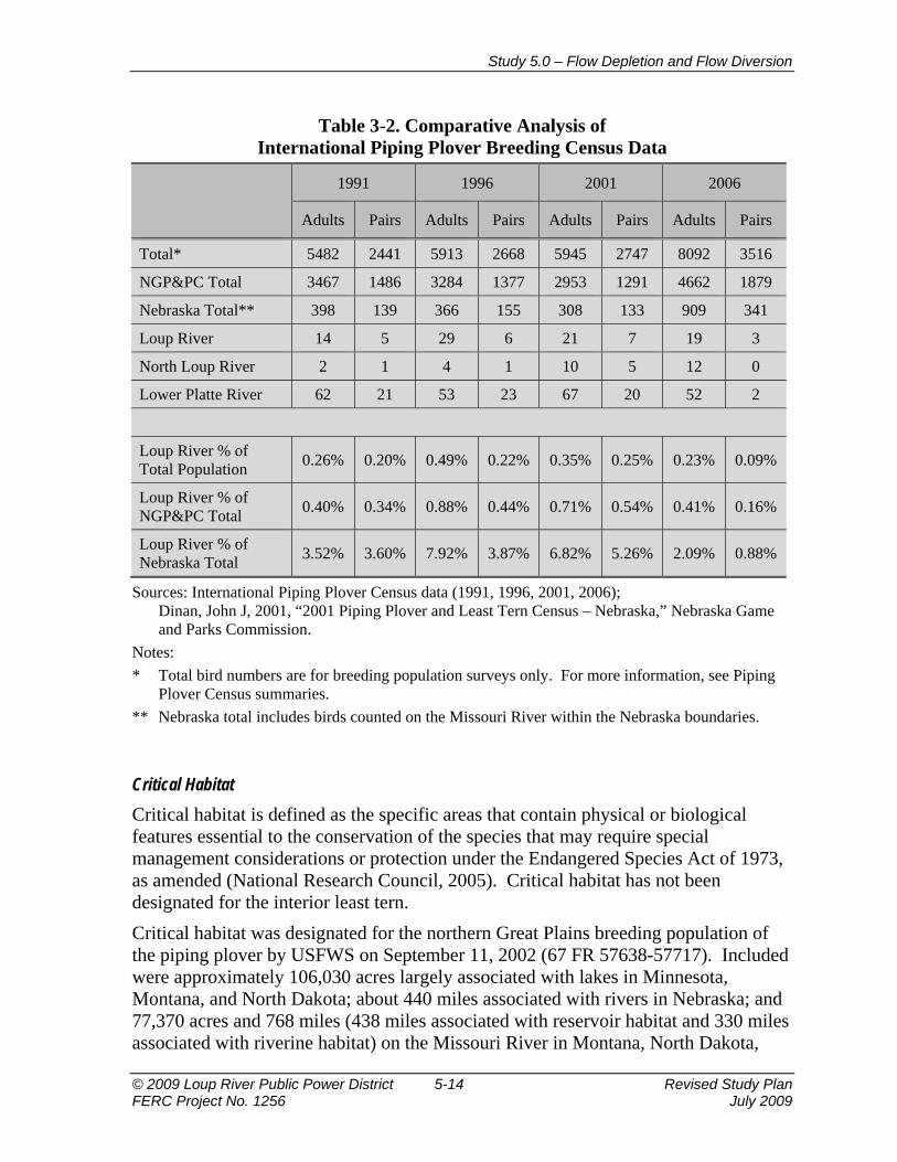
Bird Numbers on the Loup River with Respect to the Entire Interior/Great Plains Populations and Nebraska Breeding Numbers The Loup River adult census numbers for interior least terns during the 2005 Range-wide Least Tern Survey (Lott, 2006) are compared to the overall population total and the Platte River and tributaries group total in Table 3-1. As shown in this analysis, the significance of the Loup River system to the overall recovery of the species appears minimal. Very little data has been accumulated on the Loup River for interior least terns. Surveys on the Loup and Elkhorn rivers are conducted only in years of the International Piping Plover Census. Survey coverage of sandpits has improved in recent years on the Elkhorn, Loup, and North Loup rivers.
Study 5.0 – Flow Depletion and Flow Diversion
© 2009 Loup River Public Power District 5-13 Revised Study Plan FERC Project No. 1256 July 2009
Table 3-1. Comparative Analysis of Least Tern Range-wide Census Data
2005
Adults Colonies
Total* 17591 2441
Nebraska Total** 782 36
Loup River 73 2
North Loup River 14 2
Lower Platte River 381 13
Loup River % of Total Population 0.41% 0.08%
Loup River % of Nebraska Total 18.34% 1.44%
Source: Lott, C.A., 2006, Distribution and Abundance of the Interior Least Tern (Sternula antillarum), 2005, EDRC/EL TR-06-13.
Notes: * Total bird numbers are for breeding population surveys only. For more information, see Lott 2006
summaries. ** Nebraska total does not include birds counted on the Missouri River within the Nebraska
boundaries.
The National Research Council (2005) reviewed population viability analyses (PVAs) for interior least terns. A PVA commissioned by the National Research Council committee suggested that the interior least tern metapopulation is likely to persist for 200 years and that birds produced on the Platte and Loup rivers under current conditions contribute minimally to its persistence (National Research Council, 2005). The Loup River adult census numbers for piping plovers during years of the International Piping Plover Breeding Census (1991, 1996, 2001, and 2006) are compared to the overall population total, the Northern Great Plains and Prairie Canada (NGP&PC) population total, and the State of Nebraska group total in Table 3-2. As shown in this analysis, the significance of the Loup River system to the overall recovery of the species appears minimal.
Study 5.0 – Flow Depletion and Flow Diversion
© 2009 Loup River Public Power District 5-14 Revised Study Plan FERC Project No. 1256 July 2009
Table 3-2. Comparative Analysis of International Piping Plover Breeding Census Data
1991 1996 2001 2006
Adults Pairs Adults Pairs Adults Pairs Adults Pairs
Total* 5482 2441 5913 2668 5945 2747 8092 3516
NGP&PC Total 3467 1486 3284 1377 2953 1291 4662 1879
Nebraska Total** 398 139 366 155 308 133 909 341
Loup River 14 5 29 6 21 7 19 3
North Loup River 2 1 4 1 10 5 12 0
Lower Platte River 62 21 53 23 67 20 52 2
Loup River % of Total Population 0.26% 0.20% 0.49% 0.22% 0.35% 0.25% 0.23% 0.09%
Loup River % of NGP&PC Total 0.40% 0.34% 0.88% 0.44% 0.71% 0.54% 0.41% 0.16%
Loup River % of Nebraska Total 3.52% 3.60% 7.92% 3.87% 6.82% 5.26% 2.09% 0.88%
Sources: International Piping Plover Census data (1991, 1996, 2001, 2006); Dinan, John J, 2001, “2001 Piping Plover and Least Tern Census – Nebraska,” Nebraska Game and Parks Commission.
Notes: * Total bird numbers are for breeding population surveys only. For more information, see Piping
Plover Census summaries. ** Nebraska total includes birds counted on the Missouri River within the Nebraska boundaries.
Critical Habitat Critical habitat is defined as the specific areas that contain physical or biological features essential to the conservation of the species that may require special management considerations or protection under the Endangered Species Act of 1973, as amended (National Research Council, 2005). Critical habitat has not been designated for the interior least tern. Critical habitat was designated for the northern Great Plains breeding population of the piping plover by USFWS on September 11, 2002 (67 FR 57638-57717). Included were approximately 106,030 acres largely associated with lakes in Minnesota, Montana, and North Dakota; about 440 miles associated with rivers in Nebraska; and 77,370 acres and 768 miles (438 miles associated with reservoir habitat and 330 miles associated with riverine habitat) on the Missouri River in Montana, North Dakota,

Study 5.0 – Flow Depletion and Flow Diversion
© 2009 Loup River Public Power District 5-15 Revised Study Plan FERC Project No. 1256 July 2009
South Dakota, and Nebraska. The final rule reported that for piping plovers breeding on the northern Great Plains in the United States, about 69 percent used the lake habitat and the remaining 31 percent were found on habitat associated with Missouri River reservoirs, tributaries to the Missouri River (such as the Platte and Niobrara rivers), and the Missouri River. Critical habitat was not designated for northern Great Plains piping plovers breeding in Canada. The critical habitat designation in Nebraska included the Platte River from Lexington, Nebraska, to the confluence of the Platte with the Missouri River (252 miles), the Loup River (68 miles), and the eastern portion of the Niobrara River (120 miles). The shoreline of Lake McConaughy was excluded because USFWS maintained that it was adequately managed under plans developed by the Central Nebraska Public Power and Irrigation District. USFWS also excluded sand pits because they do not meet the physical and biological requirements of critical habitat (National Research Council, 2005). On February 14, 2003, the Nebraska Habitat Conservation Coalition filed a lawsuit against USFWS before the U.S. District Court in Nebraska. The lawsuit was filed to invalidate the designation of critical habitat for piping plovers in Nebraska. On October 13, 2005, the Nebraska Habitat Conservation Coalition was awarded the case against USFWS. U.S. District Judge Lyle Strom vacated and remanded all critical habitat designations on the Platte, Loup, and Niobrara rivers. The critical habitat designation on the Missouri River along the Nebraska/South Dakota border still stands. Judge Strom ordered USFWS to re-conduct the economic analysis and re-assess the critical habitat designation for the piping plover in Nebraska (U.S. District Court for the District of Nebraska, October 13, 2005). Because of this decision, there is currently no Federally designated critical habitat for piping plover within the state of Nebraska and in the vicinity of the Project.
River Habitat Climatic conditions that influence river hydrology are a major factor influencing the braided river morphology, which translates to the distribution, abundance, and quality of nesting habitat. Riverine habitat is constantly changing and is formed and maintained by the hydrology of the river and the supply and movement of its alluvial bed material (USFWS, June 16, 2006). Riverine nesting areas of interior least terns and piping plovers consist of sparsely vegetated sand and gravel bars within a wide unobstructed river channel. Nesting locations are usually at higher elevations and away from the water’s edge. Interior least terns and piping plovers have been observed to nest on sandbar habitats with less than 25 percent vegetative cover and an abundance of bare or sparsely vegetated sand and gravel (Sidle and Kirsch, 1993) with an average area of 1.45 hectares and at an average height of 0.49 meter (Ziewitz et al., 1992). In a preliminary assessment of river nesting habitat, Brown and Jorgensen (2008) assessed nine sandbars with nesting interior least tern colonies and fifteen sandbars

Study 5.0 – Flow Depletion and Flow Diversion
© 2009 Loup River Public Power District 5-16 Revised Study Plan FERC Project No. 1256 July 2009
without nesting colonies from June 28 to July 3, 2008. The goal of this study was to assess the amount and quality of sandbar habitat available to the birds in the lower Platte River. The researchers systematically measured the physical characteristics of sandbars with nesting birds and sandbars without nesting birds. This assessment was conducted on the lower Platte River from River Mile 57 (near Fremont, Nebraska) downstream to the confluence of the Platte and Missouri rivers (near Plattsmouth). Sandbar surface area and elevation above the water line were measured and used to determine sandbar “size.” River flow measurements from gage stations were used to show the relationship between flow changes and whether a sandbar and the nests on it were inundated or remained dry. This study followed a period of very high flows on the Platte River. On May 31, 2008, the average daily discharge was 96,000 cfs at the USGS gage at Louisville, Nebraska, which is in the top 10 of daily peak discharges for the period of record (1953 to 2009). In addition, the flow volume during that period was approximately 150 percent of normal at Louisville. This higher-than-average event may have caused certain outcomes to be different than a normal flow year. The results of this assessment showed that average sandbar area and height, with and without nests, were relatively similar. Throughout the study, no interior least tern nests were inundated, despite notable river rises due to weather conditions. One piping plover nest at a relatively low elevation was inundated.
Non-River Habitat Operating sand and gravel pits provide a barren to sparsely vegetated substrate suitable for nesting habitat (Sidle, 1993). Kirsch (1996) characterized sandpit sites as expansive areas of sand with large surface areas of water. Sidle (1993) identified 32 sandpits and the District’s Sand Management Area as suitable for nesting interior least terns and piping plovers. Sidle found that most sandpits examined ranged in size from 0.6 to 79.6 hectares (ha) and averaged 23 ha with the District’s Sand Management Area being an outlier at 200.8 ha. The sand and gravel component of sandpits ranged from 0.2 to 37.3 ha, and the water component ranged from 0.4 to 42.3 ha. The District’s Sand Management Area was approximately 172.2 ha of sand and gravel and 28.6 ha of water (Sidle, 1993). Due to recent trends in management of interior least terns and piping plovers, including directing nest sites, monitoring, vegetation control, and predator exclusion and management, many commercial sandpits and sandpit lakeshore housing developments are successfully being used by these species. Brown et al. (2008) reported a steady increase in both interior least terns and piping plovers nesting at non-river habitat over the past 20 years. Jenniges and Plettner (2008) found that productivity at managed sandpits was significantly higher than at unmanaged pits during the same time frame, indicating that management is effective in improving productivity of interior least terns.

Study 5.0 – Flow Depletion and Flow Diversion
© 2009 Loup River Public Power District 5-17 Revised Study Plan FERC Project No. 1256 July 2009
The District’s North Sand Management Area has provided consistent habitat for nesting interior least terns and piping plovers for a number of years and continually has the largest documented nesting colony of interior least terns and piping plovers located along the Loup River system (NGPC, 2009). Current management practices at the District’s North Sand Management Area have used a combination of directing nest sites, protective sand berms, redirecting dredge discharge flow, and interior least tern and piping plover nest monitoring. These management practices, developed in conjunction with the North Sand Management Area Adaptive Management Plan, have helped to increase bird awareness and to allow these species to successfully coexist with the dredging and sand operations (Tern and Plover Conservation Partnership, July 30, 2008).
Interior Least Tern and Piping Plover Data The Nebraska Least Tern and Piping Plover database maintained by the NGPC Nongame Bird Program is the most up-to-date and comprehensive available data source on the occurrence and distribution of Nebraska’s interior least terns and piping plovers. The NGPC Nongame Bird Program maintains high standards of data quality control; however, “it makes no warranty as to the fitness of these data for any purpose nor that these data are necessarily accurate and complete” (NGPC, 2009). NGPC notes that the data have inherent limitations (NGPC, 2009). Some sites, both natural and human-created, in the state have been surveyed using different methodologies at different times and for different lengths of time. Accurately quantifying the number of individual interior least terns and piping plovers at a site is challenging because both species are very mobile. Interior least terns often forage several miles away from nesting sites. Individual birds may colonize and then leave sites in response to nest failure throughout the nesting season. Observers are not always able to detect all individuals at a site all of the time (Brown and Jorgensen, September 5, 2008). The District was granted access to information on interior least terns and piping plovers on the Loup and lower Platte rivers from NGPC’s Nongame Bird Program Nebraska Least Tern and Piping Plover database on July 24, 2009 (NGPC, 2009). The District also has collected information on interior least terns and piping plovers on the Missouri River (the Fort Randall and Gavins Point reaches) from the U.S. Army Corps of Engineers (USACE) (USACE, March 30, 2009) and on the Niobrara River from the National Park Service (National Park Service, June 30, 2009). Finally, the District has gathered information from the International Piping Plover Breeding Census on Nebraska rivers and sandpits (Elliot-Smith, February 17, 2009) and the Range-wide Least Tern Census (Lott, 2006). A table of the data available for use in the sedimentation study is provided in Attachment A.

Study 5.0 – Flow Depletion and Flow Diversion
© 2009 Loup River Public Power District 5-18 Revised Study Plan FERC Project No. 1256 July 2009
3.5.3 Pallid Sturgeon The pallid sturgeon is considered to be a large turbid river species. The habitat used by different life stages of this species varies widely. Historically, most rivers comprising the range of the pallid sturgeon were characterized by shallow channels with shifting sandbars. The lower Platte River still retains this type of habitat over most of its length. Pallid sturgeon in the lower Platte River use areas associated with the downstream ends of sandbars and in deeper channels along the edge of sandbars (Peters and Parham, 2008; Swigle, 2003). Between 2001 and 2004, pallid sturgeon in the Platte River were caught in sampling gear as early as April 2 and as late as September 25. From this group, individuals implanted with radios all exited the Platte River by June 9 (Peters and Parham, 2008; Swigle, 2003). Of 25 hatchery-reared pallid sturgeon juveniles implanted and released in the Platte River during April 1998 and April 1999, six individuals either remained in the Platte throughout the year or returned to the Platte from the Missouri River the spring following their release (Snook, 2001, as cited in Peters and Parham, 2008). Pallid sturgeon have been found to use the deepest water available in the Platte River, using depths ranging from 0.33 to 1.27 meters, with average column velocities in the range of 0.52 to 0.82 meters per second (Peters and Parham, 2008). Many studies have noted the preponderance of use of sand substrate by pallid sturgeon. In the Platte River, average percentages of sand, silt, and gravel at pallid sturgeon telemetry contacts were 99.9 percent, 0.4 percent, and 0 percent, respectively (Peters and Parham, 2008).
4. PROJECT NEXUS “Explain any nexus between project operations and effects (direct, indirect, and/or cumulative) on the resource to be studied;” 18 CFR §5.11(d)(4) The Project diverts water from the Loup River near Genoa into the Loup Power Canal and then releases diverted water into the Platte River through the Tailrace Canal at Columbus, approximately 2 miles downstream of the confluence of the Loup and Platte rivers. Project operations and any net consumptive losses resulting from water diversion from the Loup River to the Loup Power Canal may or may not affect habitat used by interior least terns and piping plovers and habitat connectivity for fish (including the pallid sturgeon in the lower Platte River, below the confluence with the Elkhorn River) and other riverine species in the Loup River bypass reach and the lower Platte River compared to alternative conditions.
Study 5.0 – Flow Depletion and Flow Diversion
© 2009 Loup River Public Power District 5-19 Revised Study Plan FERC Project No. 1256 July 2009
5. STUDY AREA AND STUDY SITES The study area is the Loup Power Canal and associated regulating reservoirs; the Loup River bypass reach, which begins at the Diversion Weir, located west of Genoa, and ends at the confluence with the Platte River at Columbus (see Figure 5-1); and the lower Platte River from the confluence with the Loup River to the USGS gage at North Bend. There are seven study sites within the study area where data will be collected. These sites are the USGS and NDNR gages listed in Section 3.2, Available Flow Data. An eighth study site is immediately upstream of the Diversion Weir.
6. PROPOSED METHODOLOGY “A detailed description of the study and the methodology to be used;” 18 CFR §5.11(b)(1) “Explain how any proposed study methodology (including any preferred data collection and analysis techniques, or objectively quantified information, and a schedule including appropriate field season(s) and the duration) is consistent with generally accepted practice in the scientific community or, as appropriate, considers any known tribal interests;” 18 CFR §5.11(d)(5)
The methodology for the flow depletion and flow diversion study includes seven tasks designed to meet the six objectives presented in Section 1, Goals and Objectives of Study. These objectives are repeated below, and the tasks that will be conducted to meet each objective follow. Task 1, Data Collection, is required prior to initiation of the other tasks and is not associated with one specific objective. The period of analysis varies by task.
Task 1 Data Collection Flow and stage data will be collected for each gage listed in Section 3.2. This will include all available flow data for the period of record along with the current and historic rating curves. Available atmospheric data, including pan evaporation, precipitation, and temperature, will be obtained from NWS stations for the years 1980 through 2009. This range of data was selected because it includes a moderate flow period (1980 to 1992), a wet period (1993 to 1998), and a dry period (1999 to 2009). Other information that will be used in Task 2, Net Consumptive Use, will also be collected. This will include soil survey data and aerial and satellite images of the vegetation along the Loup River bypass reach. This data will also be obtained for the years 1980 through 2009.

Study 5.0 – Flow Depletion and Flow Diversion
© 2009 Loup River Public Power District 5-20 Revised Study Plan FERC Project No. 1256 July 2009
Objective 1: To determine the net consumptive losses associated with Project operations compared to alternative conditions
Objective 5: To determine Project effects, if any, of consumptive use on fisheries and habitat on the lower Platte River downstream of the Tailrace Canal.
Task 2 Net Consumptive Use During preparation of the PAD, flow depletions on the lower Platte River associated with the Loup Power Canal were estimated through development of an annual water budget. Incremental and cumulative water budgets were developed for the Loup Power Canal using USGS Gage 06792500 on the Loup Power Canal near Genoa, power generation records at the Columbus Powerhouse, and NDNR Gage 00082100 on the Tailrace Canal at Columbus. This task will build upon the flow depletion calculations described in the PAD by calculating monthly and seasonal net consumptive use for the years 1980 through 2009. Net consumptive use will be calculated for the Loup Power Canal and Loup River bypass reach for current Project operations and for alternative conditions. Consumptive use losses are calculated by adding open water evaporative losses and ET losses from native vegetation and agricultural crops. Irrigation return water and groundwater seepage eventually make it back to the Loup River or the lower Platte River. Although slightly time-lagged, these flows are not removed from the system and therefore are not considered consumptive losses. This assumption is supported by the 10/50 line analysis performed by NDNR (October 2007) for hydraulically connected areas in the lower Platte River Basin.
Consumptive Use in the Loup Power Canal and Associated Regulating Reservoirs
Consumptive use in the Loup Power Canal and associated regulating reservoirs will be calculated on a monthly and seasonal basis by adding the ET consumptive use losses and the evaporation consumptive use losses. Monthly open water evaporative losses for the Loup Power Canal and regulating reservoirs will be estimated by using the total surface area exposed to the atmosphere and a relationship of lake to pan evaporation data collected from the NWS stations. Surface area will be calculated from channel widths, length, and reservoir areas.
Consumptive Use in the Loup River Bypass Reach
Consumptive use in the Loup River bypass reach will be calculated on a monthly and seasonal basis by adding the ET consumptive use losses and the evaporation consumptive use losses. There are only two surface water rights holders along the Loup River bypass reach. The impact from these is considered negligible and will not be considered further.

Study 5.0 – Flow Depletion and Flow Diversion
© 2009 Loup River Public Power District 5-21 Revised Study Plan FERC Project No. 1256 July 2009
Consumptive losses due to ET from the trees and other large vegetation bordering the Loup River bypass reach will be calculated by tabulating the length of riparian vegetation bordering the bypass reach (observed from aerial photographs and satellite images) and estimating an ET rate per unit length. Data on riparian-area ET acquired by USGS for the Nebraska Cooperative Hydrology Study (COHYST) in the central Platte River will be acquired and assessed for applicability. Monthly open water evaporative losses for the Loup River bypass reach will be estimated by using the surface area and evaporation data collected from the NWS stations. Surface area will be calculated from channel cross sectional top width and distance between USGS gages. The top width will be based on the 50 percent exceedance discharge, the surveyed USGS cross section, and the USGS rating curve.
Net Consumptive Use
The net consumptive use will be estimated by taking the difference between the consumptive use losses in the Loup Power Canal and regulating reservoirs and the consumptive use losses in the Loup River bypass reach. Values will be estimated on a monthly, seasonal, and annual basis for the period 1980 through 2009 for current Project conditions and alternative conditions. If Project operations result in less flow depletion in the lower Platte River than the alternative conditions, it can be concluded that Project operations do not adversely impact, and may benefit, fisheries and aquatic habitat relative to flow depletions. If Project operations result in an increase in flow depletions as compared to alternative conditions, then the District will assess implications of the depletions on lower Platte River morphology and will coordinate with the agencies as needed to determine reasonable and prudent alternatives or mitigation.
Objective 2: To use current and historic USGS gage rating curves to evaluate change in stage in the Loup River bypass reach during Project operations and compare against alternative hydrographs.
Task 3 Flow Duration and Flood Frequency Curves Existing gage data will be used to develop flood frequency and flow duration curves in the Loup River bypass reach for current Project operations and for alternative operations. Flow duration curves will be created for the USGS gage on the Loup River near Genoa, the USGS gage on the Loup River at Columbus, and the synthetic point just upstream of the Diversion Weir for the period of record. As previously stated, the USGS gage on the Loup River at Columbus was discontinued in 1978. Therefore, a relationship between the Loup River near Genoa and the Loup River at Columbus will be determined based on data from the coincident period of record between the gages.
Study 5.0 – Flow Depletion and Flow Diversion
© 2009 Loup River Public Power District 5-22 Revised Study Plan FERC Project No. 1256 July 2009
Data from the USGS gage on the Loup River at Columbus will then be extrapolated based on this relationship to match the period of record for data from the USGS gage on the Loup River near Genoa. The median discharge value for each site will be determined graphically as the flow associated with the 50 percent exceedance on the respective flow duration curve. Flood frequency curves will also be generated at each study site for the period of record using the U.S. Army Corps of Engineers HEC-FFA. Alternative flow duration and flood frequency at each gage will be synthesized using gage data. Conservation of mass will be verified using the flow volume of the gages.
Task 4 Stage The stage in the Loup River bypass reach at Genoa and Columbus will be evaluated using current and historic USGS rating curves and the results from Task 3, Flow Duration and Flood Frequency Curves. The stage for Project operations will be compared with the stage for alternative conditions to obtain change in stage for the 25, 50, and 75 percent chance exceedance discharges for the time period of 1980 through 2009. If the Project operations stage is not materially different from an alternative stage, then it can be concluded that Project operations do not impact stage in the Loup River bypass reach. If the Project operations stage is materially different from an alternative stage, then the District will assess implications to the species of the magnitudes and frequencies of the stage changes on the Loup River bypass reach and will coordinate with the agencies as needed to determine reasonable and prudent alternatives or mitigation.
Objective 3: To evaluate historic flow trends on the Loup and Platte rivers since Project inception.
Task 5 Loup River and Platte River Depletions Historic flow records will be evaluated to determine the general flow trend (increasing, decreasing, or relatively constant) in the Loup and Platte rivers. USGS gages on the Loup River at Genoa and Columbus and USGS gages on the Platte River at Duncan and North Bend will be evaluated. A USGS report (Ginting, Zelt, and Linard, 2008) and other similar reports will be used to assess flow depletions in the Platte River. This information will be used as the baseline to evaluate Project-related effects.
Study 5.0 – Flow Depletion and Flow Diversion
© 2009 Loup River Public Power District 5-23 Revised Study Plan FERC Project No. 1256 July 2009
Objective 4: To determine the extent of interior least tern and piping plover nesting on the Loup River above and below the Diversion Weir.
Task 6 Interior Least Tern and Piping Plover Nesting on the Loup River Bypass Reach Existing information from NGPC on interior least tern and piping plover nesting activities upstream and downstream of the Diversion Weir on the Loup River will be collected. Nest occurrence above the Diversion Weir will be compared to nest occurrence below the Diversion Weir to the Project tailrace confluence. Recorded nesting sites on the Loup River for both species from all available years (see Attachment A) will be plotted using ArcGIS. If no significant differences in nest occurrences exist, then it can be concluded that Project operations do not impact stage in the Loup River bypass reach. This is based on the assumption that the natural nesting conditions above and below the Diversion Weir are similar. If significant differences in occurrence do exist, then the riparian corridors for equal distances (approximately 5 to 10 miles) above and below the Diversion Weir will be examined. The exact distance and areas to be examined will be determined after evaluation of the interior least tern and piping plover nesting location data. This information will be provided for agency review during the study period in a quarterly report. U.S. Department of Agriculture, Natural Resources Conservation Service aerial images and images from other comparable sources for appropriate reaches of the Loup River, both upstream and downstream of the Diversion Weir, will be examined to identify and compare habitat parameters using the same methodology used by Kirsch (1996). The following parameters will be identified: number, position, and average size of bare sand areas within the banks of the river; channel width; percent un-vegetated sandbars; percent vegetated sandbars (isolated and non-isolated); and presence and/or type of vegetation. The observed conditions for each year for these parameters will be compared to determine to what extent flow diversion and the presence of the Diversion Weir may result in different river and riparian vegetation conditions. In addition, habitat requirements of the interior least tern and piping plover will be identified using existing literature. Observed habitat parameters (listed above) on the Loup River will be compared to habitat requirements to determine if any changes in the riparian corridor may have had an effect on the occurrence of these species. These habitat parameters will then be compared to the habitat associated with the alternative conditions to determine if any of the alternative conditions would result in improvements to the habitat parameters.

Study 5.0 – Flow Depletion and Flow Diversion
© 2009 Loup River Public Power District 5-24 Revised Study Plan FERC Project No. 1256 July 2009
Objective 6: To determine the relative significance of the Loup River bypass reach to the overall fishery habitat for the Loup River.
Task 7 Fishery Populations Above and Below the Diversion Weir Data collected during 1996 and 1997 NGPC fish sampling efforts on the Loup River will be used to analyze fish populations above and below the Diversion Weir (NGPC, June 1997 and April 1998). Ultimately, the extent to which flow diversion may or may not result in different species populations upstream and downstream of the Diversion Weir will be determined. In addition, the flow information developed in Task 3, Flow Duration and Flood Frequency Curves, will be used to calculate the opportunity for fish species to migrate upstream of the Diversion Weir during high flows when the Diversion Weir is submerged or the sluice gates are raised. If no significant differences in species diversity or richness exist, then it can be concluded that Project operations do not affect fishery populations in the Loup River bypass reach.
7. CONSULTATION WITH AGENCIES, TRIBES, AND OTHER STAKEHOLDERS This study plan has been developed based on discussions with agencies prior to submittal of the PAD and during multiple study plan meetings that followed the submittal of the Proposed Study Plan. The District presented an overview of the goals, objectives, and activities associated with Study 5.0, Flow Depletion and Flow Diversion, at the Study Plan Meeting held on April 21, 2009. Additionally, the goals and objectives of the aquatic resources studies, including Study 5.0, were discussed in detail. The meeting was attended by representatives of FERC, NGPC, NDEQ, USFWS, and National Park Service, as well as others. During this meeting, the following new objective was added to the study: to determine Project effects, if any, of consumptive use on fisheries and habitat on the lower Platte River downstream of the Tailrace Canal. In addition, objectives were clarified to eliminate references to specific activities as a result of this meeting. The District conducted an additional Study Plan Meeting on May 27-28, 2009, to discuss in more depth the specific activities associated with aquatic resources studies, including Study 5.0, Flow Depletion and Flow Diversion. Most of the attendees at the April 21, 2009, meeting (listed above) also attended this meeting. Discussion specific to this flow depletion and flow diversion study ultimately resulted in the following revisions to the study plan:
• Interior least tern and piping plover productivity analysis has been added to the activities associated with Objective 4.
• The geographic scope of aerial photo interpretation has been modified for Objective 4.

Study 5.0 – Flow Depletion and Flow Diversion
© 2009 Loup River Public Power District 5-25 Revised Study Plan FERC Project No. 1256 July 2009
• Activities associated with Objective 6 have been expanded to include seasonal analysis of Loup River fishery dynamics above and below the Diversion Weir.
The discussions from both meetings were documented in meeting transcripts, which are available on the District’s relicensing website (http://www.loup.com/relicense/html/agencymeetingsresources.html). USFWS provided comments related to Study 5.0, Flow Depletion and Flow Diversion, in its June 24, 2009, comment letter. The District’s response to these comments is included in Attachment B.
8. WORK PRODUCTS “Provisions for periodic progress reports, including the manner and extent to which information will be shared; and sufficient time for technical review of the analysis and results;” 18 CFR §5.11(b)(3) The intended work product for the flow depletion and flow diversion study is a study report. The study report will document the magnitude of flow reduction in the Loup River bypass reach. Along with the study report, a database of the data gathered and used in the analysis will be available. Updates regarding the flow depletion and flow diversion study will be included in the study progress reports to be submitted to FERC in December 2009, March 2010, and June 2010.
9. LEVEL OF EFFORT AND COST “Describe considerations of level of effort and cost, as applicable.” 18 CFR §5.11(d)(6) It is estimated that the flow depletion and flow diversion study will cost approximately $170,000. This work will be completed by qualified water resources engineers and biologists.
10. SCHEDULE “A schedule for conducting the study;” 18 CFR §5.11(b)(2) “The potential applicant's proposed study plan must also include provisions for the initial and updated study reports and meetings provided for in §5.15.” 18 CFR §5.11(c) The study will begin in the fourth quarter 2009 and be completed by the fourth quarter of 2010. The Flow Depletion and Flow Diversion study report will be available in the fourth quarter of 2010. In addition, the District will prepare a consolidated Initial Study Report for Studies 1.0 through 12.0 that describes progress and results (as appropriate) for each study. In accordance with the District’s Process Plan and

Study 5.0 – Flow Depletion and Flow Diversion
© 2009 Loup River Public Power District 5-26 Revised Study Plan FERC Project No. 1256 July 2009
Schedule, the Initial Study Report will be available in August 2010, and a study meeting will be held within 15 days, per 18 CFR §5.15(c)(2). An Updated Study Report will be available in August 2011 to provide information on progress and results for second season studies (as needed).
11. REFERENCES 67 FR 57637-57717. September 11, 2002. Endangered and Threatened Wildlife and
Plants; Designation of Critical Habitat for the Northern Great Plains Breeding Population of the Piping Plover; Final Rule. Department of the Interior, Fish and Wildlife Service.
16 USC 661 et seq. Fish and Wildlife Coordination Act, as amended. 16 USC 668a-d. Bald and Golden Eagle Protection Act, as amended. 16 USC 703-712. Migratory Bird Treaty Act, as amended. 16 USC 1531-1544. Endangered Species Act of 1973, as amended. 42 USC 4321-4347. National Environmental Policy Act of 1969, as amended. Bliss, Q.P., and S. Schainost. 1973. Middle Platte basin stream survey report.
Prepared for the Nebraska Game and Parks Commission, Lincoln, Nebraska. Brown, M.B., and J.G. Jorgensen. 2008. 2008 Interior Least Tern and Piping Plover
Monitoring, Research, Management, and Outreach Report for the Lower Platte River, Nebraska. Joint Report of the Tern and Plover Conservation Partnership and the Nebraska Game and Parks Commission.
Brown, Mary Bomberger, and Joel Jorgensen. September 5, 2008. Letter from Joel Jorgensen, Nongame Bird Program Manager, NGPC, and Mary Bomberger Brown, Program Coordinator, Tern and Plover Conservation Partnership, to Lisa Richardson, HDR, regarding information on interior least terns and piping plovers.
Brown, M.B., J.G. Jorgensen, and S.E. Rehme. 2008. Endangered species responses to natural habitat declines: Nebraska’s interior least terns (Sternula antillarum athalassos) and piping plovers (Charadrius melodus) nesting in a human-created habitat. The Nebraska Bird Review. 76(2):72-81.
Dinan, John J. 2001. 2001 Piping Plover and Least Tern Census - Nebraska. Nebraska Game and Parks Commission.
Ducey, J. 1985. The historic breeding distribution of the least tern in Nebraska. Nebraska Bird Review. 54(4): 72-73.
Ducey, J. 2000. Birds of the untamed west: the history of birdlife in Nebraska, 1750 to 1875. Making History, Omaha, Nebraska.

Study 5.0 – Flow Depletion and Flow Diversion
© 2009 Loup River Public Power District 5-27 Revised Study Plan FERC Project No. 1256 July 2009
Elliot-Smith, Elise. February 17, 2009. Personal communication with Elise Elliot-Smith, International Piping Plover Census, and Melissa Marinovich, Environmental Scientist, HDR.
Ginting, Daniel, Ronald B. Zelt, and Joshua I. Linard. 2008. “Temporal Differences in the Hydrologic Regime of the Lower Platte River, Nebraska, 1895-2006.” USGS Scientific Investigations Report 2007-5267. Available online at http://pubs.usgs.gov/sir/2007/5267/.
Heinemann, L.D. 1944. Nesting of the piping plover and least tern. Nebraska Bird Review. 12:9-10.
Jenniges, J.J., and R.G. Plettner. 2008. Least tern nesting at human created habitats in central Nebraska. Waterbirds. 31(2):274-282.
Jorgensen, J.G. 2007. Lower Platte River least tern and piping plover nesting survey. Nebraska W-15-R report. Nebraska Game and Parks Commission, Lincoln, Nebraska.
Kirsch, E.M. 1996. Habitat selection and productivity of least terns on the lower Platte River, Nebraska. Wildlife Monograph no. 132.
Lingle, G.R. 1993. Causes of nest failure and mortality of least terns and piping plovers along the central Platte River. In Proceedings, the Missouri River and its tributaries: piping plover and least tern symposium. South Dakota State University, Brookings, South Dakota.
Lott, C.A. 2006. Distribution and abundance of the interior population of the least tern (Sternula antillarum), 2005. U.S. Army Corps of Engineers. ERDC/EL TR-06-13.
National Park Service. June 30, 2009. Personal communication between Stephen K. Wilson, Resource Management/GIS Specialist, Missouri National Recreational River, National Park Service, and Melissa Marinovich, Environmental Scientist, HDR.
National Research Council. 2005. Endangered and Threatened Species of the Platte River. Washington, D.C.: The National Academies Press.
NDNR. October 2007. “2008 Annual Evaluation of Availability of Hydrologically Connected Water Supplies.” Lincoln, NE. Available online at http://www.nlc.state.ne.us/epubs/N1500/A005-2008.pdf.
NGPC. June 1997. Angler Use and Fish Community Dynamics in the Middle Loup and Loup River Basins and Sherman Reservoir. Annual Progress Report (March - November 1996). Fisheries Division.
NGPC. April 1998. Angler Use and Fish Community Dynamics in the Middle Loup and Loup River Basins and Sherman Reservoir. Annual Progress Report (March - November 1997). Fisheries Division.

Study 5.0 – Flow Depletion and Flow Diversion
© 2009 Loup River Public Power District 5-28 Revised Study Plan FERC Project No. 1256 July 2009
NGPC. December 2008. Assessment of the Pallid Sturgeon, Least Tern, and Piping Plover in the Lower Platte River. Nebraska Game and Parks Commission Report, Lincoln, Nebraska.
NGPC. 2009. Data provided under the “Nebraska Game and Parks Commission Nongame Bird Program Data Use Agreement” between NGPC and HDR, signed on June 24, 2009.
NOAA NCDC. August 2002. Cooperative Summary of the Day, TD3200. CD 1850-2001. Asheville, NC: National Climatic Data Center.
Parham, James E. 2007. “Hydrologic Analysis of the Lower Platte River from 1954-2004, with special emphasis on habitats of the Endangered Least Tern, Piping Plover, and Pallid Sturgeon.” Nebraska Game and Parks Commission.
Peters, Edward J., and James E. Parham. 2008. “Ecology and Management of Sturgeon in the Lower Platte River, Nebraska.” Nebraska Technical Series No. 18. Nebraska Game and Parks Commission. Lincoln, Nebraska.
PRRIP. October 24, 2006. Platte River Recovery Implementation Program Cooperative Agreement. Available online at http://platteriverprogram.org/Documents/PRRIP%20Program%20Agreement%20Final.pdf.
Schneider, Rick, Mark Humpert, Kristal Stoner, and Gerry Steinauer. 2005. The Nebraska Natural Legacy Project: A Comprehensive Wildlife Conservation Strategy. Nebraska Game and Parks Commission, Lincoln, Nebraska. Available online at http://www.ngpc.state.ne.us/wildlife/programs/legacy/review.asp.
Sharpe, R.S., W.R. Silcock, J.G. Jorgensen. 2001. The birds of Nebraska: Their distribution and temporal occurrence. University of Nebraska Press, Lincoln.
Sidle, J.G. 1992. Flooding, Mortality, and Habitat Renewal for Least Terns and Piping Plovers. Colonial Waterbirds. 15(1):132-136.
Sidle, J.G. 1993. Least tern and piping plover use of sand and gravel pits along the Platte and Loup rivers, Nebraska. In Proceedings, the Missouri River and its tributaries: piping plover and least tern symposium. South Dakota State University, Brookings, South Dakota.
Sidle, John G., and Eileen M. Kirsch. 1993. “Least Tern and Piping Plover Nesting at Sand Pits in Nebraska.” Colonial Waterbirds. 16(2):139-148.
Swigle, B.D. 2003. Movements and Habitat Use by Shovelnose and Pallid Sturgeon in the Lower Platte River, Nebraska. M.S. Thesis, University of Nebraska, Lincoln.
Tern and Plover Conservation Partnership. July 30, 2008. Personal communication between Mary Bomberger Brown, Program Coordinator, Tern and Plover

Study 5.0 – Flow Depletion and Flow Diversion
© 2009 Loup River Public Power District 5-29 Revised Study Plan FERC Project No. 1256 July 2009
Conservation Partnership, and Melissa Marinovich, Environmental Scientist, HDR.
U.S. Department of the Interior, Bureau of Reclamation. September 2002. Proposed Title Transfer, Middle Loup Division Nebraska, Final Environmental Assessment. Available online at http://www.usbr.gov/gp/nepa/middle_loup_ea/contents.htm.
U.S. District Court for the District of Nebraska. October 13, 2005. Nebraska Habitat Conservation Coalition (P) v. U.S. Fish and Wildlife Service (D). Case: 4:03-cv-03059-LES-DLP. Document #: 53. Date Filed: 10/13/05.
USACE. March 30, 2009. Personal communication between Gregory Pavelka, Biologist, USACE, and Melissa Marinovich, Environmental Scientist, HDR.
USFWS. September 1990. “Recovery Plan for the Interior Population of the Least Tern (Sterna antillarum).” Twin Cites, MN: U.S. Fish and Wildlife Service.
USFWS. June 15, 1999. National Policy Issuance #99-01, Mission Statement. Retrieved on February 27, 2009. http://www.fws.gov/policy/npi99_01.html.
USFWS. November 30, 2000. Biological Opinion on the operation of the Missouri River main stem reservoir system, operation and maintenance of the Missouri River bank stabilization and navigation project and operation of the Kansas River reservoir system. U.S. Fish and Wildlife Service, Fort Snelling, Minnesota.
USFWS. June 16, 2006. Biological Opinion on the Platte River Recovery Implementation Program. U.S. Fish and Wildlife Service, Grand Island, Nebraska.
USFWS. February 9, 2009. Letter from June M. DeWeese, Nebraska Field Supervisor, to Ms. Kimberly Bose, Federal Energy Regulatory Commission, regarding comments on the Pre-Application and Scoping Documents for the Loup River Hydroelectric Project.
Wilson, E.C., W.A. Hubert, and S.H. Anderson. 1993. Nesting and foraging of least terns on sand pits in central Nebraska. The Southwestern Naturalist. 38(1):9-14.
Ziewitz, J.W., J.G. Sidle, and J.J. Dinan. 1992. “Habitat Conservation for Nesting Least Terns and Piping Plovers on the Platte River, Nebraska.” Prairie Naturalist. 24(1):1-20.

Study 5.0 – Flow Depletion and Flow Diversion
© 2009 Loup River Public Power District Revised Study Plan FERC Project No. 1256 July 2009
Attachment A – Available Interior Least Tern and Piping Plover Data

Attachment A Available Interior Least Tern and Piping Plover Data
© 2009 Loup River Public Power District 5-A1 Revised Study Plan FERC Project No. 1256
Table 1. Available Interior Least Tern and Piping Plover Data on the Loup River1,2 Interior Least Tern Data Piping Plover Data
Year Adult Count3 Nest Count4 Adult Count3 Nest Count4
Sandpits5 River6 Sandpits5 River6 Sandpits5 River6 Sandpits5 River6 1983 15 - 4 - 0 - 0 - 1985 - 48 - 0 - 0 - 0 1986 10 10 0 0 0 0 0 0 1987 44 X 42 15 8 - 11 5 1988 80 62 44 20 14 29 6 4 1989 X X 5 2 X X 7 0 1990 31 X 24 28 12 X 5 8 1991 93 117 0 28 30 48 0 9 1992 16 141 5 46 6 30 8 13 1993 4 42 11 19 7 16 5 5 1994 - - - - - - - - 1995 10 128 3 40 6 55 3 16 1996 17 49 5 10 10 5 - - 1997 14 - 12 - 10 - 5 - 1998 - 64 - 2 - 12 - 1 2000 2 - 1 - 0 - 0 - 2001 8 - 10 - 0 - 0 - 2002 - - - - - - - - 2003 X - 5 - X - 0 - 2004 X - 21 - X - 2 - 2005 58 19 43 - 16 0 15 - 2006 - 60 - 4 - - - 3 2007 32 - 18 - 8 - 5 - 2008 45 - 22 - 27 - 10 - 2009 - 75 - - - 7 - -
Sources: Dinan, John J., 2001, 2001 Piping Plover and Least Tern Census – Nebraska, NGPC. Jenniges, Jim, June 8, 2009, Personal communication (email) regarding the 2009 June Loup River least tern and piping plover river survey. NGPC Non-Game Bird Program Tern and Plover Database, 2009, unpublished data provided by NGPC, received on September 11, 2008; June 19, 2009; and July 16, 2009.
Notes: 1 The Loup River, for the purpose of these studies, is defined as the confluence with the North and Middle
Loup Rivers to the confluence with the Platte River. 2 An “X” indicates that there were numbers available for multiple day counts but they were not
summarized. A “-” indicates that there were no numbers provided for this year and habitat type. 3 Adult count is defined as the highest number of adults counted on a single survey day at a site during the
annual summer census. These numbers include individual birds with no known attachment to a nest (floaters) seen on- or off-river.
4 Nest count is defined as the total number of nests observed throughout the season. 5 Sandpits are defined as either sand and gravel mine spoil piles or housing development sand bottom lakes. 6 River sites are defined as located within the established banks of the river. These were identified either
by boat or aerial surveys.

Study 5.0 – Flow Depletion and Flow Diversion
© 2009 Loup River Public Power District Revised Study Plan FERC Project No. 1256 July 2009
Attachment B – Response to USFWS June 24, 2009, Study Comments
Attachment B Response to USFWS June 24, 2009, Study Comments
© 2009 Loup River Public Power District 5-B1 Revised Study Plan FERC Project No. 1256 July 2009
STUDY 5.0 FLOW DEPLETION AND FLOW DIVERSION RESPONSE TO USFWS JUNE 24, 2009, STUDY COMMENTS
INTRODUCTION In a letter dated June 24, 2009, the U.S. Fish and Wildlife Service (USFWS) provided comments on the District’s Proposed Study Plan (PSP) for the Project, as revised at the May 27-28, 2009, Study Plan Meeting. The District identified two general themes in USFWS’s comment letter that the District believes merit a general discussion. These are listed below and are discussed in detail in the sections that follow:
• USFWS provided a number of recommendations for changing the District’s proposed methodology. The District maintains that these changes are inconsistent with the National Environmental Policy Act of 1969 (NEPA).
• USFWS provided a number of recommendations for including cumulative effects analysis. The District maintains that these recommendations are inconsistent with NEPA guidance and USFWS’s Endangered Species Act of 1973 (ESA) procedures.
USFWS Recommended Changes to Proposed Methodology that are Inconsistent with CEQ’s NEPA Guidance Neither NEPA nor the ESA requires a specific methodology to analyze impacts. The standard for both laws is to conduct an analysis that is adequate for the Federal agency’s decision. Whatever methodology is used, it must provide an accurate and complete analysis. The Council on Environmental Quality (CEQ) guidance specifically states that the methodology and information used must avoid speculation about potential impacts and be the best information available. The District maintains that its PSP meets both of these criteria. Specifically, the District proposes to indirectly analyze impacts on threatened and endangered (T&E) species and the aquatic resources of the Loup River bypass reach and the lower Platte River by evaluating geomorphic stability of these reaches. This will be accomplished by determining if Project operations and alternate operating conditions impact this stability. This methodology is based on the fact that habitat is a direct function of geomorphic conditions. This analysis coupled with the hydrocycling analysis will provide FERC with an analysis of Project operations and alternative conditions that is adequate for its decision. In a number of comments (noted in specific responses provided below), USFWS criticizes the District’s proposed methodology based on the fact that it assesses impacts using an indirect measure rather than a direct measure. The District maintains that determining impacts via indirect methods using many years of historical data is the most appropriate method because the District is not proposing any changes to Project operations as part of the license application. Furthermore, the

Attachment B Response to USFWS June 24, 2009, Study Comments
© 2009 Loup River Public Power District 5-B2 Revised Study Plan FERC Project No. 1256 July 2009
District notes that the use of historical data provides the ability to evaluate alternatives under identical conditions, eliminating the effects of externalities in methods proposed by USFWS.
USFWS Made Recommendations on Cumulative Effects that are Inconsistent with CEQ’s NEPA Guidance and USFWS’s ESA Procedures In its comment letter, USFWS frequently explains that the District’s analysis should not be based on current hydrology, but should be based on projected hydrology derived from reasonably foreseeable effects on the hydrograph. The District’s main concern with this comment relates to USFWS’s position on how this projected hydrology should be determined. Per CEQ guidance, the standard methodology for evaluating cumulative effects is to use a historic baseline; to add the effects of past, present, and reasonably foreseeable future actions to that baseline; and then to add the incremental impacts of the proposed action to that total. Alternatively, it is acceptable to use the existing baseline as representing the cumulative effects of past and present actions, then to add the effects of reasonably foreseeable future actions to that, and then to add the incremental effects of the proposed action to that total. The latter of these two approaches is the one the District has proposed to use. None of the accepted methodologies uses USFWS’s recommendation of a projected baseline. Allied with this concern is USFWS’s position for determining what constitutes a reasonably foreseeable future action. CEQ’s guidance states that the future action must have progressed far enough in its implementation to have some degree of certainty that it will be implemented. These future actions are to have a specific description and some existing evaluation. Some of the examples that CEQ’s guidance provides to make this judgment of certainty include identified or allocated funding, regulatory applications or approvals, and environmental clearance applications or approvals. The intent of CEQ’s guidance is to make sure that future actions that are too speculative to have a high degree of certainty that they will be implemented are not included in the cumulative effects analysis. USFWS’s ESA procedures for determining reasonably foreseeable future actions are even more restrictive. The ESA procedures require that only actions that have completed Section 7 consultation be identified as reasonably foreseeable future actions. The stated rationale for this position is that under the ESA, any future action that could have an impact on a listed species must complete Section 7 consultation before it can be implemented. Therefore, any future action that has not completed Section 7 consultation has not met the reasonably foreseeable definition of certainty.

Attachment B Response to USFWS June 24, 2009, Study Comments
© 2009 Loup River Public Power District 5-B3 Revised Study Plan FERC Project No. 1256 July 2009
The District is concerned that USFWS’s comments may not be consistent with either CEQ’s NEPA guidance or its own ESA guidance because of its recommendation to use a baseline based on future conditions. On the surface, this recommendation appears to be inconsistent with CEQ’s baseline and reasonably foreseeable future action guidance as well as USFWS’s ESA guidance.
Organization of This Document USFWS organized its comments by study objective and provided specific comments related to the following seven study criteria, as presented in 18 CFR §5.9(b): (1) Describe the goals and objectives of each study proposal and the information to be obtained; (2) If applicable, explain the relevant resource management goals of the agencies or Indian tribes with jurisdiction over the resource to be studied; (3) If the requester is a not resource agency, explain any relevant public interest considerations in regard to the proposed study; (USFWS is a resource agency; therefore, USFWS did not comment on this study criteria.) (4) Describe existing information concerning the subject of the study proposal, and the need for additional information; (5) Explain any nexus between project operations and effects (direct, indirect, and/or cumulative) on the resource to be studied, and how the study results would inform the development of license requirements; (6) Explain how any proposed study methodology (including any preferred data collection and analysis techniques, or objectively quantified information, and a schedule including appropriate filed [sic] season(s) and the duration) is consistent with generally accepted practice in the scientific community or, as appropriate, considers relevant tribal values and knowledge; and (7) Describe considerations of level of effort and cost, as applicable, and why any proposed alternative studies would not be sufficient to meet the stated information needs. This response is also organized by study objective and study criteria. Individual USFWS comments are presented in italic font exactly as received. Each comment is followed by the District’s response.

Attachment B Response to USFWS June 24, 2009, Study Comments
© 2009 Loup River Public Power District 5-B4 Revised Study Plan FERC Project No. 1256 July 2009
USFWS COMMENTS AND DISTRICT RESPONSES
Objective 1: To determine the net consumptive losses associated with Project operations compared to alternative conditions.
Study Criteria 1 – Goals and Objectives
USFWS Comment The Service supports Objective 1 as revised in the May 28 and 29 study plan meeting.
District Response The District appreciates USFWS review and support.
Study Criteria 2 – Relevant Agency Resource Management Goals
USFWS Comment The Service supports the inclusion of this study because of potential Project effects to: a) least tern and piping plover nesting sandbar habitat in the Loup and Platte rivers; b) pallid sturgeon habitat in the Platte River; and c) fish community habitat in the Loup and Platte rivers.
District Response The District appreciates USFWS review and support.
Study Criteria 4 – Existing Information and Need for Additional Information
USFWS Comment Current information identified in the PSP is sufficient to fully address Objective 1.
District Response The District appreciates USFWS review and support.
Study Criteria 5 – Project Nexus, Study Results, and License Requirements
USFWS Comment The Project has a direct effect on streamflow in the bypass reach of the Loup and Platte rivers, and the Platte River below the tailrace. Project effects to the Loup and Platte river hydrograph are cumulative to reasonably foreseeable non-Project effects

Attachment B Response to USFWS June 24, 2009, Study Comments
© 2009 Loup River Public Power District 5-B5 Revised Study Plan FERC Project No. 1256 July 2009
to the hydrograph. It was not specifically stated in the PSP if canal diversions for irrigators or diversions into Lost Creek were discretionary Project actions that were subject to review in the relicensing process.
District Response The District notes that any analysis related to cumulative effects associated with reasonably foreseeable future actions must meet the strict National Environmental Policy Act of 1969 (NEPA) standard for reasonably foreseeable and must have already completed Section 7 consultation for the Endangered Species Act of 1973 (ESA). Further, irrigation diversions are water rights issued by the Nebraska Department of Natural Resources (NDNR) outside of the Project; therefore, they must be maintained, and consumptive use from irrigation diversions would be present and identical regardless of modifications to Project operations. As such, consumptive use from irrigation diversions would not be required as part of the review process. Diversions into the Lost Creek Siphon are required to keep the siphon open for local drainage and would be required under any Project operating scenario. Therefore, they are not discretionary and are not subject to license review.
Study Criteria 6 – Proposed Methodology
USFWS Comment The proposed Objective 1 methods as described in the Study Plan would be sufficient in characterizing the present condition. However, the methods section does not describe in detail how this information will be used to evaluate alternative conditions.
District Response As stated in the District’s study plan, the same methodology will be used for current as well as alternative conditions.
Study Criteria 7 – Level of Effort and Cost
USFWS Comment USFWS did not comment on Study Criteria 7 for Objective 1.
District Response No response required.

Attachment B Response to USFWS June 24, 2009, Study Comments
© 2009 Loup River Public Power District 5-B6 Revised Study Plan FERC Project No. 1256 July 2009
Objective 2: To use current and historic USGS gage rating curves to evaluate change in stage in the Loup River bypass reach during Project operations and compare against alternative hydrographs.
Study Criteria 1 – Goals and Objectives
USFWS Comment The Service supports Objective 2 as revised in the May 28 and 29 study plan meeting.
District Response The District does not understand USFWS’s comment because there was no revision to Objective 2 in the May 27-28, 2009, Study Plan Meeting.
Study Criteria 2 – Relevant Agency Resource Management Goals
USFWS Comment The Service supports the inclusion of this study because of potential Project effects to: a) least tern and piping plover nesting sandbar habitat in the Loup and Platte rivers; b) pallid sturgeon habitat in the Platte River; and c) fish community habitat in the Loup and Platte rivers.
District Response The District appreciates USFWS review and support.
Study Criteria 4 – Existing Information and Need for Additional Information
USFWS Comment Current information identified in the PSP is sufficient to fully address Service’s proposed modifications to Objective 2.
District Response The District does not understand USFWS’s comment because USFWS did not propose a modification to Objective 2.

Attachment B Response to USFWS June 24, 2009, Study Comments
© 2009 Loup River Public Power District 5-B7 Revised Study Plan FERC Project No. 1256 July 2009
Study Criteria 5 – Project Nexus, Study Results, and License Requirements
USFWS Comment The Project has a direct effect on river stage in the bypass reach of the Loup and Platte rivers and the Platte River below the tailrace. Project effects to the Loup and Platte river hydrograph are cumulative to reasonably foreseeable non-Project effects to the hydrograph.
District Response The District concurs that the Project has a direct effect on river stage in the Loup River bypass reach and the Platte River. The District notes that any analysis related to cumulative effects associated with reasonably foreseeable future actions must meet the strict NEPA standard for reasonably foreseeable and must have already completed Section 7 consultation for the ESA.
Study Criteria 6 – Proposed Methodology
USFWS Comment The proposed Objective 2 methods as described in the Study Plan would be sufficient in characterizing the present condition. However, the methods section does not describe in detail how this information will be used to evaluate alternative conditions. A comparison action alternatives effects to river stage should not be based on current hydrology, but on projected hydrology derived from reasonably foreseeable effects to hydrology developed by Flow Depletion and Flow Diversion Objective 3.
District Response The District notes that any analysis related to cumulative effects associated with reasonably foreseeable future actions must meet the strict NEPA standard for reasonably foreseeable and must have already completed Section 7 consultation for the ESA. As stated in the District’s study plan, the same methodology will be used for current as well as alternative conditions.
Study Criteria 7 – Level of Effort and Cost
USFWS Comment USFWS did not comment on Study Criteria 7 for Objective 2.
District Response No response required.

Attachment B Response to USFWS June 24, 2009, Study Comments
© 2009 Loup River Public Power District 5-B8 Revised Study Plan FERC Project No. 1256 July 2009
Objective 3: To evaluate historic flow trends on the Loup and Platte rivers since Project inception.
Study Criteria 1 – Goals and Objectives
USFWS Comment The Service proposes modifications to Objective 3. Please review Service General Comment 4 [provided below] for additional information. Comment 4. The Service does not support Flow Depletion and Flow Diversion Objective 3 as written. This objective should not only evaluate net consumptive losses associated with action alternatives, but the objective should also address how these net consumptive losses affect a representative hydrograph that would be used to compare the flow-related effects of action alternatives.
District Response Objective 3, as stated, is to evaluate general flow trends over the period of record of USGS data and does not include net consumptive use analysis. Therefore, the District is addressing USFWS’s comments as they apply to Objective 2, The District does not intend to implement these recommendations and provides the following discussion in support of this decision. Activities described under Objective 2 will provide the requested evaluation of consumptive losses and already include comparison with alternative conditions. Impacts of flow depletion cannot be reliably estimated on a daily basis, so neither the impacts on effective discharge (morphology) nor river stage due to depletions can be assessed in any meaningful way. This is primarily because streamflow hydrographs cannot be estimated apart from highly unreliable daily consumptive use calculations along with analyses of complex groundwater/surface water interactions, for which data do not exist and which are not needed to provide FERC with an adequate NEPA and ESA analyses for use in its relicensing decision.
Study Criteria 2 – Relevant Agency Resource Management Goals
USFWS Comment The Service supports the inclusion of this study objective because of potential Project effects to: a) least tern and piping plover nesting sandbar habitat in the Loup and Platte rivers; b) pallid sturgeon habitat in the Platte River; and c) fish community habitat in the Loup and Platte rivers.

Attachment B Response to USFWS June 24, 2009, Study Comments
© 2009 Loup River Public Power District 5-B9 Revised Study Plan FERC Project No. 1256 July 2009
District Response The District appreciates USFWS review and support.
Study Criteria 4 – Existing Information and Need for Additional Information
USFWS Comment The Service recommends additional information to supplement the PSP. In addition to Ginting et al. (2007), it is recommended that FERC consider historic flow trend information in Parham (2007). Service recommended a modification to the study objective that would evaluate how these net consumptive losses would affect a representative hydrograph for each of the action alternatives. This evaluation should not be based on current hydrology, but on projected hydrology derived from non-Project reasonably foreseeable effects to hydrology. Documents that would quantify reasonably foreseeable effects to hydrology would include the NDNR (2009) and USDOI (2006).
District Response The District does not intend to implement these recommendations and provides the following discussion in support of this decision. The District lists the Parham report (2007) in its study plan as relevant to the flow depletion and flow diversion study, and any analysis on historic flow will be incorporated if applicable. Projecting historic flow trends into the future for the cumulative effects analysis of reasonably foreseeable future actions would not normally be done unless there are specific projects that have been identified that could be classified as reasonably foreseeable future actions under NEPA’s strict standard. Otherwise, such trends are considered speculative. In addition, the District references its response to USFWS comments on Objective 3, Criteria 1, above. Further, this recommendation that some form of ‘representative’ hydrograph be synthesized and used for flow depletion analyses seems to conflict with USFWS’s earlier comments that called for analysis of wet and dry cycles. Evaluation of any action alternative using any sequence of daily discharge rates (a hydrograph) other than historical or historical-artificially-modified for action alternatives could lead to misleading results.

Attachment B Response to USFWS June 24, 2009, Study Comments
© 2009 Loup River Public Power District 5-B10 Revised Study Plan FERC Project No. 1256 July 2009
Study Criteria 5 – Project Nexus, Study Results, and License Requirements
USFWS Comment The Project has a direct effect on streamflow in the bypass reach of the Loup and Platte rivers. Project effects to the Loup and Platte river hydrograph are cumulative to reasonably foreseeable non-Project effects to the hydrograph. It was not specifically stated in the PSP if canal diversions for irrigators or diversions into Lost Creek were discretionary Project actions that were subject to review in the relicensing process.
District Response The District notes that any analysis related to cumulative effects associated with reasonably foreseeable future actions must meet the strict NEPA standard for reasonably foreseeable and must have already completed Section 7 consultation for the ESA. Further, irrigation diversions are water rights issued by NDNR outside of the Project; therefore, they must be maintained, and consumptive use from irrigation diversions would be present and identical regardless of modifications to Project operations. As such, consumptive use from irrigation diversions would not be required as part of the review process. Diversions into the Lost Creek Siphon are required to keep the siphon open for local drainage and would be required under any Project operating scenario. Therefore, they are not discretionary and are not subject to license review.
Study Criteria 6 – Proposed Methodology
USFWS Comment The proposed methods as described in the Study Plan would not be sufficient in addressing Objective 3. Service recommends additional methods that would evaluate how these net consumptive losses affect a representative hydrograph for each of the action alternatives. This evaluation should not be based on current hydrologic baseline, but on projected hydrology derived from reasonably foreseeable effects to the hydrograph.
District Response The District does not intend to implement these recommendations and provides the following discussion in support of this decision. The District methods as detailed in the study plan are more than adequate to evaluate historic flow trends. The District references its response to USFWS’s comments on Objective 3, Criteria 1 and 4, listed above relative to the issues of a representative

Attachment B Response to USFWS June 24, 2009, Study Comments
© 2009 Loup River Public Power District 5-B11 Revised Study Plan FERC Project No. 1256 July 2009
hydrograph. Further, USFWS does not identify the additional methods that it recommends should be used.
Study Criteria 7 – Level of Effort and Cost
USFWS Comment Since the representative hydrographs will be applied to methods addressing other study objectives, it is critical that representative hydrographs are developed to evaluate flow-related effects of action alternatives.
District Response The District does not intend to implement these recommendations and provides the following discussion in support of this decision. The District has not proposed and does not intend to apply or develop representative hydrographs in addressing any study method. The District references its response to USFWS’s comments on Objective 3, Criteria 1 and 4, above, relative to the issues of a representative hydrograph. Further, it is noted that USFWS has not proposed developing or applying representative hydrographs in other study objectives.
Objective 4: To determine the extent of interior least tern and piping plover nesting on the Loup River above and below the Diversion Weir.
Study Criteria 1 – Goals and Objectives
USFWS Comment The Service proposes modifications to Objective 4. Please review Service General Comment 5 [provided below] for additional information. Comment 5. The Service does not support Flow Depletion and Flow Diversion Objective 4 because the objective summarizes Interior least tern and piping plover nesting under present conditions. As stated in Flow Depletion and Flow Diversion Objective 2, action alternative affects to river stage at USGS streamgage sites is not an appropriate surrogate for flow-related affects to habitat. As such this information does not reflect changes to sandbar habitats found in areas where the channel is generally broad and unconstricted. The Service proposes modifications to Objective 4 to include an evaluation flow-related effect of action alternatives to Interior least tem and piping plover nesting for: a) the Loup River above and below the diversion weir; and b) the Platte River above and below the Project tailrace. The Service also recommends the addition of the whooping crane (Grus americana) as a resource management species for Objective 4. Since flow-related habitat suitability criteria

Attachment B Response to USFWS June 24, 2009, Study Comments
© 2009 Loup River Public Power District 5-B12 Revised Study Plan FERC Project No. 1256 July 2009
are similar, proposed methods to evaluate Project effects to least tern and piping plover would also be sufficient for the whooping crane.
District Response The District does not intend to implement these recommendations and provides the following discussion in support of this decision. The District is uncertain as to why USFWS objects to determining interior least tern and piping plover nesting under current conditions. This would seem important in FERC’s relicensing decision. Although commonly cited, the hypothesis that data at USGS gaging stations is not representative of the overall morphology in the lower Platte River is not proven, especially in the range of river discharges that occur during the periods of time that the species use the river’s habitat. Numerous other assessments of morphology in the Platte River basin have been successfully completed and defended using this data. Encroachments by bridge approaches generally only impact water flow during relatively rare, extreme-flow floods that come into contact with the encroachments. The District also references its response to Study 1.0, Sedimentation, Objective 2, Study Criteria 4 relative to the applicability of using USGS cross section data. As it relates to USFWS’s recommendation of including flow-related effects on interior least tern and piping plover nesting, the District’s study will determine if there is a relationship between sediment transport parameters and nest counts. Sediment transport parameters include flow. This includes river reaches above and below the tailrace on the Platte River and below the Diversion Weir on the Loup River. This does not include the Loup River above the Diversion Weir. Nest inundation is being considered under Study 2.0, Hydrocycling, for the Platte River below the tailrace. The District has not proposed to evaluate nest inundation on the Loup River bypass reach. Regarding USFWS’s proposed addition of the whooping crane, the District does not agree that flow-related habitat suitability for all three species are as similar as implied. In addition, the District provides a detailed discussion related to whooping cranes and how their primary migration corridor is well removed from the Project Boundary in Response 1.0, Whooping Crane Power Line Impact Evaluation, included in the Revised Study Plan. Regardless, the Project’s Biological Assessment (BA) will address whooping cranes; however, no study-related analysis is required for the BA.
Attachment B Response to USFWS June 24, 2009, Study Comments
© 2009 Loup River Public Power District 5-B13 Revised Study Plan FERC Project No. 1256 July 2009
Study Criteria 2 – Relevant Agency Resource Management Goals
USFWS Comment The Service supports the inclusion of this study objective because of potential Project effects to least tern and piping plover nesting sandbar habitat in the Loup and Platte rivers and whooping crane migration habitat in the Loup River.
District Response The District appreciates USFWS review and support.
Study Criteria 4 – Existing Information and Need for Additional Information
USFWS Comment The Service recommends that FERC include several study sites located along the Loup and Platte rivers. Proposed study sites include: a) the Loup River upstream of the Project diversion; b) the Loup River immediately downstream of the Project tailrace; and c) the Platte River below the Loup River confluence and above the Project tailrace. Data collected within each study segment should be able to quantify parameters of least tern and piping plover nesting suitability and whooping crane roost suitability, including: a) area of bare sand per unit area; b) size distribution of sandbars; and c) position of sandbars [i.e., point bars or mid-channel bars]; d) depth and velocity; e) wetted width; d) unobstructed width (Farmer et al. 2004; Kirsch 1996; Ziewitz et al. 1992).
District Response The District does not intend to implement these recommendations and references its response to USFWS comments on Study 2.0, Hydrocycling, Objective 4, Study Criteria 4 regarding the recommendation for additional study sites and data in support of this decision.
Study Criteria 5 – Project Nexus, Study Results, and License Requirements
USFWS Comment The Project has a direct effect on streamflow in the bypass reach of the Loup River which would directly affect habitats for the fish community. Project effects to the Loup River streamflow are cumulative to reasonably foreseeable non-Project effects to the hydrograph.

Attachment B Response to USFWS June 24, 2009, Study Comments
© 2009 Loup River Public Power District 5-B14 Revised Study Plan FERC Project No. 1256 July 2009
District Response The District concurs that there is an effect on stream flow; however, the proposed studies will determine what effect, if any, there is on the fish community. The District notes that any analysis related to cumulative effects associated with reasonably foreseeable future actions must meet the strict NEPA standard for reasonably foreseeable and must have already completed Section 7 consultation for the ESA.
Study Criteria 6 – Proposed Methodology
USFWS Comment The Service supports existing methods in the PSP to develop a baseline for least tern and piping plover nesting history. Photo interpretation of land cover changes over time can show long-term, large-scale changes in active channel area (Johnson 1994, Eschner 1983). However, the PSP should also address the direct relationship between flow and nesting habitat suitability criteria. The Service also suggests collection of data when flows exceed minimum bypass of 50 to 75 cfs to test the effects of different Project bypass alternatives on species’ suitability indices. A comparative approach of microscale or mesoscale indices should be conducted across study sites (e.g., compare study site a with study site b, or study site c with study site e).
District Response The District does not intend to implement this recommendation and provides the following discussion in support of this decision. Under NEPA, quantification of indirect impacts, if accurate, are an acceptable means to determine project effects. The District maintains that its proposed study methodologies will provide adequate NEPA and ESA analyses for FERC to use in its relicensing decision. The District maintains that the proposed sedimentation and hydrocycling studies will accomplish the agreed-upon goal, including determining the impact of action alternatives on interior least tern and piping plover habitat.
Study Criteria 7 – Level of Effort and Cost
USFWS Comment The PSP does not provide a direct comparison between streamflow in the bypass reach and habitat suitability criteria for least tern and piping plover nesting or for whooping crane roosting habitat. The currently proposed evaluation of nesting on the Loup River above and below the Diversion Weir provides an indirect measure of habitat suitability. Nesting information for the Loup River above and below the

Attachment B Response to USFWS June 24, 2009, Study Comments
© 2009 Loup River Public Power District 5-B15 Revised Study Plan FERC Project No. 1256 July 2009
Project diversion weir will not provide an understanding of action alternative flow-related impacts to least tern and piping plover habitat suitability. Proposed Service methods should provide a direct comparison for areas impacted by the Project diversion versus areas not impacted. This understanding between discharge and nesting/roosting habitat can then be applied to evaluate action alternatives. The Service recognizes that it may be difficult to evaluate alternatives to the existing minimum bypass of 50 to 75 cfs if exceedences of these minimum bypass flows rarely occur. Therefore, the Service strongly suggests that the PSP prioritize data collection during times when minimum bypass diversions are exceeded. The Service also suggests changes in Project diversions to directly test the effects of bypassed flows on fish community habitat.
District Response The District does not intend to implement this recommendation and provides the following discussion in support of this decision. The District references the previous response relative to direct measurements. Further, NEPA does not prescribe a specific methodology. Indirect measurements are sufficient if they provide the decision agency with information that is adequate for their decision. The District maintains that the proposed sedimentation studies will accomplish that, including determining the impact of action alternatives on interior least tern and piping plover habitat.
Objective 5: To determine Project effects, if any, of consumptive use on fisheries and habitat on the lower Platte River downstream of the Tailrace Canal.
USFWS did not comment on Objective 5.
Objective 6: To determine the relative significance of the Loup River bypass reach to the overall Loup River fishery.
Study Criteria 1 – Goals and Objectives
USFWS Comment The Service supports Objective 2 as revised in the May 28 and 29 study plan meeting.
District Response The District appreciates USFWS review and support.
Attachment B Response to USFWS June 24, 2009, Study Comments
© 2009 Loup River Public Power District 5-B16 Revised Study Plan FERC Project No. 1256 July 2009
Study Criteria 2 – Relevant Agency Resource Management Goals
USFWS Comment The Service supports the inclusion of this study objective because potential Project affects to the fish community habitats in the Loup and Platte rivers.
District Response The District appreciates USFWS review and support.
Study Criteria 4 – Existing Information and Need for Additional Information
USFWS Comment The Service suggests supplementing data proposed on the PSP with additional cross section measurements located at selected study sites. Each study site would have systematic spaced channel cross-sections for the following locations: a) the Loup River upstream of the Project diversion; b) Loup River immediately downstream of the Project diversion; c) the Platte River below the Loup River confluence and above the Project tailrace; d) immediately downstream of the Project tailrace to approximately River Mile 96; and e) near the North Bend streamgage [River Mile 80 to 85]. Time frames for data collection would include: a) 1st week March, b) 1st week May, c) 1st week July, and d) 1st week August. Habitat parameters collected across each transect should include the following at a minimum: flow quantity, depth, velocity, sandbars, and bed forms (Ginting and Zelt 2008; HDR 2008). Service also recommends that the PSP delineate mesohabitat similarly to that of HDR (2009).
District Response The District does not intend to implement this recommendation and provides the following discussion in support of this decision. Implementation of the District’s proposed study would result in sufficient data collection, and associated analysis, to address Objective 6 and provide FERC with an adequate Project-required NEPA and ESA analyses. No such additional comparative assessments, other than those already planned, are required. Further, the use of long-term records, such as the period of record analyzed by USGS, which covered decades, provides a better baseline for analysis than short-term observations of cross sections and velocity measurements. Such measurements taken once in time, or even on a few occasions over 1 or 2 years, would not provide sufficient data to defensibly define any relationships between the measurements and nesting. Therefore, the District maintains that it is unnecessary to collect additional cross-sectional data.

Attachment B Response to USFWS June 24, 2009, Study Comments
© 2009 Loup River Public Power District 5-B17 Revised Study Plan FERC Project No. 1256 July 2009
Finally, the District does not understand why USFWS references the lower Platte River relative to Objective 6 as it deals exclusively with the Loup River and USFWS concurred with this objective.
Study Criteria 5 – Project Nexus, Study Results, and License Requirements
USFWS Comment The Project has a direct effect on streamflow in the bypass reach of the Loup River which would directly affect habitats for the fish community. Project effects to the Loup River streamflow are cumulative to reasonably foreseeable non-Project effects to the hydrograph.
District Response The District concurs that there is an effect on stream flow; however, the proposed studies will determine what effect, if any, there is on the fish community. The District notes that any analysis related to cumulative effects associated with reasonably foreseeable future actions must meet the strict NEPA standard for reasonably foreseeable and must have already completed Section 7 consultation for the ESA.
Study Criteria 6 – Proposed Methodology
USFWS Comment The Service recommends that the PSP should address the direct relationship between streamflow in the bypass reach and habitat suitability criteria for the fish community. The Service also suggests collection of data when flows exceed minimum bypass of 50 to 75 cfs to test the effects of Project bypass to fish habitat at the microscale [i.e., depth and velocity] and mesoscale. A comparative approach of microscale or mesoscale indices should be conducted across study sites (e.g., compare study site a with study site b, or study site c with study site e).
District Response The District does not intend to implement this recommendation and provides the following discussion in support of this decision. As stated in its response to USFWS comments on Objective 4, Study Criteria 7, above, the District references the previous response relative to direct measurements. Further, NEPA does not prescribe a specific methodology. Indirect measurements are sufficient if they provide the decision agency with information that is adequate for their decision. The District maintains that the proposed sedimentation studies will

Attachment B Response to USFWS June 24, 2009, Study Comments
© 2009 Loup River Public Power District 5-B18 Revised Study Plan FERC Project No. 1256 July 2009
accomplish that, including determining the impact of action alternatives on interior least tern and piping plover habitat. . Further, the habitat (morphology) is formed by the flows (effective discharges) that move the most sediment, creating the morphology (shape) of the bars, channels, islands, etc. Flow travelling along the previously formed river on any particular day is not “responsible” for, or singularly related to, the shape of the bars, channels, etc. Because braiding is a dynamic process, measurements such as width and depth for the same discharge days, weeks, or even months later can have completely different hydraulic conditions. To illustrate, a discharge substantially greater than the effective discharge would cause a temporary mobilization of the bed, possibly causing a temporary drop in the flowline, a possible increase in flow area and reduction in velocity, a possible capture of most flow by a single braid or opening of numerous other braids, and conceivably a drop in the water surface elevation around some bars. This would be temporary, and sustained conditions with the same flow could cause an entirely different set of hydraulic conditions the next day or for several days. These adjustments would be both feasible and temporary, and are not purely speculative in light of the braiding processes observations by Smith and others. Even if their steps were implemented and measurements such as width and depth were taken on a given day, the hydraulic geometry (and suitability) could be entirely different the next day even with the same flow rate. Which set of measurements would be “equated” to that flow rate, and how many sets of measurements would one need to perform in order to assess the central value (if any) and variability of the ‘suitability’ parameters for that discharge rate?
Study Criteria 7 – Level of Effort and Cost
USFWS Comment Currently, the PSP does not provide a direct comparison between streamflow in the bypass reach and habitat suitability criteria for the fish community. Proposed Service methods should provide a direct comparison for areas impacted by the Project diversion versus areas not impacted. This understanding between discharge and fish habitat can then be applied to evaluate action alternatives. Similar methods have been implemented in the lower Platte River by the Project’s consultant (HDR 2008; HDR 2009). The Service recognizes that it may be difficult to evaluate alternatives to the existing minimum bypass of 50 to 75 cfs if exceedences of these minimum bypass flows rarely occur. Therefore, the Service strongly suggests that the PSP prioritize data collection during times when minimum bypass diversions are exceeded. The Service also suggests changes in Project diversions to directly test the effects of bypassed flows on fish community habitat.

Attachment B Response to USFWS June 24, 2009, Study Comments
© 2009 Loup River Public Power District 5-B19 Revised Study Plan FERC Project No. 1256 July 2009
District Response The District does not intend to implement this recommendation and provides the following discussion in support of this decision. As stated in its response to USFWS comments on Objective 4, Study Criteria 7, above, the District references the previous response relative to direct measurements. Further, NEPA does not prescribe a specific methodology. Indirect measurements are sufficient if they provide the decision agency with information that is adequate for their decision. The District maintains that the proposed sedimentation studies will accomplish that, including determining the impact of action alternatives on interior least tern and piping plover habitat.
REFERENCES 18 CFR §5.9(b). Content of study request. 16 USC 1531-1544. Endangered Species Act of 1973, as amended. 42 USC 4321-4347. National Environmental Policy Act of 1969, as amended. Smith, Norman D., October 1970, “The Braided Stream Depositional Environment:
Comparison of the Platte River with Some Silurian Clastic Rocks, North-Central Appalachians,” Technological Society of America Bulletin.
Smith, Norman D., December 1971, “Transverse Bars and Braiding in the Lower Platte River, Nebraska,” Technological Society of America Bulletin.