Embed Size (px)
Citation preview
Sub-Basin Level Flood Action Plan Tisza River Basin
November, 2009

CONTENTS
1. INTRODUCTION .................................................................................................................... 1
2. CHARACTERISATION OF CURRENT SITUATION ....................................................... 2
2.1. Review and assessment of current situation ....................................................................... 2
2.1.1. Natural conditions ........................................................................................................ 2
2.1.2. Floodplains and flood defences.................................................................................. 12
2.1.3. Characterisation of land uses and known risks .......................................................... 14
2.1.4. Conditions of flood forecasting and warning ............................................................. 16
2.1.5. Recent awareness of flooding .................................................................................... 17
2.2. Review and assessment of the predictable long term developments .............................. 19
3. TARGET SETTINGS ............................................................................................................ 22
3.1. Regulation of land use and spatial planning .................................................................... 24
3.1.1. Targets set by Ukraine ............................................................................................... 24
3.1.2. Targets set by Romania .............................................................................................. 25
3.1.3. Targets set by Slovakia .............................................................................................. 25
3.1.4. Targets set by Hungary .............................................................................................. 25
3.1.5. Targets set by Serbia .................................................................................................. 25
3.2. Reactivation of former, or creation of new, retention capacities ................................... 25
3.2.1. Targets set by Ukraine ............................................................................................... 25
3.2.2. Targets set by Romania .............................................................................................. 25
3.2.3. Targets set by Slovakia .............................................................................................. 25
3.2.4. Targets set by Hungary .............................................................................................. 26
3.2.5. Targets set by Serbia .................................................................................................. 26
3.3. Structural flood defences ................................................................................................... 26
3.3.1. Targets set by Ukraine ............................................................................................... 26
3.3.2. Targets set by Romania .............................................................................................. 26
3.3.3. Targets set by Slovakia .............................................................................................. 26
3.3.4. Targets set by Hungary .............................................................................................. 27
3.3.5. Targets set by Serbia .................................................................................................. 27
3.4. Non-structural measures (preventive actions, capacity building of professionals, raising awareness and preparedness of general public).................................................. 27
3.4.1. Targets set by Ukraine ............................................................................................... 27
3.4.2. Targets set by Romania .............................................................................................. 28
3.4.3. Targets set by Slovakia .............................................................................................. 29
3.4.4. Targets set by Hungary .............................................................................................. 29
3.4.5. Targets set by Serbia .................................................................................................. 29
3.5. Prevention and Mitigation of Water Pollution Due to Floods ........................................ 30
3.5.1. Targets set by Ukraine ............................................................................................... 30
3.5.2. Targets set by Romania .............................................................................................. 30
4. MEASURES TO ACHIEVE TARGETS ............................................................................. 31
4.1. Regulation on land use and spatial planning ................................................................... 31
4.2. Reactivation of former, or creation of new, retention and detention capacities ........... 33
4.3. Structural flood defences ................................................................................................... 35
4.4. Non-structural measures .................................................................................................... 41
ANNEX 1 - ABBREVIATIONS ..................................................................................................... 48
1
1. INTRODUCTION
In response to the danger of flooding and in line with its Joint Action Programme, the ICPDR decided in 2000 to establish the long-term Action Programme for Sustainable Flood Prevention in the Danube River Basin. The whole process was accelerated after disastrous floods in 2002 and resulted in adoption of the Action Programme at the ICPDR Ministerial Meeting on 13 December 2004.
The overall goal of the ICPDR Action Programme is to achieve a long term and sustainable approach for managing the risks of floods to protect human life and property, while encouraging conservation and improvement of water related ecosystems. Given the area, the complexity and the internal differences in the Danube River Basin, the Action Programme represents an overall framework, which needs to be specified in further detail for sub-basins. Therefore, the targets of the ICPDR Action Programme include preparation of flood action plans for all sub-basins in the Danube catchment area.
In September 2007 a Directive of the European parliament and of the Council on the assessment and management of flood risks (EFD) was adopted by the European Council. The aim of the Directive is to reduce and manage the risks that floods pose to human health, the environment, cultural heritage and economic activity. The Directive requires Member States to first carry out a preliminary flood risk assessment by 2011 to identify areas at risk of flooding. For such areas they would then need to draw up flood risk maps by 2013 and establish flood risk management plans focused on prevention, protection and preparedness by 2015.
As the ICPDR Action Programme was designed in full coherence with EFD the flood action plans for sub-basins are an important part of implementation of the EFD and they summarize the key actions towards preparation of the flood risk management plans. Therefore, the preparation of the flood action plans for sub-basins can be considered as an interim step in implementation of EFD.
This action plan for the Tisza sub-basin reviews the current situation in flood protection and sets the targets and the respective measures aiming among others to reduction of damage risks and flood levels, increasing the awareness of flooding and to improvement of flood forecasting. The targets and measures are based on the regulation of land use and spatial planning, increase of retention and detention capacities, technical flood defences, preventive actions, capacity building, awareness & preparedness raising and prevention and mitigation of water pollution due to floods.
It is foreseen that this planning document will be further refined as appropriate and necessary by the bilateral river commissions.
2
2. CHARACTERISATION OF CURRENT SITUATION
2.1. Review and assessment of current situation
2.1.1. Natural conditions
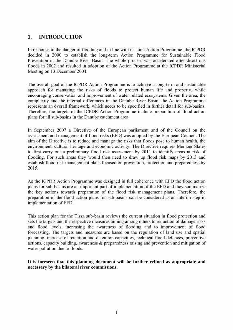
The Tisa River Basin is the largest sub-basin in the Danube River Basin, covering 157,186 km² (19.5%) of the Danube Basin. Together with its tributaries, the Tisa River drains the largest catchment area in the Carpathian Mountains before flowing through the Great Hungarian Plain and joining the Danube River.
1. Figure Orography and river network of the Tisza Basin
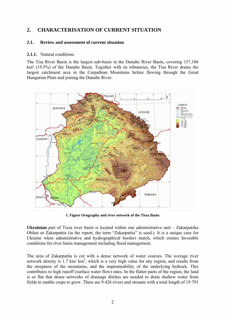
Ukrainian part of Tisza river basin is located within one administrative unit – Zakarpatska Oblast or Zakarpattia (in the report, the term “Zakarpattia” is used.). It is a unique case for Ukraine when administrative and hydrographical borders match, which creates favorable conditions for river basin management including flood management.
The area of Zakarpattia is cut with a dense network of water courses. The average river network density is 1.7 km/ km2, which is a very high value for any region, and results from the steepness of the mountains, and the impermeability of the underlying bedrock. This contributes to high runoff (surface water flow) rates. In the flatter parts of the region, the land is so flat that dense networks of drainage ditches are needed to drain shallow water from fields to enable crops to grow. There are 9 426 rivers and streams with a total length of 19 793
3
km in Zakarpattia. Of these, 153 rivers have an overall length of 3 555 km, and four of them –Tisza, Borzhava, Latorica and Uzh - are each over 100 km long.
2. Figure Ukrainian part of Tisza sub-basin (taken from Tisza basin Analysis, ICPDR, 2007)
The northern and western parts of Romania belong to the Tisza River Basin. Its catchment area on Romanian territory is 70 263 km2 including Tisza and its tributaries Viseu, Iza, Tur, Somes, Crasna, Crisul Alb, Crisul Negru, Crisul Repede, Mures, Aranca, Bega and Bega Veche River Basin.
Upper Tisza forms a natural border with Ukraine with a length of 62.5 km, between Valea Viseului and Teceul Mic localities.
The left side tributaries of the Tisza River are: the Viseu, the Iza, the Tur, the Somes and the Crasna Rivers on the Romanian territory. The Tur, Somes, Crasna, Crisuri and Mures Rivers join the Tisza on the Hungarian territory. The Tisza River Basin includes 11 counties: Cluj, Salaj, Maramures, Satu-Mare, Bihor, Arad, Timis, Hunedoara, Alba, Mures, Bistrita-Nasaud.
The Slovak part of the Tisa River Basin consists of these main river sub-basins:
The northern part of the Bodrog River Basin, in which is the Bodrog River formed by the confluence of the Ondava and the Latorica rivers. The Bodrog River crosses the Slovak-Hungarian border near the village Streda nad Bodrogom in Slovakia and the village Felsőberecki in Hungary,
The northern part of the international Slaná River basin, The northern part of the international Bodva River basin, The northern part of the international Hornád River basin.
4
Salard
Oasa
Tileagd
Fantanele
Lugasu
Ginta
Tamasda
Varsolt
Surduc
Vanatori
Taut
Manastur
Colibita
Calinesti
Dragan
Moftin
BaIauseri
Teliuc
Tarnita
Bezid
Fenes
Zetea
Tau
Lesu
Izvorin
Hateg
Cosdeni
Bacia
Ianova
Murani
Paclisa
Gilau
Hodos
Stramtori
Crestur
Vasad I
StiucilorFelix
Sistarovat
Sannicolau
Mouca
Subcetate
Repas
Les
Satchinez
Ciutelec
RosieniSimbata
Ostrovul Mic
Fughiu
Chier
LivadaAdona
Floresti
Silindru
Petresti
Ighis
Albis I
Uileacul de Munte
Irina
Manic
Fegernic
Deva Mintia
Miersig II
Cenei
Aruncuta
Capalna
Andrid
Scutard I
Giarmata
Tureni
Gepiu I
Carand-Rapsig
Viteilor
Berindan
Diosig I
Brateni
Mihoesti
Carasau
Eger
Iosifalau
Bulz
Cladova
Faneata Vacilor
Salatig
CugirBretea
HodisaPetresti III
Sacuieu
Becheni
Nasal
Medisa
Ocna Mures
Bistrita
InandSantelec
Bercu Nou II
Hitias
Corbeni
Sustra
Dobra
Calacea
Dania
Sai
Cehal I
Sacaseni
Mujdeni
Tiream I
Somesul Rece II
Dobricel
HomorogMunteni
Taul Negru
Lighet
Lunca Spirie
Cucea
Nistru
Salatruc
Petrileni
Secas II
Firiteaz
Raul Mic
Cruscior III
Moldovenesti
Palincarie
Loranta
MadarasÇu
Reghea
Budureasa I
Noroieni
Somesul Rece
Husasau
Iezerul Netis
Mihaileni
Sureanu
Taul Blajoaia
Runcu
Ucuris II
Hodos
Rastolita
Sanandrei
Cosari ICosari II
N
EW
S
3. Figure Romanian part of the Tisza Basin
The southern parts of these river basins are situated in the Hungary. Large watercourses, as well as numerous smaller watercourses are under administration of the Slovak Water Management Enterprise, state enterprise (important watercourses). The other watercourses are administered by the municipalities, forestry, agriculture, army, etc.
The Bodrog River itself is the typical lowland river. Its steep river banks are eroded by the water and also the sedimentation occurs in several stretches. The discharge capacity of the river channel is still opened and disputable, because it is related to the outflow conditions in the whole river basin and also to the measures, which have been or will be realized in the Hungary. In the basins of small rivers and creeks there is an unfavourable situation. The discharge capacity of these watercourses is insufficient in the upper and also upland parts of the Bodrog River basin, where drainage regulations have been realized. There are an almost irreparable damages in the watercourses caused by the self-initiated regulations of several villages, because they never had the adequate discharge capacity and also their realization quality is miserably low.
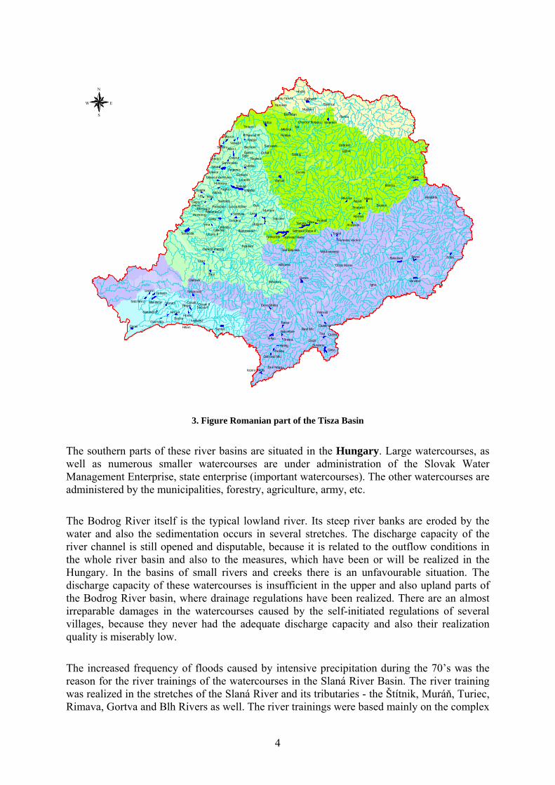
The increased frequency of floods caused by intensive precipitation during the 70’s was the reason for the river trainings of the watercourses in the Slaná River Basin. The river training was realized in the stretches of the Slaná River and its tributaries - the Štítnik, Muráň, Turiec, Rimava, Gortva and Blh Rivers as well. The river trainings were based mainly on the complex
5
river channel regulation and construction of the dykes on both banks either. They protected the towns and villages and also the agricultural land in the valley of the Slaná River. The flood protection permitted the urban development of the settlements and the construction of important transport corridors.
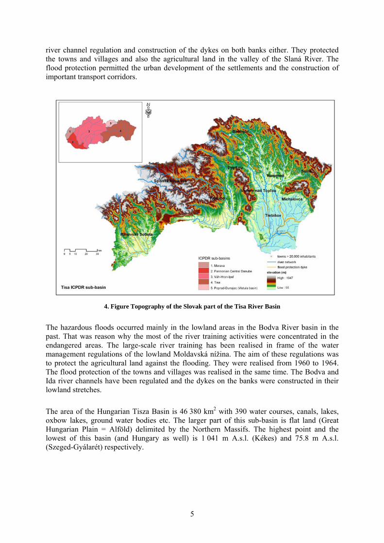
4. Figure Topography of the Slovak part of the Tisa River Basin
The hazardous floods occurred mainly in the lowland areas in the Bodva River basin in the past. That was reason why the most of the river training activities were concentrated in the endangered areas. The large-scale river training has been realised in frame of the water management regulations of the lowland Moldavská nížina. The aim of these regulations was to protect the agricultural land against the flooding. They were realised from 1960 to 1964. The flood protection of the towns and villages was realised in the same time. The Bodva and Ida river channels have been regulated and the dykes on the banks were constructed in their lowland stretches.
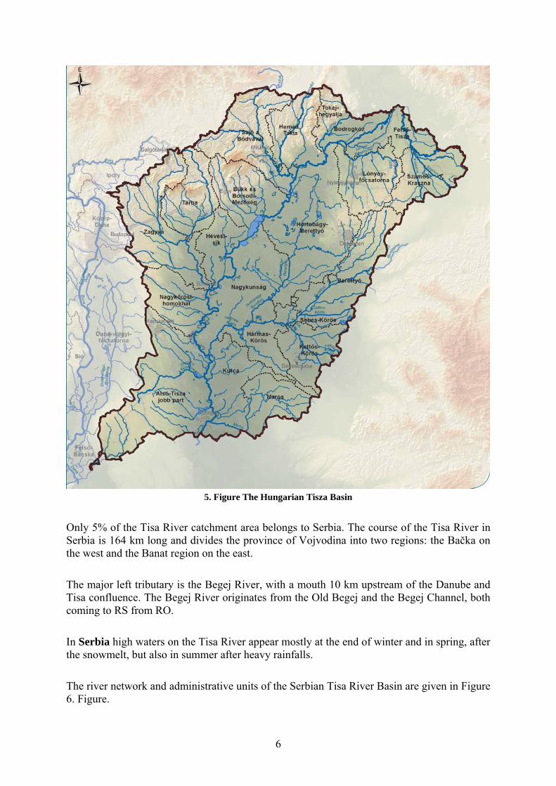
The area of the Hungarian Tisza Basin is 46 380 km2 with 390 water courses, canals, lakes, oxbow lakes, ground water bodies etc. The larger part of this sub-basin is flat land (Great Hungarian Plain = Alföld) delimited by the Northern Massifs. The highest point and the lowest of this basin (and Hungary as well) is 1 041 m A.s.l. (Kékes) and 75.8 m A.s.l. (Szeged-Gyálarét) respectively.
6
5. Figure The Hungarian Tisza Basin
Only 5% of the Tisa River catchment area belongs to Serbia. The course of the Tisa River in Serbia is 164 km long and divides the province of Vojvodina into two regions: the Bačka on the west and the Banat region on the east.
The major left tributary is the Begej River, with a mouth 10 km upstream of the Danube and Tisa confluence. The Begej River originates from the Old Begej and the Begej Channel, both coming to RS from RO.
In Serbia high waters on the Tisa River appear mostly at the end of winter and in spring, after the snowmelt, but also in summer after heavy rainfalls.
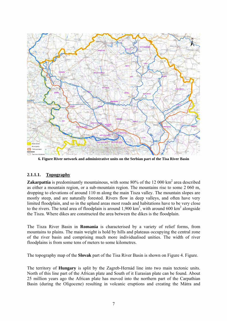
The river network and administrative units of the Serbian Tisa River Basin are given in Figure 6. Figure.
7
6. Figure River network and administrative units on the Serbian part of the Tisa River Basin
2.1.1.1. Topography
Zakarpattia is predominantly mountainous, with some 80% of the 12 000 km2 area described as either a mountain region, or a sub-mountain region. The mountains rise to some 2 060 m, dropping to elevations of around 110 m along the main Tisza valley. The mountain slopes are mostly steep, and are naturally forested. Rivers flow in deep valleys, and often have very limited floodplain, and so in the upland areas most roads and habitations have to be very close to the rivers. The total area of floodplain is around 1,900 km2, with around 600 km2 alongside the Tisza. Where dikes are constructed the area between the dikes is the floodplain.
The Tisza River Basin in Romania is characterised by a variety of relief forms, from mountains to plains. The main weight is hold by hills and plateaus occupying the central zone of the river basin and comprising much more individualised unities. The width of river floodplains is from some tens of meters to some kilometres.
The topography map of the Slovak part of the Tisa River Basin is shown on Figure 4. Figure.
The territory of Hungary is split by the Zagreb-Hernád line into two main tectonic units. North of this line part of the African plate and South of it Eurasian plate can be found. About 25 million years ago the African plate has moved into the northern part of the Carpathian Basin (during the Oligocene) resulting in volcanic eruptions and creating the Mátra and
8
Zemplén Hills. The thickness of the crust is lower than the average in Hungary (26-27 km instead of 33 km) resulting in higher geothermal gradient.
The oldest rocks (900-1 100 million years) can be found on the Alföld. During the Trias the territory of Hungary was under sea creating huge limestone and dolomite deposits (northern part). The slowly subsiding basin was inundated by the Pannonian Sea that covered the region by thousands of meter thick sand and clay layers. With the aggradation of the Pannonian Sea a freshwater swampy lake remained forming lignite, crude oil and natural gas deposits. During the ice age the cold wind storms, exploring the opportunity of lacking vegetation, carried a lot of dust from the river beds that turned into loess layers. Later he river filled up their floodplains resulting in perfect flat regions. Also dune regions were formed in Kiskunság and Nyírség.
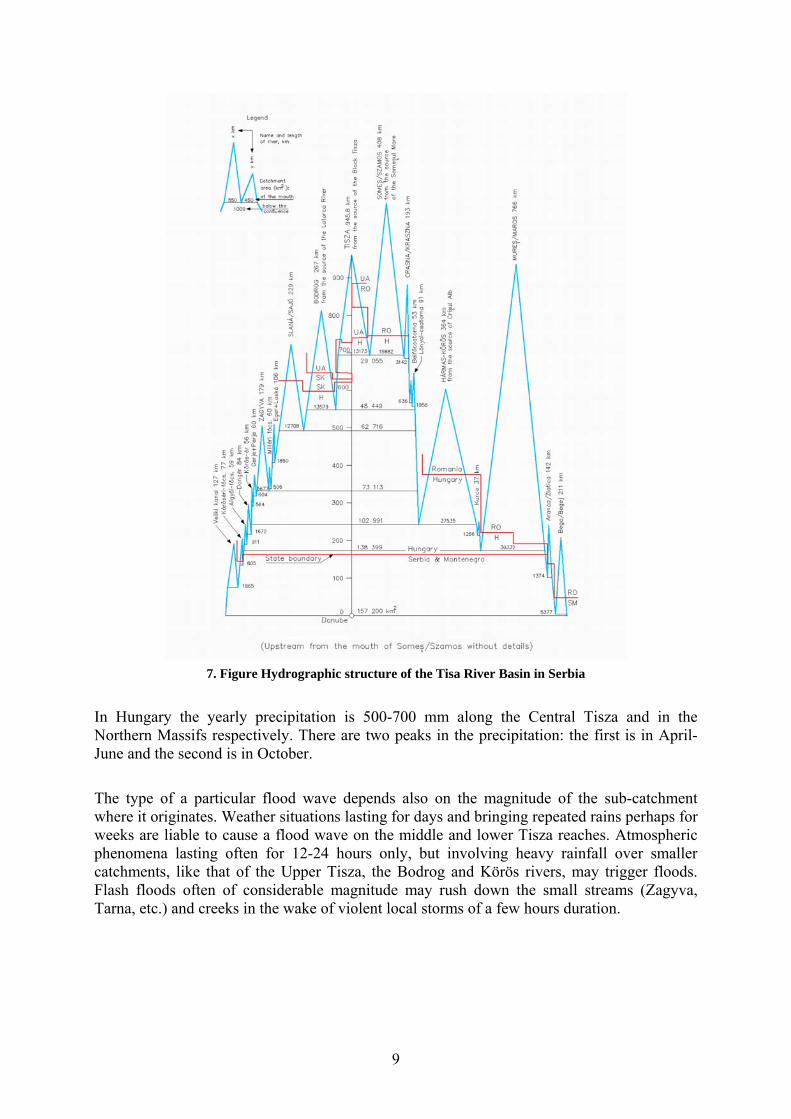
The hydrographic structure of the Tisza Basin is shown on Figure 7. Figure
2.1.1.2. Hydrology
The Upper Tisza river basin has a long history of flooding as a result of intense rainfall episodes. The highest level of rainfall occurs in June and the lowest in January and February. However, the melting of the thick snow cover in spring raises the general level of the rivers and if this combines with high rainfall, a flood wave can (and often does) develop. Within 6 - 10 hours, the water from such an event reaches the Ukraine-Romanian border and within 12 - 36 hours it reaches the Ukraine-Hungarian border, with a possible water level rise of 8-10 m.
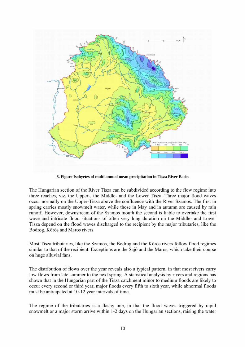
The Tisa River Basin is influenced by the Atlantic, Mediterranean and Continental climates, which impact regional precipitation. About 60% of the Upper Tisza River Basin gets more than 1000 mm of precipitation annually. Warm air masses from the Mediterranean Sea and the Atlantic Ocean cause cyclones with heavy rainfall on the southern and western slopes.
The multi-annual mean values of annual precipitation vary within the Tisza River Basin from 500 to 1600 mm/yr (See Figure 8. Figure). The highest values (around 1,600 mm/yr) occur in the northwestern Carpathians and in the Apuseni Mountains.
The highest maximum depth of snow, measured in various mountains of the Tisa River Basin are above 100 cm, with water equivalents of 250-300 mm. Lower maximum values (40-60 cm with water equivalents of 100-200 mm) were registered in the lowland parts of the basin.
In the mountainous regions, flash floods are common in the spring and summer. These are further intensified by the low infiltration capacity of the soils in the Carpathian Mountains. These floods cause enormous inundation in the lowland areas.
Rainfall in the Carpathian Mountains can be substantial and sudden. Extensive runoff, floodplain deforestation and river canalization reduce the ability of the catchment to attenuate the flood wave. When heavy rains occur, flooding threatens human lives as water levels rise quickly without sufficient retention capacity.
9
7. Figure Hydrographic structure of the Tisa River Basin in Serbia
In Hungary the yearly precipitation is 500-700 mm along the Central Tisza and in the Northern Massifs respectively. There are two peaks in the precipitation: the first is in April-June and the second is in October.
The type of a particular flood wave depends also on the magnitude of the sub-catchment where it originates. Weather situations lasting for days and bringing repeated rains perhaps for weeks are liable to cause a flood wave on the middle and lower Tisza reaches. Atmospheric phenomena lasting often for 12-24 hours only, but involving heavy rainfall over smaller catchments, like that of the Upper Tisza, the Bodrog and Körös rivers, may trigger floods. Flash floods often of considerable magnitude may rush down the small streams (Zagyva, Tarna, etc.) and creeks in the wake of violent local storms of a few hours duration.
10
8. Figure Isohyetes of multi annual mean precipitation in Tisza River Basin
The Hungarian section of the River Tisza can be subdivided according to the flow regime into three reaches, viz. the Upper-, the Middle- and the Lower Tisza. Three major flood waves occur normally on the Upper-Tisza above the confluence with the River Szamos. The first in spring carries mostly snowmelt water, while those in May and in autumn are caused by rain runoff. However, downstream of the Szamos mouth the second is liable to overtake the first wave and intricate flood situations of often very long duration on the Middle- and Lower Tisza depend on the flood waves discharged to the recipient by the major tributaries, like the Bodrog, Körös and Maros rivers.
Most Tisza tributaries, like the Szamos, the Bodrog and the Körös rivers follow flood regimes similar to that of the recipient. Exceptions are the Sajó and the Maros, which take their course on huge alluvial fans.
The distribution of flows over the year reveals also a typical pattern, in that most rivers carry low flows from late summer to the next spring. A statistical analysis by rivers and regions has shown that in the Hungarian part of the Tisza catchment minor to medium floods are likely to occur every second or third year, major floods every fifth to sixth year, while abnormal floods must be anticipated at 10-12 year intervals of time.
The regime of the tributaries is a flashy one, in that the flood waves triggered by rapid snowmelt or a major storm arrive within 1-2 days on the Hungarian sections, raising the water
11
level by several meters within a brief period of time, on some rivers within a few hours only. The Upper Tisza and her tributaries, further the Körös rivers pose an especially high risk in this respect, where 28-36 hours after a rainfall the water level may rise by as much as 8-10 m in the entrance boundary cross section.
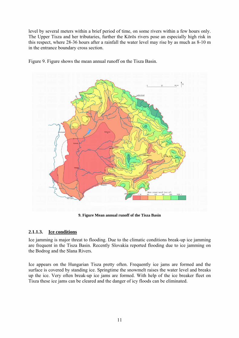
Figure 9. Figure shows the mean annual runoff on the Tisza Basin.
9. Figure Mean annual runoff of the Tisza Basin
2.1.1.3. Ice conditions
Ice jamming is major threat to flooding. Due to the climatic conditions break-up ice jamming are frequent in the Tisza Basin. Recently Slovakia reported flooding due to ice jamming on the Bodrog and the Slana Rivers.
Ice appears on the Hungarian Tisza pretty often. Frequently ice jams are formed and the surface is covered by standing ice. Springtime the snowmelt raises the water level and breaks up the ice. Very often break-up ice jams are formed. With help of the ice breaker fleet on Tisza these ice jams can be cleared and the danger of icy floods can be eliminated.
12
2.1.2. Floodplains and flood defences
At the territory of Zakarpattia, the oldest technical flood defense structures are built at the beginning of XVIII century. There are 824 km of dykes, including 690 km along the main rivers and 134 km – at small rivers and ameliorative channels. River training works are conducted on the area of 82 km. The flood defense system includes water outlet channels of total length 1344 km, where 1107 hydro-technical structures are located. The total length of bank enforcement and riverbed training constructions (embankment walls, gabions etc.) is 274 km. As design criteria 0.5% exceedence probability of the design water level for the structures of “class I” that protect more than 100 000 ha of agricultural lands is used. For the structures of “class IV” that protect the recreational and sanitary area it goes up as high as 10%.
In order to protect goods and human lives, on Romanian territory have been realised hydraulic structures which compose the National System for Flood Defence. The main hydraulic works affecting the flow regime of the rivers are: reservoirs, deviations and water transfers from neighbouring basin into a reservoir and levees. These types of infrastructures are in fact the most useful instruments for water management, offering possibilities in getting regulation of different volumes during the seasons and sometimes during the year, to offer flood protection or dilution in case of accidental pollution.
In Someş-Tisa Basin there are 87 reservoirs with various purposes (water supply, energetic, flood protection, fishery and irigation); 9 derivations of total length of 169.4 km and with an installed discharge of 47.3 m3/s; there also exist 514 river bed regulations of 1005 km length and 136 dykes of 1087 km length total. These works offer protection against floods to: 16 towns, 74 industrial units, 31,000 homes or residences, 144000 ha surface, roads, bridges, railways, etc. The majority of these works are mainly protecting localities, rather than extra-villain terrain. Among the protected localities there are: Cluj–Napoca, Baia Mare, Bistriţa, Zalău, Dej, Beclean, Năsăud and Jibou.
In the Crişuri Basin there are 46 reservoirs with the main purpose of flood protection. There are 5 derivations in total length of 249.1 km and with an installed discharge of 347.5 m3/s too. The 378 regulations of river beds with a total length of 700 km and 218 dikes of total length of 1162 km protect against floods: 29 towns, 138 industrial units, 59,000 houses and residences, a surface of 264,000 ha, roads, bridges, railways and other objects.
In the Mureş Basin there are 127 reservoirs with a total volume of 685 mn.m3 and 7 derivations of total length of 264.0 km and with an installed discharge of 21.2 m3/s. From those 26 reservoirs with a volume over 1 mn.m3, 17 are permanent and 9 are polders. There are also 583 regulations of river beds of a total length of 816 km and 210 dikes of a total length of 827 km. These works protect against floods: 55 towns, 381 industrial units, 69,000 houses, 194,000 ha, roads, bridges, railways, roads and other objects.
In Slovakia a detailed survey of watercourses in towns and villages from the viewpoint of the flood protection has been carried out by the Slovak Water Management Enterprise, in the period from 1999, April to 2002, March. The results of the survey are updated according to the floods occurrence in the individual river sub-basins annually. The results of evaluation are summarized in the Table below.
13
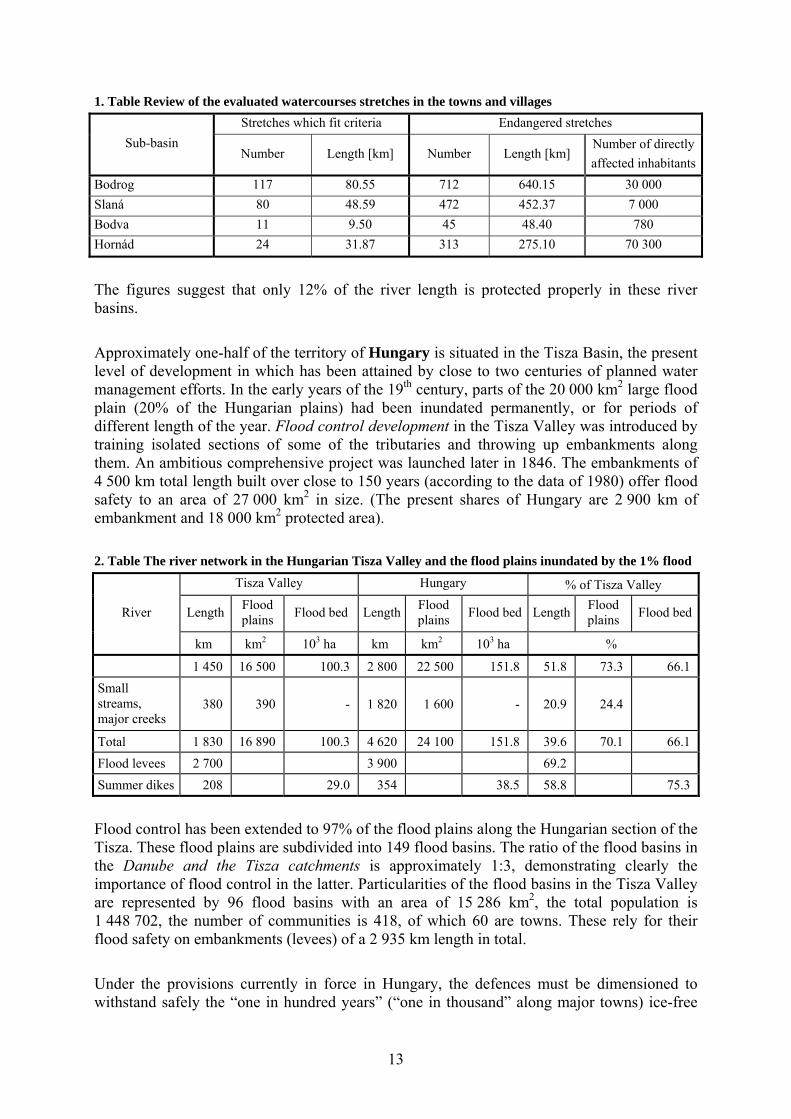
1. Table Review of the evaluated watercourses stretches in the towns and villages
Sub-basin
Stretches which fit criteria Endangered stretches
Number Length [km] Number Length [km] Number of directly
affected inhabitants
Bodrog 117 80.55 712 640.15 30 000
Slaná 80 48.59 472 452.37 7 000
Bodva 11 9.50 45 48.40 780
Hornád 24 31.87 313 275.10 70 300
The figures suggest that only 12% of the river length is protected properly in these river basins.
Approximately one-half of the territory of Hungary is situated in the Tisza Basin, the present level of development in which has been attained by close to two centuries of planned water management efforts. In the early years of the 19th century, parts of the 20 000 km2 large flood plain (20% of the Hungarian plains) had been inundated permanently, or for periods of different length of the year. Flood control development in the Tisza Valley was introduced by training isolated sections of some of the tributaries and throwing up embankments along them. An ambitious comprehensive project was launched later in 1846. The embankments of 4 500 km total length built over close to 150 years (according to the data of 1980) offer flood safety to an area of 27 000 km2 in size. (The present shares of Hungary are 2 900 km of embankment and 18 000 km2 protected area).
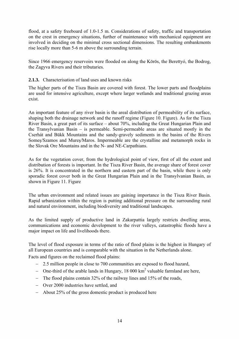
2. Table The river network in the Hungarian Tisza Valley and the flood plains inundated by the 1% flood
River
Tisza Valley Hungary % of Tisza Valley
Length Flood plains
Flood bed LengthFlood plains
Flood bed Length Flood plains
Flood bed
km km2 103 ha km km2 103 ha %
1 450 16 500 100.3 2 800 22 500 151.8 51.8 73.3 66.1
Small streams, major creeks
380 390 - 1 820 1 600 - 20.9 24.4
Total 1 830 16 890 100.3 4 620 24 100 151.8 39.6 70.1 66.1
Flood levees 2 700 3 900 69.2
Summer dikes 208 29.0 354 38.5 58.8 75.3
Flood control has been extended to 97% of the flood plains along the Hungarian section of the Tisza. These flood plains are subdivided into 149 flood basins. The ratio of the flood basins in the Danube and the Tisza catchments is approximately 1:3, demonstrating clearly the importance of flood control in the latter. Particularities of the flood basins in the Tisza Valley are represented by 96 flood basins with an area of 15 286 km2, the total population is 1 448 702, the number of communities is 418, of which 60 are towns. These rely for their flood safety on embankments (levees) of a 2 935 km length in total.
Under the provisions currently in force in Hungary, the defences must be dimensioned to withstand safely the “one in hundred years” (“one in thousand” along major towns) ice-free
14
flood, at a safety freeboard of 1.0-1.5 m. Considerations of safety, traffic and transportation on the crest in emergency situations, further of maintenance with mechanical equipment are involved in deciding on the minimal cross sectional dimensions. The resulting embankments rise locally more than 5-6 m above the surrounding terrain.
Since 1966 emergency reservoirs were flooded on along the Körös, the Berettyó, the Bodrog, the Zagyva Rivers and their tributaries.
2.1.3. Characterisation of land uses and known risks
The higher parts of the Tisza Basin are covered with forest. The lower parts and floodplains are used for intensive agriculture, except where larger wetlands and traditional grazing areas exist.
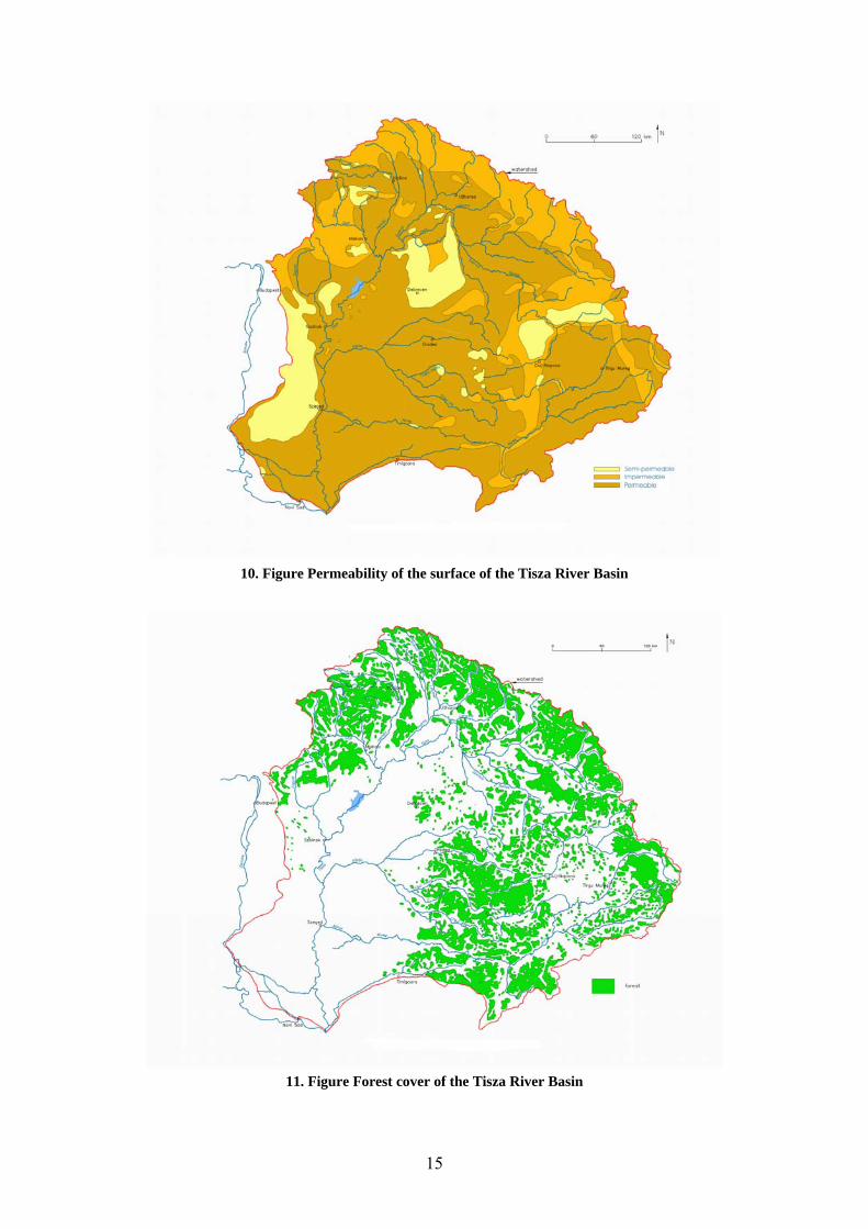
An important feature of any river basin is the areal distribution of permeability of its surface, shaping both the drainage network and the runoff regime (Figure 10. Figure). As for the Tisza River Basin, a great part of its surface – about 70%, including the Great Hungarian Plain and the Transylvanian Basin – is permeable. Semi-permeable areas are situated mostly in the Cserhát and Bükk Mountains and the sandy-gravely sediments in the basins of the Rivers Someş/Szamos and Mureş/Maros. Impermeable are the crystalline and metamorph rocks in the Slovak Ore Mountains and in the N- and NE-Carpathians.
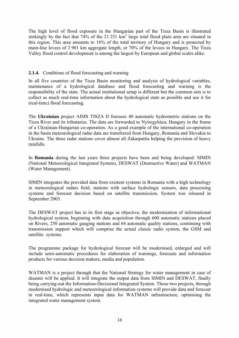
As for the vegetation cover, from the hydrological point of view, first of all the extent and distribution of forests is important. In the Tisza River Basin, the average share of forest cover is 26%. It is concentrated in the northern and eastern part of the basin, while there is only sporadic forest cover both in the Great Hungarian Plain and in the Transylvanian Basin, as shown in Figure 11. Figure
The urban environment and related issues are gaining importance in the Tisza River Basin. Rapid urbanization within the region is putting additional pressure on the surrounding rural and natural environment, including biodiversity and traditional landscapes.
As the limited supply of productive land in Zakarpattia largely restricts dwelling areas, communications and economic development to the river valleys, catastrophic floods have a major impact on life and livelihoods there.
The level of flood exposure in terms of the ratio of flood plains is the highest in Hungary of all European countries and is comparable with the situation in the Netherlands alone.
Facts and figures on the reclaimed flood plains:
2.5 million people in close to 700 communities are exposed to flood hazard,
One-third of the arable lands in Hungary, 18 000 km2 valuable farmland are here,
The flood plains contain 32% of the railway lines and 15% of the roads,
Over 2000 industries have settled, and
About 25% of the gross domestic product is produced here
15
10. Figure Permeability of the surface of the Tisza River Basin
11. Figure Forest cover of the Tisza River Basin
16
The high level of flood exposure in the Hungarian part of the Tisza Basin is illustrated strikingly by the fact that 74% of the 21 251 km2 large total flood plain area are situated in this region. This area amounts to 16% of the total territory of Hungary and is protected by main-line levees of 2 901 km aggregate length, or 70% of the levees in Hungary. The Tisza Valley flood control development is among the largest by European and global scales alike.
2.1.4. Conditions of flood forecasting and warning
In all five countries of the Tisza Basin monitoring and analysis of hydrological variables, maintenance of a hydrological database and flood forecasting and warning is the responsibility of the state. The actual institutional setup is different but the common aim is to collect as much real-time information about the hydrological state as possible and use it for (real-time) flood forecasting.
The Ukrainian project AIMS TISZA II foresees 40 automatic hydrometric stations on the Tisza River and its tributaries. The data are forwarded to Nyíregyháza, Hungary in the frame of a Ukrainian-Hungarian co-operation. As a good example of the international co-operation in the basin meteorological radar data are transferred from Hungary, Romania and Slovakia to Ukraine. The three radar stations cover almost all Zakarpattia helping the prevision of heavy rainfalls.
In Romania during the last years three projects have been and being developed: SIMIN (National Meteorological Integrated System), DESWAT (Destructive Water) and WATMAN (Water Management).
SIMIN integrates the provided data from existent systems in Romania with a high technology in meteorological radars field, stations with surface hydrologic sensors, data processing systems and forecast decision based on satellite transmission. System was released in September 2003.
The DESWAT project has in its first stage as objective, the modernisation of informational hydrological system, beginning with data acquisition through 600 automatic stations placed on Rivers, 250 automatic gauging stations and 64 automatic quality stations, continuing with transmission support which will comprise the actual classic radio system, the GSM and satellite systems.
The programme package for hydrological forecast will be modernised, enlarged and will include semi-automatic procedures for elaboration of warnings, forecasts and information products for various decision makers, media and population.
WATMAN is a project through that the National Strategy for water management in case of disaster will be applied. It will integrate the output data from SIMIN and DESWAT, finally being carrying-out the Information-Decisional Integrated System. Those two projects, through modernised hydrologic and meteorological information systems will provide data and forecast in real-time, which represents input data for WATMAN infrastructure, optimising the integrated water management system.
17
17 synoptic stations are operated in the Hungarian part of the Tisza drainage basin, beside standard 3-hourly observations; 1-hourly observations are also reported. There are 31 reporting „climate” stations sending 12-hourly or daily reports, 56 hydro-meteorological stations operated by district water authorities may add the above set of information in the period of floods.
Two meteorological radars cover the Tisza Basin Budapest and Nyíregyháza-Napkor supplementing land based precipitation measurements. Around 30 telemetry rain gauges are in operation at the end of 2001 enabling calibration of radar measurements.
There are 87 reporting water level gauges on the Hungarian section of Tisza and tributaries. The usual pattern of observation follows daily twice observations but only daily reporting. Over 40 gauges report more frequently to regional centres as equipped with recording and telemetry equipment. All the station report more frequently during flood alert: 2-hourly or 1-hourly. During flood periods special gauge readings are also reported, the number of special flood gauges totals 240.
The National Meteorological Service generates meteorological warnings. These warnings reach Regional Environmental and Water Directorates (KÖVIZIGs) by means of VIR via the Central Water and Environmental Directorate (VKKI) Preparedness Unit or the National Hydrological Forecasting Service (NHFS-VITUKI) or directly. Generation of hydrological warnings is the primary responsibility of district water authorities however any agency (NHFS etc.) receiving information indicating the necessity of flood warning or flood alert should act with no time delay.
Regular (daily) hydrological forecast for River Tisza and main tributaries (46 gauging stations) are issued by NHFS-VITUKI. The conceptual modularly structured GAPI/TAPI modelling system is in use containing rainfall- runoff (with snow accumulation and ablation, soil frost sub-modules); channel routing; statistical updating; and simplified hydraulic - backwater modules. Forecasting of flood crests is the responsibility of the agency named by Rules of Hydrometeorological Activity during floods - VKKI Directive. As a principle the territorially competent water authority is named as responsible.Results of European Flood Alert System (EFAS) are also incorporated into the daily operation of the NHFS-VITUKI.
Republic Hydrometeorological Service of Serbia is charged to monitor, measure, collect and analyze hydrologic and meteorological data. The Service is also providing relevant information and forecast from domestic and foreign territories to all the flood defence 5 participants. Data are collected on 8 gauges on the Serbian part of the Tisa river basin, as well from 25 foreign gauges (Hungary and Romania).
2.1.5. Recent awareness of flooding
In Ukraine the severity, frequency and economic impact of flood events have shown an increasing trend since the late 1960s. Thus, very large floods have occurred in May 1970, December 1993, November 1998 and the largest of all in March 2001. July 2008 flood was the largest, but not for the whole Tisza, but downstream Viseu (right side tributary of Tisza in Romania).
18
Due to the high torrential degree of watercourses, to the climatic conditions, physical and geographical factors flooding on Romanian territory is a frequent phenomenon.
In the last years the occurrence of flooding was higher. In 2005, 2006 and 2008, dangerous, atypical hydrological and meteorological phenomena took place with human lives and huge material losses.
In 2005 the total value of material damages, due to the flooding in Timiş, Olt, Siret and Ialomiţa hydrographical basins was app. 1.66 bn. EURO, representing 0.6% of national GDP. The registered high-flood on Romanian sector of the Danube in April 2006 was the highest since 1898. The consequences were that dikes failed on many sectors. In July 2008, historical values of water discharge and levels have been registered in Tisa, Siret and Prut basins.
Large historical floods in the Slovak part of the Tisa river basins occurred in 1646, 1772, 1813, 1816, 1817 and 1888. Flood at the level of approximately Q100 affected territory in 1924. Significant floods in the second half of the XXth century, after realization of complex flood protection, drainage and river training works date back to 1967, 1974, 1979, 1980, 1989 and 1992. According to the reports of the SWME, the most recent period was evaluated, too. It covers incomplete twelve years (1997-2008), twice as long period as the six years period specified for the reviewing and updating of the preliminary flood risk assessment by the Directive 2000/60/EC of European Parliament and Council on the assessment and management of flood risks. It reports 19 flooding events, of them 5 flash floods, 8 caused by intensive rainfall, 4 combined snowmelt and rainfall and 2 ice jam flooding. The most severe one was the July 1998 Hornád River flood with more than 50 casualties, more than 60 municipalities heavily affected
On the territory of Hungary the greatest floods registered over the past one-hundred years, the one in 1879 was a spring flood the other in 1888 was fed by winter precipitation the one 1895 was caused by the melting snow cover, while that in 1919 originated from spring rainfall. The 1932 flood, caused by the flood discharge of the tributary Maros, was backed up to especially high levels along the Middle- and the Lower Tisza. Coinciding and superimposing disastrous floods on the main stream and all tributaries in 1970 resulted in the highest water levels among the spring floods. The ice-jam flood of 1985 on the Upper Tisza reach was unique among the Tisza floods on record.
Following a relatively dry decade, a succession of abnormal floods have set annually new record water levels on several gauges over the last four years. Over a hardly 28 months long period between November 1998, and March 2001, four flood waves have travelled down the Tisza River. Large areas were inundated simultaneously by undrained runoff and flash floods of abnormal height on several minor streams.
Recently the 2006 flood created an unexpected situation when the flood discharge of the Tisza River was not particularly high but the simultaneous large flood of the Danube River backed up the Tisza creating critical situation along the Lower (Hungarian and Serbian) Tisza.
In XXth century, many major floods occurred on the Serbian part of the Tisa River (1919, 1924, 1932, 1940, 1944, 1947, 1965 and 1970), but the protection system endured. The first
19
important flood after the major reconstruction of the levees was in 2000, also without any consequences. The most recent flood on the Tisa River occurred in 2006, almost simultaneously with the Danube flood. Water levels on the most downstream section of the Tisa River were very high, due to the influence of the Danube backwater. The flood protection unit, citizens and the Army made extreme efforts to prevent overtopping of the right levee, and levee breaching on a few week points.
2.2. Review and assessment of the predictable long term developments
At present there is no flood action plan, covering the territory of Ukraine as well as no one joint legislative act concerning flood issues. Nevertheless, there are several national programs, including:
Complex Flood Protection Program in the Tisza river basin in Zakarpattia oblast on 2002-2006 and forecast until 2015 (2001)
National Program on Dnipro Basin Environmental Rehabilitation (1997)
Complex program of prevention of hazardous impact of floods on agriculture and rural settlements (2000)
State program of impoundment prevention and management in Ukraine (2004).
In 1998 and 2001 catastrophic floods occurred in Zakarpattia and done significant damage to property and people.
As a response, the State Water Committee developed “Complex Flood Protection Scheme in the Tisza river basin in Zakarpattia”. It also developed the corresponding “Complex Flood Protection Program in the Tisza river basin in Zakarpattia oblast on 2002-2006 and forecast until 2015” to realize flood protection measures provided by the Scheme. This Program was revised in 2005 and is planned for the period 2006-2015.
The basic approaches used in the Program include:
Construction of new flood protection structures, mainly accumulative dry polders and dry flood protection reservoirs in upper part of Tisza;
Reconstruction of existing hydrotechnical structures and their maintenance;
Construction and reconstruction of railway and road bridges, retaining walls and other railway engineering structures, crossings and culverts on the roads and railway;
Prohibition to build houses and industrial objects in the flood prone zones;
Improvement of the qualitative and quantitative monitoring of water resources;
Introduction of environmentally safe technologies in water management, agriculture and forestry following requirements of Water, Agriculture and Forest Codes of Ukraine and other legal regulation.
Taking into account the significance of the Program, it has some drawbacks:
It focuses mainly on construction measures,
It does not reflect climate change
It does not fully fit with requirements of EU Flood Directive 2007, although it reflects some of them (development of flood hazard and flood risk maps).
20
During the first years of the Program’s implementation it was under-financed, but last three years (2006-2008) it was financed according to its budget. Taking into account economic crisis, happened from the autumn 2008, it is easy to foresee that in 2009 minimum the Program will be not be financed fully.
The National Plan for Prevention and Flood Protection is part of the Romanian national politics and constitutes a necessary tool for national coordination and basin correlation of investments in water management domain. The National Strategy for Flood Risk Management on short term adopted in December 2005 takes into consideration the following aspects and priorities:
preliminary estimation;
critical analysis of existing flood defences;
basic principles for national strategy for flood risk management on medium and long term;
risk reduction means both vulnerability and objective factors mitigation;
both structural an non-structural measures are necessary;
we should take into consideration all local and regional conditions;
European context: directives, funds.
The existing legislative framework offer to the central authorities and public local administration the legal support for the prevention, protection and preparation activities in flood risk management (Regulations regarding flood adopted in 2005)
In Hungary the sequence of improvement of flood risk management along the remaining flood basins has been determined with the following principles and considerations in mind:
The specified crest elevation and cross-sectional dimensions of the levees,
The structural properties of the embankments,
The phenomena observed during flood exposure and the assessment thereof,
The population and the number of communities protected,
The magnitude of the potential losses, and
The possibilities of flood confinement.
Following extensive studies, the Ministry of Transport and Water has submitted eventually – as the first stage – a proposal for the improvement of embankments of 740 km total length, which the Government has approved by the Order No. 2003/2002 (I.11) with an implementation period of 5 years.
During the 1998 to 2000 period four abnormal flood waves have passed down the River Tisza. The total costs of flood fighting, emergency measures and reconstruction have amounted to some HUF 120 billion (thousand million). Both public awareness of the hazard potential and the demand for a higher level of safety have grown in the wake thereof.
21
The government, at its special meeting on the 26th of February, 2003, at Szolnok, had approved of the conceptual plan of enhancing flood safety in the Tisza Valley. The development proposal – also known as the “Renewal of Vásárhelyi Plan” - comprises a complex program, which covers beyond the creation of a higher level of flood safety, the improvement of the living standards of the rural- and urban population in the region, the formulation and introduction of new types of agro-ecological land use in the area of the emergency flood retention reservoirs and the modernisation of the infrastructure in the settlements along the River Tisza.
In Stage I, which covers the years 2004 to 2007, the proposed flood safety enhancement measures include the restoration of the flow conveying capacity of the flood bed, the conservation oriented revitalisation thereof along the Tivadar section of the river, as well as along that between Szolnok town and the southern national boundary. Work will also be started on the emergency retention reservoirs, of which six are contemplated at strategic sites.
Agreement has been reached on the principles according to which
the reservoir sites are selected and their area secured,
the compensation to the farmers is awarded when they make available their fields temporarily for the purpose of flood storage, and
the methods of subsequent farming are decided upon.
The costs of the first four years have been estimated at HUF 130 billion, one-half thereof devoted to flood control measures, the other to rural development, agro-ecological farming and infrastructure modernisation projects.
Parallel to the implementation of the Stage I of the program, the scientific and professional foundations of the subsequent Stage II was prepared by the middle of 2005.
After joining the European Union in May 2004 the programme had to be redesigned to match the new financing instruments of the EU. This new programme includes
strengthening of the existing dykes to meet the present design standard (1:100 year flood with 1 m freeboard)
restoring the flood conveyance capacity of the flood way by opening a 300-600 m wide “hydraulic corridor” (an area with less hydraulic resistance)
relocating dykes to remove bottlenecks and
building flood retention reservoirs to provide extra safety against flood larger than the design flood.
Today two of the first six flood retention reservoirs (Cigánd and Tiszaroff Flood Retention Reservoirs) and the dyke relocation at Rákóczifalva have been completed.
The regime of Tisa floods is determined upstream of Serbian territory. Therefore, the most significant impacts on safety of flood defence system along the Tisa River in Serbia are:
22
Trend of flood level increase (due to natural or anthropogenic factors). Under the influence of new structures or works in the Tisa River basin, characteristics of design flood could be changed, lessening the level of flood protection on Serbian territory.
Ill-timed coincidence of flood waves on the Tisa River (HU) and the Moris River (RO) due to the interventions upstream.
Climate change.
After the 2006 flood on the Tisza River the reconstruction of right-bank levees along the Tisa has been started. The reconstruction of the most downstream 15 km long section is almost finished, and only 3 km are planned for 2009.
Further to the structural measure mentioned above non-structural measures are planned too:
The RS-HU and RS-RO bilateral commissions are planning measures to prevent/limit flood hazards, and to eliminate/reduce the consequences.
The project between the Swedish Rescue Services Agency (SRSA) and the Serbian Directorate for Water: “Development of a first draft Flood Risk Management Plan for Tamnava River Basin, Serbia”. Through the implementation of the Flood Directive, this project will strengthen the capacity of the Serbian institutions in charge of flood defence. Insight in project results and their practical implementation will broaden other stakeholders’ knowledge related to flood risk.
EU funded project “Preparation of a Water Management Information System for the Republic of Serbia” (WMIS - EuropeAid/121208/D/SV/YU - Project N° 05SER01/05/004) is presently in a final phase. This project will provide efficient tools for managing the information and data and support water management activities on a country-wide basis.
3. TARGET SETTINGS
Ukraine set the targets for Tisza basin flood protection in the “Complex Flood Protection Program in the Tisza river basin in Zakarpattia oblast on 2002-2006 and forecast until 2015” as follows:
To create safe conditions for human settlements and industry operation in Upper Tisza;
To improve hydrological regime of rivers and ponds;
To ensure surface water run-off regulation in order to optimize water discharge during flood events;
To provide effective spatial use of agricultural lands, cities and other settlements;
To minimize possible losses from floods.
This Program was revised in 2005 and is planned for the period 2006-2015 (See Table below).
3. Table Main directions of the Ukrainian Program implementation
Stages Years Actions
23
1 2006-2015 identification of flood zones of different probability based on modern technologies of hydrological investigations, geodesic and mathematical calculations;
reconstruction and construction of the new dikes
river bank enforcement
riverbed training and other actions
2 2006-2015 construction of accumulative dry polders in the plain part of the region;
3 2008-2015 construction of dry flood protection reservoirs in the mountainous part of the region.
The Romanian Action Plan for flood protection on medium-term (2009-2012) launched and comprises new hydraulic structures in frequently affected zones, higher safety degree of existing works and finalization of ongoing ones. The Action Plan foresees 1850 km River regulation 976 km of dikes, 810 km Riverbank consolidation, finalization of two wetlands in Crişul Negru hydrographic basin and identification of new zones as wetlands and DESWAT and WATMAN Projects finalisation.
The prioritisation criteria for promoting investments for flood protection have been made following:
Inclusion of the proposed works in the Strategy of Ministry of Environment;
Actual safety degree of the flood protection structures;
Amplitude of avoided damages as result of the projects;
The elaboration status of technical and economic documents;
Financing possibility
Occupied field status.
The Slovakian measures for mitigating of adverse impacts of floods for human life and health, the environment, economic activities, cultural and historical heritage result from the sources of menace and conditions in the given endangered localities. It is impossible to find universal solutions and measures valid everywhere, because they have to respect at least:
Sources and courses of floods;
Nature of runoff conditions in the individual watersheds;
Natural conditions in endangered territories;
Charges of the flood protection measures and their comparison to the value of protected properties.
The “Renewal of Vásárhelyi Plan” in Hungary defines the following targets:
Provide protection against 1:100 year floods for the floodplains of the Tisza River by
= strengthening the existing dykes to withstand the design flood and
= restoring the former conveyance capacity of the flood bed,
Reduce the level of 1:1000 year flood by about 1 m by
= giving “more room to river” (construction of regulated dry flood retention reservoirs),
Provide opportunities to nature development and land use change by
= creating (restoring) wetlands
24
= providing “irrigation” water on the polders during smaller floods,
= creating technical background for better water management on the polders by construction of water distribution system.
Implementing criteria from the Water Management Master Plan of the Republic of Serbia, and taking into account the actual flood protection conditions and problems (especially the size of flood prone areas and possible damages) the long term flood protection strategy in the Tisa River basin in Serbia will comprise of:
The existing layout of flood protection structures remains the same, while the following is planned:
= - Regular maintenance of the flood protection structures, according to criteria, standards and norms;
= - Reconstruction or/and construction of the flood protection structures to decrease flood hazard.
Gradual and broad implementation of non-structural flood protection measures (as upgrade of the flood forecasting and warning procedures; introduction of flood maps into spatial plans, etc.).
International cooperation in flood management on rivers which cross the state borders with Hungary and Romania.
3.1. Regulation of land use and spatial planning
All five countries consider land use and spatial planning as a crucial point in flood risk management. Flood risk mapping is on top of the agenda. The flood risk maps are than have to be reflected in the spatial planning and construction licences. Limitations on regularly or potentially flooded regions are to be set.
The following section shows the individual targets set by the countries. Although there are similarities the original text written by each country is retained to better reflect the actions in the next Chapter.
3.1.1. Targets set by Ukraine
Regulations on land use and spatial planning include the following directions:
establishment of protective strips along the banks of watercourses as required by Water Code (Art. 88) and the Land Code (Chapter 13);
resettlement of people from flood prone zones, which cannot be protected by technical flood defenses;
prohibition to construct houses and industrial sites in flood prone zones;
renaturalization of lands by means of reconnection of former floodplain;
development of flood hazard and flood risk maps, as required by EU Flood Directive;
introduction of environmentally friendly technologies of water and land use;
further development of amelioration channel work.
25
3.1.2. Targets set by Romania
The existing local urban plans for development should contain maps with actually flooded areas, based on historic and studies data. These maps are from the Local Flood Protection Plans and are updated every 4 years.
3.1.3. Targets set by Slovakia
Landscape development plans and spatial plans contain and respect flood hazard maps and flood risk maps.
Limitations related to land use in flood prone areas are defined.
3.1.4. Targets set by Hungary
Transposition of the EU Floods Directive into the Hungarian Water Act
Preparation of flood risk maps
Preparation of flood risk management plans
3.1.5. Targets set by Serbia
Spatial plans of municipalities contain flood hazard maps (both for potentially and actually flooded areas) and flood risk maps.
Limitations related to land use in flood prone areas are defined.
3.2. Reactivation of former, or creation of new, retention capacities
To reduce runoff each country in the Tisza Basin considers some kind of actions to hold the water on their territory for a longer time than present. Wetlands, dry reservoirs and polders are the tools in consideration. The complex utilisation of reservoirs (energy production, irrigation, flood risk management etc.) is a less preferred solution though some nature development, wetland construction and water management options in the polders make the picture more divers.
3.2.1. Targets set by Ukraine
Reactivation of former floodplain by construction of polders in plain part of Tisza river basin;
Creation of retention capacity by construction of dry flood protection reservoirs in the mountainous part of the river basin.
3.2.2. Targets set by Romania
Construction/restoration of two wetlands has been considered (in Crişul Negru Basin near to Sudrigiu and Tinca localities). Feasibility studies of them have been prepared.
3.2.3. Targets set by Slovakia
Water in every sub-basin is detained as long as possible - realization of non-structural measures within whole sub-basins in the forested and agricultural lands either.
Provision of suitable tools for the retention of the water - water management reservoirs and polders.
26
Provision of adequate space for flood waves routing in settled areas especially.
3.2.4. Targets set by Hungary
Reactivation of former retention capacities by building flood retention reservoirs along the Tisza River;
Maintenance of existing retention capacities along the tributaries of Tisza River.
3.2.5. Targets set by Serbia
Retention capacities along the Tisa are re-considered.
3.3. Structural flood defences
There is a fairly large flood protection infrastructure in the Tisza Basin. The construction of it has started almost 200 years ago. The maintenance and the reconstruction of it is high on the agenda of the Tisza Basin countries. New protective structures are also considered mainly in the upper parts of the Basin. Erosion control is also a topic of the mountainous regions.
3.3.1. Targets set by Ukraine
Traditionally technical flood defenses planned by the Program include continuation of:
reconstruction and construction of the new dikes
river bank enforcement
riverbed training
construction of dams.
Besides it is envisaged to reconstruct railway and auto transport bridges, erosion prevention actions.
3.3.2. Targets set by Romania
The Action Plan (2009-2012) foresees 1850 km river regulation 976 km of dikes, 810 km riverbank consolidation (for the whole Romanian territory including the Tisza Basin as well). Feasibility studies have been prepared for all investments works.
3.3.3. Targets set by Slovakia
The targets in the field of structural flood protections measures can be defined as follows:
Maintenance of existing retention volumes (removal of sediments) in reservoirs and polders.
Design and construction of reservoirs with flood retention volume and polders.
River training works in urban areas and rural municipalities.
Reconstruction of the trained stretches in the towns and villages in order to achieve sufficient discharge capacity.
Removal of obstacles in the channels, like bridges of insufficient flow capacity, improperly designed culverts and other barriers.
Realization of ordinary maintenance in trained river stretches.
27
Design and construction of measures to decrease erosion and to increase water retention in the river basins (trenches, ditches, canals, etc.)
Torrents regulation in the mountainous areas.
3.3.4. Targets set by Hungary
Improvement of present flood protection structures to meet the existing safety standards
Removing bottlenecks
3.3.5. Targets set by Serbia
Provide protection for the adopted design 100-year flood along the Tisa River. This is an adequate criterion for the protection of the Tisa riparian lands, considering the size of the potentially endangered areas, number of inhabitants and infrastructure value.
Provide permanent preparedness of the flood defence system.
3.4. Non-structural measures (preventive actions, capacity building of professionals, raising awareness and preparedness of general public)
The non-structural measures are effective tools to reduce flood risk. The Tisza Basin countries use this tool to complement the structural interventions.
3.4.1. Targets set by Ukraine
Prevention actions are aimed at improvement of the level of knowledge about flood events, their prognosis and regulations in complex Carpathian ecosystem in conditions of climate change. The following measures are envisaged here:
Fundamental and applied researches of floods, torrents, erosion and other events, human impact at their development, preventative actions to be taken and adaptation measures;
Scientific grounding of flood protection actions at regional and local levels;
Use of the best available techniques for modeling, construction and maintenance of flood protection structures taking into account national and international experience;
Development of methodology of riverbed regulation in Carpathians;
Development of new models of banks enforcement and dikes;
Scientific grounding of dry flood protection reservoirs and dry polders.
It also includes the measures related to:
Improvement of monitoring networks and establishment of integrated environmental assessment
Further metrological and hydrological researches;
Establishment of databases based on GIS and space images;
Improvement of weather forecast, water level and flood prone zones modeling, and further improvement of early warning system, namely AIMS TISZA II.
28
identification of flood zones of different probability based on modern technologies of hydrological investigations, geodesic and mathematical calculations, which goes in line with EU Flood Directive.
Capacity building of professionals includes the following actions:
proficiency courses for water management specialists, including intercalibration exercises;
further improvement of co-ordination between different authorities in case of floods;
improvement of technical capacities of the professionals, namely hardware and software purchasing.
Raising awareness and preparedness of the general public include:
Dissemination of the information concerning actions during the floods among population in flood prone zones;
Publications of informational materials;
Development of Internet based real time sources;
Development of storage places for goods and equipment.
3.4.2. Targets set by Romania
These actions are concentrated towards prevention/mitigation of potential damages generated by floods through:
avoiding houses, social and cultural or/and economic objectives constructions in potentially flooded area;
realisation of structural and non-structural measures for protection;
geographical delimitation of natural flood risk zones and noting these in the general urban planning studies;
modern forecast, warning and alarming systems implementation in case of floods;
existing infrastructure for flood protection and Riverbed maintenance;
effective communication and people education regarding flood risk and the action ways in emergency situations.
financial insurance for flood risk (On 1 January 2010, a law referring to the obligatory insurance for houses against natural disasters such earthquakes, landslides and flooding will come into force).
Raising awareness and preparedness of general public:
Improvement reaction capacity, response and intervention;
Information and awareness of the population regarding floods and its effects;
Eco-centres setting-up in frequently affected zones;
Public meeting presenting the local flood protection plans and the warning procedures based on colours code;
Exercises for flood simulation at basin and county level with the participation of population.
Capacity building of professionals:
An intensive programme for raising personnel capacity of the water management units of Romanian Waters responsible for the maintenance and operation of flood defences has been planned.
29
A training action of new elected mayors and public local administration is being developed.
3.4.3. Targets set by Slovakia
Non-structural measures play important role in the flood risk assessment and management. Targets in this field can be specified as follows:
Reduce flood risk
Introduce principles of EU flood directive
Build capacity of professionals and institutions responsible for flood management
Upgrade flood monitoring, forecasting and warning services
Introduce regulations for emergency situations response
Prepare flood risk management plans
Improve awareness of stakeholders on floods
Update/build scientific base for flood management
Improve international cooperation in flood management
Improve information system on floods and flood risk management accessible to public
3.4.4. Targets set by Hungary
Improvement of flood forecasting system
Improvement of flood warning system
Capacity building of professional staff
Increase PR activity to raise awareness of general public
3.4.5. Targets set by Serbia
The non-structural measures (encompassing institutional, preventive, corrective and other measures) should be given an appropriate role in flood control and mitigation. Main activities should be tied to:
• Preventive and operative tasks (setting up or improving the data base on natural events and protection system characteristics, modification of the existing plans for flood coping practices, adoption of reservoir operational rules, development/improvement of flood forecast and warning system);
• Regulative and institutional measures (zoning of floodplains, floodplain management policy, construction standards etc.);
• Managerial and technical education, as well as public awareness building.
All these tasks will be tied together within the Flood risk management plan for the Tisa River
basin.
Reduce flood risk
Introduce principles of EU flood directive
Build capacity of professionals and institutions responsible for flood management
Upgrade flood monitoring, forecast and warning
30
Introduce regulations for emergency situations response (natural disasters)
Prepare Flood risk management plan
Improve awareness of stakeholders on floods
Update/build scientific base for flood management
Improve international cooperation in flood management
3.5. Prevention and Mitigation of Water Pollution Due to Floods
Water pollution due to flooding is considered a threat to nature in two of the five countries.
3.5.1. Targets set by Ukraine
Prevention and Mitigation of Water Pollution actions include:
Inventory of industrial and agricultural objects on flood prone zones with potential impact of water quality
Development of pollution prevention plan for industrial sites
Water quality control in surface water bodies.
Prevention and Mitigation of Water Pollution actions include:
- Inventory of industrial and agricultural objects on flood prone zones with potential impact of water quality
- Development of pollution prevention plan for industrial sites - Water quality control in surface water bodies.
3.5.2. Targets set by Romania
Characteristic pollutions of the mountainous rivers are heavy metals, especially in Săsar, Crişul Negru, Crişul Alb and Arieş River basins, where there are important mining perimeters with rocks which reach the surface and which are washed by the precipitation. Another significant pressure is represented by the suspended solid loads caused by coal mining activities, especially on Jiu River.
- The Law 466 (regarding dam safety) covers the safety problems of dams and dikes of the mining waste deposits. Now, according to the EU Directive 1999/31/CE and Governmental Decision 349 from 2005 the major part of the mining ponds with high risk stopped the activity. The actual legislation foresees the continuous monitoring of the closed ponds.
31
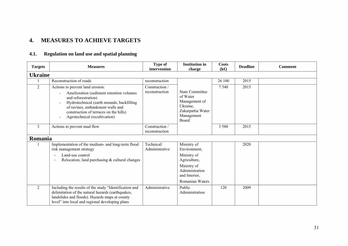
4. MEASURES TO ACHIEVE TARGETS
4.1. Regulation on land use and spatial planning
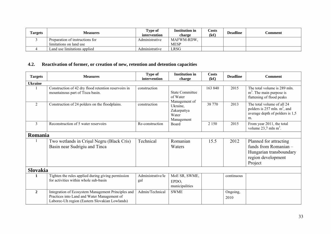
Targets Measures Type of
intervention Institution in
charge Costs (k€)
Deadline Comment
Ukraine 1 Reconstruction of roads reconstruction
State Committee of Water Management of Ukraine, Zakarpattia Water Management Board
26 100 2015
2 Actions to prevent land erosion:
- Amelioration (sediment retention volumes and reforestration)
- Hydrotechnical (earth mounds, backfilling of ravines, embankment walls and construction of terraces on the hills)
- Agrotechnical (recultivation)
Construction / reconstruction
7 540 2015
3 Actions to prevent mud flow Construction / reconstruction
3 580 2015
Romania 1 Implementation of the medium- and long-term flood
risk management strategy
- Land-use control - Relocation, land purchasing & cultural changes
Technical/ Administrative
Ministry of Environment,
Ministry of Agriculture,
Ministry of Administration and Interior,
Romanian Waters
2020
2 Including the results of the study “Identification and delimitation of the natural hazards (earthquakes, landslides and floods). Hazards maps at county level” into local and regional developing plans
Administrative Public Administration
120 2009
32
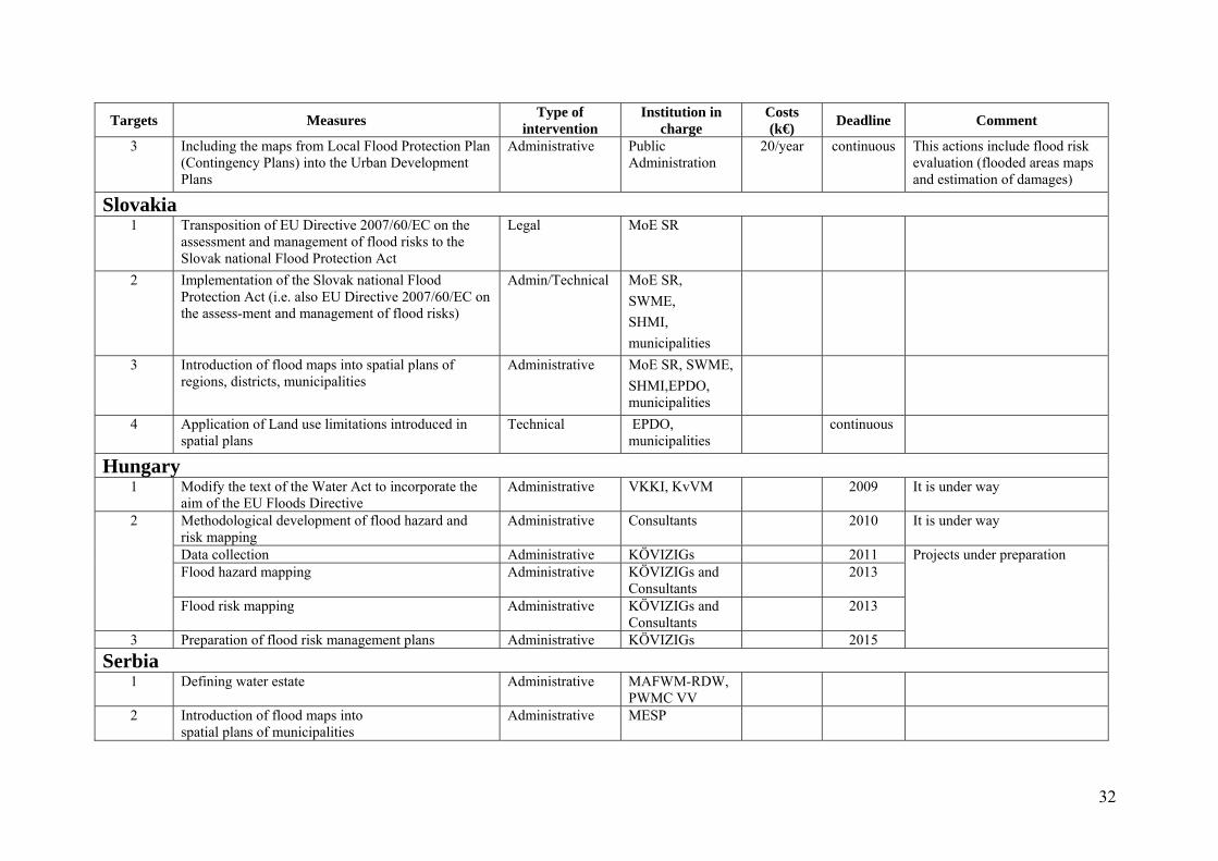
Targets Measures Type of
intervention Institution in
charge Costs (k€)
Deadline Comment
3 Including the maps from Local Flood Protection Plan (Contingency Plans) into the Urban Development Plans
Administrative Public Administration
20/year continuous This actions include flood risk evaluation (flooded areas maps and estimation of damages)
Slovakia 1 Transposition of EU Directive 2007/60/EC on the
assessment and management of flood risks to the Slovak national Flood Protection Act
Legal MoE SR
2 Implementation of the Slovak national Flood Protection Act (i.e. also EU Directive 2007/60/EC on the assess-ment and management of flood risks)
Admin/Technical MoE SR,
SWME,
SHMI,
municipalities
3 Introduction of flood maps into spatial plans of regions, districts, municipalities
Administrative MoE SR, SWME,
SHMI,EPDO, municipalities
4 Application of Land use limitations introduced in spatial plans
Technical EPDO, municipalities
continuous
Hungary 1 Modify the text of the Water Act to incorporate the
aim of the EU Floods Directive Administrative VKKI, KvVM 2009 It is under way
2 Methodological development of flood hazard and risk mapping
Administrative Consultants 2010 It is under way
Data collection Administrative KÖVIZIGs 2011 Projects under preparation Flood hazard mapping Administrative KÖVIZIGs and
Consultants 2013
Flood risk mapping Administrative KÖVIZIGs and Consultants
2013
3 Preparation of flood risk management plans Administrative KÖVIZIGs 2015
Serbia 1 Defining water estate Administrative MAFWM-RDW,
PWMC VV
2 Introduction of flood maps into spatial plans of municipalities
Administrative MESP
33
Targets Measures Type of
intervention Institution in
charge Costs (k€)
Deadline Comment
3 Preparation of instructions for limitations on land use
Administrative MAFWM-RDW, MESP
4 Land use limitations applied Administrative LRSG
4.2. Reactivation of former, or creation of new, retention and detention capacities
Targets Measures Type of
intervention Institution in
charge Costs (k€)
Deadline Comment
Ukraine 1 Construction of 42 dry flood retention reservoirs in
mountainous part of Tisza basin.
construction State Committee of Water Management of Ukraine, Zakarpattya Water Management Board
163 840 2015 The total volume is 289 mln. m3. The main purpose is flattening of flood peaks
2 Construction of 24 polders on the floodplains. construction 38 770 2013 The total volume of all 24 polders is 257 mln. m3, and average depth of polders is 1,5 m.
3 Reconstruction of 5 water reservoirs Re-construction 2 150 2015 From year 2011, the total volume 23,7 mln m3.
Romania 1 Two wetlands in Crişul Negru (Black Cris)
Basin near Sudrigiu and Tinca Technical Romanian
Waters 15.5 2012 Planned for attracting
funds from Romanian –Hungarian transboundary region development Project
Slovakia 1 Tighten the rules applied during giving permission
for activities within whole sub-basin Administrative/legal
MoE SR, SWME,
EPDO, municipalities
continuous
2 Integration of Ecosystem Management Principles and Practices into Land and Water Management of Laborec-Uh region (Eastern Slovakian Lowlands)
Admin/Technical SWME Ongoing,
2010
34
Targets Measures Type of
intervention Institution in
charge Costs (k€)
Deadline Comment
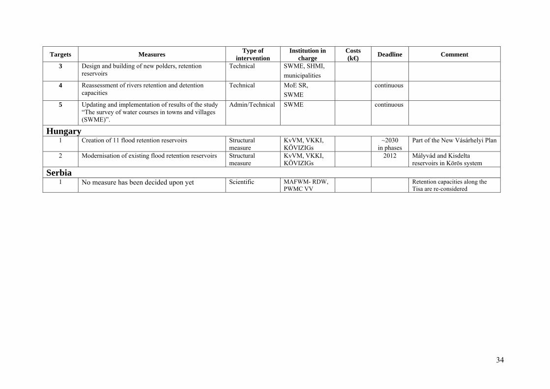
3 Design and building of new polders, retention reservoirs
Technical SWME, SHMI,
municipalities
4 Reassessment of rivers retention and detention capacities
Technical MoE SR,
SWME
continuous
5 Updating and implementation of results of the study “The survey of water courses in towns and villages (SWME)”.
Admin/Technical SWME continuous
Hungary 1 Creation of 11 flood retention reservoirs Structural
measure KvVM, VKKI, KÖVIZIGs
~2030 in phases
Part of the New Vásárhelyi Plan
2 Modernisation of existing flood retention reservoirs Structural measure
KvVM, VKKI, KÖVIZIGs
2012 Mályvád and Kisdelta reservoirs in Körös system
Serbia 1 No measure has been decided upon yet Scientific MAFWM- RDW,
PWMC VV Retention capacities along the
Tisa are re-considered
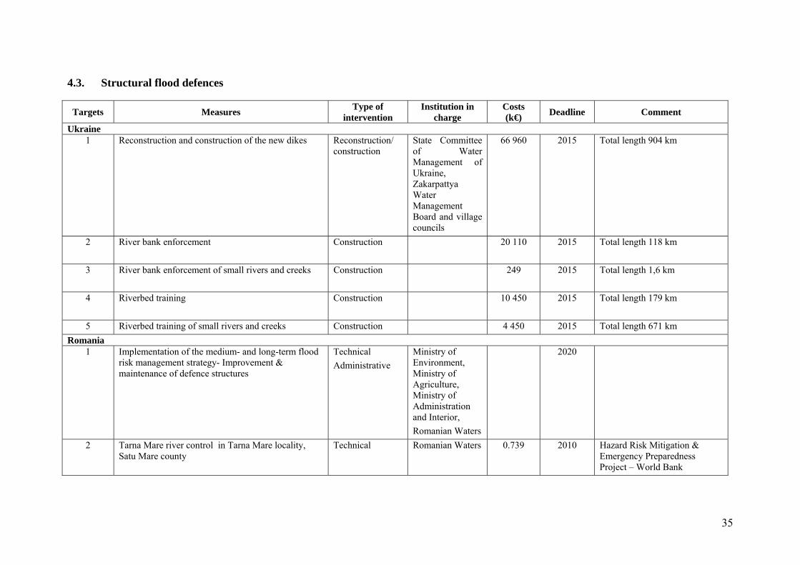
35
4.3. Structural flood defences
Targets Measures Type of
intervention Institution in
charge Costs (k€)
Deadline Comment
Ukraine 1 Reconstruction and construction of the new dikes Reconstruction/
construction State Committee of Water Management of Ukraine, Zakarpattya Water Management Board and village councils
66 960 2015 Total length 904 km
2 River bank enforcement Construction 20 110 2015 Total length 118 km
3 River bank enforcement of small rivers and creeks Construction 249 2015 Total length 1,6 km
4 Riverbed training Construction 10 450 2015 Total length 179 km
5 Riverbed training of small rivers and creeks Construction 4 450 2015 Total length 671 km
Romania 1 Implementation of the medium- and long-term flood
risk management strategy- Improvement & maintenance of defence structures
Technical
Administrative
Ministry of Environment, Ministry of Agriculture, Ministry of Administration and Interior,
Romanian Waters
2020
2 Tarna Mare river control in Tarna Mare locality, Satu Mare county
Technical Romanian Waters 0.739 2010 Hazard Risk Mitigation & Emergency Preparedness Project – World Bank
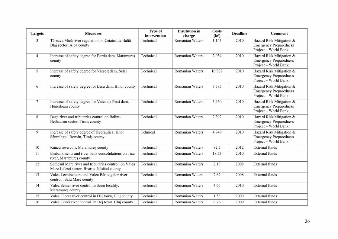
36
Targets Measures Type of
intervention Institution in
charge Costs (k€)
Deadline Comment
3 Târnava Mică river regulation on Cetatea de Baltă-Blaj sector, Alba county
Technical Romanian Waters 1.143 2010 Hazard Risk Mitigation & Emergency Preparedness Project – World Bank
4 Increase of safety degree for Berdu dam, Maramureş county
Technical Romanian Waters 2.034 2010 Hazard Risk Mitigation & Emergency Preparedness Project – World Bank
5 Increase of safety degree for Vârşolţ dam, Sălaj county
Technical Romanian Waters 10.832 2010 Hazard Risk Mitigation & Emergency Preparedness Project – World Bank
6 Increase of safety degree for Leşu dam, Bihor county Technical Romanian Waters 3.785 2010 Hazard Risk Mitigation & Emergency Preparedness Project – World Bank
7 Increase of safety degree for Valea de Peşti dam, Hunedoara county
Technical Romanian Waters 3.460 2010 Hazard Risk Mitigation & Emergency Preparedness Project – World Bank
8 Bega river and tributaries control on Balint-Bethausen sector, Timiş county
Technical Romanian Waters 2.397 2010 Hazard Risk Mitigation & Emergency Preparedness Project – World Bank
9 Increase of safety degree of Hydraulical Knot Sânmihaiul Român, Timiş county
Tehnical Romanian Waters 4.749 2010 Hazard Risk Mitigation & Emergency Preparedness Project – World Bank
10 Runcu reservoir, Maramureş county Technical Romanian Waters 82.7 2012 External funds
11 Embankments and river bank consolidations on Tisa river, Maramureş county
Technical Romanian Waters 18.53 2010 External funds
12 Someşul Mare river and tributaries control on Valea Mare-Leleşti sector, Bistriţa-Năsăud county
Technical Romanian Waters 2.13 2008 External funds
13 Valea Lechincioara and Valea Bârloagelor river control , Satu Mare county
Technical Romanian Waters 2.62 2008 External funds
14 Valea Seinel river control in Seini locality, Maramureş county
Technical Romanian Waters 4.65 2010 External funds
15 Valea Olpret river control in Dej town, Cluj county Technical Romanian Waters 1.53 2009 External funds
16 Valea Ocnei river control in Dej town, Cluj county Technical Romanian Waters 0.76 2009 External funds
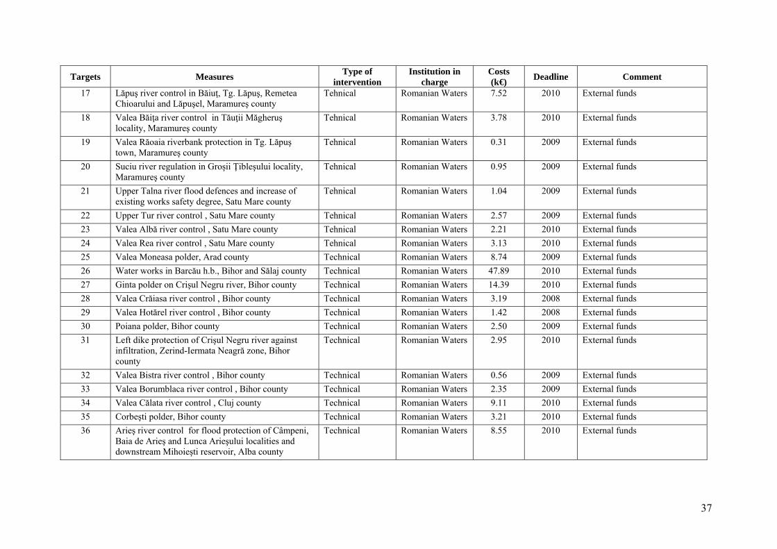
37
Targets Measures Type of
intervention Institution in
charge Costs (k€)
Deadline Comment
17 Lăpuş river control in Băiuţ, Tg. Lăpuş, Remetea Chioarului and Lăpuşel, Maramureş county
Tehnical Romanian Waters 7.52 2010 External funds
18 Valea Băiţa river control in Tăuţii Măgheruş locality, Maramureş county
Tehnical Romanian Waters 3.78 2010 External funds
19 Valea Răoaia riverbank protection in Tg. Lăpuş town, Maramureş county
Tehnical Romanian Waters 0.31 2009 External funds
20 Suciu river regulation in Groşii Ţibleşului locality, Maramureş county
Tehnical Romanian Waters 0.95 2009 External funds
21 Upper Talna river flood defences and increase of existing works safety degree, Satu Mare county
Tehnical Romanian Waters 1.04 2009 External funds
22 Upper Tur river control , Satu Mare county Tehnical Romanian Waters 2.57 2009 External funds
23 Valea Albă river control , Satu Mare county Tehnical Romanian Waters 2.21 2010 External funds
24 Valea Rea river control , Satu Mare county Tehnical Romanian Waters 3.13 2010 External funds
25 Valea Moneasa polder, Arad county Technical Romanian Waters 8.74 2009 External funds
26 Water works in Barcău h.b., Bihor and Sălaj county Technical Romanian Waters 47.89 2010 External funds
27 Ginta polder on Crişul Negru river, Bihor county Technical Romanian Waters 14.39 2010 External funds
28 Valea Crăiasa river control , Bihor county Technical Romanian Waters 3.19 2008 External funds
29 Valea Hotărel river control , Bihor county Technical Romanian Waters 1.42 2008 External funds
30 Poiana polder, Bihor county Technical Romanian Waters 2.50 2009 External funds
31 Left dike protection of Crişul Negru river against infiltration, Zerind-Iermata Neagră zone, Bihor county
Technical Romanian Waters 2.95 2010 External funds
32 Valea Bistra river control , Bihor county Technical Romanian Waters 0.56 2009 External funds
33 Valea Borumblaca river control , Bihor county Technical Romanian Waters 2.35 2009 External funds
34 Valea Călata river control , Cluj county Technical Romanian Waters 9.11 2010 External funds
35 Corbeşti polder, Bihor county Technical Romanian Waters 3.21 2010 External funds
36 Arieş river control for flood protection of Câmpeni, Baia de Arieş and Lunca Arieşului localities and downstream Mihoieşti reservoir, Alba county
Technical Romanian Waters 8.55 2010 External funds
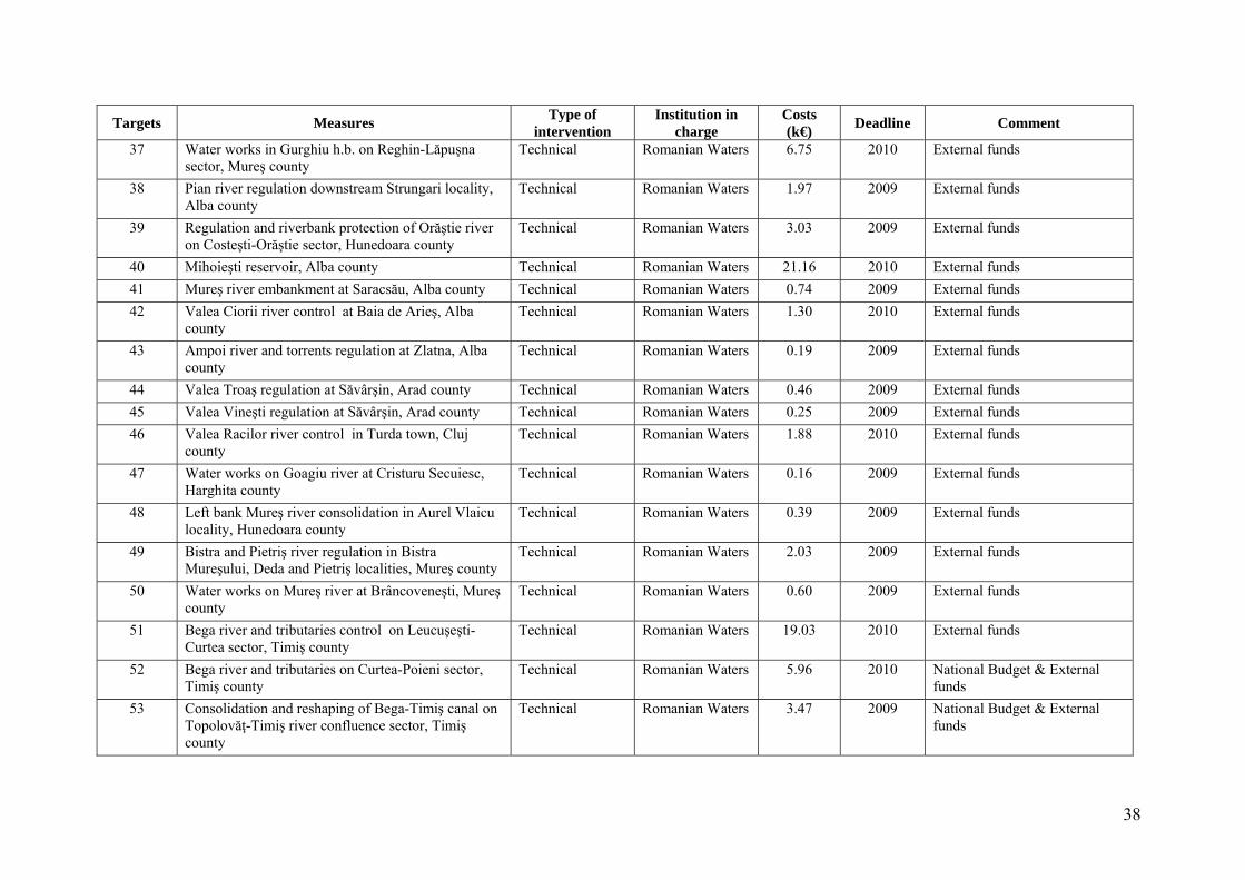
38
Targets Measures Type of
intervention Institution in
charge Costs (k€)
Deadline Comment
37 Water works in Gurghiu h.b. on Reghin-Lăpuşna sector, Mureş county
Technical Romanian Waters 6.75 2010 External funds
38 Pian river regulation downstream Strungari locality, Alba county
Technical Romanian Waters 1.97 2009 External funds
39 Regulation and riverbank protection of Orăştie river on Costeşti-Orăştie sector, Hunedoara county
Technical Romanian Waters 3.03 2009 External funds
40 Mihoieşti reservoir, Alba county Technical Romanian Waters 21.16 2010 External funds
41 Mureş river embankment at Saracsău, Alba county Technical Romanian Waters 0.74 2009 External funds
42 Valea Ciorii river control at Baia de Arieş, Alba county
Technical Romanian Waters 1.30 2010 External funds
43 Ampoi river and torrents regulation at Zlatna, Alba county
Technical Romanian Waters 0.19 2009 External funds
44 Valea Troaş regulation at Săvârşin, Arad county Technical Romanian Waters 0.46 2009 External funds
45 Valea Vineşti regulation at Săvârşin, Arad county Technical Romanian Waters 0.25 2009 External funds
46 Valea Racilor river control in Turda town, Cluj county
Technical Romanian Waters 1.88 2010 External funds
47 Water works on Goagiu river at Cristuru Secuiesc, Harghita county
Technical Romanian Waters 0.16 2009 External funds
48 Left bank Mureş river consolidation in Aurel Vlaicu locality, Hunedoara county
Technical Romanian Waters 0.39 2009 External funds
49 Bistra and Pietriş river regulation in Bistra Mureşului, Deda and Pietriş localities, Mureş county
Technical Romanian Waters 2.03 2009 External funds
50 Water works on Mureş river at Brâncoveneşti, Mureş county
Technical Romanian Waters 0.60 2009 External funds
51 Bega river and tributaries control on Leucuşeşti-Curtea sector, Timiş county
Technical Romanian Waters 19.03 2010 External funds
52 Bega river and tributaries on Curtea-Poieni sector, Timiş county
Technical Romanian Waters 5.96 2010 National Budget & External funds
53 Consolidation and reshaping of Bega-Timiş canal on Topolovăţ-Timiş river confluence sector, Timiş county
Technical Romanian Waters 3.47 2009 National Budget & External funds
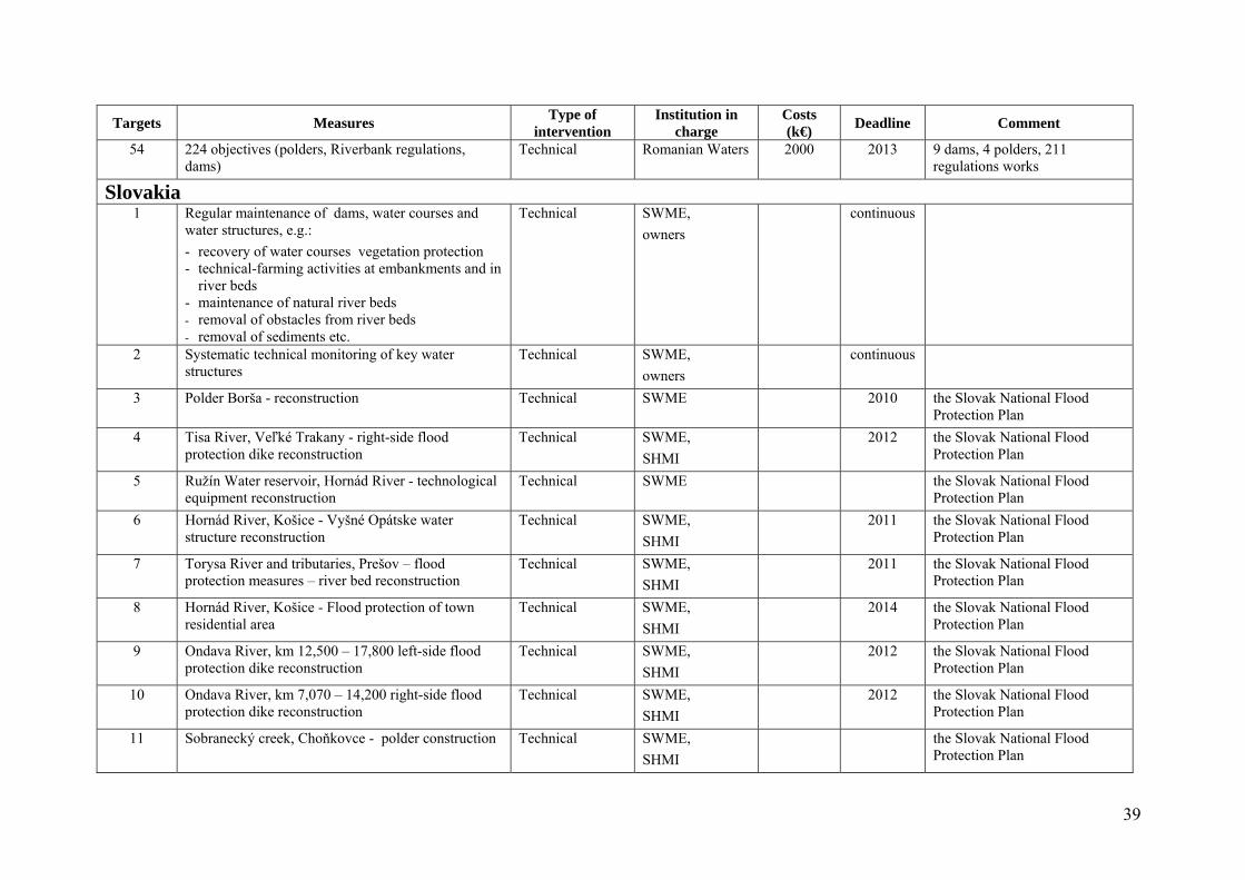
39
Targets Measures Type of
intervention Institution in
charge Costs (k€)
Deadline Comment
54 224 objectives (polders, Riverbank regulations, dams)
Technical Romanian Waters 2000 2013 9 dams, 4 polders, 211 regulations works
Slovakia 1 Regular maintenance of dams, water courses and
water structures, e.g.:
- recovery of water courses vegetation protection - technical-farming activities at embankments and in
river beds - maintenance of natural river beds - removal of obstacles from river beds
- removal of sediments etc.
Technical SWME,
owners
continuous
2 Systematic technical monitoring of key water structures
Technical SWME,
owners
continuous
3 Polder Borša - reconstruction Technical SWME 2010 the Slovak National Flood Protection Plan
4 Tisa River, Veľké Trakany - right-side flood protection dike reconstruction
Technical SWME,
SHMI
2012 the Slovak National Flood Protection Plan
5 Ružín Water reservoir, Hornád River - technological equipment reconstruction
Technical SWME the Slovak National Flood Protection Plan
6 Hornád River, Košice - Vyšné Opátske water structure reconstruction
Technical SWME,
SHMI
2011 the Slovak National Flood Protection Plan
7 Torysa River and tributaries, Prešov – flood protection measures – river bed reconstruction
Technical SWME,
SHMI
2011 the Slovak National Flood Protection Plan
8 Hornád River, Košice - Flood protection of town residential area
Technical SWME,
SHMI
2014 the Slovak National Flood Protection Plan
9 Ondava River, km 12,500 – 17,800 left-side flood protection dike reconstruction
Technical SWME,
SHMI
2012 the Slovak National Flood Protection Plan
10 Ondava River, km 7,070 – 14,200 right-side flood protection dike reconstruction
Technical SWME,
SHMI
2012 the Slovak National Flood Protection Plan
11 Sobranecký creek, Choňkovce - polder construction Technical SWME,
SHMI
the Slovak National Flood Protection Plan
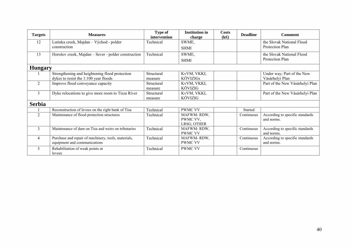
40
Targets Measures Type of
intervention Institution in
charge Costs (k€)
Deadline Comment
12 Lutinka creek, Majdan – Východ - polder construction
Technical SWME,
SHMI
the Slovak National Flood Protection Plan
13 Horošov creek, Majdan – Sever - polder construction Technical SWME,
SHMI
the Slovak National Flood Protection Plan
Hungary 1 Strengthening and heightening flood protection
dykes to resist the 1:100 year floods Structural measure
KvVM, VKKI, KÖVIZIGs
Under way; Part of the New Vásárhelyi Plan
2 Improve flood conveyance capacity Structural measure
KvVM, VKKI, KÖVIZIG
Part of the New Vásárhelyi Plan
3 Dyke relocations to give more room to Tisza River Structural measure
KvVM, VKKI, KÖVIZIG
Part of the New Vásárhelyi Plan
Serbia 1 Reconstruction of levees on the right bank of Tisa Technical PWMC VV Started 2 Maintenance of flood protection structures Technical MAFWM- RDW,
PWMC VV, LRSG, OTHER
Continuous According to specific standards and norms.
3 Maintenance of dam on Tisa and weirs on tributaries Technical MAFWM- RDW, PWMC VV
Continuous According to specific standards and norms.
4 Purchase and repair of machinery, tools, materials, equipment and communications
Technical MAFWM- RDW, PWMC VV
Continuous According to specific standards and norms.
5 Rehabilitation of weak points at levees
Technical PWMC VV Continuous
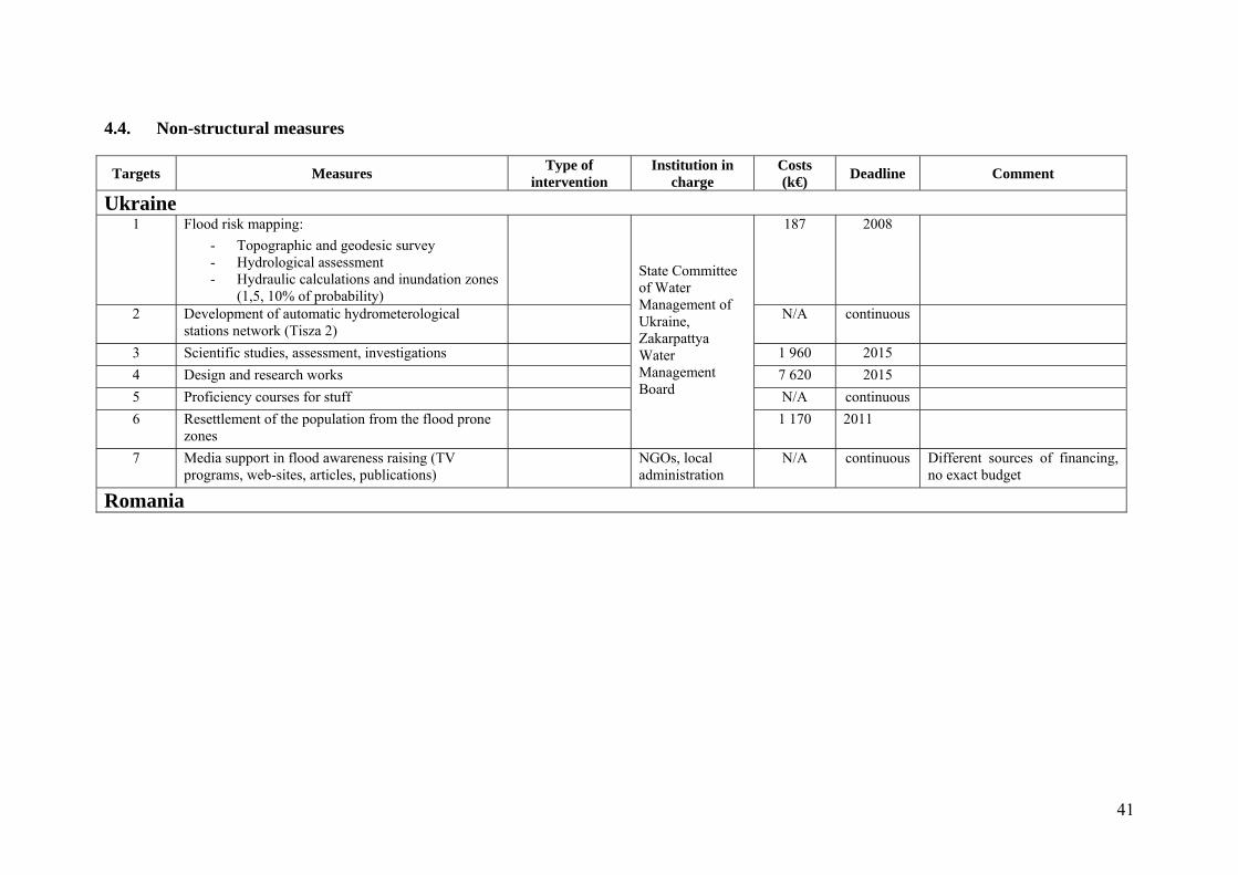
41
4.4. Non-structural measures
Targets Measures Type of
intervention Institution in
charge Costs (k€)
Deadline Comment
Ukraine 1 Flood risk mapping:
- Topographic and geodesic survey - Hydrological assessment - Hydraulic calculations and inundation zones
(1,5, 10% of probability)
State Committee of Water Management of Ukraine, Zakarpattya Water Management Board
187 2008
2 Development of automatic hydrometerological stations network (Tisza 2)
N/A continuous
3 Scientific studies, assessment, investigations 1 960 2015
4 Design and research works 7 620 2015
5 Proficiency courses for stuff N/A continuous
6 Resettlement of the population from the flood prone zones
1 170 2011
7 Media support in flood awareness raising (TV programs, web-sites, articles, publications)
NGOs, local administration
N/A continuous Different sources of financing, no exact budget
Romania
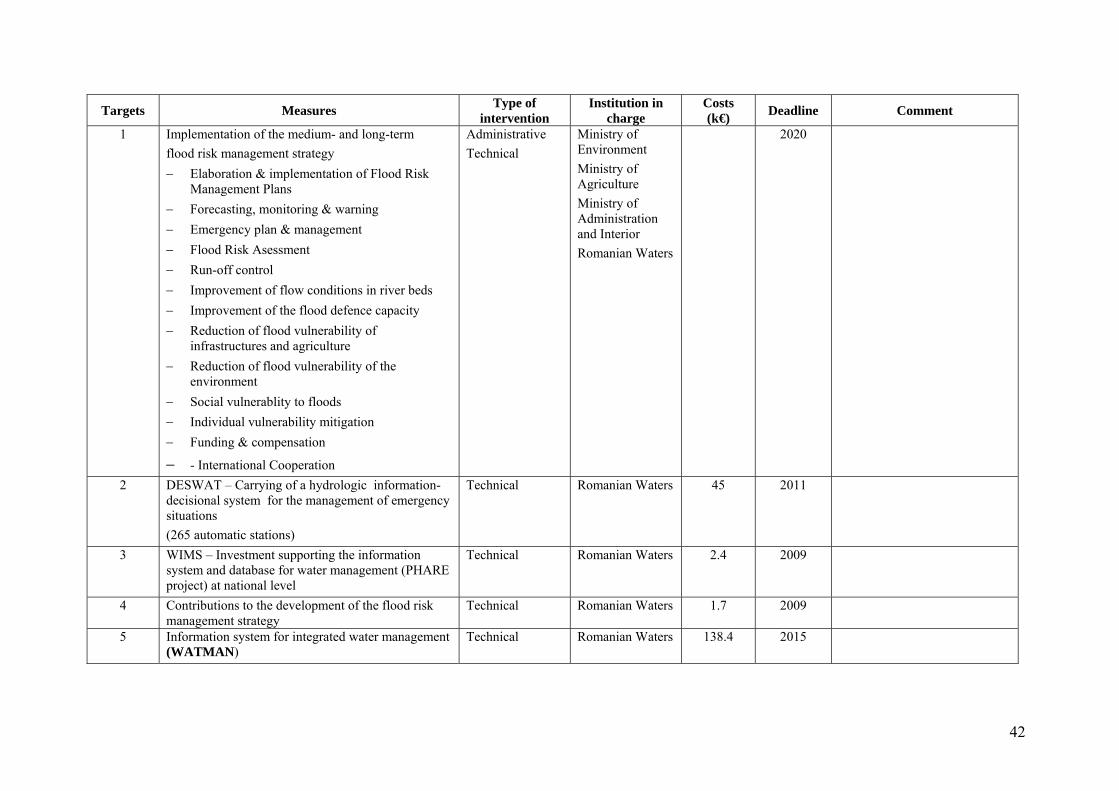
42
Targets Measures Type of
intervention Institution in
charge Costs (k€)
Deadline Comment
1 Implementation of the medium- and long-term
flood risk management strategy
Elaboration & implementation of Flood Risk Management Plans
Forecasting, monitoring & warning
Emergency plan & management
Flood Risk Asessment
Run-off control
Improvement of flow conditions in river beds
Improvement of the flood defence capacity
Reduction of flood vulnerability of infrastructures and agriculture
Reduction of flood vulnerability of the environment
Social vulnerablity to floods
Individual vulnerability mitigation
Funding & compensation
- International Cooperation
Administrative
Technical Ministry of Environment
Ministry of Agriculture
Ministry of Administration and Interior
Romanian Waters
2020
2 DESWAT – Carrying of a hydrologic information-decisional system for the management of emergency situations
(265 automatic stations)
Technical Romanian Waters 45 2011
3 WIMS – Investment supporting the information system and database for water management (PHARE project) at national level
Technical Romanian Waters 2.4 2009
4 Contributions to the development of the flood risk management strategy
Technical Romanian Waters 1.7 2009
5 Information system for integrated water management (WATMAN)
Technical Romanian Waters 138.4 2015
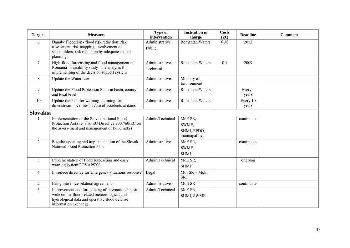
43
Targets Measures Type of
intervention Institution in
charge Costs (k€)
Deadline Comment
6 Danube Floodrisk - flood risk reduction: risk assessment, risk mapping, involvement of stakeholders, risk reduction by adequate spatial planning.
Administrative
Public
Romanian Waters 6.38 2012
7 High-flood forecasting and flood management in Romania – feasibility study - the analysis for implementing of the decision support system
Administrative
Technical
Romanian Waters 0.1 2009
8 Update the Water Law Administrative Ministry of Environment
9 Update the Flood Protection Plans at basin, county and local level
Administrative Romanian Waters Every 4 years
10 Update the Plan for warning-alarming for downstream localities in case of accidents at dams
Administrative Romanian Waters Every 10 years
Slovakia 1 Implementation of the Slovak national Flood
Protection Act (i.e. also EU Directive 2007/60/EC on the assess-ment and management of flood risks)
Admin/Technical MoE SR,
SWME,
SHMI, EPDO, municipalities
continuous
2 Regular updating and implementation of the Slovak National Flood Protection Plan
Administrative MoE SR,
SWME,
SHMI
continuous
3 Implementation of flood forecasting and early warning system POVAPSYS
Admin/Technical MoE SR,
SHMI
ongoing
4 Introduce directive for emergency situations response Legal MoI SR + MoE SR,
5 Bring into force bilateral agreements Administrative MoE SR continuous
6 Improvement and formalizing of international basin wide online flood related meteorological and hydrological data and operative flood defense information exchange
Admin/Technical MoE SR,
SHMI, SWME
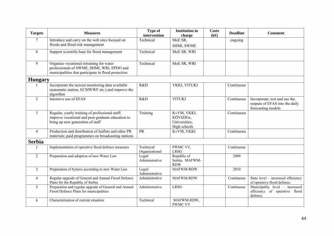
44
Targets Measures Type of
intervention Institution in
charge Costs (k€)
Deadline Comment
7 Introduce and carry on the web sites focused on floods and flood risk management
Technical MoE SR,
SHMI, SWME
ongoing
8 Support scientific base for flood management Technical MoE SR, WRI
9 Organize vocational retraining for water professionals of SWME, SHMI, WRI, EPDO and municipalities that participate in flood protection
Technical MoE SR, WRI
Hungary 1 Incorporate the newest monitoring data available
(automatic station, ECMWWF etc.) and improve the algorithm
R&D VKKI, VITUKI Continuous
2 Intensive use of EFAS R&D VITUKI Continuous Incorporate, test and use the outputs of EFAS into the daily forecasting models
3 Regular, yearly training of professional staff; improve vocational and post-graduate education to bring up new generation of staff
Training KvVM, VKKI, KÖVIZIGs, Universities, High schools
Continuous
4 Production and distribution of leaflets and other PR materials; paid programmes on broadcasting stations
PR KvVM, VKKI Continuous
Serbia 1 Implementation of operative flood defence measures Technical/
Organizational PWMC VV, LRSG
Continuous
2 Preparation and adoption of new Water Law Legal/ Administrative
Republic of Serbia, MAFWM-RDW
2009
3 Preparation of bylaws according to new Water Law Legal/ Administrative
MAFWM-RDW 2010
4 Regular upgrade of General and Annual Flood Defence Plans for the Republic of Serbia
Administrative MAFWM-RDW Continuous State level – increased efficiency of operative flood defence.
5 Preparation and regular upgrade of General and Annual Flood Defence Plans for municipalities
Administrative LRSG Continuous Municipality level – increased efficiency of operative flood defence.
6 Characterisation of current situation Technical MAFWM-RDW, PWMC VV
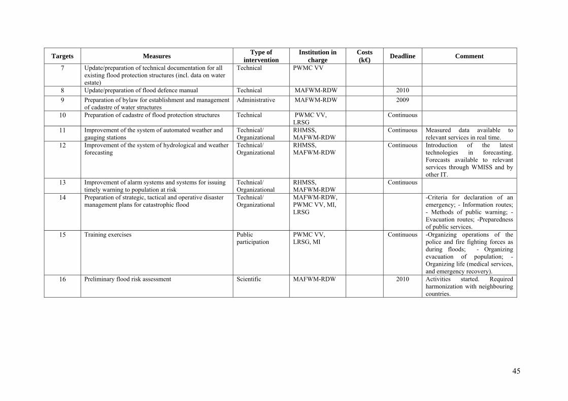
45
Targets Measures Type of
intervention Institution in
charge Costs (k€)
Deadline Comment
7 Update/preparation of technical documentation for all existing flood protection structures (incl. data on water estate)
Technical PWMC VV
8 Update/preparation of flood defence manual Technical MAFWM-RDW 2010 9 Preparation of bylaw for establishment and management
of cadastre of water structures Administrative MAFWM-RDW 2009
10 Preparation of cadastre of flood protection structures Technical PWMC VV, LRSG
Continuous
11 Improvement of the system of automated weather and gauging stations
Technical/ Organizational
RHMSS, MAFWM-RDW
Continuous Measured data available to relevant services in real time.
12 Improvement of the system of hydrological and weather forecasting
Technical/ Organizational
RHMSS, MAFWM-RDW
Continuous Introduction of the latest technologies in forecasting. Forecasts available to relevant services through WMISS and by other IT.
13 Improvement of alarm systems and systems for issuing timely warning to population at risk
Technical/ Organizational
RHMSS, MAFWM-RDW
Continuous
14 Preparation of strategic, tactical and operative disaster management plans for catastrophic flood
Technical/ Organizational
MAFWM-RDW, PWMC VV, MI, LRSG
-Criteria for declaration of an emergency; - Information routes; - Methods of public warning; - Evacuation routes; -Preparedness of public services.
15 Training exercises Public participation
PWMC VV, LRSG, MI
Continuous -Organizing operations of the police and fire fighting forces as during floods; - Organizing evacuation of population; - Organizing life (medical services, and emergency recovery).
16 Preliminary flood risk assessment Scientific MAFWM-RDW 2010 Activities started. Required harmonization with neighbouring countries.
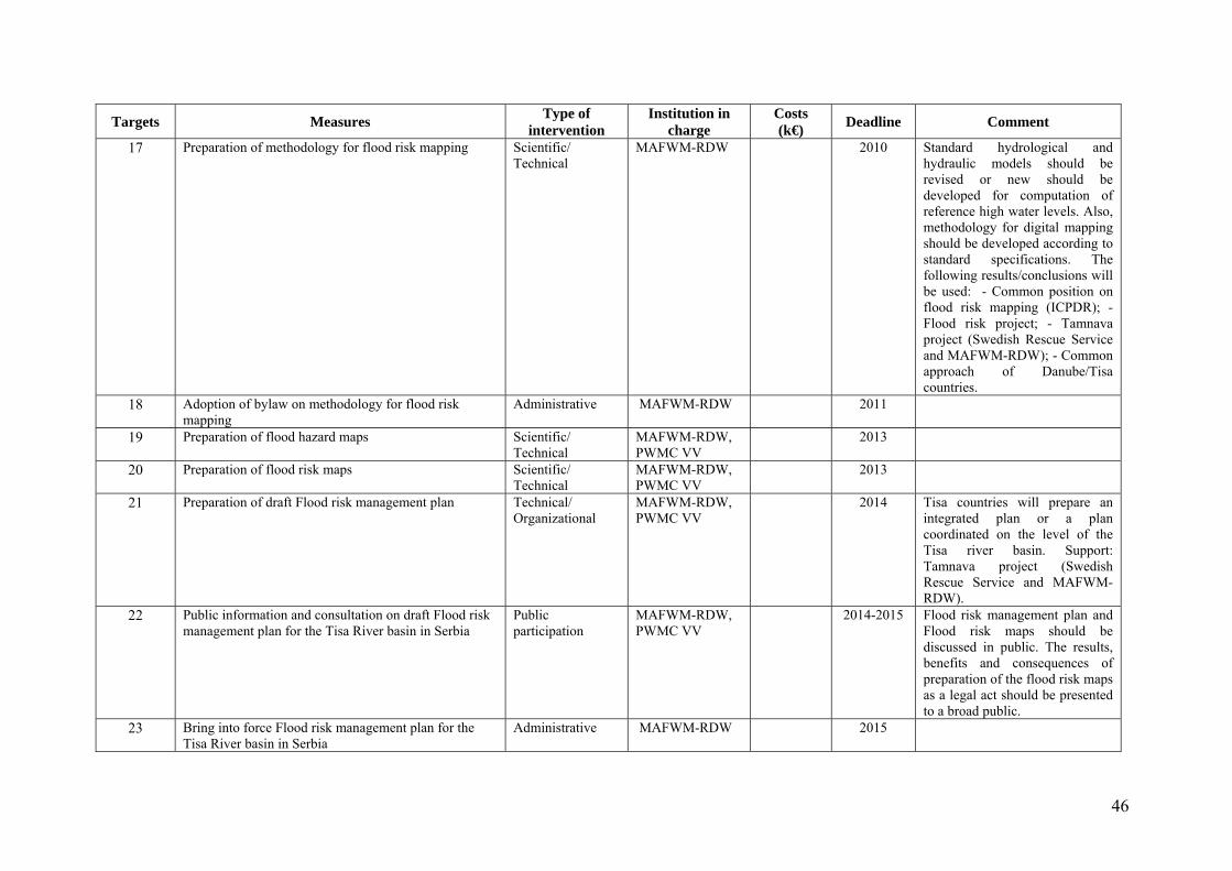
46
Targets Measures Type of
intervention Institution in
charge Costs (k€)
Deadline Comment
17 Preparation of methodology for flood risk mapping Scientific/ Technical
MAFWM-RDW 2010 Standard hydrological and hydraulic models should be revised or new should be developed for computation of reference high water levels. Also, methodology for digital mapping should be developed according to standard specifications. The following results/conclusions will be used: - Common position on flood risk mapping (ICPDR); -Flood risk project; - Tamnava project (Swedish Rescue Service and MAFWM-RDW); - Common approach of Danube/Tisa countries.
18 Adoption of bylaw on methodology for flood risk mapping
Administrative MAFWM-RDW 2011
19 Preparation of flood hazard maps Scientific/ Technical
MAFWM-RDW, PWMC VV
2013
20 Preparation of flood risk maps Scientific/ Technical
MAFWM-RDW, PWMC VV
2013
21 Preparation of draft Flood risk management plan Technical/ Organizational
MAFWM-RDW, PWMC VV
2014 Tisa countries will prepare an integrated plan or a plan coordinated on the level of the Tisa river basin. Support: Tamnava project (Swedish Rescue Service and MAFWM-RDW).
22 Public information and consultation on draft Flood risk management plan for the Tisa River basin in Serbia
Public participation
MAFWM-RDW, PWMC VV
2014-2015 Flood risk management plan and Flood risk maps should be discussed in public. The results, benefits and consequences of preparation of the flood risk maps as a legal act should be presented to a broad public.
23 Bring into force Flood risk management plan for the Tisa River basin in Serbia
Administrative MAFWM-RDW 2015
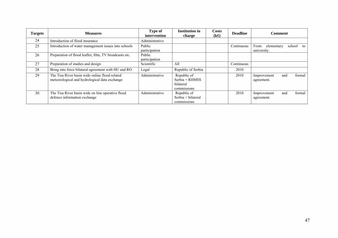
47
Targets Measures Type of
intervention Institution in
charge Costs (k€)
Deadline Comment
24 Introduction of flood insurance Administrative 25 Introduction of water management issues into schools Public
participation Continuous From elementary school to
university. 26 Preparation of flood leaflet, film, TV broadcasts etc. Public
participation
27 Preparation of studies and design Scientific All Continuous 28 Bring into force bilateral agreement with HU and RO Legal Republic of Serbia 2010 29 The Tisa River basin wide online flood related
meteorological and hydrological data exchange Administrative Republic of
Serbia + RHMSS bilateral commissions
2010 Improvement and formal agreement.
30 The Tisa River basin wide on line operative flood defence information exchange
Administrative Republic of Serbia + bilateral commissions
2010 Improvement and formal agreement.
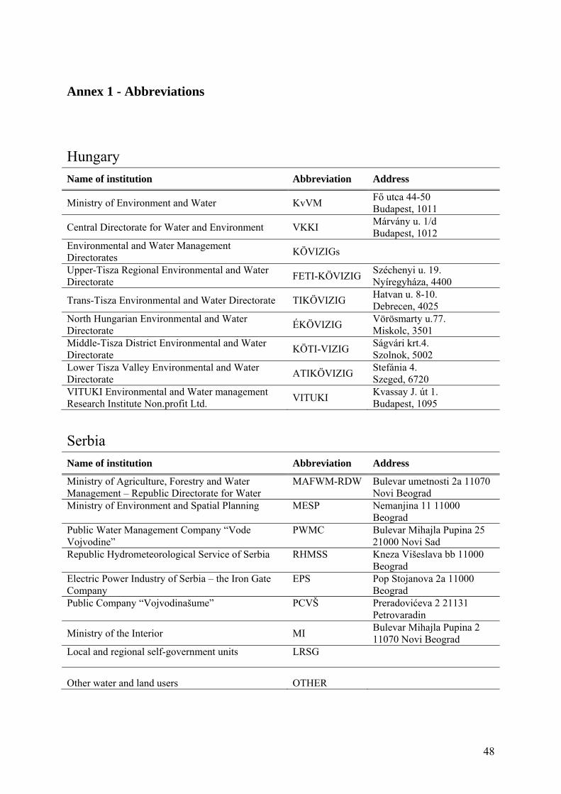
48
Annex 1 - Abbreviations
Hungary
Name of institution Abbreviation Address
Ministry of Environment and Water KvVM Fő utca 44-50 Budapest, 1011
Central Directorate for Water and Environment VKKI Márvány u. 1/d Budapest, 1012
Environmental and Water Management Directorates
KÖVIZIGs
Upper-Tisza Regional Environmental and Water Directorate
FETI-KÖVIZIG Széchenyi u. 19. Nyíregyháza, 4400
Trans-Tisza Environmental and Water Directorate TIKÖVIZIG Hatvan u. 8-10. Debrecen, 4025
North Hungarian Environmental and Water Directorate
ÉKÖVIZIG Vörösmarty u.77. Miskolc, 3501
Middle-Tisza District Environmental and Water Directorate
KÖTI-VIZIG Ságvári krt.4. Szolnok, 5002
Lower Tisza Valley Environmental and Water Directorate
ATIKÖVIZIG Stefánia 4. Szeged, 6720
VITUKI Environmental and Water management Research Institute Non.profit Ltd.
VITUKI Kvassay J. út 1. Budapest, 1095
Serbia
Name of institution Abbreviation Address
Ministry of Agriculture, Forestry and Water Management – Republic Directorate for Water
MAFWM-RDW Bulevar umetnosti 2a 11070 Novi Beograd
Ministry of Environment and Spatial Planning MESP Nemanjina 11 11000 Beograd
Public Water Management Company “Vode Vojvodine”
PWMC Bulevar Mihajla Pupina 25 21000 Novi Sad
Republic Hydrometeorological Service of Serbia RHMSS Kneza Višeslava bb 11000 Beograd
Electric Power Industry of Serbia – the Iron Gate Company
EPS Pop Stojanova 2a 11000 Beograd
Public Company “Vojvodinašume” PCVŠ Preradovićeva 2 21131 Petrovaradin
Ministry of the Interior MI Bulevar Mihajla Pupina 2 11070 Novi Beograd
Local and regional self-government units LRSG
Other water and land users OTHER