Embed Size (px)
Citation preview

EARTHQUAKE - PAGE 4.2-1
PUYALLUP TRIBE OF INDIANS ALL HAZARD MITIGATION PLAN
2017 – 2022 EDITION
SUB-SECTION 4G.2
PUYALLUP TRIBE ALL HAZARD MITIGATION PLAN EARTHQUAKE HAZARD
Table of Contents
TABLE OF CONTENTS ............................................................................................... 1
IDENTIFICATION DESCRIPTION ................................................................................ 2
DEFINITION ............................................................................................................. 2 TYPES .................................................................................................................... 2 SECONDARY HAZARDS: ................................................................................................ 3
PROFILE ................................................................................................................... 5
LOCATION AND EXTENT ............................................................................................... 5 VULNERABILITY ....................................................................................................... 15 IMPACTS ............................................................................................................... 16
RESOURCE DIRECTORY .......................................................................................... 24
REGIONAL ............................................................................................................. 24 NATIONAL ............................................................................................................. 24
ENDNOTES ............................................................................................................. 26
EARTHQUAKE - PAGE 4.2-2
PUYALLUP TRIBE OF INDIANS ALL HAZARD MITIGATION PLAN
2017 – 2022 EDITION
Identification Description
Definition1
An earthquake is a naturally induced shaking of the ground. It is caused by an abrupt shift of
rock along a fracture in the earth’s crust called a fault. Within seconds, an earthquake releases
stress that has slowly accumulated within the rock. Sometimes the release occurs near the surface
and sometimes it comes from deep within the crust.
Types2
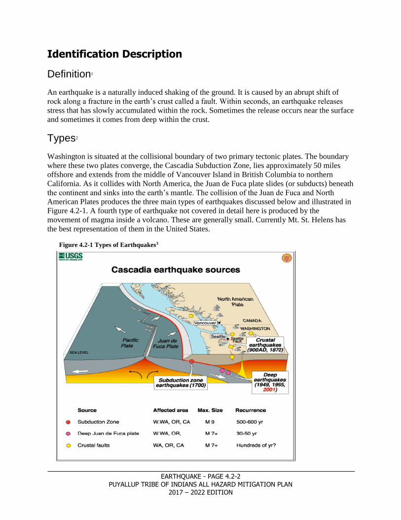
Washington is situated at the collisional boundary of two primary tectonic plates. The boundary
where these two plates converge, the Cascadia Subduction Zone, lies approximately 50 miles
offshore and extends from the middle of Vancouver Island in British Columbia to northern
California. As it collides with North America, the Juan de Fuca plate slides (or subducts) beneath
the continent and sinks into the earth’s mantle. The collision of the Juan de Fuca and North
American Plates produces the three main types of earthquakes discussed below and illustrated in
Figure 4.2-1. A fourth type of earthquake not covered in detail here is produced by the
movement of magma inside a volcano. These are generally small. Currently Mt. St. Helens has
the best representation of them in the United States.
Figure 4.2-1 Types of Earthquakes3

EARTHQUAKE - PAGE 4.2-3
PUYALLUP TRIBE OF INDIANS ALL HAZARD MITIGATION PLAN
2017 – 2022 EDITION
Intraplate Earthquakes Intraplate earthquakes in the Pacific Northwest are deep earthquakes. They lay, within a range of
approximately 15 to 60 miles in depth and are within the subducting Juan de Fuca (oceanic)
Plate. Most of the ones that impact Pierce County occur near or in an area where the Juan de
Fuca Plate bends slightly as it slips beneath the North American (continental) Plate. These deep
events typically have few, if any aftershocks. Intraplate earthquakes are the most frequent large
events that strike Pierce County.
Crustal Earthquakes
Shallow crustal earthquakes occur primarily in western Washington, the northeastern flanks of
the Cascade Range, and in the Columbia Plateau. These earthquakes occur primarily at depths of
20 miles or less. Since 1992, there is rapidly accumulating evidence that large crustal
earthquakes occur on the Seattle Fault in areas of high population. In Pierce County there is
ongoing research to understand the history and threat posed by the Tacoma Fault.4 As research
continues, developing information on the nature of the risk from the Tacoma Fault will have a
significant effect on hazard assessments for Pierce County.
Cascadia Subduction Zone Earthquakes
Cascadia Subduction zone (interplate) earthquakes occur less frequently than intraplate events,
but probably more frequently than large crustal earthquakes. Because Cascadia earthquakes have
a very large source (the fault could rupture along its entire length from Vancouver Island to
northern California) the ground motion may last for four minutes in Pierce County and be of
lower frequency than motions from earthquakes like the Nisqually (February 28, 2001). These
long-periods of sustained ground motion, especially when combined with long period waves and
soft soils, may be more damaging to large structures such as both of the Tacoma Narrows
Bridges. Ground motion can be especially damaging to large buildings with complex designs, as
opposed to many smaller buildings and homes.
Secondary hazards:
Liquefaction: Soft soils or human-made fills can subside or experience liquefaction or
lateral spreading in an earthquake. Liquefaction commonly causes lack of support for
structures located on the liquefiable soils. You may have ground failures; ground
cracking or boils from layers of sand sometimes located a number of meters under the
surface. Lateral spreading is in fact a landslide that occurs on very shallow slopes due to
the liquefiable nature of the soil. Noteworthy liquefaction took place in Puyallup during
the 1949 earthquake and there were examples of it in both the 1965 and 2001
earthquakes. Liquefaction is directly related to the level of soil saturation combined with
layers of sand. The sands that failed in Pierce County in many cases were sand deposits
from Mount Rainier lahars, see Map 4.2-2 Liquefaction in the Puget Sound Basin and
Map 4.2-4 Pierce County Seismic Hazard.
Landslides and Rockfalls: These can be triggered on steep slopes. Earthquakes have
caused large and disastrous landslides, including debris flows from volcanoes. Loss of

EARTHQUAKE - PAGE 4.2-4
PUYALLUP TRIBE OF INDIANS ALL HAZARD MITIGATION PLAN
2017 – 2022 EDITION
strength in sensitive, clay-rich soils can also cause landslides and other ground failures;
see the Landslide and Volcanic Hazard Chapters of the Pierce County HIRA.
Dam Failure: This is also a possibility during an earthquake. Likely causes are either a
fracture of the retention wall or the failure of the soils under the structure. The
Department of Ecology’s inventory of dams lists 56 dams in Pierce County that, at peak
storage, hold over ten acre-feet. This includes Mud Mountain Dam on the Pierce/King
County border. In addition
Howard Hanson Dam on the
Green River in King County
could impact portions of
Pierce County if it had a
catastrophic collapse. Of
these, 13 are considered to be
high hazard, 15 are
considered to be a significant
hazard and 29 are listed as
having a low hazard potential.
Levee Failure: Levees in their
role as a flood control feature
exist to protect the land and
the facilities on it from flood
waters. Being largely built on
liquefiable valley soils,
damage to the levees is a real
possibility. If an earthquake
with resulting damage to
levees happens during flood
season, extensive flooding
could occur before the levees
were repaired. The real threat
here is not to the levees
themselves but if the river
floods before the levee
damage can be corrected the
resulting threat is to the
population, facilities and
infrastructure situated behind
those levees.
o Tsunamis and Seiches: Vertical displacement, co-seismic subsidence, or earthquake
induced landslides can all cause tsunamis and seiches; see Tsunami Hazard Chapter of
the HIRA.5
Map 4.2-1 Major Faults in the Puget Sound Basin

EARTHQUAKE - PAGE 4.2-5
PUYALLUP TRIBE OF INDIANS ALL HAZARD MITIGATION PLAN
2017 – 2022 EDITION
Profile
Location and Extent
Earthquakes directly and indirectly affect all of Pierce County and the Planning Area. To
illustrate the earthquake risk in the County and the Planning Area, Figure 4.2-1, on page 2,
shows the location of the various types of earthquakes that affect the Pacific Northwest. Map
4.2-1 shows the major faults in the Puget Sound. Map 4.2-2 shows the location of the Seattle
Fault and the various branches of the Tacoma Fault and Map 4.1-3 shows the seismic hazard
areas throughout Pierce County as defined by areas of liquefiable soils. Map 4.1-4 shows the
seismic hazard area throughout the Planning Area.
The scientific studies that have been done that created these maps state that the entire region is at
risk to the earthquake hazard. Continuing updated information on the Tacoma Fault is revealing
it and the surrounding geologic structure in greater detail yearly. One of the methods has been
through the use of Light Detection and Ranging (LIDAR) mapping. The documented examples
of these land-level changes date to about 1,100 years ago, though much remains to be learned
about its extent and shape. As can be seen from Map 4.2-2 the various segments of the fault
appear to run westward and northwestward from Tacoma across the Kitsap Peninsula6 Ongoing
research will continue to change our understanding of the Tacoma Fault and other local faults
and their potential for a damaging earthquake to affect Pierce County.
Map 4.2-2 Seattle and Tacoma Fault Segments
While the entire County experiences shaking during earthquakes, areas of liquefaction
experience even greater shaking. Map 4.2-3 illustrates the location and extent of Pierce County’s
seismic hazard based on areas of liquefaction. As illustrated, the majority of liquefiable soils in

EARTHQUAKE - PAGE 4.2-6
PUYALLUP TRIBE OF INDIANS ALL HAZARD MITIGATION PLAN
2017 – 2022 EDITION
Map 4.2-3 Pierce County Seismic Hazard
EARTHQUAKE - PAGE 4.2-7
PUYALLUP TRIBE OF INDIANS ALL HAZARD MITIGATION PLAN 2017 – 2022 EDITION
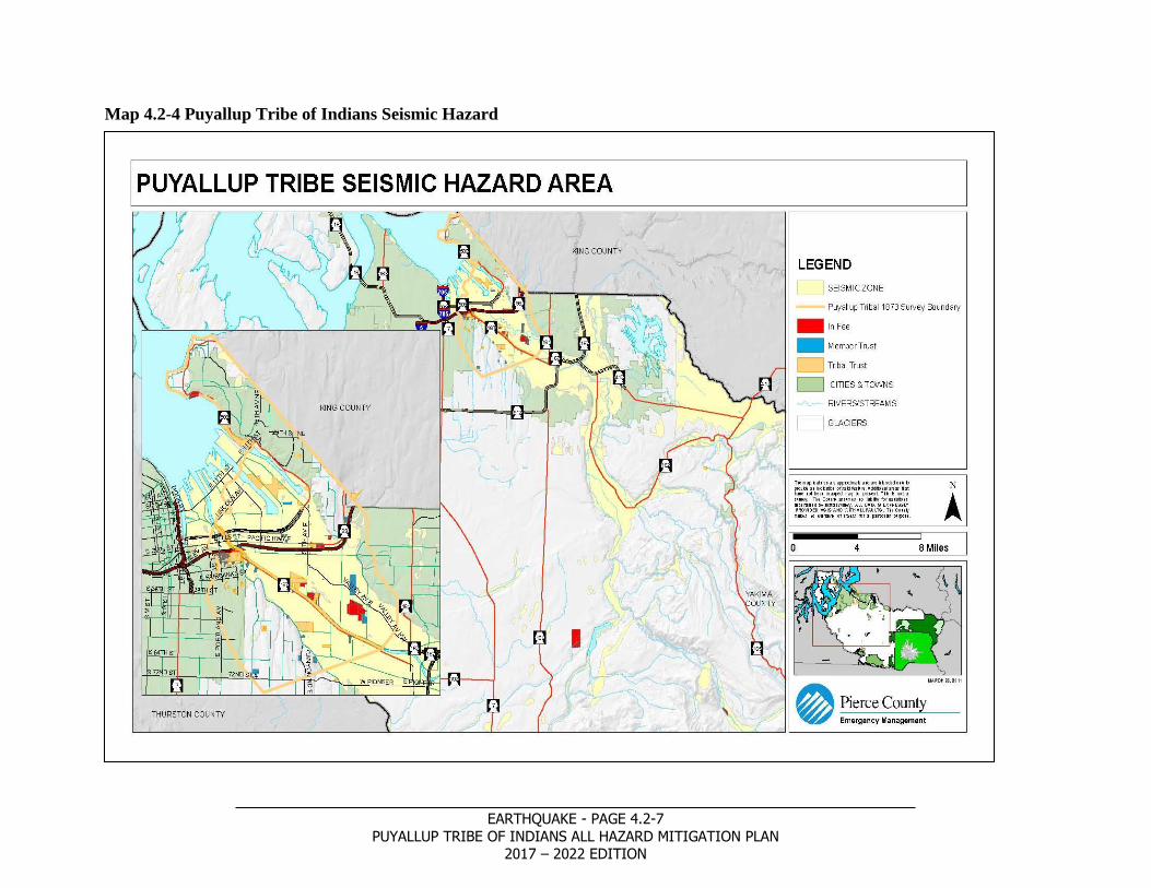
Map 4.2-4 Puyallup Tribe of Indians Seismic Hazard

EARTHQUAKE - PAGE 4.2-8
PUYALLUP TRIBE OF INDIANS ALL HAZARD MITIGATION PLAN
2017 – 2022 EDITION
Map 4.2-5 Puyallup Tribe of Indians Downtown Liquefaction Susceptibility

EARTHQUAKE - PAGE 4.2-9
PUYALLUP TRIBE OF INDIANS ALL HAZARD MITIGATION PLAN
2017 – 2022 EDITION
Map 4.2-6 Puyallup Tribe of Indians Fife/Puyallup Liquefaction Susceptibility

EARTHQUAKE - PAGE 4.2-10
PUYALLUP TRIBE OF INDIANS ALL HAZARD MITIGATION PLAN
2017 – 2022 EDITION
Map 4.2-7 Puyallup Tribe of Indians Port of Tacoma Liquefaction Susceptibility

EARTHQUAKE - PAGE 4.2-11
PUYALLUP TRIBE OF INDIANS ALL HAZARD MITIGATION PLAN
2017 – 2022 EDITION
Map 4.2-8 Puyallup Tribe of Indians Orting/Wilkeson Liquefaction Susceptibility

EARTHQUAKE - PAGE 4.2-12
PUYALLUP TRIBE OF INDIANS ALL HAZARD MITIGATION PLAN
2017 – 2022 EDITION
Pierce County are located in the County’s river valleys. The largest area of liquefiable soils is the
Puyallup River Valley while the Carbon, White, and Nisqually River Valleys are also
liquefaction hazard areas. The areas with the highest liquefaction hazard are located in both
incorporated and unincorporated areas of the County. Auburn, Buckley, Eatonville, Fife, Milton,
Puyallup, Orting, South Prairie, Sumner, and Tacoma all have at least some of their land located
in these areas.
Map 4.2-4 illustrates the location and extent of the Puyallup Tribe Reservation’s seismic hazard
based on areas of liquefaction. With the majority of the Reservation located along the Puyallup
River valley the risk for liquefaction is extremely high. Many of the Tribe’s Trust Lands are
located within these areas. Map 4.2-5 through Map 4.2-8 allows for a detailed identification of
specific Tribal Trust Lands and their vulnerability to liquefaction. This will allow the Puyallup
Tribe to easily identify which buildings are at the highest risk for mitigation efforts or knowledge
of at highest risk areas for future construction.
The other area of earthquake risk is in the area of landslide potential. Earthquakes tend to create
landslides as a secondary hazard. This can be especially true during periods when the soils are
saturated. In Pierce County this can go from October through June depending on the fall and
winter weather. The landslide potential can be seen in the Landslide section on maps 4.3-1, 4.3-2
and 4.3-3.
Occurrences7
Over the last 100 years, a large area
of the state has experienced
earthquake damage. The majority of
the largest earthquakes felt in
Washington have occurred in the
Puget Sound region between Olympia
and the Canadian border, in the
Cascade Mountains, and along the
Washington-Oregon border. Medium
to large magnitude earthquakes
(greater than 5.0) have occurred
repeatedly in the Puget Sound region.
Map 4.2-9 shows the location, date,
and magnitude of major earthquakes
since 1872 in the Pacific Northwest.
In addition Table 4.2-1 lists some of
the notable earthquakes felt in Pierce
County and is followed by a
discussion of occurrences by type of
earthquake.
Intraplate (Benioff Zone8) Earthquakes9
Map 4.2--9 Major Pacific Northwest Earthquakes1

EARTHQUAKE - PAGE 4.2-13
PUYALLUP TRIBE OF INDIANS ALL HAZARD MITIGATION PLAN
2017 – 2022 EDITION
The magnitude 6.8 Nisqually earthquake on February 28, 2001 caused extensive non-structural
damage throughout the region. Although estimates are still being totaled, to date losses from this
event are greater than $350 million statewide. The large earthquakes of 1965 (magnitude 6.5),
1949 (magnitude 7.1), and 1946 (magnitude 6.3) killed 17 people and caused more than $340
million (2002 dollars) in property damage in several counties. Since 1870 there have been six
significant intraplate earthquakes in the Puget Sound basin.10 Based on the historical record we
can say that the actual recurrence rate of events this size is about every 23 years.
Table 4.2-1 Notable Earthquakes, Magnitude 5.0 or Greater, Felt in Pierce County11,
DATE YY/MM/DD
(UTC)TIME HH:MM:SS
LATITUDE (N)
LONGITUDE (W)
DEPTH
(KM) MAG COMMENTS
1872/12/15 05:40:00 47.75N 119.87W 0.0 6.8 14.5 KM SE OF CHELAN, WA
1880/12/12 20:40:00 47.50N 122.50W 0.0 6.0 12.3 KM SE OF BREMERTON, WA
1882/04/30 10:40:00 47.40N 122.59W 0.0 5.7 18.7 KM S OF BREMERTON, WA
1891/03/07 07:40:00 47.50N 121.75W 0.0 5.0 2.7 KM E OF NORTH BEND, WA
1891/11/29 23:21:00 48.00N 123.50W 0.0 5.6 13.5 KM SSW OF PORT ANGELES, WA
1904/03/17 04:20:00 47.79N 123.00W 0.0 5.3 27.6 KM WNW OF POULSBO, WA
1931/12/31 15:25:00 47.50N 123.00W 0.0 5.0 28.9 KM WSW OF BREMERTON, WA
1932/07/18 06:01:00 48.00N 121.80W 0.0 5.7 15.6 KM SE OF GRANITE FALLS, WA
1932/08/06 22:16:00 47.70N 122.30W 0.0 5.0 7.2 KM WNW OF KIRKLAND, WA
1939/11/13 07:45:54 47.40N 122.59W 31.0 6.2 18.7 KM S OF BREMERTON, WA
1945/04/29 20:16:17 47.40N 121.69W 0.0 5. 7 12.5 KM SSE OF NORTH BEND, WA
1945/04/30 07:45:45 47.40N 121.69W 0.0 5.0 12.5 KM SSE OF NORTH BEND, WA
1946/02/15 03:17:47 47.29N 122.90W 25.0 5.8 28.4 KM N OF OLYMPIA, WA
1946/02/15 12:17:15 46.86N 122.26W 0.0 5.0 0.3 KM NW OF EATONVILLE, WA
1946/02/23 08:54:53 47.04N 122.88W 0.0 5.0 0.0 KM SE OF OLYMPIA, WA
1946/06/23 15:13:00 49.80N 125.30W 0.0 7.4 26.3 KM WNW OF COURTENAY, BC
1948/09/24 22:35:00 47.85N 122.58W 0.0 5.0 14.0 KM NNE OF POULSBO, WA
1949/04/13 19:55:43 47.09N 122.75W 54.0 7.1 12.3 KM ENE OF OLYMPIA, WA
1954/05/15 13:02:32 47.40N 122.50W 0.0 5.0 18.9 KM NNW OF TACOMA, WA
1965/04/29 15:28:43 47.40N 122.40W 57.0 6.5 18.3 KM N OF TACOMA, WA
1980/05/18 15:32:11 46.20N 122.18W 2.8 5.7 1.0 KM NNE OF MT ST HELENS, WA
1981/02/14 06:09:27 46.34N 122.23W 7.3 5.2 1.8 KM N OF ELK LAKE, WA
1981/05/28 09:10:45 46.52N 121.39W 3.2 5.0 4.4 KM ENE OF GOAT ROCKS, WA
1990/04/14 05:33:26 48.84N 122.16W 12.6 5.0 4.7 KM ENE OF DEMING, WA
1995/01/29 03:11:22 47.38N 122.36W 15.8 5.0 17.5 KM NNE OF TACOMA, WA
1996/05/03 04:04:22 47.76N 121.87W 4.3 5.4 8.5 KM ENE OF DUVALL, WA
1999/07/03 01:43:54 47.07N 123.46W 40.7 5.8 8.0 KM N OF SATSOP, WA

EARTHQUAKE - PAGE 4.2-14
PUYALLUP TRIBE OF INDIANS ALL HAZARD MITIGATION PLAN
2017 – 2022 EDITION
DATE YY/MM/DD
(UTC)TIME HH:MM:SS
LATITUDE (N)
LONGITUDE (W)
DEPTH
(KM) MAG COMMENTS
2001/02/28 18:54:32 47.14N 122.72W 51.9 6.8 17.0 KM NE OF OLYMPIA, WA 1361-DR-
WA 2001/06/10 13:19:11 47.16N 123.50W 40.7 5.0 18.3 KM N OF SATSOP, WA
Crustal Earthquakes12
Best available science indicates that on the Tacoma Fault uplift to the north and subsidence to the
south occurred most recently in A.D. 800–1200, not necessarily in a single year. The age range
of this uplift on the north side of the Tacoma Fault includes times of co-seismic uplift and
subsidence at many sites around Puget Sound. The lack of estimates for the Tacoma Fault
reflects an early stage of research into the Holocene history of this structure.13 It must be
understood that damage could also come from earthquakes on other crustal faults from both
within and outside Pierce County. Of particular concern are the Seattle Fault and the West
Rainier Seismic Zone. Other small localized faults like the Burnett, Wilkeson, Miller and
Devereaux faults in the eastern portion of the County might cause some localized problems but
are not expected to cause widespread damage. There is always the possibility that an
undiscovered fault underlying the glacial till that covers much of the County that could cause a
damaging earthquake.
Cascade Subduction Zone Earthquakes14
In addition to crustal and intraplate earthquakes, research indicates that the subducting Juan de
Fuca Plate has generated great earthquakes. These earthquakes estimated to be in the range of
magnitude 8 to 9 appear to have occurred at uneven intervals over the past several thousand
years. At least 13 great subduction earthquakes may have occurred in the Pacific Northwest over
the past 7,000 years. The most recent great subduction earthquake in Washington State occurred
over 300 years ago on January 26, 1700. At this time it appears that the mean recurrence rate is
about 550 years. The actual recurrence rate is highly variable with the shortest time period
between them being around 100 years, and the longest time span being around 1,100 years.15
For each of these sources, the largest earthquakes recur at poorly known, probably irregular,
intervals. On average, the intervals are on the order of decades for the intraplate earthquakes on
the Juan de Fuca Plate, millennia for the best-known of the upper-plate faults (the Seattle Fault),
and centuries for the plate boundary.
Recurrence Rate Although the earthquake record in Washington State is relatively short to form precise estimates
of the recurrence rate for earthquakes, the record we do have allows at least an estimate of the
overall rate. Realizing the fact that earthquakes happen daily in Washington, we are only
interested in the ones that potentially cause damage. Taking into account the three different types
of earthquakes listed above and the past occurrences we know of, we find that for the short
historical record we have the intraplate earthquakes are the ones with by far the shortest
recurrence rate. It must be realized that the 36 year period between the 1965 quake and the 2001
earthquake may be closer to the real average and that the 23 year average from the record may be
a little short. So until better scientific evidence allows an improved estimate of the actual

EARTHQUAKE - PAGE 4.2-15
PUYALLUP TRIBE OF INDIANS ALL HAZARD MITIGATION PLAN
2017 – 2022 EDITION
recurrence rate we will list the probability of recurrence for the earthquake hazard in the
Planning Area and Pierce County to be less than 40 years.
Vulnerability
While the entire County experiences shaking during earthquakes, areas of liquefaction
experience even greater shaking. Map 4.2-4 illustrates the location and extent of the Planning
Area’s seismic hazard based on areas of liquefaction. As illustrated on Map 4.2-3, the majority
of liquefiable soils are located in the River Valleys. The largest area of liquefiable soils is the
Puyallup River Valley while the Carbon, White, and Nisqually River Valleys are also
liquefaction hazard areas. The areas with the highest liquefaction hazard are located in both
incorporated and unincorporated areas of the County. Auburn, Buckley, Eatonville, Fife, Milton,
Puyallup, Orting, South Prairie, Sumner, and Tacoma all have at least some of their land located
in these areas including the Planning area.
Because of their nature, earthquakes impact the entire Planning Area. Some parts of the
Planning Area are more at risk than others because of the presence of liquefiable soils. As
shown on Map 4.2-4, approximately 50% of the developed land is on these areas of greater risk.
The majority of high seismic risk is located within the river valleys, where the liquefaction risk is
high and completely covers the valley floor. There are some small pockets of land that are prone
to dynamic settlements, as well as a larger area near the northeast corner of the Planning Area.
Some of the ridges along the river valley may be vulnerable to earthquake-induced landslides,
especially as more development occurs along the hillside. Earthquakes tend to create landslides
as a secondary hazard. This can be especially true during periods when the soils are saturated. In
Pierce County this can go from October through June depending on the fall and winter weather.
The landslide potential can be seen in the Landslide section on maps 4.3-1 and 4.3-2.
Finally, areas near the northwest of the Puyallup River and the Port of Tacoma (Commencement
Bay) area susceptible to earthquake induced underwater landslides or delta failures (for more on
the vulnerability, see Sub-Section 4.4, Tsunami’s).
Planning Area
The Planning Team determined that Planning Area has a medium vulnerability to the earthquake
hazard because of the following factors: probability of recurrence, the Area’s proximity to faults,
the predominant presence of soft soils, and the age and type of structures. The areas noted above
as being at risk to liquefaction and dynamic settlement increase the vulnerability for structures,
infrastructure, and resources located there. The hillsides that comprise the valley walls may be
vulnerable to landslides, especially as they continue to develop.
In the entire Planning Area, over 18,000 acres are vulnerable to earthquakes and earthquake-
induced events. The total damage to the Planning Area could exceed $8 billion (the assessed
value of all parcels in the Planning Area).
A more detailed vulnerability assessment by the Planning Team showed that approximately
9,068 acres (50% of the Planning Area) are located in areas of moderate to high liquefaction
making those acres even more vulnerable to the earthquake hazard. The total estimated losses to

EARTHQUAKE - PAGE 4.2-16
PUYALLUP TRIBE OF INDIANS ALL HAZARD MITIGATION PLAN
2017 – 2022 EDITION
these parcels would equal $4 billion. See maps 4.2-5 to 4.2-8 for detailed liquefaction potential
to Tribal Trust properities.
For Tribal Trust parcels located in the Planning Area, all 485 parcels are vulnerable to
earthquake hazard. The total estimated losses to these parcels would equal $300 million.
Of the 485 Tribal Trust parcels in the Planning Area, 162 parcels (33.4%) are located in areas of
moderate to high liquefaction. The total estimated losses to these parcels would equal $232
million.
Impacts
All discussion of the impacts of an earthquake has to take into account the magnitude, epicenter
and focus of the earthquake. This includes whether it is a subduction quake on the junction of the
Juan de Fuca and North American plates off the coast of Washington, a deep earthquake like the
2001 Nisqually quake or one on either the Seattle or Tacoma faults. Other variables outside the
obvious impact of magnitude of the quake include weather both before and after the earthquake,
the time of day, time of year, and the percentage of older buildings of construction techniques
that are not up to current building code standards. For the purposes of this section, preliminary
impacts will be from the Scenario for a Magnitude 6.7 Earthquake on the Seattle Fault.16
Health and Safety of Persons in the Affected Area at the Time of the Incident
Depending on the size and location of the earthquake the affect on persons in the impacted area
is expected to range from a repeat of the Nisqually quake of 2001 up to those from a hypothetical
6.7 or larger earthquake on one of the major faults in Puget Sound or a large subduction quake
located off the coast of Washington.
The magnitude 6.8 Nisqually Earthquake of February 28, 2001 resulted in one death and
approximately 400 recorded injuries, including a dozen that were serious, throughout the Puget
Sound Basin.17 The expectation is that similar quake would produce similar results.
The affects of a surface rupture on the Seattle or Tacoma faults could lead to a much greater loss
of life and injuries. Losses are estimated to be equivalent to those from the Northridge California
quake of 1994. However, in Northridge, the time of day dramatically decreased the actual
number of casualties. That earthquake, striking at 4:30 in the morning, did not cause the number
of deaths and injuries that would have happened at a later hour. At that time the number of
people on the roads and bridges that collapsed was very low as were the staff in the buildings
that collapsed. In contrast estimated losses here in the Puget Sound Basin are expected to top
1,600 fatalities and 24,000 injuries.18 These estimates are based on one distinct scenario, a 6.7
earthquake on the Seattle Fault. A variation on this either up or down in the magnitude could
have a significant effect on the outcome.
In discussing a subduction quake, it must be understood that while the State has experienced
quakes of this type possibly as high as magnitude 9, all of them were prior to settlers with a
written language entering the State of Washington. The violent shaking expected with a surface
quake on the Tacoma or Seattle faults will be attenuated to a certain extent by the distance from
the actual fracture zone. Located off the Washington coast, the earthquake waves will have to

EARTHQUAKE - PAGE 4.2-17
PUYALLUP TRIBE OF INDIANS ALL HAZARD MITIGATION PLAN
2017 – 2022 EDITION
travel over 100 miles to reach Pierce County. On the other hand “(T)his particular type of
earthquake is especially hazardous to tall buildings, which could lead to significant fatalities in
downtown areas.”19
In previous large earthquakes the potential for an outbreak of disease appears to increase. This
can be caused by polluted water sources, the eating of spoiled food, and the inhalation of dust
kicked up by the quake. In addition here in Pierce County there could be environmental injuries
such as hypothermia if the earthquake happened during the winter months.
Figure 4.2-2 Salmon Beach, Tacoma Washington – Following Feb. 2001 Earthquake
Health and Safety of Personnel Responding to the Incident
Responders are subject to a number of hazards in the response phase of the emergency. Damaged
fire stations could prevent fire personnel from utilizing all the equipment with which they are
used to responding. Already damaged structures could collapse during search and rescue
operations, especially during aftershocks. Response personnel, by the very nature of their work
are putting themselves in harm’s way, not just from structural collapse during aftershocks but
also from further landslide activity and respiratory problems due to the inhaling of quantities of
dust and microbes stirred up by the earthquake. In addition they can be exposed to bacteria and
chemicals in the environment they are working in, sometimes without realizing what the
particular dangers are. “Following the Loma Prieta earthquake, about 20% of post-earthquake
injuries were caused by toxic materials.”20 For those who are caught in the dust cloud created by
an earthquake the respiratory problems could be similar to those experienced by first responders
to the World Trade Center collapse in 2001.21 This can be shown to be a problem across many
different emergency responses. It correlates with the amount of toxins and dust that are in the

EARTHQUAKE - PAGE 4.2-18
PUYALLUP TRIBE OF INDIANS ALL HAZARD MITIGATION PLAN
2017 – 2022 EDITION
environment, for example approximately 80% of Red Cross responders who went to work on
Hurricane Katrina response returned home with respiratory infections.22
First responders frequently have adverse psychological reactions to trauma and especially
disasters. Long term psychological impacts were noticed years ago, such as after the collapse of
the Hyatt Regency Hotel walkway in Kansas City, Missouri in 1981, and eventually led to the
development of Critical Incident Stress Management. Divorce and suicide rates are higher than
the norm“(S)tress is not like a light switch—the images of such tragic events often haunt the
responder into his or her home life, piling more pressure on other events. Ill health effects can
include high blood pressure, sleep disorders, alcohol or sleeping aid abuse, anger, withdrawal
from family members, over protectiveness for family members, and even paranoia.”23,24
Continuity of Operations and Delivery of Services
For a large earthquake impacting Pierce County, continuity of operations will be severely taxed
for many, if not most, of the agencies and jurisdictions located therein. The impacts affecting
continuity of operations include:
o Death or injury to staff limiting the number of staff able to fill normal operational
duties;
o Inability of staff to respond to their work sites due to road closures from debris on
the roads, liquefaction or lateral spreading damaging the roads, and bridges or
overpasses damaged closing arterials in particular;
o Staff absenteeism while checking on or taking care of family, and handling
damage to home or other personal property;
o Damage to communications systems will limit organizations’ ability to coordinate
their own resources, and it will also limit their ability to pull together a full picture
of the damage suffered in their jurisdiction and to request assistance if needed
o Damage to facilities and equipment; and
o Damage to the water, energy and sewer systems connected to agency facilities
will not allow operations to continue in their normal manner.
Due to the limitations mentioned above, delivery of services will be heavily impacted by a large
earthquake. Infrastructure damage or destruction combined with lack of staff will retard delivery
of normal governmental services.
Law enforcement operations will be taxed to the maximum. Road closures, prevention of citizens
entering hazardous areas, control of looting, responding to search and rescue operations, etc.
combined with a decrease in available staff due to all the factors listed above will severely limit
normal day-to-day operations. Most individual law enforcement officers operate independently
of others in their jurisdiction. Since many of them have their equipment with them, including
cars, they may be able to assist at least in the area they are at when the earthquake happens.
Fire response will be impacted in a similar vein, however for many of them they will have to
report to a station where they can respond from. Between the inability to get to their station and
the possibility that the stations and equipment may be damaged or destroyed the response will be
compromised. Many fire stations, especially the older ones, even though they have survived
previous moderate quakes may not survive a large one. Even if a station is not destroyed or
collapsed, a racking of the walls could jam the bay doors closed.
EARTHQUAKE - PAGE 4.2-19
PUYALLUP TRIBE OF INDIANS ALL HAZARD MITIGATION PLAN
2017 – 2022 EDITION
Public works and utilities will not have the ability to have services back up and operational, in
many cases, for days, weeks or even months. Repair of roads, bridges, water and sewer lines, the
electric grid and telephone lines and towers will tax these utilities to the maximum. Even with
the importation of mutual aid and other assistance from other portions of the state and other
states, the service delivery will be slow to develop and spotty at best for some time.
Schools will be unable to fulfill normal expectations. Damage to schools’ infrastructure as well
as the public infrastructure of roads and utilities will close down schools at least temporarily.
Those that might be able to be operational will, in many cases, have to act as temporary shelters
for those displaced by the earthquake. Immediately after the earthquake if school is in session
they may have to house students for days until parents are able to retrieve them.
Property, Facilities, and Infrastructure
Any large earthquake on the Seattle or Tacoma Faults or from many other faults in Washington
State will create damage to the property, facilities and infrastructure either owned by
jurisdictions in Pierce County or needed to support their economy and citizens. This includes
damage to buildings, electrical grids, telephone service, including cell operations, water and
sewer utilities, port facilities, transportation systems, and both natural gas and liquid fuel
pipelines.
A number of factors will determine the effect of ground shaking on the building stock and
infrastructure of any area. These include: soil composition, age of the facilities, focus (depth of
the quake) or, epicenter (point on the earth’s surface directly over the focus), weather previous to
the event surface faulting subsidence and uplift.
First is soil composition. Soft and liquefiable soils will both intensify ground shaking and in the
case of liquefiable soils lose structural integrity. Earthquake waves moving along the surface of
the ground have different characteristics depending on the soil composition they encounter.
These surface waves, when they progress from one soil type to another change. They tend to
travel slower through soft soils than they do through hard soils or bedrock. Yet the energy
contained in the wave stays the same. The result is that as the wave changes speed the amplitude
will change in relation to it, increasing in soft soils and decreasing in hard soils. This increase in
wave amplitude in soft soils can damage structures, especially unreinforced masonry and pre-
1970 tilt up structures.25
When the soil loses structural integrity, liquefaction or lateral spreading may be the result. This
is especially prevalent in areas of artificial fill like on the Tacoma Tide Flats and the valley
bottoms like the Puyallup and Nisqually where thousands of years of silt and sand washing down
the river combined with lahar debris has created soils prone to it. In cases like this, buildings or
portions of buildings built on it may sink; see Figure 4.2-3 Liquefaction, Niigata Japan, 1964.26
In the case of lateral spreading, it can move railroad tracks, bend or collapse roads, move cranes
or do other damage associated with the soil under the facility moving, see Figure 4.2-4 Lateral
spreading along North Deschutes Parkway in Thurston County.27 This damage, while in many
cases not as spectacular looking as buildings tipped over by liquefaction, can have a major
impact on the community. For emergency operations it limits the ability of emergency workers
to respond to incidents throughout the community and it can prevent people from bringing the

EARTHQUAKE - PAGE 4.2-20
PUYALLUP TRIBE OF INDIANS ALL HAZARD MITIGATION PLAN
2017 – 2022 EDITION
Figure 4.2-4 Lateral Spreading –March 2001
Figure 4.2-3 Liquefaction, Niigata Japan 1964
community back to normal and developing its economic base until this portion of the
infrastructure has been repaired.
Secondly, much of the building stock that exists in Pierce County was built before current
earthquake codes were put into place and before there was much of an understanding of the
actual hazard that exists from earthquakes in Washington State. It was only towards the end of
the 1980s that geologists began to understand some of the processes that cause earthquakes in the
Pacific Northwest. Since that time both geologic research into our local earthquake hazard as
well as engineering studies of building response in earthquakes has shown that some of the older
building stock could have major structural problems, possibly to the point of collapse.
The third and fourth factors that will have a major bearing on the damage done to a community
and to its ability to recoup from its losses
are the depth of the earthquake (focus) and
the location of its epicenter in relation to
the rest of the County.
An intraplate earthquake located inside the
Juan de Fuca Plate as it dives under the
North American Plate will be deep enough
that the waves it generates will be
attenuated or lose some energy as they
propagate outwards from the focus. In such
a situation, even if the earthquake’s
epicenter is located in Pierce County the
damage will not be too catastrophic. This
was the case with the 2001, 1965 and 1949
earthquakes all of which had epicenters close to or in Pierce County, see Table 4.2-1 Notable
Earthquakes Magnitude 5.0 or Greater Felt in Pierce County.
Taking the same size earthquakes, with magnitudes 6.8, 6.5, and 7.1 respectively, and moving
them close to the surface could have caused damage similar to the Northridge, California (6.7),
Loma Prieta, California, (7.1), or Kobe, Japan (6.8) earthquakes. In each of these cases with the
epicenter of the quake, 2001 (Anderson
Island), 1965 (Des Moines) and 1949
(Nisqually Delta), deaths and injuries would
have been much more prevalent. Buildings
would have collapsed, fires would have
started, bridges and freeway overpasses
would have been more heavily damaged and
other lifelines would have been in disarray
or out of commission for long periods of
time.
This is the scenario that Pierce County is
looking at if there was an earthquake of that
size on the Tacoma Fault. In addition, any

EARTHQUAKE - PAGE 4.2-21
PUYALLUP TRIBE OF INDIANS ALL HAZARD MITIGATION PLAN
2017 – 2022 EDITION
earthquake on a surface fault close to Pierce County like the Seattle or Olympia faults will cause
damage in Pierce County although probably to a lesser degree, being some distance away.
A subduction zone earthquake will be located further away from Pierce County than the surface
quakes mentioned above and so the waves will be attenuated somewhat by the time they get to
Pierce County compared to their size on the coast. However the shaking could run for multiple
minutes. This shaking could continue for a much longer time than the intraplate earthquakes we
have historically had. While all of Pierce County is vulnerable to this type of earthquake, the
most vulnerable areas will be those containing soft soils, both natural and those created by
artificial fill.
The next factor that can influence the outcome of an earthquake is the weather. The weather
previous to the earthquake will have an affect on the eventual outcome. Rain saturating the
ground can increase both the potential for earthquake generated landslides and the probability
that liquefaction or lateral spreading will occur. This could increase the probability that pipes
could break. Lateral spreading under roads, railroad tracks and port facilities would increase
disrupting transportation and there could be an increase to building damage due to liquefaction.
The other area that could cause damage is actual surface disruption either from surface faulting,
or subsidence and uplift. Fault ruptures breaking the surface can rip buildings apart, destroy
bridges, offset roads, break pipelines, destroy sewer lines, and stretch or break transmission lines.
The same can be said for subsidence and uplift. Having a building, road or any other piece of
infrastructure where a portion of it either rises or falls in relation to the rest will break or destroy
it. Actually any piece of infrastructure either in the ground or on its surface can be broken or
destroyed by any of these three effects.
Changes in the ground can affect the water table. Wells may change their water levels or go dry.
Stream flows may be altered and on a macro scale landslides or other ground deformation may
change the course of streams or rivers.
The Environment
Impacts, or damage, to the environment may be thought of as two different processes. There is
direct change to the environment caused by the earthquake. This incorporates all the natural
damages such as landslides, coastal uplift, inundation of low lying areas with coastal subsidence
and tsunami damage. In contrast the other process involves the pollution that becomes endemic
in the aftermath of an earthquake that strikes an urban area or some part of the infrastructure
today.
Concerning traditional environmental changes due to earthquakes, while many times damaging
in the short term, many of the changes caused by them are overcome with time as the local
ecosystem absorbs them. These types of environmental effects have been happening for as long
as the land that is now Pierce County has been around. These types of impacts include:
Landslides will sometimes block streams or rivers forcing them to reroute, occasionally
causing lakes that swamp the local vegetation leaving a ghost forest standing in the water.
Landslides can increase erosion affecting fish habitats. They can cause tsunamis that can
damage coastlines.
Coastal uplift raises sections of the near shore marine environment above the tide line,
killing all near shore tidal life in the area raised above the tide line.
Coastal subsidence dropping areas of beach and near beach land so that water now covers
land that was recently dry. This can drown plants and animals in newly submerged areas
and in some areas lead to saltwater intrusion into the local ground water supply.

EARTHQUAKE - PAGE 4.2-22
PUYALLUP TRIBE OF INDIANS ALL HAZARD MITIGATION PLAN
2017 – 2022 EDITION
Tsunamis causing local erosion of the beaches, direct damage to plants and animals living
on the beach, and possible saltwater damage to non-salt tolerant species away from the
beach.
Today, however, there is another type of environmental damage that is the result of human
intervention. That is the damage caused by the release of hazardous chemicals and/or large
quantities of sewage. These can be released from many different sources including but not
limited to industrial plants, pipelines, overturned trucks, damaged ships or barges, railcars and
even school chemistry labs. These impacts to the environment include:
Air pollution: some chemicals released as gasses can cause immediate damage to plants,
animals and humans. Tanks filled with, for example, chlorine, ammonia or any other
hazardous gas can harm or kill animals, birds, and plants, not just in the area of the spill
but for some distance downwind depending on the chemical involved and the size of the
release. The damage will usually be temporary and physical recovery to the environment
will begin as soon as the gas dissipates.
Chemicals that spill either directly into or that have the ability to drain into lakes, ponds,
streams, rivers, or even drainage ditches could kill or create birth defects in fish and
marine mammals. In some areas they would pollute drinking water. Depending on the
chemicals involved and their ability to be either absorbed by the environment, or break
down quickly the environment may either recuperate quickly or be impacted for years or
even decades. Damage to port facilities could create spills into the waterways that tidal
currents could spread throughout the coastal areas of Puget Sound causing damage into
Kitsap, King, Pierce, and Thurston Counties.
Damage to wastewater treatment facilities, sewers, pump stations, etc. could lead to spills
of sewage or the inability of the treatment plant to process waste allowing it to flow
untreated into the local environment. This would have the same effect as many other
hazardous chemicals, polluting the environment for possibly weeks, but also creating
conditions that could with bacterial contamination lead to disease in both animals and
humans.
Spills onto land can, depending again on the type of chemical, either temporarily, as with
the case with many caustics or acids or permanently, as with spills of heavy metals or
many radioactive materials damage soils. Related to this is the absorption of material by
the soil may allow it to pollute groundwater and be transferred for some distance causing
damage. Depending on the ability of water and the chemical to leach through the
underlying layers of soil, clay, rock, etc. it could eventually reach and pollute the aquifer.
Economic and Financial Condition
The economic effects from a large damaging earthquake will be extensive and the overall
financial condition of most businesses, as well as local governments in Pierce County, will be
compromised.
Economic factors will be impacted first by the direct damage to homes, businesses and the
infrastructure. A number of factors come into play here. First, the housing stock will be affected,
and while some people have earthquake insurance, the majority does not. Most home
construction built to contemporary earthquake standards will probably not collapse, however
damage could be extensive to older structures especially those not connected to their
foundations. While assistance from FEMA and SBA will help with reconstruction, there could
still be a large gap in what is needed to get families back into their homes.

EARTHQUAKE - PAGE 4.2-23
PUYALLUP TRIBE OF INDIANS ALL HAZARD MITIGATION PLAN
2017 – 2022 EDITION
Looking at the results of other earthquakes both in the Pacific Northwest and California, it can be
seen that many businesses’ building stock will be damaged. This will be especially prevalent in
the areas of soft soils and older building stock. Combining this with the loss of water, electricity,
and natural gas means that much of the local industry and businesses will not be able to continue
operations in their normal manner. Most will be closed for at least a nominal portion of time.
This will mean lost wages. In an escalating sequence of events the wage earner will not be able
to buy necessities or pay bills that come due, including mortgages. This can lead to foreclosures
and the further displacement of the population.
The loss of the transportation corridors including roads, rail transport and the damage to the Port
of Tacoma will make it nearly impossible to both import needed supplies and to ship goods to
market in the near term. Some of these facilities may take years to recover.
Other economic factors impacting businesses include loss of inventory, or for those businesses
that operate on a “just in time” re-supply schedule and do not have an inventory, the loss of their
ability to be re-supplied may denote the end of their business.
A contributing factor includes the inability of staff to report to their work. This will be due in
some cases to injury, while for others they could be looking after their own homes and families.
Another factor leading to staff absenteeism is the damage done to the transportation corridors.
The damage to homes, industry and other businesses will also have a direct impact on the long
term operation of government and the public infrastructure. With the loss of a percentage of the
tax base due to damage, and the exorbitant cost of bringing the infrastructure back to normal,
there will not be funds available for many of the services that citizens have grown to expect. This
will have a compounding effect of not attracting other business to the County which then
continues to limit the tax base.
Public Confidence in the Jurisdiction’s Governance
How the after effects of the earthquake are handled will have a great deal to do with the public’s
confidence in the jurisdiction. For smaller size quakes there should be little or no decrease in the
public’s confidence about government’s ability to act. However, as the size of the earthquake
increases and as the parameters that could lead to major damage increase, such as depth,
epicenter, rainy weather, etc., then the possibility of the public finding fault with local
jurisdictions or agencies increases.
Local agencies and governments must be able to respond quickly to revive any portions of the
infrastructure that have been impacted by the earthquake. The longer the delay in service
restoration, the more the public loses confidence in an agency’s or government’s ability to
handle the situation. Since many of the long term effects of an earthquake have social and
economic consequences, the more the public perceives that government is ignoring their plight or
unable to respond to it, the more the public will lose confidence in it. Eventually, any perceived
lack of ability, or slow response will result in finger pointing and acrimony.

EARTHQUAKE - PAGE 4.2-24
PUYALLUP TRIBE OF INDIANS ALL HAZARD MITIGATION PLAN
2017 – 2022 EDITION
Resource Directory
Regional
Pierce County Department of Emergency Management http://www.co.pierce.wa.us/PC/Abtus/ourorg/dem/abtusdem.htm
Pacific Northwest Seismograph Network http://www.geophys.washington.edu/SEIS/PNSN/welcome.html
Washington State Emergency Management Division http://www.emd.wa.gov/hazards/haz_earthquakes.shtml
Washington State Department of Natural Resources http://www.dnr.wa.gov/
Pacific Northwest Seismograph Network: Research in Seismology, Tectonics, and Engineering http://www.pnsn.org/RESEARCH/welcome.html
National
Building Seismic Safety Council http://www.bssconline.org
California Division of Mines and Geology http://www.consrv.ca.gov/cgs/
Earthquake hazard history, by state http://wwwneic.cr.usgs.gov/neis/states/states.html
Earthquake maps and information http://www.abag.ca.gov/bayarea/4.1maps/4.1maps.html
FEMA HAZUS homepage http://www.fema.gov/plan/prevent/hazus/index.shtm
GIS data available on earthquakes http://earthquake.usgs.gov/research/hazmaps/
USGS Earthquake homepage http://quake.wr.usgs.gov/

EARTHQUAKE - PAGE 4.2-25
PUYALLUP TRIBE OF INDIANS ALL HAZARD MITIGATION PLAN
2017 – 2022 EDITION
USGS Earthquake Hazards Program http://www.earthquake.usgs.gov
USGS National and regional custom earthquake risk maps http://earthquake.usgs.gov/research/hazmaps/interactive/index.php
http://www.usgs.gov/hazards/
EARTHQUAKE - PAGE 4.2-26
PUYALLUP TRIBE OF INDIANS ALL HAZARD MITIGATION PLAN
2017 – 2022 EDITION
Endnotes 1 Modified from PC HIVA (DRAFT), Earthquake Section, September 5, 2002, p. 1.
http://www.co.pierce.wa.us/xml/abtus/ourorg/dem/HIVAWEB.pdf 2 Ibid, p. 3-4. 3 USGS publication. “Earthquake Hazards in Washington and Oregon, Three Source Zones.”
http://www.ess.washington.edu/SEIS/PNSN/CascadiaEQs.pdf 4 A pending US Geological Survey publication. 5 Gonzalez, Frank I., et al. “Puget Sound Tsunami Sources: 2002 Workshop Report.” NOAA/Pacific Marine
Environmental Laboratory, Contribution No. 2526, 2003. p. 7. 6 Ibid. p. 7. 7 Modified from PC HIVA (DRAFT), Earthquake Section, September 5, 2002, p. 2.
http://www.co.pierce.wa.us/xml/abtus/ourorg/dem/HIVAWEB.pdf 8 “A dipping planar (flat) zone of earthquakes that is produced by the interaction of a downgoing oceanic crustal
plate with a continental plate. These earthquakes can be produced by slip along the subduction thrust fault or by slip
on faults within the downgrading plate as a result of bending and extension as the plate is pulled into the mantle.
Also known as the Wadati-Benioff zone.” From the USGS Earthquake Glossary at
http://earthquake.usgs.gov/learn/glossary/?term=Benioff%20zone 9 Ibid. p. 2-3. 10 Earthquakes in Washington, Walsh, Timothy J., et. al., Washington State Department of Natural Resources,
Division of Geology and Earth Resources,
www.dnr.wa.gov/ResearchScience/Topics/GeologicHazardsMapping/Pages/earthquakes.aspx 11 http://www.pnsn.org?HIST_CAT/isoseismals.html
http://www.pnsn.org/HIST_CAT/CASCAT2006/Index_84_151.html http://www.pnsn.org/HIST_CAT/CASCAT2006/Index_152_216.html http://www.pnsn.org/HIST_CAT/CASCAT2006/Index_217_327.html http://www.pnsn.org/HIST_CAT/CASCAT2006/Index_328_430.html http://www.pnsn.org/HIST_CAT/CASCAT2006/Index_431_535.html http://www.pnsn.org/HIST_CAT/CASCAT2006/Index_536_674.html http://www.pnsn.org/HIST_CAT/CASCAT2006/Index_675_677.html
12 Gonzalez, Frank I., et al. “Puget Sound Tsunami Sources: 2002 Workshop Report.” NOAA/Pacific Marine
Environmental Laboratory, Contribution No. 2526, 2003. p. 7-8. 13 An earthquake raised shorelines along the Seattle Fault Zone in A.D. 900–930; moreover, several shores of
southern Puget Sound subsided A.D. 860–940. Therefore, the uplift north of the Tacoma Fault either coincided with
a single large event in A.D. 900–930, or it represents a separate earthquake of about that age. However, the
subsidence at Wollochet Bay on the peninsula in Pierce County implies either co-seismic or a seismic deformation
after A.D. 900–930. Gonzalez, Frank I., et al. “Puget Sound Tsunami Sources: 2002 Workshop Report.”
NOAA/Pacific Marine Environmental Laboratory, Contribution No. 2526, 2003. p.4. 14 Modified from PC HIVA (DRAFT), Earthquake Section. September 5, 2002, p. 3-5.
http://www.co.pierce.wa.us/xml/abtus/ourorg/dem/HIVAWEB.pdf 15 Earthquakes in Washington, Walsh, Timothy J., et. al., Washington State Department of Natural Resources,
Division of Geology and Earth Resources,
www.dnr.wa.gov/ResearchScience/Topics/GeologicHazardsMapping/Pages/earthquakes.aspx 16 Scenario for a Magnitude 6.7 Earthquake on the Seattle Fault, Earthquake Engineering Research Institute and the
Washington Military Department, Emergency Management Division, June 2005. 17 Hazard Mitigation Survey Team Report for the Nisqually Earthquake, February 28, 2001 , DR-1361-WA, Federal
Emergency Management Agency and Washington Military Department, Emergency Management Division, p. 13. 18 Scenario for a Magnitude 6.7 Earthquake on the Seattle Fault, Earthquake Engineering Research Institute and the
Washington Military Department, Emergency Management Division, June 2005, p 1. 19 Cascadia Subduction Zone Earthquakes: A magnitude 9.0 earthquake scenario, Cascadia Region Earthquake
Workgroup, 2005, p.2. 20 Naghii MR. Public health impact and medical consequences of earthquakes. Rev Panam Salud Publica. 2005;18(3):216-221 online at http://journal.paho.org/index.php?a_ID=187 21 Rubble Dust: A Health Risk For Haiti's Earthquake Survivors?, Richard Knox NPR online,
http://www.npr.org/blogs/health/2010/01/rubble_dust_a_health_risk_for.html?ft=1&f=103537970 Worry amongst
EARTHQUAKE - PAGE 4.2-27
PUYALLUP TRIBE OF INDIANS ALL HAZARD MITIGATION PLAN
2017 – 2022 EDITION
health experts of respiratory problems for Haitians. He references Dr. Landrigan who has been involved in medical
and epidemiological studies on the after affects of the World Trade Center collapse. 22 From the State of Missouri’s Department of Mental Health PowerPoint slide show “The Psychological Impact of
Trauma on Responders” Presenter notes slide 5, presented October 21, 2005 at the FEMA Crisis Counseling
Program.
http://www.dmh.missouri.gov/diroffice/disaster/documents/EmergResponderPrznt10210530minCCP_000.ppt 23 Johnson Sherrard, Linda, Heroes on Call, Occupational Health and Safety, March 2007,
http://www.ohsonline.com/articles/45373 24 For a more in depth look at the long term effects on first responders see Mitchell, Jeff and Bray, Grady,
Emergency Services Stress: Guidelines for Preserving the Health and Careers of Emergency Services Personnel,
Brady, Prentice Hall Career & Technology, Englewood Cliffs, New Jersey 1990, and Jackson, Brian A. et al.,
Protecting Emergency Responders: Lessons Learned from Terrorist Attacks, Rand Science and Technology
Institute, Proceedings from the Conference December 9-11, in New York City. 25 Field Manual: Postearthquake safety evaluation of Buildings, Second edition, Project Manager: Christopher
Rojhan, Applied technology Council, Redwood City, California, 2005, p. 45. 26 Post Earthquake Safety Evaluation of Buildings, ATC -20 Instruction Slide Show, Project Manager: Christopher
Rojhan, Applied technology Council, Redwood City, California, 2005. 27 Geotechnical Earthquake Engineering Server (GEES) of the University of Southern California sponsored by the
Siting and Geotechnical Systems component of the National Science Foundation's Earthquake Hazard Mitigation
program, http://gees.usc.edu/GEER/Nisqually/liquefaction/lateralspread/index.html

EARTHQUAKE - PAGE 4.2-24
PUYALLUP TRIBE OF INDIANS ALL HAZARD MITIGATION PLAN 2017 – 2020 EDITION
(This page left blank intentionally)