Embed Size (px)
Citation preview
Town of Orford, New Hampshire
SUBDIVISION REGULATIONS
JANUARY 20, 2014

TABLE OF CONTENTS
PART I: AUTHORITY AND ADMINISTRATION 1
SECTION 1. ADOPTION, AMENDMENT AND PURPOSE 1 1.01 PURPOSE 1 1.02 AUTHORITY 1 1.03 TITLE 1 1.04 VALIDITY 1 1.05 AMENDMENT 1 1.06 DEFINITIONS 2
SECTION 2. ADMINISTRATION AND ENFORCEMENT 5 2.01 APPLICATION OF REGULATIONS 5 2.02 APPROVAL REQUIRED BY PLANNING BOARD 5 2.03 APPLICATION OF MOST RESTRICTIVE REGULATIONS 5 2.04 PROHIBITION OF CONSTRUCTION PRIOR TO APPROVAL 5 2.05 PROHIBITION OF SALE PRIOR TO SIGNING AND RECORDING 5 2.06 ENFORCEMENT AND PENALTIES 5 2.07 APPEALS 6 2.08 TIME LIMIT FOR COMPLETION OF IMPROVEMENTS 6 2.09 ACCEPTANCE OF DEDICATED STREETS 6
PART II: PROCEDURES AND SUBMISSION REQUIREMENTS 7
SECTION 3. TYPES OF APPLICATION REQUIRING PLANNING BOARD APPROVAL 7 3.01 LOT LINE ADJUSTMENTS AND BOUNDARY AGREEMENTS 7 3.02 MINOR SUBDIVISION 7 3.03 MAJOR SUBDIVISION 7 3.04 VOLUNTARY MERGER OF LOTS 7 3.05 EXEMPTION FOR ACCESSORY DWELLING UNIT 7
SECTION 4. APPLICATION PROCEDURES 9 4.01 TIME FOR FILING AN APPLICATION FOR SUBDIVISION APPROVAL 9 4.02 PUBLIC NOTICE 9 4.03 ADDITIONAL NOTICE REQUIREMENTS FOR DEVELOPMENTS OF REGIONAL IMPACT 9 4.04 APPLICATION, FEES, ADMINISTRATIVE EXPENSES, AND OTHER COSTS INCURRED BY THE TOWN AND THE BOARD 10 4.05 APPLICATION STEPS 10
SECTION 5. REQUIREMENTS FOR A COMPLETED APPLICATION FOR FINAL SUBDIVISION APPROVAL 13
5.01 GENERAL REQUIREMENTS 13 5.02 MAP DOCUMENTATION 13 5.03 SURVEY 13 5.04 TOPOGRAPHIC MAP 14 5.05 SOILS MAP AND REPORT 14 5.06 UTILITIES AND FIE PROTECTION PLAN 15 5.07 STORM WATER MANAGEMENT AND SEDIMENT CONTROL PLAN 15 5.08 ROAD PLAN 16 5.09 ADDITIONAL DOCUMENTS REQUIRED PRIOR TO SIGNING AND FILING OF PLAT 16 5.10 ADDITIONAL INFORMATION MAY BE REQUIRED 17 5.11 SECURITY FROM THE SUBDIVIDER FOR COMPLETION OF REQUIRED IMPROVEMENTS 17 5.12 MARKING OF LOTS 18
5.13 WAIVER REQUESTS 18
SECTION 6. PLANNING BOARD REVIEW OF FINAL APPLICATIONS 19 6.01 CONSIDERATION AND ACTION ON FINAL PLAT 19 6.02 NOTICE OF ACTION ON THE FINAL PLAT 19
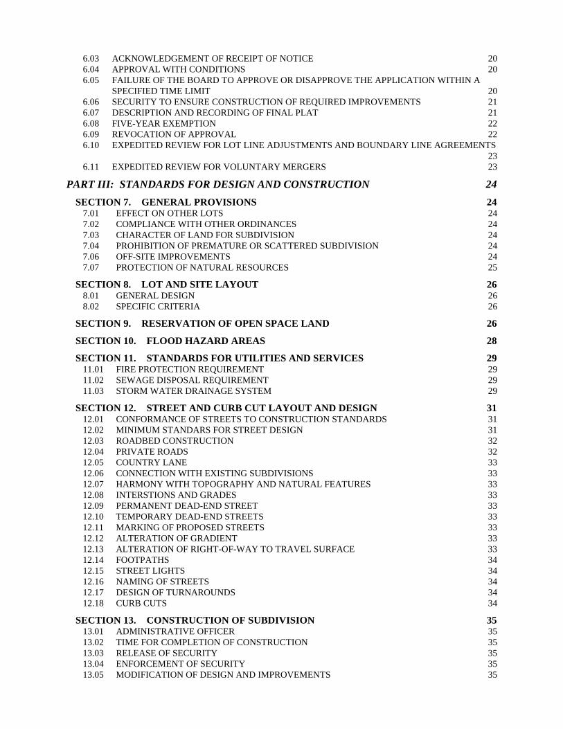
6.03 ACKNOWLEDGEMENT OF RECEIPT OF NOTICE 20 6.04 APPROVAL WITH CONDITIONS 20 6.05 FAILURE OF THE BOARD TO APPROVE OR DISAPPROVE THE APPLICATION WITHIN A SPECIFIED TIME LIMIT 20 6.06 SECURITY TO ENSURE CONSTRUCTION OF REQUIRED IMPROVEMENTS 21 6.07 DESCRIPTION AND RECORDING OF FINAL PLAT 21 6.08 FIVE-YEAR EXEMPTION 22 6.09 REVOCATION OF APPROVAL 22 6.10 EXPEDITED REVIEW FOR LOT LINE ADJUSTMENTS AND BOUNDARY LINE AGREEMENTS 23 6.11 EXPEDITED REVIEW FOR VOLUNTARY MERGERS 23
PART III: STANDARDS FOR DESIGN AND CONSTRUCTION 24 SECTION 7. GENERAL PROVISIONS 24
7.01 EFFECT ON OTHER LOTS 24 7.02 COMPLIANCE WITH OTHER ORDINANCES 24 7.03 CHARACTER OF LAND FOR SUBDIVISION 24 7.04 PROHIBITION OF PREMATURE OR SCATTERED SUBDIVISION 24 7.06 OFF-SITE IMPROVEMENTS 24 7.07 PROTECTION OF NATURAL RESOURCES 25
SECTION 8. LOT AND SITE LAYOUT 26 8.01 GENERAL DESIGN 26 8.02 SPECIFIC CRITERIA 26
SECTION 9. RESERVATION OF OPEN SPACE LAND 26
SECTION 10. FLOOD HAZARD AREAS 28
SECTION 11. STANDARDS FOR UTILITIES AND SERVICES 29 11.01 FIRE PROTECTION REQUIREMENT 29 11.02 SEWAGE DISPOSAL REQUIREMENT 29 11.03 STORM WATER DRAINAGE SYSTEM 29
SECTION 12. STREET AND CURB CUT LAYOUT AND DESIGN 31 12.01 CONFORMANCE OF STREETS TO CONSTRUCTION STANDARDS 31 12.02 MINIMUM STANDARS FOR STREET DESIGN 31 12.03 ROADBED CONSTRUCTION 32 12.04 PRIVATE ROADS 32 12.05 COUNTRY LANE 33 12.06 CONNECTION WITH EXISTING SUBDIVISIONS 33 12.07 HARMONY WITH TOPOGRAPHY AND NATURAL FEATURES 33 12.08 INTERSTIONS AND GRADES 33 12.09 PERMANENT DEAD-END STREET 33 12.10 TEMPORARY DEAD-END STREETS 33 12.11 MARKING OF PROPOSED STREETS 33 12.12 ALTERATION OF GRADIENT 33 12.13 ALTERATION OF RIGHT-OF-WAY TO TRAVEL SURFACE 33 12.14 FOOTPATHS 34 12.15 STREET LIGHTS 34 12.16 NAMING OF STREETS 34 12.17 DESIGN OF TURNAROUNDS 34 12.18 CURB CUTS 34
SECTION 13. CONSTRUCTION OF SUBDIVISION 35 13.01 ADMINISTRATIVE OFFICER 35 13.02 TIME FOR COMPLETION OF CONSTRUCTION 35 13.03 RELEASE OF SECURITY 35 13.04 ENFORCEMENT OF SECURITY 35 13.05 MODIFICATION OF DESIGN AND IMPROVEMENTS 35

13.06 INSPECTION OF CONSTRUCTION 35 13.07 CERTIFICATION OF COMPLIANCE 35 13.08 CORRECTION OF DEFICIENCIES 36 13.09 GUARANTEE OF INSTALLATION OF IMPROVEMENTS 36 13.10 DAMAGE TO ADJACENT PUBLIC AND PRIVATE PROPERTY, DRAINAGE FACILITIES, WATERWAYS, STREAMS, AND BROOKS 36 13.11 EROSION CONTROL AFTER CONSTRUCTION 36 13.12 MONUMENTS 36 13.13 CONVEYANCE OF EASEMENTS AND RIGHTS-OF WAY 37
APPENDIX FOR INFORMATIONAL PURPOSES - PUBLIC ROAD SYSTEM 38

Town of Orford – Subdivision Regulations – January 20, 2014
1
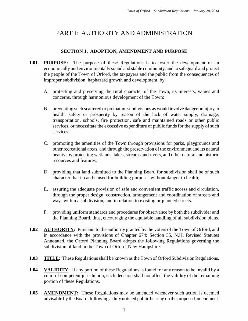
PART I: AUTHORITY AND ADMINISTRATION
SECTION 1. ADOPTION, AMENDMENT AND PURPOSE 1.01 PURPOSE: The purpose of these Regulations is to foster the development of an
economically and environmentally sound and stable community, and to safeguard and protect the people of the Town of Orford, the taxpayers and the public from the consequences of improper subdivision, haphazard growth and development, by:
A. protecting and preserving the rural character of the Town, its interests, values and
concerns, through harmonious development of the Town;
B. preventing such scattered or premature subdivisions as would involve danger or injury to health, safety or prosperity by reason of the lack of water supply, drainage, transportation, schools, fire protection, safe and maintained roads or other public services, or necessitate the excessive expenditure of public funds for the supply of such services;
C. promoting the amenities of the Town through provisions for parks, playgrounds and
other recreational areas, and through the preservation of the environment and its natural beauty, by protecting wetlands, lakes, streams and rivers, and other natural and historic resources and features;
D. providing that land submitted to the Planning Board for subdivision shall be of such
character that it can be used for building purposes without danger to health;
E. assuring the adequate provision of safe and convenient traffic access and circulation, through the proper design, construction, arrangement and coordination of streets and ways within a subdivision, and in relation to existing or planned streets.
F. providing uniform standards and procedures for observance by both the subdivider and
the Planning Board, thus, encouraging the equitable handling of all subdivision plans. 1.02 AUTHORITY: Pursuant to the authority granted by the voters of the Town of Orford, and
in accordance with the provisions of Chapter 674: Section 35, N.H. Revised Statutes Annotated, the Orford Planning Board adopts the following Regulations governing the subdivision of land in the Town of Orford, New Hampshire.
1.03 TITLE: These Regulations shall be known as the Town of Orford Subdivision Regulations. 1.04 VALIDITY: If any portion of these Regulations is found for any reason to be invalid by a
court of competent jurisdiction, such decision shall not affect the validity of the remaining portion of these Regulations.
1.05 AMENDMENT: These Regulations may be amended whenever such action is deemed
advisable by the Board, following a duly noticed public hearing on the proposed amendment.
Town of Orford – Subdivision Regulations – January 20, 2014
2
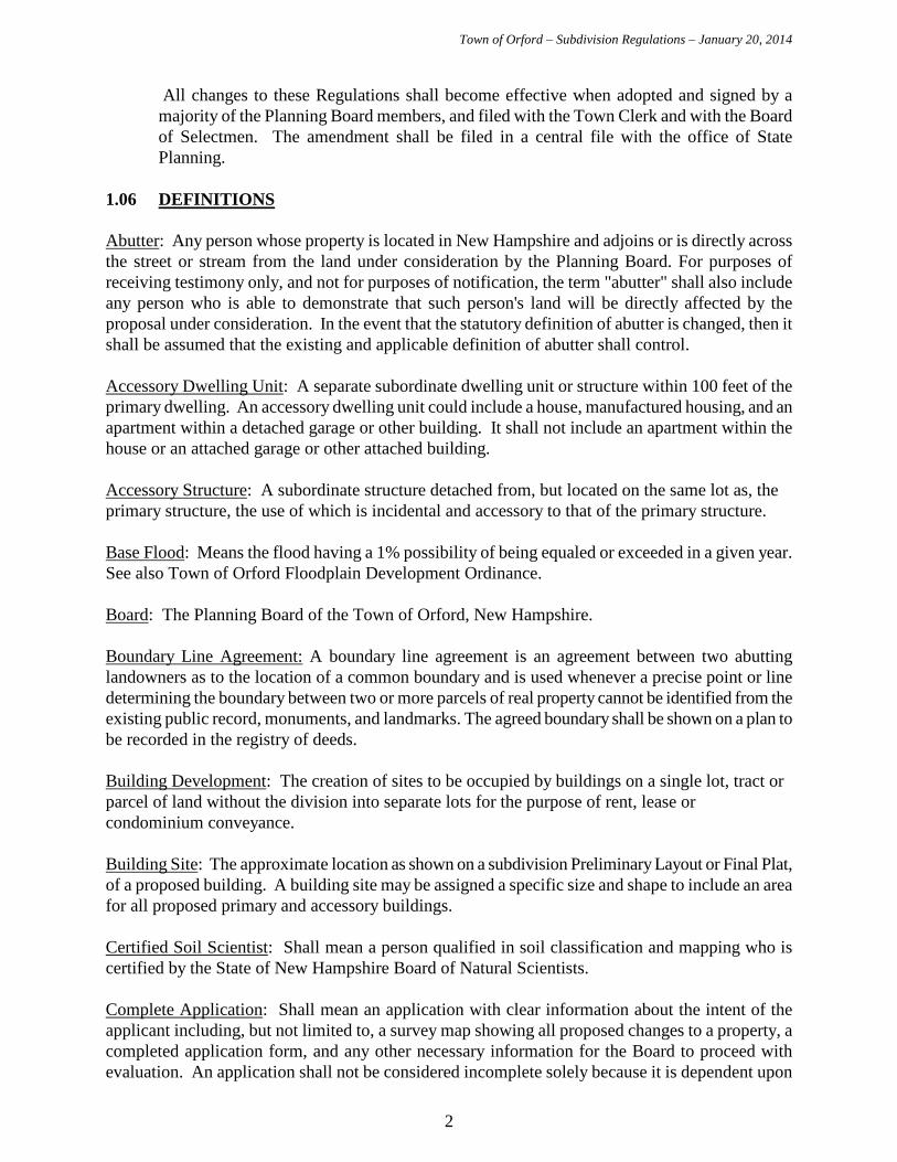
All changes to these Regulations shall become effective when adopted and signed by a majority of the Planning Board members, and filed with the Town Clerk and with the Board of Selectmen. The amendment shall be filed in a central file with the office of State Planning.
1.06 DEFINITIONS Abutter: Any person whose property is located in New Hampshire and adjoins or is directly across the street or stream from the land under consideration by the Planning Board. For purposes of receiving testimony only, and not for purposes of notification, the term "abutter" shall also include any person who is able to demonstrate that such person's land will be directly affected by the proposal under consideration. In the event that the statutory definition of abutter is changed, then it shall be assumed that the existing and applicable definition of abutter shall control. Accessory Dwelling Unit: A separate subordinate dwelling unit or structure within 100 feet of the primary dwelling. An accessory dwelling unit could include a house, manufactured housing, and an apartment within a detached garage or other building. It shall not include an apartment within the house or an attached garage or other attached building. Accessory Structure: A subordinate structure detached from, but located on the same lot as, the primary structure, the use of which is incidental and accessory to that of the primary structure. Base Flood: Means the flood having a 1% possibility of being equaled or exceeded in a given year. See also Town of Orford Floodplain Development Ordinance. Board: The Planning Board of the Town of Orford, New Hampshire. Boundary Line Agreement: A boundary line agreement is an agreement between two abutting landowners as to the location of a common boundary and is used whenever a precise point or line determining the boundary between two or more parcels of real property cannot be identified from the existing public record, monuments, and landmarks. The agreed boundary shall be shown on a plan to be recorded in the registry of deeds. Building Development: The creation of sites to be occupied by buildings on a single lot, tract or parcel of land without the division into separate lots for the purpose of rent, lease or condominium conveyance. Building Site: The approximate location as shown on a subdivision Preliminary Layout or Final Plat, of a proposed building. A building site may be assigned a specific size and shape to include an area for all proposed primary and accessory buildings. Certified Soil Scientist: Shall mean a person qualified in soil classification and mapping who is certified by the State of New Hampshire Board of Natural Scientists. Complete Application: Shall mean an application with clear information about the intent of the applicant including, but not limited to, a survey map showing all proposed changes to a property, a completed application form, and any other necessary information for the Board to proceed with evaluation. An application shall not be considered incomplete solely because it is dependent upon
Town of Orford – Subdivision Regulations – January 20, 2014
3
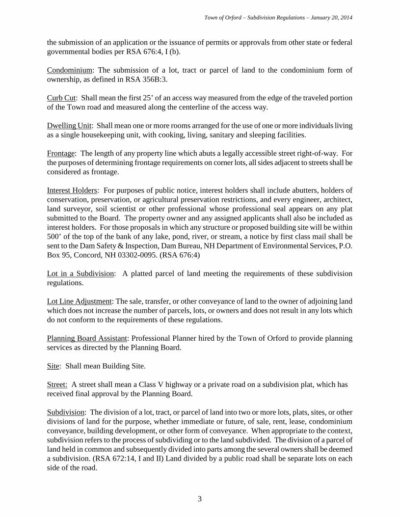
the submission of an application or the issuance of permits or approvals from other state or federal governmental bodies per RSA 676:4, I (b). Condominium: The submission of a lot, tract or parcel of land to the condominium form of ownership, as defined in RSA 356B:3. Curb Cut: Shall mean the first 25’ of an access way measured from the edge of the traveled portion of the Town road and measured along the centerline of the access way. Dwelling Unit: Shall mean one or more rooms arranged for the use of one or more individuals living as a single housekeeping unit, with cooking, living, sanitary and sleeping facilities. Frontage: The length of any property line which abuts a legally accessible street right-of-way. For the purposes of determining frontage requirements on corner lots, all sides adjacent to streets shall be considered as frontage. Interest Holders: For purposes of public notice, interest holders shall include abutters, holders of conservation, preservation, or agricultural preservation restrictions, and every engineer, architect, land surveyor, soil scientist or other professional whose professional seal appears on any plat submitted to the Board. The property owner and any assigned applicants shall also be included as interest holders. For those proposals in which any structure or proposed building site will be within 500’ of the top of the bank of any lake, pond, river, or stream, a notice by first class mail shall be sent to the Dam Safety & Inspection, Dam Bureau, NH Department of Environmental Services, P.O. Box 95, Concord, NH 03302-0095. (RSA 676:4) Lot in a Subdivision: A platted parcel of land meeting the requirements of these subdivision regulations. Lot Line Adjustment: The sale, transfer, or other conveyance of land to the owner of adjoining land which does not increase the number of parcels, lots, or owners and does not result in any lots which do not conform to the requirements of these regulations. Planning Board Assistant: Professional Planner hired by the Town of Orford to provide planning services as directed by the Planning Board. Site: Shall mean Building Site. Street: A street shall mean a Class V highway or a private road on a subdivision plat, which has received final approval by the Planning Board. Subdivision: The division of a lot, tract, or parcel of land into two or more lots, plats, sites, or other divisions of land for the purpose, whether immediate or future, of sale, rent, lease, condominium conveyance, building development, or other form of conveyance. When appropriate to the context, subdivision refers to the process of subdividing or to the land subdivided. The division of a parcel of land held in common and subsequently divided into parts among the several owners shall be deemed a subdivision. (RSA 672:14, I and II) Land divided by a public road shall be separate lots on each side of the road.
Town of Orford – Subdivision Regulations – January 20, 2014
4
Subordinate Structure: A structure typically dependent on the primary dwelling for sanitation, water, access and other relationships that are secondary to the primary dwelling. Not an independent dwelling unit. See “accessory dwelling unit” and “accessory structure.”
Voluntary Merger of Lots: The voluntary merger of two or more contiguous pre-existing approved or subdivided lots, which are all owned by the same person for the purposes of municipal regulation or taxation purposes. (RSA 674:39-a)
Town of Orford – Subdivision Regulations – January 20, 2014
5
SECTION 2. ADMINISTRATION AND ENFORCEMENT 2.01 APPLICATION OF REGULATIONS: These Subdivision Regulations shall be applied by
the Planning Board to any proposed subdivision. 2.02 APPROVAL REQUIRED BY PLANNING BOARD: All subdivision, lot line
adjustments, voluntary merger of lots and boundary line agreements as defined in these Regulations, in the Town of Orford require approval by the Planning Board in accordance with the Regulations.
A. Examples of What Needs Approval:
1. The division of a lot, tract, or parcel of land into two or more lots, which are to be
conveyed as separate lots to be owned individually.
2. The division of a lot, tract, or parcel of land into two or more sites for rent, lease, condominium conveyance, or building development.
3. The construction or placement of any additional separate dwelling units on a single
lot. 4. The development of condominium units whether they are in an existing or new
structure.
5. Lot line adjustments, boundary line agreements, and voluntary merger of lots.
2.03 APPLICATION OF MOST RESTRICTIVE REGULATIONS: Whenever the subdivision is subject to other restrictions contained in statutes, ordinances or other regulations, it is intended that the most restrictive regulations shall apply.
2.04 PROHIBITION OF CONSTRUCTION PRIOR TO APPROVAL: No person required
to obtain subdivision approval from the Planning Board shall commence the construction of roads or other improvements within the lot, tract, or parcel proposed to be subdivided by clearing the land of natural vegetation, placing any artificial fill thereon, or otherwise altering the land, unless the subdivision plan has been submitted and approved in accordance with the requirements of the Subdivision Regulations. This shall not be construed to prevent the taking of test borings, the digging of test pits, or any other testing and inspection necessary to comply with local or State requirements for review and approval.
2.05 PROHIBITION OF SALE PRIOR TO SIGNING AND RECORDING: No sale, transfer
or other conveyance of any part of a proposed subdivision shall be entered into by the property owner until an approved Final Plat has been signed by the Planning Board and recorded in the Grafton County Registry of Deeds. RSA 676:16.
2.06 ENFORCEMENT AND PENALTIES: These Regulations shall be enforced by the Board
of Selectmen, as provided in RSA 676:17. Enforcement of these Regulations shall follow the provisions of RSA 676:16 Penalties for Transferring Lots in Unapproved Subdivisions, and 676:17 Fines and Penalties.
Town of Orford – Subdivision Regulations – January 20, 2014
6
2.07 APPEALS: Any person aggrieved by a decision of the Board may appeal therefrom to the
Superior Court, as provided in RSA 677:15. 2.08 TIME LIMIT FOR COMPLETION OF IMPROVEMENTS: The time limit to complete
proposed improvements shall be determined by the Board on a case-by-case basis and written into the approval conditions. See also section 6.08 on vesting.
2.09 ACCEPTANCE OF DEDICATED STREETS: A street shown on an approved
subdivision plan constructed as required by the Planning Board, may be accepted only by action of the town meeting as provided in RSA 674:40, or pursuant to RSA 674:40-a if applicable.
Town of Orford – Subdivision Regulations – January 20, 2014
7
PART II: PROCEDURES AND SUBMISSION REQUIREMENTS
SECTION 3. TYPES OF APPLICATION REQUIRING PLANNING BOARD APPROVAL
3.01 LOT LINE ADJUSTMENTS AND BOUNDARY AGREEMENTS: Lot line
adjustments or boundary agreements require the approval of the Planning Board to make certain that no new or non-conforming lots have been created. Lot line adjustments include an exchange of land or moving the common boundary between two abutting lots where no new lots are created. A boundary agreement is an agreement between two abutting landowners as to the location of a common boundary, which is shown on a plan to be recorded in the registry of deeds. No public hearing is required for boundary agreements, but abutters must be notified 10 days prior to the meeting to review the approval applications and abutters may be heard upon request per RSA 676:4 I. (e) (1).
3.02 MINOR SUBDIVISION: A minor subdivision is any subdivision resulting in no more than
three (3) lots or sites, each with Planning Board approved access to an existing, publicly maintained street, and not involving any public improvement.
A parcel of land, which has been subjected to minor subdivision, shall not be eligible for further subdivision under the Minor Subdivision procedures for a period of ten (10) years from the date of the most recent minor subdivision approval. Any further subdivision within ten (10) years is subject to major subdivision Regulations.
If, in the judgment of the Board, the subdivision as initially presented does not meet the requirements for a Minor Subdivision as stated in the Definition, the Board may require a subdivision to be processed as a Major Subdivision.
3.03 MAJOR SUBDIVISION: A Major Subdivision is any subdivision which results in four or
more lots or sites, or that requires new streets or public improvements. Major Subdivision also includes re-subdivision of a lot subdivided under the Minor Subdivision procedures within the previous ten years.
3.04 VOLUNTARY MERGER OF LOTS: Any owner of two or more contiguous pre-existing
approved or subdivided lots or parcels, who wishes to merge them for municipal regulation and taxation purposes may do so by applying to the Planning Board. Except where such merger would create a violation of then current ordinances or regulations, all such requests shall be approved, and no public hearing or notice shall be required. No new survey plat need be recorded, a notice of merger containing a description of the two lots merged into one lot including tax map and lot number and signed by the Planning Board shall be filed in the Grafton County Registry of Deeds under the name of the owner or owners as grantors and a copy shall be attached to the Town's tax assessing card. Any subdivision of the merged lot shall require subdivision approval.
3.05 EXEMPTION FOR ACCESSORY DWELLING UNIT:
This section is provided to allow accessory dwelling units without a subdivision as defined in
Town of Orford – Subdivision Regulations – January 20, 2014
8
NH RSA 672:14. . The construction or addition of one accessory dwelling unit on the same lot as a primary house or manufactured housing unit may be approved by the Planning Board. Such approval shall not constitute an approved subdivision for any purpose including, but not limited to, taxation. The landowner shall comply with all applicable rules and regulations of the New Hampshire Department of Environmental Services relating to water supply and subsurface disposal systems. A. The following conditions shall be part of every exemption:
a. Landowner Signs for Notice of Exemption: The Landowner shall acknowledge and sign a receipt of the notice of exemption and agrees to be bound by the terms and conditions of the exemption before the exemption becomes effective. The Town shall record the signed and Planning Board approved Notice of Exemption at the Grafton County Registry of Deeds under the name of the landowner or grantor as notice for any transfer of the property.
b. Future Subdivision: In the event of a subdivision of the lot in the future, the proposed division of the lot shall comply with the Subdivision Regulations in effect at the time. If a lot containing two dwelling units for which an exemption has been granted cannot comply with the Subdivision Regulations, including the separation of the two dwelling units, each onto a separate lot which complies with the Subdivision Regulation, then subdivision approval may be denied and the two dwelling units shall continue to be owned by one owner on one lot.
c. Taxation: A copy of the notice of exemption shall be furnished to the Board of Selectmen to be attached to the tax record for the lot. There shall be noted on the tax record that there can be no conveyance of individual dwelling units without subdivision approval from the Planning Board. If one of the dwelling units is moved from the lot or destroyed, dismantled or otherwise rendered uninhabitable, the landowner shall inform the Selectmen and the Planning Board in writing and, upon verification, the Planning Board shall issue to the landowner a cancellation of the exemption to be recorded in the Grafton County Registry of Deeds and cross-referenced to the notice of exemption.
d. Loss or Destruction: If one of the dwelling units is destroyed by fire, flood or other casualty, that dwelling unit can be replaced on the same site. In the event of such destruction and intent to rebuild, the landowner shall provide sufficient information to the Planning Board so that the Board may determine that this condition is met.
e. Violation: If the Town is required to take legal action upon any expiration of the exemption or violation of the exemption, the landowner shall reimburse the Town for all legal expenses incurred and the costs, if any.
Town of Orford – Subdivision Regulations – January 20, 2014
9
SECTION 4. APPLICATION PROCEDURES 4.01 TIME FOR FILING AN APPLICATION FOR SUBDIVISION APPROVAL: All applications to the Planning Board for subdivision approval shall be filed with the Planning Board or its designated agent on the appropriate form as approved by the Planning Board, at least eighteen (18) days before the regularly scheduled meeting at which formal application is to be made to the Board. 4.02 PUBLIC NOTICE: When Notice is required in the Regulations, the Board shall give Notice as follows:
A. a copy of the Notice shall be sent by certified mail to the abutters, the applicant, and any engineer, architect, land surveyor or soils scientist whose professional seal appears on any plat submitted to the Planning Board interest holders at least ten (10) days prior to the public meeting/hearing. For the purposes of these Regulations, in counting days, the day on which Notice is given and the day of the public meeting/hearing shall be excluded;
B. notice to the general public shall be given by one publication of a copy of the Notice in
the Valley News or such other paper as may be designated by the Planning Board, at least ten days prior to the public meeting/hearing. At the same time, the Board shall post copies of the Notice in two public places in Town;
C. the notice must include a general description of the proposal, which is the subject of the application and shall identify the applicant and the location of the proposal. The notice should also indicate the date, time and place of the public hearing or whatever is the subject of the notice.
D. additional notice of an adjourned session of a public meeting/hearing is not required if
the date, time and place of the adjourned session is made known at the prior meeting/hearing;
E. the applicant shall pay, in advance, all costs of Notice. Failure to pay costs may be the
basis for disapproval of the application.
4.03 ADDITIONAL NOTICE REQUIREMENTS FOR DEVELOPMENTS OF
REGIONAL IMPACT: Upon receipt of an application for subdivision, the Planning Board shall review it and determine whether or not the development, if approved, could reasonably be construed as having the potential for impact beyond the boundaries of Orford. This regional impact could result from a number of factors, such as, but not limited to, the following:
A. relative size or number of lots or units compared with existing stock;
B. transportation networks;
C. proximity to the borders of a neighboring community;
Town of Orford – Subdivision Regulations – January 20, 2014
10
D. anticipated emissions such as light, noise, smoke, odors or particles; E. proximity to aquifers or surface waters which transcend municipal boundaries; and
F. shared facilities such as schools and solid waste disposal facilities.
Doubt concerning regional impact shall be resolved in a determination that the development has a potential regional impact. Upon determination that a proposed development has a potential regional impact, the Planning Board shall afford the Regional Planning Commission and the affected municipalities the status of abutters for the limited purpose of providing notice and giving testimony. Within 72 hours of not more than 5 business days (RSA 36:57) after reaching a decision that a development has regional impact, the Planning Board shall, by certified mail, furnish the Regional Planning Commission and the affected municipalities with copies of the minutes of the meeting at which the decision was made. At least fourteen (14) days prior to the public hearing, the Planning Board shall notify, by certified mail, all affected municipalities and the Regional Planning Commission of the date, time and place of the hearing and the right to testify concerning the development.
4.04 APPLICATION FEES, ADMINISTRATIVE EXPENSES, AND OTHER COSTS
INCURRED BY THE TOWN AND THE BOARD: The applicant shall pay the application fees according to the Schedule of Fees adopted by the Planning Board. In addition, the Board may require the applicant to pay additional reasonable fees to cover its administrative expenses and costs of special investigative studies, review of documents, and other matters which may be required by particular application (RSA 676:4 I (g)). Such additional fees may also include an appropriate allocation of legal fees incurred by the Board.
4.05 APPLICATION STEPS: The Orford Planning Board encourages applicants to take
advantage of the Informal Preliminary Consultation and the Preliminary Design Plan steps of the application process. It may be in the best interest of the applicant, as well as the Planning Board, to discuss the proposed subdivision, lot line adjustment or boundary line agreement on an informal basis prior to actual submission of the application. Preliminary review may be required by the Planning Board for a complex application.
A. INFORMAL PRELIMINARY CONSULTATION (NH RSA 676:4 II. (a))
1. PROCEDURE: If the applicant so requests, the Planning Board shall place on its
agenda for a regularly scheduled meeting an Informal Preliminary Consultation between the applicant and the Board. Such consultation shall not bind either the applicant or the Board. There is no application fee for this phase. This phase in the review process is optional for the applicant, and is made available by the Board in order to save expense and unnecessary changes later on. The Board encourages the applicant to meet with the Planning Board Assistant at this phase, and to meet with the Planning Board only if the applicant so desires.
2. INFORMATION REQUESTED: The applicant should provide the Board with a
sketch plan or recorded survey map showing the location and type of the proposed development, with additional information, such as general topography, including
Town of Orford – Subdivision Regulations – January 20, 2014
11
prominent natural features of the tract, and, if applicable, how the concept conforms to the Master Plan. The Planning Board will review a sketch, tax map, or recorded survey. However, the Board shall not review any unrecorded survey during this process without a publicly noticed meeting or hearing.
3. NO ACTION OF THE BOARD: The Informal Preliminary Consultation between
the applicant and the Board shall be limited to a discussion as to concept and in general terms for the limited purpose of familiarizing the Board with the location and type of development, and the applicant with general requirements of the Board, as set forth in the Regulations. Following the Informal Preliminary Consultation, and after determining the general character of the proposed subdivision, the Board shall advise the applicant concerning subsequent procedures and submission requirements.
B. PRELIMINARY DESIGN PLAN (NH RSA 676:4 II. (b))
1. PROCEDURE: The applicant may submit to the Planning Board for review a
Preliminary Plan of the proposed subdivision. A completed preliminary application for subdivision approval shall be submitted to the Planning Board or its designated agent at least eighteen (18) days before the meeting at which said application is to be reviewed and determined if complete. The Board shall give formal public notice, at the applicant's expense, to abutters and the general public of the Preliminary Plan review, as required under RSA 676:4, I (b). The review of the Preliminary Plan shall be conducted only at formal meetings of the Board. The Board may review the proposal in detail and receive testimony in person or in writing from any applicant, any abutter, or any other person as permitted by the Board. This phase in the subdivision review process is optional, except as noted above, for the applicant and is made available by the Board in order to save expense and changes later on. This phase is especially valuable for complicated applications.
2. INFORMATION REQUESTED: Preliminary plans should show substantially the
same information described in Section 5: Requirements for a Completed Application for Final Subdivision Approval, and be provided in five (5) copies. However, dimensions may be approximate and data may be tentative. The preliminary plans should be sufficiently clear to establish the basis of and to clarify the design requirements for the subdivision Final Plat including a site location map, a site survey showing pertinent features of the site, an indication of any future subdivisions contemplated in or adjacent to the proposal, a topographic map of the area; any soils information such as permeability or boring data that has been gathered; and a sketch showing the proposed layout of lots, streets, recreation areas, watercourses, natural features, and easements. Maps shall be at a scale of no more than 100 feet per inch, unless an exception is granted by the Board or its agent.
3. NO ACTION OF THE BOARD: Upon receipt of the Preliminary Plan, the Board
shall give Notice of the meeting at which the plans will be reviewed. During this review phase, the applicant may be alerted to site problems that can be resolved or mitigated before the final plans are submitted. Such preliminary review shall bind
Town of Orford – Subdivision Regulations – January 20, 2014
12
neither the applicant nor the Board. At a public meeting, the board may determine that the preliminary plan review period is over and shall inform the applicant in writing within 10 days of such determination.
C. FINAL APPLICATION
1. PROCEDURE: A completed final application for subdivision approval shall be submitted to the Planning Board or its designated agent at least eighteen (18) days before the meeting at which said application is to be reviewed and determined if complete.
2. REQUIREMENTS FOR A COMPLETED APPLICATION (RSA 676:4, I (b)): A
completed final application shall contain all of the applicable items described in Section 5: Requirements for a Completed Application for Final Subdivision Approval of these regulations.
3. ACTION OF THE BOARD: The Board shall, at a public meeting for which notice
has been given, review the application for completeness, as required by these Regulations. If determined to be complete, and all required fees and costs of notice have been paid, then the Board shall, by motion, accept the application as complete relative to jurisdiction of the Board per RSA 674:4, I (b).
If the Board finds the application to be incomplete, the applicant shall be notified of the deficiencies in writing. The Board may reject an application with no further action based upon failure to supply information required by the Regulations, failure to meet reasonable deadlines established by the Board, or failure to pay cost of notice or other fees required by the Board.
Town of Orford – Subdivision Regulations – January 20, 2014
13
SECTION 5. REQUIREMENTS FOR A COMPLETED APPLICATION FOR FINAL SUBDIVISION APPROVAL
5.01 GENERAL REQUIREMENTS: A completed application for subdivision approval shall
include:
A. a completed application form;
B. a list of the names and addresses of all the interest holders (see definition) including abutters indicated in the Town records not more than five days before the day of submittal;
C. application fees and costs of notice; D. written waiver requests per section 5.13 to relax the requirements in a specific section of
these regulations including justification for each request; and
E. five copies of each required map and application documents.
5.02 MAP DOCUMENTATION: All of the required maps shall be drawn at a scale no smaller than 100 feet per inch, unless a waiver is granted by the Board under section 5.13. All maps shall be prepared, signed, and sealed by a N.H. Licensed Land Surveyor and shall include:
A. the name of municipality and subdivision;
B. the name and address of the property owner and the surveyor;
C. the tax map and lot number of the land proposed to be subdivided;
D. north point, bar scale, date of preparation and dates of all revisions;
E. any existing or proposed easements forming part of the subdivision proposal;
F. any deed restrictions impacting the subdivision proposal; and G. the following statement: "The Subdivision Regulations of the Town of Orford are a part
of the Plat, and approval of this Plat requires the completion of all the requirements of the Subdivision Regulations excepting only any relaxation of requirements granted by the Planning Board and written into their meeting minutes."
Maps may be combined when, in the judgment of the Board or its agent, the resulting map will be clear enough for review.
5.03 SURVEY: (Plat to be recorded if approved.) The survey is required for all applications and
shall show the following information:
A. general site location map locating the subdivision boundary in relation to major roads or other features shown on the Town map;
Town of Orford – Subdivision Regulations – January 20, 2014
14
B. names of abutters;
C. boundaries and area of the entire parcel whether or not all land therein is to be
subdivided, referenced to a public street, intersection or USGS benchmark. In the case of a minor subdivision, the Board may waive the requirement of a perimeter survey for the entire parcel and may require specific data only for the portion of the parcel to be subdivided. In such instances, the map shall include an inset, which shows the location of the detail area relative to the entire parcel;
D. lot lines, existing buildings, streets and driveways within 200 feet of the parcel to be
subdivided;
E. location and type of all proposed and existing survey monuments;
F. existing and proposed lot lines, bearings and dimensions, lot sizes in square feet or acres, consecutive numbering of lots using the town’s tax map system, monuments at lot corners;
G. existing and proposed street right of way lines;
H. location of existing or proposed parks and other open space; I. location of driveway access to each lot;
J. location of existing and proposed wells and on-site sewage disposal systems; and
K. base flood elevations as defined in the Town of Orford Floodplain Development
Ordinance if any portion of the property is designated within a special flood zone. 5.04 TOPOGRAPHIC MAP: The topographic map is required for all applications except
applications for voluntary mergers, boundary line agreements, and lot line adjustments and shall show:
A. existing topography and proposed changes in topography. Actual contours shall be
shown at intervals of not more than 10 feet. Intervals of less than 10 feet may be required for part or all of the parcel depending on the character of the topography. Interpolations of USGS maps may be used unless the Board requires actual contours; and
B. significant natural features such as rock outcrops, surface water and wet areas.
5.05 SOILS MAP AND REPORT: The soils map and report shall be required only for minor
and major subdivisions, and shall include the following:
A. location of all percolation test sites and soil test pits or borings. At least one percolation test site, soil test pit, or boring per lot or site.
Town of Orford – Subdivision Regulations – January 20, 2014
15
B. soil mapping units and boundaries based on the most recent Natural Resources Conservation Service mapping available;
C. legend identifying soil mapping unit symbols and soil type names; and
D. the soils map shall be accompanied by a report of the results of all soil tests including
dates, locations by reference to the map, percolation rates, and soil profile with depth to ledge, clay, hardpan, and existing and seasonal high water table. The soils report shall also include an analysis by a NH licensed soils scientist or engineer regarding the suitability of the soils for the proposed development.
5.06 UTILITIES AND FIRE PROTECTION PLAN: The utilities and fire protection plan is
required for major subdivisions only and shall include the following: A. show location and details of all existing and proposed utilities, such as electric and
telephone; and
B. show and describe fire protection measures to be provided. Refer to Section 11 for Design Standards.
5.07 STORM WATER MANAGEMENT AND SEDIMENT CONTROL PLAN:
PURPOSE: The purpose of this section is to control soil erosion and to prevent the resulting sedimentation from occurring in the subdivision areas by requiring proper provision for water disposal and protection of soil surfaces during and after construction, in order to promote the public health, safety, convenience, and general welfare of the community.
A. Conditions Requiring a Plan: A storm water management and erosion and sediment
control plan shall be submitted to the Planning Board for any tract of land being developed or subdivided, where one or more of the following conditions are proposed: 1. any subdivision that might alter the flow of water over adjacent lots; 2. construction of any street or road; or
3. developments in erosion prone areas.
B. Plan Requirements: The grading and drainage plan shall include the following:
1. show detail of all existing and proposed drainage facilities on and within 200 feet of
the subdivision, including drainage ditches, drainage swales, storm drainage lines and storm water retention basins. Show the final identification, location, elevation, grades, profiles, and contours at not more than 10 foot intervals for the existing and proposed drainage ways and structures. Intervals less than 10 feet may be required depending on the character of the topography;
2. computations of quantity and rate of runoff before and after completion of the

Town of Orford – Subdivision Regulations – January 20, 2014
16
subdivision for a ten (10) year and twenty-five (25) year 24 hour storm event;
3. computation of storm water drainage capacity based on the estimated runoff, including impact on downstream drainage structures; and
4. show and describe proposed soil erosion and sediment control measures and
structures relative to construction activities and final stabilization.
Refer to Section 11.03 for Design Standards 5.08 ROAD PLAN: The road plan is required for major subdivisions only and shall include the
following:
A. show existing and proposed street right of way lines, widths of streets, proposed names of new streets, dimensions of tangents, chords, and radii, location of all monuments to be set at street intersections, points of curvature and tangency of curved streets and angles of lots;
B. profiles shall be provided of all proposed streets showing existing and proposed
elevations along the centerlines and proposed grades;
C. cross sections shall be provided of all proposed streets at reasonable intervals and at all catch basins, bridges or culverts; and
D. construction details of all roadways, curbing and walkways shall be shown. See Section
12 for layout and design requirements. 5.09 ADDITIONAL DOCUMENTS REQUIRED PRIOR TO SIGNING AND FILING OF
PLAT: Where applicable to a specific subdivision, the following documents shall be submitted prior to signing and recording the final plat:
A. agreement to convey to the Town land to be used for streets, open space and other public
purposes, with transfer of title to such interests to be effective on such date as the Town accepts such land;
B. easements and right of way over property to remain in private ownership; and
C. maintenance agreement(s) when a driveway and/or subdivision road is to serve more
than one lot. D. rights to drain onto or across other property, whether public or private, including a street.
E. any permits required by any federal, state, or Town agency having jurisdiction over any
aspect of the proposed subdivision shall be submitted prior to final subdivision approval. These may include the following:
1. N.H. DES Wetlands Bureau Dredge and Fill Permit;
Town of Orford – Subdivision Regulations – January 20, 2014
17
2. N.H. DES Alteration of Terrain Bureau Application for significant alteration of terrain (over 100,000 square feet of disturbed area or over 50,000 square feet if any disturbance is within the protected shoreline as defined by RSA 483-B);
3. N.H. DES Subsurface Systems Bureau Application for Subdivision Approval;
4. driveway permit from N.H. DOT or curb cut permit from the Planning Board;
5. Personal Wireless Service Facilities Conditional Use Permit from the Planning Board;
6. all required permits per Shoreland Water Quality Protection Act from N.H. DES;
7. Floodplain Development Permit from the Board of Selectmen after Orford Zoning
Board of Adjustment approval;
8. National Pollutant Discharge Elimination System Federal Stormwater Program (Phase II) Construction General Permit from U.S. EPA.
All required permits must be obtained prior to signing and filing of the final plat.
5.10 ADDITIONAL INFORMATION MAY BE REQUIRED: In the case of either a minor or
a major subdivision, the Board may require such additional information to be provided, at the applicant’s expense, as it deems necessary, to evaluate the proposed subdivision in relation to the purposes and scope of these Regulations.
Such additional information may include, but not be limited to, a study of the availability and impact on community services, facilities, wildlife habitat and natural resources.
5.11 SECURITY FROM THE SUBDIVIDER FOR COMPLETION OF IMPROVEMENTS
REQUIRED BY THE PLANNING BOARD: If, after review of an application the Planning Board requires that the applicant furnish security (RSA 674:36 III.(b)), the Planning Board will determine the estimated cost of the improvements at the expense of the applicant, and the applicant will provide security using one of the following financial instruments as approved by the Town’s legal counsel: - (see also Section 6.06)
A. performance bond B. irrevocable letter of credit C. escrow account agreement. After security has been posted, the final plat can be signed and recorded. The deadline for performance shall be coordinated with the expiration of the performance bond or letter of credit including additional time to allow for inspection by the Town or its representatives. If necessary, the applicant will be responsible for renewing the security to extend to the installation of improvements; otherwise, the Planning Board may revoke the approval (RSA 676:4-a, I(e)).
Town of Orford – Subdivision Regulations – January 20, 2014
18
In the event that the applicant, after receiving final approval and before recording the final plat, chooses to complete the improvements without posting security, the Town’s engineer will, at the applicant’s expense, inspect the improvements. If acceptable to the Planning Board the Plat can be signed and recorded. Regardless of the amount of the security, the applicant shall be responsible for the actual cost for the completion of the improvements required by the Planning Board in the event of default and the balance of the work is done by the Town or its agents. If the applicant does not pay the additional amounts upon request by the Town, the Town shall take legal action as may be necessary, and if the Town prevails, the court shall award the Town reasonable attorneys' fees.
5.12 MARKING OF LOTS: At the earliest practical stage during the application, the applicant
shall place on the ground clearly observable survey stakes or ribbons marking the corners of all proposed lots or sites.
5.13 WAIVER REQUESTS: Upon the written request by the applicant, the Board may grant a
waiver or relaxation of the provisions of the Regulations as it deems appropriate per NH RSA 674:36 II (n), by majority vote of the Board. Reasons for the waiver shall be recorded in the meeting minutes. The requirements of these regulations may only be modified or waived by the Board when : 1.) Strict conformity would pose an unnecessary hardship to the applicant and a waiver would not be contrary to the spirit and intent of the regulations; or 2.) Specific circumstances relative to the subdivision, or conditions of the land in such subdivision, indicate that the waiver will properly carry out the spirit and intent of the regulations.
Town of Orford – Subdivision Regulations – January 20, 2014
19
SECTION 6. PLANNING BOARD REVIEW OF FINAL APPLICATIONS 6.01 CONSIDERATION AND ACTION ON FINAL PLAT:
A. After delivery of an application and with proper notice, the Board shall determine if
the application is complete at its next regular Board meeting or within 30 days. (See definition of “Complete Application.”) The Board shall act to approve, approve with conditions, or disapprove the application within sixty-five (65) days of the date of acceptance of this application. At least one public hearing shall be held on an application prior to action by the Board.
B. The Board may apply to the Board of Selectmen, prior to the expiration of the sixty-
five (65) day period for an extension of time not to exceed ninety (90) additional days before acting to approve or disapprove the application, or the applicant may consent to an extension of time for the Board to act provided that such consent shall be in writing. Failure to make a decision within the prescribed time will result in procedures to be followed in RSA 676:4 as shown in section 6.05.
6.02 NOTICE OF ACTION ON THE FINAL PLAT: The Board shall notify the applicant in
writing of its actions on the Final Plat. In case of disapproval, the grounds for such disapproval shall be set forth in the Notice of Action, which shall become part of the records of the Board. For the purpose of calculating the 30 day period within which to file an appeal under RSA 677:15, the 30 day period will begin with the date on which the Notice of Action has been signed by the Chairman of the Board. In case of approval, the Notice of Action shall set forth the following:
A. a copy of any deed restriction submitted by the applicant and accepted by the Board.
Deed restrictions shall be written on the Final Plat; B. any precedent conditions required by the Board prior to signing the final plat; C. any subsequent conditions that must appear on the final plat and deal with restrictions
on the use of property or safeguards that must be observed during development of the property or once the project is in use.
D. all requirements for off-site improvements; E. a description of land, if any, to be dedicated to widen existing streets; F. a description of any modification or waiver of design standards G. when applicable, the statement described in Section 9.F. concerning liability for
public use of land; H. all agreements, if any, between the applicant and the Board concerning matters not
required by these Regulations, but to be performed by the applicant;
Town of Orford – Subdivision Regulations – January 20, 2014
20
I. a statement that the Subdivision shall be completed and constructed in conformity with the Final Plat and the Regulations; and
J. a reference to any surety to be provided by the applicant as guarantee of performance
in construction of the subdivision, as set forth in Section 6.06. 6.03 ACKNOWLEDGEMENT OF RECEIPT OF NOTICE: The applicant shall acknowledge
receipt of the Notice and acceptance of all provisions set forth therein, and shall return a signed copy of it to the Board for its records. Until such acknowledgment and acceptance has been filed with the Board, no further action shall be taken with regard to the Final Plat. Failure to acknowledge receipt of Notice of Action and acceptance within ninety (90) days of mailing of the Notice of Action will cause approval to lapse.
6.04 APPROVAL WITH CONDITIONS: Conditional approval may become final without
further public hearing when conditions are:
A. minor plan changes, whether or not imposed by the Board as a result of a public hearing, compliance with which is administrative and does not involve discretionary judgment;
B. conditions which are in themselves administrative and which involve no
discretionary judgment on the part of the Board; or
C. conditions with regard to the applicant's possession of permits and approvals granted by other boards or agencies.
Conditional approval may be revoked per RSA 676:4-a. I. (c) if the applicant shall not comply with all of the requirements set forth in the notice of action and shall lapse if the final plat is not recorded in the Registry of Deeds within 3 years or as extended with approval of the Planning Board. Approval of Final Plat shall lapse if such Plat is not recorded in the Registry of Deeds within three years from the date of acknowledgment and acceptance of the Notice of Action unless the Planning Board extends the time.
6.05 FAILURE OF THE BOARD TO APPROVE OR DISAPPROVE THE APPLICATION
WITHIN THE SPECIFIED TIME LIMIT: The applicant, upon the failure of the Board to approve, conditionally approve or disapprove of the application within the time specified in section 6.01, may obtain from the Selectmen an order directing the Board to act within thirty (30) days. If the Board does not act on the application within that 30 day time period, then within forty (40) days of the issuance of the order, the Selectmen shall certify on the applicant's application that the plat is approved pursuant to RSA 676:4.I(c)(1), unless within those 40 days the Selectmen have identified, in writing, some specific Subdivision Regulation or other ordinance provision with which the application does not comply. Such a certification shall constitute final approval for all purposes, including filing, recording and court review.
Failure of the Selectmen to issue an order to the Planning Board, or to certify approval of the plat upon the Planning Board's failure to comply with the order, shall constitute grounds for the superior court, upon petition of the applicant, to issue an order approving the application
Town of Orford – Subdivision Regulations – January 20, 2014
21
if the court determines that the proposal complies with existing regulations. If the court determines that the failure of the Selectmen to act was not justified, the court may order the municipality to pay the applicant's reasonable costs, including attorney's fees, incurred in securing such order.
6.06 SECURITY TO ENSURE CONSTRUCTION OF REQUIRED IMPROVEMENTS: In
the event the applicant desires to obtain an endorsement on the final plat and the recording of the plat in the Registry of Deeds in order to sell lots in the approved subdivision prior to the construction of the improvements, the applicant may request the Planning Board to accept security in lieu of the completion of the improvements. The applicant shall furnish to the Town a performance bond or irrevocable letter of credit or escrow agreement in an amount as determined by the Planning Board, in a form as approved by the Board of Selectmen and the
Town Attorney. A real estate mortgage is not acceptable as security. The security shall secure the performance of all the terms and conditions of the Notice of Action within three (3) years from the date of acknowledgment and acceptance of the Notice of Action. Regardless of the amount of the security, the applicant shall be responsible for and shall pay the actual cost of the construction and installation of all improvements. If the applicant has not complied with the Notice of Action within the three (3) year period, the Town shall enforce its rights under the security. In the event the Town is required to incur legal expenses, the Town shall be entitled to have reasonable attorneys fees paid by the applicant and if court action,
awarded by the court. 6.07 DESCRIPTION AND RECORDING OF FINAL PLAT:
A. Following approval, the applicant shall submit to the Board one Mylar master in permanent black ink and two paper prints of the approved final plat. Mylars shall be in accordance with the requirements of the Grafton County Register of Deeds. Space shall be reserved on the Plat for signing by the Board, and shall include any required language as noted on the subdivision application form or as required by the Planning Board.
B. In the event the Planning Board accepts security as defined in Section 5.11, the final plat
shall be signed by the Board at the time of final approval and registered at the Grafton County Registry of Deeds.
C. In the event that construction of required improvements is not secured as provided in
section 5.11, construction of improvements shall be fully completed in accordance with the final plat, notice of action, and these Regulations prior to signing by the Board and filing of the plat with the Grafton County Registry of Deeds. No lots shall be conveyed, leased or rented until the plat is filed.
D. Following signing, the Board shall cause the Mylar plat to be recorded in the Grafton
County Registry of Deeds, and shall deliver two paper copies to the Town for its records. All graphic material and presentations shall be on the surface of the Mylar Plat. The act of recording an approved subdivision plat shall not in itself constitute acceptance by the Town of any street or easement shown thereon and roads shall be labeled as “private,” where applicable.
Town of Orford – Subdivision Regulations – January 20, 2014
22
6.08 FIVE-YEAR EXEMPTION: Every plat approved by the Board and recorded in the Registry of Deeds shall be exempt from all subsequent changes in subdivision regulations and other local land use ordinances and regulations, except those which expressly protect public health, such as water quality and sewage treatment requirements, for a period of five years after the date of approval, provided, however, that:
A. active and substantial development or building has begun on the site by the owner or his
successor in interest in accordance with the approved plat within 24 months after the date of approval, or in accordance with the terms of said approval, and, if a bond or other security to cover the costs of roads, drains or sewers is required in connection with such approval, such bond or other security is posted with the Town at the time of commencement of such development (RSA 674:39, I.);
B. development remains in full compliance with the public health regulations and ordinances specified in this section; and
C. at the time of approval and recording, the plat conforms to the subdivision regulations then in effect.
Substantial completion of improvements shown on the plat shall be fifty percent (50%) of the proposed work or as determined by the planning board, with due regard to the scope and details of a particular project, specify the threshold level of work which shall constitute active and substantial development or building for purposes of fulfilling Section 6.08 A of this section, or may, for good cause extend the 24-month period set forth in Section 6.08 A. Once substantial completion of the improvements have occurred in compliance with the approved plat, or the terms of said approval, the rights of the owner or his/her successor in interest shall vest and no subsequent changes in subdivision regulations or other land use regulations shall operate to affect such improvements (RSA 674:39).
6.09 REVOCATION OF APPROVAL: A subdivision plat which has been filed with the
Register of Deeds may not be revoked in whole or in part, by the Planning Board, except pursuant to RSA 676:4-a, and only under the following circumstances:
A. at the request of, or by agreement with, the applicant or the applicant's successor in
interest;
B. when the applicant or successor in interest to the applicant has performed work, erected a structure or structures, or established a use of land, which fails to conform to the statements, plans or specifications upon which the approval was based, or has materially violated any requirement or condition of such approval;
C. when the applicant or successor in interest to the applicant has failed to perform any
condition of the approval within a reasonable time specified in the approval, or if no such time is specified, within the time period otherwise specified in these regulations (see section 6.06).
D. when the time periods specified have elapsed without any vesting of rights as set forth
herein, and the plat no longer conforms to applicable ordinances and regulations (see section 6.08); or
Town of Orford – Subdivision Regulations – January 20, 2014
23
E. when the applicant or successor in interest to the applicant has failed to provide for the
continuation of adequate security until such time as the work secured thereby has been completed (see section 5.11).
The Board shall hold a duly noticed public hearing prior to revocation of approval.
6.10 EXPEDITED REVIEW FOR LOT LINE ADJUSTMENTS AND BOUNDARY LINE
AGREEMENTS:
A. Notice is required.
B. Any abutter may be heard on the application for review at the public meeting when the matter is discussed by the Board. If deemed necessary, the Board may adjourn its consideration to another date and time to allow further abutter participation.
C. A site location map shall be submitted to the Board showing the original boundaries of
the adjacent parcels.
D. A detailed survey plan shall be submitted to the Board showing and labeling the new property line or lines created, and dotted lines showing the original and all existing wells and septic systems.
E. A statement shall be placed on the plan stating as follows: "This plan shows a division
of land for the purpose of lot line adjustment/boundary agreement as defined in the Subdivision Regulations and does not create a new lot.”
6.11 EXPEDITED REVIEW FOR VOLUNTARY MERGERS: Persons wishing to perform a
voluntary merger of adjoining lots should contact the Planning Board and ask to be placed on the agenda for their regular meeting. A completed Voluntary Merger application must be submitted prior to scheduling a meeting for evaluation by the Board. Except where the merger would create a violation of current regulations, all requests shall be approved, and no public hearing or notice shall be required.
Town of Orford – Subdivision Regulations – January 20, 2014
24
PART III: STANDARDS FOR DESIGN AND CONSTRUCTION
SECTION 7. GENERAL PROVISIONS 7.01 EFFECT ON OTHER LOTS: The subdivision should attempt to minimize any adverse
effect on any lot or lots, which may be subject to future subdivision, or any adjoining property.
7.02 COMPLIANCE WITH OTHER ORDINANCES: All subdivisions should be in harmony
with the Master Plan and shall be in conformance with other applicable federal, state and local by-laws, ordinances, and regulations.
7.03 CHARACTER OF LAND FOR SUBDIVISION: Land of such character that it cannot, in
the opinion of the Board, be safely used for building development because of danger to health or peril from fire, flood, poor drainage, excessive slope, or other hazardous conditions, shall not be platted for residential, commercial, or industrial subdivision, nor for such other uses as may increase danger to life or property. All proposals for subdivision of land shall be consistent with the need to minimize flood damage. Land with inadequate characteristics or capacity for on-site sanitary sewage disposal shall not be subdivided for residential, commercial or industrial subdivision purposes.
7.04 PROHIBITION OF PREMATURE OR SCATTERED SUBDIVISION: Scattered or
premature subdivision of land as would involve danger or injury to health, safety, or prosperity by reason of inadequate water supply, drainage, transportation, school, fire protection, roads, or other public services, or would necessitate an excessive expenditure of public funds for the supply of such services, shall not be approved by the Board.
7.05 PRESERVATION OF EXISTING FEATURES: Prominent natural features within a
subdivision, such as trees, scenic points, brooks, streams, rock outcroppings, water bodies, stone walls, as well as boundary markers and historic landmarks, shall be preserved and protected to the maximum extent possible by the applicant. The applicant shall demonstrate, to the satisfaction of the Board, the manner by which the applicant intends to protect existing features.
7.06 OFF-SITE IMPROVEMENTS: If, upon the finding of fact, the Board determines that the
proposed subdivision will adversely affect existing public facilities, such as streets, causing them to be inadequate to meet the additional needs created by the subdivision, then the applicant shall pay for such upgrading of the public facilities to an extent necessary to protect the public interest. If other properties benefit from the upgrading of such off-site public improvements, the Board shall determine the portion of the cost to be paid by the applicant, taking into consideration the following elements:
A. the character of the area;
B. the extent to which the proposed subdivision will adversely affect existing public
facilities;
C. the extent that other public and private property will be benefited by the upgrading; and
Town of Orford – Subdivision Regulations – January 20, 2014
25
D. any other factors that the Board deems appropriate to establish a rational connection
between the needs created by the subdivision and the amount to be paid by the applicant. 7.07 PROTECTION OF NATURAL RESOURCES: The Board shall solicit and consider the
views of the Conservation Commission, and possibly other agencies, relative to the protection of natural resources. This will include the protection of wildlife habitat and natural areas. Subdivision boundaries, lot layout and development envelopes shall be located and configured to minimize adverse impacts such as fragmentation of critical wildlife habitat, travel corridors, and natural areas identified in the Orford Master Plan, by the New Hampshire Fish and Game Department, or through site investigation.
Town of Orford – Subdivision Regulations – January 20, 2014
26
SECTION 8. LOT AND SITE LAYOUT 8.01 GENERAL DESIGN: Subdivision design and lot sizes within a subdivision shall be
established by giving due regard to all of the factors outlined in these Regulations, including water supply, sewage disposal, soil conditions, ground and surface water conditions, drainage, topography, the road system (public and private) which serves or leads to the subdivisions and the general area in which the subdivision is located (including the condition of the roads and the present and prospective use of the roads), the need for off-street parking, the need to avoid scattered or premature subdivision, the impact of the subdivision on Town services, availability of water supply for fire protection, protection of agricultural land, and the preservation of natural, unique, fragile, or historic features.
8.02 SPECIFIC CRITERIA: When laying out a subdivision, the following criteria shall apply:
A. the lot size, width, depth, shape and orientation shall be appropriate for the parcel being subdivided, for the location of the subdivision, and for the type of development and use contemplated. In order to assure that land indicated on subdivision plats shall be of such character that it can be used for building purposes without danger to public health and to protect ground water quality for the purposes of public health and safety, the Planning Board shall require soils information as provided in Section 5.05.
B. all lots shall abut on (1) a Class V or better highway, or (2) a street shown on an approved subdivision plan, or (3) a Class VI highway provided that approval is granted by the Selectmen, or (4) exception has been granted per RSA 674:41, and (5) shall provide a minimum frontage of 50 feet; however, increased frontage may be required to accommodate driveway access as defined in Section 8.02E.
C. where extra right-of-way width has been indicated for widening of existing streets, lots
shall begin at such extra width line;
D. block length and width or acreage within bounding roads shall be such as to provide for convenient access, circulation control and safety of street traffic; and
E. curb cuts shall be designed to conform to the specifications in the Town of Orford Curb
Cut Regulations to provide safe and convenient access, and to control surface water runoff so that it does not damage streets or neighboring properties. Common curb cuts or frontage streets may be required when judged by the Board to increase traffic safety.
SECTION 9. RESERVATION OF OPEN SPACE LAND
When deemed desirable in the judgment of the Board, land for open space and recreation areas within a subdivision will be reserved.
A. All areas to be reserved for open space or recreation shall be of reasonable size, slope,
and character for neighborhood playground or other recreational uses.
B. There shall be legal restrictions running with the land to preserve open space or common-use land for purposes of recreation, agriculture, forestry, conservation or parks.
Town of Orford – Subdivision Regulations – January 20, 2014
27
C. Restrictions shall provide for the management and maintenance of the open space and common-use land, including the manner and source of providing funds. These restrictions may be contained in any suitable legal instrument, as approved by the Selectmen.
D. The Planning Board shall obtain from the Selectmen a written statement that the
restrictions proposed by the applicant are in conformity with these requirements, prior to approval of the Final Plat.
E. Upon written request of the entity holding title to open space and common-use land,
such restrictions as have been provided may be modified by the Planning Board subsequent to the approval of the Final Plat. The Planning Board shall hold a hearing for this purpose in the same manner and with the same notice as for a hearing on the Final Plat. Such modification shall be subject to terms and conditions deemed by the Board as necessary to carry out the purposes and intent of open space and common-use land.
F. On land to be dedicated for public use, the applicant shall file a statement in writing
accepting liability for personal injuries and/or property damage arising from any negligence of the applicant or agents of the applicant suffered by any person or to the property of any person until such offer of dedication is accepted by the Town or other acceptable alternative. In addition, the applicant's statement shall acknowledge responsibility for the maintenance of any easement areas until such time as the areas are dedicated and accepted by the Town or transferred to an association of owners or the like. The applicant shall furnish evidence of sufficient insurance coverage with regard to such liability in an amount and form satisfactory to the Town legal counsel and the Selectmen.
Town of Orford – Subdivision Regulations – January 20, 2014
28
SECTION 10. FLOOD HAZARD AREAS For subdivisions that involve land designated as “Special Flood Hazard Areas” (SFHA) by the National Flood Insurance Program (NFIP):
A. The Planning Board shall review the proposed development to assure that all necessary permits have been received from those governmental agencies from which approval is required by Federal or State law, including Section 404 of the Federal Water Pollution Control Act Amendments of 1972, 33 U.S.C. 1334.
B. All subdivision proposals within the flood prone area shall include base flood elevation
data; C. The Planning Board shall require the applicant to submit sufficient evidence
(construction drawings, grading and land treatment plans) so as to allow a determination that:
1. all such proposals are consistent with the need to minimize flood damage within the
flood prone area; 2. all public utilities and facilities, such as sewer, gas, electrical, and water systems are
located and constructed to minimize or eliminate flood damage; and 3. adequate drainage must be provided to reduce exposure to flood hazard;
D. All such proposals shall conform to the Orford Flood Plain Development Ordinance.
Town of Orford – Subdivision Regulations – January 20, 2014
29
SECTION 11. STANDARDS FOR UTILITIES AND SERVICES 11.01 FIRE PROTECTION REQUIREMENT: The purpose of this standard is to specify
minimum requirements for water supply for fire fighting that will provide a reasonable degree of protection to life and property in the area. The Board shall solicit and consider the views of the Fire Department relative to fire prevention and protection and emergency access. The following standards shall be observed for all major subdivisions:
A. there shall be a minimum quantity of usable water available year-round in a quantity
dependent upon the number of lots and potential number of buildings;
B. water supply shall be located to be available at all seasons of the year and at no distance from any building to be protected greater than the current capacity of the Orford Fire Department’s equipment;
C. when questions develop not covered by this standard, the Orford Volunteer Fire
Department Chief will refer to the National Fire Protection Association Standard 1142, or the most recent Town-approved Standard to resolve any issue,
D. The Orford Fire Department shall be provided with an access easement to the fire protection structure for training, maintenance, and emergency. There must be room to allow emergency equipment to pull off of any public way so as not to impede traffic flow. If an access road is necessary, it shall comply with the criteria of a “Country Lane,” allow for a sufficient turnaround, and have no grades steeper than 8%.
11.02 SEWAGE DISPOSAL REQUIREMENT: The applicant must provide test pit and percolation test data to the Board prior to Planning Board Approval of the Final Subdivision Plat; and the applicant shall obtain applicable approvals from NH Department of Environmental Services Subsurface Bureau.
11.03 STORM WATER DRAINAGE SYSTEM: An adequate surface storm water drainage
system for the entire subdivision area shall be provided by the applicant. Adequate draining shall be provided so as to reduce exposure to flood hazards and protect the quality of surface and ground water resources. The applicant shall provide a suitably designed on-site stormwater management system wherever possible. Otherwise, storm drainage shall be carried to existing watercourses or shall connect to existing storm drains. If the storm water drainage system alters the water flow over any adjacent property, the applicant shall hold the Town harmless from any claims for damage resulting there from. For the purpose of preparing drainage plans, refer to Section 5.07.
Design Standards: All storm water management and erosion and sediment control measures in the plan shall meet or exceed the Best Management Practices set forth in the most current version of the NH Department of Environmental Services publication, “New Hampshire Stormwater Manual.” A copy of this document is available for viewing at the Orford Town Offices and online at the NH DES web site.
1. Storm water Management Measures: A variety of structural and non-structural
measures and maintenance practices, may be used to control and alleviate the
Town of Orford – Subdivision Regulations – January 20, 2014
30
adverse impacts of storm water runoff.
The following standards shall be applied in planning storm water management, unless specifically waived by the Planning Board:
a. priority shall be given to preserving natural drainage systems, such as streams,
channels, and wetlands, for conveyance of storm water runoff resulting from the new development;
b. measures shall be taken to prevent pollution and soil erosion and sedimentation
resulting from site construction and development; and c. measures shall be taken to control post development peak flow so that it does
not exceed pre-development runoff rates for the 2-year, 10-year, and 25-year 24-hour storm event.
2. Erosion and Sediment Control Measures: The overall strategy of erosion and
sedimentation control to protect water quality is soil stabilization, runoff control, and sediment control.
The following standards shall be applied in planning erosion and sediment control, unless specifically waived by the Planning Board:
a. whenever practical, natural vegetation shall be retained, protected or
supplemented. Stripping of vegetation, re-grading, or other development shall be done in such a way that will minimize on-site and off-site soil erosion;
b. the area of disturbed soil on the construction site shall be kept to a minimum.
Disturbed areas remaining idle for more than 30 days shall be stabilized;
c. measures shall be taken to control sediment in runoff water and retain it within the project limit line during construction using approved measures. All wetlands in or adjacent to the project area shall be protected from sediment deposits;
d. diversions, sediment basins, and other appropriate erosion control mechanisms
shall be constructed by the applicant prior to any on-site grading or disturbance of existing surface material;
e. final site stabilization shall be implemented as soon as practicable after
construction activity is complete. All temporary erosion and sediment control measures shall be removed after final site stabilization. Trapped sediment and other disturbed soil areas resulting from the removal of temporary measures shall be permanently stabilized within 30 days; and
f. all on-site and off-site surface water and runoff from undisturbed areas shall be
carried non-erosively through the project area. All runoff shall be diverted away from disturbed areas where feasible.
Town of Orford – Subdivision Regulations – January 20, 2014
31
SECTION 12. STREET AND CURB CUT LAYOUT AND DESIGN
12.01 CONFORMANCE OF STREETS TO CONSTRUCTION STANDARDS: All streets, public or private, shall be constructed in conformance with the construction standards and specifications contained in these Regulations. All bridges, culverts, drainage structures, drainage ditches, and other improvements shown on the Final Plat and required by accompanying documents, if any, shall be installed in conformance with the construction standards and specifications contained in these Regulations.
The Town may employ a consulting licensed engineer, the selection of whom shall require the agreement of both the Planning Board and the Selectmen, to review the design, monitor construction, and to make recommendations to the Town. The Town shall require the applicant to reimburse the Town for the consultant's fee.
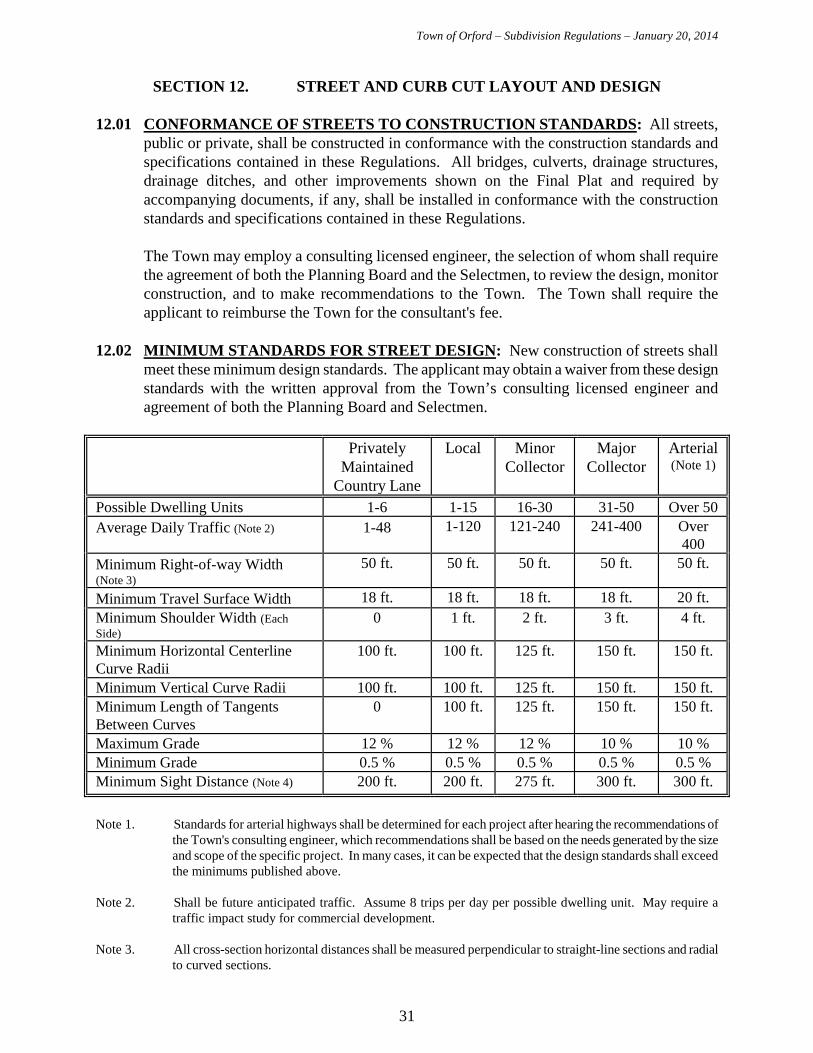
12.02 MINIMUM STANDARDS FOR STREET DESIGN: New construction of streets shall
meet these minimum design standards. The applicant may obtain a waiver from these design standards with the written approval from the Town’s consulting licensed engineer and agreement of both the Planning Board and Selectmen.
Privately
Maintained Country Lane
Local Minor Collector
Major Collector
Arterial (Note 1)
Possible Dwelling Units 1-6 1-15 16-30 31-50 Over 50 Average Daily Traffic (Note 2)
1-48 1-120 121-240 241-400 Over
400 Minimum Right-of-way Width (Note 3)
50 ft. 50 ft. 50 ft. 50 ft. 50 ft. Minimum Travel Surface Width 18 ft. 18 ft. 18 ft. 18 ft. 20 ft. Minimum Shoulder Width (Each Side)
0 1 ft. 2 ft. 3 ft. 4 ft.
Minimum Horizontal Centerline Curve Radii
100 ft. 100 ft. 125 ft. 150 ft. 150 ft.
Minimum Vertical Curve Radii 100 ft. 100 ft. 125 ft. 150 ft. 150 ft. Minimum Length of Tangents Between Curves
0 100 ft. 125 ft. 150 ft. 150 ft.
Maximum Grade 12 % 12 % 12 % 10 % 10 % Minimum Grade 0.5 % 0.5 % 0.5 % 0.5 % 0.5 % Minimum Sight Distance (Note 4) 200 ft. 200 ft. 275 ft. 300 ft. 300 ft.
Note 1. Standards for arterial highways shall be determined for each project after hearing the recommendations of
the Town's consulting engineer, which recommendations shall be based on the needs generated by the size and scope of the specific project. In many cases, it can be expected that the design standards shall exceed the minimums published above.
Note 2. Shall be future anticipated traffic. Assume 8 trips per day per possible dwelling unit. May require a
traffic impact study for commercial development. Note 3. All cross-section horizontal distances shall be measured perpendicular to straight-line sections and radial
to curved sections.
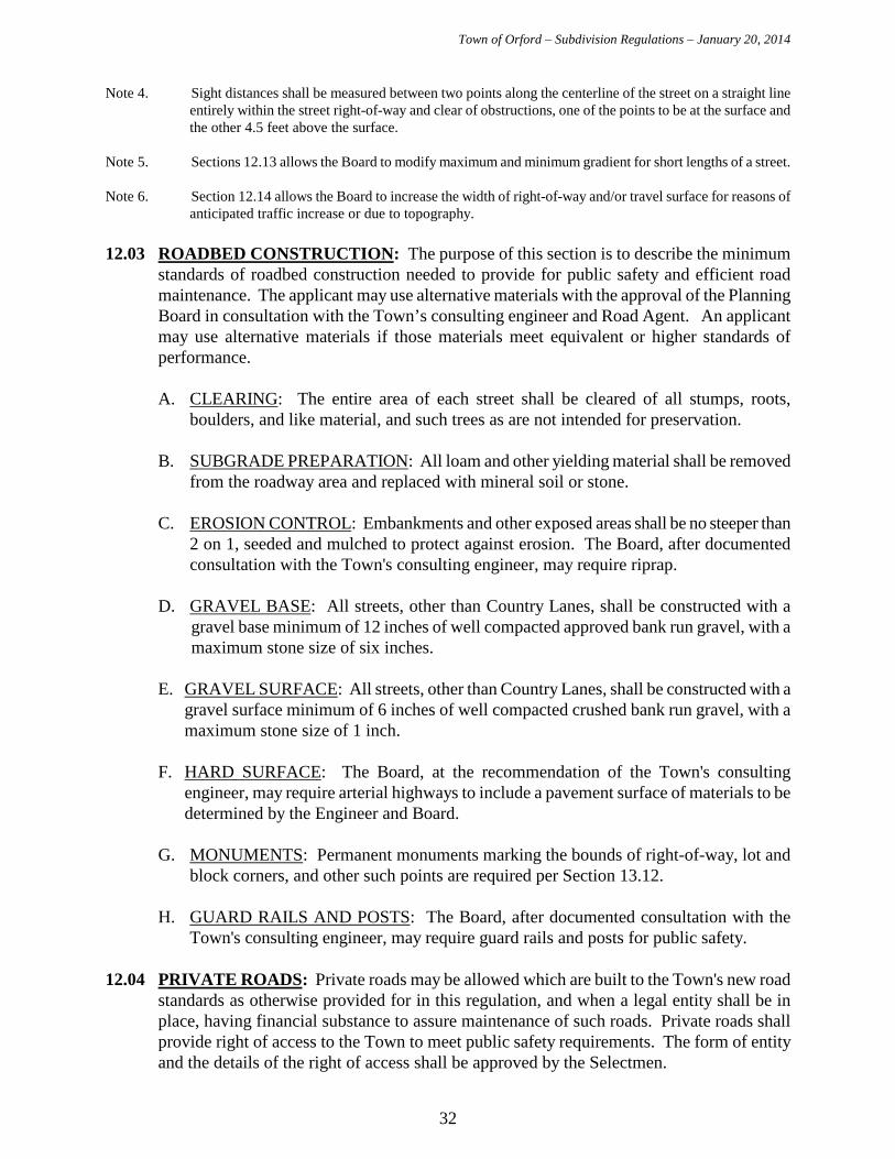
Town of Orford – Subdivision Regulations – January 20, 2014
32
Note 4. Sight distances shall be measured between two points along the centerline of the street on a straight line entirely within the street right-of-way and clear of obstructions, one of the points to be at the surface and the other 4.5 feet above the surface.
Note 5. Sections 12.13 allows the Board to modify maximum and minimum gradient for short lengths of a street. Note 6. Section 12.14 allows the Board to increase the width of right-of-way and/or travel surface for reasons of
anticipated traffic increase or due to topography. 12.03 ROADBED CONSTRUCTION: The purpose of this section is to describe the minimum
standards of roadbed construction needed to provide for public safety and efficient road maintenance. The applicant may use alternative materials with the approval of the Planning Board in consultation with the Town’s consulting engineer and Road Agent. An applicant may use alternative materials if those materials meet equivalent or higher standards of performance.
A. CLEARING: The entire area of each street shall be cleared of all stumps, roots,
boulders, and like material, and such trees as are not intended for preservation.
B. SUBGRADE PREPARATION: All loam and other yielding material shall be removed from the roadway area and replaced with mineral soil or stone.
C. EROSION CONTROL: Embankments and other exposed areas shall be no steeper than
2 on 1, seeded and mulched to protect against erosion. The Board, after documented consultation with the Town's consulting engineer, may require riprap.
D. GRAVEL BASE: All streets, other than Country Lanes, shall be constructed with a
gravel base minimum of 12 inches of well compacted approved bank run gravel, with a maximum stone size of six inches.
E. GRAVEL SURFACE: All streets, other than Country Lanes, shall be constructed with a
gravel surface minimum of 6 inches of well compacted crushed bank run gravel, with a maximum stone size of 1 inch.
F. HARD SURFACE: The Board, at the recommendation of the Town's consulting engineer, may require arterial highways to include a pavement surface of materials to be determined by the Engineer and Board.
G. MONUMENTS: Permanent monuments marking the bounds of right-of-way, lot and block corners, and other such points are required per Section 13.12.
H. GUARD RAILS AND POSTS: The Board, after documented consultation with the
Town's consulting engineer, may require guard rails and posts for public safety. 12.04 PRIVATE ROADS: Private roads may be allowed which are built to the Town's new road
standards as otherwise provided for in this regulation, and when a legal entity shall be in place, having financial substance to assure maintenance of such roads. Private roads shall provide right of access to the Town to meet public safety requirements. The form of entity and the details of the right of access shall be approved by the Selectmen.
Town of Orford – Subdivision Regulations – January 20, 2014
33
12.05 COUNTRY LANE: A Country Lane is a privately maintained road, which serves no more
than a combined total of six present or possible future dwellings. As a condition to the Town agreeing to the lower minimum road standards named in Section 12.02 and 12.03, each owner of properties served by the Country Lane must enter into an agreement with the Town, which agreement(s) shall be recorded with the Grafton County Registry of Deeds, that the Country Lane will be improved by the private owners to meet the then existing new road standards if, at some future time, the owner(s) shall petition the Town to layout the road.
12.06 CONNECTION WITH EXISTING SUBDIVISIONS: When improvements are to be
installed between the proposed street pattern and any connection street in an existing subdivision, they shall be indicated on the Final Plat.
12.07 HARMONY WITH TOPOGRAPHY AND NATURAL FEATURES: New roads shall
be laid out to blend with existing contours and other natural features. In the building of the road, the edges of the cleared roadway shall be left in a condition which is scenic and which emphasizes any special trees, stonewalls, or other natural features.
12.08 INTERSECTIONS AND GRADES: Streets shall intersect so that within 75 feet of the
intersection the street lines are at right angles, and in no case shall they be less than 75 degrees. The grade within 100 feet of an intersection shall not exceed five percent. No structure or planting shall impair corner visibility.
12.09 PERMANENT DEAD-END STREET: A permanent dead-end street shall terminate in a
suitable (See Section 12.18 for the "Design of Turnarounds" for what is suitable) turnaround. The turnaround shall be designed to provide for adequate drainage. Unless there is the expectation of extending the street through to the adjoining property, a dead-end street shall be brought to the property boundary line but shall be placed so that the lots are contiguous with the property line of the subdivision. The maximum length of a permanent dead-end street shall be determined by the Board.
12.10 TEMPORARY DEAD-END STREETS: In the case of temporary dead-end streets, where future extension to another outlet is approved by the Board, the full width of the right-of-way to the subdivision property line shall be reserved as a street right-of-way, and shall be shown on the Final Plat. For a dead-end street of a temporary nature, a turnaround shall be provided, and provision shall be made for future extension of the street through to adjacent property and for reversion of the access right-of-way to the adjoining properties.
12.11 MARKING OF PROPOSED STREETS: At the earliest practical stage during the
application, the applicant shall place on the ground clearly observable survey stakes or ribbons marking the centerline of all proposed streets.
12.12 ALTERATION OF GRADIENT: The Board may modify the maximum and minimum gradient for short lengths of street where, in the judgment of the Board, existing topographic conditions or the preservation of natural features indicate that such modification will result in the best subdivision of land.
12.13 ALTERATION OF RIGHT-OF-WAY TO TRAVEL SURFACE: The Board may
require greater width of right-of-way and/or travel surface where, in the judgment of the
Town of Orford – Subdivision Regulations – January 20, 2014
34
Board, the demands of present or future traffic make it desirable, or where topographic conditions create a need for greater width for grading.
12.14 FOOTPATHS: Where necessary in the judgment of the Board, rights-of-way for footpaths
may be required between parts of the subdivision or between a subdivision and public property. When such need has been created by subdivision, the Board may require the applicant to provide footpaths outside the subdivision.
12.15 STREET LIGHTING: The Board, after documented consultation with the Town's
consulting engineer, may require the installation of street lighting for public safety. 12.16 NAMING OF STREETS: No street shall have a name, which will duplicate or closely
duplicate the name of an existing street. The continuation of an existing street shall have the same name.
12.17 DESIGN OF TURNAROUNDS: Dead-end streets shall be equipped with a turnaround at
the closed end whose radius from the center to the outer edge of the right-of-way is at least sixty (60) feet. Alternative designs may be approved by the Planning Board and Road Agent.
12.18 CURB CUTS: Curb cuts intersecting Town highways or private roads require approval of
the Planning Board pursuant to the Orford Curb Cut Regulations. The curb cut intersection with the street providing frontage shall be constructed within one year of the approval, per Curb Cut Regulations, to such a length as to include any design features specified in the curb cut permit. Applications for curb cut permits are made to the Planning Board. Curb cuts intersecting State highways require a State driveway permit.
Town of Orford – Subdivision Regulations – January 20, 2014
35
SECTION 13. CONSTRUCTION OF SUBDIVISION 13.01 ADMINISTRATIVE OFFICER: During construction of an approved subdivision, the
administrative officer for the Regulations shall be the Selectmen or their designated agent. 13.02 TIME FOR COMPLETION OF CONSTRUCTION: The applicant shall construct the
subdivision and shall comply with all requirements set forth in the Notice of Action within three years from the date of issue of the Notice of Action. Upon written request of the applicant, when the Board finds that conditions beyond the control of the applicant prevent compliance within the three year period, the Board may grant an additional period of time for compliance with the Notice up to two years.
13.03 RELEASE OF SECURITY: The security required in section 5.11 shall be released when
the Selectmen are satisfied that the applicant has complied with all requirements as set forth in the Notice of Action and shown on the approved plat. The decision to release the security shall be based upon an assessment of the plans, the engineers' preparatory work for construction, engineering inspection during construction, and the final plans of completed work. The Selectmen shall notify the Board that all conditions of the security have been performed and shall have the authority to release the security, unless, after notification, the Board directs otherwise. A portion of the security may be held an additional year to cover maintenance of improvements.
The security may be reduced during the course of construction by the Selectmen in such amounts as the Selectmen deem to be in the best interest of the Town, but on the condition that the remaining security shall be sufficient to complete all remaining construction.
13.04 ENFORCEMENT OF SECURITY: If the applicant has not totally complied within three years of the date of issue of the Notice of Action, the Town shall enforce its rights under the security. In the event that the Town is required to enforce the security, it shall be entitled to have reasonable attorney's fees paid by the applicant and awarded by the court.
13.05 MODIFICATION OF DESIGN AND IMPROVEMENTS: If, at any time before or
during the construction of the subdivision, the Board determines that unforeseen conditions make it necessary or desirable to modify the location or design of any of the required improvements or installations, the Board may authorize such modifications without public hearing which shall be set forth in writing and signed by the Chairman of the Board.
13.06 INSPECTION OF CONSTRUCTION: Prior to the signing and recording of the plat, the
applicant shall pay to the Town an amount of money estimated by the Selectmen to compensate fully the Town for all inspection and testing charges deemed necessary. The applicant shall notify the Selectmen, in writing, of the time when construction is proposed to commence so the Selectmen may cause inspection to be made to insure that all Town specifications and requirements shall be met.
13.07 CERTIFICATION OF COMPLIANCE: The applicant shall notify the Selectmen, in
writing, when all requirements of the Final Plat have been met. The applicant's engineer shall certify compliance with the Notice of Action and approved final plat, including total recertification to the extent necessary of any original installation, the guarantee, and damage deficiencies.
Town of Orford – Subdivision Regulations – January 20, 2014
36
13.08 CORRECTION OF DEFICIENCIES: If the Selectmen determine that any of the required
improvements have not been completed in accordance with the plans and specifications as filed by the applicant and as required by the Town, the Selectmen shall notify the applicant, in writing, of any such deficiencies. The applicant shall rectify all deficiencies at the expense of the applicant. If the applicant does not substantially rectify all deficiencies within a reasonable time, as determined by the Town, the Town shall take all necessary action to protect and preserve the Town's rights and interests, including suspension or revocation of Final Plat approval. In the event of legal action, the Town shall be entitled to have reasonable attorney's fees paid by the applicant and awarded by the court.
13.09 GUARANTEE OF INSTALLATION OF IMPROVEMENTS: For a period of two years
after completion of all improvements, or one year after the correction of all deficiencies as described above, whichever occurs last, if the Selectmen determine that the improvements have failed for any reason or do not meet the specifications as filed by the applicant and as required by the Town, the Selectmen shall notify the applicant, in writing, of such failure, and the applicant shall rectify all failures at the expense of the applicant. If the applicant does not substantially rectify all deficiencies within a reasonable time as determined by the Town, Selectmen shall take all necessary action to protect and preserve the Town's rights and interests. In the event of legal action, the Town shall be entitled to have reasonable attorney's fees paid by the applicant and awarded by the court.
13.10 DAMAGE TO ADJACENT PUBLIC AND PRIVATE PROPERTY, DRAINAGE
FACILITIES, WATERWAYS, STREAMS, AND BROOKS: If, at any time before all public improvements are finally approved by the Town and before the security is totally released, should any condition within the approved subdivision cause damage to adjacent public or private property, drainage facilities and waterways, streams and brooks, including but not limited to soil erosion and damage to standing vegetation, the Selectmen shall notify the applicant, in writing, of such damage and the applicant shall correct all damage at the applicant's own expense. If the applicant does not substantially correct all damage within a reasonable period of time as set forth in the notice by the Town, the Town shall take all action necessary to protect and preserve its rights and interests, including injunctive relief. The Town shall be entitled to have reasonable attorney's fees paid by the applicant and awarded by the court.
13.11 EROSION CONTROL AFTER CONSTRUCTION: For a period of two years after
completion of all improvements or as determined by the Planning Board, the applicant shall be responsible for the control of soil erosion and any resulting sedimentation.
13.12 MONUMENTS: Permanent survey monuments shall be set in the boundary of rights-of-
way at intersecting streets, point of curvature, and point of tangency of curves; the point of intersection of short curves may be used instead, where such is practical, at the discretion of the Selectmen. Monuments shall be placed on one side of the street only and at only one corner of the intersecting streets. Adjacent monumented points shall be in sight of one another.
Monuments shall be referenced to a public street intersection, USGS benchmark or other recognized existing monument.

Town of Orford – Subdivision Regulations – January 20, 2014
37
Monuments shall be of stone, concrete, or other material acceptable to the Selectmen, and not less than 4 inches in diameter or square, and not less than 42 inches long. Concrete monuments shall be reinforced with steel rods. A plug brass plate or pin shall serve as the point of reference, and a magnetic rod or other suitable metal device shall be placed adjacent to the monument to allow for recovery.
Iron pipes shall not be considered permanent monuments for the purpose of these Regulations.
13.13 CONVEYANCE OF EASEMENTS AND RIGHTS-OF-WAY: Upon completion of the
construction of the subdivision, the applicant shall convey all easements and rights-of-way as may be required under the Notice of Action, by deeds in a form and manner satisfactory to the Town Counsel.
Town of Orford – Subdivision Regulations – January 20, 2014
38
APPENDIX FOR INFORMATIONAL PURPOSES - PUBLIC
ROAD SYSTEM Functional Classification: The New Hampshire Department of Transportation classifies all road mileage in the state according to the following system: Class I, Primary State Highways, consist of all existing or proposed highways on the primary state highway system, excepting all portions of such highways within the compact sections of towns and cities of 7,500 inhabitants and over. The state assumes full control and pays costs of construction, maintenance and reconstruction of its sections; the portions in compact areas are controlled by the towns and cities under Class IV highways. Class II, Secondary State Highways, consist of all existing or proposed highways on the secondary state highway system, excepting portions of such highways within the compact sections of towns and cities of 7,500 inhabitants and over, which are classified as Class IV highways. All sections improved to the satisfaction of the highway commissioner are maintained and reconstructed by the State. All unimproved sections, where no state and local funds have been expended, must be maintained by the Town or City in which they are located until improved to the satisfaction of the commissioner. All bridges improved to State standards with State Aid Bridge funds are maintained by the State. All other bridges shall be maintained by the City or Town until such improvements are made. Class III, Recreational Roads, consist of all such roads leading to, and within, state reservations designated by the Legislature. The State Highway Department assumes full control of reconstruction and maintenance of such roads. Class IV, Town and City Streets, consist of all highways within the compact sections of towns and cities of 7,500 inhabitants and over. Extensions of Class I and Class II highways through these areas are included in this classification. Class V, Rural Highways, consist of all other traveled highways which the town or city has the duty to maintain regularly. Class VI, Unmaintained Highways, consist of all other existing public ways including highways discontinued as open highways, highways closed subject to gates and bars, and highways not maintained in suitable condition for travel for five years or more. Construction on Class VI Highways: No building may be constructed on a lot fronting on a Class VI highway without a permit obtained from the Board of Selectmen, as provided in RSA 674:41. The town will accept no responsibility for the Class VI highway nor liability for any damages resulting from the use there of. Before approval, notice of the limits of town responsibility and liability, as per RSA 674:41, shall be recorded in the Registry of Deeds.
Town of Orford – Subdivision Regulations – January 20, 2014
39
These regulations were amended January 20, 2014 by the Orford Planning Board. Planning Board Approval:
_____________________ Ann Green, Chair _____________________ Andrew Schwaegler, Vice-Chair _____________________ Jim McGoff, Secretary
_____________________ Tom Steketee, Select Board Representative _____________________ Harry Osmer, Member _____________________ Lawrence Hibbard, Member _____________________ Allen Martin, Member
Adopted May 20, 1971 Amended May 26, 1976
Amended February 20, 1979 Amended December 30, 1986
Amended July 18, 1988 Amended November 21, 1988 Amended February 25, 1991
Amended June 16, 1997 Amended November 15, 1999 Amended October 15, 2001
Amended November 18, 2002 Amended April 19, 2004 Amended June 21, 2010
Amended August 24, 2010 Amended January 20, 2014