Embed Size (px)
Citation preview
CITY OF PORTSMOUTH, NEW HAMPSHIRE
SUBDIVISION RULES AND REGULATIONS
Adopted by Portsmouth Planning Board: March 14, 1985 Last Revision: September 15, 2016

Subdivision Rules and Regulations (rev. September 2016) i
SUBDIVISION RULES AND REGULATIONS
TABLE OF CONTENTS
PURPOSE ...................................................................................................................................... 1
SECTION I - AUTHORITY ........................................................................................................ 2
SECTION II - DEFINITIONS ..................................................................................................... 2
SECTION III - PROCEDURE FOR SUBDIVISION AND LOT LINE CHANGE ............... 4 A. Preapplication Review ........................................................................................................ 4 B. Review by Technical Advisory Committee ........................................................................ 5 C. Applicant's Responsibilities ................................................................................................ 6 D. Planning Board Procedures ................................................................................................. 7 E. Approval Expiration and Extension .................................................................................... 8 F. Certification of Final Approval ........................................................................................... 9 G. Post-Approval Procedures .................................................................................................. 9
SECTION IV - REQUIREMENTS FOR PRELIMINARY PLAT ........................................ 10
SECTION V - REQUIREMENTS FOR FINAL PLAT .......................................................... 12
SECTION VI - GENERAL REQUIREMENTS ...................................................................... 14 1. Basic Requirements .......................................................................................................... 14 2. Lots ................................................................................................................................... 14 3. Streets ................................................................................................................................ 15 4. Curbing ............................................................................................................................. 18 5. Driveways ......................................................................................................................... 18 6. Drainage Improvements .................................................................................................... 18 7. Municipal Water Service .................................................................................................. 18 8. Municipal Sewer Service .................................................................................................. 19 9. Installation of Utilities ...................................................................................................... 19 10. On-Site Water Supply ....................................................................................................... 20 11. On-Site Sewage Disposal Systems ................................................................................... 20 12. Open Space ....................................................................................................................... 20 13. Flood Hazard Areas .......................................................................................................... 21 14. Erosion and Sedimentation Control .................................................................................. 22 15. Easements ......................................................................................................................... 23 16. Monuments ....................................................................................................................... 24 17. Benchmarks....................................................................................................................... 24 18. House Numbers ................................................................................................................. 24
Subdivision Rules and Regulations (rev. September 2016) ii
SECTION VII - DESIGN STANDARDS ................................................................................. 25 1. Streets ................................................................................................................................ 25 2. Storm Water Sewers and Other Drainage Appurtenances ................................................ 27 3. Sanitary Sewers ................................................................................................................. 28 4. Water Mains and Fire Hydrants ........................................................................................ 29
SECTION VIII - FINAL PLAN REQUIREMENTS .............................................................. 31 A. Submission Requirements ................................................................................................. 31 B. Specifications .................................................................................................................... 31
SECTION IX - DEVELOPMENT PREREQUISITE TO FINAL APPROVAL .................. 32 1. Improvements and Installation Bonds .............................................................................. 32 2. Maintenance Bonds ........................................................................................................... 32
SECTION X – WAIVER OF REGULATIONS ....................................................................... 32
SECTION XI – AMENDMENTS .............................................................................................. 33
Subdivision Rules and Regulations (rev. September 2016) 1
PURPOSE Consistent with the purpose of the State enabling legislation (RSA 36-21), these regulations are intended to insure the orderly development of the City of Portsmouth by providing that subdivisions are served with adequate utilities and safe, convenient access and with a desirable and attractive living environment. Furthermore, it is the intent of the Planning Board to promote the utilization of sound development standards which are directed toward providing realistic and feasible costs both for the initial project development as well as for continued maintenance of all of the project's public systems by the City. Among the objectives of the subdivision regulations are:
1. A proper distribution of the population which is compatible with adjacent uses while providing for the harmonious development of the municipality and its environs.
2. The avoidance of overcrowding of population, blighted areas and congestion of vehicular
traffic. 3. The avoidance of development which impedes the function of the natural drainage system
and flood areas. 4. The proper location and width of streets, open spaces, recreational areas and public lands. 5. The use of established engineering standards for the installation of improvements in the
provision of water, sewer, storm drainage and other utility services, and also the proper grading and construction practices of streets.
6. The provision of adequate space for traffic circulation and parking; for access of
emergency apparatus; and for control of the number, spacing, type and design of access points to existing and future streets.
Subdivision Rules and Regulations (rev. September 2016) 2
SECTION I - AUTHORITY The Portsmouth Planning Board prescribes the following rules and regulations to control the subdivision of land pursuant RSA 674:35 et seq. – Regulation of Subdivision of Land and the City of Portsmouth Ordinances, Chapter 11, Article IV – Subdivision of Land.
SECTION II - DEFINITIONS Except where specifically defined herein, all words used in the Rules and Regulations shall carry their customary meaning. Abutter: Any person who owns land within two hundred (200) of the boundaries of the land under consideration. Alley: A public or private right-of-way primarily designed to serve as secondary access to the side or rear of those properties otherwise abutting on a street. Applicant: The owner of record of the land for which subdivision is proposed. The holder of an option or agreement to purchase the subject property shall be co-listed as an applicant. Board: The Planning Board of the City of Portsmouth, New Hampshire. Building: Any structure whether temporary, semi-permanent, or permanent, designed or intended for the support, enclosure, shelter, or protection of persons, animals, or property. Cul-de-sac: A local street with only one outlet and having an appropriate terminal for the safe and convenient reversal of traffic movement. Development: Any change in a lot by the property owner or agent presumably to increase the value of the lot. Driveway: A private road intended to provide vehicular access from a public way onto a single lot. Easement: Authorization by a property owner for any type of use by another for a specified purpose of any designated part of his property. Flood Hazard Zone: That portion of land which has one percent (1%) chance of flooding in any given year, as designated on Flood insurance Rate Maps issued by the Federal Insurance Administration, if available, or on Flood Hazard Boundary Maps issued by the Federal Insurance Administration otherwise. Frontage: A continuous portion of a boundary of a lot which abuts a street, ordinarily regarded as the front of the lot. When a lot is bounded by more than one street, any one of them , but only one, may be designed as the frontage street by the owner, provided that the street meets the frontage requirement and the principal permitted building on the lot is numbered on such street.
Subdivision Rules and Regulations (rev. September 2016) 3
Lot: A tract, plot or portion of a subdivision or other parcel of land in one ownership with definite boundaries ascertainable by recorded deed or plan which is available for use as a building site or for any other definite purpose. Plat: The map, drawing or chart on which the subdivider's plan of subdivision is presented to the Planning Board for approval. Resubdivision: A change in an approved or recorded subdivision plat if such change affects any street layout on such plat or area reserved thereon for public use, or any lot line; also a change in any map or plan legally recorded prior to the adoption of any regulations controlling subdivisions. Right-of-way: A part of a lot provided by the property owner for use by a second party. Rights-of-way involving maintenance by a public agency shall be dedicated to public use on a subdivision plat. Screening: Either (A) a strip of at least ten (10) feet wide, densely planted (or having equivalent natural growth) shrubs or trees at least four (4) feet high at the time of planting of an evergreen type that will grow to a year round dense screen at least six (6) feet high within three (3) years; or (B) an opaque wall or barrier or uniformly painted fence at least six (6) feet height. Screening of either type shall be maintained in good condition at all times. Street: A right-of-way which has been dedicated or intended for public travel or a private way offering the principal means of access to more than one lot. Also included are terms such as avenue, boulevard, road, lane, alley, highway, viaduct, freeway, court, way, and drive. Subdivision: “Subdivision” means the division of the lot, tract, or parcel of land into two or more lots, plats, sites, or other divisions of land for the purpose, whether immediate or future, of sale, rent, lease, condominium conveyance or building development. It includes resubdivision and, when appropriate to the context, relates to the process of subdividing or to the land or territory subdivided. The division of a parcel of land held in common and subsequently divided into parts among the several owners shall be deemed a subdivision under this title. (Revised 3/14/85) Wetland: An area with soils having poor drainage where the water table is at or near the ground surface for at least seven months of the year. Vegetation present which are characteristic of wet areas shall serve as above ground indications of wetlands.
Subdivision Rules and Regulations (rev. September 2016) 4
SECTION III - PROCEDURE FOR SUBDIVISION AND LOT LINE CHANGE A. Preapplication Review
1. Preapplication Review – General
a. An applicant may request to meet with the Planning Board for preliminary nonbinding discussions of a proposal as authorized by RSA 676:4, II, and as further provided herein. An applicant may request to meet with the Board for either Preliminary Conceptual Consultation or Design Review, or both. The preliminary conceptual consultation phase is mandatory for certain applications as stated in Section III.A.2 below.
b. Discussions in the Preliminary Conceptual Consultation and Design Review
Phases shall not bind either the applicant or the Board. Statements made by Planning Board members during either phase shall not be a basis for disqualifying said members or invalidating any action subsequently taken by the Board.
c. Preliminary review shall be separate and apart from formal consideration of an
application for subdivision approval, and the time limits for acting on a proposal shall not apply until a formal application has been submitted and has been determined by the Planning Board to be complete.
2. Preliminary Conceptual Consultation Phase [see RSA 676:4,II(a)]
a. The applicant may request a meeting with the Planning Board to discuss a proposal in conceptual form. The preliminary conceptual consultation phase is mandatory for any application that includes the subdivision of more than 5 acres of land or the creation of more than 5 lots, and shall precede referral and review to the Technical Advisory Committee.
b. A request for preliminary conceptual consultation shall be submitted to the
Planning Department at least 21 days prior to the date of a scheduled meeting of the Board, and shall be accompanied by 12 copies of any plans, sketches and other documents or exhibits to be discussed with the Board, along with digital copies of said documents and exhibits in Portable Document Format (PDF).
c. Preliminary conceptual consultation may occur only at formal meetings of the
Planning Board. However, such discussions shall not be the subject of a public hearing, and formal notice of abutters and the public shall not be required.
d. Preliminary conceptual consultation shall be directed at review of the basic
concept of the proposal and suggestions that might be of assistance in resolving problems with meeting requirements during final consideration. The Board and the applicant may discuss proposals in conceptual form only and in general terms
Subdivision Rules and Regulations (rev. September 2016) 5
such as the desirability of the proposed development type, scale, intensity and layout under the Master Plan.
3. Design Review Phase [see RSA 676:4,II(b)]
a. The applicant may request to meet with the Board for nonbinding discussions of a potential application that involve more specific design and engineering details than in the preliminary conceptual consultation phase.
b. A request for design review shall be submitted to the Planning Department at least
21 days prior to the date of a scheduled meeting of the Board, and shall be accompanied by 12 copies of all plans and exhibits, along with digital copies of said documents and exhibits in Portable Document Format (PDF).
c. The request for design review shall include enough of the information listed in
Section IV – Requirements for Preliminary Plat so that the Board is able to review the project. Detailed engineering of infrastructure and utilities are not required at the design review phase, but the information listed in Section IV should be displayed in sufficient detail to enable the Board to understand the proposed project and identify potential issues and concerns.
d. At a regular meeting of the Planning Board, the Board shall determine if the
request for design review includes sufficient information to allow the Board to understand the project and identify potential issues and concerns, and shall vote on whether to accept the request for design review and to schedule a public hearing. If the Board determines that the request does not describe the proposed project in sufficient detail, it shall notify the applicant of the specific deficiencies that need to be addressed.
e. Design review discussions shall take place in a public hearing at a regularly
scheduled meeting of the Planning Board, after notice to abutters, holders of conservation, preservation, or agricultural preservation restrictions, and the general public as required by State statute.
f. At any public meeting of the Planning Board, the Board may determine that the
design review process of an application has ended and shall inform the applicant in writing within 10 days of such determination.
B. Review by Technical Advisory Committee
1. The Site Plan Review Technical Advisory Committee (TAC) established in Section 2.2.1 of the Site Plan Review Regulations shall review any application for subdivision approval prior to Planning Board review if it contains any of the following:
a. Creation of a new lot; b. Construction of a new public or private street;
Subdivision Rules and Regulations (rev. September 2016) 6
c. Widening or realignment of an existing public or private street; d. Construction of public or private water, sewer or stormwater facilities serving
more than one lot; e. Establishment of an easement over one lot for water, sewer or stormwater
facilities to serve a different lot; or f. Provision of a common driveway or access easement;
2. In addition to the applications that are required to be reviewed by TAC as provided
above, the Planning Board may refer any application for subdivision approval to TAC where it determines that such review is advisable.
3. The procedure for TAC review of subdivision applications shall be the same as for site
plan review. C. Applicant's Responsibilities
1. The applicant is invited to discuss the plans for subdivision with the Planning Department on an informal basis prior to formal application.
2. When review by TAC is required under Section III.B.1, the applicant shall submit a
completed application on a form entitled “Subdivision Application” along with 12 copies of the preliminary or final plat and supporting documents and studies. The application shall be submitted by the deadline established by the Planning Department for submission of applications for site plan approval, and in any case not later than 31 days prior to the meeting at which the application will be accepted. After review of the application by the TAC, the applicant shall submit 12 copies of the application to the Planning Board.
3. When review by TAC is not required under Section III.B.1, the applicant shall submit to
the Planning Board an application in writing on a form entitled “Subdivision Applica-tion”, along with 12 copies of the preliminary or final plat and supporting documents and studies, not later than 21 calendar days prior to the meeting at which the application will be accepted.
4. All application documents, plans, supporting documentation and other materials shall
also be provided in digital Portable Document Format (PDF) on compact disc, DVD or flash drive. Digital files shall be complete and exact copies of the corresponding paper submittals (e.g., plans shall be at the same scale and sheet size as the paper copies). Applicants may submit additional digital files to assist in presentations at public hearings, but such additional digital files shall not be considered part of the application unless corresponding paper documents are also provided.
5. At the time of submission of the application and preliminary or final plans, the applicant
shall pay a fee as set by City Ordinance. All postage costs for abutter notices and proportionate share of legal advertising shall be
paid prior to the Public Hearing.
Subdivision Rules and Regulations (rev. September 2016) 7
6. Where subsequent Public Hearings for a project are required for Preliminary Subdivision
Approval and/or Final Subdivision Approval, the postage costs for abutter notices and a proportionate share of legal advertising shall be paid prior to the Public Hearing.
7. If an application is withdrawn prior to a Public Hearing, the applicant will be allowed to
resubmit the application before the next regularly scheduled Board meeting in conformance with Section III.B.2. and be held responsible for the costs of postage, abutter notices, and a proportionate share of legal advertising only. Where the application is not resubmitted in accordance with Section III.B.2. it will then be considered as a new application and all costs shall be as if the application is being submitted for the first time.
8. The applicant or an authorized representative should appear at the hearing held by the
Board on the proposed subdivision to explain the plan and to answer questions which may be asked by Board members.
9. Preliminary Approval shall expire unless a mylar and twelve (12) copies of the final plat
(see Section V for final plat requirements) are submitted to the Planning Board within one (1) year from the date that preliminary approval is granted. The Board may, for good cause shown, extend such period by as much as one (1) year if requested and acted upon, prior to the expiration date. No other extensions may be requested.
10. The applicant shall also submit payment for the Registrar of Deeds to cover the current
cost of filing of plats. The application for “Approval of Subdivision of Land” shall itemize such charges.
D. Planning Board Procedures
1. Upon receipt of a formal application and preliminary plans, the Board shall place on its agenda for consideration any plat submitted to it within thirty (30) days. No plat shall be approved or disapproved by the Board without affording a public hearing thereon. Such hearing shall be duly advertised and the applicant and abutters shall be notified of the time and place of such hearing not less than ten (10) days prior to the hearing.
At the Board meeting, the Board shall act to deny any application which is not in
compliance with Section IV or V as appropriate. 2. Following a hearing on the subdivision plan, the Board shall approve, conditionally
approve, deny or table the proposed subdivision plans. Approval of a preliminary plat shall become null and void after one (1) year unless a final plat is submitted to the Board or the Board grants an extension of time.
3. The Board shall notify the applicant, in writing, within twenty (20) working days, as to its
decision. If the Board denies the preliminary plans, the Planning Board Chairman shall provide to the applicant, in writing, the reasons for the denial.
Subdivision Rules and Regulations (rev. September 2016) 8
4. The Board shall act to approve or disapprove a preliminary plat within ninety (90) days after acceptance of the application, unless the applicant waives this requirement or the City Council, upon request by the Board, grants an extension not to exceed an additional ninety (90) days. Upon failure of the Board to approve or disapprove the application, the applicant may obtain from the City Council an order directing the Board to act within fifteen (15) days. Failure of the Board to act upon such order of the City Council shall constitute grounds for appeal to the Superior Court, upon petition of the applicant, to issue an order approving the application if the Court determines that the proposal complies with existing subdivision regulations, zoning, and other ordinances. If the Court determines that failure to act within the time specified was the fault of the Board and was not justified, the Court may order the Board to pay the applicant's reasonable costs, including attorney's fees, incurred in securing such order.
5. Upon submission of a final plat, the Board shall approve or disapprove the final plat. 6. Once the final plat has been approved by the Board and the Chair’s signature is affixed
thereon, it shall be retained by the Planning Department and filed by that Department with the Rockingham County Registry of Deeds within twenty (20) working days, provided that all appropriate fees have been paid by the applicant. The applicant shall have the required site plans pre-approved by the Registry of Deeds prior to submitting mylars to the Planning Department for signature and recording.
7. The Planning Board Chair and the Vice-Chair are authorized to sign at their discretion
plats which show a lot line change provided:
a. there is no increase in the number of lots; b. the resultant lot dimensions and area are in conformance with the Zoning
Ordinance and these Subdivision Rules and Regulations; and c. direct abutters have been given notice of the lot line change and have not
requested to be heard.
Nothing shall compel the Chair or Vice-Chair to sign a plat for a Lot Line Change when in their opinion the public interest would be better served through a review by the full Board.
E. Approval Expiration and Extension
1. All stipulations of subdivision approval, including recording of the plat as required by the Planning Department, shall be completed within 6 months of the date of approval by the Planning Board.
2. The Planning Director may grant an extension of up to 6 months if he determines that the
applicant has been unable to complete a stipulation due to circumstances beyond the applicant’s control.
Subdivision Rules and Regulations (rev. September 2016) 9
3. The applicant may apply to the Planning Board for an extension of the time for
completion, which shall not exceed 18 months from the original date of Planning Board approval of the subdivision.
4. If all stipulations have not been completed or the plan has not been recorded within the
time required under paragraph 1 above, or within an extended time under paragraph 2 or 3 above (if applicable), the Planning Board’s approval shall be deemed null and void.
F. Certification of Final Approval
1. Where the Planning Board has granted subdivision approval subject to conditions, such
approval shall become final upon certification by the Planning Director that the applicant has satisfactorily complied with the conditions imposed.
2. Within 14 days of a final subdivision approval, the Planning Director shall forward to the
Assessor a digital copy of the approved plan and a copy of the certification of final approval..
G. Post-Approval Procedures
1. Administrative Approval of Minor Plan Amendments
After approval of the final plat by the Planning Board, the owner may request, in writing, approval of minor amendments. The Planning Director may approve the amendment in writing or may require review by the TAC or the Planning Board. The amended plat shall filed in the Registry of Deeds. Such amended approval shall not extend the time period for completing stipulations of the original approval.
2. Minor Field Modifications to Required Improvements
If at any time before or during the construction of the required improvements the applicant demonstrates to the satisfaction of the Public Works Department that unforeseen conditions make it necessary or preferable to modify the design of the required improvement, the Public Works Department may authorize modifications provided that the modifications do not amount to a waiver or substantial alteration of the function of any improvements required by the Board.
Subdivision Rules and Regulations (rev. September 2016) 10
SECTION IV - REQUIREMENTS FOR PRELIMINARY PLAT Whenever the preliminary plat includes more than two proposed lots, new streets, utility mains, pumping stations, or any other major improvement, the plat must be prepared and certified by an engineer registered in New Hampshire. The following items shall be included on the preliminary plat:
1. Name and address of record owner, any option holders, descriptive name of subdivision,
and name of person who prepared the plat. 2. Names and addresses of all adjoining property owners. 3. North point, date, and bar scale. 4. Zoning classification(s). 5. The scale of the layout, not to be smaller than one hundred (100) feet to an inch and
where possible, shall be compatible with the scale of the City's tax assessor maps. The plat shall also include a location map to be drawn at a scale of 1" = 1,000' showing the property being subdivided and its relation to the surrounding area within a radius of 2,000'. Said location map shall delineate all streets and other major physical features that may either affect or be affected by the proposed development.
6. The location and approximate dimensions of all existing and proposed property lines
including the entire area proposed to be subdivided, the areas of all proposed lots, and any adjacent parcels in the same ownership.
7. Dimensions and area of any and all property to be dedicated or reserved for schools,
parks, playgrounds, or other public purpose. 8. Location, names, and present widths of all adjacent streets, with a designation as to
whether public or private and approximate location of existing utilities to be used. Curbs and sidewalks shall be shown.
9. Location of significant physical features, including bodies of water, watercourses,
wetlands, railroads, important vegetation, stone walls and soils types that may influence the design of the subdivision.
10. Proposed locations widths and other dimensions of all new streets and utilities including
water mains, storm and sanitary sewer mains, catch basins and culverts, street lights, fire hydrants, sewerage pump stations, etc. When required by the Board, the plat shall be accompanied by profiles of proposed street grades, including extensions for a reasonable distance beyond the subject land; also grades and sizes of proposed utilities.
Subdivision Rules and Regulations (rev. September 2016) 11
11. For subdivisions involving greater than five (5) acres or fifty (50) lots, the preliminary plat shall include base flood elevation date (i.e. elevation of the flood floor hazard zone boundary).
12. For subdivisions of five (5) lots or more, or at the discretion of the Board otherwise, the
preliminary plat shall show contours at intervals no greater than two (2) feet. Contours shall be shown in dotted lines for existing natural surface and in solid lines for proposed final grade, together with the final grade elevations shown in figures at all lot corners. If existing grades are not to be changed, then the contours in these areas shall be solid lines.
Subdivision Rules and Regulations (rev. September 2016) 12
SECTION V - REQUIREMENTS FOR FINAL PLAT The final plat shall be drawn on mylar by a registered professional engineer or by a registered land surveyor. the size of the final plat shall not exceed 22" x 34". The plat shall include the following information or meet the following standards:
1. Name and address of record owner, any option holder, engineer or surveyor, and
descriptive name of subdivision. 2. Names and addresses of all abutting property owners within two hundred (200) feet,
locations of building within one hundred (100) feet of the parcel, and any new house numbers within the subdivision.
3. North point, date, dates of any revisions, and bar scale. 4. Zoning classification and minimum yard dimensions required. 5. The scale of the layout shall not be smaller than one hundred (100) feet to an inch. The
plat shall also include a location map at a scale of 1" = 1,000' showing the property being subdivided and its relation to the surrounding area within a radius of 2,000 feet. Said location map shall delineate all streets and other major physical features that may either affect or be affected by the proposed development.
6. Dimensions and areas of all lots and any and all property to be dedicated or reserved for
schools, parks, playgrounds, or other public purpose. Dimensions shall include radii and length of all arcs and calculated bearing for all straight lines.
7. Location, names and present widths of all adjacent streets (including curbs and
sidewalks) with a designation as to whether public or private. 8. Location of significant physical features, including bodies of water, watercourses,
wetlands, railroads, important vegetation, stonewalls, and soil types. 9. Proposed locations and profiles of all proposed streets and utilities, including water
mains, storm and sanitary sewer mains, catchbasins and culverts, together with typical cross sections. Profiles shall be drawn to a horizontal scale of 1" = 50' and a vertical scale of 1"=5', showing existing centerline grade, existing left and right sideline grades, and proposed centerline grade.
10. Dates and permit numbers of all necessary permits from governmental agencies from
which approval is required by Federal or State law. 11. For subdivisions involving greater than five (5) acres or fifty (50) lots, the final plat shall
show hazard zones and shall include elevation data for flood hazard zones.
Subdivision Rules and Regulations (rev. September 2016) 13
12. For subdivisions of five (5) lots or more, or at the discretion of the Board otherwise, the final plat shall show contours at intervals no greater than two (2) feet. Contours shall be shown in dotted lines for existing natural surface and in solid lines for proposed final grades, together with the final grade elevations shown in figures at all lot corners. If existing grades are not to be changed, then the contours in these areas shall be solid lines.
13. Location of all permanent monuments.
Subdivision Rules and Regulations (rev. September 2016) 14
SECTION VI - GENERAL REQUIREMENTS The following shall be considered as minimum requirements and will be varied by the Board only under the conditions and circumstances set forth in these regulations. 1. Basic Requirements
A. Conformity to Official Plan or Map The subdivision shall be in harmony with the Master Plan and/or Official map of the
City. B. Hazards The land to be subdivided shall be of such character that it can be used safely without
danger to health or peril from fire, flood, soil failure, or other hazard. C. Relation to Topography The street plan of a proposed subdivision shall bear a logical relationship to the
topography of the property, and all streets shall be arranged so as to obtain as many of the building sites as possible at or about the grade of the streets. Grades of streets shall conform as closely as possible to the original topography.
D. Planned Unit Development The Planning Board may approve a planned unit development provided such
development is consistent with the Zoning Ordinance of the City of Portsmouth, Article 7 – Flexible Development, Sections 10.710 and 10.720.
2. Lots
A. Lot Arrangement In all quadrangular lots, and so far as practicable all other lots, the side lines shall be at
right angles to straight street lines or radial to curved street lines. An arrangement placing lots at right angles to one another shall be avoided where practicable.
B. Lot Sizes Lot dimensions shall conform to the requirements of the Zoning Ordinance of the City of
Portsmouth. Corner lots shall have at least 10% extra width to permit appropriate building setback from the orientation to both streets.
C. Commercial and Industrial Lots
Subdivision Rules and Regulations (rev. September 2016) 15
Depth and width of properties reserved or laid out for commercial and industrial purposes shall be adequate to provide for the off-street service and parking facilities required by the type of use and development planned.
3. Streets
A. Relation to Adjoining Street System Insofar as the Master Plan or official map does not indicate the size, location, direction
and extent of a street, and subject to the regulations hereinafter specified regarding definite minimum widths, the arrangements of streets in a subdivision shall provide for the continuation of the principal streets existing in the adjoining subdivisions, or of their proper projection when adjoining property is not subdivided, and shall be of a width at least as great as that of such existing streets. (A) Where, in the opinion of the Board, topographical conditions make such continuance or conformity impracticable, or (B) in cases where the Board itself adopts a plan or plat of a neighborhood or area of which the subdivision is a part and this plan or plat provides coordination with the street system of the City different from that of said continuations or projections of existing streets and the subdivider's plat conforms to such neighborhood or area plat or plan of Board, the Board may approve the Subdivider's plat.
Where the plat submitted covers only a part of the subdivider's tract, a sketch of the
prospective future street system of the unsubmitted part shall be furnished and the street system of the part submitted shall be considered in the light of the adjustments and connections with the street system of the part not submitted.
Where a tract is subdivided into lots of an acre or more, the Board may require an
arrangement of lots and streets such as to permit a later resubdivision in conformity with the street requirements specified in these regulations.
B. Street Rights-of-Way The minimum right-of-way for main thoroughfares shall be as shown on the City's
Master Plan or Official Map and shall, when not indicated on such Master Plan or Official Map, be not less than sixty (60) feet; for residential streets, fifty (50) feet. These widths shall be measured from lot line to lot line.
C. Access There shall be no reserve strips controlling access to the streets, except where the control
of such strips is definitely placed in the City under conditions approved by the Board. The subdividing of the land shall be such as to provide each lot, by means of either public street or way or permanent easement, with satisfactory access to an existing public highway or to a thoroughfare as shown on an Official Map or Master Plan.
Subdivision Rules and Regulations (rev. September 2016) 16
D. Parallel Service Roads Where a subdivision borders on or contains a railroad right-of-way, the Planning Board
may require a street approximately parallel to and on each side of such right-of-way, at a distance suitable for the appropriate use of the intervening lands as for park purposes in residential districts, or for commercial or industrial purposes in appropriate district. Such distances shall also be determined with due regard for the requirements of approach graded and future grade separations.
E. Street Intersection Angles A street shall intersect another as nearly to a ninety degree angle as possible. F. Merging Streets New streets which merge into existing streets may be at an angle of less than sixty (60)
degrees, provided there is an adequate amount of a nearly parallel approach to the existing street, by the new street.
G. Street Deflections and Vertical Alignment When connecting street lines deflect from each other at any one point by more than ten
(10) degrees, they shall be connected by a curve with a radius adequate to insure a sight distance of not less than two hundred (200) feet for minor and collector streets, and of such greater radii as the Planning Board shall determine for special cases. Vertical alignment of streets shall be subject to approval by the Public Works Department.
H. Marginal Access Streets Where a subdivision abuts or contains an existing or arterial street, the Planning Board
may require marginal access streets, reverse frontage with screen planting contained in a now access reservation along the rear property line, deep lots with rear service alleys, or such other treatment as may be necessary for adequate protection of residential properties and to afford separation of through and local traffic.
I. Cul-de-Sacs Cul-de-sacs shall be provided at the closed end with a drive-around roadway having a
minimum radius for the outside curbs of at least fifty (50) feet, and a street property line radius of sixty (60) feet. The maximum length of a cul-de-sac shall generally be five hundred (500) feet unless otherwise approved by the Board. The Planning Board may require the dedication of an easement of twenty (20) feet in width from the cul-de sac to the next adjoining street to provide for utilities. No water lines serving the street shall be deadended, where feasible.
Subdivision Rules and Regulations (rev. September 2016) 17
J. Rounding Street Corners Whenever necessary to permit the construction of curbs having a minimum radius of
twenty-five (25) feet at street corners without curtailing the sidewalk to less than normal width, the property line at such corners shall be rounded or otherwise set back sufficiently to permit such construction. Normally, the radius on the property line shall be not less than ten (10) feet. Larger radii may be required by the Board, when, in its opinion, such design is advisable.
K. Street Name Signs
(1) At all intersections street signs shall be provided and installed by the developer in conformity with the specifications of the Public Works Department.
(2) Until such time as each street is accepted by the City as a public way, the sign posts at
the intersections of such street with any other street shall have affixed thereto a sign designating such street as a private way.
L. Street Names Street names of all proposed streets shall be subject to approval by the Planning Board.
No proposed street name shall duplicate the names of existing streets irrespective of the use of the suffix “street”, “boulevard”, “drive”, or “court”. The continuation of an existing street shall have the same name. Street names shall generally be chosen from a list of possible names adopted by the Planning Board.
M. Block Lengths Intersecting streets shall be so laid out that blocks between street lines shall be not more
than eight hundred (800) feet in length. In blocks over six hundred (600) feet in length, the Board may require, at or near the middle of the block, a public walk not less than fifteen (15) feet in width for foot traffic.
N. Block Widths The width of blocks shall generally be such as to allow two tiers of lots. O. Grade of Streets Street grades shall not exceed six percent (6%) for all streets nor be less than one percent
(1%).
Subdivision Rules and Regulations (rev. September 2016) 18
P. Grass Strips All areas between the exterior street lines which are not occupied by approved sidewalks
shall be rolled, loamed and seeded in accordance with the specifications of the Public Works Department.
4. Curbing
All curves at street intersections and all curves having a radius not greater than one
hundred and twenty-five (125) feet shall have the gutter line curbed with new granite curbing if required by the Public Works Department.
The type of curbing will generally be uniform on opposite side of the street and shall
meet specifications set forth by the Public Works Department.
5. Driveways All permits required for driveways and other accesses onto a State highway shall be
obtained from the New Hampshire Department of Public Works and Highways prior to final approval of the subdivision. Any permits required for driveways onto local streets shall be obtained from Public Works Department prior to final approval of the subdivision. The Planning Board shall attempt to assure that the location of all driveways and accesses do not endanger safety or impede reasonable traffic flow.
6. Drainage Improvements The Planning Board may require the subdivider to provide engineering studies on the
effect of such subdivision on the existing downstream drainage facilities outside the subdivision boundaries. Where it is determined by the Public Works Department that the additional run-off incident to the development of the subdivision will over load an existing downstream drainage facility, the Planning Board may require the provision of water retarding facilities, flowage easement, or other improvements to alleviate said problem.
7. Municipal Water Service
All subdivisions shall provide municipal water service when available or required by the
Planning Board. Installation of all water mains is subject to the approval of the Water Department. When City water is available and/or required the system shall be designed by a qualified engineer. Each system shall be designed to handle the expected flows (domestic & fire) for present and future development within the subdivision. Number and location of all fire hydrants shall be determined by the Fire Department.
Subdivision Rules and Regulations (rev. September 2016) 19
8. Municipal Sewer Service All subdivisions shall provide municipal sewer service when available or required by the
Planning Board. Installation of all sewer mains is subject to the approval of the Water Department.
In subdivisions connecting to the municipal sewer system, each lot in the subdivision
shall be provided at the property line with a connection to the public sanitary sewer system. An adequate sanitary sewer shall be designed by a professional engineer registered in New Hampshire to handle all of the present and future development incorporated in a subdivision. All new sewer systems shall conform to the Sewer Ordinance of the City of Portsmouth. The applicant shall obtain approval for the system from New Hampshire Supply and Pollution Control Commission where applicable, prior to final approval of the subdivision.
9. Installation of Utilities
A. All Districts: All electric, telephone, and other utility distribution lines shall be installed underground
per specifications of the public utility companies involved, and there shall be provided by the developer such easements as are required for transformer units. Both the landscaping and the location of all utility distribution lines and any such transformer areas shall be as approved by the Planning Board and shall be in accord with the following requirements:
1. Detailed plans for all utility transmission lines and transformer areas within the
subdivision shall be supplied to and accepted by the Public Works Department prior to the filing of an application for Final Subdivision Approval from the Planning Board.
2. All such plans shall have been designed and approved by the appropriate utility
company or, if not designed by the utility company, that the company has approved the design being submitted.
3. In conjunction with the filing of the application for Final Subdivision Approval,
the applicant shall demonstrate to the Planning Board that all necessary easements or licenses, which are required from the City, have been requested and are being considered by the Department of Public Works.
B. Indicator Tape Indicator tape shall be installed in all residential, commercial, and industrial areas over all
underground utility mains and services. Metallic type shall be utilized over non-metallic materials.
Subdivision Rules and Regulations (rev. September 2016) 20
10. On-Site Water Supply
In subdivisions not designed to be served by municipal water service, the provision of on-site water supply shall conform to Water Supply and Pollution Control Commission criteria and be subject to approval by the Planning Board. It shall be the responsibility of the subdivider to provide adequate information to prove that the area of each lot is adequate to permit the installation and operation of both individual on-site water supply and sewage disposal systems.
11. On-Site Sewage Disposal Systems
No subdivision of land will be approved where it creates a lot that will not meet the
minimum standards imposed by the State of New Hampshire Water Supply and Pollution Control Commission and requirements listed below unless connected to a municipal sewer system.
All subsurface sewage disposal systems must be designed by a professional engineer
registered in New Hampshire and constructed in accordance with the most recent edition of the manual on “Guide for the Successful Design of Small Sewage Disposal Systems” as published by the New Hampshire Water Supply and Pollution Control Commission.
Each proposed lot shall have a test pit on the proposed site for the leaching bed on each
proposed lot. The Planning Board may request that the City Engineer verify any test pits. Approval for each lot's test pit shall be obtained from New Hampshire Water Supply and Pollution Control Commission and from the Public Works Department prior to final approval of the subdivision.
12. Open Space
A. Natural Features The subdivision shall, whenever possible, preserve in their natural condition important
natural features. The Planning Board may request an advisory opinion from the Portsmouth Conservation Commission in the determination of the value of natural features and the boundaries of such natural systems. Such areas include large or unique trees or groves, water courses or important wetland areas. Natural features that provide buffers between lots, or sections, of a subdivision should be preserved to enhance privacy, and esthetic value.
B. Buffer Strips The Planning Board may require the designation of buffer strips of at least fifty (50) feet
width around surface water, wetlands, or other natural features which may be adversely affected by erosion or stormwater runoff. The Planning Board may require a vegetative buffer to provide screening where non residential developments abut a residential zone.
Subdivision Rules and Regulations (rev. September 2016) 21
C. Parks Where a small park or other neighborhood recreational open space shown on an official
map or on a plan made and adopted by the Board is located in whole or in part in the applicant's subdivision, the Board may require the dedication or reservation of such open space within the subdivision for park, playground or other recreational purposes, in those cases in which the Board deems such requirements to be reasonable.
The Board shall also require of the developer that he supply and plant such trees and
shrubbery as are deemed compatible to the environmental design of the neighborhood. It shall also be stipulated by covenant upon the plan that such open spaces shall not contain signs other than street directional or place-name signs and that upon approval of the final plans and plantings, the maintenance of said landscaped areas shall be the responsibility of the community.
D. Tree Planting The planting of shade trees within all developed lots where residential, commercial, or
industrial development is to take place, shall be required of the developer who shall supply planting plans in triplicate to the Planning Board and Public Works Department. The planting plans of shade trees within proposed or accepted rights-of-way must be submitted to the Public Works Department and the Chairman of the Portsmouth Conservation Commission and receive their approval before planting of street trees is begun.
13. Flood Hazard Areas
Subdivisions involving land designed as flood hazard areas shall be reviewed to
determine whether such proposals will be reasonably safe from flooding and shall meet the following requirements:
A. Permits Prior to preliminary approval, the Planning Board shall review the proposed development
to assure that all necessary permits have been received from those government agencies from which approval is required by Federal and State law including Section 404 of the Federal Water Pollution Control Act Amendments of 1972, 33 U.S.C. 1334.
B. Minimization of Flood Damage Sufficient evidence (construction drawing, grading and land treatment plans) shall be
submitted so as to allow the Planning Board to determine that:
(1) All such proposals are consistent with the need to minimize flood damage;
Subdivision Rules and Regulations (rev. September 2016) 22
(2) All public utilities and facilities, such as sewer, gas, electrical, and water systems are located, and constructed to minimize or eliminate flood damage;
(3) Adequate drainage is provided so as to reduce exposure to flood hazards; and, (4) New and replacement water and sewer systems (including on-site site systems)
are located, designed, and constructed to minimize infiltration and avoid impairment.
C. Elevation and Flood-Proofing Records The subdivider shall obtain and maintain records of elevations and floor-proofing levels
for all new are substantially improved structures, whether or not such structures contain a basement.
D. Alteration of Watercourses The State Wetlands Board shall be notified prior to any alteration or relocation of a
watercourse and copies of such notifications shall be submitted to the National Flood Insurance Program. The flood carrying capacity shall be maintained within the altered or relocated portion of any watercourse.
14. Erosion and Sedimentation Control
Stripping of vegetation, regrading or other development shall be done in such a way that
will minimize soil erosion. Whenever practical, natural vegetation shall be retained, protected, and supplemented. Temporary vegetation or mulching may be required by the Board where considered necessary.
Where determined necessary by the Planning Board, the applicant shall prepare a plan for
minimizing soil erosion and sedimentation during construction and operation of the proposed development. This plan shall consist of:
(1) Drawings showing the natural drainageways on the site and surrounding area; (2) The various measures proposed for the control of erosion and sediment and their
relative location; (3) Specifications, construction details and calculations for each proposed soil erosion
and sediment control measure; and, (4) A timing schedule indicating the anticipated starting and completion dates of the
measures and the sequence and time of exposure of each area, prior to the completion of effective measures.
Subdivision Rules and Regulations (rev. September 2016) 23
In reviewing such a plan, the Planning Board shall consider objectives including, but not limited to , the following:
(1) The disturbed area shall be kept to a minimum; (2) Provisions shall be made to accommodate the increased run-off caused by
changed soil and surface conditions during and after development; (3) Sediment in the runoff water shall be trapped and retained on the project area; (4) Off-site surface water shall either be diverted around or conduced safely through
the project area; and, (5) Disturbed areas shall be protected from erosion during winter months.
15. Easements
A. Utilities Except where alleys of not less than twenty (20) feet are provided for the purpose, the
Board may require easements, not exceeding ten (10) feet, on each side of all rear lot lines, and on side lot lines where necessary or, in the opinion of the Board, advisable, for poles, wires, conduits, storm and sanitary sewers, gas, water and heat mains or other utility lines. Easement of the same or greater width may be required along the lines of or across lots where necessary for the extension of the existing or planned utilities.
If in the opinion of the Board the most suitable and reasonable locations for any of the
utilities, such as sewers, storm drains, water and gas pipes and electric pole lines and conduits, which are likely to be required within a subdivision, either for the service thereof or for service for areas in the surrounding territory, do not lie wholly in the streets, including alleys if any, shown on the plat, the Board may require, insofar as reasonable, provision to be made for the location of such utilities on routes elsewhere than within said streets, either by the dedication of public interest in the proper location of said utilities.
B. Drainage Where a subdivision is traversed by a watercourse, drainage way, channel or stream, the
Planning Board may require a storm water easement or drainage right-of-way of at least (20) feet in width.

Subdivision Rules and Regulations (rev. September 2016) 24
16. Monuments Monuments shall be placed at all block corners, angle points of curves in streets, and at
such intermediate points as shall be required by the Public Works Department. The monuments shall be of such material, size, and length as may be fixed as a standard by, or approved by, the Public Works Department.
17. Benchmarks
A permanent reinforced concrete marker shall be placed at the edge of each road
boundary at their terminus of the subdivision as reference for all locations and elevations and every 2,500 (twenty-five hundred) feet within the subdivision or at other locations specified by the Public Works Department. All benchmarks shall be in reference to a U.S.G.S. survey.
18. House Numbers
All structures and dwellings (but not accessory buildings) shall be numbered by the
developer in accordance with City Ordinance, Chapter 11, Article V, Section 11-502.
Subdivision Rules and Regulations (rev. September 2016) 25
SECTION VII - DESIGN STANDARDS 1. Streets
The laying out and construction of all streets within subdivisions shall be in conformity
with those ordinances of the City of Portsmouth pertaining to such development and in addition shall meet the following construction and material specifications. Where not specified below, street construction shall follow the practices outlined in the latest edition of the State of New Hampshire Standard Specifications for Road and Bridge Construction. Streets shall conform to the cross-sections attached to this section.
A. Clearing The entire area of each or way shall be cleared and cleaned of all stumps, brush, roots,
boulders, like material and all trees not intended for preservation, and will not be used for fill. Ledge occurring anywhere in the full cross-section of the roadway must be cleared to a minimum depth of eighteen (18) inches below the finished surface. Ledge occurring in pipe tenches must be cleared so as to have a gravel cushion of at least one (1) foot below and both sides of the pipe.
B. Excavation All loam, soft clay, and other yielding material shall be removed or stripped from the
roadway area to a depth of no less than twenty (20) inches below the finished grade, and/or to a depth that may be required by the Director of Public Works.
C. Rough Grade and Preparation of Sub-Grade The excavated area shall be back-filled to the subgrade and shoulder elevation with
suitable backfill, rough graded and compacted to sub-grade and shoulder elevations. The sub-grade shall be shaped to a true surface conforming to the proposed cross section of the road and thoroughly compacted before applying the gravel.
D. Base Course The base course area shall be deemed to include travel way and shoulder areas and shall
consist of a course of bank-run gravel of twelve (12) inch minimum depth, unless the Director of Public Works determines that ground conditions warrant greater depth for either course.
The base course shall not be constructed during freezing weather or on a wet or frozen
sub-grade. Blading and rolling shall be required to provide a smooth, even and uniformly compacted course true to cross-section and grade. A minimum slope of the finished base course shall be one-quarter (1/4) inch per foot or as may be required on curves or on super elevations. At all times during construction, the sub-grade and all ditches shall be constructed and maintained so that the bed will be effectively drained to prevent erosion.
Subdivision Rules and Regulations (rev. September 2016) 26
All compaction shall be at ninety-five percent (95%) density in accordance with AASHTO T 99.
E. Street Paving Street paving shall be accomplished by placing a minimum of two (2) courses of hot
asphalt concrete which shall be placed with a self-propelled spreader and in accordance with the specifications and conditions stated in the State of New Hampshire Department of Public Works and Highways standard specifications for road and bridge construction, adopted and approved, latest edition.
If a significant time interval occurs between the successive passes of the paving machine,
the contractor must use a joint heater to insure a better bond. No paving will be done between November 15 and April 15. In all cases, the temperature of the day must be forty (40) degrees and rising before asphaltic concrete mixture (Type 1) can be applied.
F. Side Slopes Side slopes shall not exceed one (1) foot vertical rise per every two (2) feet horizontal
length without retaining or other special considerations. Erosion prevention measures might be required until permanent growth is established.
G. Approval and Specifications All material shall be secured from sources approved by the Director of Public Works.
Samples of all materials to be used in the project shall be submitted to the Director of Public Works upon request.
All materials shall conform to the latest edition of the State of New Hampshire
Department of Public Works and Highways Standard Specifications for Road and Bridge Construction or to City requirements if more stringent.
H. Curbing
(1) Granite Curbs Granite curbs where specified on the typical cross-sections and where required by
the Director of Public Works shall conform to the following nominal dimensions and shall not have rust stains: straight granite curb, 5" x 18” x 48" minimum length; slope granite curb 4 ½" x 13" x 48" minimum length. Curb shall be bedded on and surrounded by a minimum 6" layer of gravel. Complete compaction shall occur in all areas and under the entire length of curb.
Subdivision Rules and Regulations (rev. September 2016) 27
I. Sidewalks The sub-base for a sidewalk shall be at least twelve inches (12") of bank-run gravel,
thoroughly compacted. All stones larger than three inches (3") in diameter shall be removed. Bituminous concrete shall be laid in two (2) courses; namely base course and top course. Base course shall consist of one and one-half inches (1½") of binder after rolling. In no case shall the surface be laid until the sub-base has been inspected and approved. Concrete sidewalks shall not be less than four inches (4") in thickness reinforced by 6 x 6 - 6 x 6 wire mesh, placed on the same base.
J. Inspection and Methods The Department of Public Works shall regularly be notified to inspect all road and utility
construction and materials used.
2. Storm Water Sewers and Other Drainage Appurtenances All areas of a subdivision shall be graded to prevent flooding of structures and roads or
eroding of property. Storm sewers and other drainage appurtenances shall be constructed throughout the entire subdivision to carry off water from all inlets and catch basins, and be connected to an adequate outfall. The storm drainage system shall be separate and independent of the sanitary sewer system and shall be in accordance with drainage laws of the State of New Hampshire. Included in the overall design shall be any work necessary in order to provide adequate and satisfactory drainage along the side of any existing street which is adjacent to the subdivision. The plans and specifications for the disposing of storm water and the construction thereof shall be approved by the Public Works Director. Manholes will be required upon request, to be located between catchbasins at all points where there is a change of grade, change of alignment, or an intersection, and shall not be spaced greater than 300 feet apart.
A. Design (1) Proper sizing of culverts, pipes, etc. shall be acceptable established engineering practice. (2) Design storm frequency:
a. Major streams, rivers, bridges, culverts 50 year storm or flood of record b. Minor brook culverts 15 year storm c. Storm sewers 10 year storm
(3) A sample set of the calculations used in sizing the various pipes and a list of the variables
used must be submitted to the Public Works Director. Failure to include this information could result in a delay of the review process.
Subdivision Rules and Regulations (rev. September 2016) 28
B. Standards of Construction (1) All improvements shall meet the specifications of AASHTO (American Association of
State Highway and Transportation Officials) and the N.H. Standards Specifications for Road and Bridge Construction in regards to material and strength requirements.
(2) Drain catch basins or manholes shall have a minimum of 3-foot stumps. All drain
manhole covers shall be heavy duty, of 30-inch diameter, and identified as “drain”. (3) Minimum size pipe for drains and culverts shall be twelve (12) inches in diameter. (4) All pipes shall be reinforced concrete pipe of sufficient strength for the given application.
Drainage pipes shall have a minimum of three (3) feet of cover where ever possible. (5) Culvert Headwalls/Endwalls when required shall be either concrete or mortar rubble
masonry.
3. Sanitary Sewers A. Design In subdivisions connecting to municipal sewer system, the construction of the sewer
system shall conform to the approved plans and specifications and all work must be properly inspected and approved by the Public Works Department. In general, the design of municipal sewer lines shall follow the guidelines presented in the Water Pollution Control Federation Manual of Practice No. 9.
A manhole shall be installed at each change of alignment on the pipe and/or beginning or
end, as well as at each change of grade at intervals not to exceed three hundred (300) feet. Manhole frames and covers shall be of heavy duty type. Manholes shall be watertight.
B. Lift Stations The Department of Public Works shall provide typical lift station plans. Data shall be
provided by a registered engineer for estimating design flows before equipment selection. Final approval of the type of station shall be specified by the Department of Public Works. All manuals pertaining to said lift station (i.e. operation, service guaranty) shall be turned over to the City upon acceptance. The decision to accept any sewer lift station is entirely a city option, and shall be based on the recommendations of the City Engineer, Director of Public Works, and the Planning Board. General requirements for lift stations include, but not limited to: fencing of the installation, a permanent above ground building for stand-by-power, flow recording equipment, maintenance supplies and tools, etc., and an approved primary screening device or communicator devices located in the wet well.
Subdivision Rules and Regulations (rev. September 2016) 29
C. Materials Materials selected for sewer construction shall be of the following types:
Pipe - Reinforced concrete, not recommended; asbestos-cement-Class 3300 minimum; ductile iron, force mains and heavy loads; PVC, schedule 40 minimum with cement joints is not allowed.
Manholes - May be precast concrete section construction with approved joint
sealing system between sections and for incoming and outgoing pipes. Manhole covers shall be heavy duty type (N.H. Standard 30" diameter), identified as “sewer”.
Sewer Services - At main to be wyes. If tapped, must use cast iron sewer saddles
(of approved design). D. Construction Standards Construction standards shall be clearly emphasized in the specifications and attention
shall be directed to the bedding material and backfill requirements. Suitable compaction under, around and above of pipes will be required. All lateral connections shall be made through the use of wyes installed during initial construction. All manholes shall be made watertight and have brick inverts. All joints between pipes and between manhole section shall be of and adequate locking type to prevent water seepage in or out of the system.
All pipes shall be sized and have proper bearing material under them. All trenches shall
be opened by the developer for inspection before and after pipe is bedded and laid. When asbestos cement pipe is used, wyes shall be supplied in the main. All joints shall be tight fitting and sealed. Inspections shall be completed in the normal work day within a twenty-four (24) hour period after notification. Minimum slope of a sanitary sewer shall be established to maintain a minimum average velocity of two (2) feet per second.
4. Water Mains and Fire Hydrants
A. Connections to Lots When City water is supplied, each lot shall have a separate connection brought to the lot
line, equipped with an outside stop, and capped until ready to use. All house service lines shall be connected to the main by the use of tapped couplings. The developer shall provide ties for the end of the service line and the outside stop to the Director of Public Works for each lot in the development (also the same for sewer laterals).
B. Design and Construction Water mains, services, fire hydrants, and other appurtenances shall be designed,
constructed, and installed according to Portsmouth Water Department Standards.
Subdivision Rules and Regulations (rev. September 2016) 30
C. Materials All materials shall meet the requirements or specifications set forth by the Portsmouth
Water Department. D. Notification Prior to Construction The Director of Public Works shall be notified at least forty-eight (48) hours prior to any
construction involving water mains. All new pipes shall be inspected and tested in accordance with Portsmouth Water Department requirements.
Subdivision Rules and Regulations (rev. September 2016) 31
SECTION VIII - FINAL PLAN REQUIREMENTS A. Submission Requirements
In order to facilitate the on-going development and maintenance of the City’s Geographic
Information Systems, these regulations require applicants to submit, in addition to a recordable mylar, a digital format the final plan including but not limited to, subdivision plan, lot line relocation plan or lot line verification plan, that conforms to City specifications.
1. Waiver of the requirement to submit a plan in a digital format may be granted by
a two-thirds vote of the full membership of the Planning Board.
B. Specifications Electronic Data: Acceptance of the digital version of the final plan shall be based on the
following:
1. Data format shall include digital parcel lines parcel areas, public easements, utility easements and when buildings outlines are surveyed these shall be included as well.
2. Data shall be submitted on a CD or DVD. Media shall be in a format compatible
with AutoCAD or ESRI software, i.e. DWG, DXF, shapefile, personal geodatabase, or ARC/INFO export format (E00).
3. Files shall be geo-referenced to New Hampshire State Plane Coordinates and shall
be expressed in feet. 4. All submitted disks shall be labeled with the following information:
i. Project Name; ii. Applicant Name(s); iii. Data File Names; iv. Property Owner Name; v. Tax Map and Lot Number; vi. Date (month, day and year).
5. If, additional plan review should be required; the applicant shall complete
outstanding requirements and provide the City with updated plans.
Subdivision Rules and Regulations (rev. September 2016) 32
SECTION IX - DEVELOPMENT PREREQUISITE TO FINAL APPROVAL 1. Improvements and Installation Bonds
The Board will consider approval of the final plat for record only after monuments have been installed in accordance with the specifications given hereunder and after there shall have been filed with the Board:
A certificate from the Director of Public Works that all streets shown on the plat have
been graded and approved, and all sewerage, water utilities, curbing, and street markers have been installed in accordance with the City specifications and all lands dedicated as open areas or public land and a duly completed and executed bond issued by a surety company authorized to do business in the State of New Hampshire, certified by the City Attorney as valid and enforceable by the City Attorney and in the amount and with surety satisfactory to the Board, securing the making installation of these improvements, utilities, and facilities within the period fixed by the Board; or
A certified check, drawn on an approved bank and available to the City and adequate for
the completion of these improvements utilities and facilities. Said bond or certified check shall be in the amount representing one hundred percent
(100%) of the cost for the completion of the streets and the installation of the sewer and water utilities and facilities according to the specifications given hereunto. Upon inspection of a partial completion of a subdivision, the City Manager may authorize, in writing, a pro-rated reduction in the certified check or performance bond; but in no case shall more than fifty percent (50%) of said performance bond or said certified check be released until the entire subdivision has been completed to the satisfaction of the Board and written approval by said Board has been executed.
2. Maintenance Bonds
The Board will consider approval of the final plat for record only after there shall have been filed with the Board, a surety bond or certified check covering maintenance of roads and other improvements for a period of two (2) years from the date of completion, in an amount not to exceed twenty-five percent (25%) of said cost of improvements. If repair or unusual maintenance is needed or additional improvements required, then such costs as are necessary shall be drawn against said surety.
SECTION X – WAIVER OF REGULATIONS 1. The Planning Board may waive any provision of these Regulations by a vote of six
members, provided that such waiver will not have the effect of nullifying the spirit and intent of the Master Plan or these Regulations.
2. In granting a waiver, the Planning Board may require such conditions as will in its
judgment secure the objectives of these Rules and Regulations.
Subdivision Rules and Regulations (rev. September 2016) 33
SECTION XI – AMENDMENTS
The Planning Board may amend these Rules and Regulations as it deems necessary or advisable at any meeting by a majority vote of the full membership of the Board. Such action shall follow a public hearing for which notice has been given at least 10 calendar days before the hearing in accordance with RSA 675:7.
Subdivision Rules and Regulations (rev. September 2016) 34
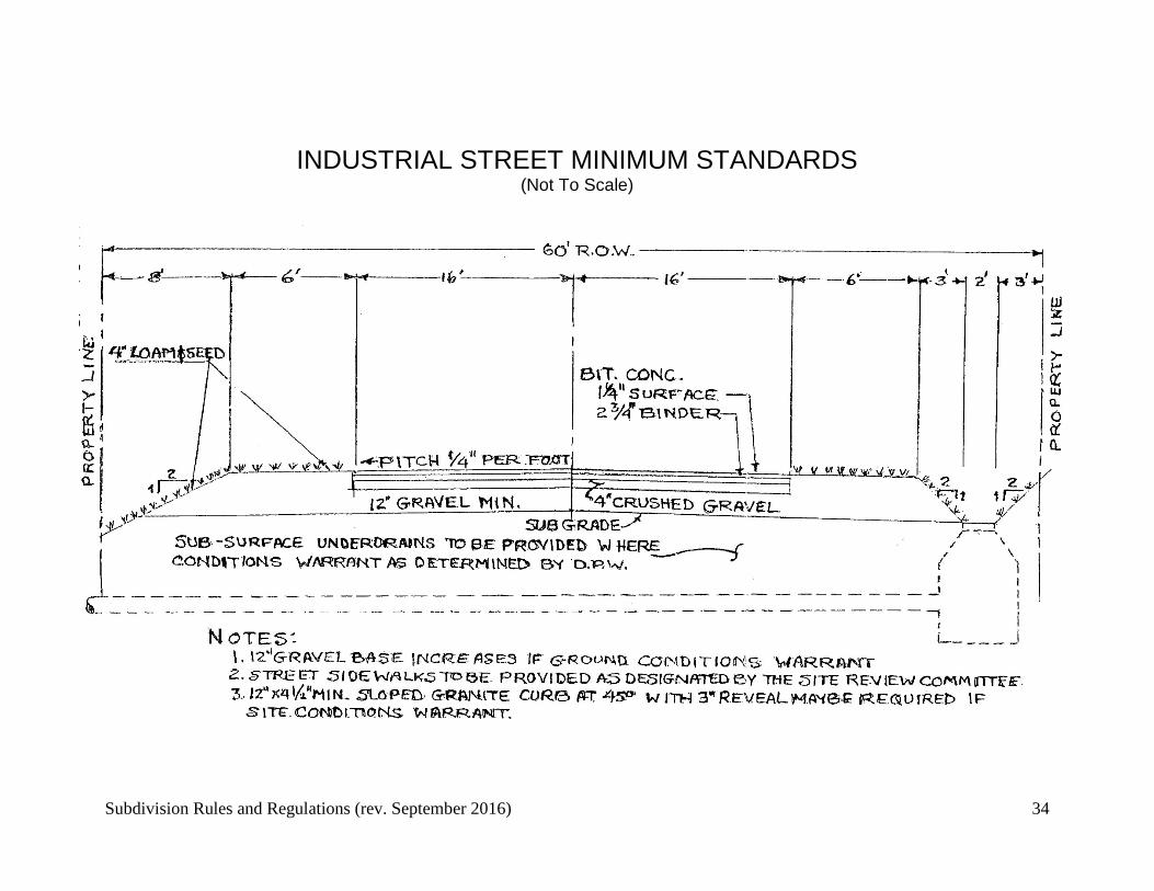
INDUSTRIAL STREET MINIMUM STANDARDS (Not To Scale)
Subdivision Rules and Regulations (rev. September 2016) 35
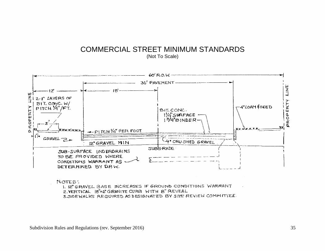
COMMERCIAL STREET MINIMUM STANDARDS (Not To Scale)
Subdivision Rules and Regulations (rev. September 2016) 36
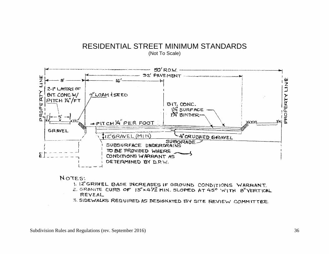
RESIDENTIAL STREET MINIMUM STANDARDS (Not To Scale)