Embed Size (px)
Citation preview

National Marine Fisheries Service SUBMARINE CABLE SURVEY HABITAT and BENTHIC COMMUNITIES Joshua Morel Matos Marine Biologist Clean Ocean Initiative, Inc.
1. Overview The objective of a submarine cable survey for habitat and benthic communities is to provide an evaluation of the aquatic organisms and habitats that follow the path of the submarine cables. During this survey six submarine cables with initial installation in the coast of Puerto Rico are evaluated and analyzed along transects above the cables path. Said submarine cables are identified as SAJ201502643 (SPDCM) known as Mayagüez #1 (MayagüezSanto Domingo), SAJ201502641 (SPDCM) known as Mayagüez #2 (MayagüezDesecheo and DesecheoDominican Republic), SAJ201502638 (SPDCM) known as Aguadilla #3 (RameyGrand Turk), SAJ201502635 (SPDCM) known as Aguadilla #4 (RameyAntigua), SAJ201502640 (SPDCM) known as Ponce #5 (PonceSt. Croix) and SAJ201502639 (SPDCM) known as Ponce #6 (PonceJamaica). Utilizing video recording taken by our dive team we are able to analyze the ocean floor and gather marine ecological data. Even though many biogeographic settings will be included in this survey, our main goal is to provide biotic components (aquatic organisms and habitats) found along the submarine cable path.

2. Methodology
2.1 Survey & Analysis Design This report describes the methods used for survey and analysis of the submarine cables, benthic communities and habitats found, and presents the data sets derived from them. The specific objectives of this research were but not limited to:
1. Compare accuracy of Global Marine submarine cable maps and actual location of submarine cables found by Clean Ocean Initiative technicians.
2. Obtain visual confirmation (if able) of submarine cables. 3. Collect all possible data from surrounding habitats, including ecological settings and
components, on the submarine cable path from each site. 4. Count and identify to species level (where possible) all fauna and flora observed from a
depth of 100’ to 250’. 5. Describe any possible areas where cable removal would cause damage to coral reefs,
endangered species or any Essential Fish Habitats (EFH).
2.2 Materials During the process of conducting the submarine cable survey for habitat and benthic communities various tools and instruments were used.
JW Fishers Pulse 12 boat towed pulse induction metal detector with a with topside control unit
JW Fishers DDW1 Deep Dive Wing depressor wing designed to tow instruments at deeper depths
Lowrance HDS12 Gen3 touchscreen fishfinder / chartplotter Garmin GPSmap 541s Global Marine submarine cable nautical charts GoPro Hero 4 Silver with deep dive housing GoPro Hero 3+ Silver with deep dive housing Intovatec Galaxy Waterproof Video Light Insight Genesis Uploading tool

2.3 Methods Using the most uptodate submarine cable nautical charts of the surrounding waters of Puerto Rico, acquired from Global Marine, we were able to choose search points with specific depths to verify the actual location of each individual coax or telegraph cable and observe them visually if able. Global Marine also provided GIS layering through Google Earth, identifying out of service telegraph submarine cables as red and out of service coaxial submarine cables as green. Only the six submarine cables that come out from Aguadilla, Mayagüez and Ponce (two from each) will be evaluated as part of the survey. The first two cables, SAJ201502643 (SPDCM) known as Mayagüez #1 (MayagüezSanto Domingo) and SAJ201502641 (SPDCM) known as Mayagüez #2 (MayagüezDesecheo and DesecheoDominican Republic), are out of service telegraph submarine cables laid in the west coast of Mayagüez, Puerto Rico. The third and fourth cables, SAJ201502638 (SPDCM) known as Aguadilla #3 (RameyGrand Turk) and SAJ201502635 (SPDCM) known as Aguadilla #4 (RameyAntigua), are out of service coaxial submarine cables laid in the northwest coast of Aguadilla, Puerto Rico. The fifth and sixth of these cables, SAJ201502640 (SPDCM) known as Ponce #5 (PonceSt. Croix) and SAJ201502639 (SPDCM) known as Ponce #6 (PonceJamaica), are out of service telegraph submarine cables laid in the south coast of Ponce, Puerto Rico.

Our dive and research team visited each respective area using a boat towed pulse induction metal detector with a topside control unit (JW Fishers Pulse 12) to confirm submarine cable locations and compare to the charts acquired from Global Marine. Additionally, using linear and zigzag search patterns and grids to chart findings on board the Lowrance HDS12 Gen3 touchscreen fishfinder / chartplotter. Once the chart was plotted, we continued using the JW Fishers DDW1 Deep Dive Wing with custom made fittings to secure two GoPro Hero 4 Silver with deep dive housings and a waterproof video light. Along our plotted waypoints from the Lowrance, we then selected a transect starting from a 100’ depth which would allow us to continue our plotted waypoints up to 250’. In this methodological approach, we are able to save the route taken from the Lowrance showing longitude, latitude and depth/contour, and follow the submarine cable's path from the

surface allowing us to capture video of the habitat, benthic communities and the cable itself (if able) with the Deep Dive Wing. Each cable transect was captured by video a total of three times. The data collected from the Deep Dive Wing was transferred to a computer for video editing and analysis. The Coastal and Marine Ecological Classification Standard (CMECS) was used for organizing information and classifying the environment into biogeographic aquatic settings. And, the reef identification booklets were used for identifying the meiofauna. 3. Results and Discussion 3.1 Ecological Structure Settings & Components Various habitats or ecoregions are defined by climate, geology, and evolutionary history. By knowing the structure setting and components of a habitat, such as structure and characteristics of the water column or geomorphic structural character of the seafloor, one can predetermine various biotic components that may coexist in such habitats. Using the Coastal and Marine Ecological Classification Standard (CMECS) as our structure basis, we can provide a comprehensive framework for organizing information and classify the environment into biogeographic aquatic settings. The following data represents the ecological structure settings and components for each submarine cable. 3.1.1 SAJ201502643 (SPDCM) Mayagüez #1
Water Column Subcomponents: Layer No layers can be described in SAJ201502643 because the initial salvage depth for this particular cable begins at the 320’ depth mark. Salinity Euhaline Water Average between 3535.5ppt (parts per thousand) taken from
various months (Nov, Dec, Jan) from the Caribbean Coastal Ocean Observing System (CariCOOS) webpage (www.caricoos.org) which provides animations of AMSEAS model outputs that are specifically tailored for our regional surface waters and updated on a daily basis.
Temperature Very Warm Water The water temperature ranges between 25°C (77°F) to 30°C (84°F) depending on the month of the year and various weather events. Hydroform Hydroform subcomponents were not taken during our benthic
survey because we lacked the equipment to measure currents

(boundary current, buoyancy flow, deep circulation, mean surface current, etc.), coastal upwelling front, water mass and waves on site, and were not necessary for our survey.
Biochemical Feature No biochemical features can be described in SAJ201502643 (SPDCM) because the initial salvage depth for this particular
cable exceeds the 250’ depth marker, and our dive team wasinstructed to analyze depths from 100’ to 250’.
Geoform Subcomponents Tectonic Setting Neritic Mesopelagic Continental Shelf an underwater landmass which extends from a
continent, resulting in an area of relatively shallow water above the 1000m boundary, also known as a shelf sea.
Physiographic Setting
Continental/Island Shelf that part of the continental margin that is between the shoreline and the continental slope (or a depth or 200 meters when there is no noticeable continental slope); it is characterized by its very gentle slope 0.1°. Island shelves are analogous to the continental shelves, but surround islands.
Geoform Geoform cannot be described in SAJ201502643 because the
initial salvage depth for this particular cable begins at the 320’ depth marker. Certain aspects could be presumed but cannot be confirmed until the Research Vessel with a remote operated vehicle (ROV) investigates the submarine cable.
Substrate Subcomponents: Geologic Fine Unconsolidated Mineral Substrate
Geologic Substrate cannot be described in SAJ201502643 because the initial salvage depth for this particular cable begins at the 320’ depth marker.
3.1.2 SAJ201502641 (SPDCM) Mayagüez #2 3.1.2a Mayagüez Desecheo // First Segment //
Water Column Subcomponents: Layer 100 150’ Marine Offshore Lower Water Column (Marine waters below the
pycnocline (or middepth), between the 30 meter depth contour and the shelf break.)
151 200’ Marine Offshore Lower Water Column (Marine waters below the pycnocline (or middepth), between the 30 meter depth contour and the shelf break.)
200 250’ Marine Oceanic Epipelagic Lower Layer (Within the Epipelagic Layer, the region below the Epipelagic pycnocline if present (of below middepth [100 meters]).
Photosynthesis Can generally occur through this layer although diminishing with
depth to the critical depth for phytoplankton, which represents the point where production and respiration are in balance and no net productivity occurs. The lower bound of the Epipelagic Lower Layer is the bottom of the Epipelagic Layer at 200 meters.)
Salinity Euhaline Water Average between 3535.5ppt (parts per thousand) taken for various
months (Nov, Dec, Jan) from the Caribbean Coastal Ocean Observing System (CariCOOS) webpage (www.caricoos.org) which provides animations of AMSEAS model outputs that are specifically tailored for our regional surface waters and updated on a daily basis.
Temperature Very Warm Water The water temperature ranges between 25°C (77°F) to 30°C (84°F) depending on the month of the year and various weather events.
Hydroform Hydroform subcomponents were not taken during the benthic
survey because we lacked the equipment to measure currents (boundary current, buoyancy flow, deep circulation, mean surface current, etc.), coastal upwelling front, water mass and waves on site and were not necessary for our survey.

Biochemical Feature 100150’ Euphotic Zone (The zone of the water column that is sufficiently
illuminated for photosynthesis to occur) Nepheloid Layer (Layer of water that contains a high concentration
of silt and sediment—usually at the benthicwater column interface. This layer can be nearly a fluid mud. In the deep oceans, the layer can be hundreds of meters thick; in shallower waters with less fine sediments, it can be much thinner (only a few centimeters in places) or absent. Thickness is determined by substrate composition and current shear.)
Marine Snow Aggregation (A concentration of organic material in the ocean water column. Composed of a mix of mineral, dead organic materials, and—sometimes—a rich microbial community. In this feature small particles aggregate through attractive ionic forces and then begin to fall through the water column)
151200’ Euphotic Zone (The zone of the water column that is sufficiently
illuminated for photosynthesis to occur) Nepheloid Layer (Layer of water that contains a high concentration
of silt and sediment—usually at the benthicwater column interface. This layer can be nearly a fluid mud. In the deep oceans, the layer can be hundreds of meters thick; in shallower waters with less fine sediments, it can be much thinner (only a few centimeters in places) or absent. Thickness is determined by substrate composition and current shear.)
Marine Snow Aggregation (A concentration of organic material in the ocean water column. Composed of a mix of mineral, dead organic materials, and—sometimes—a rich microbial community. In this feature small particles aggregate through attractive ionic forces and then begin to fall through the water column)
201250’ Euphotic Zone (The zone of the water column that is sufficiently illuminated for photosynthesis to occur)
Marine Snow Aggregation (A concentration of organic material in the ocean water column. Composed of a mix of mineral, dead organic materials, and—sometimes—a rich microbial community. In this feature small particles aggregate through attractive ionic forces and then begin to fall through the water column)

Geoform Subcomponents Tectonic Setting Neritic Epipelagic Continental Shelf an underwater landmass which extends from a continent, resulting in an area of relatively shallow water above the
200m boundary, also known as a shelf sea.
Physiographic Setting Continental/ Island Shelf Part of the continental margin that is between the shoreline and the continental slope (or a depth or 200 meters when there is no noticeable continental slope); it is characterized by its very gentle slope of 0.1°. Island shelves are analogous to the continental shelves, but surround islands. Geoform Anthropogenic Cable (Structures that serve as linear conduits for electricity or as
supporting lines for other inwater or abovewater infrastructure.) Biogenic Shallow/Mesophotic Coral Reef (Composed mostly of aggregate
coral reef (Continuous, highrelief coral formation that occurs in various shapes and lacks sand channels. This type includes linear coral formations that are oriented parallel to the shelf edge)
Spur and Groove Coral Reef (Habitat having alternating sand and coral formations that are oriented perpendicular to the shore or
bank/shelf escarpment. The coral formations (spurs) of this feature typically have a high vertical relief (compared to pavement with sand channels), and they are separated from each other by 1 5 meters of sand or bare hardbottom (grooves)—although the height and width of these elements may vary considerably. This geoform type typically occurs in the forereef or bank/shelf
escarpment zone))
Geologic FluvioMarine Deposit (Stratified materials (clay, silt, sand, or gravel) formed by both marine and fluvial processes, resulting from nontidal sealevel fluctuations, subsidence, and/or stream
migration (e.g., materials originally deposited in a nearshore environment and subsequently reworked by fluvial processes as the
sea level fell)) Sand Plains – sandy flats found in shallow and deep ocean bottoms

Substrate Subcomponents: Geologic Fine Unconsolidated Mineral Substrate Medium Sand Geologic Substrate surface layer contains no trace of Gravel and
is composed of > 90% Sand, with a median grain size of 0.25 millimeters to < 0.5 millimeters
Coarse Sand Geologic Substrate surface layer contains no trace of Gravel and is composed of > 90% Sand, with a median grain size of 0.5 millimeters to < 1 millimeter.
Silty Sand Geologic Substrate surface layer shows no trace of Gravel and
contains 50% to < 90% Sand; the remaining SiltClay mix is 67% or more Silt.
3.1.2b Desecheo Dominican Republic // Second Segment // Water Column Subcomponents:
Layer 100 150‘ Marine Offshore Lower Water Column (Marine waters below the
pycnocline (or middepth), between the 30 meter depth contour and the shelf break.)
151 200’ Marine Offshore Lower Water Column (Marine waters below the pycnocline (or middepth), between the 30 meter depth contour and the shelf break.)
200 250’ Marine Offshore Lower Water Column (Marine waters below the pycnocline (or middepth), between the 30 meter depth contour and the shelf break.)
Salinity Euhaline Water Average between 3535.5ppt (parts per thousand) taken from various months (Nov, Dec, Jan) from the Caribbean Coastal Ocean Observing System (CariCOOS) webpage (www.caricoos.org) which provides animations of AMSEAS model outputs that are specifically tailored for our regional surface waters and updated on a daily basis. Temperature Very Warm Water The water temperature ranges between 25°C (77°F) to 30°C (84°F) depending on the month of the year and various weather events.

Hydroform Hydroform subcomponents were not taken during our benthic survey because we lacked the equipment to measure currents (boundary current, buoyancy flow, deep circulation, mean surface current, etc.), coastal upwelling front, water mass and waves on site and were not necessary for our survey. Biochemical Feature 100150’ Euphotic Zone (The zone of the water column that is sufficiently illuminated for photosynthesis to occur) 151200’ Euphotic Zone (The zone of the water column that is sufficiently illuminated for photosynthesis to occur) 201250’ Euphotic Zone (The zone of the water column that is sufficiently illuminated for photosynthesis to occur)
Thermocline (The zone of rapid temperature change with depth in the water column, often separating two layers of different,
homogeneous temperature) Geoform Subcomponents Tectonic Setting Neritic Epipelagic Continental Shelf an underwater landmass which extends from a continent, resulting in an area of relatively shallow water above the 200m boundary, also known as a shelf sea. Physiographic Setting Continental/Island Shelf that part of the continental margin that is between the shoreline and the continental slope (or a depth or 200 meters when there is no noticeable continental slope); it is characterized by its very gentle slope of 0.1°. Island shelves are analogous to the continental shelves, but surround islands. Geoform Anthropogenic Cable (Structures that serve as linear conduits for electricity or as supporting lines for other inwater or abovewater infrastructure.)

Biogenic Shallow/Mesophotic Coral Reef (Composed mostly of aggregate coral reef (Continuous, highrelief coral formation that occurs in various shapes and lacks sand channels. This type includes linear coral formations that are oriented parallel to the shelf edge) Spur and Groove Coral Reef (Habitat having alternating sand and coral formations that are oriented perpendicular to the shore or bank/shelf escarpment. The coral formations (spurs) of this feature typically have a high vertical relief (compared to pavement with sand channels), and they are separated from each other by 1 5 meters of sand or bare hardbottom (grooves)—although the height and width of these elements may vary considerably. This geoform type typically occurs in the forereef or bank/shelf escarpment zone)) Geologic Sand Plains – sandy flats found in shallow and deep ocean bottoms Substrate Subcomponents: Geologic Fine Unconsolidated Mineral Substrate
Fine Sand Geologic Substrate surface layer contains no trace of Gravel and composed of > 90% Sand with a median grain size of 0.125 millimeters to < 0.25 millimeters. Medium Sand Geologic Substrate surface layer contains no trace of Gravel and is composed of > 90% Sand, with a median grain size of 0.25 millimeters to < 0.5 millimeters Coarse Sand Geologic Substrate surface layer contains no trace of Gravel and is composed of > 90% Sand, with a median grain size of 0.5 millimeters to < 1 millimeter. Coral Reef Substrate Substrate that is dominated by living or nonliving coral reefs with a median particle size of 4,096 millimeters or greater in any dimension.
3.1.3 SAJ201502638 (SPDCM) Aguadilla #3 Water Column Subcomponents: Layer 100 150’ Marine Offshore Lower Water Column (Marine waters below the
pycnocline (or middepth), between the 30 meter depth contour and the shelf break.)
151 200’ Marine Offshore Lower Water Column (Marine waters below the pycnocline (or middepth), between the 30 meter depth contour and the shelf break.)

200 250’ Marine Oceanic Epipelagic Lower Layer (Within the Epipelagic Layer, the region below the Epipelagic pycnocline if present (or below middepth [100 meters]). Photosynthesis can generally occur
through this layer although diminishing with depth to the critical depth for phytoplankton, which represents the point where production and respiration are in balance and no net productivity occurs. The lower bound of the Epipelagic Lower Layer is the bottom of the Epipelagic Layer at 200 meters, which represents the point where production and respiration are in balance and no net productivity occurs.
Salinity Euhaline Water Average between 3535.5ppt (parts per thousand) taken from various months (Nov, Dec, Jan) from the Caribbean Coastal Ocean Observing System (CariCOOS) webpage (www.caricoos.org) which provides animations of AMSEAS model outputs that are specifically tailored for our regional surface waters and updated on a daily basis. Temperature Very Warm Water The water temperature ranges between 25°C (77°F) to 30°C (84°F) depending on the month of the year and various weather events. Hydroform Hydroform subcomponents were not taken during our benthic survey because we lacked the equipment to measure currents (boundary current, buoyancy flow, deep circulation, mean surface current, etc.), coastal upwelling front, water mass and waves on site and were not necessary for our survey.
Biochemical Feature 100 150’ Euphotic Zone (The zone of the water column that is sufficiently illuminated for photosynthesis to occur) 151 200’ Euphotic Zone (The zone of the water column that is sufficiently illuminated for photosynthesis to occur) 201 250’ Euphotic Zone (The zone of the water column that is sufficiently illuminated for photosynthesis to occur) Marine Snow Aggregation (A concentration of organic material in the ocean water column. Composed of a mix of mineral, dead organic materials, and sometimes a rich microbial community. In this feature small particles aggregate through attractive ionic forces and then begin to fall through the water column.)

Geoform Subcomponents Tectonic Setting Neritic Epipelagic Continental Shelf an underwater landmass which extends from a
continent, resulting in an area of relatively shallow water above the 200m boundary, also known as a shelf sea. Physiographic Setting Continental/Island Shelf that part of the continental margin that is between the shoreline and the continental slope (or a depth or 200 meters when there is no noticeable continental slope); it is characterized by its very gentle slope of 0.1°. Island shelves are analogous to the continental shelves, but surround islands. Geoform AnthropogenicCable (Structures that serve as linear conduits for electricity or as supporting lines for other inwater or abovewater infrastructure.) Biogenic Shallow/Mesophotic Coral Reef (Composed mostly of aggregate coral reef (Continuous, highrelief coral formation that occurs in various shapes and lacks sand channels. This type includes linear coral formations that are oriented parallel to the shelf edge)) Spur and Groove Coral Reef (Habitat having alternating sand and coral formations that are oriented perpendicular to the shore or bank/shelf escarpment. The coral formations (spurs) of this feature typically have a high vertical relief (compared to pavement with sand channels), and they are separated from each other by 1 5 meters of sand or bare hardbottom (grooves)—although the height and width of these elements may vary considerably. This geoform type typically occurs in the fore reef or bank/shelf escarpment zone)) Geologic Sand Plains – sandy flats found in shallow and deep ocean bottoms Substrate Subcomponents: Geologic Fine Unconsolidated Mineral Substrate
Coarse Sand Geologic Substrate surface layer contains no trace of Gravel and is composed of > 90% Sand, with a median grain size of 0.5 millimeters to < 1 millimeter.
Coral Reef Substrate Substrate that is dominated by living or nonliving coral reefs with a median particle size of 4,096 millimeters or greater in any dimension.

3.1.4 SAJ201502635 (SPDCM) Aguadilla #4 Water Column Subcomponents: Layer 100 150’ Marine Offshore Lower Water Column (Marine waters below the pycnocline (or middepth), between the 30 meter depth contour
and the shelf break.) 151 200’ Marine Offshore Lower Water Column (Marine waters below the pycnocline (or middepth), between the 30 meter depth contour
and the shelf break.) 200 250’ Marine Offshore Lower Water Column (Marine waters below the pycnocline (or middepth), between the 30 meter depth contour
and the shelf break.)
Salinity Euhaline Water Average between 3535.5ppt (parts per thousand) taken from various months (Nov, Dec, Jan) from the Caribbean Coastal Ocean Observing System (CariCOOS) webpage (www.caricoos.org) which provides animations of AMSEAS model outputs that are specifically tailored for our regional surface waters and updated on a daily basis. Temperature Very Warm Water The water temperature ranges between 25°C (77°F) to 30°C (84°F) depending on the month of the year and various weather events. Hydroform Hydroform subcomponents were not taken during our benthic survey because we lacked the equipment to measure currents (boundary current, buoyancy flow, deep circulation, mean surface current, etc.), coastal upwelling front, water mass and waves on site and were not necessary for our survey. Biochemical Feature 100 150’ Euphotic Zone (The zone of the water column that is sufficiently illuminated for photosynthesis to occur) 151 200’ Euphotic Zone (The zone of the water column that is sufficiently illuminated for photosynthesis to occur)

201 250’ Euphotic Zone (The zone of the water column that is sufficiently illuminated for photosynthesis to occur)
Marine Snow Aggregation (A concentration of organic material in the ocean water column. Composed of a mix of mineral, dead organic materials, and sometimes a rich microbial community. In this feature small particles aggregate through attractive ionic forces and then begin to fall through the water column)
Geoform Subcomponents Tectonic Setting
Neritic Epipelagic Continental Shelf An underwater landmass which extends from a continent, resulting in an area of relatively shallow water above the 200m boundary, also known as a shelf sea
Physiographic Setting Continental/Island Shelf
that part of the continental margin that is between the shoreline and the continental slope (or a depth or 200 meters when there is no noticeable continental slope); it is characterized by its very gentle slope of 0.1°. Island shelves are analogous to the continental shelves, but surround islands.
Geoform
Anthropogenic Cable (Structures that serve as linear conduits for electricity or as
supporting lines for other inwater or abovewater infrastructure.)

Biogenic Shallow/Mesophotic Coral Reef (Composed mostly of aggregate coral reef (Continuous, highrelief coral formation that occurs in various shapes and lacks sand channels. This type includes linear coral formations that are oriented parallel to the shelf edge)
Spur and Groove Coral Reef (Habitat having alternating sand and coral formations that are oriented perpendicular to the shore or bank/shelf escarpment. The coral formations (spurs) of this feature typically have a high vertical relief (compared to pavement with sand channels), and they are separated from each other by 1 5 meters of sand or bare hardbottom (grooves)—although the height and width of these elements may vary considerably. This geoform type typically occurs in the forereef or bank/shelf escarpment zone))
Geologic Sand Plains Sandy flats found in shallow and deep ocean bottoms Substrate Subcomponents: Geologic Fine Unconsolidated Mineral Substrate
Medium Sand Geologic Substrate surface layer contains no trace Gravel and is composed of > 90% Sand, with a median grain size of 0.25 millimeters to < 0.5 millimeters
Coarse Sand Geologic Substrate surface layer contains no trace of Gravel and is composed of > 90% Sand, with a median grain size of 0.5 millimeters to < 1 millimeter.
Coral Reef Substrate Substrate that is dominated by living or nonliving coral reefs with a median particle size of 4,096 millimeters or greater in any dimension.
3.1.5 SAJ201502640 (SPDCM) Ponce #5
Water Column Subcomponents: Layer No layers can be described in SAJ201502640 because the initial salvage depth for this particular cable begins at the 606’ depth marker. Salinity Euhaline Water Average between 3535.5ppt (parts per thousand) taken from various months (Nov, Dec, Jan) from the Caribbean Coastal Ocean Observing System (CariCOOS) webpage (www.caricoos.org) which provides animations of AMSEAS model outputs that are specifically tailored for our regional surface waters and updated on a daily basis.

Temperature Very Warm Water The water temperature ranges between 25°C (77°F) to 30°C (84°F) depending on the month of the year and various weather events. Hydroform Hydroform subcomponents were not taken during our benthic survey because we lacked the equipment to measure currents (boundary current, buoyancy flow, deep circulation, mean surface current, etc.), coastal upwelling front, water mass and waves on site and were not necessary for our survey. Biochemical Feature No biochemical features can be described in SAJ201502643 because the initial salvage depth for this particular begins at the 606’ depth marker. Geoform Subcomponents Tectonic Setting Transform Continental Margin A feature defined by the transform fault that develops during continental rifting. These margins differ from rifted or passive margins in two key ways; they have a narrow continental shelf (less than 30 kilometers) and a steep oceancontinent transition zone. Physiographic Setting
Shelf Break The slope discontinuity (rapid change in gradient) of 3° or greater that occurs at the outer edge of the continental shelf. This boundary generally occurs at a depth between 100200 meters and forms the boundary between the Marine Offshore and Oceanic Subsystems.
Geoform Geoform cannot be described in SAJ201502643 because the
initial salvage depth for this particular cable begins at the 606’ depth marker. Certain aspects could be presumed but cannot be confirmed until our Research Vessel with a remote operated vehicle (ROV) investigates the submarine cable.
Substrate Subcomponents: Geologic Fine Unconsolidated Mineral Substrate
Geologic Substrate cannot be described in SAJ201502643 because the initial salvage depth for this particular cable exceeds the 250’ depth marker.

3.1.6 SAJ201502639 (SPDCM) Ponce #6 Water Column Subcomponents: Layer 100 150’ Marine Offshore Lower Water Column (Marine waters below the pycnocline (or middepth), between the 30 meter depth contour
and the shelf break.) 151 200’ Marine Offshore Lower Water Column (Marine waters below the
pycnocline (or middepth), between the 30 meter depth contour and the shelf break.)
200 250’ Marine Oceanic Epipelagic Lower Layer (Within the Epipelagic Layer, the region below the Epipelagic pycnocline if present (or below middepth [100 meters]). Photosynthesis can generally occur through this layer although diminishing with depth to the critical depth for phytoplankton, which represents the point where
production and respiration are in balance and no net productivityoccurs. The lower bound of the Epipelagic Lower Layer is the bottom of the Epipelagic Layer at 200 meters.
Salinity Euhaline Water Average between 3535.5ppt (parts per thousand) taken from various months (Nov, Dec, Jan) from the Caribbean Coastal Ocean Observing System (CariCOOS) webpage (www.caricoos.org) which provides animations of AMSEAS model outputs that are specifically tailored for our regional surface waters and updated on a daily basis. Temperature Very Warm Water The water temperature ranges between 25°C (77°F) to 30°C (84°F) depending on the month of the year and various weather events. Hydroform Hydroform subcomponents were not taken during our benthic survey because we lacked the equipment to measure currents (boundary current, buoyancy flow, deep circulation, mean surface current, etc.), coastal upwelling front, water mass and waves on site and were not necessary for our survey.

Biochemical Feature 100 150’ Euphotic Zone (The zone of the water column that is sufficiently illuminated for photosynthesis to occur) Nepheloid Layer (Layer of water that contains a high concentration of silt sediment—usually at the benthicwater column interface. This layer can be nearly a fluid mud. In the deep oceans, the layer can be hundreds of meters thick; in shallower waters with less fine sediments, it can be much thinner (only a few centimeters in places) or absent. Thickness is determined by substrate composition and current shear.) Marine Snow Aggregation (A concentration of organic material in the ocean water column. Composed of a mix of mineral, dead organic materials, and sometimes a rich microbial community. In this feature small particles aggregate through attractive ionic forces and then begin to fall through the water column) 151 200’ Euphotic Zone (The zone of the water column that is sufficiently illuminated for photosynthesis to occur) Nepheloid Layer (Layer of water that contains a high concentration of silt and sediment usually at the benthicwater column interface. This layer can be nearly a fluid mud. In the deep oceans, the layer can be hundreds of meters thick; in shallower waters with less fine sediments, it can be much thinner (only a few centimeters in places) or absent. Thickness is determined by substrate composition and current shear.) Marine Snow Aggregation (A concentration of organic material in the ocean water column. Composed of a mix of mineral, dead organic materials, and sometimes a rich microbial community. In this feature small particles aggregate through attractive ionic forces and then begin to fall through the water column)

201 250’ Euphotic Zone (The zone of the water column that is sufficiently illuminated for photosynthesis to occur) Nepheloid Layer (Layer of water that contains a high concentration of silt and sediment usually at the benthicwater column interface. This layer can be nearly a fluid mud. In the deep oceans, the layer can be hundreds of meters thick; in shallower waters with less fine sediments, it can be much thinner (only a few centimeters in places) or absent. Thickness is determined by substrate composition and current shear.)
Marine Snow Aggregation (A concentration of organic material in the ocean water column. Composed of a mix of mineral, dead organic materials, and sometimes a rich microbial community. In this feature small particles aggregate through attractive ionic forces and then begin to fall through the water column) Geoform Subcomponents Tectonic Setting Transform Continental Margin A feature defined by the transform fault that develops during continental rifting. These margins differ from rifted or passive margins in two key ways; they have a narrow continental shelf (less than 30 kilometers) and a steep oceancontinent transition zone. Physiographic Setting
Shelf Break The slope discontinuity (rapid change in gradient) of 3° or greater that occurs at the outer edge of the continental shelf. The boundary generally occurs at a depth between 100200 meters and forms the boundary between the Marine Offshore and Oceanic Subsystems.
Geoform Anthropogenic Cable Structures that serve as linear conduits for electricity or as supporting lines for other inwater or abovewater infrastructure.
Dredge Deposit A subaqueous area that is substantially shallower than the surrounding area, which resulted from the deposition of
materials from dredging and dumping.

Biogenic Shallow/Mesophotic Coral Reef (Composed mostly of aggregate coral reef (Continuous, highrelief coral formation that occurs in various shapes and lacks sand channels. This type includes linear coral formations that are oriented parallel to the shelf edge)
Spur and Groove Coral Reef (Habitat having alternating sand and coral formations that are oriented perpendicular to the shore or bank/shelf escarpment. The coral formations (spurs) of this feature typically have a high vertical relief (compared to pavement with sand channels), and they are separated from each other by 1 5 meters of sand or bare hard bottom (grooves)—although the height and width of these elements may vary considerably. This geoform type typically occurs in the fore reef or bank/shelf escarpment zone))
Geologic FluvioMarine Deposits (Stratified materials (clay, silt, sand, or gravel) formed by both marine and fluvial processes, resulting from nontidal sealevel fluctuations, subsidence, and/or stream migration (e.g., materials originally deposited in a nearshore environment and subsequently reworked by fluvial processes as the sea level fell)). Shelf Break The slope discontinuity (rapid change in gradient) of
3° or greater that occurs at the outer edge of the continental shelf. This boundary generally occurs at a depth between 100200 meters and forms the boundary between the Marine Offshore and Oceanic Subsystems.
Substrate Subcomponents: Geologic Fine Unconsolidated Mineral Substrate
Silty Sand Geologic Substrate surface layer shows no trace of Gravel and contains 50% to < 90% Sand; the remaining SiltClay mid 67% or more Silt.

3.2 Benthic Biota All observed biotic components, with the exception of planktonic biota, were counted and identified to species level (if possible). Through this identification method it is easy to better understand the habitat and if any area could potentially be an Essential Fish Habitat (EFH). In the occurrence where there are vast quantities of the same species the acronym TMTC will be applied meaning Too Many To Count. 3.2.1 SAJ201502643 (SPDCM) Mayagüez #1 The benthic biota could not be described in SAJ201502643 because the initial salvage depth for this particular cable begins at the 320’ depth marker. Certain biological aspects could be presumed but cannot be confirmed until our Research Vessel with a remotely operated vehicle (ROV) investigates the submarine cable in this particular area. 3.2.2 SAJ201502641 (SPDCM) Mayagüez #2 Because of the distance between Mayagüez and Desecheo Island, and the fact that the submarine cable path continues with an entirely new segment at Desecheo waters, with regards to the benthic survey each submarine cable is described in segments. 3.2.2a Mayagüez Desecheo // First Segment // Phylum Annelida Thousands of volcanic coneshaped mound were seen which belong to a type of segmented worm better known as lugworms, that burrow beneath the sand to digest organic debris and blow excreted sand from burrows by water pressure, forming the conical mounds. Every sand plain found in the Mayagüez area contained thousands of these mounds.
Common Name Scientific Name
Found at 100’150’
Found at 151’200’
Found at 201’250’
Total Found
Lugworm Arenicola sp. TMTC TMTC TMTC TMTC
Phylum Chlorophyta Very little aquatic plants and algae could be observed after 100’ depth, but some green algae were seen below this depth.
Common Name Scientific Name
Found at 100’150’
Found at 151’200’
Found at 201’250’
Total Found
Mermaid's Fan Udotea sp. 10 0 0 10

Phylum Mollusca Some species of Gastropods were easily observed on the ocean floor from their clearly seen large shells and various track over the sandy and silty bottoms.
Common Name Scientific Name
Found at 100’150’
Found at 151’200’
Found at 201’250’
Total Found
Queen Conch Strombus gigas
5 0 1 6
Roostertail Conch
Strombus gallus
0 0 2 2
Phylum Cnidaria From the phylum Cnidaria we were able to identify two classes: Hydrozoa (Hydroids) and Anthozoa (Gorgonians and Sea Pens). Hydroids found were counted as clusters instead of individuals.
Common Name Scientific Name Found at 100’150’
Found at 151’200’
Found at 201’250’
Total Found
Branching Hydroid
Sertularella speciosa 6 11 28 45
Unbranched Hydroid
Cnidoscyphus marginatus
0 0 4 4
Feather Sea Pen Unidentified species 0 1 2 3
Devil's Sea Whip
Ellisella barbadensis 8 14 0 22
Bipinnate Sea Plume
Pseudopterogorgia bipinnata
0 1 4 5
Slitpore Sea Rod
Plexaurella sp. 0 4 3 7
Sea Fan Leptogorgia sp. 0 0 11 11
Rough Sea Plume
Muriceopsis flavida 0 0 1 1

Phylum Porifera Sponges dominated the submarine cable path in Mayagüez area. What is believed to be encrusting sponges were also observed, but the information was not added to the survey because the distance and picture quality of the video did not permit identification and they can easily be confused with bryozoans, tunicates or other small hard corals.
Common Name Scientific Name Found at 100’150’
Found at 151’200’
Found at 201’250’
Total Found
Row Pore Rope Sponge
Aplysina cauliformis
27 9 6 42
Netted Barrel Sponge
Verongula gigantea
4 2 0 6
Giant Barrel Sponge
Xestospongia muta
3 2 17 22
Brown Tube Sponge
Ageles conifera 13 8 23 44
Brown Encrusting Octopus Sponge
Ectyoplasia ferox 0 1 0 1
Brown Variable Sponge
Cliona Varians 0 2 0 2
Scattered Pore Rope Sponge
Aplysina fulva 0 6 14 20
Convoluted Barrel Sponge
Aplysina lacunosa 0 0 2 2
Yellow Tube Sponge
Aplysina fistularis 0 0 9 9
Black Ball Sponge Ircinia strobilina 0 0 1 1
Phylum Chordata Urochordata Because most tunicates tend to be small in size, not that many were observed during the survey. Some overgrowing tunicates can easily be confused from a distance as encrusting sponges,
bryozoans or small hard corals. No overgrowing tunicates were counted because of these similarities.
Common Name Scientific Name Found at 100’150’
Found at 151’200’
Found at 201’250’
Total Found
Reef Tunicate Rhopalaea abdominalis
0 0 1 1
Phylum Chordata Osteichthyes Many fish species were observed but could not be identified because of the distance and size of the fish. Those that could be identified are listed in the following table. All fish spotted in our videos had debris presence in its surroundings.
Common Name Scientific Name Found at 100’150’
Found at 151’200’
Found at 201’250’
Total Found
French Angelfish
Pomacanthus paru 2 0 0 2
Snapper Lutjanus sp. 0 1 0 1
Coney Cephalopholis fulvus 0 3 7 10
Blue Runner Caranx crysos 0 0 4 4
Jackknife Fish Equetus lanceolatus 0 0 1 1
Grunt Haemulon sp. 0 0 24 24
Almaco Jack Seriola rivoliana 0 0 1 1
3.2.2b Desecheo Dominican Republic // Second Segment // Phylum Chlorophyta With Desecheo's extremely clear waters we were able to observe a high amount of marine plants growing between 100’ and 150’. It consisted entirely on green algaethat spread across the sand plains until it reached the reef substrate.

Common Name Scientific Name
Found at 100’150’
Found at 151’200’
Found at 201’250’
Total Found
Stalked Lettuce Leaf Alga
Halimeda tuna
22 15 0 37
Mermaid's Fans Udotea sp. TMTC TMTC 0 TMTC
Ovalblade Alga Caulerpa prolifera
9 TMTC 0 TMTC
Phylum Cnidaria It was strange that even with a high visibility margin in the 250’ depth practically no octocorals, hydrocorals or stony corals were observed in our videos. Closer and higher definition video might help identify small cnidarians in the reef substrate but only one could be observed in our data.
Common Name
Scientific Name Found at 100’150’
Found at 151’200’
Found at 201’250’
Total Found
Devil's Sea Whip
Ellisella barbadensis
0 0 2 2
Phylum Porifera Sponges dominated the submarine cable path in the Desecheo Island area when the reef substrate commenced. What is believed to be encrusting sponges were also observed in high numbers, but the information was not added to the survey because the distance and picture quality of the video did not permit identification and they can easily be confused with bryozoans, tunicates or other small hard corals.

Common Name Scientific Name Found at 100’150’
Found at 151’200’
Found at 201’250’
Total Found
Giant Barrel Sponge
Xestospongia muta 1 47 38 86
Netted Barrel Sponge
Verongula gigantea 0 2 3 5
Leathery Barrel Sponge
Geodia neptuni 0 5 4 9
Brown Encrusting Octopus Sponge
Ectyoplasia ferox 0 22 14 36
Scattered Pore Rope Sponge
Aplysina fulva 0 11 4 15
Azure Vase Sponge
Callyspongia plicifera
0 5 2 7
Brown Tube Sponge
Ageles conifera 0 21 19 40
Convoluted Barrel Sponge
Aplysina lacunosa 0 3 1 4
Branching Tube Sponge
Pseudoceratina crassa
0 12 4 16
Yellow Tube Sponge
Aplysina fistularis 0 2 8 10
Branching Vase Sponge
Callyspongia vaginalis
0 2 1 3
Phylum Chordata Osteichthyes Many fish species were observed but could not be identified because of the distance and size of the fish. Those that could be identified are listed in the following table. Most fish were observed swimming 10’ or higher from the ocean floor.

Common Name Scientific Name Found at 100’150’
Found at 151’200’
Found at 201’250’
Total Found
Flying Gurnard Dactylopterus volitans
1 0 0 1
Sand Tilefish Malacanthus plumieri
5 0 0 5
Trunkfish Lactophrys sp. 1 0 0 1
Blue Runner Caranx crysos 1 0 0 1
Rainbow Runner Elegantis bipinnulata
1 0 0 1
Bar Jack Caranx ruber 1 4 0 5
Ocean Triggerfish
Canthidermis sufflamen
7 8 0 15
Ocean Surgeonfish
Acanthurus bahianus
0 2 0 2
Whitespotted Filefish
Cantherhines macrocerus
0 1 0 1
Great Barracuda Sphyraena barracuda
0 3 0 3
Cobia Rachycentron canadum
0 2 0 2
3.2.3 SAJ201502638 (SPDCM) Aguadilla #3 Phylum Annelida From the depth of 170’ you can observe on the videos various coneshaped mounds with small orifices close to them. These are clear signs of segmented worms burrowing in the sand plains.
Common Name Scientific Name
Found at 100’150’
Found at 151’200’
Found at 201’250’
Total Found
Lugworm Arenicola sp.
0 TMTC TMTC TMTC

Phylum Cnidaria A small presence of octocorals and stony corals was observed after the 100’ depth mark
Common Name Scientific Name Found at 100’150’
Found at 151’200’
Found at 201’250’
Total Found
Corky Sea Finger Briareum asbestinum
2 0 0 2
Porous Sea Rod Pseudoplexaura sp.
0 1 0 1
Knobby Brain Coral
Diploria clivosa 1 0 0 1
Phylum Porifera Same as Mayagüez and Desecheo, a higher number of sponges were observed compared to any other species of fauna found in the area. What is believed to be encrusting sponges were also observed in high numbers, but the information was not added to the survey because the distance and picture quality of the video did not permit identification and they can easily be confused with bryozoans, tunicates or other small hard corals.

Common Name Scientific Name Found at 100’150’
Found at 151’200’
Found at 201’250’
Total Found
Giant Barrel Sponge
Xestospongia muta 33 6 0 39
Convoluted Barrel Sponge
Aplysina lacunosa 3 1 0 4
Nettled Barrel Sponge
Verongula gigantea 2 2 0 4
Azure Vase Sponge
Callyspongia plicifera
3 0 0 3
Variable Boring Sponge
Aka coralliphaga 1 0 0 1
Scattered Pore Rope Sponge
Aplysina fulva 3 2 0 5
Row Pore Rope Sponge
Aplysina cauliformis 8 3 0 11
Erect Rope Sponge
Amphimedon compressa
1 3 0 4
Branching Tube Sponge
Pseudoceratina crassa
0 1 0 1
Stovepipe Sponge
Aplysina archeri 0 1 0 1
Loggerhead Sponge
Spheciospongia vesparium
0 1 0 1
Phylum Chordata Osteichthyes The fish seen at Aguadilla #3 are common throughout the coasts of Puerto Rico and can be observed in shallow reefs or around coral substrate.

Common Name Scientific Name Found at 100’150’
Found at 151’200’
Found at 201’250’
Total Found
Banded Butterflyfish
Chaetodon striatus 2 0 0 2
Squirrelfish Holocentrus adscensionis
1 1 0 2
Bicolor Damselfish
Stegastes partitus 4 0 0 4
Coney Cephalopholis fulvus
2 1 0 3
Snapper Lutjanus sp. 0 2 0 2
Gray Angelfish Pomacanthus arcuatus
0 2 0 2
Lionfish Pterois volitans 0 2 0 2
Atlantic Spadefish
Chaetodipterus faber
0 0 2 2
Blue Tang Acanthurus coeruleus
1 0 0 1
French Angelfish
Pomacanthus paru 0 2 0 2
3.2.4 SAJ201502635 (SPDCM) Aguadilla #4 Aguadilla #4 shares most of its biotic and ecological characteristics with Aguadilla #3 because of its close proximity to each other. The biggest difference is its great sand plain through the cables path, extending over 3 miles always between a depth of 110’140’. Phylum Annelida Numbers too many to count in its sand plains.
Common Name Scientific Name Found at 100’150’
Found at 151’200’
Found at 201’250’
Total Found
Lugworm Arenicola sp. TMTC TMTC TMTC TMTC

Phylum Chlorophyta In the north coast of Aguadilla the water are clear and the rays of the sun easily reach the ocean floor. Thanks to this clarity many patches of algae could be observed during the sand plains.
Common Name Scientific Name Found at 100’150’
Found at 151’200’
Found at 201’250’
Total Found
Ovalblade Alga Caulerpa prolifera
TMTC 0 0 TMTC
Phylum Cnidaria A small presence of octocorals and stony corals was observed after the 100’ depth mark.
Common Name Scientific Name Found at 100’150’
Found at 151’200’
Found at 201’250’
Total Found
Sea Rods Plexauridae 6 0 0 6
Phylum Porifera Any area where reef substrate was present, the presence of sponges could be found.

Common Name Scientific Name Found at 100’150’
Found at 151’200’
Found at 201’250’
Total Found
Giant Barrel Sponge
Xestospongia muta
31 3 0 34
Netted Barrel Sponge
Verongula gigantea
8 0 0 8
Convoluted Barrel Sponge
Aplysina lacunosa 4 0 0 4
Yellow Tube Sponge
Aplysina fistularis 15 0 0 15
Row Pore Rope Sponge
Aplysina cauliformis
16 2 0 18
Scattered Pore Rope Sponge
Aplysina fulva 6 1 0 7
Erect Rope Sponge
Amphimedon compressa
2 0 0 2
Phylum Chordata Osteichthyes Most fish species were observed in areas where reef substrate was present. During the various miles of sand plains almost no fish were observed.

Common Name Scientific Name Found at 100’150’
Found at 151’200’
Found at 201’250’
Total Found
Squirrelfish Holocentrus adscensionis
5 0 0 5
Yellowtail Snapper
Ocyurus chrysurus 0 1 0 1
Coney Cephalopholis fulvus
3 2 0 5
Red Hind Epinephelus guttatus
4 0 0 4
Queen Triggerfish
Balistes vetula 1 0 0 1
Black Durgon Melichthys niger 3 0 0 3
Sand Tilefish Malacanthus plumieri
4 0 0 4
Snapper Lutjanus sp. 0 1 0 1
French Angelfish
Pomacanthus paru 2 0 0 2
Lionfish Pterois volitans 1 0 0 1
3.2.5 SAJ201502640 (SPDCM) Ponce #5 The benthic biota could not be described in SAJ201502643 because the initial salvage depth for this particular cable begins at the 606’ depth marker. Certain biological aspects could be presumed but cannot be confirmed until our Research Vessel with a remote operated vehicle (ROV) investigates the submarine cable area. 3.2.6 SAJ201502639 (SPDCM) Ponce #6 Constant winds, strong currents, and high concentrations of marine snow (detritus) made it nearly impossible to observe the benthic biota in Ponce #6. Only species that are greater than 8 inches could be taken into account between the depths of 100’185’. All data obtained after 185’ could not be used because the high concentrations of marine snow limited the visibility to less than one foot.

Phylum Cnidaria A small presence of octocorals and a small colony of black corals were observed after the 100’ depth mark near the shelf break. Please note that Clean Ocean’s operation will avoid the small colony of black coral. Please refer to study analysis section 3.3 Ponce #6.
Common Name Scientific Name Found at 100’150’
Found at 151’200’
Found at 201’250’
Total Found
Sea Rods Plexauridae 3 0 0 3
Wire Coral Cirrhipathes leutkeni
17 0 0 17
Phylum Porifera With layers of accumulation of detritus and particulates within the lower water column it was rare to observe any sponges within a very small area.
Common Name Scientific Name Found at 100’150’
Found at 151’200’
Found at 201’250’
Total Found
Giant Barrel Sponge
Xestospongia muta
8 2 0 10
Scattered Pore Rope Sponge
Aplysina fulva 2 0 0 2
Netted Barrel Sponge
Verongula gigantea
1 0 0 1
Yellow Tube Sponge
Aplysina fistularis
5 0 0 5
Phylum Chordata Osteichthyes Low visibility within the lower water column did not permit the identification of many fish species.
Common Name
Scientific Name Found at 100’150’
Found at 151’200’
Found at 201’250’
Total Found
Coney Cephalopholis fulvus
2 0 0 2
Yellowtail Snapper
Ocyurus chrysurus 1 0 0 1
Grunt Haemulon sp. 5 4 0 9
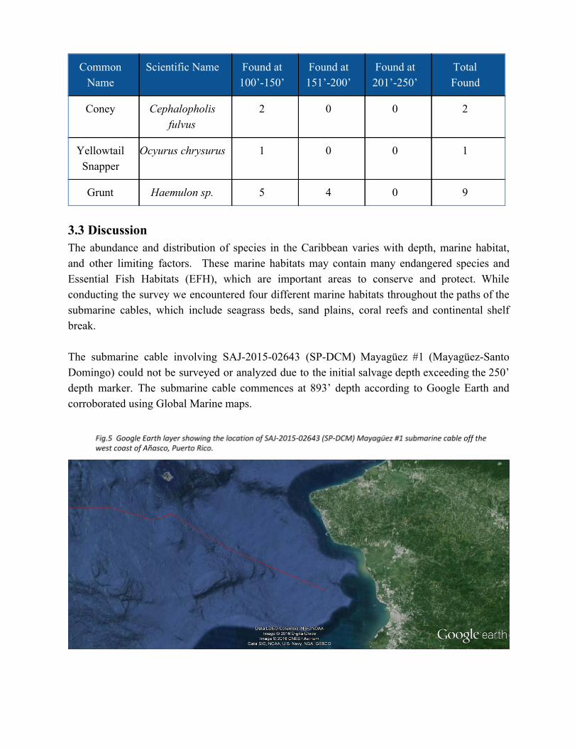
3.3 Discussion The abundance and distribution of species in the Caribbean varies with depth, marine habitat, and other limiting factors. These marine habitats may contain many endangered species and Essential Fish Habitats (EFH), which are important areas to conserve and protect. While conducting the survey we encountered four different marine habitats throughout the paths of the submarine cables, which include seagrass beds, sand plains, coral reefs and continental shelf break. The submarine cable involving SAJ201502643 (SPDCM) Mayagüez #1 (MayagüezSanto Domingo) could not be surveyed or analyzed due to the initial salvage depth exceeding the 250’ depth marker. The submarine cable commences at 893’ depth according to Google Earth and corroborated using Global Marine maps.

The second submarine cable, SAJ201502641 (SPDCM) known as Mayagüez #2 (MayagüezDesecheo and DesecheoDominican Republic), was divided into two segments. The first segment laid begins in the west coast in Mayaguez with an end point in Desecheo Island. The second segment laid [and separate from first segment] begins in Desecheo Island with an end point in the Dominican Republic. The MayagüezDesecheo survey from 100’ 250’ showed two marine habitats: sand plains and a small adjacent coral reef. Most of the transect consisted of silty sand plains believed to be the consequence from three rivers (Guanajibo, Yagüez, Añasco) depositing sediment into Mayagüez Bay. Many signs of segmented worms and mollusks covered the benthic surface or the silty sand, which also contained woody debris with various inhabitants including sponges, hydroids and some fish species. The small reef was observed after the 150’ mark in our sonar. High amount of sediment and marine snow in the water column limited the amount of sunlight needed for many hermatypic species usually found at these depths. These factors did not completely limit the capabilities of some soft corals (octocorals) growing in this reef, but made it possible for sponges to be the dominant species growing in the small reef. No endangered species or EFH were encountered during the survey of this submarine cable and its surrounding habitats. The submarine cable was not located with video during the survey. Little to no impact would occur if the submarine cable’s salvage point commences at the 320’ mark. Mayagüez’s end salvage at Desecheo Island would occur around the 320’ mark to minimize any disturbance or impact to the inshore coral reefs.
The Desecheo Dominican Republic survey from 100’ – 250’ showed three marine habitats: sandy plains, seagrass beds and coral reef. The first 40’ of the survey consisted of a sand plain with the occasional fish or algae. The plain was followed by a big seagrass bed of Ovalblade alga until a coral reef was found lasting until the end of the survey. No marine snow presence was seen and sunlight illuminated the ocean floor, with visibility exceeding 100’ from the ocean
surface. Closer and higher definition video might have helped identify small cnidarians in the reef substrate that included octocorals, hydrocorals and stony corals. Hundreds of sponges could be seen at the coral reef, dominating the macrofauna. No endangered species or EFH were encountered during the survey of this submarine cable and its surrounding habitats. The submarine cable was not located with video during the survey, but was located by divers until the 80’ depth mark (seen in videos) where it goes below the sand. Some impact would occur if the submarine cable’s salvage point commences at the 100’ mark, but more damage could be presented if the initial salvage point is below 200’. Divers can easily reach the cables at 100’ to 120’ depths for cutting and prepping for the attachment of the cables to the SLay barge but would still create some impact to surrounding corals and habitats. Should we grab the cables at 320’ depths the method would be using the work class ROV system that would use water jets to expose the cable and in turn would grapple via the Barge Crane and pull the cable straight up resulting in some disturbance in both directions but only reaching up to 250’ depths were little or no corals grow.
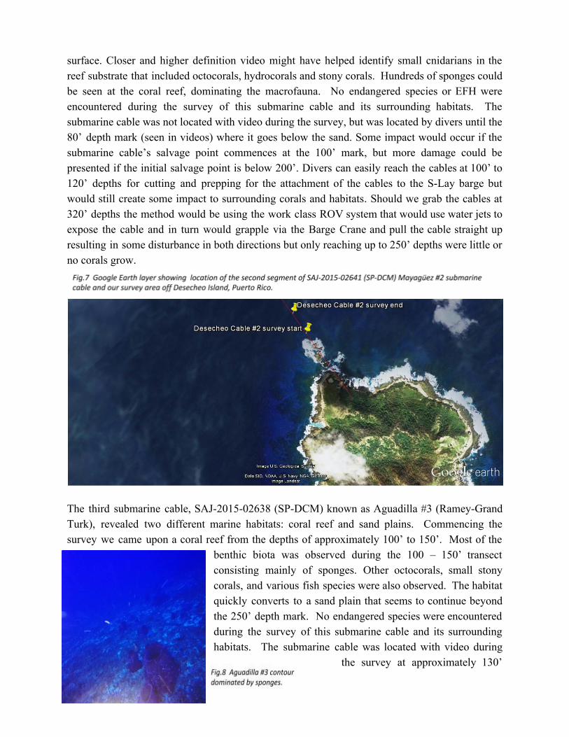
The third submarine cable, SAJ201502638 (SPDCM) known as Aguadilla #3 (RameyGrand Turk), revealed two different marine habitats: coral reef and sand plains. Commencing the survey we came upon a coral reef from the depths of approximately 100’ to 150’. Most of the
benthic biota was observed during the 100 – 150’ transect consisting mainly of sponges. Other octocorals, small stony corals, and various fish species were also observed. The habitat quickly converts to a sand plain that seems to continue beyond the 250’ depth mark. No endangered species were encountered during the survey of this submarine cable and its surrounding habitats. The submarine cable was located with video during
the survey at approximately 130’

but could not be found with video afterwards. Initial salvage depth was proposed for 134’ creating minimal impact to the surrounding areas, and also coinciding with the found submarine cable segment. Minimization and conservation plans are being developed to minimize any impact and replant any sponge or coral detached from the cable or surrounding areas while the submarine cable is being removed.

The fourth submarine cable, SAJ201502635 (SPDCM) known as Aguadilla #4 (RameyAntigua), also presented two marine habitats: spur and grove coral reef and sand plain. This submarine cable transect stretches over five miles in distance, with an average depth of 135’. The first half a mile consisted of a spur and groove reef with many sponge and fish species. The rest of the transect consisted of a sand plains with segmented worms and the occasional open water fish. No endangered species or EFH were encountered during the survey of this submarine cable and its surrounding habitats. The submarine cable was not located with video during the survey, but was located by divers from shore until de 60’ depth mark (as seen in videos) where it goes below the sand. Little to no impact would occur if the submarine cable’s salvage point commences at the 138’ mark.

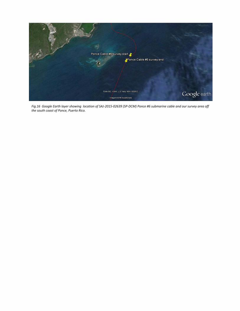
The fifth submarine cable, SAJ201502640 (SPDCM) known as Ponce #5 (PonceSt. Croix), was surveyed but could not be analyzed. The maps provided by Global Marine did not take to account various dredging activities in the Ponce area that, to our knowledge, completely severed the submarine cables prior to the survey start waypoint. We were able to locate segments of the submarine cable east, west and south of Isla Cardona. The team was unable to locate the Ponce #5 submarine cable, as a result of dredging the cable is now located at depths greater than the 250' depth marker. Certain biological aspects could be presumed but cannot be confirmed until our Research Vessel with a remotely operated vehicle (ROV) investigates the submarine cable areas below the 250’ depth marker and locates the submarine cable. The salvage point for this cable will therefore commence at the continental shelf break descent area after it’s located with the Research Vessel and ROV beginning depth at 606’.

The sixth submarine cable, SAJ201502639 (SPDCM) known as Ponce #6 (PonceJamaica), presented two marine habitats: mesophotic coral reef and a continental shelf break. The transect is fairly short considering that a continental shelf break occurs quickly within the survey. The survey commenced with a small mesophotic coral reef before the continental shelf break that possessed very little species richness due to the high concentrations of marine snow and sediment in the water column. Most rocks and corals displayed a layer of sediment at their surface. A colony of wire corals (black coral) were seen in this area. Once we descended at the shelf the concentration of marine snow and sediments increased thus visibility decreased to less than a foot. No species could be identified after the 120’ depth marker. Wire corals (Cirrhipathes leutkeni), were encountered during the survey of this submarine cable at depths between 100’ and 120’ before the continental shelf break descent. The starting salvage point for this submarine cable should not affect the identified species due to removal commencing at the shelf descent at the 601’ depth mark. The submarine cable was not located with video during the survey.