Embed Size (px)
Citation preview
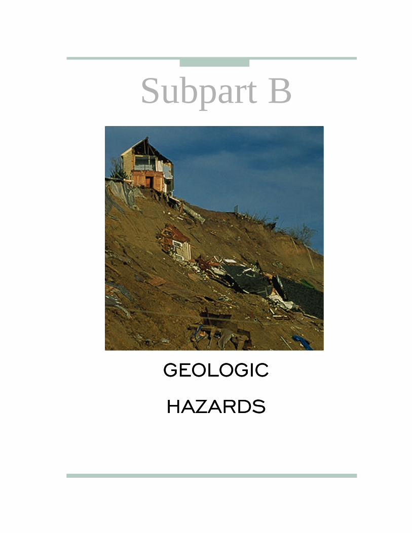
GEOLOGIC
HAZARDS
Subpart B
GEOLOGIC
HAZARDS

NATURAL HAZARDS92 NATURAL HAZARDS
GEOLOGIC HAZARDS
Introduction
GEOLOGIC HAZARDS 93
Introduction
Non-seismic ground failures involving landslides, land subsidence, and expansive soils are significant haz
ards that affect life and property in the United States. These hazards receive limited public attention and funding for hazard assessment and research. However, the combined average annual damage may be comparable to that caused by floods, earth-quakes, and volcanoes.
The occurrence of geologic hazards is often interrelated with other natural phenomena: heavy rainstorms prompted by atmospheric hazards can lead to flooding which can cause debris flows; land subsidence can exacerbate flooding; droughts can provoke shrinking of expansive soils; and ground failures often occur during earthquakes and volcanic activity.
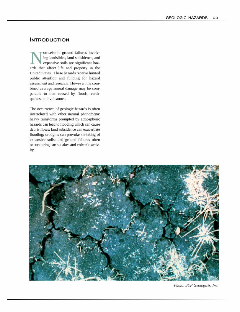
Photo: JCP Geologists, Inc.

CHAPTERCHAPTER
9
LANDSLIDESLANDSLIDES
NATURAL HAZARDS:
Chapter Summary
GEOLOGIC HAZARDS96 NATURAL HAZARDS: GEOLOGIC HAZARDS
Chapter Summary
Several human and natural factors may contribute to or influence landslides. Understanding how these factors interrelate is important in analyzing land-
slide hazards. The principal human factors are mining and construction of highways, buildings, and railroads. The principal natural factors are topography, geology, and precipitation.
Landslides occur in every State and in Guam, Puerto Rico, the U.S. Virgin Islands, and American Samoa. They are most common in the coastal ranges of California, the Colorado Plateau, the Rocky Mountains, and the Appalachian Mountains. During the past 20 years, land-slides have resulted in 38 disaster declarations, 15 of them in California. According to a 1985 study, roughly 40 per-cent of the U.S. population is exposed to direct and indirect effects of landslides.
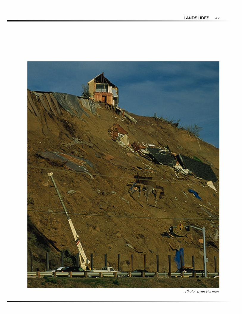
Landslides have damaged or destroyed roads, railroads, pipelines, electrical and telephone lines, mines, oil wells, buildings, canals, sewers, bridges, dams, seaports, airports, forests, parks, and farms. Landslides often are triggered by other natural events such as floods, earthquakes, and volcanic eruptions. The damage caused by landslides
often is attributed to the triggering events. The best estimates of annual losses resulting from landslides in the United States are 25 to 50 lives and $1 to $2 billion in property damage.
Successful mitigation programs have been undertaken at the local level, but the Federal effort is relatively under-funded. Recent efforts involved identification of land-slide-prone areas, anticipating landslide events, and implementation of warning systems. Hazard reduction efforts involve reducing the frequency of landslides, reducing the likelihood that they will cause damage, and minimizing damage.
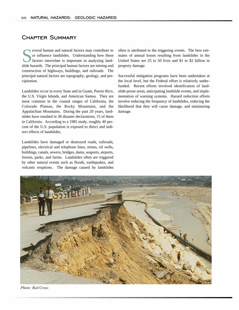
Photo: Red Cross
LANDSLIDESLANDSLIDES 97
Photo: Lynn Forman
NATURAL HAZARDS:
HAZARD IDENTIFICATION
GEOLOGIC HAZARDS98 NATURAL HAZARDS: GEOLOGIC HAZARDS
HAZARD IDENTIFICATION
"Landslide" is used to describe the downward and out-ward movement of slope-forming materials reacting under the force of gravity. The term covers a broad category of events, including mudflows, mudslides, debris flows, rock falls, rock slides, debris avalanches, debris slides, and earth flows. Landslides may consist of natural rock, soil, artificial fill, or combinations of these materials. Earthquakes trigger many landslides, as does heavy and prolonged rains which lead to saturated conditions.
Landslides are classified by type of movement and type of material (Varnes, 1978). The types of movement are slides, flows, lateral spreads, and falls and topples (Varnes, 1978; Pearce and others, 1993; Fleming and Varnes, 1991). The types of material are bedrock and soils, where soils are described as predominately coarse or predominately fine. A combination of two or more of the principle types of flows is referred to as a "complex movement."
• Slides. Slides of soil or rock involve downward displacement along one or more failure surfaces. The material from the slide may be broken into a number of pieces or remain a single, intact mass. Sliding can be rotational, where movement involves turning about a specific point. Sliding can be translational, where movement is downslope on a path roughly parallel to the failure surface. The most common example of a rotational slide is a slump, which has a strong, backward rotational component and a curved, upwardly-concave failure surface.
• Flows. Flows are characterized by shear strains distributed throughout the mass of material. Flows are distinguished from slides by high water content and the distribution of velocities resembles that of viscous fluids. Debris flows are common occurrences in much of North America. These flows are a form of rapid mass movement in which loose soils, rocks, and organic matter, combined with air and water, form a slurry that flows downslope. The term "debris avalanche" describes a variety of very rapid to extremely rapid debris flows associated with volcanic hazards, and is discussed in Chapter 18. The term "avalanche," if unmodified, normally refers to slope movements of snow and ice, and is discussed in Chapter 6. Mudflows are flows of fine-grained mate-rials, such as sand, silt, or clay, with a high water con-tent. A subcategory of debris flows, mudflows contain less than 50 percent gravel.
• Lateral Spreads. Large elements of distributed, lateral displacement of materials characterize lateral spreads. They occur in rock, but the process is not well-documented and the movement rates apparently are very slow. Lateral spreads can occur in fine-grained, sensitive soils such as quick clays, particularly if remolded or disturbed by construction and grading. Loose, granular soils commonly produce lateral spreads through liquefaction. Liquefaction can occur spontaneously, presumably because of changes in pore-water pressures, or in response to vibrations such as those produced by strong earthquakes.
• Falls and Topples. Falls occur when masses of rock or other material detach from a steep slope or cliff and descend by free fall, rolling, or bouncing. Movements are rapid to extremely rapid. Rock falls commonly are triggered by earthquakes. Topples consist of the forward rotation of rocks or other mate-rials about a pivot point on a hillslope. Toppling may culminate in abrupt falling, sliding, or bouncing, but the movement is tilting without collapse. Data on rates of movement and control measures for topples is sparse.
A few nationwide studies of landslides and debris flows have been conducted. The studies attempt to assess areas of the United States where landslides have occurred and areas that are susceptible to landslides.
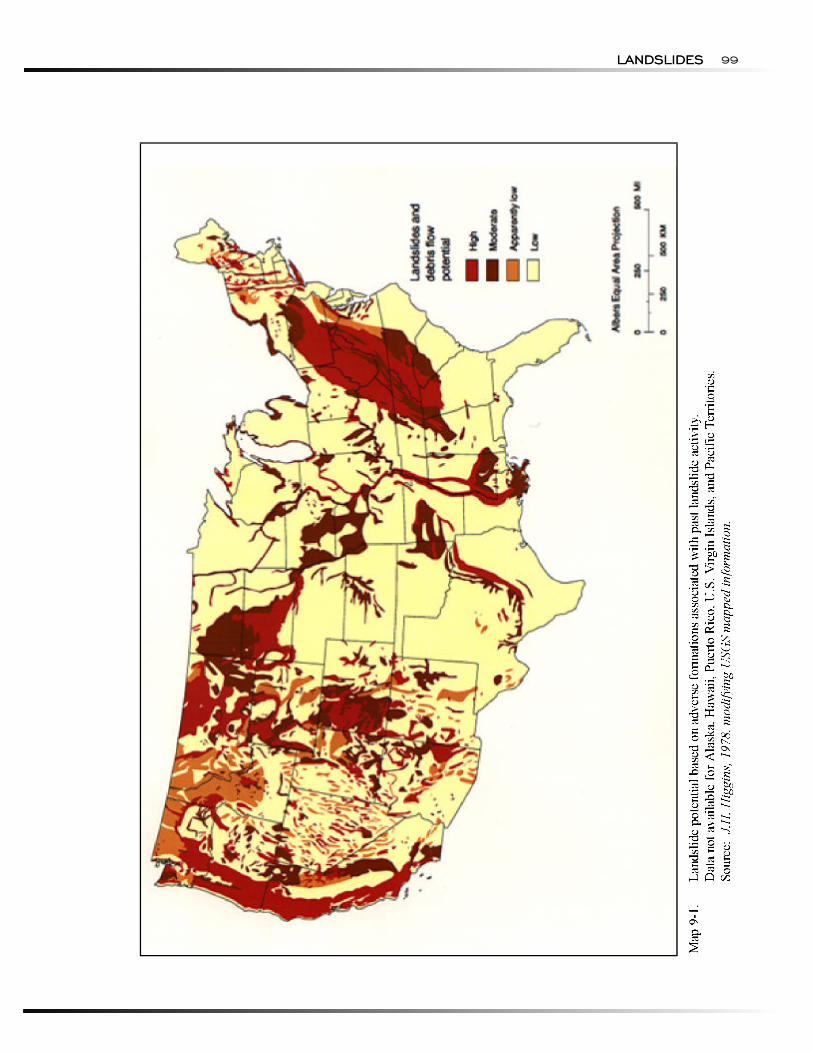
Baker and Chiuruzzi (1958) performed the first regional evaluation of landslides in the United States. They based their evaluation on the results of questionnaires completed by State and Federal agencies, companies, and consultants, and a review of 267 landslide articles and texts published prior to 1950. A list was developed of the most destructive types of landslides, along with estimates of the sediment volume and a small-scale map showing the areas of major, medium, minor, and non-existent landslide intensity.
Radbruch-Hall and others (1976) conducted a survey of the distribution of landslide deposits and materials susceptible to landsliding in the United States. Krohn and Slosson (1976) independently prepared a map of land-slide potential as part of a comprehensive survey of natural hazards.
Wiggins and others (1978) combined topographic, geologic and rainfall information from maps prepared by Baker and Chiuruzzi (1958) and Radbruch-Hall and others (1976). The combination map yielded landslide potential based on adverse formations associated with past landslide activity (Map 9-1).
LANDSLIDESLANDSLIDES 99
NATURAL HAZARDS:
RISK ASSESSMENT
Probability and Frequency
Exposure
GEOLOGIC HAZARDS100 NATURAL HAZARDS: GEOLOGIC HAZARDS
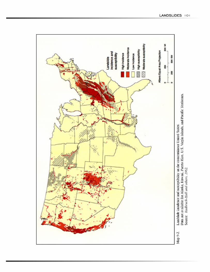
Radbruch-Hall and others (1982) prepared Map 9-2 by evaluating formations and groups of formations shown on a geologic map of the United States (King and Beikman, 1974) and classifying them as having high, moderate, or low landslide incidence (number of land-slides), and high, moderate, or low susceptibility to landsliding. Map units or parts of map units with more than 15 percent of their area involved in landsliding were classified as high incidence. Those with 1.5 to 15 percent of their area involved in landsliding were classified as moderate incidence. Those with less than 1.5 percent of their area involved were classified as low incidence. High, moderate, and low susceptibility were defined by the same percentages. Alluvial fans and earthquake influences were not evaluated.
Several natural and human factors may contribute to or influence landslides. How these factors interrelate is important in analyzing the hazard. The three principal natural factors are topography, geology, and precipitation. The principal human activities are cut-and-fill construction for highways, construction of buildings and railroads, and mining operations.
Topography and geology are related. Topography influences stream erosion and other energy sources that, in turn, influence slope angle and gradient. The steeper a slope, the more gravity plays a role in a landslide. The strength of rocks, measured in terms of their resistance to weathering, is a basic geologic factor in the landslide process. Certain bedrock formations or rock (soil) types appear to be more susceptible than others to land-slide activity.
Precipitation has a pronounced effect on the morphology of the landscape. Slope development is influenced by precipitation that runs off the slope by way of established drainage courses and may have the capacity to erode and undermine slope surfaces. Precipitation that is absorbed increases pore water pressure and lubricates inherently weak zones of rock or soil.
RISK ASSESSMENT
Landslides often are involved in or triggered by other natural hazards. For example, the safety of a dam can be severely compromised by upstream landsliding or collapse of slopes bordering the reservoir or dam abutments. Landsliding and flooding are closely related because both involve precipitation, runoff, and ground saturation. Debris flows usually occur in small, steep stream channels and often are mistaken for floods. Landslides often result from seismic activity as experienced during the 1964 Alaska earthquake, and volcanic activity such as occurred after the 1980 eruption of Mount St. Helens. The simultaneous or sequential
occurrence of interactive hazards may produce cumulative effects that differ significantly from those expected from any one of the components.
Alger and Brabb (1985) listed 6,500 references or sources that either incidentally mentioned or discussed in depth the subject of landslides. Brabb and Harrod's (1989) state-by-state analysis of landslides was the first of its kind, and included a 4-year reconnaissance of all States, the U.S. Virgin Islands, and Puerto Rico, as well as extensive conversations and cooperative programs with geologists and engineers in State geological surveys and State departments of transportation.
Probability and Frequency
Maps 9-1 and 9-2 are combinations of inventory maps showing areas of known landslides, and susceptibility maps showing areas that are likely to experience slope failures. The incidence of, and susceptibility to, landsliding are rated qualitatively as high, moderate, or low. Ratings are assigned on the basis of the number of known landslides and the potential for future landslides. Frequency of occurrence or probability of exceedance are not associated with the information presented.
Jager and Wieczorek (1994) describe a methodology for estimating the spatial probability of a landslide in a given area. This regional model of landslide susceptibility (probability) was developed for the Finger Lakes Region in New York. The occurrence or non-occurrence of landslides based on inventory maps and field inspections in 270-ft (90-m) grid cells (GIS database) was identified throughout the study area. Logistic regression analysis was used to develop a model to predict the susceptibility (probability) of landslides in a given grid cell as a function of soil type, land slope, and historic lake levels. Three levels of susceptibility were defined: low (probability < 0.02); moderate (0.02 < probability < 0.05); and high (probability > 0.05).
The method developed by Jager and Wieczorek (1994) could be used in any area of the United States where adequate landslide inventory maps are available. Note, however, that the probability associated with the susceptibility map is simply the probability of a landslide occurring in a given grid cell and has no implication for repetitive occurrence over time.
Exposure
Landslides occur in every State and in Guam, Puerto Rico, the U.S. Virgin Islands, and American Samoa. They have damaged or destroyed roads, railroads, pipelines, electrical and telephone transmission lines, mining facilities, petroleum wells and production facil-
LANDSLIDESLANDSLIDES 101
Consequences
RESEARCH, DATA COLLECTION, ANDMONITORING ACTIVITIES
NATURAL HAZARDS: GEOLOGIC HAZARDS102 NATURAL HAZARDS: GEOLOGIC HAZARDS
ities, residential and commercial buildings, canals, sewers, bridges, dams, reservoirs, port facilities, airports, forests, fisheries, parks, recreation areas, and farms.
Damage caused directly by landslides is largely undocumented or often is mis-reported. The devastating effects of landslides often are attributed to a triggering principal event, such as a flood, earthquake, volcanic eruption, hurricane, or coastal storm. The magnitude of landslide-related financial losses may exceed all other types of damage commonly attributed to the principal event (Brabb and Harrod, 1989). The best estimates of the direct and indirect costs of landslide damage in the United States is $1 to $2 billion annually. Deaths related to landslides are estimated to be 25 to 50 annually (Schuster and Fleming, 1986; Wold and Jochim, 1989).
Brabb and Harrod (1989) provided an estimate of the number of people per square kilometer who are exposed to the effects of landslides in each State. These estimates were developed by constructing a slope index map of the United States and determining the area of mountainous, hilly, and steep valley terrain, where landslides are likely to occur. The 1985 population by State was superimposed on the mountainous, hilly, and steep valley areas to determine the number of people per square kilometer. This analysis indicated approximately 108 million people, or more than 40 percent of the 1985 population, were exposed to direct and indirect effects of landslides in the United States and its territories.
Consequences
Public and private economic losses from landslides include not only the direct costs of replacing and repairing damaged facilities, but also the indirect costs associated with lost productivity, disruption of utility and transportation systems, and reduced property values. Some indirect costs of landslides are difficult to evaluate, thus estimates are conservative or ignored. If indirect costs were rigorously determined, they likely would exceed direct costs (Schuster and Fleming, 1986).
Much of the economic loss is borne by Federal, State, and local agencies responsible for disaster assistance, flood insurance, and highway maintenance and repair. Private costs involve mainly damage to land and structures. A severe landslide can result in financial ruin for affected property owners because landslide insurance (except for debris flow coverage) or other means of spreading the costs of damage are unavailable.
The most financially devastating slope failures in the United States were associated with the Alaska earth-
quake of 1964, the 1980 landslides in southern California, the eruption of Mount St. Helens in Washington, the 1982 landslides in the San Francisco Bay area, and the 1983-84 landslides in Utah. Combined, these events caused estimated damages in excess of $2 billion.
Ground failure caused approximately 60 percent of the $311 million total damage from the 1964 Alaska earth-quake (Youd, 1978). About one-third of the cost of the $1.5 billion 1980 eruption of Mount St. Helens can be attributed to landslides (Schuster, 1983). That same year, total losses in six southern California counties resulting from landslides triggered by high-intensity rainfall approximated $500 million (Slosson and Krohn, 1982).
The intense storms of early January 1982 in the San Francisco Bay region triggered thousands of debris flows, resulting in 25 deaths and $66 million in property damage. Following the San Francisco catastrophe, 930 lawsuits and claims totaling nearly $300 million were filed against city and county agencies in the region, an amount several times greater than the total property losses (Smith, 1982).
Total direct costs of landslides in Utah in the spring of 1983 were estimated at $250 million (Anderson and others, 1984), while estimates of the 1984 events were as high as $50 million (Schuster and Fleming, 1986).
During the past 20 years, landslides have resulted in 38 disaster declarations—15 of them in California, and the rest scattered among 15 other States. While many States have adopted programs to investigate and resolve problems related to landslides, the total effort is relatively minor.
RESEARCH, DATA COLLECTION, AND MONITORING ACTIVITIES
The level of effort directed to landslide research and hazard assessment is small compared to some other hazards. At the Federal level, Brabb and Harrod (1989) concluded that the USGS devoted no more than 20 per-son-years each year to landslide research. According to Sangrey and others (1985), USGS spent the bulk (about one-fourth) of the $10 million allocated for landslide research by all Federal agencies.
Information about landslide work conducted by other Federal agencies is sparse. However, FEMA, the Federal Highway Administration, U.S. Bureau of Reclamation, U.S. Forest Service, and the National Science Foundation have all contributed.
MITIGATION APPROACHES
RECOMMENDATIONS
LANDSLIDESLANDSLIDES 103
In response to the severe rainstorm in January 1982 that triggered more than 18,000 debris flows and other land-slides in the San Francisco Bay area, USGS and NWS developed and currently operate a system for warning the public when conditions reach levels sufficient to trigger debris flows. During the rainy season (October through April), USGS monitors more than 50 radiotelemetered rain gauges in the network coordinated by NWS.
The rainfall data and measurements of soil moisture at a study site in the hills south of San Francisco are used to estimate moisture level of soils throughout the Bay area. Once the soils have reached a sufficient moisture level, USGS monitors NWS forecasts and uses real-time rainfall data from the gauge network to determine the potential for imminent debris flows.
USGS developed thresholds that describe the minimum rainfall rates that may trigger abundant debris flows on natural slopes in the San Francisco Bay region. NWS broadcasts warnings over weather radio and as an emergency broadcast system announcement over many radio and television stations.
MITIGATION APPROACHES
Successful and cost-effective landslide mitigation pro-grams can be implemented. Such programs exist in other countries, including Japan. Although there have been some impressive and successful local demonstrations of landslide control programs, information has not been widely disseminated. This is characteristic of the scattered and diffused state of landslide knowledge in the United States. As noted by NRC (1985), there is no recognized national leadership or systematic basis for communication.
Landslides stand out as a severe hazard, yet mitigation efforts are relatively underfunded. Practical application of land-use zoning measures, based on appropriate research and enforced by local regulations, can lead to dramatic loss reductions. This has been demonstrated in the Los Angeles area, where 92-97 percent reductions in losses were achieved for new construction (Slosson and Krohn, 1982).
There are two distinct components to reducing the cost associated with landsliding: emergency management and response, and long-term hazard reduction (NRC, 1985). Emergency management includes: anticipation, prediction, and issuance of warnings of the impending occurrence of life- and property-threatening landslides; response that is required when landslides occur; identification of landslide-prone areas; and planning, train
ing, and other preparatory measures necessary to ensure effective warning and response.
Long-term hazard reduction focuses on reducing the frequency of landslides, reducing the likelihood that landslides will cause damage, and minimizing damage when landslides do occur. Landslide losses can be reduced in two ways: reduce the occurrence by requiring that excavation, grading, landscaping, and construction be carried out in ways that do not contribute to slope instability; and minimize the damage when land-slides do occur by restricting development in landslide-prone terrain and by protecting buildings and other structures from landslide damage (NRC, 1985). Wold and Jochim (1989) provide additional details for reducing long-term losses.
Although NRC (1985) identifies insurance as a long-term hazard-reduction measure, Wold and Jochim (1989) note that insurance does not reduce losses, but provides financial protection to individual owners, Although insurance for landslides is not available, dam-age from debris flows (mudflows) is covered under the NFIP. Campbell and others (1985) describe flows and slides that are and are not covered under the NFIP.
Kockelman (1986) discusses additional techniques for reducing landslide losses:
• Through land-use planning, discourage new developments in identified hazard areas by informing and educating the public and posting warnings of potential hazards;
• Remove or convert existing development through acquiring, exchanging, or removing susceptible properties and discontinuing non-conforming uses; and
• Provide financial incentives or disincentives by adopting lending policies that reflect risk of loss or conditioning Federal and State financial assistance.
RECOMMENDATIONS
Several programs have been proposed to reduce the cost of landslide-related damage in the United States. The NRC Committee on Ground Failure Hazards (1985) recommended: more effective land-use regulation; building codes; research on landslide initiation and processes, landslide hazard delineation, mapping, and control; technology transfer; landslide insurance (exclusive of debris flows, for which insurance already exists); national leadership; and legislation to direct a governmental or private program to reduce landslide losses.
BIBLIOGRAPHY AND REFERENCES
NATURAL HAZARDS: GEOLOGIC HAZARDS104 NATURAL HAZARDS: GEOLOGIC HAZARDS
The USGS proposed elements of a landslide loss-reduction program. At FEMA's request, USGS prepared a feasibility study for a nationwide landslide mapping effort (Campbell, 1985).
BIBLIOGRAPHY AND REFERENCES
Alger, C.S., and E.E. Brabb. 1985. Bibliography of United States Landslide Maps and Reports. U.S. Geological Survey Open-File Report 85-585.
Anderson, L.R., J.R. Keaton, T. Saarinen, and W.G. Wells, II. 1984. The Utah Landslides, Debris Flows, and Floods of May-June 1983. National Research Council. Washington, DC: National Academy Press.
Baker, R.F., and R. Chiuruzzi. 1958. "Regional Concept of Landslide Occurrence." Highway Research Board Bulletin. No. 216, pp. 1-17.
Brabb, E.E., and B.L. Harrod. (Eds) 1989. Landslides: Extent and Economic Significance. Proceedings of the 28th International Geological Congress: Symposium on Landslides. Washington, DC, Rotterdam: Balkema.
Campbell, R.H. (Ed.). 1985. Feasibility of a Nationwide Program for the Identification and Delineation of Hazards from Mud Flows and Other Landslides. U.S. Geological Survey Open-File Report 85-276A.
Fleming, R.W., and J.D. Varnes. 1991. "Slope Movements," Chapter 9 in The Heritage of Engineering Geology: The First Hundred Years, Kiersch, G.A. (Ed.) Centennial Special Volume 3. Boulder, CO: Geological Society of America.
Fleming, R.W., and F.A. Taylor. 1980. Estimating the Costs of Landslide Damage in the United States. U.S. Geological Survey Circular 832.
Harp, E.L., and R.W. Jibson. 1995. Inventory of Landslides Triggered by the 1994 Northridge, California, Earthquake. U.S. Geological Survey Open-File Report 95-213.
Jager, S., and G.F. Wieczorek. 1994. Landslide Susceptibility in the Tully Valley Area, Finger Lakes Region, New York. U.S. Geological Survey Open-File Report 94-615.
King, P.B., and H.M. Beikman. 1974. Geologic Map of the United States (exclusive of Alaska and Hawaii). Scale 1:2,500,000. U.S. Geological Survey.
Kockelman, W.J. 1986. "Some Techniques for Reducing Landslide Hazards." Association of Engineering Geologists Bulletin. Vol. 33, No. 1, pp. 29-52.
Krohn, J.P., and J.E. Slosson. 1976. "Landslide Potential in the United States." California Geology. Vol. 29, No. 10, pp. 224-231.
National Research Council. 1985. Reducing Losses from Landsliding in the United States. Washington, DC: National Academy Press.
Pearce, L., H. Hightower, B. Konkin, S. Megalos, and J. Pernu. 1993. British Columbia: Hazard, Risk and Vulnerability Analysis. Vol. 1. The Disaster Preparedness Resources Center, The University of British Columbia.
Radbruch-Hall, D.H., R.B. Colton, W.E. Davies, I. Lucchita, B.A. Skipp, and D.J. Varnes. 1982. Landslide Overview Map of the Conterminous United States. Scale 1:7,500,000. U.S. Geological Survey Professional Paper 1183.
Radbruch-Hall, D.H., R.B. Colton, W.E. Davies, B.A. Skipp, I. Lucchita, and D.J. Varnes. 1976. Preliminary Landslide Overview Map of the Conterminous United States. Scale 1:7,500,000. U.S. Geological Survey Miscellaneous Field Studies Map MF-771.
Sangrey, D.A., and others. 1985. U.S. Geological Survey Landslide Research Program's Report of the Committee for Review of the U.S. Geological Survey Ground Failure and Construction Hazards Program. U.S. Geological Survey Administrative Report.
Schuster, R.L., and R.W. Fleming. 1986. "Economic Losses and Fatalities Due to Landslides." Association of Engineering Geologists Bulletin. Vol. 23, No.1, pp. 11-28.
Slosson, J.E., and J.P. Krohn. 1982. "Southern California Landslides of 1978 and 1980." Storms, Floods and Debris Flows in Southern California and Arizona, 1978 and 1980: Proceedings of a Symposium. Washington, DC: National Academy Press.
Smith, T.C. 1982. "Lawsuits and Claims Against Cities and Counties Mount After January 1982 Storm." California Geology. Vol. 35, No. 7, pp.163-164.
LANDSLIDESLANDSLIDES 105
Toppozada, T., G. Borchardt, W. Haydon, M. Peterson, R. Olson, H. Lagorio, and T. Anvik. January 1995. Planning Scenario in Humboldt and Del Norte Counties, California, for a Great Earthquake on the Cascadia Subduction Zone. California Department of Conservation, Division of Mines and Geology, Special Publication 115.
Varnes, D.J.. 1978. "Slope Movement Types and Processes," in Landslides: Analysis and Control, Schuster, R.L., and R.J. Krizek (ed.). National Academy of Sciences, National Research Council, Transportation Research Board. Special Report No. 176, pp. 11-33.
Wiggins, J.H., J.E. Slosson, and J.P. Krohn. 1978. Natural Hazards: Earthquake, Landslide, Expansive Soil Loss Models. Institute of Behavioral Science. The University of Colorado, Boulder, CO.
Wold, R.L. Jr., and C.L. Jochim. 1989. Landslide Loss Reduction: A Guide for State and Local Government Planning. Denver, CO: Colorado Geological Survey, Department of Natural Resources.
Youd, T.L. 1978. "Major Cause of Earthquake Damage is Ground Failure." Civil Engineering. American Society of Civil Engineers. Vol. 48, No. 4, pp. 47-51.

CHAPTERCHAPTER
10
LANDLAND SUBSIDENCESUBSIDENCE

NATURAL HAZARDS:
Chapter Summary
GEOLOGIC HAZARDS108 NATURAL HAZARDS: GEOLOGIC HAZARDS
Chapter Summary
Land subsidence, the loss of surface elevation due to the removal of subsurface support, ranges from broad, regional lowering of the land surface to
localized collapse. The primary causes of most subsidence are human activities: underground mining of coal, ground-water or petroleum withdrawal, and drainage of organic soils. This hazard affects parts of at least 45 States. However, because of the broad range of causes and impacts, there has been limited national focus on this hazard.
Regional lowering of land elevation occurs gradually over time. It may aggravate flooding potential, particularly in coastal areas. Collapses, such as the sudden formation of sinkholes or the collapse of an abandoned mine, may destroy buildings, roads, and utilities.
Generally, subsidence poses a greater risk to property than to life. The average annual damage from all types of subsidence is conservatively estimated to be at least $125 mil-lion. Damage consists primarily of direct structural dam-age and property loss and depreciation of land values, but also includes business and personal losses that accrue during periods of repair.
Current efforts to address subsidence include improved hazard identification, public information programs, map-ping, regulation of subsurface resources and land development, land-use management and building codes, and insurance. Mitigation measures generally are designed for specific situations.
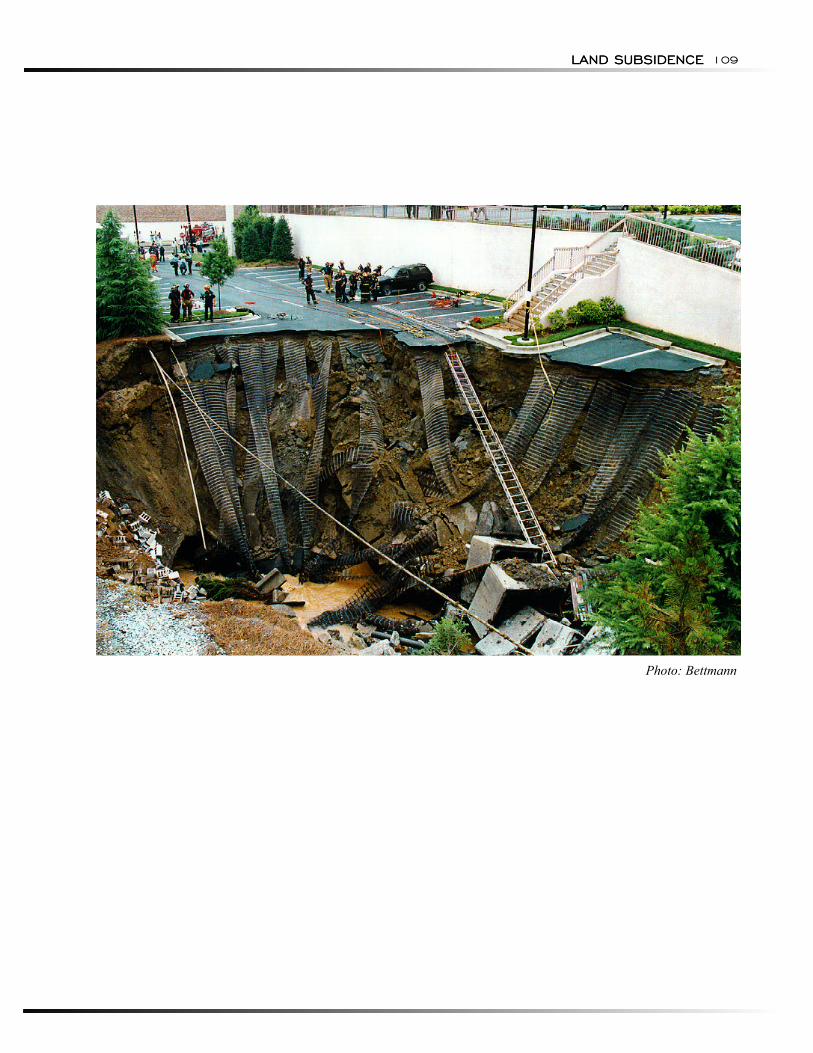
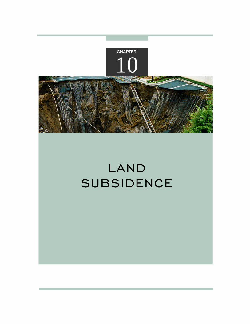
LAND SUBSIDENCELAND SUBSIDENCE 109
Photo: Bettmann
NATURAL HAZARDS:
HAZARD IDENTIFICATION
Collapse Into Voids.
Sediment Compaction.
GEOLOGIC HAZARDS110 NATURAL HAZARDS: GEOLOGIC HAZARDS
HAZARD IDENTIFICATION
Land subsidence affects parts of at least 45 States. More than 17,000 mi2 (44,000 km2) of land has been lowered. Resource development and land-use practices, particularly underground mining of coal, groundwater and petroleum withdrawal, and drainage of organic soils, are the primary causes (NRC, 1991). Land subsidence due to surface faulting and liquefaction, triggered by earthquakes, is discussed in Chapter 16.
Subsidence is caused by a diverse set of human activities and natural processes that include mining of coal, metallic ores, limestone, salt, and sulfur; withdrawal of groundwater, petroleum, and geothermal fluids; dewatering of organic soils; wetting of dry, low-density deposits known as hydrocompaction; natural sediment compaction; melting of permafrost; liquefaction; and crustal deformation. This diversity and the broad range of impacts probably influence lack of a national focus on subsidence. Instead, many industries, professions, and Federal, State, and local agencies are involved independently.
Collapse Into Voids. Collapse of surficial materials into underground voids is the most dramatic form of subsidence. Most of the subsidence-related voids in the United States were created by coal mining. Coal-mine subsidence is caused by collapse of the mined-out or tunneled voids, and depends on the number, type, and extent of the voids. Abandoned tunnels and under-ground mining of metallic ores, limestone, and salt con-tribute to a much smaller extent, although problems may be severe at specific locations. For example, hundreds of subsidence occurrences in the Midwest have been associated with failures of abandoned lead-zinc mines.
In the longwall method of mining coal, in which most of the coal seam is removed along a single face, the roof above the mined-out seam is allowed to collapse as the mining progresses. Subsidence above longwall mines is rapid, generally ending within a few months after removal of subsurface supports.
Subsidence associated with partial extraction mining is usually unplanned. In this method, only a portion of the coal called the "rooms" is removed; the unmined portions, the "pillars," are left to provide support. Subsidence resulting from collapse into rooms may take years to manifest. Examples of collapses occurring 100 years after mines were abandoned have been documented (NRC, 1991).
Although most collapses are human-induced, some cavities in bedrock were formed prior to human activities. This is particularly true of carbonates such as limestone, because rates of solution are so low. Cavities in halite can be an exception because of its high solubility. For example, in the last 30 years several dozen sinkholes have formed in Kansas as a result of dissolution of salt beds by leaks through casings of brine-disposal wells. A recent example is a 200-ft (60-m) wide, 110-ft (33-m) deep sinkhole that formed during the summer of 1988 near Macksville, KS (Geotimes, 1988). Catastrophic subsidence is most commonly induced by water-table lowering, rapid water-table fluctuation, diversion of surface water, construction, use of explosives, or impoundment of water.
Sediment Compaction. Sediment compaction typically causes broad regional subsidence. Exceptions include ground rupture and hydrocompaction. Rates of subsidence usually are low, ranging from a few millimeters to centimeters per year, but total subsidence may reach several meters over decades. Sediment compaction results from underground fluid withdrawal, natural compaction, and hydrocompaction.
Underground fluid withdrawal is one of the major causes of sediment compaction in the United States. The weight of the overburden above fluid reservoirs is sup-ported by both the fluid pressures and stresses transmitted through the solid skeleton of the reservoir soil or rock. When fluids are withdrawn, fluid pressures decline and support of the overburden is transferred to the solid skeleton. If the reservoir soil or rock is compressible, sediment compaction and subsidence occur.
Another type of sediment compaction occurs naturally as older sediment is buried by younger sediment. Natural subsidence is occurring most rapidly in the Mississippi River Delta area of southern Louisiana, where approximately 1,500 mi2 (3,900 km2) of land are subsiding. Estimated average rates of subsidence range from 0.3 to 0.4 in (0.8 to 1.0 cm) per century (Penland and others, 1988). Maximum rates measured by geodetic surveys are approximately 0.5 in (1.3 cm) per year.
Hydrocompaction occurs when dry, low-density sediments collapse because moisture content increases. These sediments, known as collapsible soils, generally are of two types: mudflow deposits in alluvial fans, and wind-deposited, moisture-deficient silt called loess. Most collapsible soils have low densities because they remained moisture deficient throughout their post-depositional history. When water percolates through the root zone into these soils, the structure collapses, the soil compacts, and very localized subsidence may result.
LAND SUBSIDENCE
Drainage of Organic Soils.
RISK ASSESSMENT
Probability and Frequency
Exposure
Collapse Into Voids.
Sediment Compaction.
LAND SUBSIDENCE 111
Drainage of Organic Soils. Drainage of organic soils, particularly peat and muck, induces a series of processes that reduces the volume of soil. These processes include biological oxidation, compaction, and desiccation. Biological oxidation usually dominates in warm climates. The principal areas of organic soil subsidence in the United States are the greater New Orleans, LA area; the Sacramento-San Joaquin River Delta, CA; and parts of the Florida Everglades. Maximum observed subsidence is 21.0 ft (6.4 m) in the Sacramento-San Joaquin River Delta (Ireland and others, 1984).
RISK ASSESSMENT
The National Research Council compiled maps showing the cumulative damage by State resulting from various types of land subsidence (NRC, 1991). These maps, which appear in the subsection on Consequences, can be used as a measure of the risk associated with land subsidence. The time periods for compilation of the cumulative costs vary from state-to-state, and the costs were not converted to constant dollars. In general, the costs indicated are considered to be conservative estimates.
Probability and Frequency
Land subsidence occurs slowly and continuously over time or on abrupt occasions, as in the case of sudden formation of sinkholes. Procedures for determining the probability or frequency of land subsidence have not been recommended. The cumulative damage land subsidence maps discussed later in this chapter do not imply probability or frequency of occurrence.
Exposure
Exposure of people and property is a function of the type and duration of subsidence, and extent of the area affected.
Collapse Into Voids. Collapse of surficial materials into underground voids is most commonly associated with coal mining. Coal is found in 37 States and mined underground in 22 States (HRB-Singer, 1980). Approximately 12,400 mi2 (32,000 km2) of land is undermined, and it is anticipated that the area will ultimately increase to 62,500 mi2 (162,000 km2). Approximately 3,100 mi2 (8,000 km2) of the under-mined area, most of which is in the Eastern United States, already has experienced subsidence.
The U.S. Bureau of Mines estimates that 620 mi2 (1,600 km2) of land in urban areas is threatened (Johnson and Miller, 1979). Seventy-one percent of this area is in Pennsylvania, Illinois, and West Virginia.
Davies and others (1976) indicate more than 500,000 mi2 (1.4 million km2 ) of land in 39 States is underlain by cavernous limestone and marble. More than 11,600 mi2 (30,000 km2) of this area lies beneath Standard Metropolitan Statistical Areas inhabited by 33 million people (HRB-Singer, 1977). However, only a small portion is actually underlain by voids and considered to be at-risk of subsidence.
The States with the greatest number of active sinkholes are Alabama, Florida, Georgia, Indiana, Missouri, Pennsylvania, and Tennessee. Newton (1986) estimates that more than 6,000 collapses have occurred in the Eastern United States since around 1950.
Sediment Compaction. Sediment compaction subsidence is caused by pumping groundwater and petroleum. More than 30 areas in seven States have experienced land subsidence of this type. The two largest areas are in the San Joaquin Valley, CA, and Houston, TX, where approximately 5,200 mi2 and 4,800 mi2
(13,500 km2 and 12,500 km2), respectively, have sub-sided because of groundwater withdrawal. Maximum elevation loss from this type of subsidence has been 30 ft (9 m) in the San Joaquin Valley from the mid-1920s to 1977 (Ireland and others, 1984). Petroleum withdrawal in Long Beach, CA, caused parts of the City's harbor facility to subside almost 29.6 ft (9 m) from 1937 to 1966.
Groundwater withdrawal in Houston, TX, caused some coastal areas to subside more than 6 ft (2 m). Approximately 30 mi2 (80 km2) of land were inundated. Several hundred square kilometers, including the 500-unit Brownwood Subdivision in Baytown which was abandoned in 1983, were added to areas susceptible to flooding by storm surges. Some areas of local subsidence in the Houston area resulted from the extraction of gas and oil.
Damaging hydrocompaction has been reported in 17 States. The three largest affected areas are the alluvial slopes of the western San Joaquin Valley and loess-covered areas in the Missouri River basin and the Pacific Northwest. Other known areas of hydrocompaction include the Heart Mountain-Chapman Beach and Riverton areas in Wyoming; Hysham Bench, MT; Denver, CO; and the Washington-Hurricane-Cedar City areas in southwest and central Utah. The major impact has been on design and operation of hydraulic structures such as canals, aqueducts, and dams. Locally sig-
NATURAL HAZARDS:
Drainage of Organic Soils.
Consequences
GEOLOGIC HAZARDS112 NATURAL HAZARDS: GEOLOGIC HAZARDS
nificant impacts have been sustained by buildings and highways. Irrigation for agriculture has caused differential hydrocompaction that required re-leveling of fields.
Drainage of Organic Soils. Approximately 3,600 mi2 (9,400 km2) of land underlain by organic soil has subsided because of drainage of organic soils. An even larger area is susceptible to subsidence. Approximately 39,000 mi2 (101,000 km2) of the conterminous United States are covered by peat and muck soils (Stephens and others, 1984) and more than 10,000 mi2 (26,000 km2) of organic wetlands are in Standard Metropolitan Statistical Areas (HRB-Singer, 1977).
Consequences
The average annual damage from all types of subsidence is estimated conservatively to be at least $125 million. The estimated annual damage by type of subsidence is given in Table 10-1 (NRC, 1991). The practical impacts of land subsidence depend on the specific form of surface deformation. Regional lowering may either aggravate the flood potential or permanently inundate an area, particularly in coastal or riverine settings. Local collapse may impair or destroy buildings, roads, and utilities.
The major damage results from underground mining of coal, withdrawal of underground water and petroleum, and drainage of organic soils. The costs consist primarily of direct structural and property losses and depreciation of land values, but also include business and personal losses incurred during periods of repair. Subsidence is more hazardous to property than to life, because of the typically low rates of surface lowering, and has caused few casualties. However, subsidence increases the potential for loss of life in flood-prone areas by increasing the depth of floodwaters and extent of areas susceptible to flooding.
Although total annual damage associated with subsidence is small relative to the U.S. economy, subsidence imposes substantial costs on individual cities and neighborhoods. Cities where cumulative damage from subsidence exceed $100 million include Long Beach, CA; Houston, TX; and New Orleans, LA.
Collapse Into Voids. Most mine-related subsidence damage in the United States is associated with abandoned coal mines over which urban growth has occurred. Damage in urban areas has been estimated to cost more than $30 million annually (HRB-Singer, 1977). In Scranton, PA, and Seattle, WA, collapse of abandoned coal mines has damaged surface structures. In rural areas subsidence affects field drainage, reduces crop yields, and lowers property values. A study in Illinois indicated property values in rural areas affected by subsidence were discounted an average of 16 percent (Illinois Department of Energy and Natural Resources, 1985).
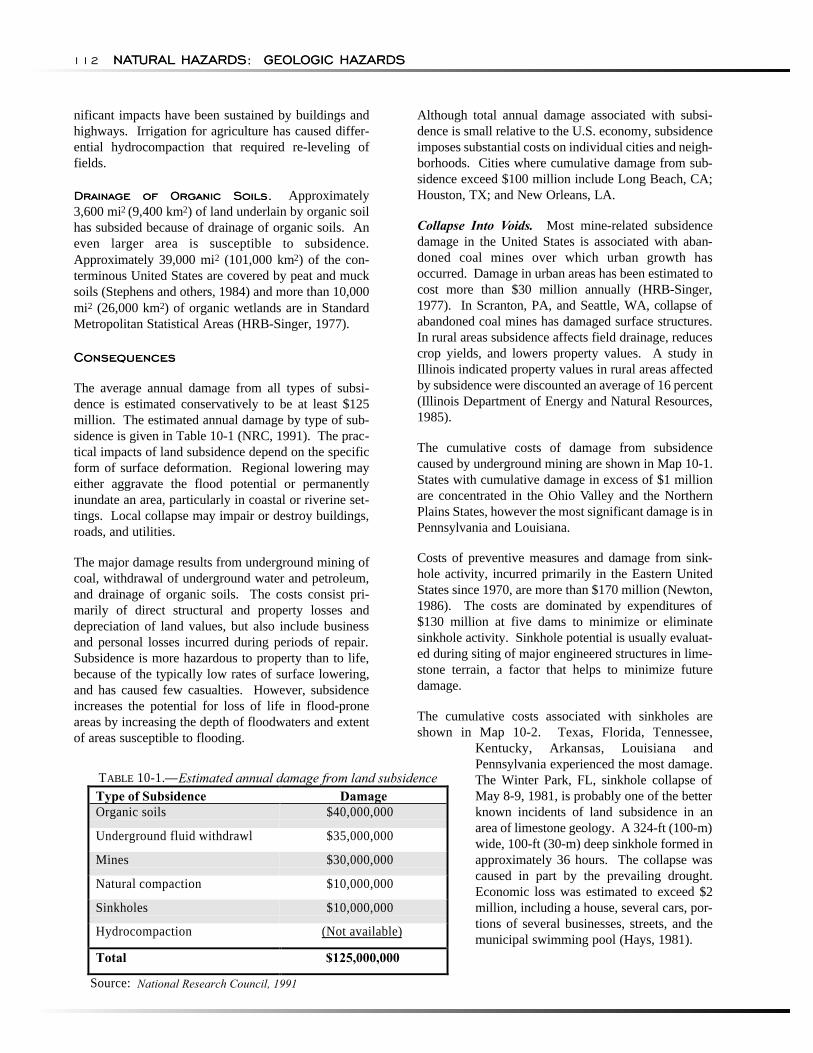
The cumulative costs of damage from subsidence caused by underground mining are shown in Map 10-1. States with cumulative damage in excess of $1 million are concentrated in the Ohio Valley and the Northern Plains States, however the most significant damage is in Pennsylvania and Louisiana.
Costs of preventive measures and damage from sink-hole activity, incurred primarily in the Eastern United States since 1970, are more than $170 million (Newton, 1986). The costs are dominated by expenditures of $130 million at five dams to minimize or eliminate sinkhole activity. Sinkhole potential is usually evaluated during siting of major engineered structures in lime-stone terrain, a factor that helps to minimize future damage.
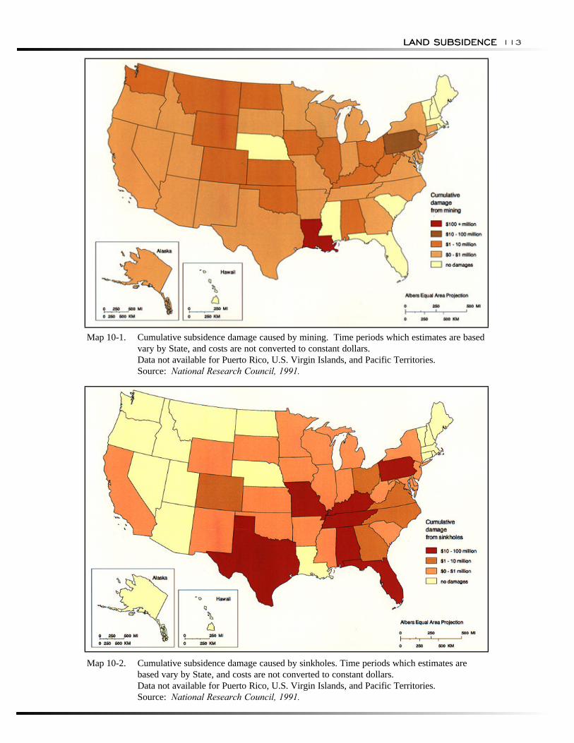
The cumulative costs associated with sinkholes are shown in Map 10-2. Texas, Florida, Tennessee,
Kentucky, Arkansas, Louisiana and Pennsylvania experienced the most damage.
TABLE 10-1.—Estimated annual damage from land subsidence The Winter Park, FL, sinkhole collapse of May 8-9, 1981, is probably one of the better known incidents of land subsidence in an area of limestone geology. A 324-ft (100-m) wide, 100-ft (30-m) deep sinkhole formed in approximately 36 hours. The collapse was caused in part by the prevailing drought. Economic loss was estimated to exceed $2 million, including a house, several cars, portions of several businesses, streets, and the municipal swimming pool (Hays, 1981).
Source: National Research Council, 1991
Type of Subsidence Damage Organic soils $40,000,000
Underground fluid withdrawl $35,000,000
Mines $30,000,000
Natural compaction $10,000,000
Sinkholes $10,000,000
Hydrocompaction (Not available)
Total $125,000,000
LAND SUBSIDENCELAND SUBSIDENCE 113
Map 10-1. Cumulative subsidence damage caused by mining. Time periods which estimates are based vary by State, and costs are not converted to constant dollars. Data not available for Puerto Rico, U.S. Virgin Islands, and Pacific Territories. Source: National Research Council, 1991.
Map 10-2. Cumulative subsidence damage caused by sinkholes. Time periods which estimates are based vary by State, and costs are not converted to constant dollars. Data not available for Puerto Rico, U.S. Virgin Islands, and Pacific Territories. Source: National Research Council, 1991.
Sediment Compaction.
Drainage of Organic Soils.
RESEARCH, DATA COLLECTION, ANDMONITORING ACTIVITIES
NATURAL HAZARDS: GEOLOGIC HAZARDS114 NATURAL HAZARDS: GEOLOGIC HAZARDS
Sediment Compaction. Damage from compaction caused by withdrawal of underground fluids is dominated by large losses in a few areas. For example, although subsidence caused by petroleum withdrawal in Long Beach, CA, is under control, mitigation activities cost approximately $150 million from 1937 to 1966 (Mayuga, 1970).
Jones (1977) estimated that damage in the Houston area averaged $31.7 million annually from 1969 to 1974. Costs were nearly equally divided between decreased property values and actual damage, and most were associated with increased flood risk and permanent inundation. Prokopovich and Marriott (1983) estimated that post-construction rehabilitation of subsidence damage to California's Central Valley Project canals cost $34 million.
The only available estimate of subsidence damage to well fields was prepared by Roll (1967) for Santa Clara Valley, CA, where more than $4 million was spent to repair or replace well casings.
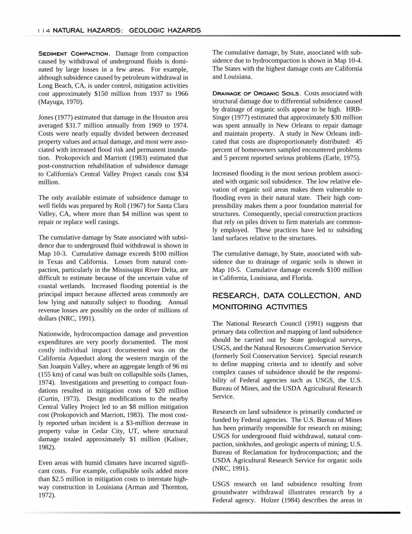
The cumulative damage by State associated with subsidence due to underground fluid withdrawal is shown in Map 10-3. Cumulative damage exceeds $100 million in Texas and California. Losses from natural compaction, particularly in the Mississippi River Delta, are difficult to estimate because of the uncertain value of coastal wetlands. Increased flooding potential is the principal impact because affected areas commonly are low lying and naturally subject to flooding. Annual revenue losses are possibly on the order of millions of dollars (NRC, 1991).
Nationwide, hydrocompaction damage and prevention expenditures are very poorly documented. The most costly individual impact documented was on the California Aqueduct along the western margin of the San Joaquin Valley, where an aggregate length of 96 mi (155 km) of canal was built on collapsible soils (James, 1974). Investigations and presetting to compact foundations resulted in mitigation costs of $20 million (Curtin, 1973). Design modifications to the nearby Central Valley Project led to an $8 million mitigation cost (Prokopovich and Marriott, 1983). The most costly reported urban incident is a $3-million decrease in property value in Cedar City, UT, where structural damage totaled approximately $1 million (Kaliser, 1982).
Even areas with humid climates have incurred significant costs. For example, collapsible soils added more than $2.5 million in mitigation costs to interstate high-way construction in Louisiana (Arman and Thornton, 1972).
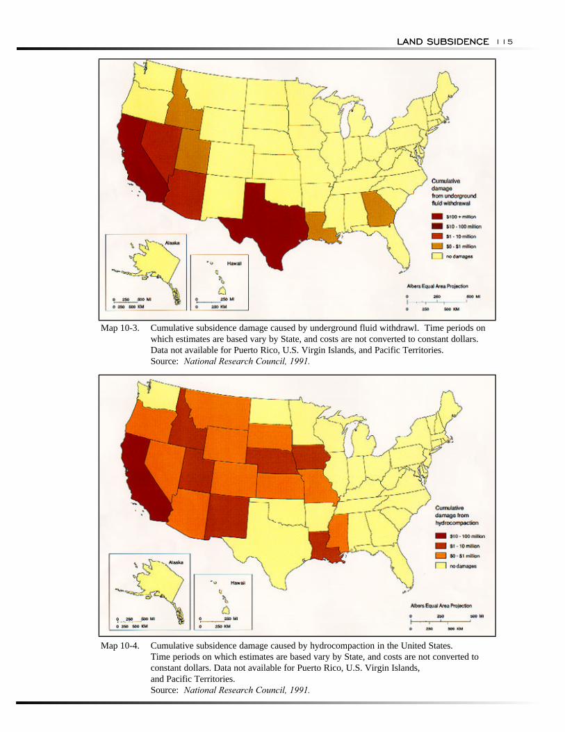
The cumulative damage, by State, associated with subsidence due to hydrocompaction is shown in Map 10-4. The States with the highest damage costs are California and Louisiana.
Drainage of Organic Soils. Costs associated with structural damage due to differential subsidence caused by drainage of organic soils appear to be high. HRB-Singer (1977) estimated that approximately $30 million was spent annually in New Orleans to repair damage and maintain property. A study in New Orleans indicated that costs are disproportionately distributed: 45 percent of homeowners sampled encountered problems and 5 percent reported serious problems (Earle, 1975).
Increased flooding is the most serious problem associated with organic soil subsidence. The low relative elevation of organic soil areas makes them vulnerable to flooding even in their natural state. Their high compressibility makes them a poor foundation material for structures. Consequently, special construction practices that rely on piles driven to firm materials are commonly employed. These practices have led to subsiding land surfaces relative to the structures.
The cumulative damage, by State, associated with subsidence due to drainage of organic soils is shown in Map 10-5. Cumulative damage exceeds $100 million in California, Louisiana, and Florida.
RESEARCH, DATA COLLECTION, AND MONITORING ACTIVITIES
The National Research Council (1991) suggests that primary data collection and mapping of land subsidence should be carried out by State geological surveys, USGS, and the Natural Resources Conservation Service (formerly Soil Conservation Service). Special research to define mapping criteria and to identify and solve complex causes of subsidence should be the responsibility of Federal agencies such as USGS, the U.S. Bureau of Mines, and the USDA Agricultural Research Service.
Research on land subsidence is primarily conducted or funded by Federal agencies. The U.S. Bureau of Mines has been primarily responsible for research on mining; USGS for underground fluid withdrawal, natural compaction, sinkholes, and geologic aspects of mining; U.S. Bureau of Reclamation for hydrocompaction; and the USDA Agricultural Research Service for organic soils (NRC, 1991).
USGS research on land subsidence resulting from groundwater withdrawal illustrates research by a Federal agency. Holzer (1984) describes the areas in
LAND SUBSIDENCELAND SUBSIDENCE 115
Map 10-3. Cumulative subsidence damage caused by underground fluid withdrawl. Time periods on which estimates are based vary by State, and costs are not converted to constant dollars. Data not available for Puerto Rico, U.S. Virgin Islands, and Pacific Territories. Source: National Research Council, 1991.
Map 10-4. Cumulative subsidence damage caused by hydrocompaction in the United States. Time periods on which estimates are based vary by State, and costs are not converted to constant dollars. Data not available for Puerto Rico, U.S. Virgin Islands, and Pacific Territories. Source: National Research Council, 1991.
MITIGATION APPROACHES
NATURAL HAZARDS: GEOLOGIC HAZARDS116 NATURAL HAZARDS: GEOLOGIC HAZARDS
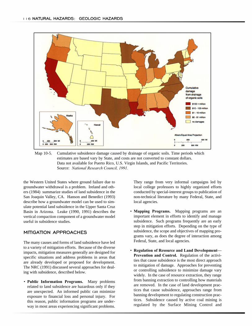
Map 10-5. Cumulative subsidence damage caused by drainage of organic soils. Time periods which estimates are based vary by State, and costs are not converted to constant dollars. Data not available for Puerto Rico, U.S. Virgin Islands, and Pacific Territories. Source: National Research Council, 1991.
the Western United States where ground failure due to groundwater withdrawal is a problem. Ireland and others (1984) summarize studies of land subsidence in the San Joaquin Valley, CA. Hanson and Benedict (1993) describe how a groundwater model can be used to simulate potential land subsidence in the Upper Santa Cruz Basin in Arizona. Leake (1990, 1991) describes the vertical compaction component of a groundwater model useful in subsidence studies.
MITIGATION APPROACHES
The many causes and forms of land subsidence have led to a variety of mitigation efforts. Because of the diverse impacts, mitigation measures generally are designed for specific situations and address problems in areas that are already developed or proposed for development. The NRC (1991) discussed several approaches for dealing with subsidence, described below.
• Public Information Programs. Many problems related to land subsidence are hazardous only if they are unexpected. An informed public can minimize exposure to financial loss and personal injury. For this reason, public information programs are under-way in most areas experiencing significant problems.
They range from very informal campaigns led by local college professors to highly organized efforts conducted by special-interest groups to publication of non-technical literature by many Federal, State, and local agencies.
• Mapping Programs. Mapping programs are an important element in efforts to identify and manage subsidence. Such programs frequently are an early step in mitigation efforts. Depending on the type of subsidence, the scope and objectives of mapping pro-grams vary, as does the degree of interaction among Federal, State, and local agencies.
• Regulation of Resource and Land Development— Prevention and Control. Regulation of the activities that cause subsidence is the most direct approach to mitigation of damage. Approaches for preventing or controlling subsidence to minimize damage vary widely. In the case of resource extraction, they range from banning extraction to controlling how materials are removed. In the case of land development practices that cause subsidence, approaches range from banning development to regulating construction practices. Subsidence caused by active coal mining is regulated by the Surface Mining Control and
RECOMMENDATIONS
BIBLIOGRAPHY AND REFERENCES
LAND SUBSIDENCELAND SUBSIDENCE 117
Reclamation Act of 1977, which requires coal mine operators to submit Subsidence Control Plans as part of permit applications. Around Houston, the Harris-Galveston Coastal Subsidence District regulates groundwater withdrawal through a permit process.
• Land-Use Management and Building Codes. Land-use management and regulation in the presence of real or potential subsidence is an alternative to regulating subsurface resource development. Techniques include land-use planning and codes, specialized building codes, official maps, and constraints on public utilities.
• Market-Based Mitigation Efforts. The objective of market-based efforts is to internalize the cost of subsidence by transferring those costs to the parties responsible for it or to the ultimate consumers. Internalizing subsidence costs may come about through taxes or fees on the parties causing the subsidence or by directly requiring those parties to carry out prevention measures.
• Insurance. Insurance programs to provide relief from subsidence damage have been used in several areas to distribute losses more equitably and to encourage risk reduction actions. Programs have been implemented to insure against losses from coal-mine subsidence and catastrophic subsidence associated with sinkhole collapse. The NFIP offers insurance in areas impacted by flooding aggravated by subsidence. Coal-mine subsidence insurance is avail-able in Pennsylvania, Illinois, West Virginia, and Kentucky, and is under consideration in other States. In 1981, sinkhole insurance coverage in Florida was extended to all structures, although insurance companies were given an option not to provide coverage for commercial and government buildings.
RECOMMENDATIONS
The National Research Council (1991) recommended efforts in three general areas to address subsidence problems:
• Collection of a broad range of earth science data in order to assess the incidence and potential impact from each type of subsidence, both locally and regionally;
• Technical research to improve the capability to predict the time, rate, magnitude, and place of subsidence, and to develop engineering designs that are resistant to subsidence damage; and
• Evaluation of methods of subsidence mitigation for cost effectiveness and suitability for each type of subsidence.
The NRC (1991) expressed concern that efforts to reduce the Federal deficit, which have jeopardized the small but effective subsidence research programs in Federal agencies, will halt scientific and technical progress. Data and research results from Federal pro-grams historically have complemented State and local efforts by establishing much of the technical basis for recognition of subsidence potential, as well as its prevention or mitigation. The NRC supported the maintenance of Federal budgets in order to provide data and techniques required by State and local governments and industry to mitigate subsidence in a timely and cost-effective manner.
BIBLIOGRAPHY AND REFERENCES
Arman, A., and S.I. Thornton, 1972. Collapsible Soils in Louisiana. Louisiana State University Engineering Research Bulletin No. 111.
Curtin, G. 1973. "Collapsing Soil and Subsidence." In: D.E. Moran and others (Eds.), Geology, Seismicity, and Environmental Impact. Association of Engineering Geologists.
Davies, W.E., J.H. Simpson, G.C. Ohlmacher, and G.J. Newton. 1976. Map Showing Engineering Aspects of Karst in the United States. Scale 1:7,500,000. U.S. Geological Survey Open-File Report 76-625.
Earle, D.W. 1975. Land Subsidence Problems and Maintenance Costs to Homeowners in East New Orleans, Louisiana. Ph.D. Dissertation. Louisiana State University.
Geotimes. 1988. “Kansas Sinkholes.” Vol. 33, No. 11, p. 15.
Hanson, R.T., and J.F. Benedict. 1994. Simulation of Groundwater Flow and Potential Land Subsidence, Upper Santa Cruz Basin, Arizona. U.S. Geological Survey Water, Resources Investigations Report 93-4196.
Hays, W.W. 1981. Facing Geologic and Hydrologic Hazards: Earth Science Considerations. U.S. Geological Survey Professional Paper 1240-B.
Holzer, T.L. 1989. "State and Local Response to Damaging Land Subsidence in United States Urban Areas." Engineering Geology. Vol. 27, pp. 449-466.
NATURAL HAZARDS: GEOLOGIC HAZARDS118 NATURAL HAZARDS: GEOLOGIC HAZARDS
Holzer, T.L. 1984. “Ground Failure Induced by Groundwater Withdrawal from Unconsolidated Sediments.” In: T.L. Holzer (Ed.), Man-Induced Land Subsidence. Geological Society of Amercia, Reviews in Engineering Geology. Vol. 6.
HRB-Singer, Inc. 1977. Nature and Distribution of Subsidence Problems Affecting HUD and Urban Areas. U.S. Department of Housing and Urban Development. National Technical Information Services. Report No. PB80172778.
HRB-Singer, Inc. 1980. Technical and Economic Evaluation of Underground Disposal of Coal Mining Wastes. Report prepared for Bureau of Mines. Contract No. J0285008.
Illinois Department of Energy and Natural Resources. 1985. The Economic Effects of Underground Mining Upon Land Used for Illinois Agriculture. Illinois Department of Energy and Natural Resources Document No. 85/01.
Ireland, R.L., J.F. Poland, and F.S. Riley. 1984. Land Subsidence in San Joaquin Valley, California, as of 1980. U.S. Geological Survey Professional Paper 437-I.
James, L.B. 1974. The Role of Engineering Geology in Building the California State Water Project. Centenaire de la Societe Geologique de Belgique Colloque. Geologie de L'Ingenieur, Liege.
Johnson, W., and G.C. Miller, 1979. Abandoned Coal-mined Lands: Nature, Extent, and Cost of Reclamation. U.S. Bureau of Mines Special Publication No. 6-79.
Jones, L.L. 1977. External Costs of Surface Subsidence: Upper Galveston Bay, Texas. International Association of Hydrological Sciences Publication No. 121.
Kaliser, B.N. 1982. "Hydrocompaction Affecting Cedar City, Utah." Proceedings of the 19th Engineering Geology and Soils Engineering Symposium. Pp. 145-160.
Leake, S.A. 1990. "Interbed Storage Changes and Compaction in Models of Regional Groundwater Flow." Water Resources Research. Vol. 26, No. 9, pp. 1939-1950.
Leake, S.A. 1991. "Simulation of Vertical Compaction in Models of Regional Groundwater Flow." Land Subsidence, Proceedings of the Fourth International Symposium on Land Subsidence. International Association of Hydrological Sciences Publication No. 200.
Mayuga, M.N. 1970. "Geology and Development of California's Giant-Wilimington Oil Field." Geology of Giant Petroleum Fields. American Association of Petroleum Geologists Memoir No. 14.
National Research Council. 1991. Mitigating Losses from Land Subsidence in the United States. Washington, D.C.: National Academy Press.
Newton, J.G. 1986. Natural and Induced Sinkhole Development in the Eastern United States. International Association of Hydrological Sciences Publication No. 151.
Penland, S., K.E. Ramsey, R.A. McBride, J.T. Mestayer, and K.AA. Westphal. 1988. Relative Sea Level Rise and Delta-Plain Development in Terrebonne Parish Region. Louisiana Geological Survey. Coastal Geology Publication Technical Report No. 4.
Prokopovich, N.P., and M.J. Marriott. 1983. "Cost of Subsidence to the Central Valley Project, California." Association of Engineers Geologists Bulletin 20. Vol. 3, pp. 325-332.
Roll, J.R. 1976. "Effect of Subsidence on Well Fields." American Water Works Association Journal. Vol. 59, No. 1, pp. 80-88.
Stephens, J.C., L.H. Allen Jr., and E. Chen. 1984. “Organic Soil Subsidence.” In: T.L. Holzer (Ed.), Man-Induced Land Subsidence. Geological Society of America, Reviews in Engineering Geology. Vol. 6.
Turney, J.E. 1985. Subsidence Above Inactive Coal Mines: Information for the Homeowner. Colorado Geological Survey Special Publication No. 26.

LAND SUBSIDENCELAND SUBSIDENCE 119

CHAPTERCHAPTER
11
EXPANSIVEEXPANSIVE SOILSSOILS
NATURAL HAZARDS:
Chapter Summary
GEOLOGIC HAZARDS122 NATURAL HAZARDS: GEOLOGIC HAZARDS
Chapter Summary
Soils and soft rock that tend to swell or shrink due to changes in moisture content are commonly known as expansive soils. Changes in soil volume present
a hazard primarily to structures built on top of expansive soils. The most extensive damage occurs to highways and streets.
In the United States, two major groups of rocks serve as parent materials of expansive soils, and occur more commonly in the West than in the East. The first group consists of ash, glass, and rocks of volcanic origin. The aluminum silicate minerals in these volcanic materials often decompose to form expansive clay minerals of the smectite group, the best known of which is montmorillonite. The second group consists of sedimentary rock containing clay minerals, examples of which are the shales of the semiarid West-Central States. Because clay materials are most susceptible to swelling and shrinking, expansive soils are often referred to as swelling clays.
The effects of expansive soils are most prevalent in regions of moderate to high precipitation, where prolonged periods of drought are followed by long periods of rainfall. The hazard occurs in many parts of the Southern, Central, and Western United States. Recent estimates put the annual damage from expansive soils as high as $7 billion. However, because the hazard develops gradually and seldom presents a threat to life, expansive soils have received limited attention, despite their costly effects.
The best means of preventing or reducing the damage from expansive soils is to avoid building on them. When that is not possible, commonly applied engineering practices include removal of the soil, application of heavy loads to offset the swelling pressure, preventing access to water, presetting, and chemical stabilization.
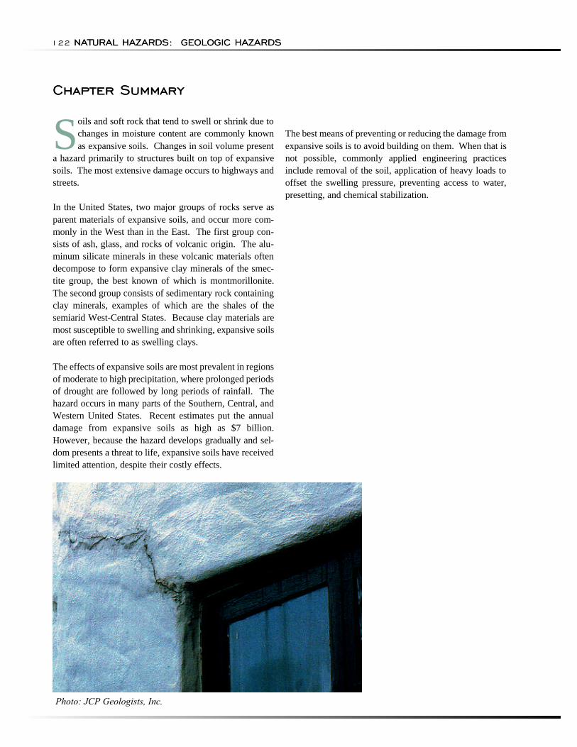
Photo: JCP Geologists, Inc.
EXPANSIVE SOILSEXPANSIVE SOILS 123
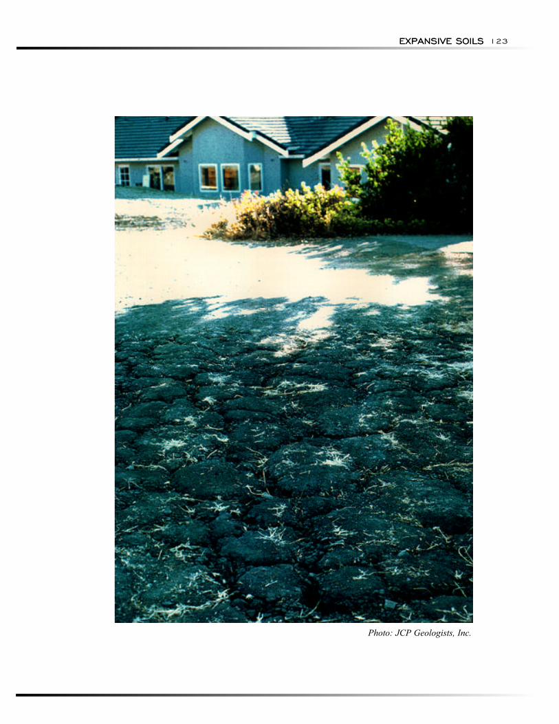
Photo: JCP Geologists, Inc.
NATURAL HAZARDS:
HAZARD IDENTIFICATION
RISK ASSESSMENT
Probability and Frequency
GEOLOGIC HAZARDS124 NATURAL HAZARDS: GEOLOGIC HAZARDS
HAZARD IDENTIFICATION
"Clay" is defined as a natural, earthy, fine-grained mate-rial that develops plasticity when mixed with a limited amount of water. A swelling clay, according to the American Geological Institute Glossary of Geology (Bates and Jackson, 1980), is a "clay that is capable of absorbing large quantities of water, thus increasing greatly in volume. . . ."
Dry clays that are capable of absorbing water, if unconfined, will increase in volume in an amount proportional to the amount of water absorbed. The amount of water absorbed and the degree of expansiveness are dependent on several variable and interrelated factors. The increase in soil volume causes damage to foundations and structures. These same clays may also be a source of engineering problems due to shrinkage resulting from loss of moisture.
Dry swelling clays absorb much larger quantities of water before becoming plastic than do dry, non-swelling clays. They also remain plastic over a wider range of moisture content, referred to as the plasticity index (PI). The PI is expressed as the numerical difference between the plastic limit (the percent moisture content at which clay passes from the solid to the plastic state) and the liquid limit (the percent moisture content at which clay passes from the plastic to the liquid state). The PI bears a direct relation to the amount and type of clay minerals present and to the orientation and size of clay particles. Other factors remaining constant, the PI increases with amount of clay minerals, decreases with degree of parallel orientation of the clay minerals, and decreases with clay particle size.
The plasticity index is generally a good indicator of swelling potential. Seed and others (1962), who found the PI to be the single most useful indicator of swelling potential, noted ". . . this parameter alone can provide an assessment of swelling that is probably accurate to with-in 35 percent." Sowers and Kennedy (1967) found the PI to be "the most reliable working tool" in identifying potentially troublesome clays in the humid coastal plains of the southeastern United States.
Expansive soils can be recognized either by visual inspection in the field or by conducting laboratory analyses. Shales, clay shales, weathered volcanic rocks, and residual soils containing smectite often have a characteristic "popcorn" texture, especially in semiarid areas.
The most successful methods of recognizing expansive soils involve laboratory analysis of the clay-mineral content in solid and soft rock, including X-ray diffrac
tion, differential thermal analysis, and microscopic examination. The most common methods used to identify expansive soils on the basis of physical characteristics related to volume change are free swell tests, plasticity tests, and direct measurements of volume change.
Swelling potential refers to the amount of volume increase due to swelling that is possible in a clay in its natural environment. Swelling potential is influenced by many factors, some of which are inherent to the clay and others that are related to its environment. Inherent factors determine the maximum increase in volume that can take place under optimum conditions, and include clay mineral composition, amount of non-clay material present, density, void ratio, size and orientation of clay particles, cementation, macrostructure, size and thickness of clay body, and depth below ground surface.
Volume changes in clay caused by variations in moisture content occur within approximately 30 ft (10 m) of the ground surface (Jones and Holtz, 1973). Most changes that cause engineering problems occur at depths less than 10 ft (3 m) (Hamilton, 1963; Gromko, 1974).
Clays beneath the water table have no swelling potential because they are completely saturated with no capacity for moisture absorption. Clays above the water table are generally unsaturated and will have capacities for moisture and swelling that will differ according to their degree of saturation. Generally, saturation levels are high and swelling potentials are low for clays just above the water table, because they have access to abundant moisture due to capillary action (Olive and others, 1989).
Clays in the weathering zone, which may extend to more than 30 ft (10 m) below the surface, usually have minimum moisture contents that are determined by climate. Variations in moisture content and volume changes are greatest in clays found in regions of moderate to high precipitation, where prolonged periods of drought are followed by long periods of rainfall. It is in these regions, which include many of the Southern, Central, and Western States, that swelling of clays resulting from climatic fluctuations cause the most severe engineering problems.
RISK ASSESSMENT
Probability and Frequency
The risk associated with expansive soils is related to swelling potential in a qualitative manner: high, moderate to slight, and little to no swelling potential. Swelling clay potential is defined in a spatial sense with
EXPANSIVE SOILS
Exposure
Consequences
EXPANSIVE SOILS 125
no implications over time. Probability and frequency analyses have not been prepared because of the nature of occurrence of this hazard. This is consistent with other geologic hazards that occur rarely or slowly over time.
Exposure
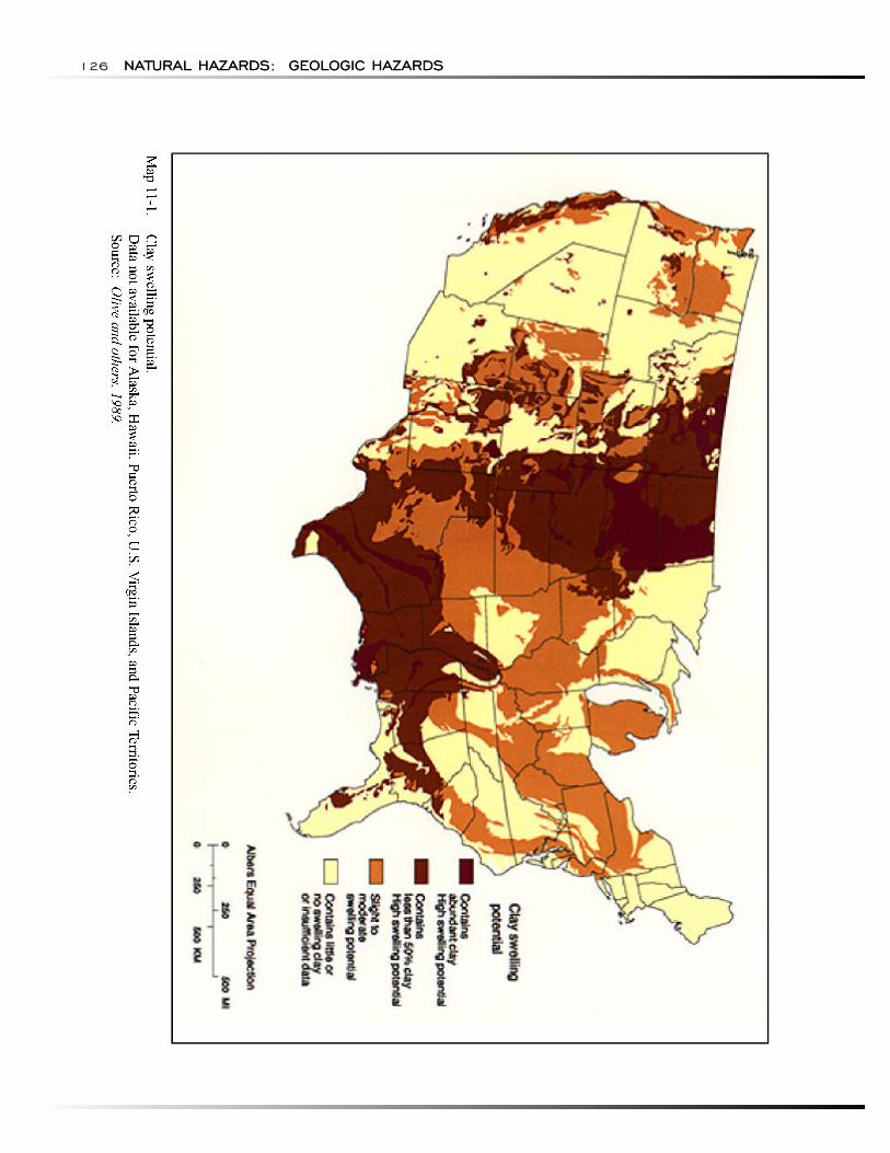
Olive and others (1989) developed a map of the conterminous United States to show the distribution and potential of swelling clays (Map 11-1). Geologic units as shown on the geologic map of the United States (King and Beikman, 1974) were classified according to the amount and swelling potential of clay they contain.
The availability of data on expansive soils varies greatly. In or near metropolitan centers and at dam sites, abundant information on the amount of clay generally is available. However, for large areas of the United States, little information is reported other than field observations of the physical characteristics of clay of a particular stratigraphic unit. Therefore, fixed criteria for determining the swelling potential have not been devised. The method adopted by Olive and others (1989) is largely subjective and the classification presented was based on the authors' appraisal of pertinent data that, for a single clay body or geologic unit, may vary considerably in quantity and quality from one area to another.
The swelling-clay classification of Olive and others (1989) was based mostly on numerous published descriptions of the physical and mineralogic properties of clays. Other data, often unpublished, were obtained from communication with practicing engineering geologists and geotechnical engineers. The map developed by Olive and others (1989) is consistent with maps developed by Patrick and Snethen (1976) and a map published by the American Society of Civil Engineers (ASCE) in Civil Engineering in October 1978.
Compared to Olive's map, another expansive soil map by Wiggins and others (1978) has similar patterns but some noticeable differences as well. The differences are due to the different approaches for identifying swelling clay potential. Wiggins used soil taxonomy obtained from the Soil Geography Unit of the U.S. Soil Conservation Service, while Olive related clay swelling potential to geologic units.
Consequences
Most engineering problems caused by volume changes in swelling clays result from human activities that modify the local environment. They commonly involve swelling clays beneath areas covered by buildings and
slabs or layers of concrete and asphalt, such as those used in construction of highways, canal linings, walk-ways, and airport runways.
Damage to the built environment results from differential vertical movement that occurs as clay moisture con-tent adjusts to the changed environment. In a highway pavement, differential movement of 0.4 in (1 cm) with-in a horizontal distance of 20 ft (6 m) is enough to pose an engineering problem if high standards for fast travel are to be maintained (Williams, 1965).
Buildings are capable of withstanding even less differential movement before structural damage occurs. Generally, a differential movement of 0.25 in (0.61 cm) between adjacent columns will cause cracking in load-bearing walls of a 20-ft wide (6-m wide) bay. With differential movement of 1.5 in (3.7 cm) over a span of 20 ft (6 m), beams are likely to be structurally damaged (Skempton and McDonald, 1956).
Houses and one-story commercial buildings are more apt to be damaged by the expansion of swelling clays than are multi-story buildings, which usually are heavy enough to counter swelling pressures. However, if constructed on wet clay, multi-story buildings may be dam-aged by shrinkage of the clay if moisture levels are substantially reduced, such as by evapotranspiration or by evaporation from beneath heated buildings.
The most obvious manifestations of damage to buildings are sticking doors, uneven floors, and cracked foundations, floors, walls, ceilings, and windows. If damage is severe, the cost of repair may exceed the value of the building.
Probably the greatest amount small building damage has impacted those constructed when clays were dry, such as during a drought, followed by soaking rains that prompt swelling of clays. Other reported cases of dam-age involve volume increases due to moisture from broken or leaking water and sewer lines, watering of lawns and shrubbery, and modifications of the surface that produce ponding (Olive and others, 1989).
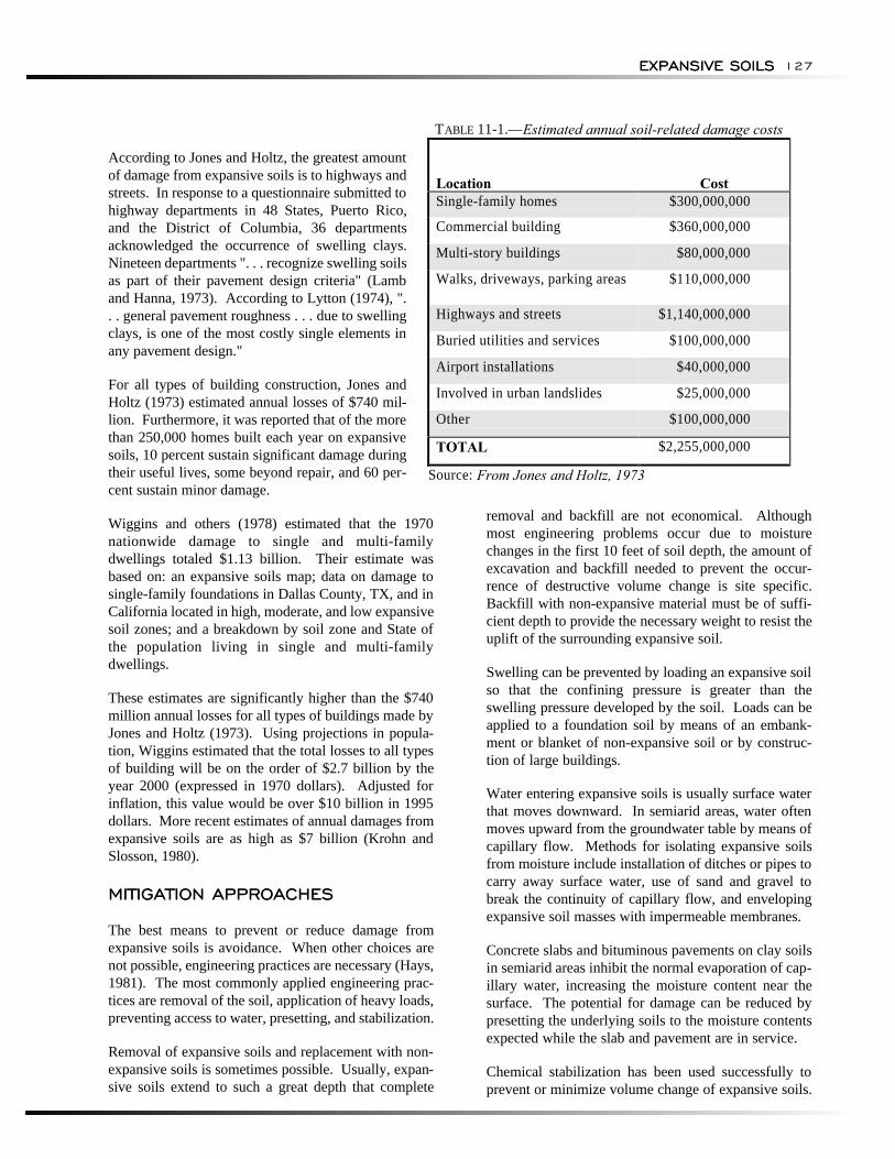
Jones and Holtz (1973) estimated the total annual expansive soil-related damage throughout the United States to be just under $2.5 billion (Table 11-1). This study represents a conservative estimate of the total damage attributed to expansive soils. Many problems are not recognized as being expansive-soil related or may be considered nuisances and not repaired. Also, these figures probably do not reflect the increased costs attributed to over-design of structures in areas either highly or moderately at risk for expansive soil problems (Wiggins and others, 1978).
NATURAL HAZARDS: GEOLOGIC HAZARDS126 NATURAL HAZARDS: GEOLOGIC HAZARDS
EXPANSIVE SOILS
MITIGATION APPROACHES
EXPANSIVE SOILS 127
TABLE 11-1.—Estimated annual soil-related damage costs
According to Jones and Holtz, the greatest amount of damage from expansive soils is to highways and streets. In response to a questionnaire submitted to highway departments in 48 States, Puerto Rico, and the District of Columbia, 36 departments acknowledged the occurrence of swelling clays. Nineteen departments ". . . recognize swelling soils as part of their pavement design criteria" (Lamb and Hanna, 1973). According to Lytton (1974), ". . . general pavement roughness . . . due to swelling clays, is one of the most costly single elements in any pavement design."
For all types of building construction, Jones and Holtz (1973) estimated annual losses of $740 mil-lion. Furthermore, it was reported that of the more than 250,000 homes built each year on expansive soils, 10 percent sustain significant damage during their useful lives, some beyond repair, and 60 per- Source: From Jones and Holtz, 1973
Location Cost Single-family homes $300,000,000
Commercial building $360,000,000
Multi-story buildings $80,000,000
Walks, driveways, parking areas $110,000,000
Highways and streets $1,140,000,000
Buried utilities and services $100,000,000
Airport installations $40,000,000
Involved in urban landslides $25,000,000
Other $100,000,000
TOTAL $2,255,000,000
cent sustain minor damage.
Wiggins and others (1978) estimated that the 1970 nationwide damage to single and multi-family dwellings totaled $1.13 billion. Their estimate was based on: an expansive soils map; data on damage to single-family foundations in Dallas County, TX, and in California located in high, moderate, and low expansive soil zones; and a breakdown by soil zone and State of the population living in single and multi-family dwellings.
These estimates are significantly higher than the $740 million annual losses for all types of buildings made by Jones and Holtz (1973). Using projections in population, Wiggins estimated that the total losses to all types of building will be on the order of $2.7 billion by the year 2000 (expressed in 1970 dollars). Adjusted for inflation, this value would be over $10 billion in 1995 dollars. More recent estimates of annual damages from expansive soils are as high as $7 billion (Krohn and Slosson, 1980).
MITIGATION APPROACHES
The best means to prevent or reduce damage from expansive soils is avoidance. When other choices are not possible, engineering practices are necessary (Hays, 1981). The most commonly applied engineering practices are removal of the soil, application of heavy loads, preventing access to water, presetting, and stabilization.
Removal of expansive soils and replacement with non-expansive soils is sometimes possible. Usually, expansive soils extend to such a great depth that complete
removal and backfill are not economical. Although most engineering problems occur due to moisture changes in the first 10 feet of soil depth, the amount of excavation and backfill needed to prevent the occurrence of destructive volume change is site specific. Backfill with non-expansive material must be of sufficient depth to provide the necessary weight to resist the uplift of the surrounding expansive soil.
Swelling can be prevented by loading an expansive soil so that the confining pressure is greater than the swelling pressure developed by the soil. Loads can be applied to a foundation soil by means of an embankment or blanket of non-expansive soil or by construction of large buildings.
Water entering expansive soils is usually surface water that moves downward. In semiarid areas, water often moves upward from the groundwater table by means of capillary flow. Methods for isolating expansive soils from moisture include installation of ditches or pipes to carry away surface water, use of sand and gravel to break the continuity of capillary flow, and enveloping expansive soil masses with impermeable membranes.
Concrete slabs and bituminous pavements on clay soils in semiarid areas inhibit the normal evaporation of capillary water, increasing the moisture content near the surface. The potential for damage can be reduced by presetting the underlying soils to the moisture contents expected while the slab and pavement are in service.
Chemical stabilization has been used successfully to prevent or minimize volume change of expansive soils.
RECOMMENDATIONS
BIBLIOGRAPHY AND REFERENCES
NATURAL HAZARDS: GEOLOGIC HAZARDS128 NATURAL HAZARDS: GEOLOGIC HAZARDS
The ionic character of the soil and water combination can be modified by the addition of certain chemicals, such as hydrated lime, to prevent volume change. This approach is based on studies that show that the ionic character of water has a major effect on volume change.
RECOMMENDATIONS
In contrast to earthquakes and landslides, expansive soil hazards are slow to develop and do not usually pose risks to public safety. Because of low visibility, this hazard has received relatively little attention in proportion to the projected annual damage.
Considerable data on swelling soils exist from construction in and around certain metropolitan areas, at dam sites, and other areas of construction of critical facilities. These data could be used to develop more quantitative methods of estimating the potential of future damage from expansive soils.
In areas where expansive soils create significant problems, procedures for control of new construction could be instigated in grading and building regulations, including proper slab design and emplacement procedures. Structural damage due to expansive soils is not covered by most insurance.
BIBLIOGRAPHY AND REFERENCES
Bates, R.L., and J.A. Jackson (Eds). 1980. Glossary of Geology. 2nd Edition. Washington, DC: American Geological Institute.
Building Research Advisory Board, National Research Council. 1968. "Criteria for Selection and Design of Residential Slab-on-ground." Federal Highway Administration Report No. 33. National Academy of Sciences Publication No. 1571.
Gromko, G.J. 1974. "Review of Expansive Soils." Journal of the Geotechnical Engineering Division. American Society of Civil Engineers. Vol. 100, No. GT6, pp. 667-687.
Hamilton, J.J. 1963. "Volume Changes in Undisturbed Clay Profiles in Western Canada." Canadian Geotechnical Journal. Vol. 1, No. 1, pp. 27-42.
Hays, W.W. (Ed). 1981. Facing Geologic and Hydrologic Hazards: Earth-Science Considerations. U.S. Geological Survey Professional Paper 1240-B.
Jones, D.E., and W.G. Holtz. 1973. "Expansive Soils—the Hidden Disaster." Civil Engineering. Vol. 43, No. 8, pp. 49-51.
King, P.B., and H.M. Beikman. 1974. Geologic Map of the United States (Exclusive of Alaska and Hawaii). Scale 1:2,500,000. U.S. Geological Survey.
Krohn, J.P., and J.E. Slosson. 1980. "Assessment of Expansive Soils in the United States." Proceedings of the Fourth International Conference on Expansive Soils. Volume 1, pp. 596-608.
Lamb, D.R., and S.J. Hanna. 1973. Summary of Proceedings of Workshop on Expansive Clays and Shales in Highway Design and Construction. Prepared for the Federal Highway Administration, Report No FHWA-RD-073-72. Washington, DC: U.S. Government Printing Office.
Lytton, R.L. 1974. "Expansive Clay Roughness in the Highway Design System in Active Clays in Engineering and Construction Practice." Association of Engineering Geologists Bulletin. Vol. 11, No. 4, pp. 399-419.
Olive, W.W., A.F. Chleborad, C.W. Frahme, J. Shlocker, R.R. Schneider, and R.L. Schuster. 1989. Swelling Clays Map of the Conterminous United States. U.S. Geological Survey Map I-1940.
Patrick, D.M., and D.R. Snethen. 1976. Expansive Earth Materials— a Survey by Physiographic Areas of Their Occurrence and Distribution. Vicksburg, MS: U.S. Army Corps of Engineers, Waterways Experiment Station.
Seed, H.G., R.J. Lundgren, Jr. 1962. "Prediction of Swelling Potential for Compacted Clays." Journal of Soil Mechanics and Foundations Division. American Society of Civil Engineers. Vol. 88, No. SM3, pp.53-87.
Skempton, A.W., and D.H. McDonald. 1956. "The Allowable Settlement of Buildings." Institute of Civil Engineers Proceedings. Vol. 5, Pt. 3, pp. 727-784.
Sowers, G.F., and C.M. Kennedy. July 1967. "High Volume Change Clays of the Southeastern Coastal Plain." Pan American Conference on Soil Mechanics and Foundations Engineering, 3rd (Caracas). Proceedings: Socieded Venezolana de Mecanica del Sueloe Ingeneria de Fundaciones. Vol. 2, pp. 99-120.
Wiggins, J.S., J.E. Slosson, and J.P. Krohn. 1978. Natural Hazards: Earthquake, Landslide, Expansive Soil Loss Models. Institute of Behavioral Science. the University of Colorado, Boulder, CO.

EXPANSIVE SOILSEXPANSIVE SOILS 129
Williams, A.A.B. 1965. "The Deformation of Roads Resulting from Moisture Changes in Expansive Soils in South Africa." Moisture Equilibria and Moisture Changes in Soils Beneath Covered Areas—A Symposium in Print (Aitchison, G.D., ed.). Sydney, Australia: Butterworths.