Embed Size (px)
Citation preview
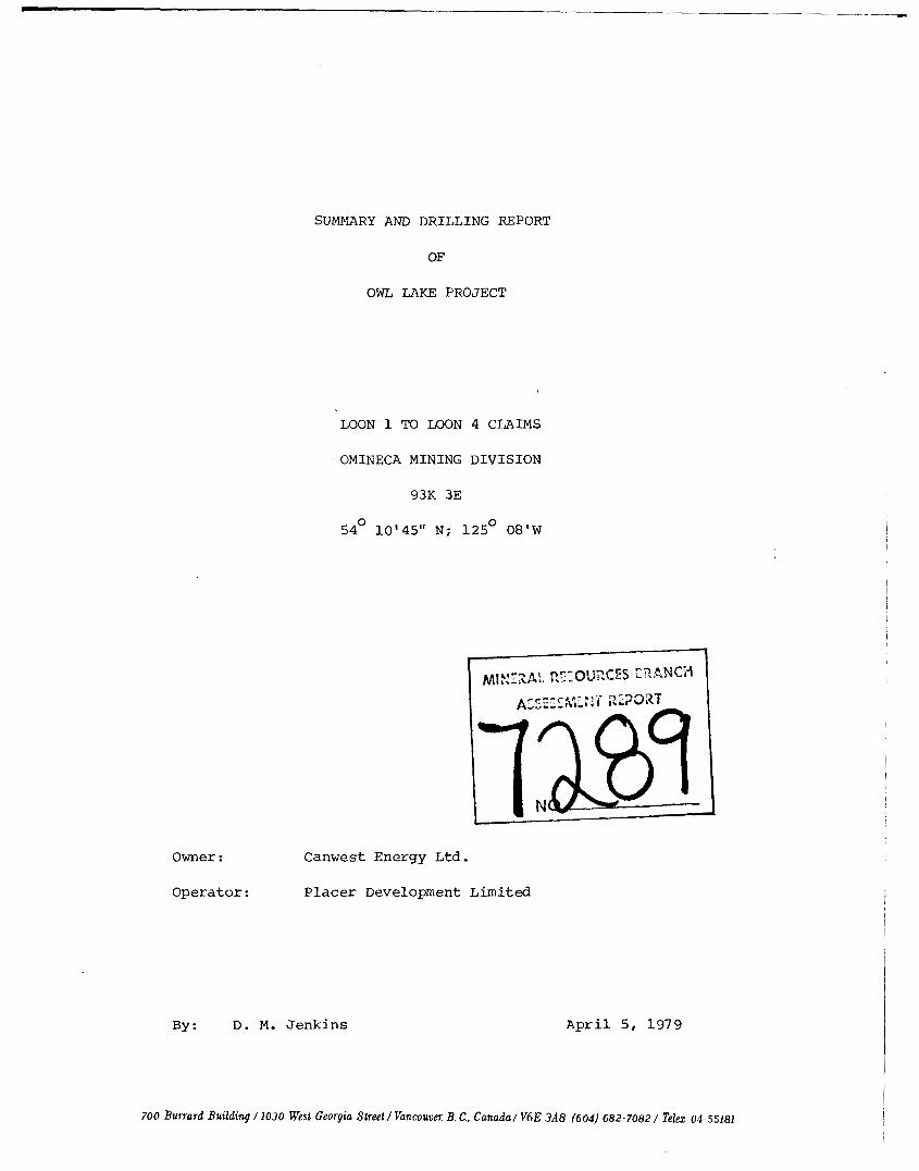
SUMMARY AND D R I L L I N G REPORT
OF
OWL LAKE PROJECT
LOON 1 TO LOON 4 CLAIMS
OMINECA MINING D I V I S I O N
93K 3E
54O 10'45" N; 1 2 5 O 08'W
Owner : C a n w e s t Energy L t d .
Operator: Placer D e v e l o p m e n t L i m i t e d
By : D. M. J enk ins A p r i l 5, 1979
700 Bussard Building / 1030 West Georgia Street/ Vancouvn; B. C., Canado/ V6E 3A8 (604) 682-7082/ T e h 04-55181
TABLE OF CONTENTS
Page N o .
SUMMARY
RECOMMENDATIONS
LOCATION AND ACCESS
PROPERTY AND OWNERSHIP
WORK PERFORMED
GEOLOGY
MINERALIZATION
STATEMENT OF QUALIFICATIONS
APPENDICES
1
2
3
3
6
1 3
2 0
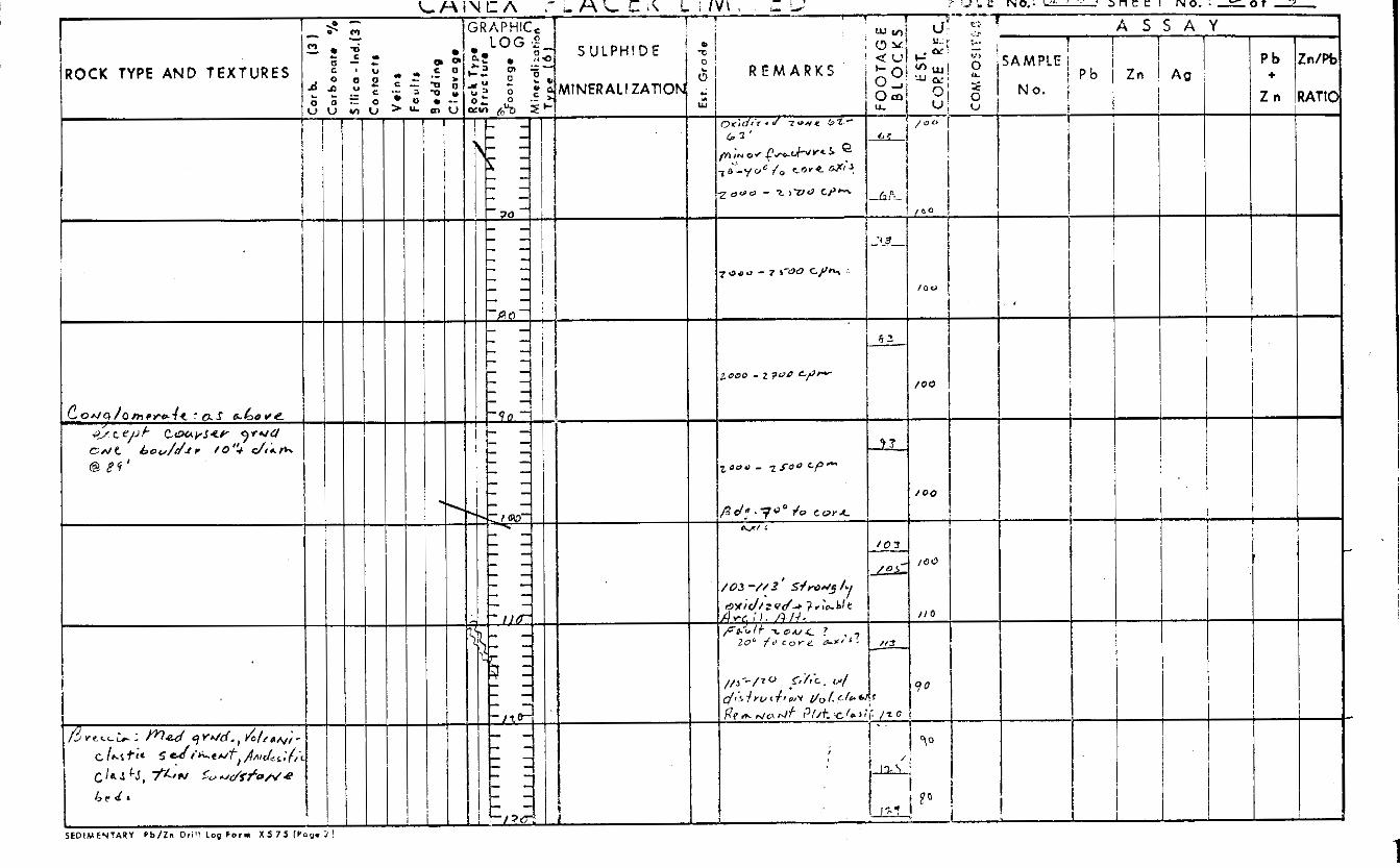
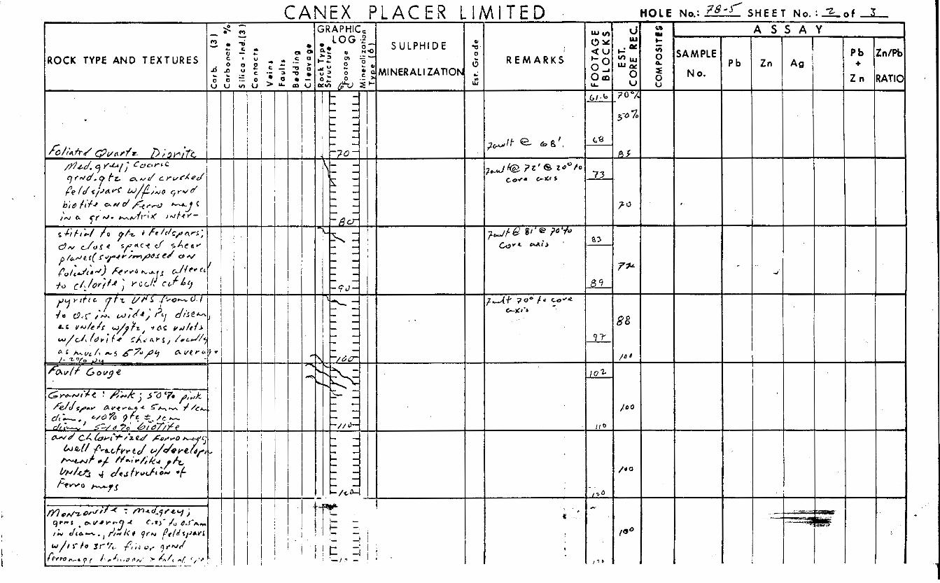
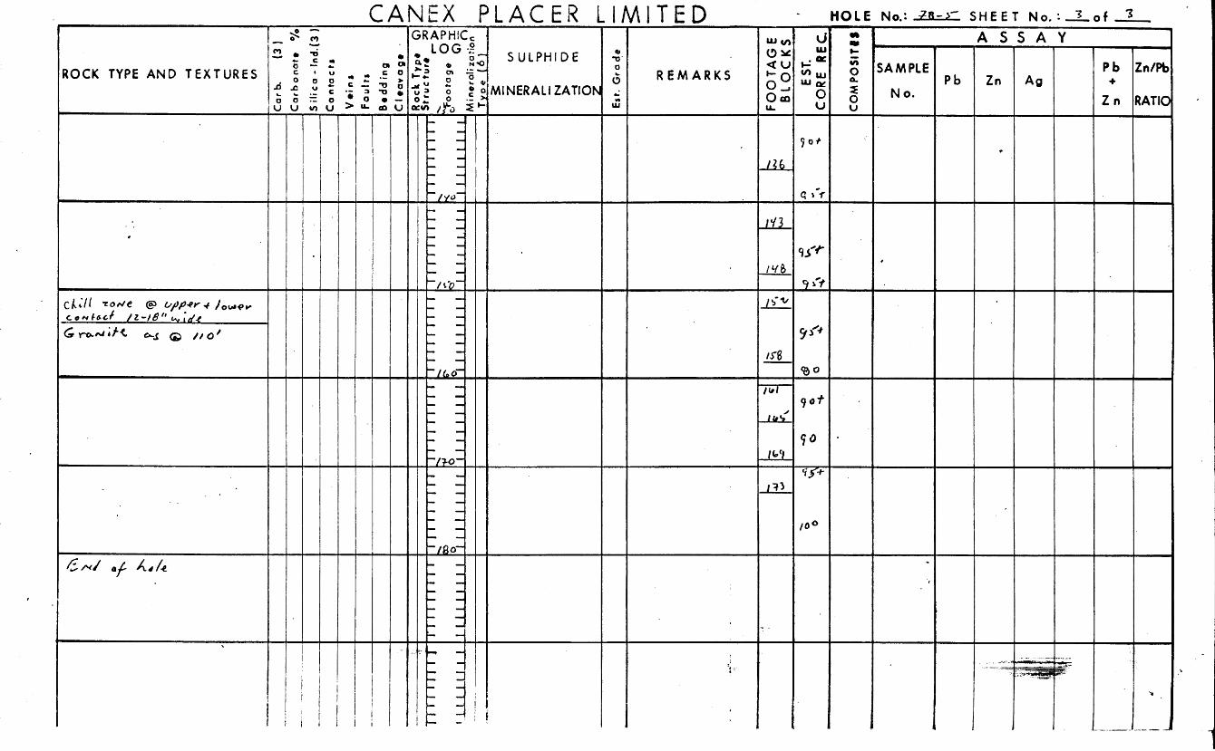
A p p e n d i x A 1978 D r i l l Logs
A p p e n d i x B Statement of C o s t s
LIST O F ILLUSTRATIONS
4 5
Figure I Location Map
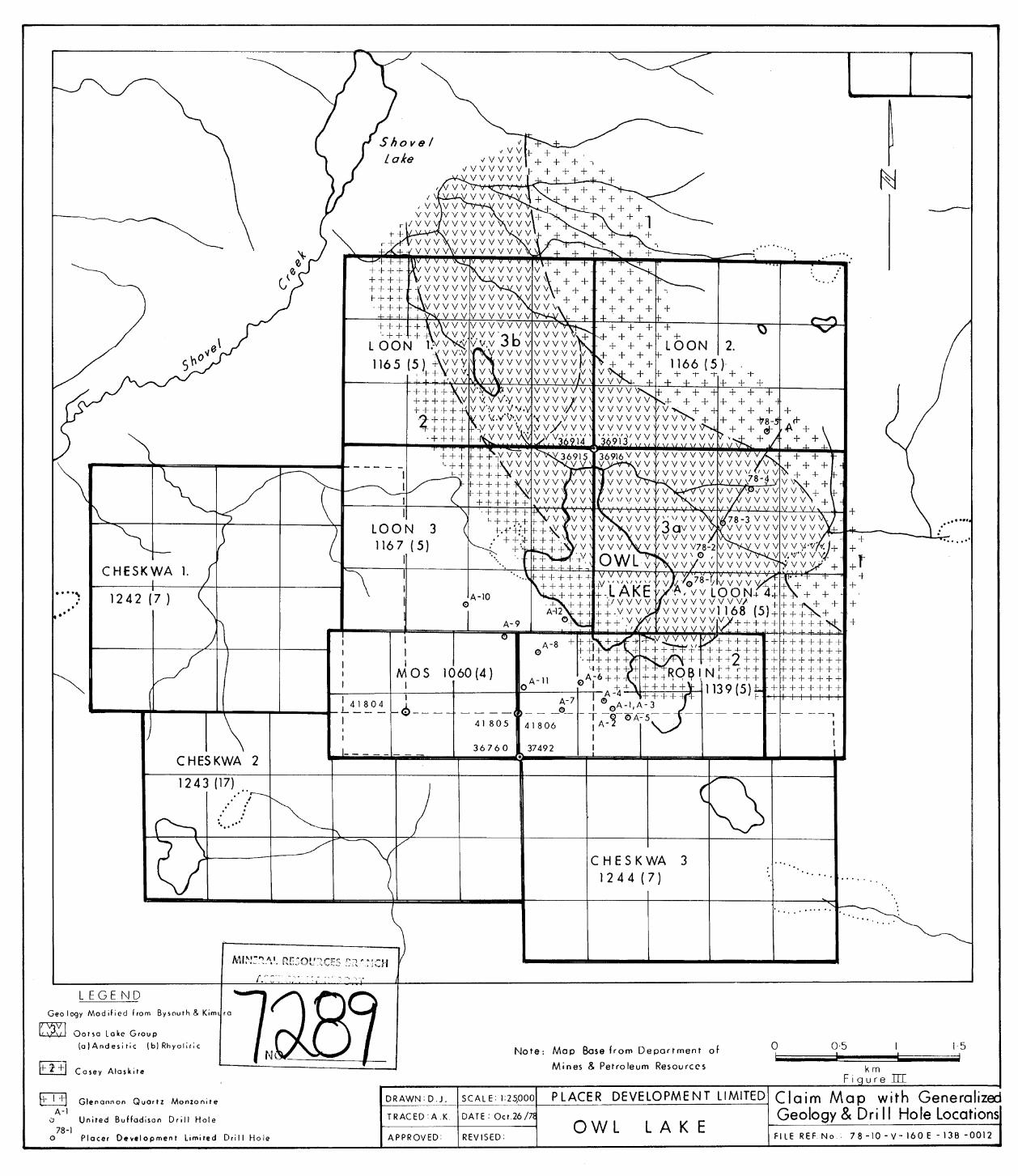
F igure 111 C l a i m Map w i t h G e n e r a i i z e d G e o l o g y and D r i l l H o l e Locations Pocket
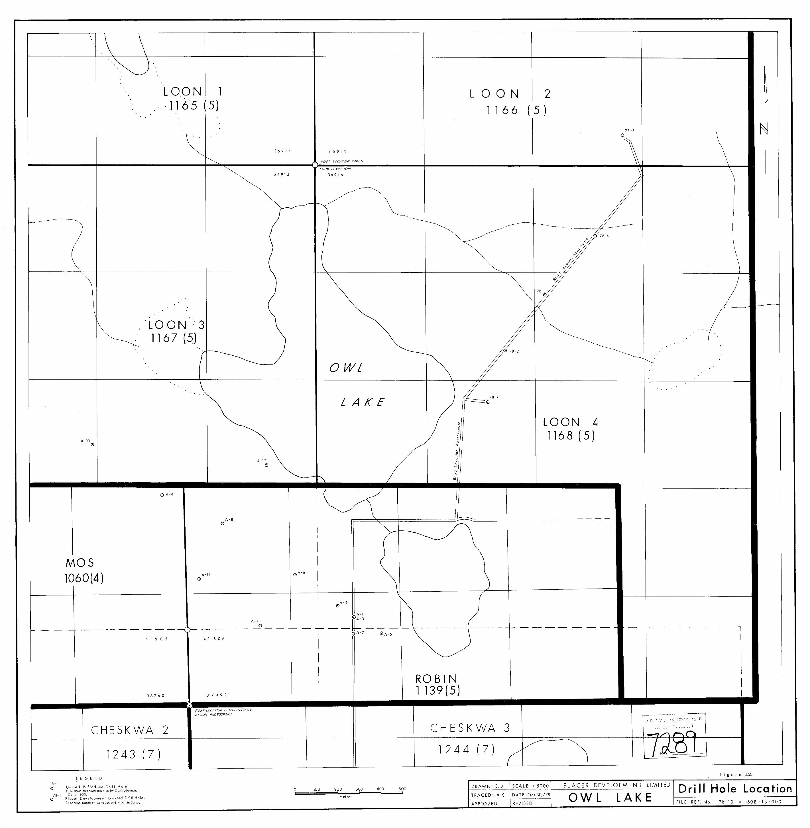
F igu re I V D r i l l H o l e Location Map Pocket
Figure V C r o s s Sect ion D i a m o n d D r i l l H o l e 78-1
F igure I1 Location Map J.
7 11 I 1 8 Figure V I 78-2 I1 I 1 9 Figure V I I I' 78-3 I 1 I 1 10 Figure V I I I I' 78-4 I 1 11 11 Figure I X 78-5
1 2
I 1 11
I 1 11
I 1 I 1
II 11
Figure X C r o s s Sect ion A-A Figure X I G e o l o g y from A e r o m a g n e t i c In te rpre ta t ion Pocket
71-10 Burrard Building / 1030 Test Georgia Street/ Vancouver; B C., Canada/ V6E 3A8 (604) 682-70821 Telez 04-55181
SUMMARY
A p o t e n t i a l basal uranium explora t ion t a r g e t was acquired
and diamond d r i l l e d .
volcanic rocks i n unconformable and f a u l t contac t with Topley p lu ton ic
rocks and Quartz D i o r i t e Complex.
t o 1 .5 m i l e s wide and a t l e a s t 3 miles long. The l eng th i s open t o
t h e southeas t where t h e volcanic rocks could be i n con tac t with high
uranium background p l u t o n i c rocks.
The t a r g e t c o n s i s t s of a b e l t of O o t s a Lake
The b e l t of volcanic rocks is 0.5
Five diamond d r i l l ho les were d r i l l e d i n a pane l a c r o s s t h e
outcrop b e l t . None of t h e ho le s pene t ra ted an unfaul ted volcanic-
p l u t o n i c contac t . I n one h o l e 600 f e e t of volcanic rock were d r i l l e d
without pene t r a t ing through t h e volcanic sec t ion .
conglomerate was pene t ra ted i n one d r i l l hole , however i t s s t ra t i -
Vo lcan ic l a s t i c
graphic p o s i t i o n i s ambiguous.
Anomalous uranium w a s no t encountered i n t h e sedimentary
sec t ion . A sample r ep resen t ing 1.1 meters of s i l i c i f i e d and breccia-
t e d r h y o l i t e w a s found by chemical a n a l y s i s t o conta in 25 ppm U.
Strong d i sequ i l ib r ium i n d i c a t e s t h e r ecen t emplacement of t h i s
uranium. Another sample of i n t e n s e l y s i l i c i f i e d a n d e s i t e contained
1.98 p p m gold.
Continued exp lo ra t ion is recommended. The program recom-
mended c o n s i s t s of a magnetic survey followed by l imi t ed diamond
d r i l l i n g . The est imated c o s t of t h e program is $35,000.00.
...... 2
700 Burrard Building 11030 West Georgia Street / Vancouver; B C, Canadal V6E 3A8 (604) 682-7082 1 Telex 04 55181
- 2 -
RECOMMENDATIONS
Because of t h e ques t ions concerning t h e loca t ions of t h e
volcanic- in t rus ive contac t i n a r e a s of cover and t h e depth of t h e
volcanic rocks over t he Topley i n t r u s i v e s a program of magnetic
and VLF electromagnetic geophysics should be c a r r i e d o u t p r i o r t o
f u r t h e r d r i l l i n g .
s u s c e p t i b i l i t y i n c o n t r a s t t o t h e r e l a t i v e l y weak magnetic suscep t ib i l -
i t y of the surrounding ac id p l u t o n i c rocks .
survey c a r r i e d o u t over coarse ly spaced l i n e s should r e a d i l y i n d i c a t e
t h e con tac t between t h e two l i t h o t y p e s .
diamond d r i l l i n g t o be s i t e d i n accordance wi th t h e r e s u l t s of t h e
geophysical surveys i s a l s o recommended. This d r i l l footage i s t o be
expended i n t h e determinat ion of t h e presence or absence of permeable
b a s a l sediments. The t o t a l es t imated cost of t h e recommended program
is $35,000.00.
The bas i c volcanic rocks e x h i b i t a s t rong magnetic
Therefore a magnetic
Budgeting f o r 1,500 f e e t of
.... 3
700 Burrard Building / 1030 West Georgia StreetlVancouvn: B C, Canada/ V6E 3A8 (604) 682-7082/ Telex 04.55181
- 3 -
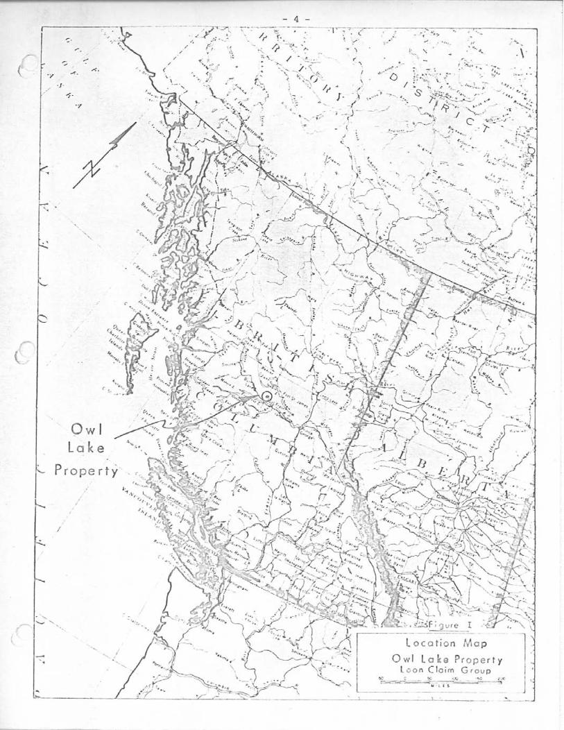
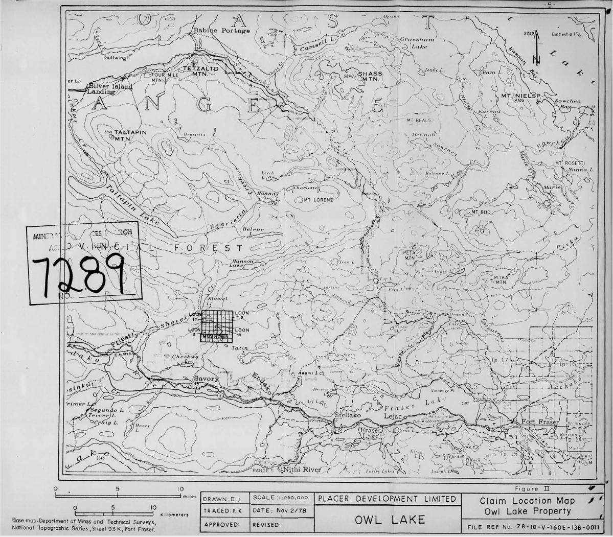
LOCATION AND ACCESS
The proper ty is loca ted 4.5 mi les nor th of Savory Siding
which is on t h e Canadian Nat ional Railway ( see F igures I and 11) and
7 m i l e s northwest of t h e Endako community. This l o c a t i o n i s approx-
imately 125O08' w e s t and 5 4 O 1 1 ' nor th . Access t o t h e p rope r ty i s by
a four wheel d r i v e passable , g rave l road which begins 1 .3 mi les e a s t
of Savory o r approximately 5 mi l e s w e s t of Endako, B. C.
Extensive i n f r a s t r u c t u r e e x i s t s i n t h e a rea . A r a i l s id ing ,
gas p i p e l i n e and e lectr ic power t ransmission l i n e a l l e x i s t wi th in
s i x mi les of t h e c l a i m group.
PROPERTY AND OWNERSHIP
The O w l Lake p rope r ty w a s optioned by Placer Development
Limited from Canwest Energy Ltd.
A p r i v a t e r e p o r t by B. Fraser states t h e O w l Lake Prospect
" c o n s i s t s of 64 claims." The Loon Group as s taked c o n s i s t s of 64 u n i t s
(Figure 111).
o f f i c e a t Smithers, B.C. show t h e following claims, which cover much
of t h e same ground, p reda te t h e Loon Group:
However, claim maps on f i l e i n t h e Mining Recorder 's
Mos Claim: 6 u n i t s
Robin Claim: 8 u n i t s
Therefore as many as 14 u n i t s of t h e Loon Group may be s taked
i n contravent ion. Furthermore Mos and Robin p o s t s a s l oca t ed on t h e
ground are no t placed as ind ica t ed on t h e claim m a p . These claims
..I. 4
700 Burrard Building / 1030 West Georgia Sweet / Vancouver B C. Canada,' V6E 3A8 (604) 682 7082 / Te1e.z 04-55181
-P-
- 6 -
may be located 800 f e e t w e s t of t h e l o c a t i o n p l o t t e d on t h e claim
m a p .
c r u c i a l should mine ra l i za t ion be loca ted i n t h e southern p o r t i o n
of t h e claim group.
The need f o r a claim survey is c l e a r l y ind ica ted and becomes
WORK PERFORMED
I n i t i a l a p p r a i s a l of t h e prospect cons is ted of reviewing
t h e geology a s mapped and i n t e r p r e t e d by E. Kimura and t h e Endako
Mine s t a f f (Figure 111). This ind ica ted t h e p o s s i b l e ex i s t ence of
an environment favourable for t h e depos i t i on of "basal" uranium
depos i t s . During a subsequent f i e l d examination f l o a t of immature
epiclastic sediments w a s located.
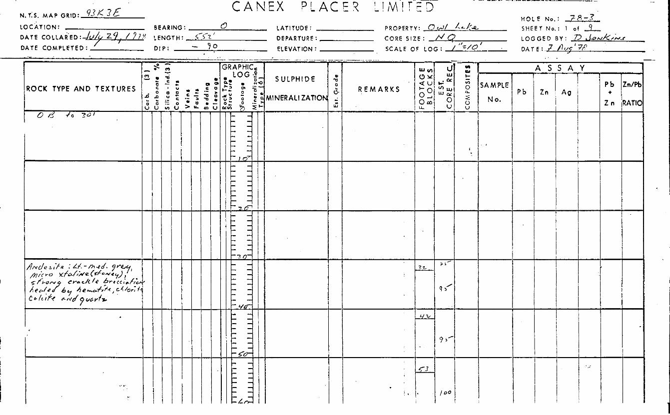
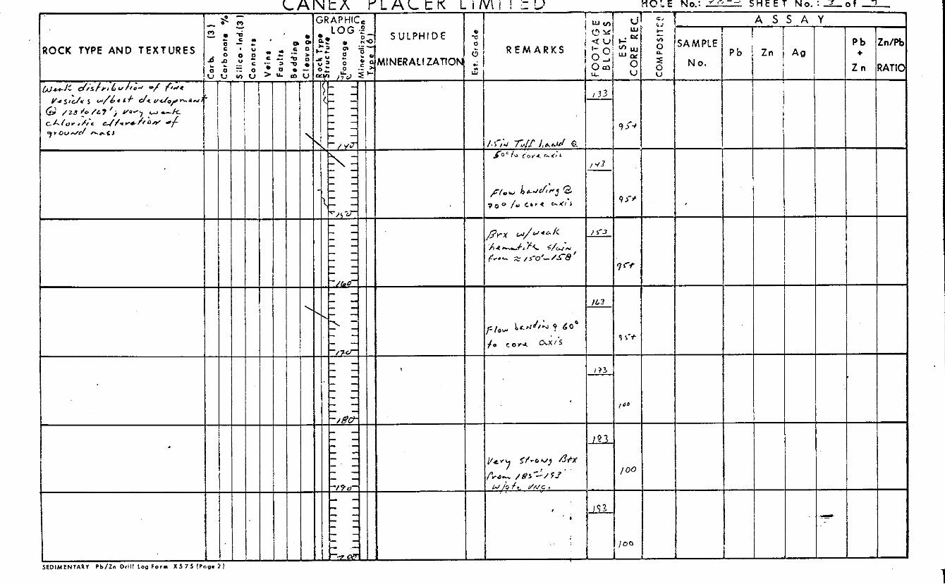
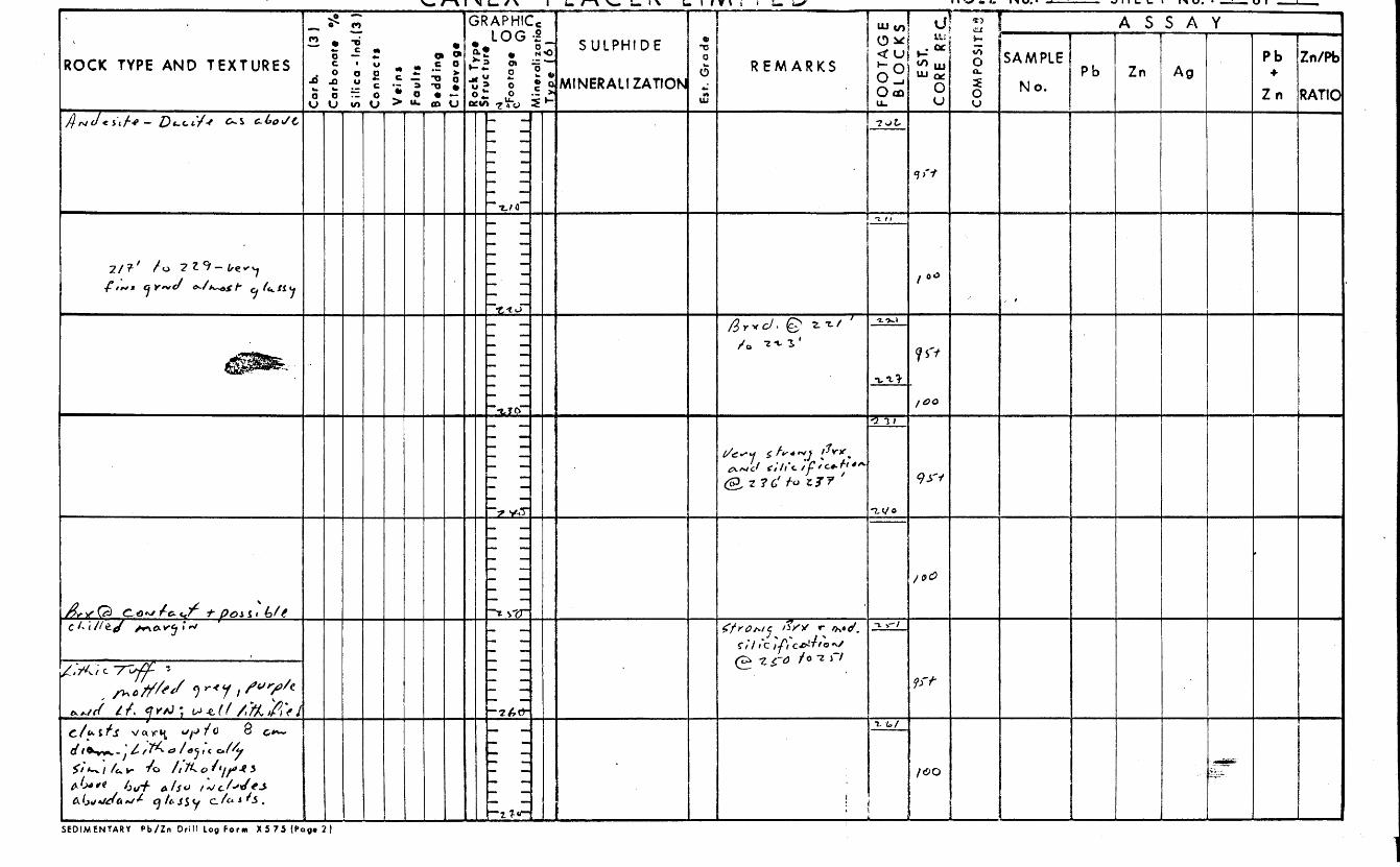
"NQ" s i z e d r i l l h o l e s w a s d r i l l e d ac ross t h e a x i s of t h e "basin"
(Figure I V ) .
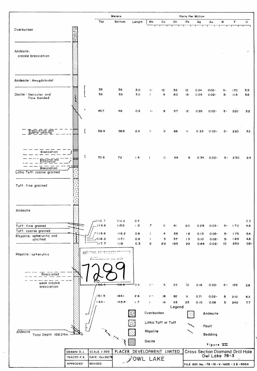
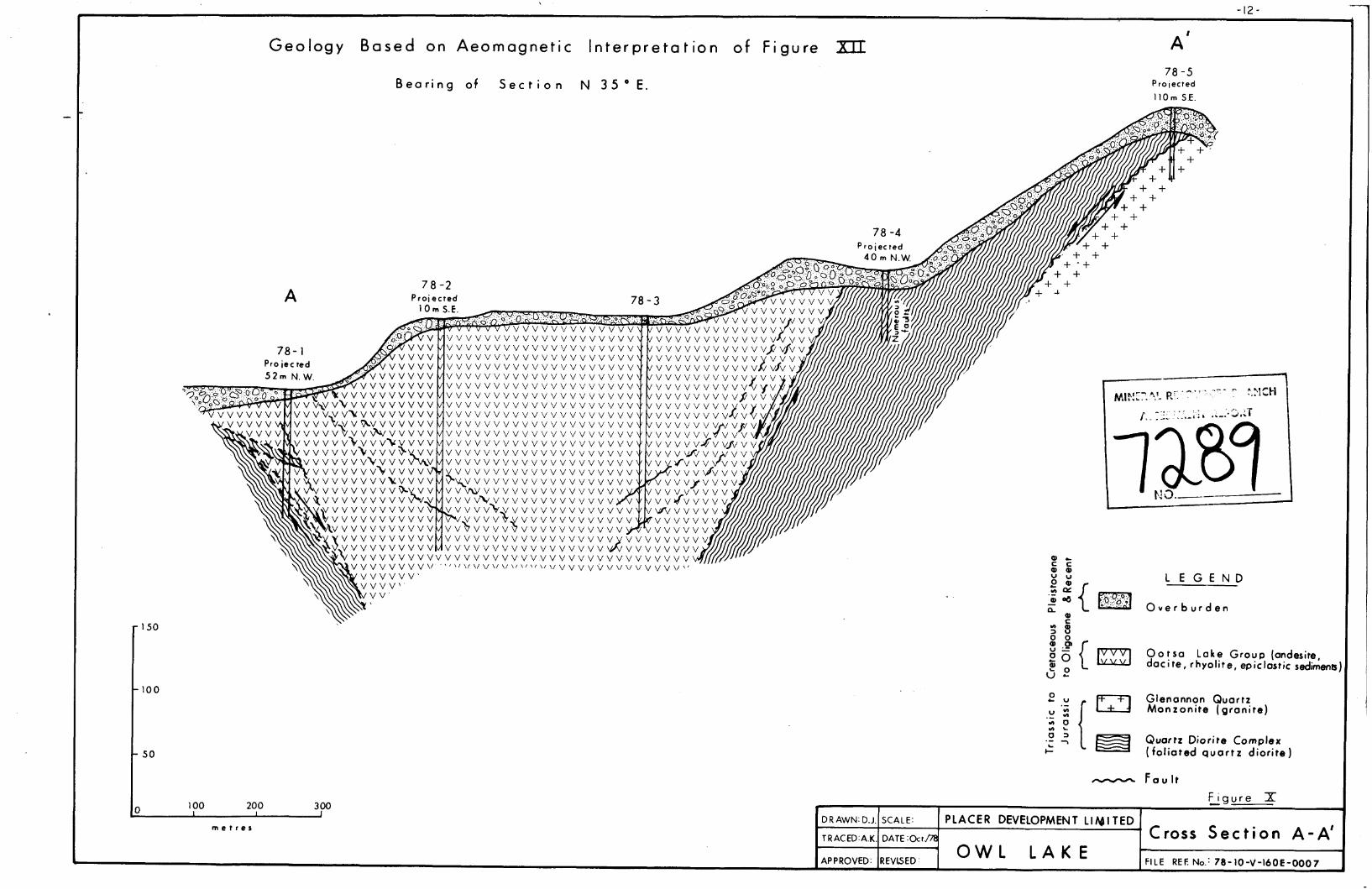
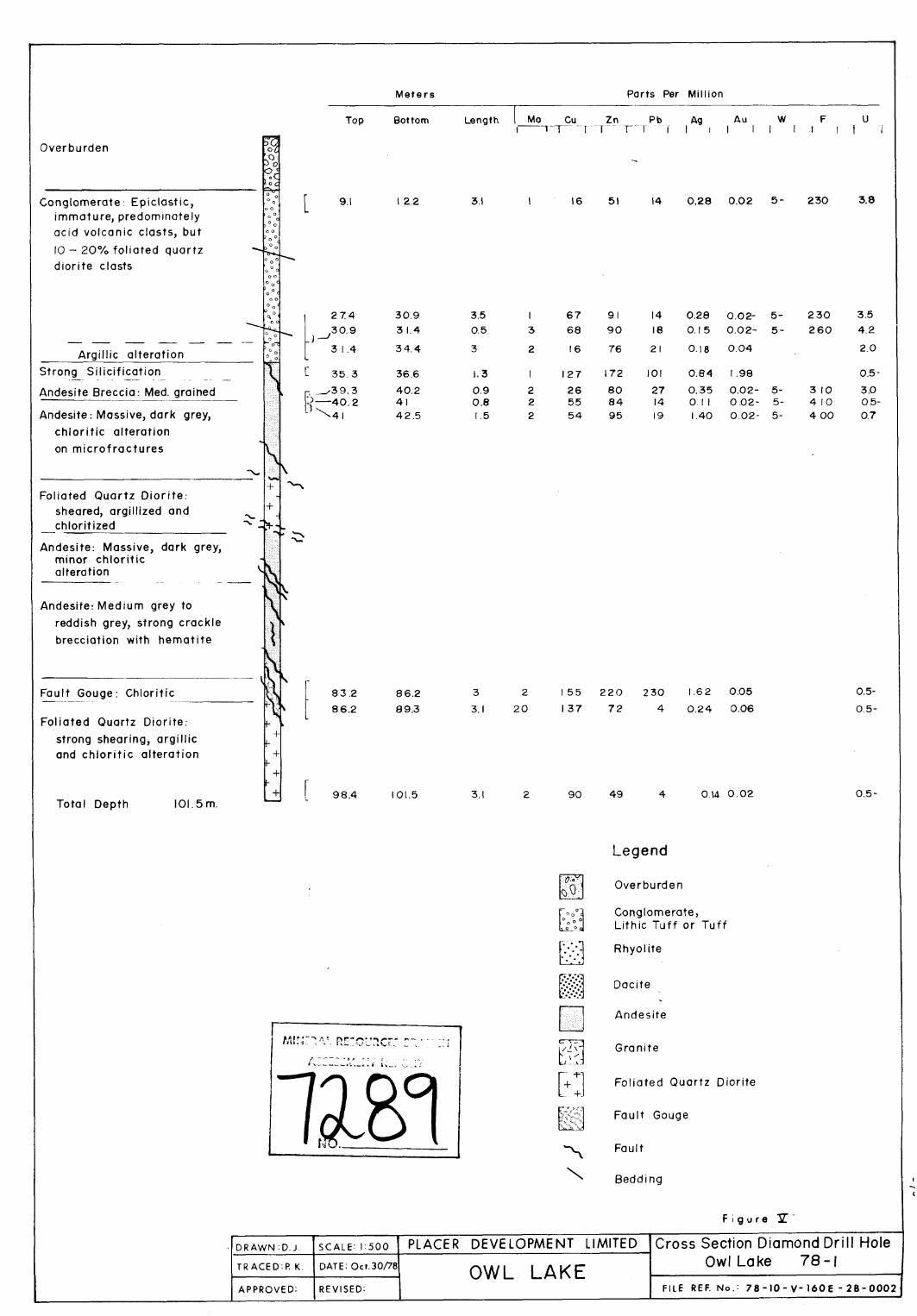
Ind iv idua l d r i l l h o l e sec t ions comprise f i g u r e s V through I X . A
cross sec t ion of t h e d r i l l ho le panel i s shown i n F igure X . The
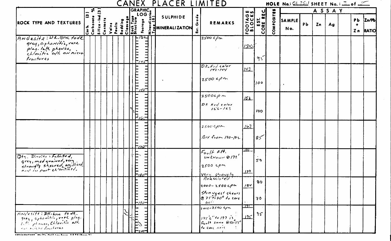
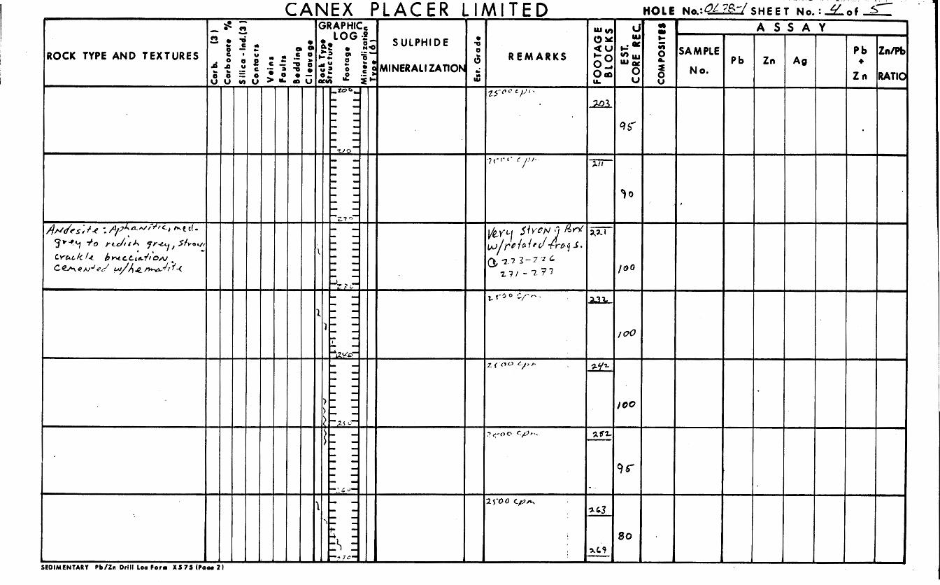
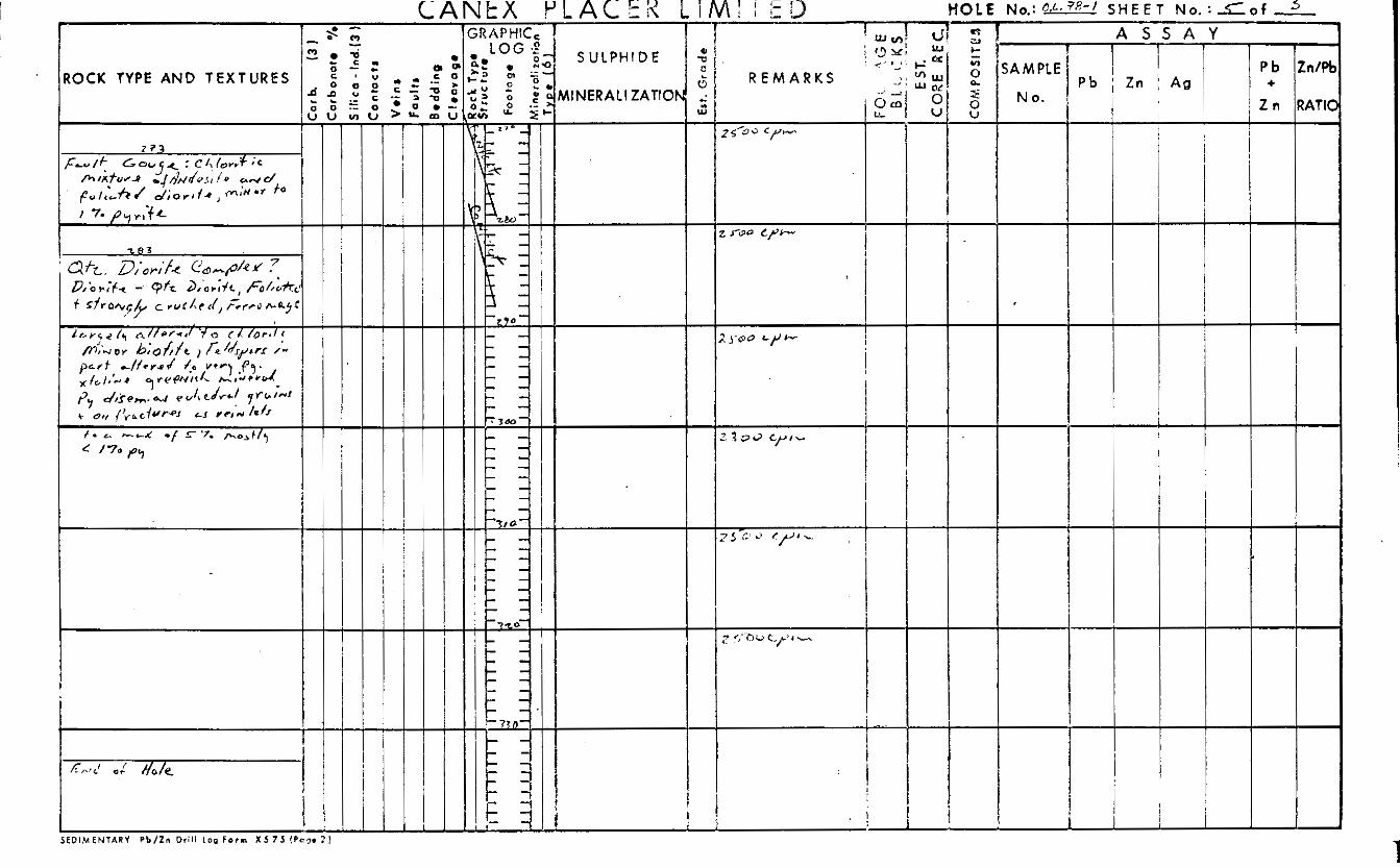
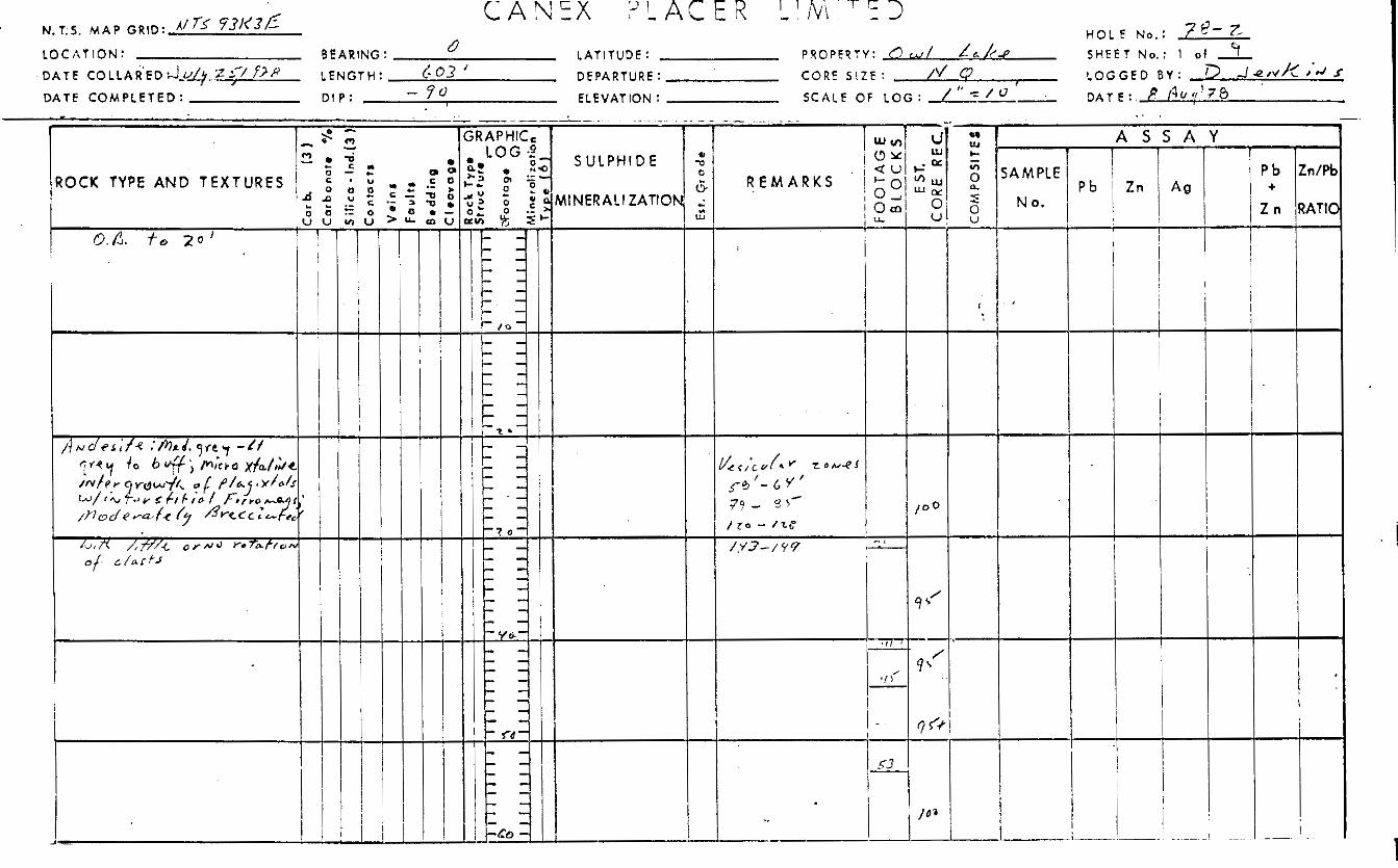
d r i l l logs comprise Appendix A of t h i s report.
Subsequently a panel of f i v e
The d r i l l ho les t o t a l e d 567.2 meters i n length .
700 Bursard Building / 1030 Vest Georgia Street / Vancouver B. C , Canada/ V6E 3A8 (604) 682-7082 / Telez 04-55181
- 13 -
GEOLOGY
The o l d e s t rocks known t o outcrop on t h e claim group a r e
a c i d i c phases of t h e Topley i n t r u s i v e s (Figure 111). D r i l l i n g has
ind ica t ed t h e presence i n t h e subsur face of an o l d e r rock u n i t , t h e
Quartz D i o r i t e Complex.
i s a southeas t t rending b e l t of vo lcan ic rocks which have been co r re l a -
t e d with t h e Ootsa Lake group.
f l u v i a l ma te r i a l s t h e d i s t r i b u t i o n of rock types i s very imprecisely
known and i n l a r g e p a r t is i n t e r p r e t e d from a i rbo rne magnetometer
d a t a .
Unconformably over ly ing t h e s e p lu ton ic u n i t s
Because of a t h i c k mantle of g l a c i a l -
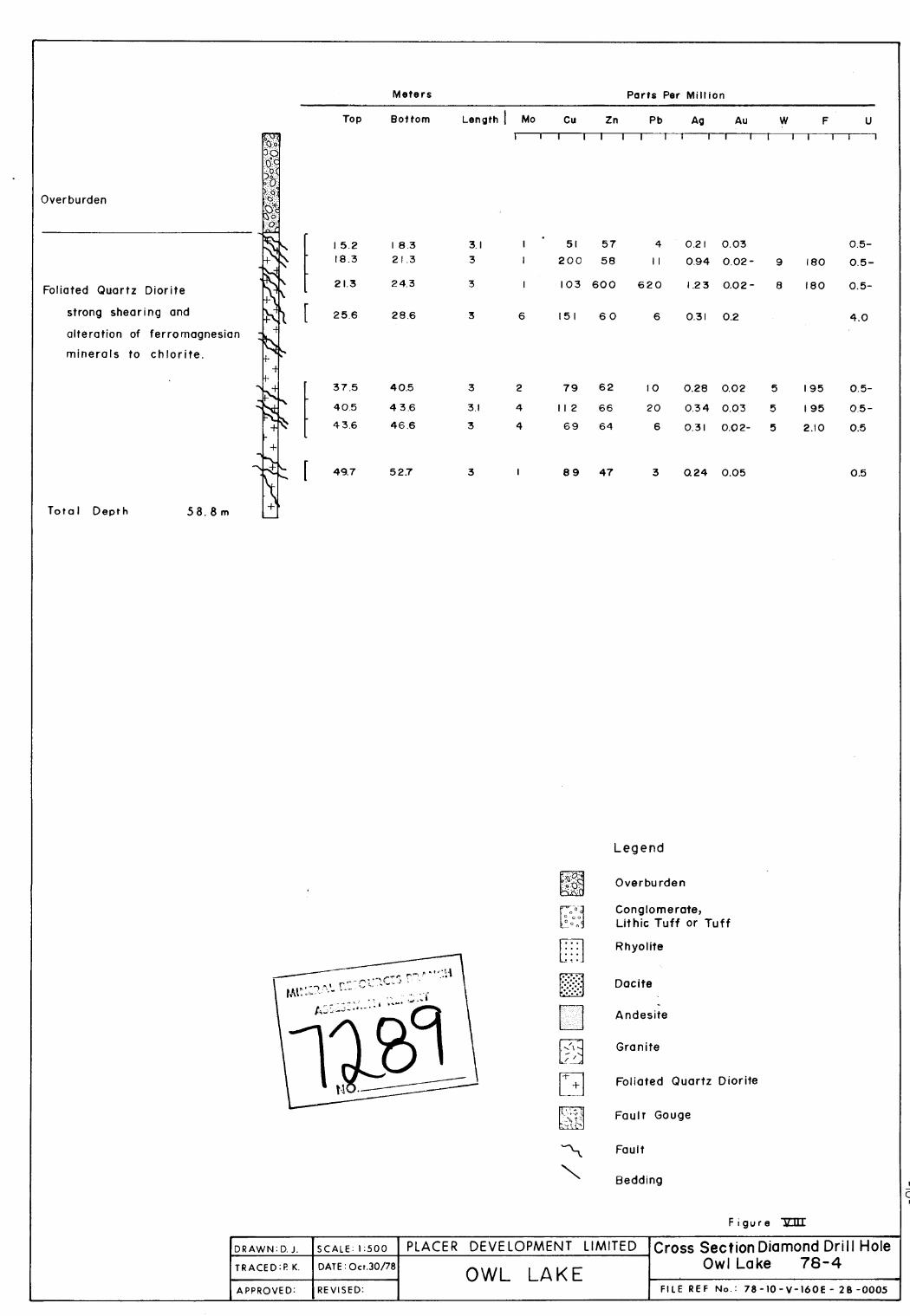
The f o l i a t e d qua r t z d i o r i t e which a t t h i s l o c a l i t y i s known
only from d r i l l ho le i n t e r s e c t i o n s probably belongs t o t h e Quartz ,
Diori te Complex of Triassic (?) age. The rock i s moderately f o l i a t e d ,
bu t f o l i a t i o n has i n p a r t been des t royed by la te r crushing. The
f e l s i c components a r e medium gra ined .
c r y s t a l s and as anhedral aggregates .
a r e megascopically deformed by crushing or bending.
a l t e r a t i o n is ubiqui tous i n t h e f e l d s p a r s . Secondary ep idote occurs
in f requent ly . Quartz occurs as anhedra l g ra ins . These also have been
broken i n t o aggregates of small fragments. The ferromagnesian minera ls
which occurred i n t e r s t i t i a l l y t o t h e f e l s i c minera ls have been l a r g e l y
a l t e r e d t o f i n e grained c h l o r i t e and smeared along shear p lanes with
d i v e r s e a t t i t u d e s . Because of t h i s smearing t h e rock i n e f f e c t has a
pseudo-glomeroporphyritic t ex tu re .
P l ag ioc la se occurs a s euhedral
The euhedral c r y s t a l s f r equen t ly
Weak a r g i l l i c
P y r i t e l o c a l l y comprises 5% of
..... 14
700 Burrard Building / 1030 West Georgia Street/ Vancouvm B C. Canada/ V6E 3A8 (604) 682-7082 1 Telez 04-55181
- 14 -
t h e rock i n a r e a s of s t rong f r a c t u r i n g . I t is m o s t abundant on shear
planes.
The outcropping p lu ton ic rocks have been d iv ided i n t o two
map u n i t s , t h e Glenannan Quartz Monzonite and t h e Casey Grani te . These
rocks range from Lower T r i a s s i c to Upper J u r a s s i c i n age.
The Glenannan Quartz Monzonite c o n s i s t s of pink coarse grained
subporphyr i t ic g r a n i t e t o quar tz Monzonite. Tex tu ra l ly t h e rock i s
composed of anhedral l i g h t grey qua r t z and p ink o r t h o c l a s e i n t e r s t i t i a l
t o subhedral f e ldspa r c r y s t a l s . The rock has a color index of 5 t o
8 percent . The mafic component c o n s i s t s l a r g e l y of b i o t i t e with subor-
d i n a t e hornblende. S p a t i a l l y these rocks are found nor theas t of t h e
volcanic b e l t .
The Casey Grani te i s a f i n e t o medium grained l e u c o c r a t i c
g r a n i t e . Local ly pegmatitic f a c i e s e x i s t . Extreme t e x t u r e v a r i a t i o n s
occur over s h o r t i n t e r v a l s and are t y p i c a l l y observed i n ind iv idua l
outcrops.
percent of t h e rock. Approximately 10 pe rcen t p l ag ioc la se is also
present . The c o l o r index i s approximately 3 . The mafic component
is b i o t i t e and/or c h l o r i t e . Local ly t h e qua r t z is dark grey. Within
t h e reg ion m i a r o l i t i c c a v i t i e s conta in ing pu rp le f l u o r i t e are known.
The Casey G r a n i t e s occur southeas t and southwest of t h e volcanic b e l t .
Quartz and o r thoc la se each comprise approximately 40 t o 45
Topley p lu ton ic rocks immediately east of t h e Loon C l a i m
Group are marked by an anomalously high uranium background i n t h e
stream sediment geochemistry. This s igna tu re i s so
. . . .E
700 Burrard Building / 1030 West Georgia Street / Vancouver B C. Canadal V6E 3A8 (604) 682 7082 / Tela 04 55181
‘ 7
:,acc.cl t h a t it must i nd ica t e !; rgh uraniiim 1 . 1 ~ * k g i ound le~lc.1 s
i n i 11c: ull(!erlying Casey Grani te . i . . i tI t;lcrmnnan QlI<irtz Monzonite i i l t r u -
i q - T; I ,,>c>.\ (.an t ~ ~ p t - p f c , i + ? cmnsicicarcd source . i rcas for
i‘ e i I ’ i f ; on i-lbp Toon (:Jaims.
0 &,-lying t h e Topley r t x - k s 31-12 A 1iite o f ba, ic
t o r h y o l i t i c volcanics .
Lake Group volcanics which range i n age from cre taceous t o Olicjo-
cene. Ho\,ever, t he s t r a t i g r a p h i c a l l y h ighes t lx i sa l t s may belong
t o t h e Endako Group which i s i n p a r t younger than Oligocene. The
volc;lliic:.; ’t,,ive d combined th i ckness i n excess of 600 f e e t on t h e
These hdve becn [ u t r r l a t e d with t h e Ootsa
‘I=
LL~Lng j rclljional b a s i s has ~ ~ ~ I ~ I u I ~ ~ ’ f r i i . cc i i . i c j t ; h e Ootsa
Lake Group equivalent may be loose ly subdivided i n t o two u n i t s .
u n i t c o n s i s t s predominantly of l e u c o c r a t i c s i l i c i c l i t h o t y p e s . ‘r’nL
o t h e r u n i t c o n s i s t s predominantly of mesoc I a t i c t o melanocrdiil:
s i l i c i c rock types. These u n i t s a r e b r i e f l y descr ibed below.
The s i l i c i c l i t h o t y p e s range i n co lo r from buff t o white t o
l i g h t 9,rey. The dist i nc t ion i n t h i s s t i idy between rhyolite iind d a c i t e
was made l a rge ly on the h n k - i s o f c o l o r . The white .Lo L ~ t f colored
v a r i e t i e s were c l a s s i f i e d as r h y o l i t e s , whereas t h e l i g h t grey v a r i e t i e s
and i n p a r t i c u l a r those with a p u r p l i s h hue were c lassed a s d a c i t e s .
D i f f e r e n t i a t i o n of l i t h o t y p e s w a s based on co lo r because t h e rocks
a r e only sparse ly p o r p h y r i t i c with qua r t z , f e ldspa r and b i o t i t e . The
homogeneous groundmass of t h e s e rocks ranges i n t e x t u r e from crypto-
17 c r y s t a l l i n e t o mic roc rys t a l l i ne . Sphe ru l i t e s a r e abundant i n .....

- 16 -
t h e f i n e r grained r h y o l i t i c s ec t ions . Tuffaceous f a c i e s a l s o occur .
Cer ta in of t h e massive r h y o l i t e u n i t s may be welded t u f f beds.
The s u b s i l i c i c vo lcanics were c l a s s i f i e d as a n d e s i t e s l a r g e l y
on t h e basis of t h e i r medium t o dark grey co lo ra t ion and s t ronge r i r o n
s t a i n i n brecc ia ted sec t ions . The groundmass of t hese rocks is t y p i c a l l y
microcrys ta l l ine .
a r e p re sen t bu t t y p i c a l l y comprise less than 5% of t h e rock.
l o c a l l y phenocrysts do comprise 15-20% of t h e rock m a s s .
F ine gra ined phenocrysts of p l ag ioc la se and b io t i te
Very
Vesicular and amygduli t ic s e c t i o n s occur spo rad ica l ly i n t h e
a n d e s i t i c sec t ion . The amygdules are va r ious ly composed of qua r t z ,
c a l c i t e and c h l o r i t e .
Volcanic conglomerates, b recc i a s and t u f f s comprise a s i g n i f i c a n t
po r t ion of t h e volcanic sec t ion .
r e l a t e d t o f a u l t s . I n o t h e r cases t h e evidence i s not clear and t h e
b recc ia s were poss ib ly generated by explosive volcanism o r e p i c l a s t i c
reworking of o lder vo lcanic and p l u t o n i c rocks. While l i t h o l o g i c a l l y
heterogeneous c l a s t i c l i t h o t y p e s are known, l i t h o l o g i c a l l y homogeneous
types a r e more common.
v a r i e t y of intermediate rock types. However, angular t o subrounded
clasts of f o l i a t e d qua r t z d i o r i t e comprise seve ra l percent of t h e
l i t h o l o g i c a l l y heterogeneous volcanic conglomerate in t e r sec t ed near t h e
top of ho le 78-1.
e p i c l a s t i c rocks are unknown on t h e O w l Lake property, with t h e excep-
t i o n of t h e prev ious ly mentioned f l o a t near ho le 78-1.
Ce r t a in of t h e b recc ia s are obviously
The clasts have l a r g e l y been generated from a
Surface exposures of t h i s rock type and a s soc ia t ed
These rocks are
.... 18
700 Burrard Building / 1030 West Georgia Street/ Vancouver: B C. Canada/ V6E 3A8 (604) 682-7082 / Telex 04-55181
- 17 -
t e x t u r a l l y and minera logica l ly immature wi th t h e except ion of t h i n
moderately so r t ed sandstone beds. F o s s i l p l a n t d e b r i s w a s not observed.
The e x o t i c f o l i a t e d quar tz d i o r i t e clasts i n t h e volcanic con-
glomerate and t h e water l a i n epiclastic sandstones were o r i g i n a l l y
i n t e r p r e t e d as ind ica t ing depos i t i on wi th in t h e dra inage of a through
flowing f l u v i a l system. The i n t e r p r e t a t i o n w a s based l a r g e l y on t h e
presence of t h e quar tz d i o r i t e c las ts as they are der ived from a map
u n i t , which w a s no t known t o e x i s t i n t h e immediate v i c i n i t y of O w l
Lake. Subsequently a f a u l t wedge of t h i s u n i t w a s i n t e r s e c t e d i n
diamond d r i l l ho le 78-1. Af te r p e n e t r a t i n g t h e wedge of quar tz
d i o r i t e t h e d r i l l passed i n t o another vo lcan ic sec t ion . A t g r e a t e r
depth t h e s e volcanics w e r e found t o be i n f a u l t con tac t with another '
s e c t i o n of f o l i a t e d qua r t z d i o r i t e i n which t h e ho le w a s terminated.
Work t o date has not def ined t h e s t r u c t u r e of t h e volcanic
"basin" b u t it has produced d a t a i n d i c a t i n g t h e s t r u c t u r e i s consider-
a b l y more complex than previous ly a n t i c i p a t e d .
f low banding i n t h e volcanic s e c t i o n demonstrate d i p s as g r e a t as 40
degrees bu t average about 20 degrees.
is s m a l l bu t would s e e m t o i n d i c a t e t h e ex i s t ence of only g e n t l e t o
moderate d ips . Sparse sur face d a t a i n d i c a t e a gene ra l no r theas t e r ly
d i p f o r t hese beds.
Bedding p lanes and
This popula t ion of da t a p o i n t s
F a u l t s a r e abundant i n t h e diamond d r i l l core. A t t i t u d e s of
f a u l t s range from near ho r i zon ta l t o v e r t i c a l . The s t r i k e s of t he
f a u l t s are n o t def ined by hard d a t a , however, t h e s t r i k e s of t h e major
.... 19
700 Busrard Building / 1030 West Georgia StreetlVancouver B C , Canada/ V6E 3A8 (604) 6 8 2 - 7 0 8 2 / Telex 04-55181
- 18 -
f a u l t s are assumed t o p a r a l l e l t h e northwest t r end ing outcrop b e l t
of vo lcanics which t r a v e r s e s t h e claim group. Movement on t h e f a u l t s
has r e s u l t e d i n t h e gene ra l s t r u c t u r a l lowering of t h e a r e a i n which
t h e volcanic rocks a r e preserved. However t h e i n t e r c a l a t i o n by
f a u l t i n g of a block of f o l i a t e d quar tz d i o r i t e i n t o t h e volcanic
sec t ion i n drill ho le 78-1 could be i n t e r p r e t e d as an i n d i c a t i o n of
a r e v e r s a l i n d i r e c t i o n of f a u l t movement.
The presence o f f o l i a t e d quar tz d i o r i t e i n t h e d r i l l ho les
and t h e absence of qua r t z d i o r i t e outcrop on t h e surrounding h i l l s i d e
i n d i c a t e t h a t t h i s l i t h o t y p e i s preserved only i n t h e lowland a reas .
These areas he re to fo re were thought t o be under la in only by O o t s a
Lake Group volcanic rocks. The f o l i a t e d qua r t z d i o r i t e may be a
wedge of country rock preserved between t h e t w o g r a n i t i c i n t rus ions .
A l t e rna t ive ly it may be i n a f a u l t block down dropped i n t o t h e Topley
i n t r u s i v e s , a p o s i t i o n which p ro tec t ed it dur ing t h e e ros iona l cyc le
which s t r ipped t h e cover from the Topley i n t r u s i v e s . I n e i t h e r case
t h e f o l i a t e d rock would have been more e a s i l y eroded than t h e surround-
ing massive i n t r u s i v e and as a r e s u l t may have unde r l a in t h e v a l l e y
of a stream d ra in ing t h e region during t h e cycle .
The presence of t h e Ootsa Lake Group vo lcan ic s i n a topo-
g raph ica l ly low area surrounded by Topley i n t r u s i v e s i n d i c a t e s an
anomalously l o w s t r u c t u r a l p o s i t i o n f o r t h e s e rocks.
t o depos i t ion i n t h e v a l l e y of a stream flowing t o t h e northwest or
t o being down dropped by f a u l t i n g , or more l i k e l y t o a combination
This may be due
.... 20
700 Burrard Building / 1030 West Georgia Street / Vancouver. B C. Canada/ V6E 3A8 (604) 682-7082 / Telex 04-55181
- 19 -
of topographical ly l o w depos i t i ona l s i t e and down f a u l t i n g .
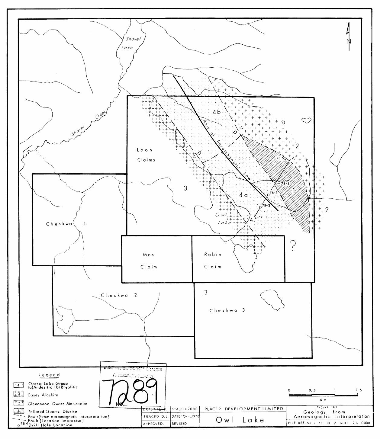
A study of t h e aeromagnetic map 5304G covering t h e O w l Lake
region w a s undertaken by L. W. Freeman i n an e f f o r t t o determine t h e
a r e a l ex ten t of t h e volcanic rocks. H e found t h e b e l t o f vo lcan ic s
no r theas t of Owl Lake i s marked by a magnetic l o w . The a x i s of t h e
trough p l o t s between d r i l l ho le s 78-2 and 78-3 Figure X I i l l u s t r a t e s
another i n t e r p r e t a t i o n of t h e observed geology based on Freeman's
i n t e r p r e t a t i o n of t h e aeromagnetic da t a . Freeman i n t e r p r e t s t h e
contoured aeromagnetic d a t a t o i n d i c a t e t w o aeromagnetic l i n e a r s
bounding t h e volcanic b e l t t o t h e no r theas t and t h e southwest. These
f e a t u r e s a r e wel l def ined a t t h e p o s i t i o n of t h e d r i l l hole pane l and
t o t h e northwest of t h e panel . Southeast of t h e panel t h e f e a t u r e s '
are poorly defined. The sparse d i s t r i b u t i o n of outcrops a l lows t h e
i n t e r p r e t a t i o n of t h e s e l i n e a r s as f a u l t s bounding a downdropped
volcanic block northwest of t h e d r i l l ho le panel.
A degree of ambiguity e x i s t s i n t h e i n t e r p r e t a t i o n . The
observed magnetic s u s c e p t i b i l i t i e s of t h e rocks from t h e area do not
agree with t h e aeromagnetic s igna ture . The a n d e s i t i c vo lcanic rocks
which under l ie t h e aeromagnetic low demonstrate a high magnetic
s u s c e p t i b i l i t y i n c o n t r a s t to t h e low magnetic s u s c e p t i b i l i t i e s of
t h e g ran i to ids t o t h e no r theas t of t h e volcanics . Therefore it
would appear t h a t t h e aeromagnetic d a t a which seems t o d e f i n e t h e
volcanic b e l t i n a r e a s where outcrop con t ro l i s a v a i l a b l e can no t be
used with confidence i n covered a r e a s t o t h e southeas t . Deta i led
.... 2 1
700 Burrani Building 1 1030 West Georgia Street/Vancouvel: B C, Canada, 1'6E 3A8 (604) 682-7082/ Telex 04-55181
- 20 -
ground magnetic surveys w i l l be requi red t o i n d i c a t e t h e d i s t r i b u t i o n
of volcanic rocks sou theas t of t h e 1978 d r i l l hole pane l .
The ques t ion of f l u v i a l sedimentation wi th in t h e s t r u c t u r a l
bas in and p rese rva t ion of t h e s e sediments remains t o be answered.
The v o l c a n i c l a s t i c sediments of ho le 78-1 may indeed be near t h e base
of t h e l o c a l p o s t Topley s t r a t i g r a p h i c sec t ion . Unfortunately t h e
r e l a t i o n s h i p i s obscured by a f a u l t con tac t with t h e basement i n t h e
only hole pene t r a t ing through t h e volcanic sediment cover. Continued
explora t ion f o r sediments favourable f o r t h e depos i t ion of basal
uranium depos i t s probably s t ands a b e t t e r chance of success i n a
deep (?) d r i l l i n g program t o t h e northwest of O w l Lake along Shovel
Creek where t h e g rad ien t of t h e paleostream channel may have been
l e s s , Economic cons ide ra t ions on t h e o the r hand suggest t h a t it would
be most prudent t o cont inue explora t ion i n a sou theas t e r ly d i r e c t i o n
from t h e 1978 d r i l l ho le panel where d r i l l i n g depths t o t h e basement
might be expected t o be less.
MINERALIZATION
An appropr ia te sedimentary environment -3r basal uranium
depos i t s w a s not encountered during t h e d r i l l i n g program a t O w l Lake.
With t h e exception of d r i l l ho le 78-1, t h e core of which w a s scanned
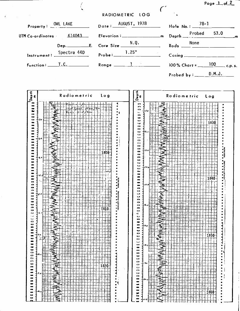
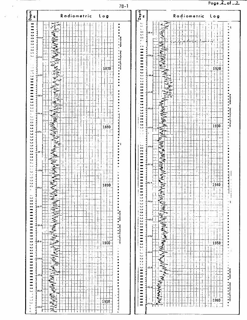
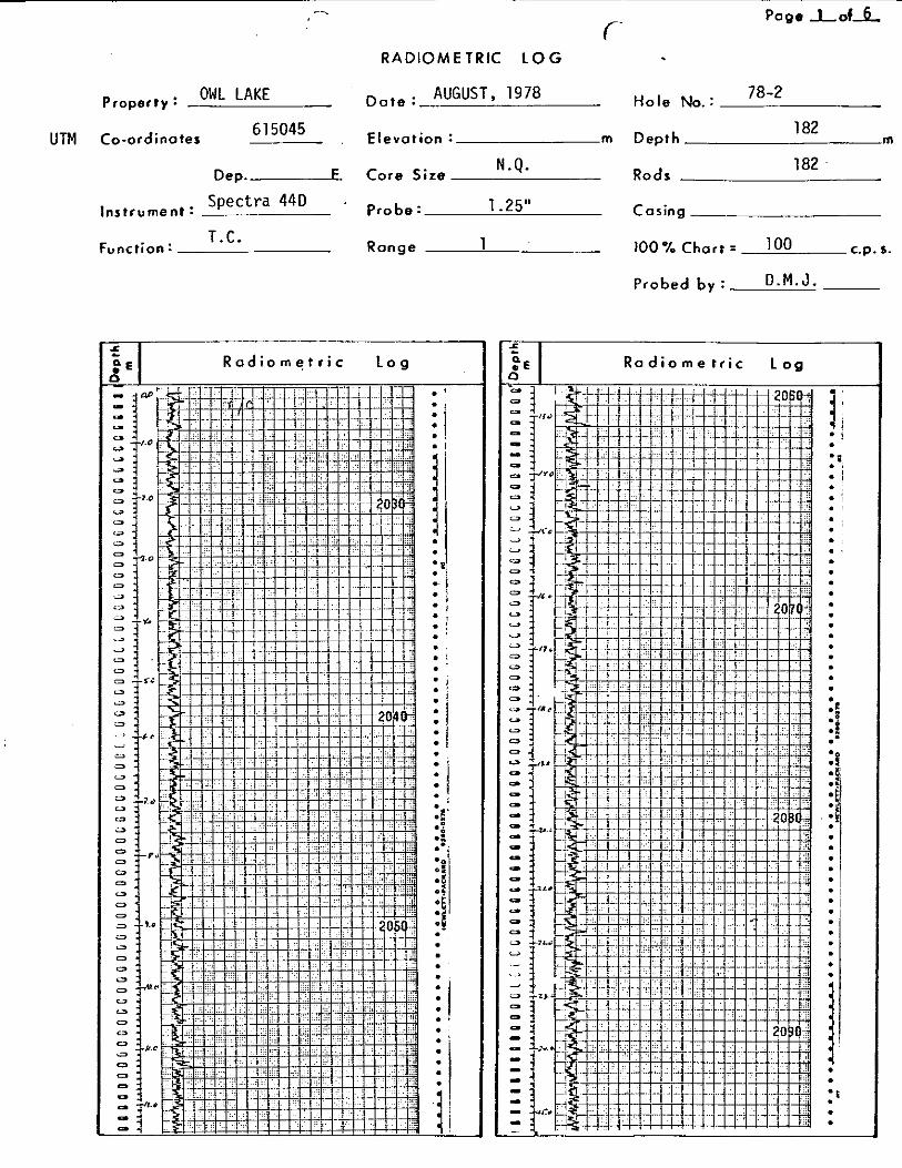
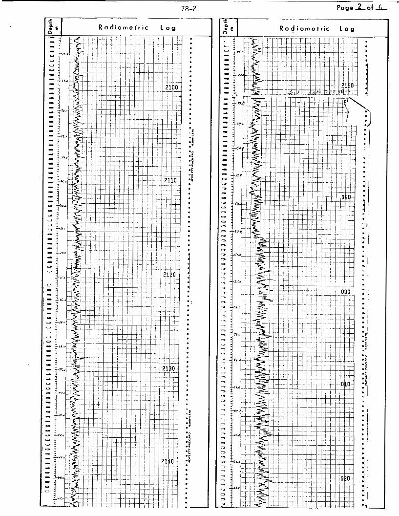
with a McPhar T V l A s c i n t i l l o m e t e r , t h e t o t a l l eng th of a l l d r i l l ho le s
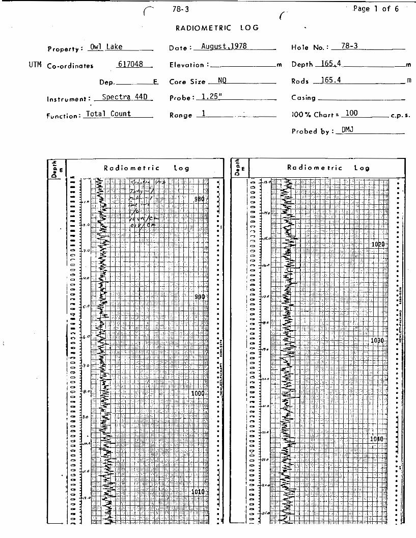
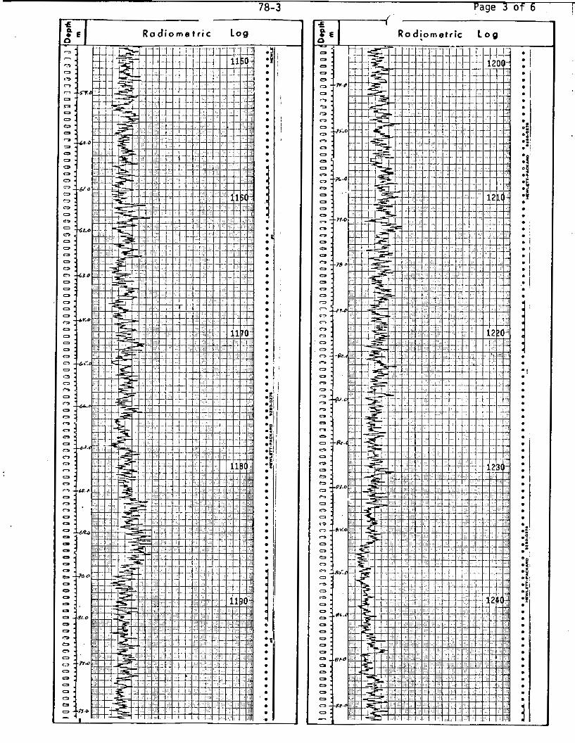
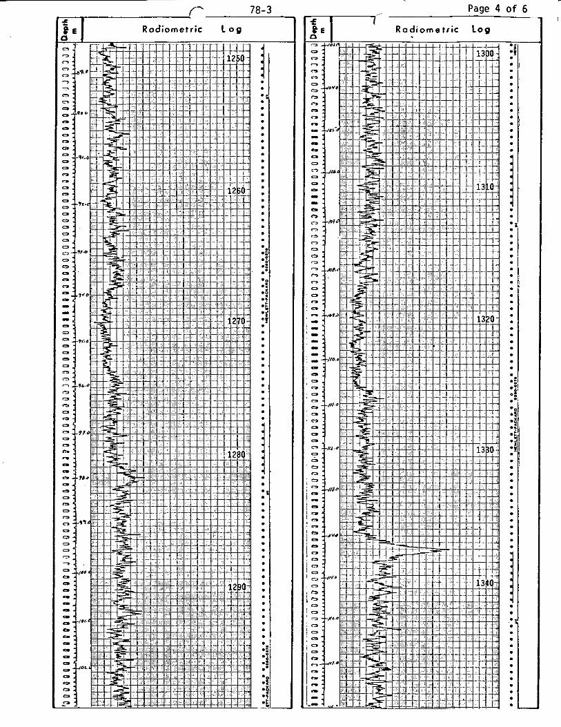
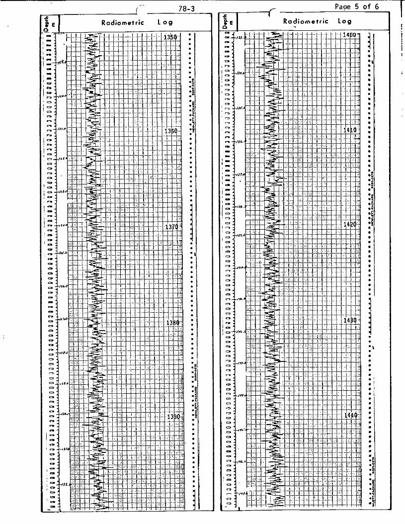
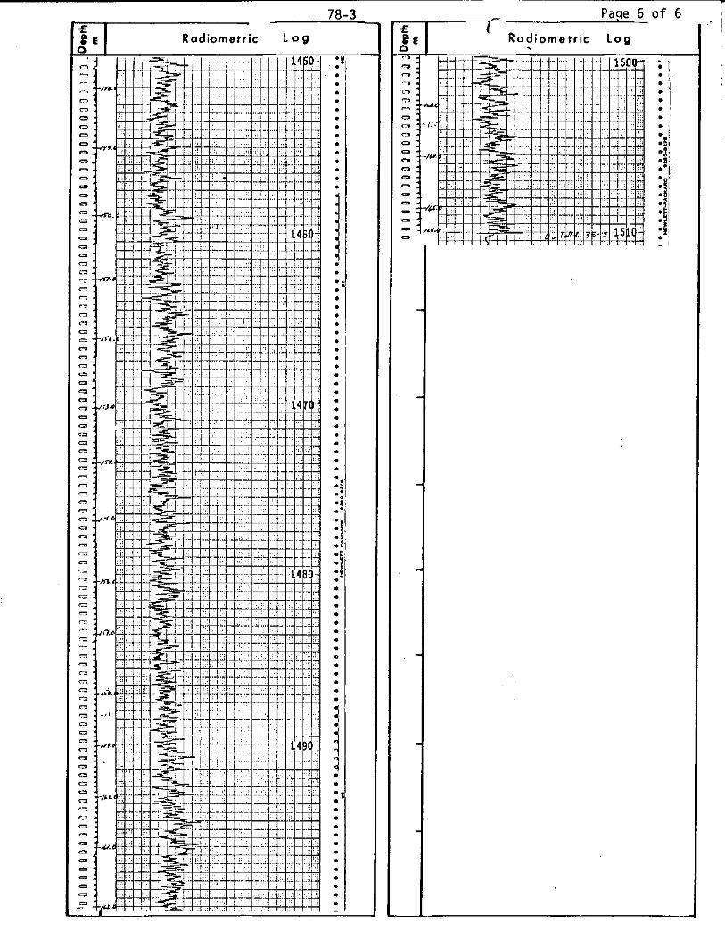
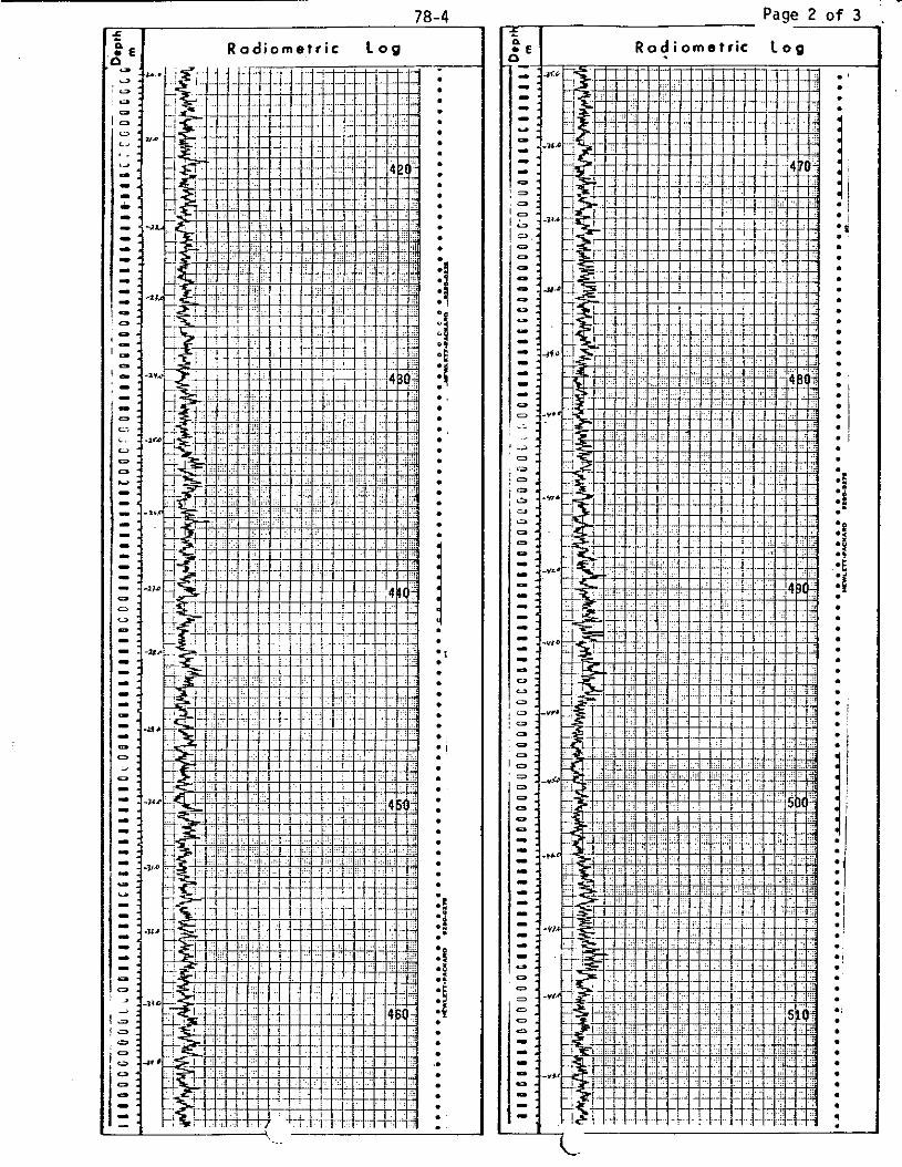
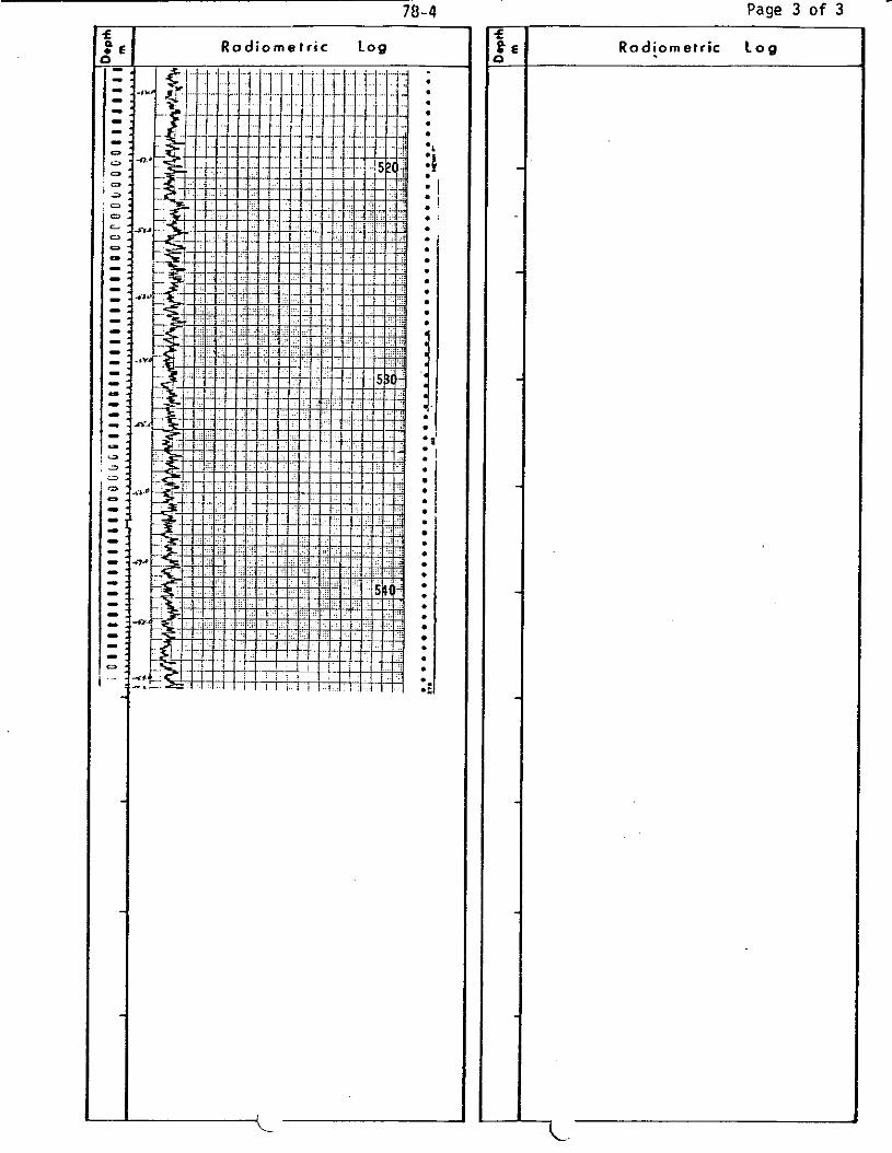
were probed with a McPhar Spectra 44 sc in t i l l ome te r . N o s i g n i f i c a n t
radiometr ic anomalies w e r e encountered. The h ighes t peak on t h e probe
.... 22
700 Burrard Building / 1030 Weest Georgia Street / Vancouva: B C , Canadai V6E 3A8 (604) 682 7082 / Telex 04-55181
- 2 1 -
t r a c e s i s approximately twice background and above background f o r a
length of more or less 0.4 m. This occurs a t a depth of 114.3 m i n
hole 78-3. A chemical a n a l y s i s of t h i s i n t e r v a l i nd ica t ed a uran-
i u m conten t of 3.3 ppm. This U content i s wi th in t h e geochemical
background as determined by chemical a n a l y s i s .
Faul ted brecc ia ted and/or hydrothermally a l t e r e d zones w e r e
sampled i n each d r i l l hole. Most of t h e samples w e r e analyzed f o r
t h e fol lowing elements: U , Cu, M o , Pb, Zn, Ag, Au and W. The
ana lyses are recorded on t h e d r i l l hole sec t ions .
t i o n s t h e s e elements do not occur i n t h e d r i l l ho le s a t economically
s i g n i f i c a n t l e v e l s . A uranium a n a l y s i s of 25 ppm w a s found i n t h e ,
i n t e r v a l 65.5 m t o 66.6 m i n d r i l l ho le 78-2. Because t h i s w a s not
seen i n t h e s c i n t i l l o m e t e r t r a c e t h e sample w a s re-analyzed and a
uranium content of 23 p p m w a s obtained i n t h e second ana lys i s . There-
f o r e s t rong d isequi l ibr ium i s ind ica t ed f o r t h e uranium i n t h i s f rac-
t u r e zone. This d i sequi l ibr ium may be considered evidence of uranium
t r a n s p o r t a t i o n by t h e l o c a l groundwater system i n r e c e n t t imes.
With t w o excep-
Gold was presen t i n one sample a t t h e 1.98 p p m l e v e l i n an
i n t e n s e l y s i l i c i f i e d zone ad jacent t o a f a u l t i n ho le 78-1. The
i n t e r v a l i s 1 .3 meters wide from 35.3 t o 36.6 m i n depth.
Molybdenum does occur i n "porphyry" type mine ra l i za t ion i n t h e
a l a s k i t e southwest of O w l Lake. Twelve d r i l l ho le s were d r i l l e d
during t h e explora t ion of t h i s depos i t by United Buffadison Mines
Limited. These cores w e r e logged by P l a c e r ' s g e o l o g i s t s and
.... 23
700 Burrard Building / 1030 West Georgia Street/Vancouver B C. Canada/ V6E 3A8 (604) 682-7082/ Telm 04-55181
- 22 -
analyses of t h e samples were made on P l a c e r ' s account i n 1965.
The h ighes t MoS2 content repor ted f o r assays of t h e co re i s 0.20%
f o r a width of 10 f e e t . The average grade is very l o w and was not
ca l cu la t ed as t h e h ighes t average grade f o r any d r i l l hole i s 0.04%
MoS A f u r t h e r tes tament t o t h e low grade i s t h a t o n l y t w o core
samples from a populat ion of 260 samples contained more than 0.10%
MoS2.
2 '
D. M. J e n k 4 s SENIOR GEOLOGIST
700 Burrard Building 11030 Weest Georgia Streell Vancouvet; B. C , Canada/V6E 3A8 (604) 682-7082/ Telex 04.55181
- 23 -
STATEMGNT OF QUALIFICATIONS
I , D. M. Jenkins , with business address a t 700 Burrard
Building, Vancouver, B. C., V6E-3A8, do hereby c e r t i f y t h a t I have
supervised t h e f i e l d work and have assessed and i n t e r p r e t e d t h e
d a t a r e s u l t i n g from t h i s work on t h e Loon 1 t o Loon 4 claims.
I also c e r t i f y t h a t :-
1.
2.
3.
4.
5.
I a m a graduate of t h e Universi ty of South F lo r ida ( B . A . Geology, 1963).
I a m a graduate of t h e Universi ty of F lo r ida (M.S. Geology, 1966).
I w a s a graduate s tudent a t t h e Univers i ty of C inc inna t i from 1966 t o 1970.
I have engaged i n mineral explora t ion s i n c e 1970.
I a m a f e l low of t h e Geological Associat ion of Canada.
D. M.S., F.G.A.C. Senior G e o d g i s t
700 Burrard Building / 1030 West Georgia Street/ Vancouvn; B. C., Canada/ V6E 3A8 (604) 682-7082 / T e h 04-55181
A P P E N D I X A
D r i l l Logs and Radiometric Logs
of
1978 D i a m o n d D r i l l H o l e s
The core €or these d r i l l holes i s stored a t Endako m i n e
700 Burrard Building / 1030 T e s t Georgia Street / Vancouver; B C, Canada/ V6E 3A8 (604) 682-7082 / Te1e.z 04-55181
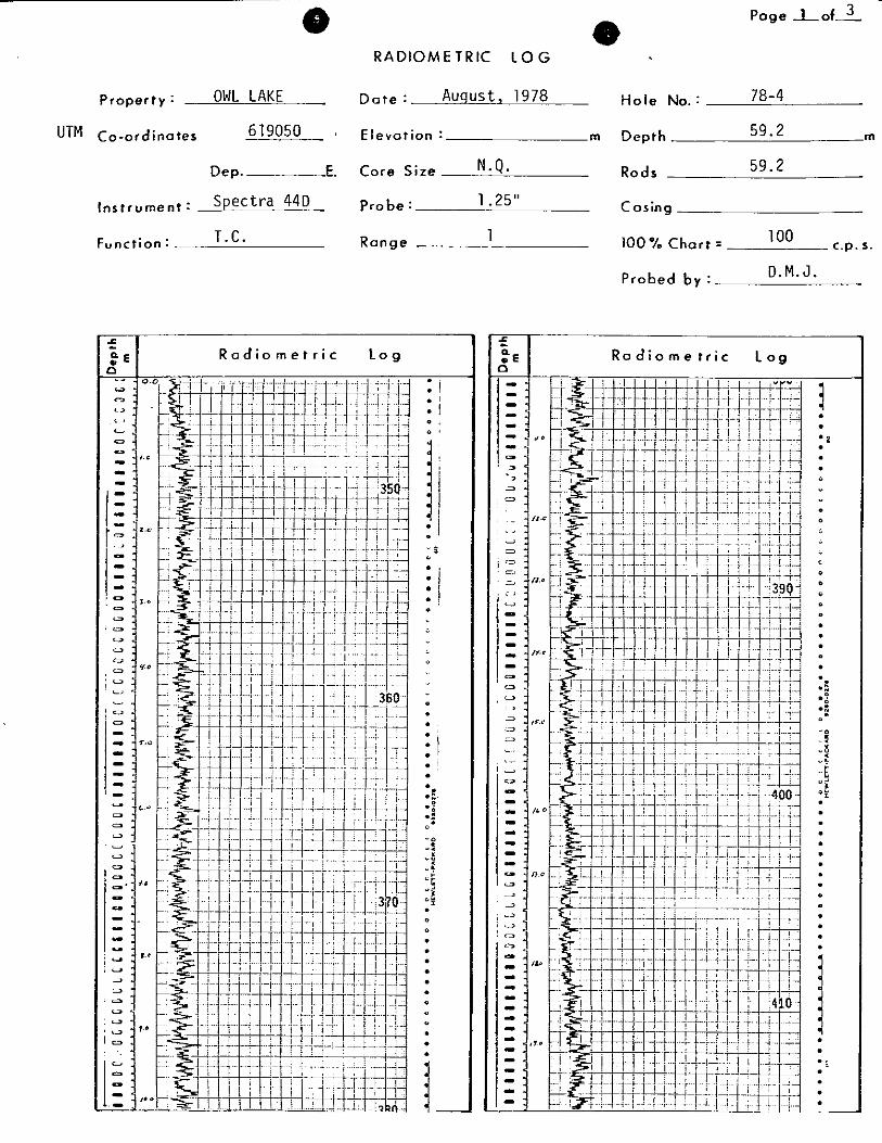
OWL LAKE Property:
UTM Co-ordinates .
Dep. E.
Spectra 440 Instrument:
Function: T.C.
RADIOMETRIC LOG
AUGUST, 1978 D a t e :
Elevation: m
Core Size
Pro be :
N.Q.
1.25"
Range 1 '.
R a d i o m e t r i c L o g
i 0
0
0 "
0
0
0
0
0
0 . 8 .: 0 1 ~i .'I 0
0
0
0
0
0
0
0
. o 0 . .f .: 0.
0 0
.!: 0 5
u$
0 8
."& u u 0
0
0
0
0
0
0
0
4 0
0
0
0
0 -1 * .
0 ,
O a 0 '
0
0
0
0
0
0 '-
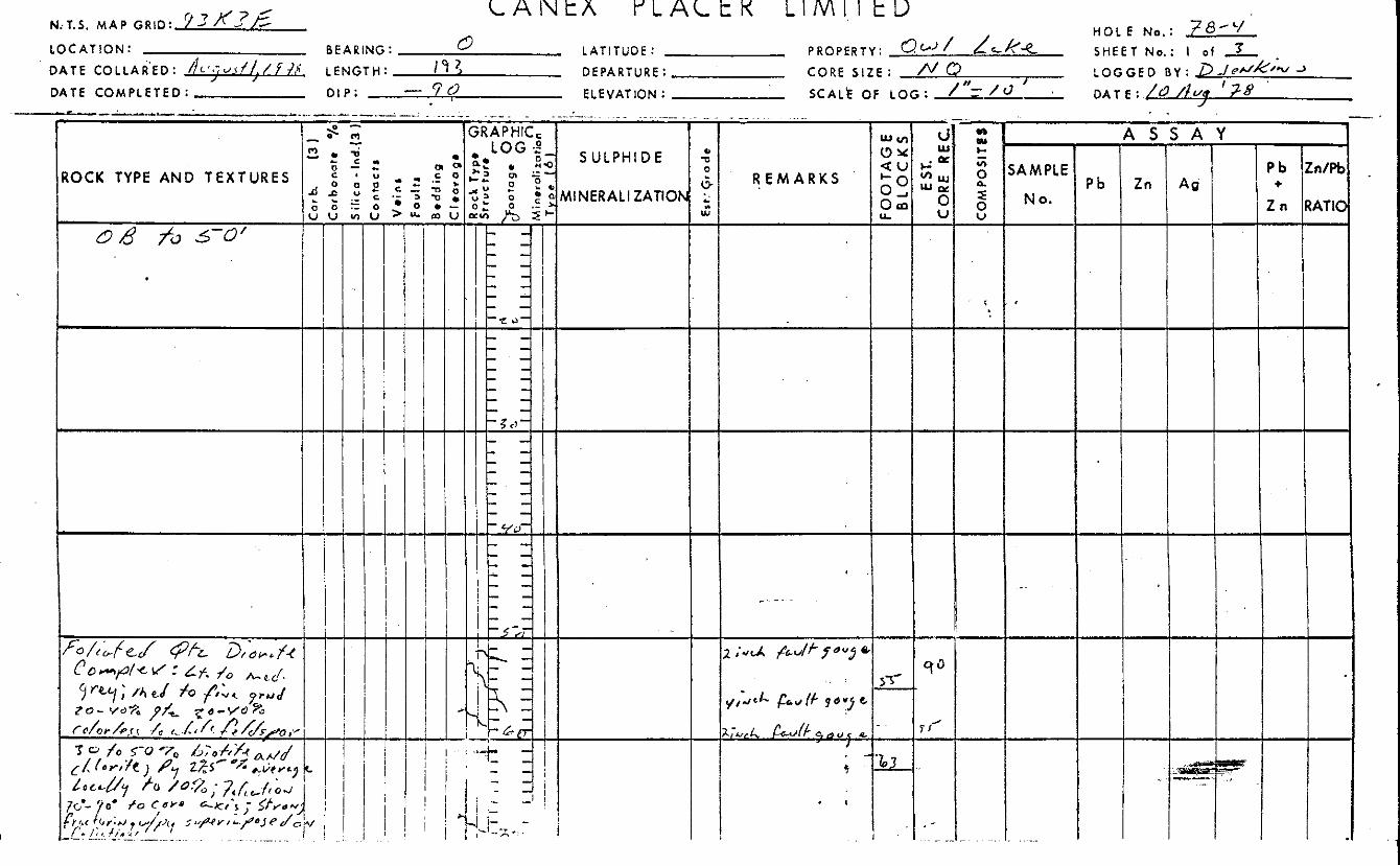
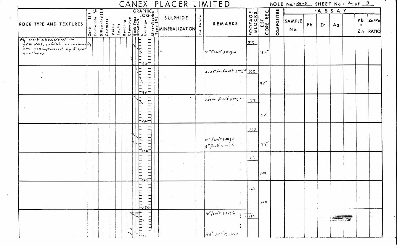
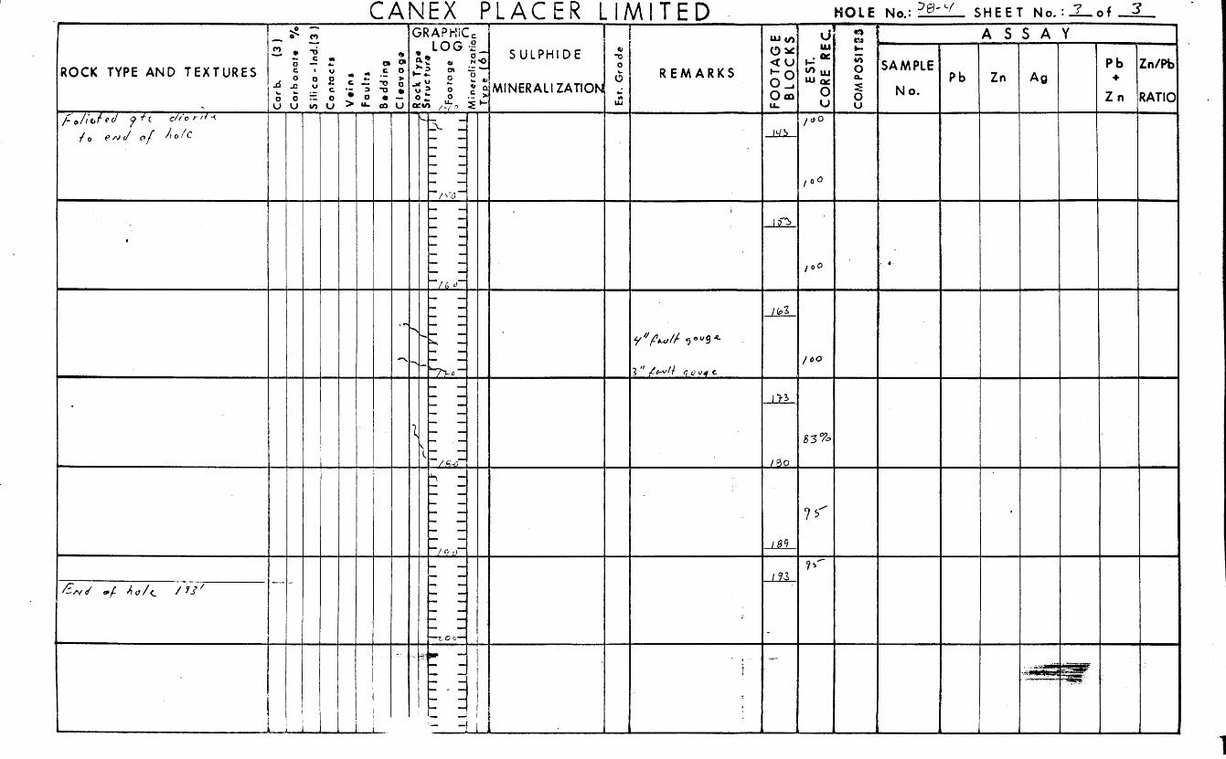
78-1 Hole No.:
Depth
Rods
m Probed 53.0
None
Casing
100 Chart = w o c.p.r.
Probed b y : D. M.,J.
5 OQE R o d i o m e t r i c L o g
L3
0
0 . 0
0
0
0 . 0
0
0
0
6 8 0
c,
0.
0 0
0 2 0 5
0 2
O Y
. I
0
. I 0 1
0
0
0 . 0
0
0
1
0
0 '
0
0
0
0
0
0
0
0 -
.f OOE f3
*.
c:
- c " N
6 %
c.
b 0
u < X b V
O $
O L O J
0
0
0
0
*':
1 0
0
L.
0
0
0
0
0
*. *6
* a
* O
0 :
04.
- %
o u
:! W
- 1
0
0
d 0
U
U
c.
L
U
R a d i o m e t r i c I o g
Page L o f 3
R a d i o m e t r i c L o g - -
c c y
0
0
0
0
0
u 0
e 0
0
0
0
G
0
L,
u 0
0
0
ot
0 :
0 0 m t
0:
0
m u
* 4 *L * J O W
0
L
u 0
0
c,
0
$ 1 11 -!2
0
--.. f Page t o f l
RADIOMETRIC LOG . 78-2
Hole No. : AUGUST, 1978 Property : OWL LAKE D a t e :
UTM Co-ordina ter 6 15045 Elevot ion: m m 182
Depth
182. Rods
N.Q. Dep. E. Core S i z e
Instrument: Spectra 44D . Probe : 1.25" C osing
c.p. 5 . Range 1 100% Chart = 100 T.C. Function :
Probed b y : D.M.J.
.f R o d i o m e t r i c L o g :€
- 0
li O f
: i 0 1
0 '
0 ,
o f
1 0
0 1
0 ,
0
0
0
0
0
0
0
0
0
0
0
0
0
0
.E *a 0:
0.
0
0
0
0
0
0
0
0
0
0
0
0
0
0
0
0
0
0
0
0
0
# 0
0
0
0
0
0
0
.fi
8
78-2
f 2 € R a d i o m e t r i c L o g n
Page - 2 o f -€i
g-- R a d i o m e t r i c L o g
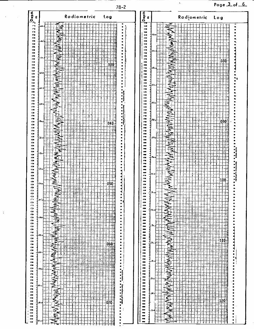
78-2 Page 3 o f 6
R a d i o m e t r i c l o g
- a
Q
4 1 Q - * Q
a
e a Q
a
* * a:
*%
* e
4 a-
m i .a
:i :i * Q
0
e e
0
0
0
'1 i * I
a
78-2
Radiometric 1 o g
Page 4 of
- q f
0
.. ,o 0
0
m 0
0
e '0
0
0
!i io 30
la '0
I:
2-8L !
-2 t
Page 6 or 6
Rpdiometr ic Log
* .
I
Property: owl Lake UTM Co-ordinates 6 17048
Dep. E.
I n s t r u m e n t : Spectra 440
F ~ ~ ~ ~ ; ~ ~ : Total Count
.Page 1 o f 6 f -
78- 3
RADIOME TRlC LO G
D a t e : Auqust91978
Elevation : rn
Core S i r e NO
Probe: 1.25"
Range 1
.
Hole No.: 78-3
Depth 165. 4 m
Ro d s 165 - 4 m
Casing
100% Chart = 100 c.p. s.
Probed b y : DMJ
~
R a d i o m e t r i c l o g
j 0
0 0
0
0
0
0
0
0
0
0
0
0
0
0
0
0
0
0
0
0
0
0
0
01 0
0
0
0
0
0
0
0
e 0
0
0
0
0
0
0
0
0
0
0
0
0
0
0 1 0
X I 1 R a d i o m e t r i c l o g

70-3 - m
I
Page 2 o f 6 &. -
R a d i o m e t r i c L o g .
0
0
0
0
0
0
0
0
0
0
0
0
0
0
0
0
0
* I
01
* ' 01 o!
0 :
*I
.I
.I
.I
0
0
0
0
0
0
0
0
0
0
0
0 1 0
0
0
0
0
0
0
0
0
0
0
0
0
0
0
a a a a
a a
a a a a a
-
- n , " E l R a d i o m e t r i c Log
- I
mi *!
0
0
0
0
. . 0
0
. . 0
0
0
0
. 0
0
.
1 0
0
0
0
. -
Page 4 o f 6
- a a a a a a
a a a a a a a a a
0
I I I
I I I I a a a a a a a a a a a a
a a a a a a a a a a a a a
0
0
0
a
a 0
a a a a a a a a a a a a a a a a a a 4
4
4
a
a a a a a a a a a a a a a a
I
0
0
Page 5 o f 6
611' Rodiometr ic Log
0
0
j * f
0
* '
*P
*:: *. *8
ia :i
U
.- L c
Q
0
'p
0
QL
E .-
I
UI
W*C
I 1
I 1
I I
I
RADIOMETRIC LOG
Page L o f - 3
Proper ty : OWL LAKE
UTM Co-ordinates 619050
Dep. E.
Instrument: Spectra 44D
T.C. Function:
E levat ion: m
Core Size N.Q.
Pro be : 1 .25”
Range 1
R a d i o m e t r i c Log
78-4 Hole No.:
Depth 59.2 m
Rods
Casing
59.2
c.p. 3. 100 100 OI0 Chart =
D.M.J. Probed b y :
5 :E R a d i o m e t r i c L o g 3
78-4 -
Page 2 o f 3
R a d i o m e t r i c L o g * R a d i o m e t r i c L 0 9
I.
- ~~ ~
Page 3 o f 3 70-4 I
' E l R a d i o m e t r i c Log
a a
a a a
a
$ : j : I a : a a a
a a a a a .I. a a
a a a a
a a a a a a a a a
a a a
*.
R a d i o m e t r i c l o g
,
I.
(-
RADIOMETRIC LOG *
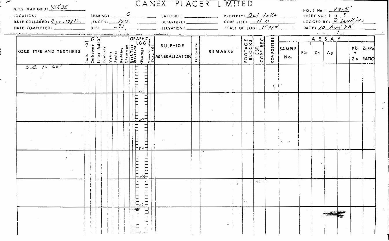
Property: Owl Lake D a t e : August, 1978 Hole No.: 78-5
UTM Co-ordinates 620055 Elevation : m Depth 55.2 m
55.2 Rods N . Q . Dep. E. Core S i r e
Instrument: Spectra 44D Pro be : 1.25" Casing
Function: T .C . Range 1 100 c.p. 3. 100% Chart =
D.M. J. Probed b y :
f R a d i o m e t r i c L o g
I - -
r 78-5 f
R a d i o m e t r i c L o g
0
e L
* I
* I
* I
*
I *
9
/ 0
0
0
0
* a *: S:
*!
0 :
4
mj
* I
* I
mj CII
c
L
0
0
-
b I ' 78-5 f
P . o E R a d i o m e t r i c Log
,F Page 3 o f 3
R a d i o m e t r i c L o g
APPENDIX B
Statement of Costs
700 Burrurd Building / 1030 West Georgia Street / Vancouver; B. C, Cunadal V6E 3A8 (604) 682-7082 / Telex 04-55181
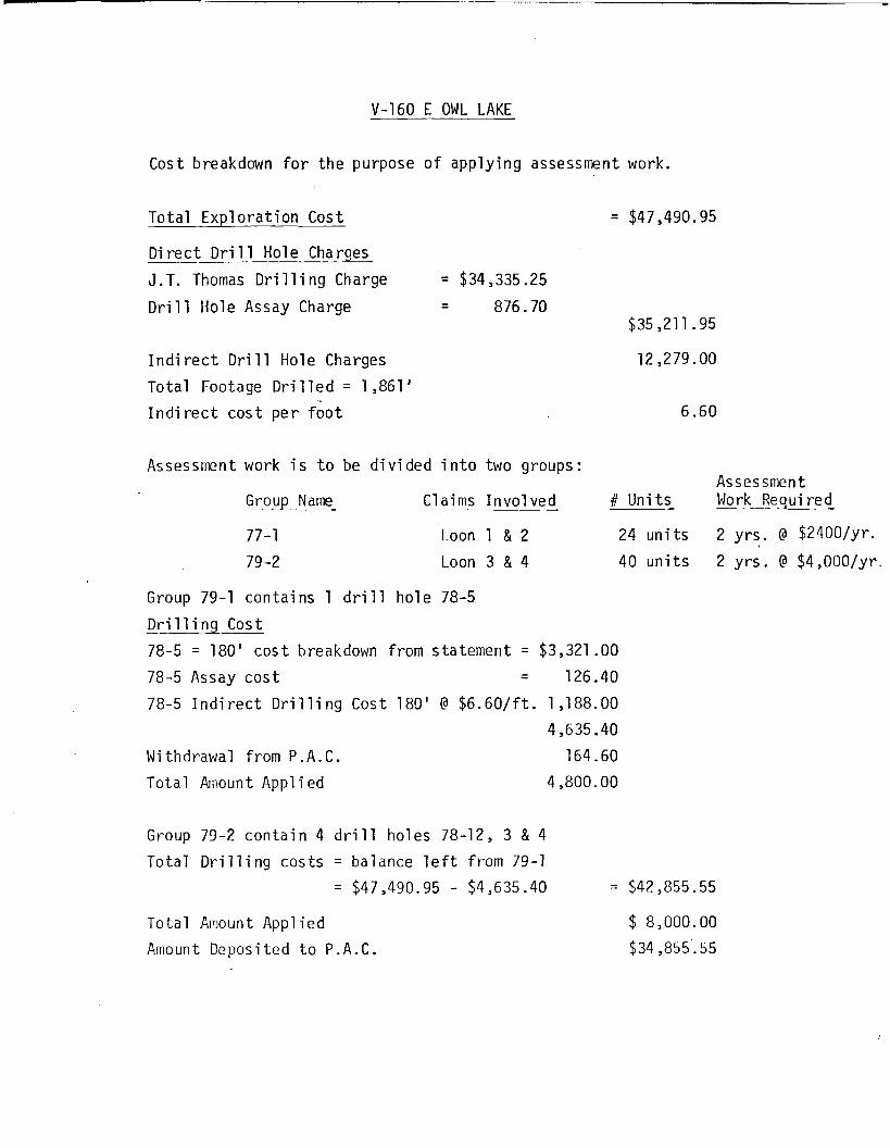
V-160 E OWL LAKE
Cost breakdown f o r the purpose of applying assessment work.
Total Explorat ion Cost
Direct Drill Hole Charges J . T. Thomas Dri 11 i ng Charge = $34,335.25
876.70 - Drill Hole Assay Charge -
Indi rect Dri 11 Hole Charges Total Footage D r i l l e d = 1,861' I n d i r e c t c o s t per f o o t
Assessment work i s t o be divided i n t o two groups:
Group Name C1 aims Involved
77-1 Loon 1 & 2 79 -2 Loon 3 & 4
= $47,490.95
$35,211.95
12,279.00
6.60
Asses smen t
2 y r s . Q $2400/Yr- 2 y r s . Q $4,00O/yr.
# Units Work Required
24 units 40 units
Group 79-1 conta ins 1 d r i l l ho le 78-5 D r i l l i n g Cost 78-5 = 180' c o s t breakdown from s ta tement = $3,321.00 78-5 Assay c o s t = 126.40
78-5 I n d i r e c t D r i l l i n g Cost 189' Q $6 .60 / f t . 1,188.00 4,635.40
Withdrawal from P . A . C . 164.60 Total Amount A p p l i e d 4,800.00
Group 79-2 con ta in 4 d r i l l ho les 78-12, 3 & 4 Total D r i l l i n g c o s t s = balance l e f t from 79-1
= $47,490.95 - $4,635.40 = $42,855.55
Total Amount Applied Amount Deposited t o P . A . C .
$ 8,000.00 $34,855.. 55
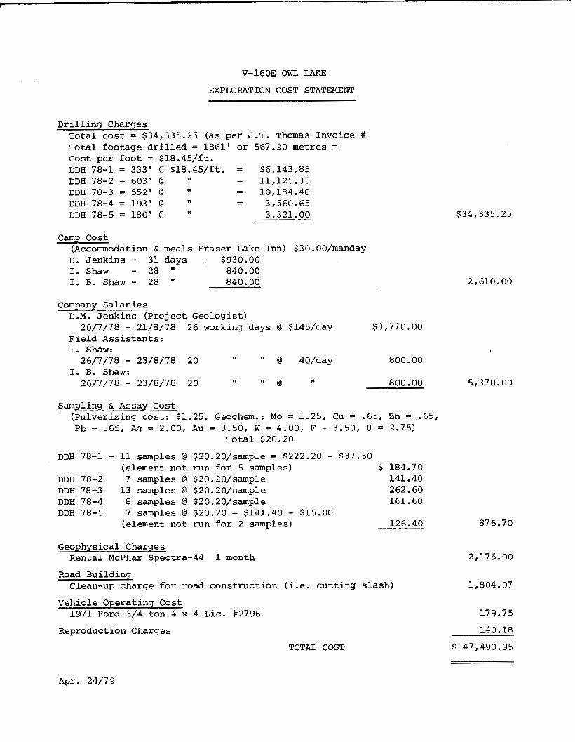
V-16OE OWL LAKE
EXPLORATION COST STATEMENT
D r i l l i n g Charges Total cost = $34,335.25 (as per J .T . Thomas Invoice Total footage d r i l l e d = 1861' or 567.20 metres = cost per foot = $18.45/ft .
DDH 78-2 = 603' @ = 11,125.35 II = 10,184.40
3,560.65 DDH 78-4 = 193' @ - DDH 78-5 = 180' @ 3,321.00
DDH 78-1 = 333' @ $18.45/ft . = $6,143.85
DDH 78-3 = 552' @
II
- 11
camp cost (Accommodation & meals F r a s e r Lake Inn) $30.00/manday
D. J e n k i n s - 31 days $930.00 I. Shaw - 28 I' 840.00 I. B. Shaw - 28 I' 840.00
#
$34,335.25
company S a l a r i e s D.M. J e n k i n s ( P r o j e c t G e o l o g i s t )
F i e l d Ass i s t an t s : I. Shaw:
I. B. Shdw:
20/7/78 - 21/8/78 26 working days @ $145/day $3,770.00
11 26/7/78 - 23/8/78 20 I' @ 40/day 800.00
26/7/78 - 23/8/78 20 @ 800.00 II 11
Sampling & Assay C o s t ( P u l v e r i z i n g cost: $1.25, Geochem.: MO = 1.25, Cu = .65, Zn = .65, Pb - .65, Ag = 2.00, A u = 3.50, W = 4.00, F - 3.50, U = 2.75)
Total $20.20
DDH 78-1 - 11 samples @ $20.20/sample = $222.20 - $37.50 (element not r u n for 5 samples) $ 184.70
141.40 DDH 78-2 7 Samples @ $20.20/Sample DDH 78-3 1 3 samples @ $20.20/sample 262.60
161.60 DDH 78-4 8 samples @ $20.20/sample DDH 78-5 7 Samples @ $20.20 = $141.40 - $15.00
126.40 (element n o t run for 2 samples)
Geophysical Charges
Road B u i l d i n g
V e h i c l e Operating C o s t
Reproduct ion Charges
R e n t a l McPhar Spectra-44 1 month
Clean-up c h a r g e fo r road c o n s t r u c t i o n (i.e. c u t t i n g s l a s h )
1971 Ford 3/4 ton 4 x 4 L i c . #2796
2,610.00
5,37 0.00
876.70
2,175.00
1,804.07
179.75
140.18
$ 47,490.95 TOTAL COST
A p r . 24/79
W 0
n
X +
.(
W
m
b z 0
+
m
x
-4 c
W
rn
v)
P
?
:orb
(3
) :o
rboR
Ot.
"A
; i
lic
o - l
nd.(
3 '0
n ta
c t s
Ve
ins
Fa
ult
,
3e
dd
ing
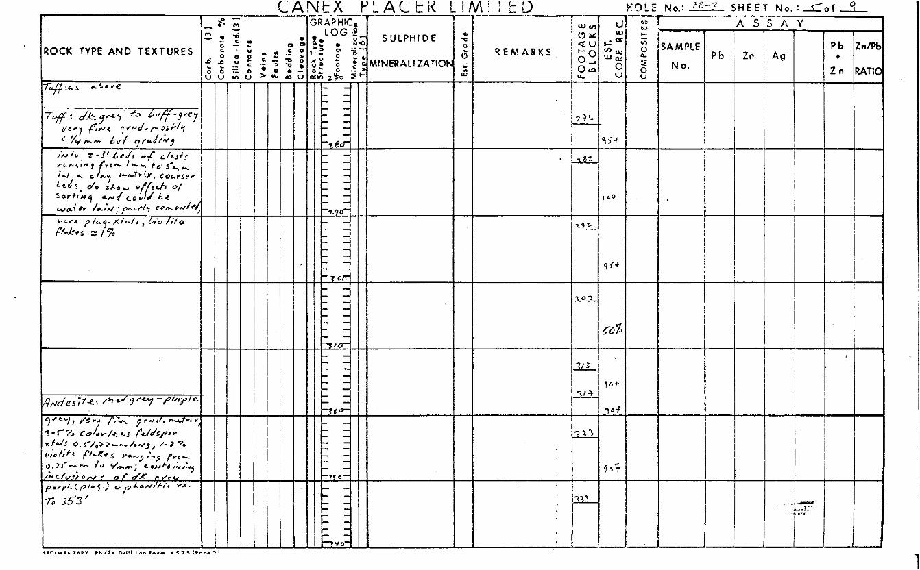
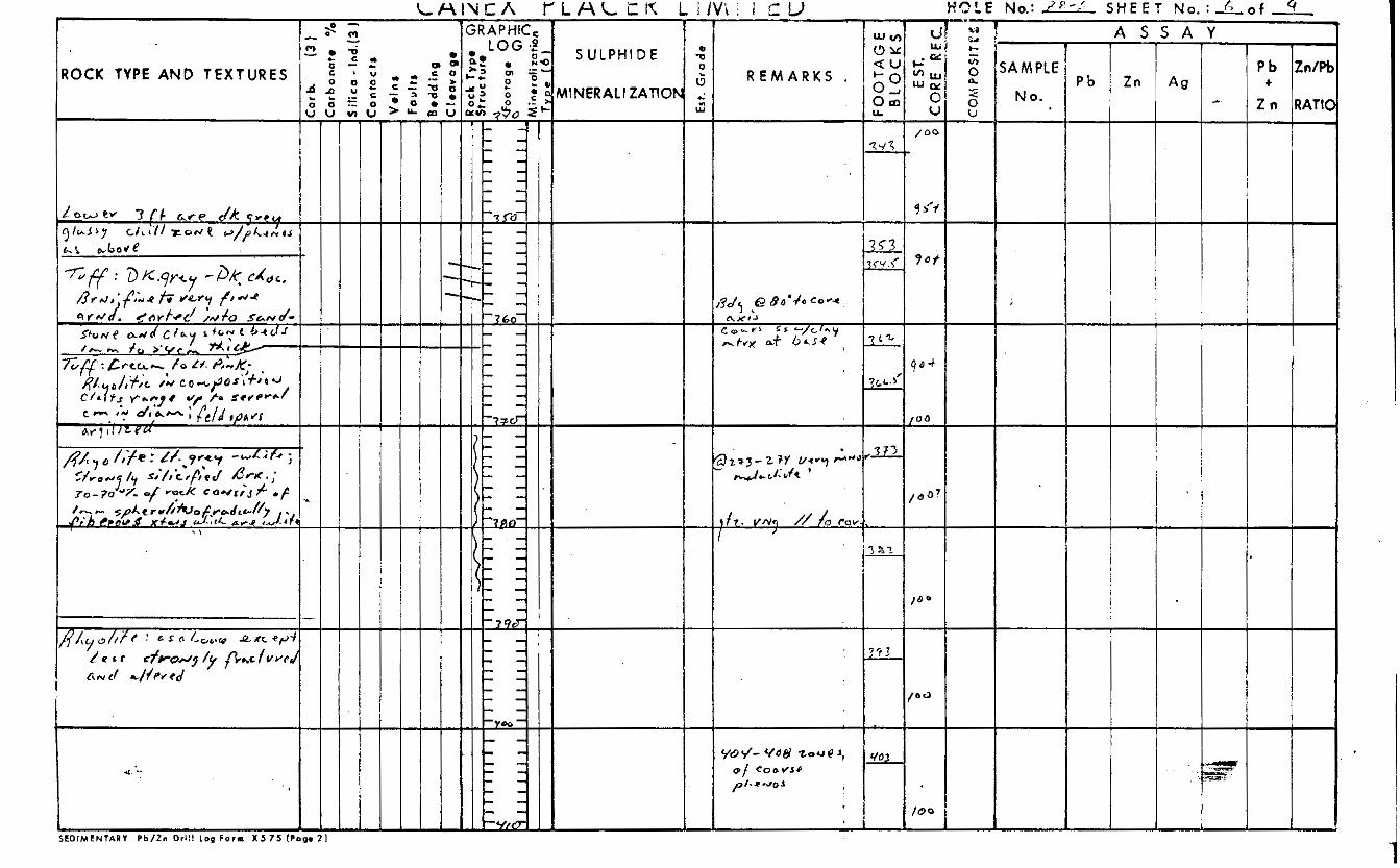
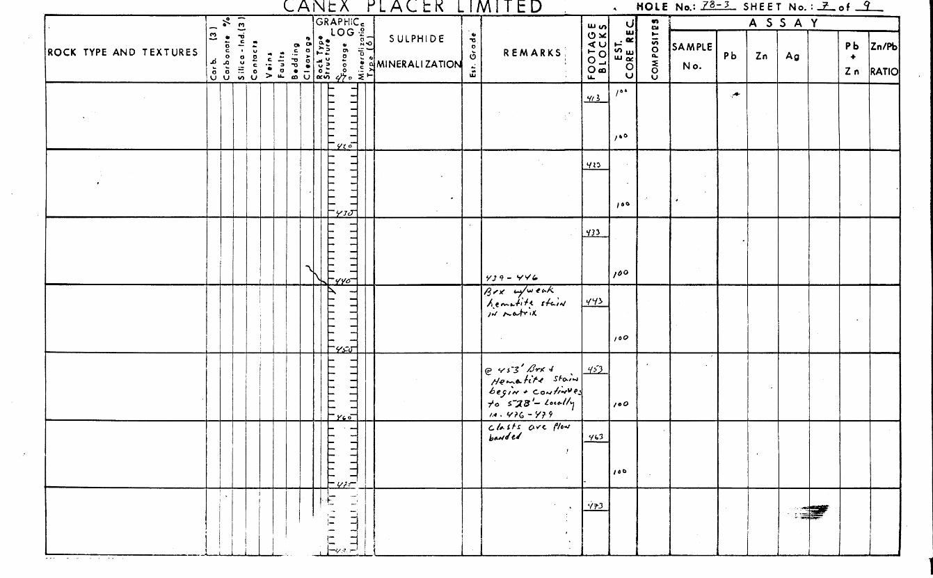
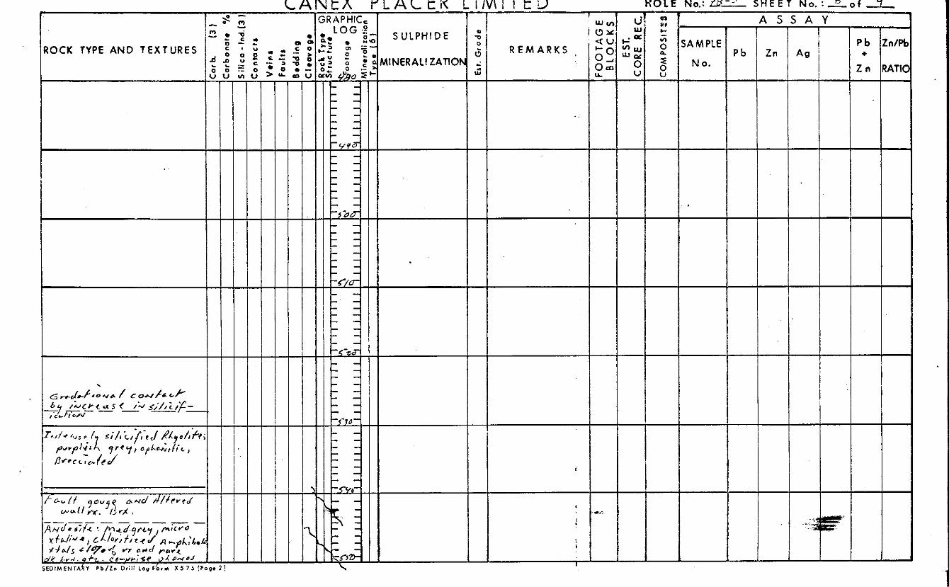
.. 3 ?ock T
yp
o G:
5tru
ctu
ro
x lllllllIS
I r >
0 L
3 f-
Est
. G
rad
e --_I__-
r ! c e 2
rl
4 I
c ? i
c 'i s
- -- I
FO
OT
AG
E
BL
OC
KS
E Sl.
CO
RE
R
EC
,
_.---
-----.
\
U
m \
2
..*
--.-
-- -
I
0
r- m
Z
0 ..
0 - 4
N
3
.
S R A P H IC - !n/Pt
1ATIC
I In I A g
1 I = t P b
Z n
+ /ROCK TYPE AND T E X T U R E S Id d MINERAL! ZATlOh * --
m u I
I
i
I
I '
+ 1 I
SEDIMENTARY P b / Z n Dri l l l o g F o r m X 5 7 5 (Page 2 I
'0 N
31d W VS snavw31i
0311W11 tl33Vld X3NV3
8 2 I
m
b z 0
-I
rn
x I
c
W
m
v,
:orb
. (3
) :o
rbo
rro
te
9 i i
lico
- lnd.
(3
:o n
toc
ts
Yo
ins
Fau
lts
bodd
ing
: I .or
0 g
o
lock
Typ
o
it ru
e tu
re
$ d
11-1
1 I
I I
I r
L 111111111
I
111111111
Est.
Gro
.de
I0
m 3
b
A
r;
v,
F O
OT
AG
E
BL
OC
KS
E
ST.
:OR
E R
EC.
I
42
0
bD
0
I O
M P
OS
lTlll
l
in
W
W
.
Y I IE -
8. 0
0 A n
Pb Zn/H
Z n RAW + ROCK TYPE AND T E X T U R E S R E M A R K S
w u I
-I- I
S E D I M E N T A R Y P b / Z n Dri l l Lop F o r m X 5 7 5 (Page
HOL E No.: ?@- L O C A T I O N : BEARING : 1 AT1 TUDE : P R O P E S T Y : 0 w i SHEET No.: 1 of ,-. 4 c9
GRAPHIC, I Y ULPH
'ERALt
I D €
ZATION
P b
Z n
+ !n/Pb
IATIO
ROCK TYPE AND T E X T U R E S
I
I
c1 n 3 2 > a 5 n
1
\ a F a C 9 r 0 a
1
1
0 I > tJ tJ \
c 1 n 0
h - h
;o 0
n
x +
4
Q
m
B z 0
-4
m
X +
C
W
m
v)
---- So
rb
(3)
Car
bon
ate
5 ili
ca
- ln
d.(
3 ~
20 n
toc
ts
Ve
ins
F
au
lt,
3ed
din
g Z Ieov 0
98
Ro
ck Typo
0
Str
uc
ture
ZJ
T
.m
111111111
!! n
m
J !
J.
LU
hi. Gr
a d
e
' --
..
.
x)
rn
3
b
70
x
v)
0 r-
FO
O T
P. 5
E
BL
O(
'S
E ST.
C
OR
E
Rh
.
I_--
U
W
N
3
.
n 17
A I t =31HdY
nw
_-
I
08
L
io 6 t--I
n 0 3: 0 !!?
-m
-@
n 3
oz 3;
a0 JOUVZ 17VWNIW
301Hdln S s)Iww311 S3tlfllX31 ONV 3dA.A X30a
AVSSV
- --
W 0
-
n
x
:arb
. (3
) :a
rbor
rote
7
5 ifi
ca
- lnd
.(3
50
CIt
UC
t)
V8
inS
Fa
ult
,
3od
din
g =
I ea
va
qe
311111111
511111111
J
W
m 3
B
A
;rc
tn
FO
OT
AG
E
BL
OC
KS
-1
E ST
. C
OR
E
RE
C
-c t 0
:OM
PO SI f
C f
“I
~-
W
,
0'
n
x
c
- - _-
C
orb
. (3
) :a
rbo
na
t8
"/1 5 i
fic
a - l
nd.1
3 :a
n
tac
tg
I
Ve
in6
Fa
ult
,
3e
dd
ing
Est. G
rod
e
W
m 3
B
;;o
x
v)
I_
FO
OT
AG
E
BL
OC
YS
E ST
. C
OR
E 6
;Trf
-.
.-.
..
A __
W
Cl
I- -1
- \ 0
0
3 G
0
... L,.
ROCK TYPE AND T E X T U R E S
I I f L U * { ' -
SEDIMENTARY P b / Z n D r i l l l o g F o r m X 5 7 5 (Pago 2 * , . . , . . . ,.. I..... :. .... . . ) ,
ROCK TYPE AND T E X T U R E S
/- 'I
L L
0 0 v u
s-0 3
S A
A s
Y
Pb Zn/Qt
2 n RATIC +
k ., 1 6 2 o
ROCK TYPE AND T E X T U R ' E S i ; id 9
I
c3 Y
5RAPtitlC. f S ULPHl D E
MlNERALl ZATlON
i ! !
M O L E No.:= S H E E T N o . : L o f .I Q - C " 1 . 7 A s s A Y
F F O I M F N T A R Y P b / Z n Dri l l I o n F n r n X 5 7 5 ! P r , n r 71
. c/c ’ 78 1 ELEVATION : , S C A L E OF L O G : k/”=/o’- DATE:.^ 4 DATE COMPLETED: D I P ; - 9 0
SRAPHIC, I 1 A S S A Y 1 P b
Z n
+ !n/%
LATIO
R E M A R K S SAM P I E
N 0 .
ROCK TYPE AND T E X T U R E S r ) - c t
0- a @ u > u ,
t - 1
i - - 1
I
.. .. ”
’3lH dV89
L A N k K Y L A L t K I A S S A Y 3RAPHIC, 1 (3
Y
S U L P H
NERALI
I D €
ZATION
- Zn I 3 .
c 0
. * e S A M P L E
N 0 .
ROCK TYPE AND T E X T U R E S R E M A R K S P b I
I33
19i+(
: I'
SEDIMENTARY P b / Z n Dri l l Log F o r m X 5 7 5 (Pogo
a 5
-
5: 0.
+
m
X
I c
W
m
v,
0 t
torb
. (3
) Z
arb
orr
ate
*/
5 ili
co
- lnd
.(3
hn
mc
ts
11
11
11
11
1
I
Esr.
Gra
de
p I-
-_
_I
FO
OT
AG
E
__I--
BL
OC
KS
E ST
. C
OR
E
RE
C
--c
--* *
Is 1' 3
I- \ e D
m
0 1'
ROCK TYPE AND T E X T U R E S
I
m Y
I ' I I
S A Y
- .-
Pb Z d P t
2 n RATIC +
I
C F l 3 I M F N T A R Y P h / 7 n Dri l l Inn F o r m Y 5 7 5 f P n n - 3 I
I
.
5OUVZ 17VWNlW
3 0 IHd7n S A
~ Co
rk
(3)
:orb
orro
te
"/
5 ilica -
lnd.
(3
zo
ntoc
ts
x)
m 3
b
x, x
v,
*-
-
(s
FO
OT
AG
E
BL
OC
KS
I
\
b
0
E ST.
C
OR
E
RE
C
c
P
=3
P
w
c
m
C
NW
3 +u
I I- - --'- - --'-- I-
I -- I
4
.
1
i
* 37d W VS I
n 2 :I
' s)lblvw3tl w "Z
n w AVSS-V '3iH dV89

ROCK TYPE A N D T E X T U R E S
1 \
CANEX P L A C E R L IMITED cr) Y @
0 C 0
c
-", u -
* ).
W 0 c 0 U
.L.
- C
0 .- >
I
I
R E M A R K S
HOLE S H E E T N o . : L o f ,A. A S S A Y . I
Pb ZdPI
2 n RATN +
L A N t X P L A L E K L I M I 7 E D H O L E No.: ,=,
3 L A T I T U D E : SHEET N o , : 1 o f ,_.
N;T.S. MAP GRID: YJ f' -'f= L O C A T I O N : BEARING: 0
I SRAPHIC, I -
A S S A Y
5A M PLE
N 0.
4OCK TYPE AND T E X T U R E S R E M A R K S ' Pb 2 n RATIC K
:orb
. (3
) :o
rbon
at*
"/(
5 ili
co
- lnd
.(3
:a n
tac
?I
Ve
ins
F
avlr
r
3e
dd
ing
Z
I oa
va
ge
FO
OT
AG
E
BL
OC
KS
4
E ST.
CO
RE
R
EC
CO
MPO
SiT
8d
I -
i I
-
v) P
=3
P
W
c
m
.
0
u-
! L
! i N
3
1 9
! 1: i
t'
NW
3
+w
FY
W 0
n
x I
-<
'D
m
-I
m
x I
c
x1
m
v,
:arb
(3
) :o
rbo
na
te
"A
iili
co
- Ind
.(3
:
0 n ta
c r
a
Ve
ins
Fa
ult
s
3edd
ing
n * z m
x
W
r
P
m n
iw I
-
3
m
U
-
-i
=IE
0
m
2
0
r- .. V
?
r \
v, I
rn
rn z ? 4 .. I4 0
-+
s
f
I I
I I
I I
pr Es
r. G
rad
e
x)
rn 3
b
A
x
v,
0
C
'1
0
'P
.. .
~ ..
. ..,
. -. I
.b F
OO
TA
GE
B
LO
CK
S~
E S
T.
CO
RE
RE
C
%
0 0
1
6
C
%
0 0
ZOM
PO
SIT
DQ
v, B
=3
P
-0
m
r
W
W
N
3 P
Q
NW
3 +u
C A N E X PLA-C-E-R L I M I T E D HOL E No.: ?@-sll- N.T.S. M A P GRID: /3’c >‘-
LOCATION: BEARING; 0 LATITUDE: PROPERTY: 03 / p - K4 SHEET No.: 1 of ,-, 3 I LOGGED B y : i%J4HX’’3 O A T E C O L L A R ’ E D : u i f.5J r r b LENGTH: / B 0
I ELEVATION : S C A L E OF LOG:,-L: D A T E : . / & f lu? DATE COMPLETED: D I P : -*Fa DEPARTURE: CORf SIZE: A/ Q / I >$’.
3RAPHIC, .c5
t7 u
d c * ‘ U 0 0
.- 0
- L
- .u 2
1
L
i
A S S A Y S ULPHl D E
MINERAL1 ZATlOh
SAMPLE
N 0 .
P b Z d P t
2 n RATIC + ROCK TYPE AND T E X T U R E S P b
+
CANEX P I A C E R L HOLE No.: 7 B - J I ' S H E E T No. : = o f '3, MITED *
A S S A Y Y
d c(. - c
- Pb
Zn +
S ULPHIOE
MINERAL1 ZATIOI
SAM PLE
N 0.
ROCK TYPE AND T E X T U R E S 1: R E M A R K S Pb
It G 2 & 8 ' , ?@
Y
__
. . 88
1 0
r P - -
Co
rb.
(3)
:orb
on
ate
"/(
S il
ico
- lnd
.(3
Zo
nta
c t
6
Ve
in8
Fa u
! ts
Be
dd
ing
tl
eo
vo
pe
.
m
m
J-
Jn
nT
n
. s
'L
UU
U
FO
OT
AG
E
BL
OC
KS
E
ST.
C-O
RE
RE
C
P
I
3
rc)
* d
-*
4'
c v)
B
=s
P
lJ
m
r
N
3
!i
4
NW
3 +u
I --
I 1 .d
FY
Meters Parts Per Million
. . . . 1,161.5 164.1 2.6
. . I . . . . . . . . . . . . . . . .
TOP Bottom Length I MO cu Zn Pb Ag Au W F U I I I 1 I I I 1 I I I I I I I 1 i
D R A W N ' D . J . S C A L E i :soo PLACE,R DEVELOPMENT LIMITED
/$OWL LAKE TRACED:P. K DATE. Oct.30/78
APPROVED: REVISED , . .a
Cross Section Diamond Drill Hole Owl Lake 78-3
FILE REF. No.: 78 -10 - V -160E - 2 B -0004
0 verbu rden
Andesite : crackle brecciation
Andesite : Amygdo loldal
Dacite : Vesicular and I f l o w banded
~ r e ~ c i a ~ i o ~ and - - - - - - quartz velnlng _ _
- - - - _ _ _ - - B recciat ion
A _ _ - - - - - A
- _ _ _ - - - - - - - Brsccjation a n d S I l l lf jca t I o n
Brecciation
- - - -- - _ _ - - -- - --
Lithic T u f f : coarse grained
I
3.9
3.8
3.2
3.2
2.4
3 . 3
4.6
5.4
4.6
05-
2.8
6.2
7.7
33
36
36
39 3.0 I - 12
3.0 I 9 52 12
60 16
0.24
0.29 0.02-
0.02-
5-
5-
5 -
5-
5 -
5-
5-
5-
10
5-
5
5
Jm
I70 II 5
2 20
2 20
2 30
I 7 0
I 7 5
I 0 5
250
155
2 10
240
I 45.7 46 0.3 I - 8 57 12 0.26 0.02-
56.4 58.8 2.4 I. 9 68 II 0. 23 0.02-
r 9 70.6 72 1.4 I I I 58 0.34 0.02-
T u f f : f ine grained
/-I 1 3 . 7 1 1 4 . 6 0.9 r I 1 41 2 0 0.29 0.02- T u f f . f i n e grained I 15.6 I 0
ooo -
T u f f : coarse grained Rhyolite: spherulitic and
- I 16.2 0.6
117.1 0.9 silicified
I 4 38 16
I 3 37 13
2 2 9 193 22
0.19
0.10
0.64
0.02-
0.02 - 0.02- PI I- 117.7 I18 0.3
t: :: :I I------ . . . . . f~n,. . -7" r p - p ' " - , - " c - - - - * . - ' I . . !:!: . . . . . .
A,...... ..-. -4.r l . . . . . . Rhyolite : spherulit ic
- - - . B recc i a ted
weak crackle breccia t ion
- - - - ----
I - 5 25 10 0.16 0.02-
I - 16 92 I I
I 14 83 23
Legend
0.71
0.10
0.02-
0.06 / 164.1 165.8 1 .7
I:.:*I Overburden A ndesi t e
pJ Lithic T u f f or T u f f \ Fault
Bedding Rhyolite \
'. . . *c,
I::::] . . . .
. -.. Andes1 t e
Total Depth 168
F i g u r e
Over burden
~
DRAWN:D. J . S C A L E : 1 :so0 PLACER DEVELOPMENT LIMITED Cross Section Diamond Dril l Hole Owl Lake 78-4 . 4 O W L L A K E TRACED:P K. DATE:Ocr.30/78
Foliated Quartz Diorite
strong shearing and
alteration of
minerals to
Tota l Depth
ferromagnesian
chlor i te .
5 8 . 8 m f
Meters Parts Per Mi l l ion
T O P
15.2 18.3
2 1.3
25.6
37.5
40.5 4 3.6
49.7
Bottom
I 8.3 21.3
2 4.3
28.6
4 0.5
4 3.6 46.6
5 2.7
Length I Mo Cu Zn Pb Ag Au W F U 1 I I I I I 1 I 1 I 1 I I I 1 I 1 I
3. I 3
3
3
3
3.1
3
3
I
I7&U ra .
I 51 57 I 200 58
I 103 600
6 I 5 I
2 79
4 I I 2
4 69
I 0 9
6 0
62
66
64
47
4
I I
620
6
10
20
6
3
Legend
0.21 0.03 0.94 0.02-
I .23 0.02-
0.31 0.2
0.28 0.02
0.34 0.03
0.31 0.02-
0.24 0.05
Over bu rde n
Conglomerate, Lithic Tuf f or T u f f
Rhyolite
Dacite
Andesite
Granite
Foliated Quartz Diorite
Faulr Gouge
Fault
Bedding
F i g u
0.5-
9 180 0.5-
8 180 0.5-
4.0
5 195 0.5-
5 I 95 0.5-
5 2.10 0.5
0.5
I A P P R O V E D : I R E V I S E D : I I F I L E R E F NO.: 78-10-V-160E - 2 B -0005

Top B o t t o m Length
Overburden
Mo cu Zn Pb Ag Au W F U
21.6 3
24.7 3.1 Foliated Quartz Diori te: Med.grey : coarse grained, strong shearing,
24.7 27.7 3 277 307 3 30.7 ' 323 I .6 32.3 35.4 3. I
ferromagnesian minerals altered to chlorite
Fa u I t Go u ge Granite: Pink coarse grained well fractured
Monzonite Dike: f i n e grained
[ 50.3 5 3.3 3
Granite: Pink, coarse grained
I \ To ta l Depth 54.9 m.
I I
7
51
21
50 68 22 2
2
72
9 2
9 2 8 0 72 9
8
68 6 0.23 0.05
74 9 0 . 3 7 0.06
1 1 1 420 0 . 3 5 0 . 0 2 - 95 16 0.34 ' 0.02- 79 18 0.50 0.02- 40 15 0.1 7 0.02-
35 21 0.16 0.02
Legend
Overburden
Con g lo me rate, L i th ic Tuf f O r T u f f
Rhyolite
Dacite
Andesite
Gra n I t e
Foliated Quartz Dior i te
Fa u I t Gouge
Fault
Bed ding
0.5-
1.5
5 - 2 4 0 0.5- 5- 230 0.5- 5- 230 0.5- 5- 200 0.5-
5- 195 0.5-
Figure I X
R DEVELOPMtNl LlMl l tU ~ Cross Section Diamond Dril l Hole TRACED:f? K. DATE:Ocr.31/78 O w I L a k e 78-5
I APPROVED: REVISED:
. a3SlA38 :Q3AOlddV 3NV1 1MO 1
L000-3091-h-Ol-8L :'ON 338 3114
I
-.n
U
ON
ra~raru
r I I OOE OOZ 00 I
0s
OOL
0s I
. . t:::I
Tuf f : f ine gra ined and water sorted‘
Dacite
_ _ _ _ - - - - - - strong brecciation and I o c a I siliclf ication . .
8 ... I . . . ... ... ... ... ... ... ... ... ... ... ... ... ... ... ... I ... ... < ... ... I ... ... # ...
Lithic T u f f : Rhyolite and Andesite clasts
\ Fa u I t g ou g e
Tuf f . f ine grained and water sorted
Dacite
Tuff: sheared and chloritic
Dacite T u f t : sheared and chlor i t ic
M e t e r s Par ts Per Million
To P B o t t o m Length Mo Cu Zn Pb Ag Au W F U I I I I 1 I 1 I 1 I I I I ’ I I I 1 1
.
8 Q29 0.02- 5- 250
/6 5.5 66.6 I. I 2 7 62 10 0.19 0.02- 5- 240
63 65.5 2.5 I 8 73
11 5 6 6 . 6 70. I 3.5 53 5 0.38 0.02- 5- 230 I- 14
1; -70.1 72.2 2.1 I 17 52 8 0.26 0.02- 5- 210
117.7 120.8 3. I I
120.8 123.9 3.1 I
123.9 126.9 3 .O I
23 94 27 1.04 0.02- 5- 260
51 I04 19 0.2 0.02- 5- 240
17 73 15 0.13 0.02- 5- 270
Legend
,p;, Overburden
L i th ic T u f f o r T u f f Con g I ome ra te,
R hyo I i te . . - Dacite
Andes i te
Grani te , ‘ -- Foliated Quartz Diorite
Faul t Gouge
Fault
...V’:: \: a 6 ,.:& ”..
4.6
25.0
3.6
3.2
3.5
I. 9
I .9
Tota l Depth 183.8 m. IDRAwN:D.J . ISCALE: 1:500 1 PLACER DEVELOPMENT LIMITED 1Cross Section Diamond Dri l l Hole I TRACED:P K. I DATE:Nov.l/781
I APPROVED I REVISED: I O W L LAKE Owl Lake 78-2
I F I L E R E F . N o . 7 8 - 1 0 - V - 1 6 0 E - 2 8 - 0 0 0 3
I
0 I
M e t e r s Parts Per Mil l ion
. D R A W N : D . J S C A L E : 1 : 5 o o PLACER DEVELOPMENT LIMITED
OWL L A K E TRACED.F? K. DATE: O~t.30/78
APPROVED: REVISED:
Cross Section Diamond Drill Hole OwlLake 78-1
F I L E REF. N o . : 7 8 - 1 0 - V - 1 6 0 E - 2 8 - 0 0 0 :
Bottom Length 1 M O Cu I--l-T- - 1
51 14 0.28 0.02 5- 230 3.8 I 2.2 3.1 I 16
i m m a t u re, pre d om in ate I y L
acid volcanic clasts, but 10 - 20% fol iated quartz dior i te clasts
30.9 3.5 I 67 3 1.4 0.5 3 68
34.4 3 2 16
36.6 I . 3 I I 2 7
40.2 0.9 2 26 41 0.8 2 55 42.5 I .5 2 54
91 14 0.28 0.02- 5- 230 3.5 90 I6 0.15 0.02- 5 - 260 4.2
76 21 0.18 0.04 2.0
172 101 0.84 I .98 0.5- 80 27 0.35 0.02- 5- 3 10 3 .O 84 14 0.1 I 0.02- 5- 4 10 0.5- 95 19 1.40 0.02- 5- 4 00 0.7
214 30.9
31 4 1 2
Arg i I I ic alterat ion Strong Sil ici f icat ion c 35 3 ~- ._ -- -
4ndesite Breccia: Med. grained
4ndesite: Massive, dark grey,
-3 9.3
c h I or i t ic alterat ion I 1 on m ic ro f rac tu res
Foliated Quartz D io r i t e :
sheared, argillized and > \ chlorit ized
minor ch lor i t ic a Iteration
- Andesite: Massive, dark grey,
~-
Andesite: Medium grey to reddish grey, strong crackle brecciat ion with hema t i t e
Fault Gouge: Chloritic
Fol ia ted Quartz Dior i te:
-_._ .__ _
strong shearing, argi l l ic and ch lo r i t i c a l terat ion
3 2 155 2 2 0 2 3 0 1.62 0.05
137 72 4 0.24 0.06 3. I 20
0.5-
0.5-
0.5-
83 .2 8 6.2
8 6.2 8 9.3
3. I 2 90 49 4 0.14 0.02 98.4 101.5
Legend
Overburden
Conglomerate, Lithic Tu f f or T u f f
Rhyolite U Dacite
Andesite
Gra n i t e
Fol iated Quartz Diori te
Fa u I t Gouge
Fault
Bedding
F i g u r e P ’
c 3 C! :4
1 i
\ \
5 10 F i g u r e r[ I
D R A W N : D. J . C la im Locat ion Map 1 ' 1 R A C E D : E K. D A T E : N O v . 2 / 7 6 Owl Lake Property
O W L L A K E
i m i 1 s . S C A L E : ~ : z 5 0 ~ O 0 ° PLACER DEVE LOPME NT LlMlTE D ~ - - 0 5 10
:Deportment o f Mires and Tednical Surveys, Topographic Series,Sheet 93 K, Fort Fmser.
K i l o m e t e r 3 - 1 A P P R O V E D : R E V I S E D :
5 5 e map National F I L E R E F NO. 7 ~ - 1 0 - V - 1 6 0 E - 1 3 8 - 0 0 1 1